Posidonia oceanica as a Renewable Lignocellulosic Biomass for the

Characterization of Posidonia oceanica meadows in the
Island of Salina (POMIS):
Establishment of a long term monitoring network.

Characterization of Posidonia oceanica meadows in the Island of Salina (POMIS):
Establishment of a long term monitoring network.
1
How to cite this report:
Marin-Guirao L and Procaccini G. 2018. Final report of the POMIS project: Characterization of Posidonia
oceanica meadows in the Island of Salina: Establishment of a long term monitoring network. Stazione
Zoologica Anton Dohrn of Naples, Italy, 58 pp.
Project funded by:
The Blue Marine Foundation
The Aeolian Islands Preservation Fund
Working Team:
Giulia Bernardi, Blue Marine Foundation
Gabriele Procaccini, Researcher of the Stazione Zoologica Anton Dohrn
Lazaro Marin-Guirao, Researcher of the Stazione Zoologica Anton Dohrn
Marco Cannavacciuolo, UnderwaterTechnician of the Stazione Zoologica Anton Dohrn
Report produced by:
Gabriele Procaccini & Lazaro Marin-Guirao
(Stazione Zoologica Anton Dohrn)

Characterization of Posidonia oceanica meadows in the Island of Salina (POMIS):
Establishment of a long term monitoring network.
2
TABLE OF CONTENTS 1. INTRODUCTION
2. METHODOLOGY
3. RESULTS
Station 1: Tre Pietre
Station 2: Malfa Torricella
Station 3: Porto Shallow
Station 4: Rinella
Station 5: Lingua Shallow
Station 6: Scoglio Cacato
Station 7: Malfa Spiaggia
Station 8: Porto Deep
Station 9: Punta Barone
Station 10: Lingua Faro
Station 11: Lingua Deep
4. SUMMARY RESULTS
5. CONCLUSIONS AND RECOMMENDATIONS
7. PHOTO GALLERY
PAGE:
4
10
16
16
19
22
25
28
31
34
37
40
43
46
49
53
55

Characterization of Posidonia oceanica meadows in the Island of Salina (POMIS):
Establishment of a long term monitoring network.
3
1.-INTRODUCTION
The project:
The Aeolian archipelago is composed of seven volcanic Islands facing the north-eastern coast of Sicily in the
Tyrrhenian Sea: Alicudi, Filicudi, Lipari, Panarea, Salina, Stromboli and Vulcano. The archipelago is of great
natural and cultural value, with an economy based mainly on fishery and tourism. The establishment of
new initiatives for preserving the natural heritage of the islands and for fostering their sustainable
economic growth and development is of great importance for the future of the Aeolian society.
The POMIS project arouse from the growing concern about the progressive decline that Posidonia oceanica
meadows are experiencing in the Mediterranean Sea during the last decades as a consequence of the
increasing human pressure and the environmental changes associated to global climate change. In this
frame, the Stazione Zoologica Anton Dohrn (SZN), one of the oldest and famous marine research Centre in
the world, in collaboration with the Blue Marine Foundation, a charity dedicated to creating marine
reserves and establishing sustainable models of fishing, and the Aeolian Preservation Fund, dedicated to
preserve the natural values of the Aeolian Islands, have launched an initiative to characterize and monitor
in the long term the conservation status of P. oceanica meadows around the Island of Salina.
The main goals of the project are:
• Start-up of a monitoring network to determine the long term evolution and the state of health of
the P. oceanica meadows of the Salina Island, by measuring appropriate biological descriptors with
an annual frequency.
• Monitoring of invasive species, in particular the invasive tropical algae Caulerpa cylindracea and C.
taxifolia, in the coastal area and their effects on native habitats, especially on meadows of
Posidonia oceanica.
• Starting a database, in which the information obtained will be included, that will represent an
useful and dynamic tool for the management of key marine habitats of the Salina Island.
Seagrasses:
Seagrasses are a group of marine plants that, similarly to marine mammals, have returned to the sea after
their evolution on land, colonizing most coastal areas around the world. With an estimated global generic
value of US$ 2.8 × 10⁶ yr-1 km-2, seagrasses form some of the most valuable ecosystems on earth. They are
considered "ecosystem engineers", that form essential habitats for economically important fish and
crustaceans, and provide crucial ecological services, including nursery grounds, sediment trapping and
stabilization, nutrient filtering from coastal inputs, and carbon sequestration. Primary productivity of
seagrasses and their associated epiphyte community rivals or even exceeds many cultivated terrestrial
ecosystems, supporting densities of fish and invertebrates significantly higher than those of unvegetated
benthic habitats.
Seagrass ecosystems are being lost globally at an unprecedented rate, due to climate change, acidification
and local and global disturbances. The decline in seagrass cover entails the reduction or even loss of
biodiversity, primary productivity, local fishing grounds and an increase in coastal erosion. Taken together,
loss of these ecosystems will lead to severe ecological and socio-economic consequences.

Characterization of Posidonia oceanica meadows in the Island of Salina (POMIS):
Establishment of a long term monitoring network.
4
From the nearly 60 species of seagrasses described worldwide, five are present in the Mediterranean Sea:
Posidonia oceanica, Cymodocea nodosa, Zostera noltii, Zostera marina and Halophila stipulacea, which is a
tropical species introduced into the Mediterranean from the Red Sea, through the Suez channel.
Figure 1. The seagrass Halophilastipulacea growing on soft bottoms of the Salina Island. The presence of the species
has been observed on sites where P. oceanica meadows showed signs of damage due to frequent boat anchoring. The
species is of tropical origin and is progressively distributing toward the western Mediterranean most likely due to
seawater warming associated to global climate change.
In the Mediterranean basin, the most abundant species are P. oceanica and C. nodosa. The former is
endemic to the Mediterranean Sea, while the latter also grows in adjoining areas of the Atlantic Ocean
(from southern Portugal to Senegal).The two species have important differences in their biological and
ecological attributes, and while P. oceanica is a large-sized species with one of the slowest growing rates in
the plant kingdom and with individuals that can persist from centuries to millennia, C. nodosa is a pioneer,
fast-growing and colonizing species of medium-size. P. oceanica meadows are one of the most important
habitats in the Mediterranean Sea due to their abundance and extension and to the role they play in the
marine ecosystem.
Posidonia oceanica:
P. oceanica is distributed along the coasts of the entire Mediterranean basin and forms highly productive
ecosystems that fulfill important ecosystem services:
• They are the most productive habitat in the Mediterranean Sea, being the main source of organic
matter and oxygenation.
• The play a key role in coastal nutrient cycling and are responsible for maintaining the quality and
clarity of coastal waters, which is key to preserve the touristic interest on the Mediterranean
countries.
• In shallow waters, they form barrier reef-like structures that maintain the coastal sediment
balance; their dense leaf canopies and the accumulation of fallen leaves on beaches reduce wave
energy and currents, protecting the coast from erosion.
• As habitat-forming species, they provide habitat for hundreds of species of flora and fauna, many
of them of commercial interest, being thus of great importance for the maintenance of local and
traditional fisheries.

Characterization of Posidonia oceanica meadows in the Island of Salina (POMIS):
Establishment of a long term monitoring network.
5
• Recently, it has been demonstrated that P. oceanica meadows play a major role in the fixation and
sequestration of blue carbon (carbon stored in coastal vegetation). The organic structure (i.e.
matte) formed by the high primary production of P. oceanica contains a very important
accumulation of the fixed organic matter constituting a long-term carbon sink. It has been
estimated that up to 89% of CO2 emissions produced by Mediterranean countries through
combustion of fossil hydrocarbons since the beginning of the industrial revolution are sequestered
within the existing P. oceanica meadows.
Value of P. oceanica meadows has been recently estimated to reach172 € m-2 y-1, almost 2 orders of
magnitude higher than the value estimated for seagrasses in general. These estimations did not include all
the services that meadows offers and which are of great value (e.g. carbon sequestration). For instance, the
organic carbon retained in P. oceanica meadows all around the Mediterranean is estimated to cost
between 138 – 1120 billion €, considering that a ton of carbon dioxide in Europe is paid around 15€ in the
carbon market. This represents additional 6 – 23 € to each m2 of meadow, being this value associated to
the capacity to sequester carbon from 9 to 35 times higher than one square meter of tropical forest soil.
Figure 2. The seagrass Posidonia oceanica growing on the Island of Salina.
P. oceanica is extremely sensitive to moderate-to-high disturbance often associated with highly human-
impacted coasts and its beds have suffered a progressive regression, mostly due to the enhanced water
turbidity associated to eutrophication processes. The geographic and depth distribution of P. oceanica is
tightly linked to light penetration in the water column. Shoot density is rapidly decreasing, up to 50% over a
few decades and increased turbidity and pollution have resulted in a squeeze of the beds that, in some
cases, have withdrawn between 10 and 20 m depth. The strong decline of the P. oceanica populations in
the Mediterranean is historically linked to a variety of human activities:
• Illegal trawling on bottoms less than 50 m depth is one of the original causes of degradation of
deep meadows, due to the direct and strong physical impact associated with the activity and to the
indirect effect associated to sediment resuspension that buries plants and reduces the amount of
available light below the minimal light requirements of the species.
• The construction of coastal infrastructures (e.g. ports, breakwaters, etc…) that modify coastal
dynamics and affect the sedimentary conditions, impacting meadows development.
• Boats’ anchoring also causes significant damage on this key habitat. The mechanical effect of
anchors removes plants and creates wounds on the meadow that are subsequently eroded by the
hydrodynamic forces produced by waves and currents.

Characterization of Posidonia oceanica meadows in the Island of Salina (POMIS):
Establishment of a long term monitoring network.
6
• Dredging activities for the provision of sediments for the construction and maintenance of artificial
beaches also produce similar impacts.
• The toxic effects on plants and marine organisms and the alteration of water quality caused by
chemical contamination are also important causes of meadow degradation.
• Increased organic matter content in the sea bottom as a consequence of aquaculture practices
alters the physico-chemical condition of the sediments rendering them toxic for marine plants.
• Trophic chain alterations due to overfishing or excessive input of nutrients can favor the
proliferation of particular species (e.g. algae, sea urchins), with the potential to produce cascade
effects leading to meadow degradation.
• Small changes in seawater salinity, mainly associated to the seawater desalination industry, affect
plant vitality and survival being the cause of meadow degradation in several Mediterranean areas.
• Introduction and spread of invasive species, as for instance the seaweed species Caulerpa
cylindracea and C. taxifolia, which are potential competitors for resources of marine plants, may
have adverse effects for the health and distribution of the meadows.
• The effects associated to the ongoing global climate change (e.g. seawater warming and
acidification, rising sea levels) are also causing the regression of seagrass meadows worldwide and
their affects are expected to be more pronounced in the Mediterranean due to its small size and
limited exchanges with larger oceanic basins.
The number of documented cases of meadow regression due to the direct and indirect effects of the above
mentioned human activities, single or in combination, are increasing. It is, therefore, urgent to acquire a
correct knowledge on the evolution of P. oceanica populations in time in order to develop adequate
conservation and management measures that guarantee their sustainable functioning in the future.
In the European Union (EU), seagrasses have been legally recognized in the Water Framework Directive
(WFD, Directive 2000/60/EC) as key coastal ecosystems. Seagrasses have been identified as bioindicators
and Biological Quality Elements (BQEs). P. oceanica is included in the Red List of marine threatened species
of the Mediterranean and meadows are defined as “priority” natural habitats on Annex I of the EC Directive
92/43/EEC on the Conservation of Natural Habitats and of Wild Fauna and Flora.
Monitoring network:
Environmental monitoring is the repeated observation of an ecosystem with the main aim to detect
changes in its structure and ecological status and, to provide environmental management agencies with
useful information and knowledge to guaranty its conservation. A monitoring network of seagrasses is
composes of a network of sampling stations distributed along the coast of a given region in which a series
of measurements are conducted each year. In the Mediterranean, the first experience in seagrass (i.e. P.
oceanica) monitoring was developed on the 80s by French researches of the GIS Posidonie. In 1984 they
created a network of 33 stations for monitoring the biological status of P. oceanica meadows all along the
Mediterranean coast of France.
Currently, many countries worldwide have their own seagrass monitoring network adapted to the
particularity of the species and the habitat they form. Since the end of the XX century, many monitoring
programs are grouping together for creating regional and/or global monitoring networks with the ultimate
aim to preserve seagrass meadows and to increase scientific knowledge and public awareness about this
threatened and valuable ecosystem. At the global level, Seagrass-Watch (http://www.seagrasswatch.org )
and SeagrassNet (http://www.seagrassnet.org/) integrate hundreds of sites distributed along the coasts of
dozens of countries for the long-term ecological monitoring of seagrasses. At the Mediterranean level,
there is not a regional integration of the existing networks, which are operating for decades in most

Characterization of Posidonia oceanica meadows in the Island of Salina (POMIS):
Establishment of a long term monitoring network.
7
Mediterranean countries, but some initiatives are currently ongoing on that direction as for instance the
POSIMED project (http://posimed.org/).
One of the most relevant new features that monitoring networks have included in the last two decades is
the participation of voluntary divers as a way to integrate the environmental education in their programs.
The participation of voluntary divers brings the citizens closer to scientific issues of interest and increases
the level of environmental awareness in the society.
Figure 3. Logo of some global
monitoring networks.
(Seagras-Watch and SeagrassNet) and regional (PosiMed) seagrass
The feasibility of seagrass monitoring networks is based on a series of basic requirements. The temporal
scale of programs should be long enough to allow detecting changes within the natural cycles of the
population dynamics and to allow interpreting their significance and direction. Programs should also
include a wide number of stations that represent different environmental conditions (e.g. depth,
orientation) and threats in the area (e.g. ports, trawling, anchoring). The provision of data must be done
using strong and effective sampling methodologies. These methodologies should preferably be
standardized and easily to reproduce in order to reduce error level when comparing measures conducted
by different persons or between sites and times. The descriptors used in the programs should be easy to
measure and should reflect the ecological status of meadows. These requirements should guarantee the
reliability of the data collected for their use for scientific and management purposes.
General objectives of the POMIS project
The project has two main general objectives:
a) Scientific: obtaining scientific data to assess the long-term evolution of the meadows of Posidonia
oceanica growing around the Island of Salina.
b) Policy: development of an environmental tool to support the management and conservation of the
marine environment of the Aeolian Archipelago.
In the future, it would be expected the project to add a new general objective, the Social one, through the
participation of volunteer divers in the follow-up scientific tasks, fostering an approach of citizens to
scientific topics and increasing the level of environmental awareness of society.
Specific objectives

Characterization of Posidonia oceanica meadows in the Island of Salina (POMIS):
Establishment of a long term monitoring network.
8
a) Start-up of a monitoring network to determine the evolution to long term and the state of health of the
underwater meadows of the Salina Island, by measuring appropriate biological descriptors with an annual
frequency.
b) Monitoring of invasive species, and in particular the invasive tropical algae Caulerpa cylindracea and C.
taxifolia in the coastal area and their effects on native habitats, especially on meadows of Posidonia
oceanica.
c) Creation of a database with the information obtained that can be useful for the management of marine
habitats.
Future specific objectives to be added to the project include:
d) Implement and coordinate a volunteer network that participates in the development of the Program.
e) Develop training actions for volunteers in the monitoring network that ensure the scientific quality of the
data obtained.

Characterization of Posidonia oceanica meadows in the Island of Salina (POMIS):
Establishment of a long term monitoring network.
9
2.-METHODOLOGY
Hypothesis
The working hypothesis in the establishment of a monitoring network in the Salina Island is to determine
the state of health of P. oceanica meadows and their long term evolution in order to detect potential
threats that may influence their conservation status. Through the analysis of the inter-annual variability of
selected meadow descriptors it is possible to determine population trends, which can be summarized in
three different status: stable, regressive or progressive. Meadows can be stable if they do not evidence
significant changes in time or if these changes fluctuate without a clear temporal trend. On the other hand,
if the temporal dynamic of descriptors showed a clear positive trend then the meadow is considered to be
in progression. Finally, meadows are experiencing regression if the inter-annual variability of the
descriptors showed a negative trend.
Figure 4. Possible conservation status of P. oceanica meadows on the basis of their population trends.
Sampling stations
Eleven sites were selected around the Island of Salina for establishing the network of monitoring stations.
These sites were chosen to include different typologies of sea bottom (hard and soft), different depths and
coastal orientations, in the monitoring program. Sites were also selected to encompass the potential
effects of the three main human settlements in the Island (Santa Marina, Malfa and Rinella) and main
coastal activities (e.g. ports, recreational boating and sailing). Sites away from the influence of direct
human activities were also selected to be used as controls and sentinels for climate change.

Characterization of Posidonia oceanica meadows in the Island of Salina (POMIS):
Establishment of a long term monitoring network.
10
Figure 5. Location of the 11 monitoring sites distributed around the Island of Salina (from Google Earth)
The installation of the monitoring stations and data collection were conducted by the working team during
two weeks in the months of June and July 2018. Each station is composed of 4 fixed sampling points (Q1 –
Q4, Figure 6) in which the measures are taken, and one iron bar with a small buoy rising above the meadow
canopy to locate and facilitate finding the station. In each sampling point, a 40 x 40 cm quadrat was
installed using four angle irons inserted in the sea floor and linked at the sediment surface with a rope.
Fixed quadrats were separated by 5-15 m, numbered with plastic clamps and marked with a small buoy.
The distance and the angle between quadrats were recorded in order to facilitate sampling points finding
and the reconstruction of the station, if needed.
Figure 6. Scheme of a 40 x 40 cm fixed quadrat for plant density characterization (upper left panel). Four angle irons of
20 cm length are inserted into the sediment to make up the corners of the quadrat. Angle irons are joined with a rope
to form the perimeter of the quadrat (lower left panel). Schema of a monitoring station with the four fixed quadrats
(Q1 – Q4) and the short iron bar with a buoy protruding from the meadow canopy to locate the station (right panel).
Characterization of Posidonia oceanica meadows in the Island of Salina (POMIS):
Establishment of a long term monitoring network.
11
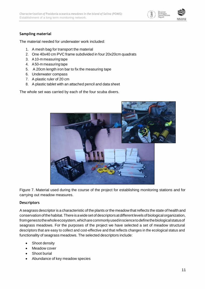
Sampling material
The material needed for underwater work included:
1. A mesh bag for transport the material
2. One 40x40 cm PVC frame subdivided in four 20x20cm quadrats
3. A 10-m measuring tape
4. A 50-m measuring tape
5. A 20cm length iron bar to fix the measuring tape
6. Underwater compass
7. A plastic ruler of 20 cm
8. A plastic tablet with an attached pencil and data sheet
The whole set was carried by each of the four scuba divers.
Figure 7. Material used during the course of the project for establishing monitoring stations and for
carrying out meadow measures.
Descriptors
A seagrass descriptor is a characteristic of the plants or the meadow that reflects the state of health and
conservation of the habitat. There is a wide set of descriptors at different levels of biological organization,
from genes to the whole ecosystem, which are commonly used in science to define the biological status of
seagrass meadows. For the purposes of the project we have selected a set of meadow structural
descriptors that are easy to collect and cost-effective and that reflects changes in the ecological status and
functionality of seagrass meadows. The selected descriptors include:
• Shoot density
• Meadow cover
• Shoot burial
• Abundance of key meadow species

Characterization of Posidonia oceanica meadows in the Island of Salina (POMIS):
Establishment of a long term monitoring network.
12
w
Shoot density
Shoot density is the number of shoots per unit of
surface area of the seabed. Due to the high
number of plants within a meadow, which in
shallow meadow stands can be higher than 1000
shoots m-2, the descriptor is measured by
counting the number of shoots within 40x40 cm
quadrats and expressed as number of shoots per
m2. The descriptor reflects the abundance of
plants and, when measured on the same quadrat
in successive years, is a good indicator of P.
Figure 8. Scuba diver counting shoots within a 40x40 cm
fixed quadrat to calculate shoot density
oceanica population dynamics and of the
evolution of the meadow structure. This measure
is conducted twice in each of the four fixed
quadrats and averaged to estimate shoot density of a particular meadow area.
Meadow cover
The descriptor meadow cover, which is also a measure of abundance, reflects the proportion of the sea
bottom that is covered by plants. The descriptor is calculated through a visual estimation of the percentage
of seabed that is covered by living plants. The estimation is done using a 40x40 cm square-frame subdivided
into four 20x20 cm sub-squares. The percentage of meadow cover is estimated for each of the four 20x20
quadrats and then averaged. The measure is repeated on each meter along a 10-m measuring tape, and
then averaged for the whole 10m-transect. In order to make the estimation comparable between different
years, measuring tapes (i.e. transects) should be extended following a given angle from the fixed quadrat.
Meadow cover is estimated for each of the four fixed sampling points (i.e. Q1 – Q4) and then averaged to
represent the percentage of meadow cover of the site.
Figure 9. Scuba divers performing a visual estimate of the percentage of seabed covered by living plants to estimate
meadow cover.
Shoot burial
The descriptor is an estimation of the degree of burial of plants and can give indication of changes in the
sedimentary dynamics of the site. Shoot burial is characterized by measuring the vertical distance between
the seafloor and the ligule of the outermost leaf of the shoot. The value of the measure and its sign depend

Characterization of Posidonia oceanica meadows in the Island of Salina (POMIS):
Establishment of a long term monitoring network.
13
Visual census of meadow-associated macrofauna
Sea stars Fan worm
(Sabella spallanzanii)
Sea cucumbers
Fan musell
(Pinna nobilis) Sea urchins
Visual census of meadow invaders
Caulerpa cylindracea Caulerpa taxifolia
on the net balance between plant vertical growth and the sedimentary dynamic of the site: i) the sign of
the descriptor is positive when the seafloor is below the ligule; ii) the value is zero when the sediment
surface is at the height of the ligule and; iii) the sign is negative when the ligule is below the seafloor and
hence, buried inside the sediments. A clear progressive trend of the descriptor indicates changes in the
sedimentary dynamics of the area. For instance, plants are progressively buried if excessive sedimentation
occurs within the meadow, which represent a real threat for the species due to its high sensitivity to burial.
On the contrary, under a situation of deficit in sediment accretion within the meadow or increased erosion,
plants are progressively more exposed and thus, more vulnerable to high hydrodynamic and strong
currents. This measure is conducted in five randomly selected shoots from the proximity of each fixed
sampling point.
Abundance of key meadow species
The descriptor gives an idea of the presence and abundance of species of interest in the studied meadow.
These species play a key role in the functioning the ecosystem (e.g. herbivores, feeding filters) or are
considered unique, vulnerable or threatened. We have also included a few invasive species that have the
potential to out-compete native species. The abundance of the selected species is recorded when they are
found inside the 40x40 cm quadrats used along the 10 m transect for meadow cover estimation.
Sea urchins (Paracentrotuslividus and Sphaerechinusgranularis) are generalist herbivore echinoderms that
feed on algae and seagrass leaves, as well as on plant debris, some sessile animals and organic particles
from the water column. Their abundance within P. oceanica meadows is generally low but their populations
can sharply increase due to increased organic matter inputs or the removal of their predators. Under such
circumstances, sea urchins have the potential to alter the meadow structure through increased herbivory
pressure.
Figure 10. List of meadow-associated macrofauna and meadow invaders selected in the project.
Fan worms (Sabella spallanzanii) are polychaetetube worms with a filter feeding habit. They capture
bacteria, plankton (zooplankton and phytoplankton) and suspended particles of organic matter with their
feeding tentacles. They are considered common indicators of good water quality.

Characterization of Posidonia oceanica meadows in the Island of Salina (POMIS):
Establishment of a long term monitoring network.
14
Sea cucumbers (Holothuriasp) are detritivous echinoderms that feed on organic particles adhered to
sediments including microalgae. Their populations can grow under conditions of increased matter content
in sediments being in such cases considered indicators of sediment quality.
Fun mussel (Pinna nobilis) is the larger bivalve mollusk in the Mediterranean Sea. The species is endemic of
the Mediterranean Sea, where it lives along a bathymetic gradient from 0.5 m down to 60 m depth. The
species has a filter-feeding diet and is abundant within P. oceanica meadows due to the high primary
productivity of the meadows and their role in the retention of suspended particles. It is highly vulnerable to
pollution and to the mechanical impact produced by anchoring and trawling. P. nobilis populations are
experiencing mass mortality across a wide geographical area of the western Mediterranean Sea in the last
two years, reaching 100% mortality rates in some regions (e.g. Levantine coast of Spain). The cause seems
to be a digestive parasite, specifically a protozoan of the genus Haplosporidium that is putting them in
danger of extinction.
Sea stars (Ophidiastersepositus) are omnivore echinoderms that mainly feed on mollusks and brittle stars
and carrion.
Caulerpa cylindracea and C. taxifolia are one of the major seaweed invaders in the Mediterranean. Since
the beginning of the 90’s they have rapidly spread all around the Mediterranean causing ecological and
economic damage. Dense and healthy P. oceanica meadows are resistant to the invasion of these species,
mainly due to the strong light reduction caused by the meadow canopy that limits the successful growth of
the invaders. Disturbed meadows, however, are vulnerable to the spread of these species and most
impacted P. oceanica meadows are at present colonized by at least one of these alien species. The
production of allelopathic substances by these seaweeds has the potential to produce adverse effects on P.
oceanica plants as well.

Characterization of Posidonia oceanica meadows in the Island of Salina (POMIS):
Establishment of a long term monitoring network.
15
)
3.-RESULTS
STATION 1: TRE PIETRE
The monitoring station 1 is located in the southern coast of the Island of Salina at approximately 50 meters
off the three small rocky reefs that give rise to its name, Tre Pietre. The bottom in the area is mainly rocky
with a marked slope and with the presence of big boulders and stones produced by cliffs erosion. The four
fixed sampling points constituting the station were distributed within a large meadow patch following the
15 meter bathymetric line. Installation of sampling points and the completion of the measurements was
done on the 12th of June 2018. The geographical coordinates of the station are shown in Table 1.
Figure 11. Geographic location of Tre Pietre station (upper panel) and schematic representation of the sampling
station with the four fixed 40x40 cm density quadrats (Q1-Q4) and 10-m length cover transects (lower panel).
Station name Tre Pietre
Depth
Coordinates – Latitude
Coordinates – Longitude
Sampling date
15m
38° 32.135' N
14° 50.904' E
12/06/2018
Table 1.Tre Pietre station, general information.
Q1
Q3 Q4 Q2
MEADOW
0 5 10 m
Tre Pietre (15m)
SAND
RO
CK

Characterization of Posidonia oceanica meadows in the Island of Salina (POMIS):
Establishment of a long term monitoring network.
16
S
Q
The average meadow density of the station was 736 ± 198 shoots m-2, with minimum and maximum values
of 519 and 988 shoots m-2, respectively. The percentage of meadow cover varied between 48.5 and 74.9,
with an average value of 64.4 ± 13.0 %.
1200
1000
800
600
400
200
0
Figure 12. Values of meadow density (left panel) and cover (right panel) of the four fixed sampling points (Q1-Q4) of
the Tre Pietre station. Grey dashed lines represent the average value for the station.
Shoot burial was fairly homogeneous and ranged between 5.4 and 6.4 cm, with an average value of 5.8 ±
0.4 cm. Although the site is frequented by sport divers no signs of regression or impacts were visually
detected in the area, as supported by the positive and homogeneous values of shoot burial. Novel divers
usually produce sediment resuspension with two potential negative effects on plants. One is the reduction
in the amount of light available for plants to growth; and the other is plant burial, which can be lethal for
the species when the frequency of divers is high in the area. The station, which is far from human
settlements, did not show signs of regression or damage and no invasive algae were observed in the area.
One fan worm was recorded inside the 40 x 40 cover quadrats.
BURIAL
10
8
6
4
2
0
Q1 Q2 Q3 Q4
Sampling point
Figure 13. Values of shoot burial in the four fixed sampling points (Q1-Q4) of the Tre Pietre station. The grey dashed
line represents the average value for the station.
DEN ITY COVER
100
80
60
40
20
0
Q1 Q2 Q3 Q4 Q1 Q2 3 Q4
Sampling point Sampling point
Sh
oo
t d
ensity (
sh
oo
ts/m
2)
Sh
oo
t b
uri
al (c
m)
Me
ad
ow
co
ve
r (%
)

Characterization of Posidonia oceanica meadows in the Island of Salina (POMIS):
Establishment of a long term monitoring network.
17
Figure 14. A 10-meters long transect extended above the meadow for the characterization of meadow cover at the Tre
Pietre station.
Figure 15. A fan worm growing within the Tre Pietre station.

Characterization of Posidonia oceanica meadows in the Island of Salina (POMIS):
Establishment of a long term monitoring network.
18
STATION 2: MALFA TORRICELLA
The Malfa Torricella station is located in the north side of the Island of Salina at ca. 1.5 km to the east of the
port of Malfa town. The name of the station is given by a tall tower-like rock located nearby, that is is
actually the interior lava of a volcano. The outer cone crumbled a long time ago and the solidified magma
was left giving the aspect of a tower (Torricella in Italian). The station was set up on the 13th June 2018 at
300 m from the shore line and at a depth of 17 m. The seascape of the site is mainly shaped by the
presence of small and midium sized P. oceanica patches intermingled with sand patches and channels and
with the presence of boulders of different shapes and sizes.
Figure 16. Geographic location of MalfaTorricella station (red square, left panel) and schematic representation of the
sampling station with the four fixed 40x40 cm density quadrats (Q1-Q4) and 10-m length cover transects (right panel).
Station name MalfaTorricella
Depth
Coordinates – Latitude
Coordinates – Longitude Sampling date
17m
38° 35.066' N
14° 51.348' E
13/06/2018
Table 2. Malfa Torricella station, general information.
The sampled meadow at Malfa Torricella station was characterized by an average shoot density of 609 ± 85
shoots m-2, with values ranging from 531 to 722 shoots m-2. The percentage of the sea bottom covered by
living plants was in average 50.9 ± 13 %, with minimum and maximum meadow cover values of 36.5 and
61.1 respectively. Meadow cover values of the Q3 sampling point was not considered for the calculation of
10 m 5 0
Q4
SAND
Q3
MEADOW
Q2
Q1
Malfa Torricella (17m)
RO
CK

Characterization of Posidonia oceanica meadows in the Island of Salina (POMIS):
Establishment of a long term monitoring network.
19
Y
n
station average value, since they were recorded along a 10-meter transect almost completely extended on
sandy bottoms outside meadow patches.
1200
1000
800
600
400
200
0
Figure 17. Values of meadow density (left panel) and cover (right panel) of the four fixed sampling points (Q1-Q4) of
the Malfa Torricella station. Grey dashed lines represent the average value for the station.
Shoot burial in the site ranged between 2.8 and 7.2 cm, with an average value of 5.2 ± 1.8 cm. The station
did not evidence sign of altered sediment dynamics, and the variability among sampling points reflected
the distance of the fixed quadrats from the meadow edges. Higher burial values (lower positive or higher
negative values) are usually found in the meadow borders, where sand waves are constrained and retained
by the physical structure of the meadow.
BURIAL
10
8
6
4
2
0
Q1 Q2 Q3 Q4
Sampling point
Figure 18. Values of shoot burial in the four fixed sampling points (Q1-Q4) of the Malfa Torricela station. The grey
dashed line represents the average value for the station.
DENSIT COVER
100
80
60
40
20
0
Q1 Q2 Q3 Q4 Q1 Q2
x Q3 Q4
Sampling point Sampli g point
Sh
oo
t d
ensity (
sh
oo
ts/m
2)
Sh
oo
t bu
rial (c
m)
Me
ad
ow
co
ve
r (%
)

Characterization of Posidonia oceanica meadows in the Island of Salina (POMIS):
Establishment of a long term monitoring network.
20
The presence of the alga C. cylindracea was recorded in the station. This invasive species was only observed
outside the meadow, growing on sandy and rocky substrates where it formed low-density and low-biomass
patches. The presence of dead Pinna nobilis individuals was also recorded in the station. No signs of
damage were detected on the studied meadow, and the ecosystem as well as the associated community
seems to be in a good ecological status.
Figure 19. Seascape at the Malfa Torricella station showing the presence of two divers working on two fixed sampling
points marked with a small buoy.
Figure 20. A detailed view of the use of an underwater compass to roll out the 10 meters transect used for the
characterization of the meadow cover.

Characterization of Posidonia oceanica meadows in the Island of Salina (POMIS):
Establishment of a long term monitoring network.
21
STATION 3: PORTO SHALLOW
The Porto Shallow station is located about 300 meters south of Santa Marina’s harbour and 100 meters off
the eastern coast of the Island. The station was installed in the upper limit of the meadow on the 14th of
June 2018. The four fixed sampling points were distributed from 6 to 10 meters depth, the higher depths
corresponging to the sampling stations closest to the Port of Santa Marina (Q1 and Q2), where the upper
meadow limit were more strongly regreessed most likely due to the influence of the harbour. A great
number of vessels have been observed during the sampling campains in the area, which is one of the most
frequented and important areas for anchoring and mooring in the Island.
Figure 21. Geographic location of Porto Shallow station (red square, left panel) and schematic representation of the
sampling station with the four fixed 40x40 cm density quadrats (Q1-Q4) and 10-m length cover transects (right panel).
Station name Porto shallow
Depth
Coordinates – Latitude
Coordinates – Longitude
Sampling date
6-10 m
38° 33.137' N
14° 52.184' E
14/06/2018
Table 3. Porto Shallow station, general information..
Shoot density was uniform between fixed sampling points with values ranging from 591 to 688 shoots m-2,
and an average value of 652 ± 43 shoots m-2. Meadow cover was also homogenous and showed an
averaged value of 42.0 ± 7.0 %. Density and cover values in this shallow station were lower than the values
obtained in other stations at shallower depths (e.g. Station 1 and 2), contrary to what expected for an
undisturbed meadow. Under undisturbed conditions, the natural structure of P. oceanica meadows is
progressively reduced due to the strong attenuation that light experiences with depth. The fact that the
10 m 5 0
Q4
Q3
Q2
MEADOW
SAND
Q1
Porto shallow (6-10 m)

Characterization of Posidonia oceanica meadows in the Island of Salina (POMIS):
Establishment of a long term monitoring network.
22
Y V
n
Porto Shallow meadow is less dense and sparser than nearby deeper meadows is likely reflecting the
existence of perturbations in the area. In fact, the presence of scars produced by anchors and chains were
observed inside the meadow as well as in the surrounding sandy bottoms.
1200
1000
800
600
400
200
0
Figure 22. Values of meadow density (left panel) and cover (right panel) of the four fixed sampling points (Q1-Q4) of
the Porto Shallow station. Grey dashed lines represent the average value for the station.
Shoot burial ranged between 1.6 and 8.2 cm, with an average value of 5.4 ± 2.9 cm. One sea cucumber was
found inside one cover quadrats and the presence of Caulerpa cylindraceawithin the meadow margins was
recorded. It is also important to note the presence of mixed meadows of the pioneer seagrass Cymodocea
nodosa and the introduced Halophila stipulacea together with the invasive seaweed C. cylindracea in
degraded areas adjacent to the monitoring station, were the meadow has totally disappeared. In fact, the
proportion of muddy and silty sediments in the area, which is indicative of sediment resuspension by the
mechanical action of anchors, was visually higher than in other stations from this side of the Island without
apparent disturbance (e.g. Stations 5 and 9).
BURIAL
10
8
6
4
2
0
Q1 Q2 Q3 Q4
Sampling point
Figure 23. Values of shoot burial in the four fixed sampling points (Q1-Q4) of the Porto Shallow station. The grey
dashed line represents the average value for the station.
DENSIT CO ER
100
80
60
40
20
0
Q1 Q2 Q3 Q4 Q1 Q2 Q3 Q4
Sampling point Sampli g point
Sh
oo
t d
ensity (
sh
oo
ts/m
2)
Sh
oo
t bu
rial (c
m)
Me
ad
ow
co
ve
r (%
)

Characterization of Posidonia oceanica meadows in the Island of Salina (POMIS):
Establishment of a long term monitoring network.
23
In summary, the meadow to the south of Santa Marina’s Port seems to be highly damaged by boat
anchoring. Large meadow areas have already disappeared and in some cases they have been substituted by
mixed beds of lower-sized and faster-growing pioneer seagrass species. This change in species composition
has enormous consequences for the functions and services provided by seagrasses, since they are
intimately linked to the physical structure of the meadows. Moreover, we have observed dispersed around
the meadow a large number of abandoned mooring systems for boats and boats directly anchoring inside
the meadow. Given the current situation, we suggest to activate urgent measures in order to protect the P.
oceanica meadows in the area and to favour a sustainable use of this sheltered side of the Island for boat
mooring.
Figure 24. General views of the Porto Shallow station. On the left: Detail of the upper meadow limit dead matte
evidencing the regressive status of the meadow. On the right: Presence of a boat anchored inside the meadow very
close to the monitoring station, where the presence of boats is high during the summer season.
Figure 25. Presence of mixed meadow patches formed by the pioneer seagrass Cymodocea nodosa and the introduced
Halophila stipulacea together with the invasive seaweed C. cylindracea in degraded areas adjacent to the Porto
Shallow station (left panel). Presence of abandoned mooring systems in the surroundings of the monitored meadow.
Characterization of Posidonia oceanica meadows in the Island of Salina (POMIS):
Establishment of a long term monitoring network.
24
STATION 4: RINELLA
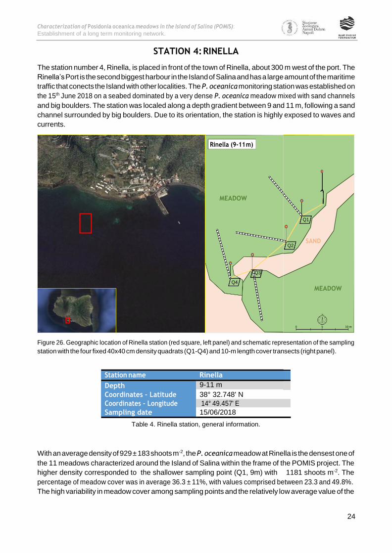
The station number 4, Rinella, is placed in front of the town of Rinella, about 300 m west of the port. The
Rinella’s Port is the second biggest harbour in the Island of Salina and has a large amount of the maritime
traffic that conects the Island with other localities. The P. oceanica monitoring station was established on
the 15th June 2018 on a seabed dominated by a very dense P. oceanica meadow mixed with sand channels
and big boulders. The station was localed along a depth gradient between 9 and 11 m, following a sand
channel surrounded by big boulders. Due to its orientation, the station is highly exposed to waves and
currents.
Figure 26. Geographic location of Rinella station (red square, left panel) and schematic representation of the sampling
station with the four fixed 40x40 cm density quadrats (Q1-Q4) and 10-m length cover transects (right panel).
Station name Rinella
Depth
Coordinates – Latitude
Coordinates – Longitude
Sampling date
9-11 m
38° 32.748' N
14° 49.457' E
15/06/2018
Table 4. Rinella station, general information.
With an average density of 929 ± 183 shoots m-2, the P. oceanica meadow at Rinella is the densest one of
the 11 meadows characterized around the Island of Salina within the frame of the POMIS project. The
higher density corresponded to the shallower sampling point (Q1, 9m) with 1181 shoots m-2. The
percentage of meadow cover was in average 36.3 ± 11%, with values comprised between 23.3 and 49.8%.
The high variability in meadow cover among sampling points and the relatively low average value of the
Rinella (9-11 m)
MEADOW
Q3
Q4
10 m 5 0
MEADOW
Q2 SAND
Q1

Characterization of Posidonia oceanica meadows in the Island of Salina (POMIS):
Establishment of a long term monitoring network.
25
Y OV
station reflects the high heterogeneity of the habitat in this locality, where small and medium meadow
patches are intermingled with sand channels and boulders of different shape and size.
1200
1000
800
600
400
200
0
Figure 27. Values of meadow density (left panel) and cover (right panel) of the four fixed sampling points (Q1-Q4) of
the Rinella station. Grey dashed lines represent the average value for the station.
Shoot burial was in average 3.3 ± 1.9 cm, being the lowest value 0.6 cm in Q2 and the highest 4.6 in Q3.
This variability is again reflecting the heterogeneity of the habitat. Indeed, we did not observe visible signs
of deterioration and the environmental status of meadow seems to be very good. Accordingly, the
associated meadow community was also well represented and preserved. Many fish species were observed
within and around the meadow and two sea stars were found inside cover quadrats. Caulerpa cylindracea
was also observed sparse in the station, but without showing signs of an invasive character since the
patches of this seaweed were quite small and not very dense.
BURIAL
10
8
6
4
2
0
Q1 Q2 Q3 Q4
Sampling point
Figure 28. Values of shoot burial in the four fixed sampling points (Q1-Q4) of the Rinella station. The grey dashed line
represents the average value for the station.
DENSIT C ER
100
80
60
40
20
0
Q1 Q2 Q3 Q4 Q1 Q2 Q3 Q4
Sampling point Sampling point
Sh
oo
t d
ensity (
sh
oo
ts/m
2)
Sh
oo
t bu
rial (c
m)
Me
ad
ow
co
ve
r (%
)

Characterization of Posidonia oceanica meadows in the Island of Salina (POMIS):
Establishment of a long term monitoring network.
26
Currently, the construction of a new port adjacent to the one already existing at Rinella is being planned
with the aim to increase the provision of controlled boat mooring in the Island, and in order to reduce the
number of free anchoring boats that are actually damaging P. oceanica meadows on the western coast of
the Island. The construction of this coastal infrastructure, however, could have direct and indirect negative
consequences for the existing coastal habitats in the area. The direct effects include the physical
occupation of the environment with the resultant destruction of the natural habitats present in the area.
Indirect effects are mainly caused by the modification of coastal currents, which generally results on
alterations of the sediment dynamic in the area, as well as the toxic effects of pollution derived from boats
and port activities. Due to the high ecological value of the meadow growing in the vicinity of the area
where the new harbour is planned to be constructed, it is critical to conduct a detailed environmental study
that includes any potential direct and indirect effect that the construction of the port could have on this
valuable ecosystem. The study should also include various alternatives to allow selecting the more
environmental respectful option.
Figure 29. The seascape at the Rinella monitoring station is dominated by the presence of very dense P. oceanica
patches intermingled with big boulders and sand patches and channels.
Figure 30. The P. oceanica meadow at Rinella is the densest meadow we found around the Island of Salina.

Characterization of Posidonia oceanica meadows in the Island of Salina (POMIS):
Establishment of a long term monitoring network.
27
STATION 5: LINGUA SHALLOW
The station 5 Lingua Shallow is located in the southeast of the Island of Salina. In particular, the station is
situated on the east coast of the Island at approximately 800 m to the south of Porto Shallow station
(Station 3) and 100 m in front of the cementery of the locality. The instalation of sampling points and the
characterization of the meadow were conduted on the 16th June 2018. The four fixed samping points of the
station were distributed around a sand patch sorrounded by a wide P. oceanica meadowat 6 m depth. In
the Lingua Shallow station P. oceanica grows on a flat slope bottom creating a dense and wide meadow
from very shallow waters down to 9-10 meters depth, after which the bottom slope sharply changes down
to the lower meadow limit at about 20-22 m depth. This meadow morphology contrast to other areas of
the Island where the species grows on steep slopes forming narrow meadow bands instead of extensive
meadows.
Figure 31. Geographic location of Lingua shallow station (red square, left panel) and schematic representation of the
sampling station with the four fixed 40x40 cm density quadrats (Q1-Q4) and 10-m length cover transects (right panel).
Station name Lingua shallow
Depth
Coordinates – Latitude
Coordinates – Longitude
Sampling date
6 m
38° 32.683' N
14° 52.237' E
16/06/2018
Table 5. Lingua Shallow station, general information.
In the shallow stand of the meadow, shoot density showed in average 713 ± 225 shoots per m2, being the
maximum density value (Q4, 988 shoots m-2) almost the double than the lower one (Q3, 531 shoots m-2).
This variability is mainly due to the formation of submarine terraces (called "mattes") in the area, although
we cannot discard the existence of perturbations, due to the high number of boats mooring and
frequenting the area. Indeed, although we have not visually identified clear signs of damage in the
monitoring station, these signs were evident during a diving survey in adjacent areas. In this shallow site
the meadow develops submarine terraces of high vertical thickness (up to 1.5-2 m) formed by the
interwoven dead rhizomes and trapped sediment that remains below the living plants of the meadow. The
creation of these organic structures that trap large amount of organic material and lower the energy of
waves, protecting the coastline, is favoured by the flat slope of the seabed and the sheltered characteristics
10 m 5 0
MEADOW
Q2
SAND Q3
Q1
Q4
Lingua shallow (6 m)

Characterization of Posidonia oceanica meadows in the Island of Salina (POMIS):
Establishment of a long term monitoring network.
28
Y V
n
of the locality. Meadow cover was high in the station, with an average value of 65.1 ± 20%. This high
percentage of meadow cover reflects the structural homogeneity of the meadow, favoured by the flat
slope and the absence of big boulders due to the lack of abrupt cliffs in the surrounding coastline.
1200
1000
800
600
400
200
0
Figure 32. Values of meadow density (left panel) and cover (right panel) of the four fixed sampling points (Q1-Q4) of
the Lingua Shallow station. Grey dashed lines represent the average value for the station.
Shoot burial in the station ranged between 3 and 7.5 cm, with an average value of 5.2 ± 1.8 cm. We have
observed a high abundance of dead Pinna nobilisin the area, some of them damaged and broken most
likely due to the use of anchors. It is worth to note that we have not found one single living Pinna nobilis all
around the Island of Salina, which lead us to think that local populations have experienced a marked
decline as recently described in other regions of the Mediterranean Sea where 100% of mortality have
been recorded in the last two years. Curiously, we have found a Pencil sea urchin (Cidaris sp) in one of the
fixed 40x40 cm density quadrats at 6 m depth, when the species is commonly found in deep waters (down
to 1800 m depth) of the Mediterranean Sea.
BURIAL
8
6
4
2
0
Q1 Q2 Q3 Q4
Sampling point
Figure 33. Values of shoot burial in the four fixed sampling points (Q1-Q4) of the Lingua Shallow station. The grey
dashed line represents the average value for the station.
DENSIT CO ER
100
80
60
40
20
0
Q1 Q2 Q3 Q4 Q1 Q2 Q3 Q4
Sampling point Sampli g point
Sh
oo
t d
ensity (
sh
oo
ts/m
2)
Sh
oo
t b
uri
al (c
m)
Me
ad
ow
co
ve
r (%
)

Characterization of Posidonia oceanica meadows in the Island of Salina (POMIS):
Establishment of a long term monitoring network.
29
Figure 34. General view of the shallow wide meadow of Lingua Shallow station (left panel). The sand patch around
which the monitoring station was installed (right panel).
Figure 35. Matte of Posidonia oceanica (submarine terraces) in the vicinity of Lingua Shallow station (left panel). The
Pencil sea urchin Cidaris sp found inside a fixed density sampling point (upper right panel). Presence of dead Pinna
nobilis (fan shell) in the surroundings of the station (lower right panel).

Characterization of Posidonia oceanica meadows in the Island of Salina (POMIS):
Establishment of a long term monitoring network.
30
STATION 6: SCOGLIO CACATO
The Scoglio Cacato station is located in the Northern side of the Eastern coasts of the Island of Salina,
where it is possible to admire the volcanic aspect of the Island and the high cliffs formed by rocky layers of
different colors and composition emerging from the crystalline sea waters. The name of the station is given
by the accumulation of bird faeces on rocks emerging from the sea near the coastline. The station was
established on the 16th June 2018, on the deep limit of a P. oceanica meadow. Covering a meadow portion
between 25 and 28 m depth, the Scoglio Cacato station is the deepest of the 11 stations studied in the
POMIS project. The area is highly frequented by recreational boats and the site is also of interest by sport
divers.
Figure 36. Geographic location of Scoglio Cacatostation (red square, left panel) and schematic
representation of the sampling station with the four fixed 40x40 cm density quadrats (Q1-Q4) and 10-m
length cover transects (right panel).
Station name ScoglioCacato
Depth
Coordinates – Latitude
Coordinates – Longitude
Sampling date
25-28 m
38° 34.548' N
14° 52.403' E
16/06/2018
Table 6. Scoglio Cacato station, general information.
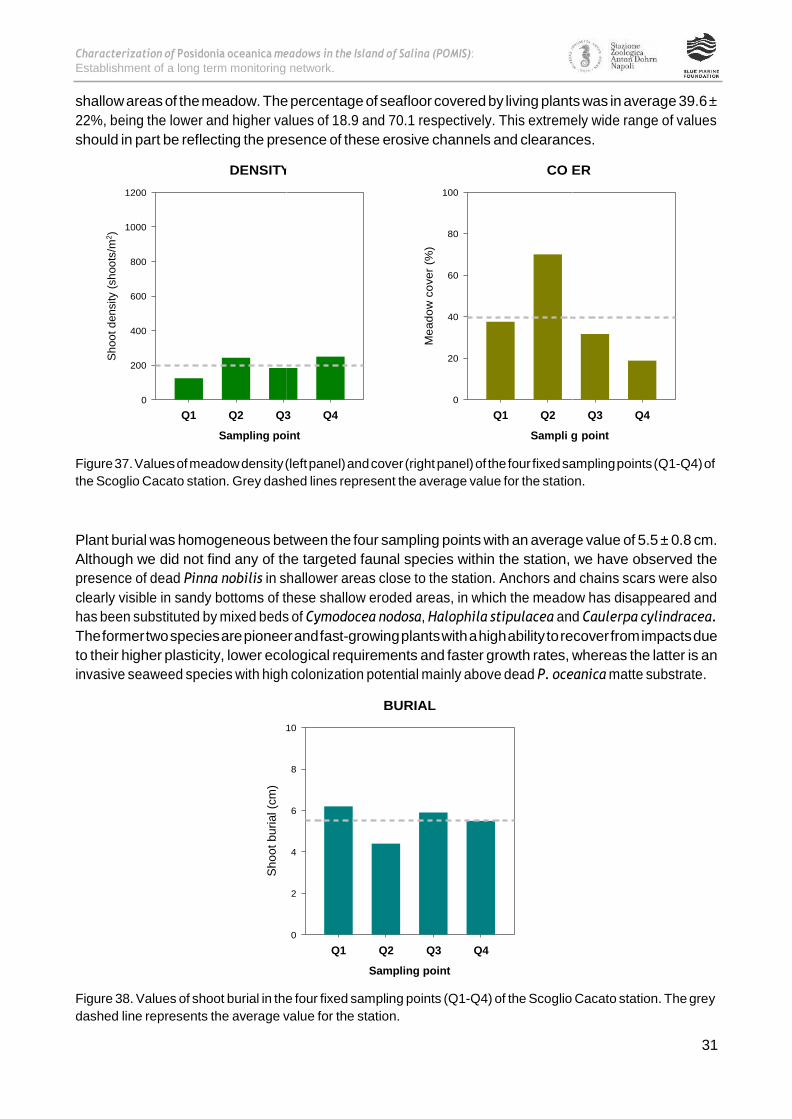
The monitoring station was positioned within a tongue-shaped meadow of several meters width that
spreads from 14 m depth down to 30 m on a steep slope sea-bottom. Plant density in this site was the
lower of all studied stations around the Island of Salina, which is in accordance with its highest depth. The
average meadow density at the moment of sampling was 201 ± 59 shoots m-2 (range: 125-250 shoots m-2).
However, plant density in one of the 40x40 cm fixed quadrats was very low, with only 20 living shoots. The
cause of such a dramatic reduction in the number of shoots is probably due to the mechanical effect of
anchors. Large, heavy anchors dig up plants from the seafloor creating clearings and channels without
vegetation. Subsequently, these meadow bounds act as an erosive front progressively increasing the
surface area of unvegetated seafloor, as a result of hydrodynamic forces. In fact, the erosion channels
created by anchors were clearly visible during sampling not only in the deep meadow stand but also in
10 m 5 0
MEADOW
Q1
Q4 Q2
Q3
SAND
Scoglio Cacato (25-28 m)
Characterization of Posidonia oceanica meadows in the Island of Salina (POMIS):
Establishment of a long term monitoring network.
31
Y V
n
shallow areas of the meadow. The percentage of seafloor covered by living plants was in average 39.6 ±
22%, being the lower and higher values of 18.9 and 70.1 respectively. This extremely wide range of values
should in part be reflecting the presence of these erosive channels and clearances.
1200
1000
800
600
400
200
0
Figure 37. Values of meadow density (left panel) and cover (right panel) of the four fixed sampling points (Q1-Q4) of
the Scoglio Cacato station. Grey dashed lines represent the average value for the station.
Plant burial was homogeneous between the four sampling points with an average value of 5.5 ± 0.8 cm.
Although we did not find any of the targeted faunal species within the station, we have observed the
presence of dead Pinna nobilis in shallower areas close to the station. Anchors and chains scars were also
clearly visible in sandy bottoms of these shallow eroded areas, in which the meadow has disappeared and
has been substituted by mixed beds of Cymodocea nodosa, Halophila stipulacea and Caulerpa cylindracea.
The former two species are pioneer and fast-growing plants with a high ability to recover from impacts due
to their higher plasticity, lower ecological requirements and faster growth rates, whereas the latter is an
invasive seaweed species with high colonization potential mainly above dead P. oceanica matte substrate.
BURIAL
10
8
6
4
2
0
Q1 Q2 Q3 Q4
Sampling point
Figure 38. Values of shoot burial in the four fixed sampling points (Q1-Q4) of the Scoglio Cacato station. The grey
dashed line represents the average value for the station.
DENSIT CO ER
100
80
60
40
20
0
Q1 Q2 Q3 Q4 Q1 Q2 Q3 Q4
Sampling point Sampli g point
Sh
oo
t d
ensity (
sh
oo
ts/m
2)
Sh
oo
t bu
rial (c
m)
Me
ad
ow
co
ve
r (%
)

Characterization of Posidonia oceanica meadows in the Island of Salina (POMIS):
Establishment of a long term monitoring network.
32
Figure 39. Overall views of the degraded and fragmented lower meadow edge of the P. oceanica meadow at the
Scoglio Cacato station. Anchor scars, clearly visible as unvegetated channels, facilitate
meadow.
erosion processes in the
Figure 40. In shallow meadow areas at the Scoglio Cacato station, the eroded meadow has been colonized by pioneer
species. This species substitution has important consequences for the functioning of the ecosystem since the much
lower complexity of the habitat precludes the provision of important human services such as coastal protection,
carbon sequestration or fisheries maintenance. Note the presence of some relict P. oceanica plants within the newly
formed patches of the low-sized species Cymodocea nodosa and Halophila stipulacea.

Characterization of Posidonia oceanica meadows in the Island of Salina (POMIS):
Establishment of a long term monitoring network.
33
STATION 7: MALFA SPIAGGIA
The Malfa Spiaggia station is located west of Malfa at approximately 200 m of the town’s beach, on the
Island’s northern coast. The four fixed sampling points were distributed along a sand channel at 17 m
depth, on the 17th June 2018. The dense and wide P. oceanica meadow is crossed by sand channels and
riddled with boulders covered by a well developed photophilic community of canopy-forming algae. The
meadow was visually healthy without signs of deterioration despite its close prossimity to the town of
Malfa of less than a thousand residents. Here the coast is higher, with a steep cliff and very suggestive sea.
Figure 41. Geographic location of Malfa Spiaggia station (red square, left panel) and schematic
representation of the sampling station with the four fixed 40x40 cm density quadrats (Q1-Q4) and 10-m
length cover transects (right panel).
Station name MalfaSpiaggia
Depth
Coordinates – Latitude
Coordinates – Longitude
Sampling date
17 m
38° 35.043' N
14° 50.014' E
17/06/2018
Table 7. Malfa Spiaggia station, general information.
Plant density varied between 481 and 697 shoots m-2, with an average value of 606 ± 90 shoots m-2 for the
station. Meadow cover was also high with a mean percentage of 66.9 ± 11, and with a maximum and
minimum value of 57.6 and 80.7% respectively. Shoot burial ranged between 3 and 4.9 cm, with an average
value of 3.6 ± 0.8 cm.
Q1
MEADOW
Malfa Spiaggia (17 m)
10 m 5 0
SAND
Q2
Q3
Q4

Characterization of Posidonia oceanica meadows in the Island of Salina (POMIS):
Establishment of a long term monitoring network.
34
Y V
n
1200
1000
800
600
400
200
0
Figure 42. Values of meadow density (left panel) and cover (right panel) of the four fixed sampling points (Q1-Q4) of
the Malfa Spiaggia station. Grey dashed lines represent the average value for the station.
During our dives in the station we have observed the presence of dense fish shoals of the species Chromis
chromis, Sarpa salpa and Oblada melanura swimming around the meadow. Well represented in the station
were also some common fish species of the Labridae and Sparidae family, swiming inside the meadow in
search of protection and food.
BURIAL
6
5
4
3
2
1
0
Q1 Q2 Q3 Q4
Sampling point
Figure 43. Values of shoot burial in the four fixed sampling points (Q1-Q4) of the Malfa Spiaggia station. The grey
dashed line represents the average value for the station.
DENSIT CO ER
100
80
60
40
20
0
Q1 Q2 Q3 Q4 Q1 Q2 Q3 Q4
Sampling point Sampli g point
Sh
oo
t d
ensity (
sh
oo
ts/m
2)
Sh
oo
t bu
rial (c
m)
Me
ad
ow
co
ve
r (%
)

Characterization of Posidonia oceanica meadows in the Island of Salina (POMIS):
Establishment of a long term monitoring network.
35
Figure 44. Plant counting inside a fixed 40 x 40 cm quadrat for the determination of plant density.
Figure 45. Dense fish shoals of the species Oblada melanura swimming around the monitoring station.
Characterization of Posidonia oceanica meadows in the Island of Salina (POMIS):
Establishment of a long term monitoring network.
36
STATION 8: PORTO DEEP
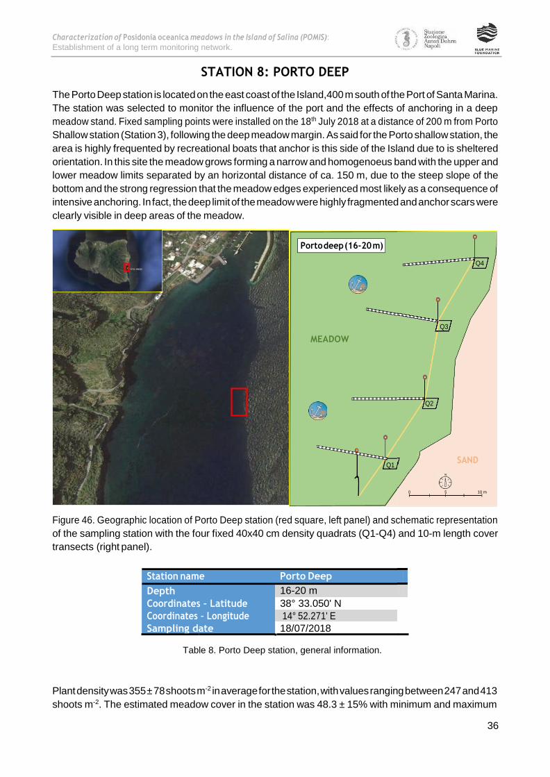
The Porto Deep station is located on the east coast of the Island,400 m south of the Port of Santa Marina.
The station was selected to monitor the influence of the port and the effects of anchoring in a deep
meadow stand. Fixed sampling points were installed on the 18th July 2018 at a distance of 200 m from Porto
Shallow station (Station 3), following the deep meadow margin. As said for the Porto shallow station, the
area is highly frequented by recreational boats that anchor is this side of the Island due to is sheltered
orientation. In this site the meadow grows forming a narrow and homogenoeus band with the upper and
lower meadow limits separated by an horizontal distance of ca. 150 m, due to the steep slope of the
bottom and the strong regression that the meadow edges experienced most likely as a consequence of
intensive anchoring. In fact, the deep limit of the meadow were highly fragmented and anchor scars were
clearly visible in deep areas of the meadow.
Figure 46. Geographic location of Porto Deep station (red square, left panel) and schematic representation
of the sampling station with the four fixed 40x40 cm density quadrats (Q1-Q4) and 10-m length cover
transects (right panel).
Station name Porto Deep
Depth
Coordinates – Latitude
Coordinates – Longitude
Sampling date
16-20 m
38° 33.050' N
14° 52.271' E
18/07/2018
Table 8. Porto Deep station, general information.
Plant density was 355 ± 78 shoots m-2 in average for the station, with values ranging between 247 and 413
shoots m-2. The estimated meadow cover in the station was 48.3 ± 15% with minimum and maximum
10 m 5 0
SAND Q1
Q2
MEADOW
Q3
Q4
Porto deep (16-20 m)

Characterization of Posidonia oceanica meadows in the Island of Salina (POMIS):
Establishment of a long term monitoring network.
37
3
values of 28.8% to 61.4% respectively. The great variation in meadow cover should in part be reflecting the
fragmented condition of this meadow stand. Clearances and sand channels created by the mechanical
effect of big anchors are intermingled and dispersed within the meadow area included in the monitoring
station. In fact, a great number of recently uprooted plant fragments was observed inside and outside the
meadow.
500
400
300
200
100
0
Figure 47. Values of meadow density (left panel) and cover (right panel) of the four fixed sampling points (Q1-Q4) of
the Porto Deep station. Grey dashed lines represent the average value for the station.
The mechanical effects of anchors are also visible in the level of plant burial, which also showed high
variability among sampling stations. These values ranged between 0.6 and 6.34 cm, with an average of 3.8
± 2.4 cm. Anchors move and rework a great quantity of marine sediments in the sea bottom, giving rise to
an irregular plant burial. This mechanical effect also produces sediment resuspension that finally resulted in
sediment siltation in the area. Sediments in the station were, indeed, muddy and they were easily re-
suspended during our sampling work. This has a potential negative effect, since deep meadow margins are
quite sensitive to burial and to the light reduction produced by the resuspension of fine sediments.
BURIAL
7
6
5
4
3
2
1
0
Q1 Q2 Q3 Q4
Sampling point
Figure 48. Values of shoot burial in the four fixed sampling points (Q1-Q4) of the Porto Deep station. The grey dashed
line represents the average value for the station.
DENSITY COVER
70
60
50
40
30
20
10
0
Q1 Q2 Q Q4 Q1 Q2 Q3 Q4
Sampling point Sampling point
Sh
oo
t d
ensity (
sh
oo
ts/m
2)
Sh
oo
t bu
rial (c
m)
Me
ad
ow
co
ve
r (%
)

Characterization of Posidonia oceanica meadows in the Island of Salina (POMIS):
Establishment of a long term monitoring network.
38
Therefore, the strong regression experienced by the deep meadow margin in this site should be favoured
by a combination of burial, shading and the mechanical pulling up of plants, all them produced by anchors.
Figure 49. View of the fragmented meadow margin at Porto Deep station. The current lower limit of the meadow is at
18-22 m due to the strong regression experienced by the meadow. Rooted and unrooted plant fragments observed
below the meadow edges provide strong evidences of this regression. The accumulation of muddy sediments and the
increased water turbidity produced during sampling activities are also visible in the photo.
Figure 50. Detailed view of clearances and channels produced by boat anchoring in the Porto Deep station.

Characterization of Posidonia oceanica meadows in the Island of Salina (POMIS):
Establishment of a long term monitoring network.
39
Ponta Barone (7 m)
STATION 9: PUNTA BARONE
The Punta Barone station is located in the eastern side of the Island of Salina at approximately one
kilometer to the north of Santa Marina’s Harbour. In contrast to other sites of the Island, here the P.
oceanica meadow was extensive, thanks to the flat slope of the seabottom that allows the meadow to grow
over a large area before reaching the lower depth limit. On the 19th July 2018, the station was instaled
around a patch of coarse sand at 7 m depth. The meadow was apparently healthy and visually appealing
due to the presence of P. oceanica terraces (i.e. matte). The seawater of turquoise and cobalt-blue color
and the abundance of fish are other attractive aspects of the site. The proximity of the Punta Barone beach
seems to reduce the presence of anchored boats, which prefer the rocky coast or the vicinity of ports, they
find in other sites of this sheltered side of the Island.
Figure 51. Geographic location of Punta Barone station (red square, left panel) and schematic
representation of the sampling station with the four fixed 40x40 cm density quadrats (Q1-Q4) and 10-m
length cover transects (right panel).
Station name Punta Barone
Depth
Coordinates – Latitude
Coordinates – Longitude Sampling date
7 m
38° 34.149' N
14° 52.457' E
19/07/2018
Table 9. Punta Barone station,general information.
Plant density in this station was high with 709 ± 60 shoots m-2 in average, values ranging from 644 to 788
shoots m-2. Meadow cover was also high as reflected by the elevated percentage of sea bottom covered by
living plants, which in average was 73.3 ± 6 %. Meadow cover along the four 10-m cover transects was
quite homogenous from a minimum of 68% to a maximum of 80.6%. Plant burial was in average 4.0 ± 1.3
10 m 5 0
MEADOW
Q2
Q3
Q1
SAND
Q4
Punta Barone (7 m)

Characterization of Posidonia oceanica meadows in the Island of Salina (POMIS):
Establishment of a long term monitoring network.
40
Y OV
cm. Although the meadow around the monitoring station looked healthy and well conserved, we have
observed large pieces of meadow uprooted by the effect of anchors in a visual survey conducted in the
surroundings.
1000
800
600
400
200
0
Figure 52. Values of meadow density (left panel) and cover (right panel) of the four fixed sampling points (Q1-Q4) of
the Punta Barone station. Grey dashed lines represent the average value for the station.
We have also observed in the vicinity of the station high number of dead Pinna nobilis lying above the sea
bottom. In some cases, the valves of dead individuals were occupied by other organisms as for instance
Octopus sp. We have also observed in the area many P. oceanica seedlings growing attached to different
substrates including dead P. oceanica matte, sediments and even, the valves of dead P. nobilis. Curiously,
we found two P. oceanica seedlings growing inside of the meadow, in particular inside one of the fixed
40x40 cm quadrats. Large shoals of fishes (Boops boops, Chromis chromis, Diplodus spp) were also observed
around the station attracting predatory fishes such as groups of Seriola dumerili. A fire worm was observed
in one of the sampling points as well as the introduced seagrass Halophila stipulacea recently growing in
some meadow margins.
BURIAL
7
6
5
4
3
2
1
0
Q1 Q2 Q3 Q4
Sampling point
Figure 53. Values of shoot burial in the four fixed sampling points (Q1-Q4) of the Punta Barone station. The grey
dashed line represents the average value for the station.
DENSIT C ER
100
80
60
40
20
0
Q1 Q2 Q3 Q4 Q1 Q2 Q3 Q4
Sampling point Sampling point
Sh
oo
t d
ensity (
sh
oo
ts/m
2)
Sh
oo
t bu
rial (c
m)
Me
ad
ow
co
ve
r (%
)

Characterization of Posidonia oceanica meadows in the Island of Salina (POMIS):
Establishment of a long term monitoring network.
41
Figure 54. Scuba diver showing one detached piece of meadow formed by healthy long-lived P. oceanica
plants (estimated to be more than 30 years old) in the surroundings of the monitoring station (left panel).
The presence of a P. oceanica seedling growing inside the meadow, in particular inside one of the fixed
quadrats used to monitor meadow density (right panel).
Figure 55. Large shoals of fish around the Punta Barone monitoring station (right panel). A group of
predatory fishes of the genus Seriola patrolling the area in search of preys (upper right panel).

Characterization of Posidonia oceanica meadows in the Island of Salina (POMIS):
Establishment of a long term monitoring network.
42
STATION 10: LINGUA FARO
The Lingua Faro station is located in the southeastern part of the Island of Salina, 300 m to the south of the
Lingua’s Lighthouse. The four sampling points of the station were distributed along the meadow margins of
two different sand patches at 13 m depth. P. oceanica terraces of one to two meters in height were
observed at that depth. The sea bottom showed a flat slope in shallow meadow areas, while after 14 m
depth the slope sharply increases down to the lower meadow limit at 25-28 m depth. In the lower meadow
limit we have observed a large amount of broken shoots totally unburied possibly due to the strong slope,
the presence of unconsolidated sediments and the existence of strong currents favoured by the bottom
geomorphology of the Lingua Cape (Punta Lingua). Evidences of damage by anchors or fishing nets were
also observed between 15 and 25 m depth but not in shallower areas.
Figure 56. Geographic location of Lingua Faro station (red square, left panel) and schematic representation
of the sampling station with the four fixed 40x40 cm density quadrats (Q1-Q4) and 10-m length cover
transects (right panel).
Station name Lingua Faro
Depth
Coordinates – Latitude
Coordinates – Longitude
Sampling date
13 m
38° 32.066' N
14° 52.233' E
20/07/2018
Table 10. Lingua Faro station, general information.
Shoot density at the Lingua Faro station was in average 511 ± 139 shoots m-2, with values distributed within
the range 384 – 700 shoots m-2. The mean value of meadow cover was 61 ± 18 %, being the lowest and
highest percentages of 41.8 and 85.3 respectively.
10 m 5 0
SAND
Q1 Q2
Q3
MEADOW
SAND
Lingua Faro (13 m) Q4
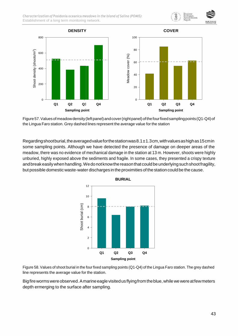
Characterization of Posidonia oceanica meadows in the Island of Salina (POMIS):
Establishment of a long term monitoring network.
43
3
800
600
400
200
0
Figure 57. Values of meadow density (left panel) and cover (right panel) of the four fixed sampling points (Q1-Q4) of
the Lingua Faro station. Grey dashed lines represent the average value for the station
Regarding shoot burial, the averaged value for the station was 8.1 ± 1.3 cm, with values as high as 15 cm in
some sampling points. Although we have detected the presence of damage on deeper areas of the
meadow, there was no evidence of mechanical damage in the station at 13 m. However, shoots were highly
unburied, highly exposed above the sediments and fragile. In some cases, they presented a crispy texture
and break easily when handling. We do not know the reason that could be underlying such shoot fragility,
but possible domestic waste-water discharges in the proximities of the station could be the cause.
BURIAL
12
10
8
6
4
2
0
Q1 Q2 Q3 Q4
Sampling point
Figure 58. Values of shoot burial in the four fixed sampling points (Q1-Q4) of the Lingua Faro station. The grey dashed
line represents the average value for the station.
Big fire worms were observed. A marine eagle visited us flying from the blue, while we were at few meters
depth ermerging to the surface after sampling.
DENSITY COVER
100
80
60
40
20
0
Q1 Q2 Q Q4 Q1 Q2 Q3 Q4
Sampling point Sampling point
Sh
oo
t d
ensity (
sh
oo
ts/m
2)
Sh
oo
t bu
rial (c
m)
Me
ad
ow
co
ve
r (%
)

Characterization of Posidonia oceanica meadows in the Island of Salina (POMIS):
Establishment of a long term monitoring network.
44
Figure 59. Overview of the Lingua Faro monitoring station.
Figure 60. Big bearded fire worm (Hermodicecarunculata) seeking refuge within the P. oceanica matte
(upper left panel). Sea eagle (Myliobatisaquila) swimming above the Lingua Faro station during the
sampling campaign (upper right panel). Accumulation of uprooted P. oceanica fragments in the lower
meadow limit at Lingua Faro station (lower left panel). General view of the fragmented deep meadow
margin and the accumulation of detached plant fragments at 25 m depth in the Lingua Faro station (lower
right panel).

Characterization of Posidonia oceanica meadows in the Island of Salina (POMIS):
Establishment of a long term monitoring network.
45
STATION 11: LINGUA DEEP
On the 21st July 2018 the Lingua Deep station was installed in the southeastern part of the Island of Salina.
The station was located 150 m to the southeast of the Lingua Shallow station (station 5) with the aim to
monitor the deep area of this important and extensive meadow. The four sampling stations (Q1-Q4) were
distributed along the deep meadow margin at 22 m depth. The characteristics of this meadow area are
quite similar to those of the Porto Deep station, located about 700 m to the north. In fact, both stations
takes part of the same extensive meadow whose deep stands grow in a steep slope bottom and are highly
impacted by the intensive use of this side of the Island for boats anchoring. The abrupt slope in this side of
the island favours and intensifies the impact produced by anchors, as it concentrates recreational boats
along a small band parallel to the coast coinciding with the presence of the meadow. The marked slope also
favours anchors dragging from shallower to deeper bottoms affecting the deep meadow limits, that would
be more distant form the coast if the slope were lower.
Figure 61. Geographic location of Lingua deep station (red square, left panel) and schematic representation
of the sampling station with the four fixed 40x40 cm density quadrats (Q1-Q4) and 10-m length cover
transects (right panel).
Station name Lingua deep
Depth
Coordinates – Latitude
Coordinates – Longitude
Sampling date
22 m
38° 32.621' N
14° 52.307' E
21/07/2018
Table 11. Lingua Deep station, general information.
Q4
10 m 5 0
Q3
MEADOW
Q2
Q1
Lingua Deep (22 m)
SA
ND

Characterization of Posidonia oceanica meadows in the Island of Salina (POMIS):
Establishment of a long term monitoring network.
46
Me
ad
ow
co
ve
r (%
)
Meadow density was 246 ± 75 shoots m-2 in average for the station, with values comprised within a wide
range from 150 to 331 shoots m-2. Meadow cover also showed a great variation form 25 to 4 2%, being the
mean coverage for the station of 34 ± 9 %. Plant burial varied between 3.6 and 8.1 cm with an average
value of 6.0 ± 2.2 cm for the station. Anchor scars were visible all along the meadow margin, which was
highly fragmented and in a clear regressive state. Due to the intense mechanical perturbation of the sea
bottom, sediments showed high clay and lime content, being therefore easily resuspended during our work
in the station.
350
DENSITY COVER
50
300
40
250
200 30
150 20
100
10
50
0
Q1 Q2 Q3 Q4
Sampling point
0
Q1 Q2 Q3 Q4
Sampling point
Figure 62. Values of meadow density (left panel) and cover (right panel) of the four fixed sampling points (Q1-Q4) of
the Lingua Deep station. Grey dashed lines represent the average value for the station
The presence of fan worms (Sabella spallanzanii) was observed within the monitoring station. We have also
observed dense groups of the hatpin urchin (Centrostephanus longispinus) growing at the basis of P.
oceanica plants in this deep meadow portion. The species is probably attracted by the accumulation of leaf
debris and the red and brown algae usually growing at the basis of the plants and above the leaves
(epiphytes).
BURIAL
10
8
6
4
2
0
Q1 Q2 Q3 Q4
Sampling point
Figure 63. Values of shoot burial in the four fixed sampling points (Q1-Q4) of the Lingua Deep station. The grey dashed
line represents the average value for the station.
Sh
oo
t d
ensity (
sh
oo
ts/m
2)
Sh
oo
t bu
rial (c
m)

Characterization of Posidonia oceanica meadows in the Island of Salina (POMIS):
Establishment of a long term monitoring network.
47
Figure 64. Overall view of the deep meadow limit at the Lingua Deep station.
Figure 65. Detailed view of the deep meadow stand at Lingua where the presence of bounds (clearances and
channels) produced by anchoring can be easily appreciated.
Figure 66. The hatpin urchin Centrostephanus longispinus formed aggregates of many individuals in the Lingua Deep
station.
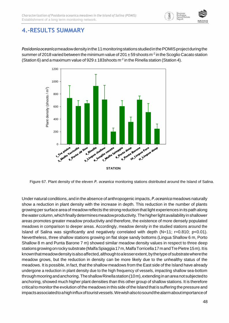
Characterization of Posidonia oceanica meadows in the Island of Salina (POMIS):
Establishment of a long term monitoring network.
48
a
4.-RESULTS SUMMARY
Posidonia oceanica meadow density in the 11 monitoring stations studied in the POMIS project during the
summer of 2018 varied between the minimum value of 201 ± 59 shoots m-2 in the Scoglio Cacato station
(Station 6) and a maximum value of 929 ± 183shoots m-2 in the Rinella station (Station 4).
1200
1000
800
600
400
200
0
Figure 67. Plant density of the eleven P. oceanica monitoring stations distributed around the Island of Salina.
Under natural conditions, and in the absence of anthropogenic impacts, P.oceanica meadows naturally
show a reduction in plant density with the increase in depth. This reduction in the number of plants
growing per surface area of meadow reflects the strong reduction that light experiences in its path along
the water column, which finally determines meadow productivity. The higher light availability in shallower
areas promotes greater meadow productivity and therefore, the existence of more densely populated
meadows in comparison to deeper areas. Accordingly, meadow density in the studied stations around the
Island of Salina was significantly and negatively correlated with depth (N=11; r=0.810; p<0.01).
Nevertheless, three shallow stations growing on flat slope sandy bottoms (Lingua Shallow 6 m, Porto
Shallow 8 m and Punta Barone 7 m) showed similar meadow density values in respect to three deep
stations growing on rocky substrate (Malfa Spiaggia 17 m, Malfa Torricella 17 m and Tre Pietre 15 m). It is
known that meadow density is also affected, although to a lesser extent, by the type of substrate where the
meadow grows, but the reduction in density can be more likely due to the unhealthy status of the
meadows. It is possible, in fact, that the shallow meadows from the East side of the Island have already
undergone a reduction in plant density due to the high frequency of vessels, impacting shallow sea-bottom
through mooring and anchoring. The shallow Rinella station (10 m), extending in an area not subjected to
anchoring, showed much higher plant densities than this other group of shallow stations. It is therefore
critical to monitor the evolution of the meadows in this side of the Island that is suffering the pressure and
impacts associated to a high influx of tourist vessels. We wish also to sound the alarm about importance of
STATION
Pla
nt
de
nsity (
sh
oo
ts /
m2)

Characterization of Posidonia oceanica meadows in the Island of Salina (POMIS):
Establishment of a long term monitoring network.
49
D
o
cel
1_T
3_P
4_R
5_L
6_S
8_P
9_P
10_
11_
controlling and regulating boats anchoring around the Island of Salina by the competent authorities and to
carefully estimate the possible impact of the new port in Rinella.
ENSITY VS DEPTH Density = 969.71 + 27.503 * Depth
(r= 0.810; p<0.01) 0
-10
-20
-30
re Pietre (15m)
2_Malfa Torricella (17m)
orto shallow (8m)
inella (10m)
ingua shallow (6m)
coglio cacato (27m)
7_Malfa spiaggia (17m)
orto deep (18m)
onta Barone (7m)
Lingua Faro (13m)
Lingua deep (22m)
0 200
400 600 800 1000
Sho t density (# shoots / m2)
Figure 68. Linear regression of meadow density against meadow depth. Red circles indicate the two groups of
meadows (shallower and deeper) with similar densities but contrasting depths (see the text).
100
80
60
40
20
0
STATION
Figure 69. Meadow cover of the eleven P. oceanica monitoring stations distributed around the Island of Salina.
Meadow cover in the eleven studied sites ranged between 34 ± 9 % in the Lingua Deep station (22 m depth)
and 73 ± 6 % in Punta Barone station (7 m). Contrary to plant density, this structural parameter meadow
has not such a close relationship with depth, and no significant correlation was found between both
De
pth
(m
)
Me
ado
w c
ove
r (%
)

Characterization of Posidonia oceanica meadows in the Island of Salina (POMIS):
Establishment of a long term monitoring network.
50
2_M
3_P
4_R
6_S
7_M
8_P
9_P
parameters. The percentage of meadow cover, in the absence of a perturbation, mainly varies depending
on the heterogeneity of the seabed, among other factors. In accordance, one of the highest and the lowest
percentages of meadow cover corresponded to two shallow stations. The meadow at Rinella station (10 m)
grows on bottoms of high structural heterogeneity, where sand channels are intermingled with big and
medium sized boulders, and showed one of the lowest meadow cover recorded in this study, even if the
meadow has the higher plant density. On the contrary, the meadow at Punta Barone (7 m) spreads on a flat
slope sandy bottom and showed the highest percentages of meadow cover. Besides the natural variability
in meadow cover as a function of natural factors, this structural parameter also varies depending on the
degree of perturbation since it reflects meadow fragmentation and its thinning out. Indeed, human
disturbances should be the cause for the great differences in meadow cover between two stations at
similar depths: Porto Shallow (8 m) and Lingua Shallow (6 m) stations, both on the East coast of the Island.
The former station with high boat density and visible anchor scars showed 42 % of meadow cover; whereas
the later station located further from the Santa Marinas’ Port and without clear signs of anchor damage
had a 65 % of meadow cover.
COVER vs DEPTH
5
0
-5
-10
-15
-20
-25
1_Tre Pietre (15m)
alfa Torricella (17m)
orto shallow (8m)
inella (10m)
5_Lingua shallow (6m)
coglio cacato (27m)
alfa spiaggia (17m)
orto deep (18m)
onta Barone (7m)
10_Lingua Faro (13m)
11_Lingua deep (22m)
-30
30 40
50 60 70 80
Meadow cover (%)
Figure 70. Linear regression of meadow cover against meadow depth.
The level of shoot burial in all studied sites varied between 3.3 ± 1.9 cm in the Rinella station and 8.1 ± 1.3
cm in the Lingua Faro station. Although we cannot draw conclusions from the values obtained for this
parameter, the high unburial level of shoots in the latter station together with the fragility and crispy
characteristics of the shoots warn that the station could be experiencing some kind of perturbation that
can be of natural (e.g. changes in current pattern) or human (e.g. inflow of nutrients) origin. It is therefore
important to focus the attention on the evolution of this meadow and to identify any possible human
activity that could be affecting the environmental quality of this locality.
Me
ad
ow
de
pth
(m
)

Characterization of Posidonia oceanica meadows in the Island of Salina (POMIS):
Establishment of a long term monitoring network.
51
l
o
10
8
6
4
2
0
Figure 71. Shoot burial of the eleven P. oceanica monitoring stations distributed around the Island of Salina.
STATION
Sh
oo
t bu
rial (c
m)

Characterization of Posidonia oceanica meadows in the Island of Salina (POMIS):
Establishment of a long term monitoring network.
52
5.-CONCLUSIONS AND RECOMMENDATIONS
Within the frame of the POMIS project we have installed a series of long-term monitoring stations and
characterized the structure of P. oceanica meadows at 11 different sites around the Island of Salina. Data
derived from such characterization are presented in the present report with the aim to establish base
values for each of the studied meadows that will be used as a benchmark to determine the future evolution
of the P. oceanica meadows in the Island. The data set here presented is not, in itself, useful for
determining with certainty the current ecological status of the meadows, for which other measurements at
the physiological, biochemical and molecular levels are needed. The underlying value of this first
characterization is based on their utility in the coming years as the initial state against which future changes
of the meadows can be compared. It is, therefore, of great importance to continue characterizing, in the
long term and on an annual basis, the structure of these meadows. Long-term data series will make it
possible to discriminate natural cyclic changes of the meadows from the changes induced by human
activities and by the human-induced climate change. This information will be precious for the proper
conservation and adequate management of these valuable coastal ecosystems in the Aeolian Islands. One
way to guarantee the provision of future data and to make the project more sustainable over the long term
could be the involvement of diving centres from the Island and voluntary recreational scuba divers. This
model is currently in use in many other places of the Mediterranean with great success; and would add a
new social objective to the project, to promote education and environmental awareness among citizens.
Voluntary divers need to be initially trained by marine biologist to gain knowledge about P. oceanica
ecosystem and to produce accurate data, which is key for the correct characterization of meadows
evolution.
Although the data here presented is not diagnostic of the conservation status of the studied meadows, as
commented above, together with visual field observations they can be useful to warn about the possible
existence of threats to the studied meadows. In this sense, the work conducted within the frame of the
POMIS project is useful for raising awareness on the significant impact and regression that P. oceanica
meadows from the Eastern coast of the Island are currently experiencing. All studied deep meadows in this
side of the island are in regression and continue to suffer anchor damage, as we have noticed during our
sampling surveys. Shallow meadow stands in the area are also highly impacted by boats anchoring, and the
impact continues as testified by the presence of detached living fragments of the meadows. Meadows at
any depth also show numerous wide scars and clearances produced by the boats mooring in the area; the
existing wounds represent active erosion edges that can continue eroding the meadows, even if boat
anchoring is prevented. Due to the extensive impact of anchoring, it is of key importance to lay down rules
governing mooring and anchoring along the east coast of the Island in order to ensure the sustainable
development of the Island, which is highly dependent on tourism. Nowadays there are environmental
friendly alternatives to reconcile mooring of recreational vessels with P. oceanica meadow preservation.
Furthermore, we have observed the presence of many abandoned mooring systems all along the east coast
of the Island. The rehabilitation and servicing of these systems that are not currently in use, could be a first
action intended to protect the valuable P. oceanica meadows from Salina. During the writing of the present
project we have heard about the existence of a proposal for the construction of two new Piers about 200 m
to the west of the Port of Rinella aimed to increase the number of anchorage points and to reduce the
current anchoring pressure on the East side of the Island. We would therefore like to bring to the attention
of the relevant public agencies about the importance of conducting comprehensive environmental impact
analysis that include the main coastal habitats in the area and various possible alternatives, in order to
avoid irreversible damage to valuable ecosystems such as the P. oceanica meadows. It is worth to note that
in the area in which the new Piers are planned to be constructed exists a healthy and wide P. oceanica
meadow with the larger shoot density values of all characterized meadows around the Island.

Characterization of Posidonia oceanica meadows in the Island of Salina (POMIS):
Establishment of a long term monitoring network.
53
Dozens of dead fun mussels (Pinna nobilis), a species strictly protected at European level (Annex IV of EEC
Habitat Directive, 1992),were observed around the Island, many of them lying on the seabed while others
still attached to the seafloor in their upright position. The valves of dead individuals provide a hard
substrate and were colonized by organisms such as sponges, algae and bryozoans. In other cases, they were
occupied by octopuses that use the shells as a refuge. Strangely enough, we have found no one P. nobilis
alive in any of the monitoring stations in which we have conducted our diving surveys, which allows us to
suspect about the mass mortality of the species and the possible extinction of local populations around the
Island. Mass mortality events of this endemic bivalve have been documented in several regions of the
Western Mediterranean over the last two years. They first one occurred in the south-east of the Iberian
Peninsula and Balearic Islands in late 2016 and has been rapidly spreading over since, causing the mortality
of around 100% of individuals in all infected populations. To date, the mortality has been confirmed also in
several locations in Italy (Naples and Sicily). To our knowledge, this is the first observation of high mortality
of the species in the Island of Salina and possibly in the whole Aeolian archipelago, and should be
understood as an urgent call for action. The first conservation measures to be implemented are those
recently recommended by the UICN, and includes among others: i) the visual monitoring of the status of P.
nobilis and P. rudis populations on a monthly basis (mainly during the summer) and, ii) the reporting of any
unusual change in the populations. The P. oceanica monitoring network established in the present project
represents a powerful opportunity to monitor and control the populations of these iconic mollusc species
around the Island of Salina.
Several invasive and introduced species have been observed around the Island of Salina. The alien species
Caulerpa cylindracea var. racemosa grows in several places in which the monitoring stations have been
installed. The species was often growing in areas where the existing meadows showed evidence of damage
by boats anchoring. In the sandy bottoms surrounding these impacted meadows (e.g. Porto Shallow and
Scoglio Cacato stations) the seaweed forms extensive patches together with other pioneer and fast growing
seagrass species (C. nodosa and H. stipulacea). Degraded meadow borders were also colonized by the alien
species but the inner parts of the meadows were not invaded, most likely due to the strong light limitation
imposed by the dense canopies developed by the species. It is expected that the alien seaweed
progressively penetrates the meadows if anchoring continues to degrade them, lessening their structural
complexity by reducing plant density and meadow cover. The continuity of the monitoring programme
initiated by the POMIS project will be therefore key to determine not only the evolution of P. oceanica
meadows around the Island but also that of the invasive seaweed populations, and how the interaction
between both species determine the valuable functions and services provided by P. oceanica meadows in
Salina. It is also noteworthy to mention the first record in the Island of Salina of the introduced seagrass
species Halophila stipulacea in these impacted sites. Although the species is not showing an invasive
behaviour in the Mediterranean, contrary to what described in the Caribbean, the consequences of its
interaction with native seagrasses are unknown so far. Therefore, data derived from the monitoring
programme in the long-term could be useful to recognize the future trend of the species in the
Mediterranean and associated effects on native coastal communities. Furthermore, since its introduction in
the eastern Mediterranean through the Suez channel, the species is progressively spreading westward
likely due to the progressive seawater warming induced by the global climate change. In this sense, the
installation of temperature sensors in several localities of the Island, as planned within the POMIS project,
will produce seawater temperature time series of great value to ascertain the future trend of both seagrass
species in the Island of Salina and the western Mediterranean basin.

Characterization of Posidonia oceanica meadows in the Island of Salina (POMIS):
Establishment of a long term monitoring network.
54
6.- PHOTO GALLERY
Figure 72. Big meadow portions detached by the mechanical effect of anchors are present in P. oceanica meadows on
the East coast of the Island of Salina.

Characterization of Posidonia oceanica meadows in the Island of Salina (POMIS):
Establishment of a long term monitoring network.
55
Figure 73. High presence of recreational boats anchoring inside P. oceanica meadows from the eastern coast of the
Island of Salina

Characterization of Posidonia oceanica meadows in the Island of Salina (POMIS):
Establishment of a long term monitoring network.
56
Figure 74. Many abandoned mooring systems have been observed to the south of the Port of Santa Marina and other
areas on the east side of the Island of Salina.

Characterization of Posidonia oceanica meadows in the Island of Salina (POMIS):
Establishment of a long term monitoring network.
57
Figure 75. Dozens of dead pen shell (Pinna nobilis) individuals were observed around the Island of Salina. One single
living individual of Pinna rudis was observed on the eastern coast of the Island (Right-bottom corner).

Characterization of Posidonia oceanica meadows in the Island of Salina (POMIS):
Establishment of a long term monitoring network.
58
Figure 76. Some pictures of the POMIS working team during the field campaigns around the Island of Salina.