Case study - Croatia - RAC SPA · FIELD MANUAL FOR MONITORING OF POSIDONIA OCEANICA SEAGRASS...
15
FIELD MANUAL FOR MONITORING OF POSIDONIA OCEANICA SEAGRASS MEADOWS (POSIDONIA MEADOWS) Case study - Croatia
Transcript of Case study - Croatia - RAC SPA · FIELD MANUAL FOR MONITORING OF POSIDONIA OCEANICA SEAGRASS...
FIELD MANUAL FOR MONITORINGOF POSIDONIA OCEANICASEAGRASS MEADOWS(POSIDONIA MEADOWS)
Case study - Croatia
The designations employed and the presentation of the material in this document do not imply the expression of any opinion whatsoever on the part of UNEP/MAP-RAC/SPA concerning the legal status of any State, Territory, city or area, or of its authorities, or concerning the delimitation of their frontiers or boundaries. The views expressed in this publication do not necessarily reflect those of UNEP/MAP-RAC/SPA.
Published by: RAC/SPA
Copyright: © 2015 - RAC/SPA
Reproduction of this publication for educational or other non-commercial purposes is authorized without prior written permission from the copyright holder provided the source is fully acknowledged. Reproduction of this publication for resale or other commercial purposes is prohibited without prior written permission of the copyright holder.
For bibliographic purposes, this volume may be cited as:RAC/SPA - UNEP/MAP, 2014. Field Manual for Monitoring of Posidonia oceanica Seagrass Meadows (Posidonia Meadows). By Prvan M., Jakl Z. and Guala I. Ed. RAC/SPA - MedMPAnet Project, Tunis. 12 pages.
Layout: Zine El Abidine MAHJOUB and Asma KHERIJI.
Cover photo credit: Mosor PRVAN.Photos credits: Mosor PRVAN, Institute of Oceanography and Fisheries - Laboratory for Benthos, Ivan GUALA and Gérard PERGENT.
This document has been elaborated within the framework of the Regional Project for the Development of a Mediterranean Marine and Coastal Protected Areas (MPAs) Network through the boosting of Mediterranean MPAs Creation and Management (MedMPAnet Project).
The MedMPAnet Project is implemented in the framework of the UNEP/MAP-GEF MedPartnership, with the financial support of EC, AECID and FFEM.

FIELD MANUAL FOR MONITORING OF POSIDONIA OCEANICA SEAGRASS MEADOWS (POSIDONIA MEADOWS)
Regional Project for the Development of aMediterranean Marine and Coastal Protected
Areas (MPAs) Network through the boostingof MPA creation and management

FIEL
D M
ANUAL
FOR
MO
NIT
ORI
NG
OF
POSI
DONIA
OC
EANIC
A S
EAG
RASS
MEA
DOW
S (P
OSI
DONIA
MEA
DOW
S)
2
Study required and financed by:
Regional Activity Centre for Specially Protected Areas (RAC/SPA) Boulevard du Leader Yasser Arafat B.P. 337 1080 Tunis Cedex - Tunisia
In charge of the study:
Souha EL ASMI, MedMPAnet Project, RAC/SPA Atef LIMAM, MedMPAnet Project, RAC/SPA
Scientists and experts responsible of the study:
Authors: Mosor PRVAN, Association Sunce (Croatia)Zrinka JAKL, Association Sunce (Croatia)Ivan GUALA, Fondazione IMC - International Marine Centre (Italy)
Contributors: Meri BILAN, Association Sunce (Croatia)Patrik KRSTINIĆ, Public Institution Priroda (Croatia)Vedran NIKOLIĆ, Institute of Oceanography and Fisheries (Croatia)Ljiljana IVEŠA, Rudjer Boskovic Insitute - Center for Marine Research (Croatia)Željka RAJKOVIĆ, MedMPAnet Pilot Project Croatia - National Technical Coordinator (Croatia)
Reference of the study: MoU Nº 01/MedMPAnet/2013
FIEL
D M
ANUAL
FOR
MO
NIT
ORI
NG
OF
POSI
DONIA
OC
EANIC
A S
EAG
RASS
MEA
DOW
S (P
OSI
DONIA
MEA
DOW
S)
3
FIELD MANUAL FOR MONITORING OF POSIDONIA OCEANICA SEAGRASS MEADOWS (POSIDONIA MEADOWS)
This manual is an addition to the National monitoring protocol for Posidonia oceanica seagrass meadows. It is a reminder containing collected specific field experience in order to make it easier to conduct research and avoid errors in data collection. The manual exclusively deals with instructions regarding the collection of information necessary for monitoring and implies that all those who take part in data collection are experienced divers who are aware of their possibilities and constraints, who respect the diving safety rules and are acquainted with the National monitoring protocol for Posidonia oceanica seagrass meadows.
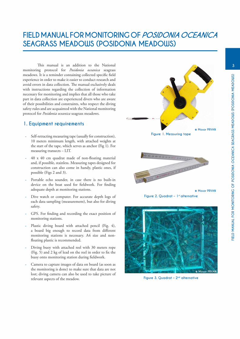
1. Equipment requirements
- Self-retracting measuring tape (usually for construction), 10 meters minimum length, with attached weights at the start of the tape, which serves as anchor (Fig 1). For measuring transects – LIT.
- 40 x 40 cm quadrat made of non-floating material and, if possible, stainless. Measuring tapes designed for construction can also come in handy, plastic ones, if possible (Figs 2 and 3).
- Portable echo sounder, in case there is no built-in device on the boat used for fieldwork. For finding adequate depth at monitoring stations.
- Dive watch or computer. For accurate depth logs of each data sampling (measurement), but also for diving safety.
- GPS. For finding and recording the exact position of monitoring stations.
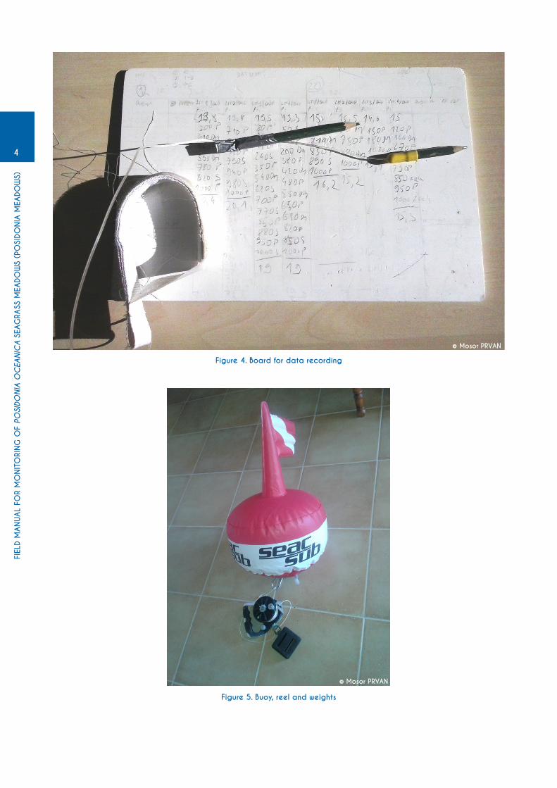
- Plastic diving board with attached pencil (Fig. 4), a board big enough to record data from different monitoring stations is necessary. A4 size and non-floating plastic is recommended.
- Diving buoy with attached reel with 30 meters rope (Fig. 5) and 2 kg of lead on the reel in order to fix the buoy onto monitoring station during fieldwork.
- Camera to capture images of data on board (as soon as the monitoring is done) to make sure that data are not lost; diving camera can also be used to take picture of relevant aspects of the meadow.
Figure 1. Measuring tape© Mosor PRVAN
© Mosor PRVAN
© Mosor PRVAN
Figure 2. Quadrat – 1st alternative
Figure 3. Quadrat – 2nd alternative
FIEL
D M
ANUAL
FOR
MO
NIT
ORI
NG
OF
POSI
DONIA
OC
EANIC
A S
EAG
RASS
MEA
DOW
S (P
OSI
DONIA
MEA
DOW
S)
4
Figure 4. Board for data recording
Figure 5. Buoy, reel and weights
© Mosor PRVAN
© Mosor PRVAN
FIEL
D M
ANUAL
FOR
MO
NIT
ORI
NG
OF
POSI
DONIA
OC
EANIC
A S
EAG
RASS
MEA
DOW
S (P
OSI
DONIA
MEA
DOW
S)
5
2. Field work preparation
It is important to mention to all participants that each person is responsible for his/her own equipment, diving equipment, as well as fieldwork equipment (diving board and pencil, quadrat, measuring tape).
Each participant is responsible to carry his/her equipment onto the boat and to return it into the base after the fieldwork. Research team leader should organize it in a way to make sure that is clear who is responsible for carrying other equipment onto the boat and its functioning, such as diving buoys and GPS.
It is necessary to take into account the following:
- Reel should not be entangled.
- Diving board should be wiped off from previous data.
- We suggest to draw a scheme from Figures 6 and 7 onto the diving board in advance, in order to find your way more easily, to be tidy and minimize the risk of forgetting to record certain data onto the diving board.
- Pencil attached to the diving board should be sharpened, and it is recommended to attach two pencils to the board, just in case, because their tips crack often and fall apart due to the effects of sea water.2
- Check if GPS batteries are full.
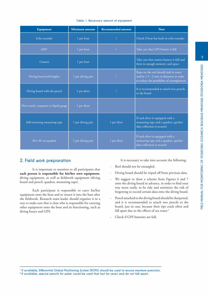
Table 1. Necessary amount of equipment
Equipment Minimum amount Recommended amount Note
Echo sounder 1 per boat / Check if boat has built-in echo sounder
GPS1 1 per boat / Take care that GPS battery is full
Camera 1 per boatTake care that camera battery is full and there is enough memory card space
Diving buoy/reel/weights 1 per diving pair /Rope on the reel should sink in water and be 1.5 - 2 mm in diameter in order to reduce the possibility of entanglement
Diving board with the pencil 1 per diver /It is recommended to attach two pencils to the board
Dive watch, computer or depth gauge 1 per diver
Self-retracting measuring tape 1 per diving pair 1 per diverIf each diver is equipped with a measuring tape and a quadrat, quicker data collection is secured
40 x 40 cm quadrat 1 per diving pair 1 per diverIf each diver is equipped with a measuring tape and a quadrat, quicker data collection is secured
1 If available, Differential Global Positioning System (DGPS) should be used to ensure maximum precision.2 If available, special pencils for water could be used that last for years and do not fall apart.

FIEL
D M
ANUAL
FOR
MO
NIT
ORI
NG
OF
POSI
DONIA
OC
EANIC
A S
EAG
RASS
MEA
DOW
S (P
OSI
DONIA
MEA
DOW
S)
6
Figure 6. Preparation of the form for recording data from the quadrat. In order for the form to be visible, it is written in larger letters here. Try to put as many monitoring stations as possible on one A4 side. Under «depth» you write down the exact depth at which the quadrat is located, and under «shoots» you write the number of Posidonia shoots in a quadrat.
Figure 7. Preparation of the form to record LITs onto the board. In order for it to be visible, the preparation is in bigger format here. So, when preparing, try to put at least 6 LITs on one side. First column shows a way how to input data.
If Posidonia is present from 0 to 120 cm of transect, then you do not record 0 – 120, you record only 120(it is understood that it starts from 0).
© Mosor PRVAN
© Mosor PRVAN

FIEL
D M
ANUAL
FOR
MO
NIT
ORI
NG
OF
POSI
DONIA
OC
EANIC
A S
EAG
RASS
MEA
DOW
S (P
OSI
DONIA
MEA
DOW
S)
7
Figure 8. Example of marking monitoring stations. Letter “A” is a group, and number represents data sampling. The first data sampling is conducted at deeper area (lower limit of the meadow). In case GPS marking has been done correctly, it will be
clear on the map, after the transfer of data, where each group dive and which data corresponds to which monitoring station.
3. Fieldwork and diving preparations
Before sailing out check if all necessary equipment is on board.
Once reaching the monitoring site, relevant information on coastal features (e.g. type of coast, exposition) and presence of potential human pressures (e.g. anchoring, mooring facilities, tourist structures, wastewater, camping area, villages) are recorded.
Recording GPS position
During the first monitoring campaign, after reaching the monitoring station and divers going into the water with all their equipment on (at the monitoring station determined by the Protocol), boat operator or other person responsible for recording GPS position of the monitoring station should wait until divers reach the bottom and fix the buoy. In other words, to find a position at which they will be working. This is determined by observing the buoy. In a moment when buoy at the surface stops moving, a GPS position of the monitoring station should be recorded (because it means that the divers have chosen the position to work at). It is recommended to name monitoring station already in the GPS device with the previously agreed names/codes, and inform divers upon their surfacing of the station name at which they were sampling and then divers write it onto the board. It is recommended that GPS device be set at original WGS84 coordinate system, in order to avoid subsequent mistakes and data incompatibility. Also, it is recommended that there is another person present on board
alongside the boat operator who passes equipment to the divers, records GPS positions and informs divers of the names of their respective monitoring stations. Sampling stations are usually in bays or along the coast where there is usually more maritime traffic and therefore higher risk for divers due to speedboats and other vessels. Boat operator and divers have to think about the safety by clearly marking diving buoys and avoiding high season and part of the day when maritime traffic is more intensive.
At the following monitoring events (field work activities), the buoy must be anchored (and the weight released) in the exact position marked on the GPS (waypoint); take care to approach the monitoring station very slowly and release the weight when the GPS indicates the distance to the waypoint as zero. Once the position has been reached and fixed with the buoy, divers can calmly prepare to dive.
Marking monitoring station
Each monitoring station should be clearly linked to the diving pair who is diving at that zone (with data on their board) and this consideration should be dealt with special attention in order to avoid mistakes during subsequent data entry. It is suggested that diving pairs are marked with letters and monitoring stations with numbers. For example:
Group A, at first monitoring station is A1, and each subsequent monitoring station that day is marked with other number (A2, A3…). The same applies for other groups. Monitoring stations have to have the same names in GPS device and on diving boards. Figure 8 shows how it looks like when it is transferred onto the map.
© Mosor PRVAN
FIEL
D M
ANUAL
FOR
MO
NIT
ORI
NG
OF
POSI
DONIA
OC
EANIC
A S
EAG
RASS
MEA
DOW
S (P
OSI
DONIA
MEA
DOW
S)
8
When finding exact monitoring stations, it is necessary to assess the lower limit of the Posidonia meadow as precisely as possible while still on board, using echo sounder and bathymetric maps, in order to avoid searching for it when diving. Posidonia meadows in the Adriatic are mostly distributed until the maximum depths of 25-28 m, in southern Adriatic a little bit deeper, up to 28-30 m. Sometimes in conditions of good visibility and shallow depth, it is possible to spot the lower limit of the meadow already from the boat. Still, in most cases it is necessary to find the lower limit using a mask from the sea surface or by short apnea dive. In case this is not possible, due to poor visibility or other reasons, the most probable location of the lower limit is taken, divers go into the sea and they should find the lower limit of the meadow by following the slope of the terrain towards the depth. In that case divers have to orient themselves and be careful to swim from shallower to greater depth in case Posidonia is below them, or to swim from greater to shallower depth in case sediment is below them. It is recommended not to dive next to the bottom, but at minimal depth from which they can clearly see the bottom and determine the location of the lower limit of the meadow, in order to reduce the air consumption.
Due to safety reasons, first data sampling or first station is always at the lower limit of the meadow, and final data sampling or final station is at the shallowest part that is being measured (fig. 8).
4. Diving and data collection
Just before descent, every diver has to check if he/she has all equipment required for data sampling. In case both divers have both measuring tape and quadrat, data sampling will most certainly be quicker, because one diver usually finishes earlier because of small number or shoots or higher meadow coverage and then he/she can assist the other diver.
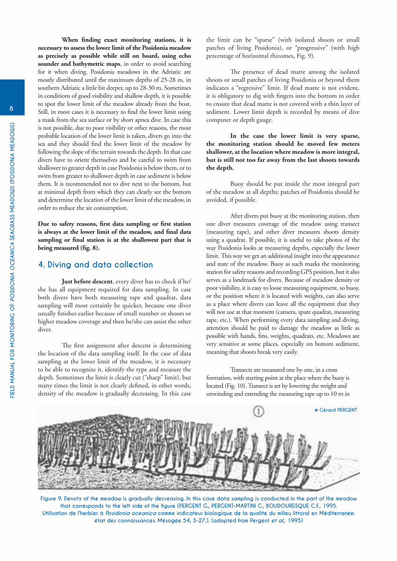
The first assignment after descent is determining the location of the data sampling itself. In the case of data sampling at the lower limit of the meadow, it is necessary to be able to recognize it, identify the type and measure the depth. Sometimes the limit is clearly cut (“sharp” limit), but many times the limit is not clearly defined, in other words, density of the meadow is gradually decreasing. In this case
the limit can be “sparse” (with isolated shoots or small patches of living Posidonia), or “progressive” (with high percentage of horizontal rhizomes, Fig. 9).
The presence of dead matte among the isolated shoots or small patches of living Posidonia or beyond them indicates a “regressive” limit. If dead matte is not evident, it is obligatory to dig with fingers into the bottom in order to ensure that dead matte is not covered with a thin layer of sediment. Lower limit depth is recorded by means of dive computer or depth gauge.
In the case the lower limit is very sparse, the monitoring station should be moved few meters shallower, at the location where meadow is more integral, but is still not too far away from the last shoots towards the depth.
Buoy should be put inside the most integral part of the meadow at all depths; patches of Posidonia should be avoided, if possible.
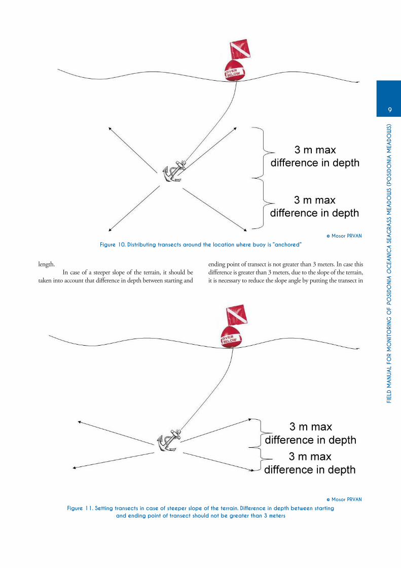
After divers put buoy at the monitoring station, then one diver measures coverage of the meadow using transect (measuring tape), and other diver measures shoots density using a quadrat. If possible, it is useful to take photos of the way Posidonia looks at measuring depths, especially the lower limit. This way we get an additional insight into the appearance and state of the meadow. Buoy as such marks the monitoring station for safety reasons and recording GPS position, but it also serves as a landmark for divers. Because of meadow density or poor visibility, it is easy to loose measuring equipment, so buoy, or the position where it is located with weights, can also serve as a place where divers can leave all the equipment that they will not use at that moment (camera, spare quadrat, measuring tape, etc.). When performing every data sampling and diving, attention should be paid to damage the meadow as little as possible with hands, fins, weights, quadrats, etc. Meadows are very sensitive at some places, especially on bottom sediment, meaning that shoots break very easily.
Transects are measured one by one, in a cross formation, with starting point at the place where the buoy is located (Fig. 10). Transect is set by lowering the weight and unwinding and extending the measuring tape up to 10 m in
Figure 9. Density of the meadow is gradually decreasing. In this case data sampling is conducted in the part of the meadow that corresponds to the left side of the figure (PERGENT G., PERGENT-MARTINI C., BOUDOURESQUE C.F., 1995.
Utilisation de l’herbier à Posidonia oceanica comme indicateur biologique de la qualité du milieu littoral en Méditerranée: état des connaissances. Mésogée 54, 3-27.). (adopted from Pergent et al., 1995)
© Gérard PERGENT
FIEL
D M
ANUAL
FOR
MO
NIT
ORI
NG
OF
POSI
DONIA
OC
EANIC
A S
EAG
RASS
MEA
DOW
S (P
OSI
DONIA
MEA
DOW
S)
9
Figure 10. Distributing transects around the location where buoy is “anchored”
Figure 11. Setting transects in case of steeper slope of the terrain. Difference in depth between startingand ending point of transect should not be greater than 3 meters
length. In case of a steeper slope of the terrain, it should be taken into account that difference in depth between starting and
ending point of transect is not greater than 3 meters. In case this difference is greater than 3 meters, due to the slope of the terrain, it is necessary to reduce the slope angle by putting the transect in
© Mosor PRVAN
© Mosor PRVAN
FIEL
D M
ANUAL
FOR
MO
NIT
ORI
NG
OF
POSI
DONIA
OC
EANIC
A S
EAG
RASS
MEA
DOW
S (P
OSI
DONIA
MEA
DOW
S)
10
a form of so call “St. Andrew’s Cross” (Fig. 11). It is necessary to take into account the following when setting the transect (LIT):
- Measuring tape is completed extended (it is stiff) and straight (it is extended into a straight line, not a parable).
- In order to avoid damaging the meadow, do not drag measuring tape and weights along the meadow, but lay it down carefully instead and pick it up the same way. When winding the tape, do not drag it towards yourself, but swim towards the weights, or the beginning of transect instead.
The following should be taken into account when measuring the coverage of the meadow:
- Apply the “rule of palm”, in other words – if the distance between the shoots is greater than the palm width (about 10 cm, or, in case your palm can fit between the two neighbouring rhizomes), a change should be recorded.
- Lengths of change of bottom are rounded to 10 (e.g. you never write 147, you put 150 instead; 143 is rounded to 140).
- In case Posidonia leaves are long and it appears that the coverage is 100% (bottom cannot be seen because long leaves can hide unvegetated parts of the bottom), it is necessary to move the leaves by hand and check if the same situation is with the shoots, meaning that the distance between the shoots is not greater than the palm width; in case it is greater, a change of bottom should be recorded.
- It is obligatory to check the bottom with a hand (digging with fingers if necessary), in order not to substitute rocky bottom or dead matte with sediment that often covers them with a thin layer.
- Sometimes, dead leaves lay cumulated in a certain area; in that case the bottom cannot be seen and it is necessary to check under the leaves the nature of the bottom (rock, dead matte, sediment).
- Do not forget to record the starting and ending depth of transect.
The following should be taken into account when setting the quadrat and counting the shoots:
- Quadrats are put at the sea bottom within the hypothetical circle 10 meters in radius, with a centre at the spot where the (“anchored”) buoy is located.
- Quadrats are put randomly in a way that a diver kicks with his/her fins a few times, with his eyes closed, holding a quadrat in front of him/her and sets it down on the bottom.
- In case there are no shoots within the randomly put quadrat, the procedure should be repeated (move few meters further) until there is at least one shoot within the quadrat. Data sampling should be done inside integral
meadow, so such situations should not happen often.
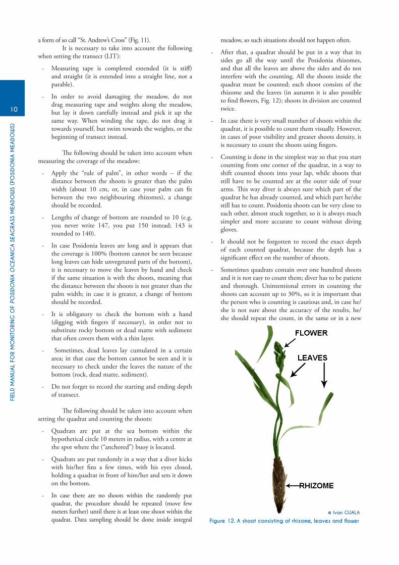
- After that, a quadrat should be put in a way that its sides go all the way until the Posidonia rhizomes, and that all the leaves are above the sides and do not interfere with the counting. All the shoots inside the quadrat must be counted; each shoot consists of the rhizome and the leaves (in autumn it is also possible to find flowers, Fig. 12); shoots in division are counted twice.
- In case there is very small number of shoots within the quadrat, it is possible to count them visually. However, in cases of poor visibility and greater shoots density, it is necessary to count the shoots using fingers.
- Counting is done in the simplest way so that you start counting from one corner of the quadrat, in a way to shift counted shoots into your lap, while shoots that still have to be counted are at the outer side of your arms. This way diver is always sure which part of the quadrat he has already counted, and which part he/she still has to count. Posidonia shoots can be very close to each other, almost stuck together, so it is always much simpler and more accurate to count without diving gloves.
- It should not be forgotten to record the exact depth of each counted quadrat, because the depth has a significant effect on the number of shoots.
- Sometimes quadrats contain over one hundred shoots and it is not easy to count them; diver has to be patient and thorough. Unintentional errors in counting the shoots can account up to 30%, so it is important that the person who is counting is cautious and, in case he/she is not sure about the accuracy of the results, he/she should repeat the count, in the same or in a new
Figure 12. A shoot consisting of rhizome, leaves and flower
© Ivan GUALA
FIEL
D M
ANUAL
FOR
MO
NIT
ORI
NG
OF
POSI
DONIA
OC
EANIC
A S
EAG
RASS
MEA
DOW
S (P
OSI
DONIA
MEA
DOW
S)
11
quadrat.
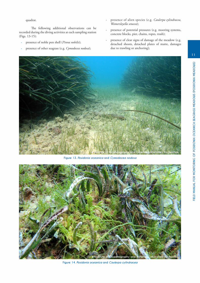
The following additional observations can be recorded during the diving activities at each sampling station (Figs. 13-15):
- presence of noble pen shell (Pinna nobilis);
- presence of other seagrass (e.g. Cymodocea nodosa);
- presence of alien species (e.g. Caulerpa cylindracea, Womersleyella setacea);
- presence of potential pressures (e.g. mooring systems, concrete blocks, pier, chains, ropes, trash);
- presence of clear signs of damage of the meadow (e.g. detached shoots, detached plates of matte, damages due to trawling or anchoring);
Figure 13. Posidonia oceanica and Cymodocea nodosa
Figure 14. Posidonia oceanica and Caulerpa cylindracea
© Institute of Oceanography and Fisheries, Laboratory for Benthos
© Institute of Oceanography and Fisheries, Laboratory for Benthos
FIEL
D M
ANUAL
FOR
MO
NIT
ORI
NG
OF
POSI
DONIA
OC
EANIC
A S
EAG
RASS
MEA
DOW
S (P
OSI
DONIA
MEA
DOW
S)
12
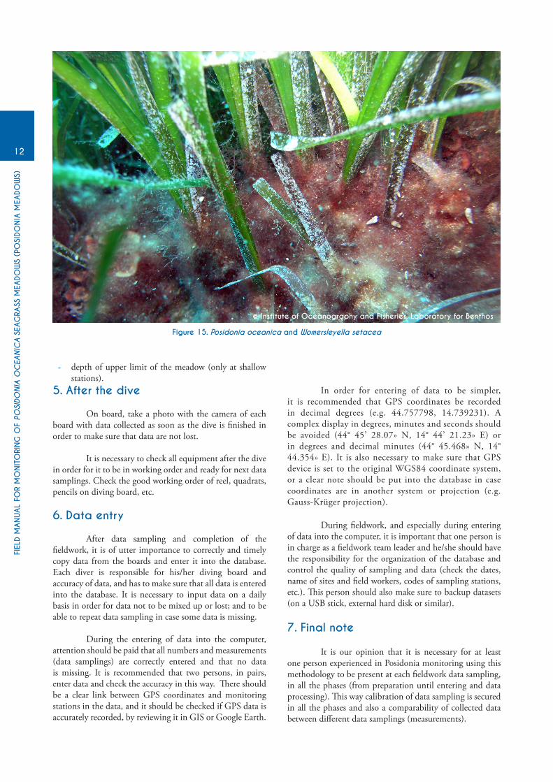
Figure 15. Posidonia oceanica and Womersleyella setacea
© Institute of Oceanography and Fisheries, Laboratory for Benthos
- depth of upper limit of the meadow (only at shallow stations).
5. After the dive
On board, take a photo with the camera of each board with data collected as soon as the dive is finished in order to make sure that data are not lost.
It is necessary to check all equipment after the dive in order for it to be in working order and ready for next data samplings. Check the good working order of reel, quadrats, pencils on diving board, etc.
6. Data entry
After data sampling and completion of the fieldwork, it is of utter importance to correctly and timely copy data from the boards and enter it into the database. Each diver is responsible for his/her diving board and accuracy of data, and has to make sure that all data is entered into the database. It is necessary to input data on a daily basis in order for data not to be mixed up or lost; and to be able to repeat data sampling in case some data is missing.
During the entering of data into the computer, attention should be paid that all numbers and measurements (data samplings) are correctly entered and that no data is missing. It is recommended that two persons, in pairs, enter data and check the accuracy in this way. There should be a clear link between GPS coordinates and monitoring stations in the data, and it should be checked if GPS data is accurately recorded, by reviewing it in GIS or Google Earth.
In order for entering of data to be simpler, it is recommended that GPS coordinates be recorded in decimal degrees (e.g. 44.757798, 14.739231). A complex display in degrees, minutes and seconds should be avoided (44° 45’ 28.07» N, 14° 44’ 21.23» E) or in degrees and decimal minutes (44° 45.468» N, 14° 44.354» E). It is also necessary to make sure that GPS device is set to the original WGS84 coordinate system, or a clear note should be put into the database in case coordinates are in another system or projection (e.g. Gauss-Krüger projection).
During fieldwork, and especially during entering of data into the computer, it is important that one person is in charge as a fieldwork team leader and he/she should have the responsibility for the organization of the database and control the quality of sampling and data (check the dates, name of sites and field workers, codes of sampling stations, etc.). This person should also make sure to backup datasets (on a USB stick, external hard disk or similar).
7. Final note
It is our opinion that it is necessary for at least one person experienced in Posidonia monitoring using this methodology to be present at each fieldwork data sampling, in all the phases (from preparation until entering and data processing). This way calibration of data sampling is secured in all the phases and also a comparability of collected data between different data samplings (measurements).

Regional Activity Centre for Specially Protected Areas (RAC/SPA)
Boulevard du Leader Yasser Arafat B.P. 337 - 1080 Tunis Cedex - TUNISIA Tel. : +216 71 206 649 / 485 / 765
Fax : +216 71 206 490 E-mail : [email protected]
www.rac-spa.org