Port Planning Texas City International Terminal - ABAM Planning Texas City International Terminal...
8
1 Port Planning Texas City International Terminal William L. Allen, PE, SE*; Christopher B. Cornell, PE, SE**; and Dr. Joseph Moseley, PE*** *Senior Project Manager, BERGER/ABAM Engineers Inc.; 33301 Ninth Avenue South, Federal Way, WA 98003-2600; Tel 206/431-2300, Fax 206/431-2250; [email protected] **Project Manager, BERGER/ABAM Engineers Inc.; 33301 Ninth Avenue South, Federal Way, WA 98003-2600; Tel 206/431-2300, Fax 206/431-2250; [email protected] ***Principal, Shiner/Moseley Associates, 555 N. Carancahua, Suite 1650, Corpus Christi, TX 78478; Tel 361/867-2211, Fax 361/857-7234; [email protected] Abstract For the past decade, the Galveston Bay area in Southeast Texas has experienced a sustained 6 percent annual growth in containerized cargo without a significant increase in cargo handling facilities. At present, existing regional container loading facilities are performing near ultimate capacity. There are numerous proposals to help alleviate the approaching congestion problems at the public port facilities. The Texas City International Terminal (TCIT) project is sponsored by the City of Texas City as a partial answer to sustained cargo growth in the region. The City of Texas City has formed a public/private partnership with TCIT for development and operation of a modern container terminal. The majority interest in TCIT is held by SSA Marine, a Seattle-based stevedoring company. In the early stages of program development, SSA initiated work on a concept development study conducted by BERGER/ABAM Engineers Inc. in an effort to identify the big picture elements associated with terminal development. The study was broken into three major tasks, including a market study, master planning, and an environmental assessment. Terminal planning was conducted parallel with the permit review process. This closely coordinated effort facilitated timely flow of information between the design team and regulatory and resource agencies. This allowed the design team to make midstream adjustments to the planning process in direct response to suggestions by agencies. This paper will discuss the key relationships between the design team and the public agencies. Purpose And Need Regional container traffic for the Galveston Bay area has been steadily increasing for many years. Container traffic for the Port of Houston has risen from approximately 538,000 20-foot equivalent units (TEUs) in 1992, to 1,159,000 TEUs in 2002. Container traffic has declined at the Port of Galveston from approximately 120,000 TEUs in 1992 to 43,000 TEUs in 2002 (Source: American Association of Port Authorities). The net result is a combined growth rate of approximately
Transcript of Port Planning Texas City International Terminal - ABAM Planning Texas City International Terminal...

1
Port Planning Texas City International Terminal
William L. Allen, PE, SE*; Christopher B. Cornell, PE, SE**; and
Dr. Joseph Moseley, PE***
*Senior Project Manager, BERGER/ABAM Engineers Inc.; 33301 Ninth Avenue South, Federal Way, WA 98003-2600; Tel 206/431-2300, Fax 206/431-2250; [email protected] **Project Manager, BERGER/ABAM Engineers Inc.; 33301 Ninth Avenue South, Federal Way, WA 98003-2600; Tel 206/431-2300, Fax 206/431-2250; [email protected] ***Principal, Shiner/Moseley Associates, 555 N. Carancahua, Suite 1650, Corpus Christi, TX 78478; Tel 361/867-2211, Fax 361/857-7234; [email protected]
Abstract For the past decade, the Galveston Bay area in Southeast Texas has experienced a sustained 6 percent annual growth in containerized cargo without a significant increase in cargo handling facilities. At present, existing regional container loading facilities are performing near ultimate capacity. There are numerous proposals to help alleviate the approaching congestion problems at the public port facilities. The Texas City International Terminal (TCIT) project is sponsored by the City of Texas City as a partial answer to sustained cargo growth in the region. The City of Texas City has formed a public/private partnership with TCIT for development and operation of a modern container terminal. The majority interest in TCIT is held by SSA Marine, a Seattle-based stevedoring company. In the early stages of program development, SSA initiated work on a concept development study conducted by BERGER/ABAM Engineers Inc. in an effort to identify the big picture elements associated with terminal development. The study was broken into three major tasks, including a market study, master planning, and an environmental assessment. Terminal planning was conducted parallel with the permit review process. This closely coordinated effort facilitated timely flow of information between the design team and regulatory and resource agencies. This allowed the design team to make midstream adjustments to the planning process in direct response to suggestions by agencies. This paper will discuss the key relationships between the design team and the public agencies.
Purpose And Need Regional container traffic for the Galveston Bay area has been steadily increasing for many years. Container traffic for the Port of Houston has risen from approximately 538,000 20-foot equivalent units (TEUs) in 1992, to 1,159,000 TEUs in 2002. Container traffic has declined at the Port of Galveston from approximately 120,000 TEUs in 1992 to 43,000 TEUs in 2002 (Source: American Association of Port Authorities). The net result is a combined growth rate of approximately
2
6 percent per year for the Galveston Bay area. Houston’s Barbours Cut Terminal has an existing ultimate sustainable annual capacity of just over 1.2 million TEUs. Galveston has an existing ultimate sustainable annual capacity of approximately 250,000 TEUs. With sustained annual regional growth of 4 to 6 percent, demand for the combined facilities will soon exceed capacity. The City of Texas City has obtained a permit for construction of a container terminal complex at Shoal Point. This paper will focus on the permitting and planning effort for the Texas City International Terminal at Texas City, Texas.
The City Dream At present, the majority of the local businesses in Texas City are centered around the petrochemical industry. In the early 1990s, the City of Texas City started exploring methods for diversifying their local economy. As part of that study, the City focused on the potential for developing a container terminal on Shoal Point. Shoal Point is an existing dredge material disposal site but, due to its proximity to the navigational channel, is ideally suited for development. In June 2000, the City entered in to a public/private agreement with TCIT, who would conduct an independent due-diligence process relative to development of the terminal. If the process was successful, TCIT would develop and operate the terminal on a build/operate/transfer ownership basis.
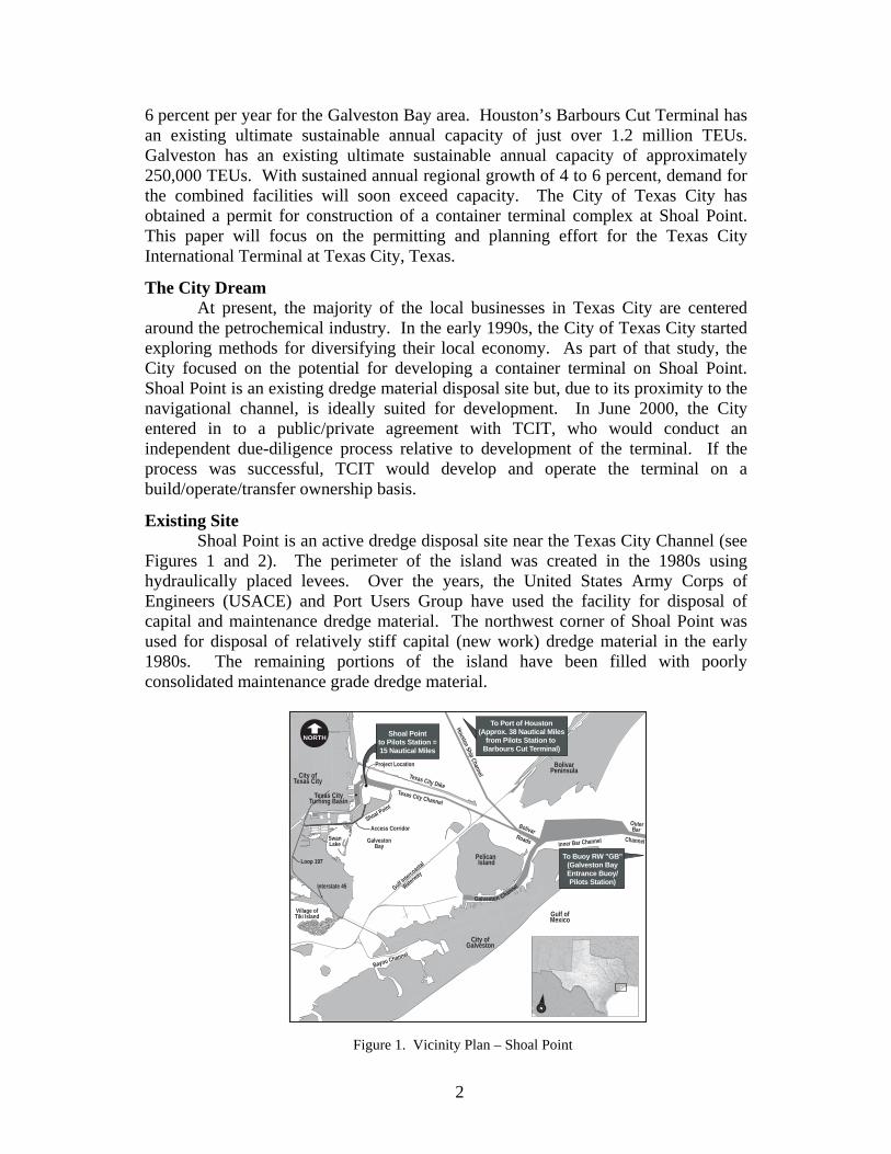
Existing Site Shoal Point is an active dredge disposal site near the Texas City Channel (see Figures 1 and 2). The perimeter of the island was created in the 1980s using hydraulically placed levees. Over the years, the United States Army Corps of Engineers (USACE) and Port Users Group have used the facility for disposal of capital and maintenance dredge material. The northwest corner of Shoal Point was used for disposal of relatively stiff capital (new work) dredge material in the early 1980s. The remaining portions of the island have been filled with poorly consolidated maintenance grade dredge material.
Shoal Pointto Pilots Station =15 Nautical Miles
To Port of Houston(Approx. 38 Nautical Miles
from Pilots Station to Barbours Cut Terminal)
Village ofTiki Island
Texas City DikeTexas City Channel
Inner Bar Channel
Houston Ship Channel
City ofGalveston
Gulf ofMexico
Pelican Island
GalvestonBay
Gulf Intercoastal
Waterway
Bayou Channel
Shoal Point
Project Location
Access Corridor
SwanLake
Bolivar Roads
OuterBar
Channel
BolivarPeninsula
Galveston Channel
To Buoy RW "GB"(Galveston BayEntrance Buoy/Pilots Station)
City ofTexas City
Interstate 45
Loop 197
Texas CityTurning Basin
NORTH
Figure 1. Vicinity Plan – Shoal Point

3
Conceptual Design In the early stages of the program, TCIT initiated work on a concept development study for the project. The primary focus of this study was to identify the big picture elements associated with development and operation of the facility. An independent market study was initiated by SSA Marine. The site development study was performed by BERGER/ABAM Engineers Inc. as prime consultant, with Fugro South, Shiner/Moseley and Associates, and J.E. Chance as subconsultants to the team. As part of the site study effort, the consulting team investigated numerous issues that may affect the constructability of the port complex. BERGER/ABAM conducted the port planning activity. Geotechnical exploration and analysis was performed by Fugro South. Wetland mapping was conducted by Shiner/Moseley, and aerial and bathymetric mapping were performed by J.E. Chance. In addition, the City contracted to have property mapping performed for the site. As a starting point, the design team put together some fundamental site layouts based on a hypothetical cargo stream. From this, the design team assembled a suite of site alternatives for consideration by TCIT. At that juncture, the City made a formal permit application to USACE. The permit application included the build-out concept (see Figure 3) for the proposed terminal consisting of the following.
1,830-meter (6,000-foot) marginal wharf for six berth positions 6.9 million cubic meters (9 million cubic yards) capital dredging at the
berth position Deepening the existing 13 km Texas City channel to a depth of -
13.7 meters (-45 feet) COE MLT Creating a new navigational turning basin 162-hectare (400-acre) container yard 5.6-km (3.5-mile) access roadway
Figure 2. Aerial view of existing Shoal Point showing two active disposal cells and one decommissioned cell
(vegetated).

4
Permitting Process The permitting process started in earnest by mid-summer of 2000. USACE had a formal project scoping notice by the fall of 2000, which resulted in a finding that an environmental impact statement (EIS) process was required. The scoping process identified several areas of concern, including the requirement for a new dredge material management plan (DMMP), a navigation study, a land traffic study, and a thorough review of air quality issues associated with construction and operation of the facility. The firm of PBS&J was selected as the EIS consultant. With their guidance, a host of stakeholder subcommittees were formed to discuss and resolve many of the key issues for inclusion in the EIS. From the very beginning, the project sponsor took a proactive approach to conflict resolution in order to better understand and address the concerns of the numerous stakeholders in the project. By involving all of the stakeholders from the beginning, there was a clear vehicle for each of these stakeholders to be part of the planning activity. All of the subcommittees included project staff members from the City of Texas City, TCIT, USACE, and PBS&J.
Dredge Material Management Plan Shoal Point is an existing upland disposal site that is operated by USACE and the City of Texas City, as local sponsor. With permitting and construction of the proposed container terminal, the existing dredged material disposal capacity of Shoal Point was significantly reduced. This reduction of reserve capacity (estimated at 25 years without the terminal) forced the need to develop a new 50-year DMMP which would address the dredge disposal needs of the applicant, and the needs of future maintenance dredging in the channel. The DMMP subcommittee was composed of project staff and representatives from the Texas City Port Users Group, National Marine Fisheries, U.S. Fish and Wildlife Service, Texas Commission for
Figure 3. Six-berth marginal wharf with 162-hectare container stacking yard.

5
Environmental Quality (TCEQ), Texas Parks and Wildlife, Texas General Land Office, and other nongovernment stakeholders, including the Galveston Bay Foundation and the Coast Conservation Association. A wide range of disposal options were developed that included continued upland disposal on an enlarged version of Shoal Point, off-site disposal, and creation of beneficial use sites that will ultimately be converted to intertidal habitat. After considerable effort, the subcommittee adopted a 50-year plan that included continued upland disposal on the undeveloped portions of Shoal Point in combination with creation of approximately 546 hectares (1,350 acres) of beneficial use sites. Results of the study were published and were included by reference in the EIS and the permit application. (see Figure 4). Wetland mitigation for the terminal is a small 18-hectare (45-acre) parcel near the north edge of Swan Lake. Mitigation for lost disposal capacity on Shoal Point included construction of levees for the 144-hectare (357-acre) Shoal Point Beneficial Use Site No. 1 (SPBUS1)
Navigation The Navigational Subcommittee was composed of project staff, plus representatives from the U.S. Coast Guard, the Galveston Bay Pilot’s Association (vessels), tug and barge services, and interested members of the Texas City Port Users Group. The primary focus of this activity was to rationalize the utilization of the navigational channel in the context of introducing container vessels into the existing and forecasted barge and vessel traffic streams. The task included a queue and delay analysis along with a conflict analysis. Results from the study suggested there was no need to widen the channel to accommodate two-way traffic. However, a new turning basin was required for Phase 2 implementation of the container terminal in order to address the potential for turning the larger post-Panamax vessels as the container fleet matures.
PA2-PA4I IIIII
BerthingArea
SPBUS2SPBUS2
SPBUS1SPBUS1
PA5PA5
PA6PA6 SPBUS3SPBUS3
PBUSPBUS
SPBUS4SPBUS4
SPBUS5SPBUS5
SPBUS2
SPBUS1
PA5
PA6 SPBUS3
PBUS
SPBUS4
SPBUS5
City ofTexas City
Texas CityTurning Basin
Texas City DikeTexas City Channel
Houston Ship Channel
Pelican Island
GalvestonBay
New BeneficialUse Cells
Gulf Intra
coastal
Waterway
Project Location
Access Corridor
SwanSwan
LakeLake
TurningBasin
Swan
Lake
Figure 4. Fifty-year dredge material management plan.

6
Traffic The Traffic Subcommittee was composed of project staff and representatives from Federal Highway Administration (FHWA), Texas Department of Transportation (TxDOT), Houston Greater Area Council (HGAC), Texas City Port Users Group, and adjacent land holders. The primary focus of this activity was to perform traffic modeling in order to determine the effects the terminal operation would have on the existing and planned highway network in the region. The regional model (provided by HGAC) extended as far north as the central business district of Houston. Results of the analysis suggested that some of the existing roadway components and intersections were adversely affected by introduction of additional truck traffic into the network. Most of the impacts were a considerable distance from the terminal and would be addressed in the future by state and local agencies. Some of the results of the traffic analysis were also exported and used by the Air Quality Subcommittee.
Air Quality The Air Quality Subcommittee was composed of project staff and representatives from JD Consulting, TxDOT, HGAC, and TCEQ. The greater Houston region is in an Environmental Protection Agency nonattainment area for air quality compliance. As such, there are increased sensitivities and requirements regarding emissions, both for construction and operation. The Air Quality Subcommittee created a model that evaluated emissions generated during construction and operation in an effort to determine the impacts associated with the project. Analysis suggested that the project would generate excessive air emissions during initial construction of the project using traditional construction methods. Based on this analysis, the project applicants agreed to perform capital dredging using a nontraditional shore-powered electric dredger for the work. By doing this, the applicant was able to mitigate the concerns regarding air quality.
Site Planning At buildout, the container terminal facility will be composed of six berth positions for a total of 1,830 meters (6,000 feet) of berthing, plus a 162-hectare (400-acre) container yard facility. Ships will be serviced with post-Panamax class gantry cranes. Containers will be stacked in blocks that are modular with the berth positions. Yard handling equipment will include rubber-tired gantries (RTGs), side picks, and top picks. Movements within the terminal area will be accommodated using bomb carts and chassis. The terminal operator provided the operational requirements for the facility. The design team used this input in combination with the cargo forecast to develop the final layout. In general, the analysis segregated the cargoes as empty containers, export loads, and import loads, with special considerations for refrigerated containers. Each of these cargoes were analyzed independently using appropriate dwell times and stacking heights in order to develop a comprehensive overall site arrangement for the facility. At buildout, the yard will have a combined total of approximately 26,300 grounded slots for the operation. There is additional space provided for chassis storage and circulation. This results in an approximate maximum sustainable throughput of 1.9 million TEUs per year, and ultimate throughput of 2.4 million TEUs per year.

7
There are four major buildings within the facility including an administration building, maintenance building, crane maintenance building, and an electrical distribution building. There are a host of other miscellaneous buildings, including terminal lunch and break rooms, security, and pump room for domestic water supply. The gate structures have been designed as a dedicated inbound gate and a dedicated outbound gate. Staffing for the gate operations will be centralized within the administration building. At buildout, the gates will be required to handle approximately 2.6 million movements per year, with an average daily transaction rate of 330 movements per working day per gate. In general, there is considerable infrastructure in the vicinity of the project site that can be utilized to support the terminal activities. There is a four-lane highway (Loop 197) near the site that has almost direct connections to the interstate highway system. In addition, there is existing rail service at the Texas City Terminal Railway Company that may be utilized in the future should there be sufficient cargo volume to justify an off-terminal intermodal facility. Loop 197 is approximately 5.6 kilometers (3.5 miles) from the planned terminal. The design team identified a preferred access corridor from the highway to the terminal that is primarily a traditional earthen roadway template, but required approximately 1 mile of sheet pile bulkhead adjacent to the Gulf Coast Waste Disposal Facility. As part of this study, the design team performed a hydraulic analysis for the existing hurricane canal adjacent to the access road to ensure there were no adverse impacts to hydraulic performance of the feature that resulted from the wall construction. The roadway has been designed as a dedicated four-lane industrial road to support movement of up to 11,000 truck trips per day at buildout. Shoal Point has very good access to the existing Texas City Channel. As such, there are minimal requirements for dredging additional channel. The project does envision the need for deepening the channel to -13.7 meters (-45 feet) from the present -12.2 meters (-40 feet). The design team worked closely with the Galveston Bay Pilot’s Association in order to develop a rational strategy to address navigational issues associated with the proposed terminal adjacent to an already busy navigational channel. Discussions suggested that a separate turning basin would be required in the future should the larger post-Panamax class vessel start calling at the terminal.
Phased Implementation The proposed terminal will likely be constructed in phases dictated by the flow of cargo through the facility. The initial phase of construction will include construction of the access corridor, the electrical supply and distribution system, and the majority of the support buildings such as administration, maintenance, and electrical distribution buildings. The yard will consist of approximately 50.6 hectares (125 acres) of open storage container yard, immediately behind a two berth 610-meter (2,000-foot) marginal wharf. That facility will sustain approximately 500,000 TEUs per year throughput. Phase 2 will likely include the addition of two more berths and 50.6 hectares (125 acres) of storage yard for a combined sustained throughput capacity of 800,000 TEUs per year. Phase 3 construction will add two more berths and 60.7 hectares (150 acres) of storage yard. At buildout, the facility will have 1,830 meters (6,000
8
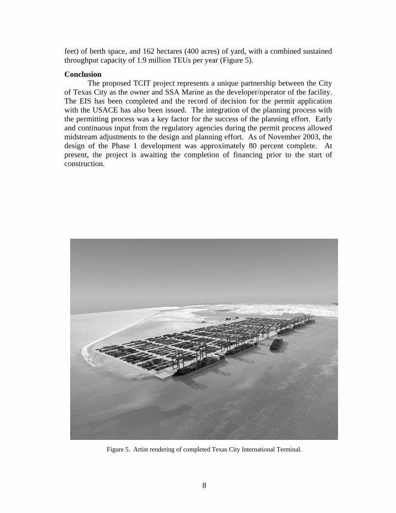
feet) of berth space, and 162 hectares (400 acres) of yard, with a combined sustained throughput capacity of 1.9 million TEUs per year (Figure 5).
Conclusion The proposed TCIT project represents a unique partnership between the City of Texas City as the owner and SSA Marine as the developer/operator of the facility. The EIS has been completed and the record of decision for the permit application with the USACE has also been issued. The integration of the planning process with the permitting process was a key factor for the success of the planning effort. Early and continuous input from the regulatory agencies during the permit process allowed midstream adjustments to the design and planning effort. As of November 2003, the design of the Phase 1 development was approximately 80 percent complete. At present, the project is awaiting the completion of financing prior to the start of construction.
Figure 5. Artist rendering of completed Texas City International Terminal.