![Google docs[1] by Claire Pollok](https://static.fdocuments.in/doc/165x107/547f6e07b4af9fa7368b4afd/google-docs1-by-claire-pollok.jpg)
POLLOK PARK - Glasgow
78
POLLOK PARK conservation area appraisal 2016
Transcript of POLLOK PARK - Glasgow

POLLOK PARKcon
servation
area app
raisal
2016

Executive Director: Richard BrownDevelopment and Regeneration ServicesGlasgow City Council229 George StreetGLASGOW G1 1QU
© Text: copyright Glasgow City Council, 2015.© Images: copyright Nick Haynes, 2015 unless otherwise credited.

Prepared by Nick Haynes & AssociatesBased on initial drafts by the Heritage & Design Team, Glasgow City CouncilSurvey work undertaken Autumn 2014
Consultant TeamNick Haynes, MA (Hons), IHBCVanessa Stephen, BA (Hons), CMLIDeborah Mays, MA (Hons), PhD, Hon FRIAS, FRSA, FSA (Scot), IHBC
POLLOK PARKCONSERVATION AREA APPRAISAL
Cover imagesBackground: Pollok House.Top detail: lion sculpture, North Gate.Middle detail: Pollok House garden.Bottom detail: Burrell Museum.
Frontispiece (overleaf)Detail of the lion nial on the North Gate, carved by John Marshall from a model by Hew Lorimer, 1950.
2016
PDF EDITIONSection and sub-section headings are tagged in the index (click on the text to navigate to the page). Clicking on the coloured side-tabs on each page returns the reader to the index. Hyperlinks to websites outside the document can be activated by clicking.


DRS/2014 /1
INTRODUCTIONLocation ..........................................................................................3
Conservation Areas .......................................................................3
What Does Conservation Area Status Mean? .............................3
Purpose of a Conservation Area Appraisal ................................4
Using this document ......................................................................4
PRESERVATION & ENHANCEMENTIntroduction ................................................................................. 58
Management Planning .............................................................. 58
Opportunities for Preservation and Enhancement ................. 59
PART ONE: HISTORY, CHARACTER & APPEARANCE
HISTORICAL DEVELOPMENTPlace Names ................................................................................ 5
Baronets and Baronetess of Pollok ............................................. 5
General History of Buildings and Structures ............................... 8
History of Landscape.................................................................. 22
PARKSCAPE APPRAISALPollok House & Designed Landscape ..................................... 32
Topography ................................................................................. 32
Open Space ................................................................................ 32
Views & Landmarks .................................................................... 34
Activities/Uses ............................................................................. 37
Architectural Character ............................................................. 38
Landscape Character ................................................................ 40
Hydrology .................................................................................... 44
Building Materials ....................................................................... 44
Condition ..................................................................................... 45
CHARACTER ASSESSMENTIntroduction ................................................................................. 47
Assessment of Buildings & Spaces ............................................ 47
Conservation Area boundary ................................................... 49
Sites of Importance for Nature Conservation .......................... 49
Green Corridor ............................................................................ 49
Sites of Special Landscape Importance .................................. 49
KEY FEATURESKey Features ............................................................................... 51
KEY CHALLENGESKey Challenges .......................................................................... 52
CONSERVATION AREA BOUNDARIESBoundary History......................................................................... 55
Boundary Amendments ............................................................. 55
PART TWO: PRESERVATION & ENHANCEMENT
PART THREE: GENERAL INFORMATION
CONTENTS
GRANTSRepair Grants .................................................................................64
CITY PLANPolicies............................................................................................64
ARTICLE 4 DIRECTIONSArticle 4 Directions in Pollok Park Conservation Area ...............65
BIBLIOGRAPHY & REFERENCESSelect Bibliography .......................................................................66
Useful Websites ..............................................................................66
FURTHER INFORMATIONUseful Contacts ..............................................................................68
Useful Publications .........................................................................68
*Addendum – This page has been amended to show all current Article 4 Directions
Permitted Development) (Scotland) Order 1992))
*

POLLOK PARK
conservation area appraisal
2/DRS/2015
Introduction
INTRODUCTION
1Contains Ordnance Survey data © Crown copyright and database right, 2015
INTRODUCTION

POLLOK PARK
cons
erva
tion
area
app
rais
al
DRS/2015 /3
Intr
oduc
tionLocation
Pollok Park Conservation Area comprises much of the former country estate associated with Pollok House. It is located about 4km south-west of Glasgow City Centre. The area is largely enclosed by the M77 on the north and west, by the B768 and B769 on the north and east, and by the Glasgow-Barrhead-Kilmarnock railway on the south and east. A small area of greenspace at Corkerhill extends west of the M77. Local communities around the conservation area include Mosspark and Bellahouston to the north, Pollokshields, Dumbreck, Titwood, Shawlands and Pollokshaws to the east, Mansewood, Kennishead and Carnwadric to the south, and Darnley, Priesthill, Househillwood, Pollok and Corkerhill to the west (see Figure 1). Pollok Park Conservation Area touches the boundary of West Pollokshields Conservation Area to the north-east.
Pollok Country Park, which is owned and managed by Glasgow City Council, forms the core of the conservation area. Pollok House and the Burrell Collection are located here. Other buildings and landholdings associated with the old country estate, including Pollok Golf Course, Cowglen Golf Course and Haggs Castle Golf Course, also lie within the wider conservation area.
Conservation Areas
the Civic Amenities Act 1967. The Planning (Listed Buildings and Conservation Areas) (Scotland) Act 1997 provides the current legislative framework for the designation of Conservation Areas.
“an area of special architectural or historic interest, the character or appearance of which it is desirable to preserve or enhance”.
All planning authorities are required by this Act to determine which parts of their area merit Conservation Area status. Glasgow currently has 25 Conservation Areas varying in character from the city centre and Victorian residential suburbs to a rural village and former country estate.
1. Map of the boundaries of Pollok Park Conservation Area.
2. General aerial view of Pollok House, Stables and Walled Gardens from the south-east. © Crown copyright: RCAHMS (Ref. DP0015666). Licensor: www.rcahms.gov.uk.
What Does Conservation Area Status Mean?
In a Conservation Area it is both the buildings and the spaces between them that are of architectural or historic interest. Planning control is therefore directed at maintaining the integrity of the entire area and enhancing its special character. Conservation Area status does not mean that new development is unacceptable, but care must be taken to ensure that the new development will not harm the character or appearance of the area.
Under current legislation, Conservation Area designation automatically brings the following works under planning control:
• Demolition of buildings
2
• Removal of, or work to, trees
• Development involving small house extensions, roof alterations, stone cleaning or painting of the exterior, provision of hard surfaces, and
• Additional control over satellite dishes.
Where a development would, in the opinion of the planning authority, affect the character or appearance of a Conservation Area, the application for planning permission will be advertised in the local press providing
INTRODUCTION

POLLOK PARK
conservation area appraisal
4/DRS/2015
Introduction
of the key features that together create the area’s special character and appearance.
The purpose of this appraisal is to define and evaluate the character and appearance of the area, to identify its important characteristics and ensure that there is a full understanding of what is worthy of preservation. The area’s special features and changing needs will be assessed through a process that includes researching its historical development, carrying out a detailed townscape analysis and preparing a character assessment.
The study will provide an opportunity to reassess the current Conservation Area boundaries to make certain that they accurately reflect what is of special interest and to ensure that they are logically drawn. It will also identify opportunities for preservation and enhancement and provide a basis for the development of the next stage in the process – the preparation of a Conservation Area management plan.
This finalised version of the appraisal (following public consultation on an earlier draft appraisal) will be regarded as supplementary to the policies set out in the
1
an opportunity for public comment. Views expressed are taken into account by the local planning authority when making a decision on the application.
In order to protect the Conservation Areas, designation requires the City Council to formulate and publish proposals for their preservation and enhancement.
Local residents and property owners also have a major role to play in protecting and enhancing the character and appearance of the Conservation Area by ensuring that properties are regularly maintained and original features retained.
Purpose of a Conservation Area Appraisal
Conservation Area designation should be regarded as the first positive step towards an area’s protection and enhancement.
Planning authorities and the Scottish Government are required by law to protect Conservation Areas from development that would be detrimental to their character. It is necessary therefore for planning authorities, residents and property owners to be aware
2
adopted City Plan 2 (2009) and have the status of a ‘material consideration’ in the assessment of development proposals.
It is recognised that the successful management of Conservation Areas can only be achieved with the support and input from stakeholders, and in particular local residents and property owners.
Using this document
This Appraisal is divided into three parts.
PART ONE examines the history, character and appearance of the Conservation Area. Within the overall Conservation Area, four local Character Areas are identified.
PART TWO identifies the management issues within the Conservation Area, including challenges and potential for preservation and enhancement measures.
PART THREE contains general information including a bibliography, useful websites and contacts.
INTRODUCTION

POLLOK PARK
cons
erva
tion
area
app
raisa
l
DRS/2015/5
His
toric
alD
evel
opm
ent
Baronets and Baronetess of Pollok
John Maxwell, 1st Bt, 1648-1732
John Maxwell, 2nd Bt, 1686-1752
John Maxwell, 3rd Bt, 1720-58
Walter Maxwell, 4th Bt, 1732-62
John Maxwell, 5th Bt, 1761-62
James Maxwell, 6th Bt, 1735-85
John Maxwell, 7th Bt, 1768-1844
John Maxwell, 8th Bt, 1791-1865
William Stirling Maxwell, 9th Bt, 1818-78
John Stirling Maxwell, 10th Bt, 1866-1956
Anne Maxwell Macdonald, 11th Btss, 1906-2011
John Ronald Maxwell Macdonald, 12th Bt
1. A decorative urn.2. White Cart Bridge, built in 1757-58.3. Sir John Maxwell, 2nd Baronet, who built
the classical mansionhouse between 1747 and 1752. He inherited the Nether Pollok Estate from his cousin in 1732. Reproduced from www.theglasgowstory.com with the permission of Sir John Maxwell Macdonald.
4. Sir William Stirling Maxwell, 9th Baronet. William Stirling of Keir adopted the Maxwell name on inheriting Pollok from his uncle in 1865. He had a strong interest in Spanish art, and built up the noted collection now on display in Pollok House. Image from Maxwell’s ‘Miscellaneous Essays & Addresses’ of 1891.
5. Sir John Stirling Maxwell, 10th Baronet, who commissioned Robert Rowand Anderson to add the wings to the house and remodel the terrace gardens. Sir John was an MP and chairman of several national institutions including the Forestry Commission, the Ancient Monuments Board and the Royal Fine Art Commission for Scotland and a founder member in 1931 (and later President) of the National Trust for Scotland. By permission of the University of Glasgow.
PART ONE: HISTORY, CHARACTER & APPEARANCE
3 54
Place Names
The land now occupied by Pollok Country Park was first widely known as ‘Nether Pollok’. It was originally part of the Barony of Mearns in Renfrewshire. ‘Nether’ means ‘lower’ and ‘Pollok’ is thought to derive from the Gaelic word, ‘pollag’, which means ‘small pond’.
Before the current spelling was firmly established in the nineteenth century, there were a number of variants of Pollok including: Pouak (Timothy Pont map, before 1614); Pouck (Johannes Blaue map, 1654); Powok (Robert Gordon map, 17th century); Polluck (John Adair map, 1685); Polloc, Pollock (Roy map, 1755). ‘Pollok’ is used throughout this text.
The Maxwell family consolidated a number of the surrounding lands into the Nether Pollok Estate between the sixteenth and eighteenth centuries. The current study area includes the old lands of Knowehead, Lochinch, Lochdam, Damshot, Haggs, Sheeppark, Cowglen, Pollokhead, Kennishead and Corkerhill.
HISTORICAL DEVELOPMENT
PART ONE: HISTORY, CHARACTER & APPEARANCE

POLLOK PARK
conservation area appraisal
6/DRS/2015
Historical
Developm
ent
1
2
PART ONE: HISTORY, CHARACTER & APPEARANCE

POLLOK PARK
cons
erva
tion
area
app
raisa
l
DRS/2015/7
His
toric
alD
evel
opm
ent
3
1. Detail from Map 33 of Renfrewshire, by Timothy Pont ca. 1583–1601 showing ‘N:Pollok’. ‘Hags’ and ‘Krukstoun’ castles are the main features of the locality at this time. Reproduced by permission of the National Library of Scotland.
2. Detail from Robert Ogilvy’s 1741 Pollok Estate Plan. Image supplied by the Mitchell Library and reproduced by permission of Sir John Maxwell Macdonald.
3. Detail from General Roy’s Military Map of Scotland, 1747–55 that indicates the agricultural nature of the ‘Nether Pollock’ estate. The house appears to have been located where the stables now stand, and adjoined large walled compartments. A small farm town marked as ‘Pollock’, stood to the south of the White Cart Water. © The British Library. Licensor: www.scran.ac.uk.
4. Detail from a Map of the Town of Glasgow and Country 7 Miles Around by Thomas Richardson, 1795. Nether Pollock House is now shown in its current location, set in a small formal landscape of avenues, and the village is no longer marked. Reproduced by permission of the National Library of Scotland.
4
PART ONE: HISTORY, CHARACTER & APPEARANCE

POLLOK PARK
conservation area appraisal
8/DRS/2015
Historical
Developm
ent
History
The following sections review the current state of knowledge about the estate from the earliest times through to the present day. More detailed information can be found in the bibliography and online resources set out in Part Three of this appraisal. Work by Stephen Driscoll and Mark Mitchell (Glasgow Archaeological Society) and Stuart Nisbet on the early history of the estate is ongoing.
The general history of the buildings and structures is followed by the history of the planting and landscape development.
General History of Buildings and Structures
Earliest history
The earliest record of human habitation in Nether Pollok is at Law Hill in the form of a prehistoric burial mound now covered by a roundel of planting. It is sited south of the White Cart Water, on Pollok Golf Course (NS 5460 6164).
The earthwork on the crest of an elongated hill (NS 5566 6263) in what is now North Wood comprises a roughly circular enclosure some 30m in diameter,
surrounded by a deep ditch 9m wide, interrupted on the east side by a stone-paved causeway, 5m in width. Excavations of 2007 suggest that the structure is an Iron Age hillfort. There are traces of inner and outer banks formed by upcast from the ditch. An in situ hearth was discovered, which provided a suitable charcoal sample for dating purposes (300 BCE).
There was a strong association between Pollok and St Conal prior to the twelfth century. St Conal or Convallus was an Irish saint who taught Christianity in the 7th century. A well close to the main entrance to the current mansion house was dedicated to
Iron Age Earthwork
Law Hill Burial Mound
Second Castle Site
First Castle and Laighe CastleOld Pollok Toun
Contains Ordnance Survey data © Crown copyright and database right, 2015
Pollok House
Burrell Collection
PART ONE: HISTORY, CHARACTER & APPEARANCE

POLLOK PARK
cons
erva
tion
area
app
raisa
l
DRS/2015/9
His
toric
alD
evel
opm
ent
St Conal, and a walled enclosure containing a ruined building known as St Conal’s Dowry was reported to have stood near the ancient parish church of Pollok on the banks of the White Cart Water (Scott, 1920, p.133). The parish church moved to Eastwood in the fourteenth century, but the old church may have continued to exist at Pollok as a chapel.
Mediaeval
In 1124 King David I granted the lands of Pollok to Walter FitzAllan (1106-77), the High Steward of Scotland. The grant was confirmed by his grandson, Malcolm IV, in 1157-58, through an Act of Parliament. Peter of Pollok was gifted the lands of Pollok and ‘Mernis’ by at the end of the twelfth century. Upper Pollok comprises what is now Newton Mearns.
By the early thirteenth century the lands of Pollok were being managed for agriculture, and there were religious and secular developments along the river, including a tower house or keep. The main concentration of this is thought to be in the vicinity of the White Cart Water.
In the early thirteenth century Roland of Mearns (or McGauchen) owned the lands
of Pollok and the estates of Nether and Upper Pollok. His descendent, Mary, married Sir Aymer Maxwell of Caerlaverock (circa 1190-1266). Sir Aymer gave Nether Pollok to his third son, Sir John Maxwell (1243-1306). Sir John is traditionally referred to as the first knight of Pollok. Sir John’s acquisition of Nether Pollok saw its continued development as a trading and administrative centre. It is suggested that the barony court for Pollok was held at ‘Law Bush’ or ‘Law Hill’. He may have been responsible for the earliest castle on the site of the later stable courtyard.
The remnants of a well-defined mediaeval causeway, which ran from the south side of the River Cart over the ford in front of Pollok House up through the Deerpark and past the Burrell Collection, have been found in recent years by archaeologists from the University of Glasgow (NS 552 624).
There is a less distinctive mediaeval ring-work located in the North Wood (NS555624), south of the Iron Age fort, largely over-ploughed. This consisted of an earthen bank and boundary bank and ditch which enclosed the area of a late mediaeval farmstead, predominantly fourteenth to sixteenth century in date. It contains the remains of a post-mediaeval rectangular building of seventeenth to eighteenth
1. Map of selected ancient features.2. View of the Iron Age earthwork in North
Wood.
century date.
During the fourteenth century the Maxwells continued to increase control over Pollok. They replaced the earlier tower house on the White Cart Water with one on higher ground to the north of the river (known as the Second Castle). This may be dated to 1367 or 1368, the year of the marriage of Sir John Maxwell and Isabella Lindsay, because their armorial bearings were found among the ruins. Its positioning on higher ground was probably intended to make it more defensive and to raise it above the area of flooding at the previous site (and source of the name ‘pollag/Pollok/pond’).
William Semple (The History of the Shire of Renfrew, 1782) records that Sir John Maxwell, 3rd baronet, demolished the Second Castle (presumably what was left) when building the new mansion sometime between 1737 and 1752. At the end of the nineteenth century, little of the foundations could be traced (Mitchell and Smith, 1878).The existing beech tree (planted 1759) on a formal mound marks the supposed site within the Woodland Garden. A magnetometer and topographic survey in 2009 revealed no traces of structures at the mound, but some possible associated features were detected further east.
The third castle, the ‘Laighe Castle’ (low castle), was built partially on the site and ruins of the original castle beside the White Cart Water, or incorporated within the remains of it. It was used as a dower or jointure house (provided for the lifetime’s use of a widow). This Laighe Castle continued to be one of the residences of the family until 1747 when some of its fabric was incorporated by the 3rd Baronet into the new stable courtyard. Parts of the castle can be seen notably in the east wall of the courtyard and the west entrance.
PART ONE: HISTORY, CHARACTER & APPEARANCE

POLLOK PARK
conservation area appraisal
10/ DRS/2015
Historical
Developm
ent
The extent of castle building at Pollok suggests that the surrounding landscape was developed simultaneously for agriculture and as gardens. Early fabric to
current walled garden, awaits more detailed archaeological investigation to support this thesis.
The settlement known as ‘Polloktoun’, was situated on the south bank of the White Cart Water, opposite the Stables. It was also known as ‘Nether Pollok town’ or ‘Neddes Pollok’.
Renaissance
During the sixteenth century the Maxwells consolidated their land holdings at Pollok, acquiring Haggs, Cowglen and Pollokshaws. The Second Castle may have been abandoned in favour of the Laighe Castle after the addition of a tower in about
1518.
Sir John Maxwell of Cowglen’s allegiance to Queen Mary at the Battle of Langside in 1568 resulted in a brief seizure of the lands of Nether Pollok by the Crown. Sir John Maxwell of Cowglen died in 1577, leaving the liferent of the Nether Pollok estate to his wife, Elizabeth. This arrangement was to prove a constant source of tension between Lady Elizabeth and Sir John’s eldest son and heir, the 12th Laird of Pollok, also called John Maxwell. In 1578 Lady Elizabeth complained to the Privy Council that her son had raided the Laighe Castle, and three years later Sir John alleged that his mother had let the tower, fortalice and manor-place of Nether Pollok ‘rot and decay for want of repairs’ and cut the woods, orchards and yards (produce gardens) ‘to the utter destruction and desertion of the place’ (Fraser, 1863). This family feud was probably the main motivation for Sir John
and his wife, Margaret Conyngham, to construct a new house on the neighbouring lands of Haggs in 1585-7. Haggs Castle, built by the mason Robert Boyd, still survives just outside the conservation area.
that Pollokhead Wood was in existence as managed woodland by this time and that it was then transferred into the possession of Margaret Maxwell, daughter of Sir John Maxwell.
A new entrance to the Laighe Castle was made in the seventeenth century (M’Callum, 1925). This was subsequently incorporated to serve as the entrance to the present stable courtyard.
1
2
3
PART ONE: HISTORY, CHARACTER & APPEARANCE
The extent of castle building at Pollok suggests that the surrounding landscape was developed simultaneously for agriculture and as gardens. Early fabric to current walled garden, awaits more detailed archaeological investigation to support this thesis.
The settlement known as ‘Polloktoun’, was situated on the south bank of the White Cart Water, opposite the Stables. It was also known as ‘Nether Pollok town’ or ‘Neddes Pollok’.
Renaissance
During the sixteenth century the Maxwells consolidated their land holdings at Pollok, acquiring Haggs, Cowglen and Pollokshaws. The Second Castle may have been abandoned in favour of the Laighe Castle after the addition of a tower in about 1518.
Sir John Maxwell of Cowglen’s allegiance to Queen Mary at the Battle of Langside in 1568 resulted in a brief seizure of the lands of Nether Pollok by the Crown. Sir John Maxwell of Cowglen died in 1577, leaving the liferent of the Nether Pollok estate to his wife, Elizabeth. This arrangement was to prove a constant source of tension between Lady Elizabeth and Sir John’s eldest son and heir, the 12th Laird of Pollok, also called John Maxwell. In 1578 Lady Elizabeth complained to the Privy Council that her son had raided the Laighe Castle, and three years later Sir John alleged that his mother had let the tower, fortalice and manor-place of Nether Pollok ‘rot and decay for want of repairs’ and cut the woods, orchards and yards (produce gardens) ‘to the utter destruction and desertion of the place’ (Fraser, 1863).This family feud was probably the main motivation for Sir John

POLLOK PARK
cons
erva
tion
area
app
raisa
l
DRS/2015/11
His
toric
alD
evel
opm
ent
1. Remnants of the sixteenth-century Laighe Castle incorporated into the north-west corner of the current stable courtyard.
2. The 14th-century arms of Sir John Maxwell and Isabella Lindsay from William Fraser’s ‘Memoirs of the Maxwells of Pollok’, 1863.
3. Four worn stones from the 14th-century arms of Sir John Maxwell and Isabella Lindsay, set into a panel above the gateway to the stable court.
4. A 17th-century gateway incorporated into the west side of the stable courtyard in the late 18th century.
5. Detail from Robert Ogilvy’s 1741 Pollok Estate Plan. Image supplied by the National Trust for Scotland and reproduced by permission of Sir John Maxwell Macdonald.
Eighteenth Century
In 1708, 244 ‘examinable persons’ were recorded in Polloktoun and in Robert Ogilvy’s plan of 1741, 36 houses and gardens are shown arranged along several streets with the primary axis leading across the White Cart Water by a ford.
The Laighe Castle and associated buildings are shown on Ogilvy’s 1741 plan arranged in a court closely matching the footprint of the later stable complex. Recent research by Mark Mitchell into the development of the Stable Court can be found in Appendix 7 of the Pollok Country Park Management Plan, 2011-16. To the north were gardens, and to the west, a cherry orchard. Historians have suggested that the Laighe Castle may have remained in occupation until the completion of the new mansion (McCallum, 1925; Mitchell and Smith, 1878), when it was developed to provide the stable function. The land to its north and west, to the east of Pollok House was laid out as a kitchen garden for the house, close to the former castle with ready access to water and manure. Writing in 1710, Crawfurd describes the remains of the Second Castle as a ‘draw-bridge and fossy’, which suggests that there was little else surviving.
In 1733 the 2nd Baronet began investigations for a mansion house on the south side of the White Cart Water. By 1737 the proposed site had changed to the old cherry orchard, a slightly elevated and commanding position north of the river and to the west and north of the previous two castles. He consulted the leading Scottish architect of the day, William Adam, however, Adam is not now thought to be the architect. A memorandum among the Maxwell Papers in the Mitchell Library refers (3 June 1734) to the promise of ‘Mr Adams Architect’ to ‘finish the plan of a house for me’ and William Fraser in his ‘Memoirs of the Maxwells of Pollok’ (1863) noted that payments were made for Adam’s services in 1737. However, Adam died in 1748, the house was built between 1750 and 1752, there are no plans for the house by him or by any other architect, and the style was dated for the mid 18th century. Modern historians have therefore suggested the involvement of a local architect, such as Allan Dreghorn, on stylistic grounds, but it is possible that the austere classical house was simply the product of the owner and his stonemason. The baronet’s son, had enjoyed the educational benefits of the Grand Tour, and his role in the classical designs of the mid 18th century may have been considerable. The house in 1752 was 3-storey building with basement, a simple classical ‘box’ without wings. The building
5
layout consisted of four principal rooms on each floor with a spinal corridor connecting these rooms to the service stairs.
Before the 3rd Baronet died in 1752, he also commissioned an elegant stone bridge over the White Cart Water built linking the house and stable courtyard with Polloktoun and on to what became the Barrhead Road to the south. This created a main drive for the house along existing field boundaries. The bridge bears two dates, 1757 and 1758; the earlier is possibly the starting date. An account book in the Mitchell Library refers to the carriage of plans from Edinburgh in
4
PART ONE: HISTORY, CHARACTER & APPEARANCE

POLLOK PARK
conservation area appraisal
12/DRS/2015
Historical
Developm
ent
February 1756, which may possibly relate to the bridge. The design has been attributed to John Adam but there is no evidence to support this. The bridge is a single span ashlar balustrade structure with parapet walls consisting of forty carved balusters on each side. Ainslie’s Map of 1796 shows the drive following in line with the bridge, passing the house on its eastern side and extending northwards as the North Drive.
Two weirs (also known as cascades or cauls) were built around 1757 to the east and west of the bridge on the River Cart.
The 2nd Baronet responsible for the new mansion had died in 1752 and after a quick succession of lairds, the 7th Baronet, Sir John Maxwell, inherited in 1785. Sir John and his wife Lady Hannah were known as improvers, Sir John concentrating on agriculture and sylvicultural improvements, while Lady Hannah improved the gardens. She also painted the house and its setting in a series of watercolours around 1820. Sir John imported plant material from many countries, planted up the estate and added
to the existing woodlands.
Around 1798, the village of Polloktoun was demolished. Various explanations for this have been given. This shift may be due to the creation of a new road linking Pollokshaws with Hurlet, via Cowglen (the present Barrhead Road) and Sir John Maxwell’s decision to make this his southern boundary. It was possibly considered to be an eyesore, not compatible with the then fashionable concept of a planned rural landscape in estates such as Pollok and was also suffering from its location on a flood plain. Its clearance allowed for uninterrupted views from the mansion to the new road. While there are no upstanding remains there is the likelihood of significant archaeological interest. The inhabitants were relocated to Bogles Bridge, a small settlement centred round a mill where the Auldhouse burn flows into the Cart (a site now outside of the Park area to the east in Pollokshaws).
Within the core of the Estate, a number of farmstead buildings from the 17th or 18th
centuries have been lost and their sites may retain archaeological interest. The sites of farmsteads East and West Mains and earlier parts of Knowehead hold potential interest.
19th Century
Pollok Estate was home to extensive agricultural tenancies from the 18th century which contributed to the wealth, maintenance and continuing development of the main policies. Knowehead Farm (now Cottage), south of North Wood, is evident on Ogilvy’s plan (1741), since evolved, with much owed to modifications in the early 1900s. Dumbreck (Lochinch) Farm (now Riding School) occupies the northern part of what is now Haggs Castle Golf Course: It was also evident on Ogilvy’s plan of 1741 but the present buildings date from the early 19th century. Corkerhill Farm, to the north-west of the estate, developed between the 18th and 19th centuries, marked on Ainslie’s map of 1796. Broompark Farm, south of Barrhead Road, to the west of Cowglen Golf Course was added in the mid 19th century and the neighbouring coalmine shaft is
PART ONE: HISTORY, CHARACTER & APPEARANCE

POLLOK PARK
cons
erva
tion
area
app
raisa
l
DRS/2015/13
His
toric
alD
evel
opm
ent
probably contemporary. Sheeppark Farm, south of the White Cart River to the east of the estate is shown on 1st edition OS 1858. Kennishead Farm, to the far south of the Park, is evident on Ainslie’s map of 1796 as Kenneths Head and developed as a U-plan group by 1858 (1st edition OS map).
Titwood Cottage (now 55 Haggs Road), the first East Lodge, was built early in the 19th century, an L-plan with slate roof, elegant chimneystacks, stable court with stable and ashlar gatepiers with fluted friezes now in poor condition. It was partnered by further lodge on the opposite side of the drive by the late 19th century.
Lochinch or Red Lodge is south of Dumbreck (Lochinch) Farm was not a main gate lodge but built to control access to North Wood from the earlier to mid 19th century. Harled with a slate roof it is single and two-storey, with hoodmoulded windows, ashlar crowstepped gables, a carved ashlar panel in the gablehead and a slate roof. Refurbished circa 2014, it has a barn-like modern garage addition.
The estate provided two schools. The first was marked by two buildings on the 1st edition OS map (1843), where the White Cart River met with Pollokshaws Road and by the 1858 edition the two buildings of school (to west) and school master’s house (to east) can clearly be seen. Since 1911 these two have been known as Bankhead Cottages and served as tied houses for the estate’s employees. The second school (1st edition OS map) was to the north on the estate side of Hags Bridge, west of the railway (a section not included in the Conservation Area). Both may have been prompted by the 1830 Education Act.
After the 7th Baronet’s death in 1844, the estate was inherited by his son John Maxwell (1791-1865), the 8th Baronet who married Lady Matilda the second daughter of Thomas Bruce, 7th Earl of Elgin, in 1839. He carried out carried out a range of further improvements including the addition of low basement level wings and a porte cochère to the north elevation of the mansion.
In 1845-47 the Glasgow, Barrhead &
Neilston Direct Railway was built, now skirting the south east boundary of the Conservation Area, with station at Pollokshaws West. A Suspension Bridge was built in 1847, near to Pollok Avenue, probably for the convenience of city-estate-bound workers arriving at Pollokshaws West railway station when it and the railway viaduct over the river were constructed. The bridge was dismantled not long after the Second World War leaving the fragment of concrete plinth and steel stanchions on both banks for the White Cart River, near to the tennis courts. The five arch masonry viaduct serving the line (under which the drive passes) opened in October 1847: the engineer was Neil Robson.
The sawmill, a single storey stone and brick group brick to the south of the stable yard on the banks of the White Cart River, was constcted sometime between 1860 and 1880. The earlier weir was adapted to power the water wheel.
An estate dovecot sited next to the Sawmill Weir south of the river has been reduced to foundations, and rubble from this building is said to be in the riverbed. It is evident on the 1st edition OS map of 1858.
Haggs Castle was restored in 1860 as the residence of the Estate factor, it has subsequently been altered structurally and a wing added on the north side. It is in private ownership and outside the Conservation Area.
In the late 1880s some major changes took place at the sawmill, in particular a more efficient turbine was installed in place of the low-breast water wheel. This was the ‘Holyoake’ turbine, of the Francis inward-flow type added in 1888, which remains in
1. An engraving showing Pollok House and the White Cart Water Bridge, 1798. © Glasgow City Libraries. Licensor www.scran.ac.uk.
2. David Hamilton’s proposal for a new porch on the north front of Pollok House, 1813. Image supplied by the Mitchell Library and reproduced by permission of Sir John Maxwell Macdonald.
PART ONE: HISTORY, CHARACTER & APPEARANCE

POLLOK PARK
conservation area appraisal
14/DRS/2015
Historical
Developm
ent
1
PART ONE: HISTORY, CHARACTER & APPEARANCE

POLLOK PARK
cons
erva
tion
area
app
raisa
l
DRS/2015/15
His
toric
alD
evel
opm
ent
2
1. Ordnance Survey First Edition six-inch series map, 1863. Reproduced by permission of the National Library of Scotland.
2. Ordnance Survey Second Edition six-inch series map, 1899. Reproduced by permission of the National Library of Scotland.
PART ONE: HISTORY, CHARACTER & APPEARANCE

POLLOK PARK
conservation area appraisal
16/DRS/2015
Historical
Developm
ent
situ. Shortly after, a Waverley turbine by Carrick & Ritchie of Edinburgh was added to the power house. Commercial forestry provided a valuable source of income for the Maxwell family. The adjacent timber yard was complete with a crane, where wood was seasoned prior to being loaded onto a wagon that ran directly on existing rails to the sawmill.
Ownership of the estate was briefly shared with that of Keir in Dunblane, when the 8th Baronet died without heir in 1865. He passed the estate to his nephew, William Stirling of Keir. William, 10th Baronet, who then took the name Stirling-Maxwell, spent most of his time at Keir. However, he was responsible for commissioning Charles Heath Wilson to heighten the south and
west ranges of the stables at Pollok in 1867. By 1900, the courtyard buildings included the factor’s office, servants’ quarters, coach house, stables, and milk parlour.
William also acquired an impressive collection of art and literature including an important group of paintings by Spanish Masters. He died in 1878, the year in which the Poloc Cricket Club was founded. Pollok House was destined to remain empty over the next decade. On coming of age in 1887, William’s elder son, Sir John Stirling Maxwell, 11th Baronet, chose the estate of Pollok over the estate of Keir, which passed to his brother Archibald. Sir John inherited half of his father’s exceptional collection of paintings and considerable wealth.
Sir John Stirling Maxwell harnessed the potential of the Pollok estate, sited on the edge of a burgeoning city, to earn its keep. Accordingly, he feued land to the north and east of the immediate estate for development, making way for much of southern Glasgow as it is today (including for example, Pollokshields). Further revenue was produced from coal and gravel workings, from tenant farmers and from the toll in operation at Eglinton. From these enterprises he received a considerable income to support his plans for the home policies.
Sir John undertook a comprehensive building programme amounting to the remodelling of Pollok House. From 1890 onwards he commissioned the leading architect Robert Rowand Anderson to extend and modify the mansion. The works addressed the need for new kitchen facilities, up-to-date lighting and more space for the library and art collections. They included the replacement of earlier additions made by the 8th Baronet, the provision of a new portico, new pavilions and entrance hall, the reconstruction of the forecourt to the north-east, and the addition of a considerable kitchen and courtyard extension to the west.
The result of Anderson’s scheme was to place a far greater emphasis on the north elevation. The pavilion to the east housed the Library and that to the west the Billiard
1
2
PART ONE: HISTORY, CHARACTER & APPEARANCE

POLLOK PARK
cons
erva
tion
area
app
raisa
l
DRS/2015/17
His
toric
alD
evel
opm
ent
Room, each with Palladian window and swags echoing those on the main elevations and a recessed link to the original house. The substantial, blind-balustraded portico, dated 1890, brought forward the original 18th century pedimented doorcase. The forecourt works included substantial
earthworks to create a banked entrance from the north, with curved retaining walls, urn finialled, rusticated gatepiers, decorative iron gates and lamp-bearing iron overthrow. The substantial kitchen court to the west was given a setted court and sweeping wall to the drive terminated in a
drum pier. While the service ranges were largely unadornded, the outer west range boasted a fine banded and pedimented pend with floral swagged keystones to both elevations.
The 10th Baronet provided new lodges for the estate. At the main entrance to the Park he added Shawmuir Lodge and gatepiers, 2060 Pollokshaws Road, dated 1891, designed by Robert Rowand Anderson. The same style was used for the North and South Lodges. Shawmuir boasts carved oval panels on its south and east elevations. The monogrammed gatepiers bear urn finials and support ornamental iron gates. The Lodge came after the construction of the railway sidings had caused closure of the historical link between Pollok Avenue and Maxwell Street in 1847.
In 1892 Rowand Anderson also designed the impressive North Lodge and gatepiers, 97 Haggs Road, in Scots Renaissance style at the head of a new driveway. It too is a single storey lodge, but features a prominent curved bow to the driveway. Decorative wrought-iron gates are supported by four tall rusticated piers. The lodge walls bear the Maxwell Family motto ‘I am ready gang forward’ and the date in Roman Numerals in the frieze below the eaves. The gatepiers to the drive are surmounted by stone lions (circa 1940, see below), those to the pedestrian gates with carved heads. It is approached by a curved, clipped Beech hedge-framed drive.
The single storey, square plan South Lodge with gatepiers and quadrant walls, 300
1. Pollok House from the south bank of the White Cart Water, 1856, photographed by Duncan Brown. The Glasgow Story, reproduced by permission of the Glasgow School of Art.
2. Photograph by Thomas Annan of the north entrance front and porte-cochère of Pollok House, 1870. © Glasgow City Libraries, Information and Learning. Licensor www.scran.ac.uk.
3. Design by Sir Robert Rowand Anderson for remodelling Pollok House. By permission of the University of Edinburgh, Special Collections.
4. View from the south-west of Pollok House west pavilion wing under construction, circa 1907. © RCAHMS.
3
4
PART ONE: HISTORY, CHARACTER & APPEARANCE

POLLOK PARK
conservation area appraisal
18/DRS/2015
Historical
Developm
ent
Barrhead Road, is not all of one date but the main lodge can be dated to around 1900 and may be attributed to Rowand Anderson. The window margins reproducing a moulding detail from 17th century fabric at the stables. Maxwell’s motto (as at North Lodge) is inscribed. The lodge has quadrant walls and tall, heavily-rusticated, paired gatepiers which were possibly erected before the lodge when Pollock House was built and the drive formed (ie in the mid 18th century). The sculptured vase finials may not be original.
Knowehead Lodge, built circa 1900, sits to
the east of the farm. The farm was evident on the 1858 OS map but the lodge does not appear until the 1909 edition. It was built to house the gamekeeper. In rusticated and polished ashlar, it is Scottish 17th century in style with crowstepped gables and pronounced ogee kneelers. It is now the office of the Country Park Management.
The free-standing former Electricity Generating House sited between the sawmill and the south range of the stable court, is a rectangular crowstepped building added in the late 19th century incorporating enormous stone blocks from salvage (it is not visible on the 1st edition OS map of 1858, but shown on the 2nd of 1893). The roofless lean-to on the south elevation is a later addition. It is thought to have been built as the power house providing electricity to the house and sawmill by the turn of the century. As Rowand Anderson had ensured that Mount Stuart was the first country house in Scotland to be supplied with electricity it is possible that the building was added early in his involvement with the house around 1890. Previous suggestions for its function included chapel and hen house.
20th Century
Anderson’s works to the estate were completed by 1908, but a single storey, symmetrical 5-bay harled and slated
Laundry was added, to the east of the stable courtyard in 1914. Its main aspect is to the east towards the former orchard area.
Between 1914 and 1918, Pollok House served as an auxiliary hospital with wards set up in the billiard and dining rooms. Internal rearrangements followed after 1919, partly the result of changing demands on the use and habitation of the house.
A Pollok Estate War Memorial was set into the garden wall facing the river and is dedicated to the men from the tenantry and staff of Nether Pollok, who served in the Great War, 1914-1919. Fifty eight able-bodied names are recorded here, including the 12 who never returned.
In 1939, Sir John who had been a founder member of The National Trust for Scotland (NTS) in 1931, made the first Conservation Agreement with the Trust, covering part of the parkland. This was intended to safeguard the valuable open space represented by Pollok Estate.
Hew Lorimer designed the two pairs of stone heraldic lions. One pair adorn the gatepiers by the terraced garden steps to the south of the house and the other, the driveway gatepiers of the North Lodge. They were carved by John Marshall, circa 1950. They replaced obelisk finials flanking the garden steps which were part of Anderson’s
1 2
3
PART ONE: HISTORY, CHARACTER & APPEARANCE

POLLOK PARK
cons
erva
tion
area
app
raisa
l
DRS/2015/19
His
toric
alD
evel
opm
ent
scheme. They make reference to the earlier sejant lions flanking the pediment on the north elevation of the house.
After the Second World War the functions of the estate changed and, for example, enterprises such as that at the sawmill ceased and it fell into disuse.
Sir John, 11th Baronet, died in 1956. Ten years later in 1966, his daughter, Dame Anne Maxwell Macdonald, gifted the house and its collections to the City of Glasgow Council together with 146 hectares of the estate, which in 1980-81 was designated as a Country Park. The National Trust for Scotland, with their close relationship to the Maxwell family were first offered the ‘country park’ area but this offer was declined due to the lack of an associated endowment needed for the upkeep of such a substantial property.
In order to safeguard Pollok Estate under these new arrangements the ‘Pollok Advisory Committee’ (PAC) was established to advise and steer the responsible landowners (and their tenants) in terms of the 1939 Agreement.
The Burrell Collection, close to the ancient woodland of the North Wood developed the leisure and cultural values of the park and estate, opening in 1983. The siting of Collection on the estate was possible because the conditions covering the park permitted non-commercial development within its boundaries. The Deed of Gift accompanying Sir William and Lady Burrell’s donation of the collection to the City of Glasgow in 1944 prescribed a country location with clean air conditions and brought a dowry of £250,000 for an appropriate showcase. The building was the result of a 1972 architectural competition. Care was taken by the three young architects Barry Gasson, John Meunier and Bret Anderson to ensure harmony between the building, its collections, and their park location. The project architect was Jack Wilson; the structural engineer, Felix J Samuely and the landscape consultant, Margaret Maxwell. The building’s glass, pine, ash, Portland stone and red Dumfriesshire sandstone are responsive to the location
and to the medieval and Renaissance period architectural fragments and rooms reconstructed within from Hutton Castle. The collection of almost 9000 items is wide-ranging and diverse from ancient Chinese ceramics to European decorative arts from the 12th to the 18th centuries.
In 1998 The National Trust for Scotland took over the management of Pollok House on behalf of City of Glasgow Council under a short-term lease agreement. The Maxwell
1. The North Lodge, designed by Robert Rowand Anderson in 1892.
2. Knowehead Lodge, circa 1900.3. Former Electricity Generating House.4. John Marshall at work on carving the
heraldic lions, designed by Hew Lorimer in about 1940. © RCAHMS.
4
PART ONE: HISTORY, CHARACTER & APPEARANCE

POLLOK PARK
conservation area appraisal
20/DRS/2015
Historical
Developm
ent
1
PART ONE: HISTORY, CHARACTER & APPEARANCE

POLLOK PARK
cons
erva
tion
area
app
raisa
l
DRS/2015/21
His
toric
alD
evel
opm
ent
2
1. Ordnance Survey 1-inch map, 1925. Reproduced by permission of the National Library of Scotland.
2. Ordnance Survey 1:25,000 map, 1957. Reproduced by permission of the National Library of Scotland.
PART ONE: HISTORY, CHARACTER & APPEARANCE

POLLOK PARK
conservation area appraisal
22/DRS/2015
Historical
Developm
ent
family retain accommodation in the house.
Today the stable courtyard houses the Countryside Rangers’ office and Visitor Centre, offices and stores for the Park, museum, dwelling houses and stables. The north range comprises four two-storey buildings with lean-to extensions on the north side, two of which are houses with gardens. The other two buildings are stores at ground level and offices (Countryside Rangers) and the ‘Bothy’ Museum above showing life as it would have been for a gardener in Pollok at the turn of the 20th century. The Visitor Centre houses displays relating to the park and its wildlife.
The western section of the south range has become structurally unsound and is braced by timber supports. The unstable and deteriorating condition of this and the south of the west range is largely due to settlement caused by repeated flooding and erosion. The west range is not in use as a result but has been used for housing (on either side and above the pend) and office space.
The longer, single-storey east range was previously a coach house and boiler house, now largely replaced by the present buildings which comprise garages, stables for the Park’s Clydesdale horses, and storerooms. The horses are used to carry out some traditional agricultural work in the park as well as giving dray rides to the public. They have a strong link to the Park through Sir William Stirling-Maxwell of Pollok, 10th baronet (1818 – 1878), who was a renowned breeder of Clydesdales and a founding member and first Vice president of
the Clydesdale Horse Society. Sir William’s stable of Champion Clydesdales played an intrinsic role in defining the breed known today. The southern extension of this range is used as a lecture room. It is separated from the garages/stables by a narrow passage, which gives access to store rooms and a toilet at the north end of the lecture room, and the walled gardens.
The Laundry building currently serves as canteen for the ground staff while the former Power House was latterly used by the Countryside Rangers.
A life size timber African elephant carved by Robert Coia from recycled oak timber that was badly damaged in Dawsholm Park during the 2011 storms was added to the play area by The Burrell Collection car park in September 2013. Children from St Monica’s Primary School assisted with the design.
History of Landscape
Planting and Landscape Development 1700 to 1850
In 1710, Crawford described the landscape surrounding the Laighe Castle as ‘adorn’d with curious orchards and gardens; with large parks and meadows, excellently well planted with a great deal of regular and beautiful planting, which adds much to the pleasure of this Seat. Upon an eminence near to this, stood the old Castle of Pollok [the Second Castle], where are still the remains of a draw-bridge and a fossy’. Ogilvy’s plan indicates the survival of a mature landscape surrounding the
Laighe Castle, with woodlands (including North Wood), avenues, orchards and gardens within a framework of agricultural enclosures.
The walled garden is shown to the north and east of the Laighe Castle courtyard on Ogilvy’s 1741 map. The two acres of ground are recorded as being laid out 250 years ago as a kitchen garden and orchard with flowers and vegetables. Unlike conventional
1
2
1. The Burrell Collection, designed by Barry Gasson and opened in 1983.
2. Detail of the entrance to the Burrell Collection.
3. Sketch plans showing development of the landscape. By kind permission of Land Use Consultants.
PART ONE: HISTORY, CHARACTER & APPEARANCE

POLLOK PARK
cons
erva
tion
area
app
raisa
l
DRS/2015/23
His
toric
alD
evel
opm
ent
POLLOK ESTATE
MANAGEMENT PLAN
Glasgow City Council Scottish Natural Heritage�
LAND USE CONSULTANTS
ENVIRONMENTAL PLANNING,
DESIGN AND MANAGEMENT
URL: www.landuse.co.uk
Figure 15
Summary of Landscape Development
Circa. 1750
Circa. 1800
Circa. 1900
Circa. 2000
3
PART ONE: HISTORY, CHARACTER & APPEARANCE

POLLOK PARK
conservation area appraisal
24/DRS/2015
Historical
Developm
ent
walled gardens, the inner face of the north wall is not clad in brick for heat retention but the wall is built entirely of stone.
An estate notebook reported that in 1759 ‘the Mount in the Garden was raised to commemorate the site of the Ancient Castle’ (quoted by B Murphy, Pollok: From Landed Estate to Country Park,1996). P A Ramsay’s Views in Renfrewshire with Historical Descriptive Notices (1839) suggests the mound was made from the ruins of the second castle piled around a large Beech tree. The venerable, coppiced Beech tree now about 250 years old, the Pollok Beech, appears rather to be planted on top of the mound. Semple’s description of 1782 includes other features now lost: ‘The fosse, mentioned by Mr Crawford (1710), stands on an eminence, a little towards the north from the Green-bridge [which linked Pollok House with its gardens to the east], but the drawbridge is demolished.’
A large Horse Chestnut tree that pre-dated the current Pollok House, was known as the Beggar’s Tree, and appears in Crawford’s scene of 1710. It stood just outside the current forecourt and having been taken in the gales of March 1982 is now replaced there by a sapling propagated from the original. It earned its name because
of these the lime avenue to the east of the house was planted 1756-1796, and later became Pollok Avenue.
Later in the 18th century there was further development of the pleasure grounds and walled garden to the south and east of the second castle and stable court, notably the establishment of a wilderness garden (now the Woodland Garden) and the construction of two grottoes (now lost) and a Chinese bridge which Semple (1782) described as the ‘Green–bridge’ (see engraving on page 12).
Ainslie’s map of 1796 shows a mix of formal and informal styles of planting. It evidences the establishment of the Barrhead Road running east-west across the estate and parklands planted with clumps of trees between the road and Pollok Avenue. Trees also continued to line the banks of the White Cart River. Pollokhead Wood to the south of the estate was particularly prominent in Ainslie’s representation and gives the presence of a ‘rond-point’ on the summit of the hill with 7 radiating avenues providing vistas. Semple (1782) reports a rowantree planted on the top of the hill.
Between 1785 and 1844, under Sir John Maxwell, 7th Baronet, and his wife, Hannah, the garden benefitted from the import
the lairds of Pollok took the customary philanthropic role of large landowners and the poor and destitute of the neighbourhood would sit under this tree for alms distributed by a servant from the house, a practice that continued right up until the 1930s.
There were also four notable wych elms near to the present stable court, which though they are now gone, may have been of seventeenth century origin (Murphy, 1996).
Horse racing at Pollok dated back to the medieval period, when held at Pollok fair. However, the first known written notice of them is in 1754 when held on the High Road, leading to Barrhead, between Green Know to the east and where Kennieshead Road crosses the railway to the south west. The site is now part of Cowglen Golf Course where a length of the old course can be seen still, known as Race Course hole.
The structures of some of the most significant woods today date from the 18th century, notably North Wood, Haggs Wood, Hippingstones Wood and Pollokhead Wood.
Numerous field boundaries and access tracks are shown on Ogilvy’s plan (1741) as having tree lines or avenues. The strongest
1 2
PART ONE: HISTORY, CHARACTER & APPEARANCE

POLLOK PARK
cons
erva
tion
area
app
raisa
l
DRS/2015/25
His
toric
alD
evel
opm
ent
of plants from across the British Empire employed in the romantic or picturesque landscape style of the time. He was in touch with the eminent horticultural and agricultural authorities of the period and became extremely knowledgeable on the subject of landscape improvements. In 1820 it is recorded that Sir John was himself consulted by the Marquis of Bute about lists of suitable evergreens, and for advice as to which planter to employ.
An inventory of timber at Pollok in 1812 gives both the location of the trees and the year in which they were planted:
Location: Year:
All trees round Anscot of Beech 1732Greater part of Shawholme 1743Trees at the march with Cardonald 1747Trees in front of the house, north 1750Trees in belt, north of the house 1751Trees on top of hills 1750Trees in avenue 1760Badgers Hill, begun 1769Trees in most parts of avenue 1788Poplars in corner of Garden Wood 1789Trees in west corner of Garden 1794Trees in east and west of the house 1799Bolt from new road to Pollok Wood 1793Trees (young) in Maidens Muir 1802Ancient Plane in Garden 1811Cedars of Lebanon 1811Trees to NE, SE & SW of North Wood 1812Trees Avenue belt to Haggs Castle 1812Fine seedlings 1812Elms at Upper Dam about the year 1700Large Oak near to house 1680
1. Engraving of the Pollok Wych Elms from Sylva Britannica by Jacob George Strutt, 1830.
2. The Pollok Beech in the Woodland Garden.3. Robert Ogilvy’s estate plan of 1741. Image
provided by the National Trust for Scotland and reproduced by permission of Sir John Maxwell Macdonald.
4. Detail from John Ainslie’s Map of the County of Renfrew, 1796. The 7 radiating avenues of the rond-point at Pollokhead Wood are clear in the bottom left hand side of the image. By permission of the National Library of Scotland.
3
4
PART ONE: HISTORY, CHARACTER & APPEARANCE

POLLOK PARK
conservation area appraisal
26/DRS/2015
Historical
Developm
ent
In an 1812 account of timber at Pollok, Sir John records works planned for 1813, including: sowing gorse in the field before the house and on the banks at Sheeppark; the planting of a small clump on Badger’s Hill to hide Househill; hedgerows nearby to be planted with Lombardy, Italian and berry bearing Poplars, Huntingdon Willows in most places on bad land; the planting of English Elms, Horse Chestnuts, Turkey Oaks and Virginian Scarlet Oaks, Beech, Paper Birch Trees, Larch and Spruce Firs in Pollok Head Wood.
In 1837, Sir John in his article for ‘The Gardener’s Magazine’ (vol xiii), described the four Wych Elms as among Pollok’s largest trees, illustrated by Jacob Strutt in Sylva Britannica (1822), which in 1812 at 180 years old had reached 86’ high with a girth of 1’10”. These trees were lost between the severe gales of 1894 and felling in 1905. He also noted the estate’s alluvial soil and mild and moist climate to create a good environment for the trees (except for the Scots Pine). He added to the estate Turkey Oak, Lucombe Oak, the Cembra Pine of Siberia, the Corsican Pine and Holly. Walnut, chestnut and purple beech are cited as among fruit bearing trees on the estate. He showed particular interest in evergreen trees, notably the White American and Black American Spruces, the silver Fir, Larch, Cedar of Lebanon, Cypress and American Cedar. Sir John created a golf course as a means of providing employment during the economic downturn of circa 1839, probably in the vicinity of the later Pollok Golf Course to the south west of the house on the south side of the river.
Sir John, 8th Baronet, continued his father’s arboricultural interest and investment in the landscape. He commissioned a summerhouse in 1850 from the hollow remains of an old oak tree (no longer extant). It was probably he who commissioned the Pond in North Wood, shown on 1st edition Ordnance Survey map. Its form is typically Victorian, kidney-shaped with five small islands and is fed by a local spring. It is known as the fish pond and was stocked accordingly.
At various periods, notably the 18th and
1
2
3
PART ONE: HISTORY, CHARACTER & APPEARANCE

POLLOK PARK
cons
erva
tion
area
app
raisa
l
DRS/2015/27
His
toric
alD
evel
opm
ent
19th centuries, lands on the estate were mined and quarried. The areas of the Haggs Castle and Cowglen Golf Courses in particular were known for this and Corkerhill Coal Pits and the Cowglen Quarry have archaeological potential. There is the remains of a coal mine shaft by Broompark Farm.
Planting and Landscape Development 1850 to 1939
Hugh McDonald in ‘Rambles round Glasgow’, describes the Pollok pleasure grounds as being ‘On a princely scale of magnificence. …. finely sprinkled with clumps of wood. We have seldom indeed witnessed finer woodland studies than are to be found in the spacious park of Pollok’. The 1st edition Ordnance Survey 1858 (published in 1863) testifies to this.
Specimen trees were shown in restricted numbers to the west and south of Knowehead in the area of the Deer Park; in the field to the south of Pollok Avenue and north of the Woodland Garden and
the area between the Cart and the Walled Garden; south of the River Cart in the area now occupied by Sheeppark and the Pollok Golf Course; and in the field to the west of Pollok House.
The agricultural tenancies made their mark on most of the remainder with hedgerows and lines of trees, individual farmsteads with tree plantings, and two large areas of woodland namely North Wood (to the north) and Pollokhead Wood (formerly Badgers Hill, to the south), the latter now without its rond-point and vistas. The wider formality in the landscape was confined to the tree-lined drives.
The approach to Pollok House from the south and south-east was the visually most rewarding but its elevated position meant that approach from the north and north-east was easier. Until the 1860s the drive curled around the west side of the house from south and north.
The building of the Glasgow and Kilmarnock Joint Railway inside the eastern boundary
of Pollok Estate modified the Pollok Avenue and Sheeppark approaches, requiring entry to the policies under railway bridges. The straight axis of Pollok Avenue was realigned to curve southwards parallel with the river.
The physical appearance of the Estate, its infrastructure and Pollok House underwent a radical transformation when under the control of Sir John Stirling Maxwell (1878 -1956), 10th Baronet, who inherited Pollok upon his coming of age. On his inheritance, Pollok Estate covered an area of 13,000 acres. By 1899 Sir John had leased circa 12,000 acres leaving the core area under his direct control.
Lime Tree Avenue was planted to mark his coming of age in 1888 and links up with rhododendron walk. The Avenue is directly in front of the main gates to Pollok House running north to south. The double avenue was a gift from Alexander Crum of Thornliebank. From 1892 Sir John began remodelling the gardens around the house in conjunction with his architect, Robert Rowand Anderson. The Ordnance Survey map surveyed in 1893 shows that work had begun on creating a new arrangement of steps and terraces to the east of the house, now known as the Library Garden, possibly including the bank of diamond-patterned beds for alpines and rock plants. In 1901 Sir John married Ann Christian Maxwell, the daughter of Sir Herbert Maxwell, a renowned horticulturist and writer. Soon after this the couple began a much more radical remodelling of the gardens immediately surrounding the house. The four previous stepped terraces to the south of the house were replaced with new
1. Watercolour view of the north front of Pollok House, circa 1800. © The Glasgow Story, reproduced by permission of the National Trust for Scotland
2. Watercolour view of Pollok House, circa 1800. © The Glasgow Story, reproduced by permission of the National Trust for Scotland
3. Watercolour view of Pollok House, circa 1800. © The Glasgow Story, reproduced by permission of the National Trust for Scotland
4. Pland of the Estate of Pollok, 1843. Image supplied by the National Trust for Scotland. Reproduced by permission of Sir John Maxwell Macdonald.
4
PART ONE: HISTORY, CHARACTER & APPEARANCE

POLLOK PARK
conservation area appraisal
28/DRS/2015
Historical
Developm
entparterres and terraces designed by Robert Rowand Anderson in collaboration with the Maxwells. Sir John sketched the designs of the many country house gardens that he visited to inform the works here and at his Highland home, Corrour House.
Structures added in the garden works by Anderson also include the two ogee-roofed pavilions, dated 1901. The western pavilion is connected with the new service wing, whilst the eastern pavilion provides a through route for the other gardens. A double stair with bowed basin was created to lead down from the first terrace while terminal quadrant, balustraded screen (west) and retaining (east) walls negotiated the drop from the house towards the White Cart Water. A stepped gateway was added
1
2
PART ONE: HISTORY, CHARACTER & APPEARANCE

POLLOK PARK
cons
erva
tion
area
app
raisa
l
DRS/2015/29
His
toric
alD
evel
opm
ent
between Pollok House and the river with a semi-circular flight of eight steps. A pedimented gateway at the north end of the eastern parterre, leads to the Woodland Garden and site of the Second Castle’s motte. Sir John added the steps up the Mound in the Woodland Garden to the Pollok Beech.
A valuable series of photographs, which includes the newly realised parterre garden at Pollok, is contained in a Country Life supplement ‘Country Homes and Gardens Old and New’, published on 25 June 1913. These illustrate how the previous grass terraces and sentinel Scots Pines, adjacent to the entrance steps, were replaced by formal parterre gardens in two terraces. The garden works are described and illustrated in more detail in a further article in Country Life of 13 October 1934.
While work was carried out in the 19th and early 20th centuries to the Walled Garden and Pleasure Gardens, the existing walls have been built in stages over several centuries, in rubble, ashlar and brick. They extend up and around a hill, with kitchen gardens on the south-facing slope; the area is bounded from parkland on the north by a stone retaining wall and on the south by the stables and driveway/retaining wall. The east-most wall, built of unsquared rubble, probably dates from the 18th century. The
retaining wall at the north end of the kitchen garden is built of coursed and squared rubble but includes bricks, apparently locally-made, but with bands of factory-produced bricks.
The smart Dry-bridge at the garden entrance from the stables driveway to the south is probably contemporary with Anderson’s designs, that is, late 19th to early 20th century. The glasshouses in the walled garden were also expanded and new houses added at this time.
A Drinking Fountain by Knowehead Lodge, a stone urn in the Woodland Garden (at the junction of three paths) and urns on the south and east parterres were added as part of Anderson’s scheme in the early 20th century. They are all of carved stone with lion heads and cascading garlands of flowers echoing the original signature swags on Pollok House’s south elevation.
The Rhododendron Walk, bordered by specimen subjects, continues from the crest of the avenue and was deliberately designed as two nearly perpendicular straight lines in order to make the most of the rise and fall of the land and give long spectacular views. The Walk ends just short of the North Lodge entrance to the park.
Sir John collected horticultural books and
took great personal interest in the running of Pollok Estate and his other estate at Corrour with a particular emphasis on Rhododendrons. He was a friend of the Specialist plant collector, Augustine Henry and as an enthusiast he is known to have helped finance several plant collecting expeditions to the Himalayan Mountains. On returning, plants were distributed amongst members of the funding syndicate who planted the species in private gardens throughout the UK. Sir John, together with John Charles Williams, founded the Rhododendron Society, which paid plant collectors, notably George Forrest, for each new Rhododendron discovery. Sir John undertook Rhododendron propagation and breeding for planting at Pollok and at Corrour, his highland estate. Seven Rhododendron hybrids were registered in the name of Sir John Stirling Maxwell with the Royal Horticultural Society.
The Glade (to the north of Knowehead Cottage) was designed with vistas through to a group of twelve Silver Birch trees. The original birches were planted in the late nineteenth century to represent the 12 apostles. Native Birch trees are pioneer species and one of shortest lived trees. The original native Silver Birches have been replaced with twelve Himalayan Birches.
In addition to the new lodges, forecourts, parterres added to south and east and developments mentioned above, Sir John’s other major landscape works included the formation of drives through the North Wood and Pollokhead Wood, the enlargement of the 1860 Fish Pond, shelterbelt and roundel planting and the creation of compartmentalised spaces throughout the main estate. He also created new paths
3
1. 25-inch Ordnance Survey map, 1892. By permission of the National Library of Scotland.
2. View of the south front of Pollok House, circa 1890, before the addition of the pavilion wings, garden pavilions and the stonework of the garden terraces. © Glasgow City Libraries, Information and Learning. Licensor www.scran.ac.uk.
PART ONE: HISTORY, CHARACTER & APPEARANCE

POLLOK PARK
conservation area appraisal
30/DRS/2015
Historical
Developm
ent
and steps in the Woodland Garden. A new bridge was constructed crossing south of Corkerhill and the Cowglen burn was channelled from Barrhead Road North. Two cart washes were added to the south of the White Cart River. Sir John also introduced the curling pond adjacent to the ice house to the east of the bow in the White Cart Water in the first decade of the 20th century.
Sir John encouraged the people of Pollokshaws to produce their own vegetable and accordingly provided a private allotment site in the south east corner of the Park circa 1895 (north of Bankhead Cottages). His philanthropy continued in providing for the building of the Cowglen Fever Hospital in 1882 on the Barrhead Road. It was located behind what is now the National Savings Bank on Barrhead Road. The hospital later became a military hospital during the Second World War and finally a geriatric hospital before demolition in 2001.
The development of the Glasgow & Kilmarnock Joint Railway goods yard on the Barrhead Road caused the significant realignment of Pollok Avenue (formerly the main access route into the estate) along its east section, requiring it to dog-leg south of Bankhead Cottages and to pass under the railway viaduct.
From 1892 Sir John leased the parkland on the south side of the White Cart Water to the Pollok Golf Club. In 1920 the course was redesigned by the internationally recognised Dr Alister MacKenzie. MacKenzie based his design on the philosophy that ‘all natural beauty should be preserved, natural hazards should be utilized and artificiality should be minimized’. Other courses designed by MacKenzie include Cypress Point, Augusta National, and Royal Melbourne. Cowglen Golf Club was founded in 1906, and later redesigned by James Braid.
Sir John became Chairman of the Forestry Commission in 1929. He was a member of Aeroplane Timber Committee in 1918, and became Assistant Controller of Timber Supplies in 1919. His interest in proactive planting organisations was reflected in his work at Pollok just as his recognition of the commercial asset of the woodlands at
Pollok, led to the updating of the sawmill to meet these demands. His planting also included the rehabilitation of the disused coal mine at Lochinch, a pioneering attempt at such in Scotland. The second allotment site at Dumbreck, now managed by the South West Allotment Association, was added in the early 1930s, smaller than its predecessor (with 68 allotments).
The 10th baronet’s developments while evolving the estate, saw the loss of some historic features. For example, significant areas of Pollokhead Wood and Haggs Wood were felled, as were many single parkland trees generally and much of the hedgerows and hedge trees in favour of larger open space compartments.
The extents of the managed garden areas required a sizeable team of garden staff at Pollok, together with foresters and groundsmen responsible for keeping all components of the landscape in good order. Areas of the grounds had been open to visitors during the summer months on Saturday afternoons from at least 1894 and by 1911 the area known as The Hill together
with the picnic field were generally available to the public as the ‘Pollok Grounds’ at a rent free lease to Glasgow Corporation. However, from 1931 reductions on staffing numbers including gardeners resulted in the simplification of the garden displays and the removal of certain ornamental areas such as the lower parterre gardens to the south of the house.
Planting and Landscape Development 1939 to 2014
During Sir John’s control of Pollok a number of recreational clubs and land uses were established, which continue today and which occupy and impact upon a significant part of the remaining Estate. These are Pollok and Cowglen Golf Courses, Poloc Cricket and Tennis Grounds, Cartha QP Athletics Ground, Bellahouston Athletics Ground (now Westerlands AFC). From the 1970s further development of these facilities and the addition of the Police Recreation Club and the Police Dogs Training Unit have impacted on the landscape and its supporting infrastructure. Craigholme School playing fields on Haggs
PART ONE: HISTORY, CHARACTER & APPEARANCE

POLLOK PARK
cons
erva
tion
area
app
raisa
l
DRS/2015/31
His
toric
alD
evel
opm
ent
Road and Cartha QP Rugby Club have been developed. The Wildlife Garden by the stable courtyard and walled garden was added by the Countryside Ranger Service in 1989. The construction of the M77 Motorway though the western part of the estate between 1995 and 1996 resulted in the loss of established woodlands and the severance of the Damshot and Corkerhill fields. The 17 acres of severed agricultural land at Corkerhill were added to the Country Park.
Two wooden gazeboes by Gordon Joss (retired) and Neil McIntyre (park employee) were added to the estate in the mid 1990s. The first is in the centre of the Herbaceous Garden predominantly made from Teak, recycled from the handrails recovered from the Clyde Tunnel and also Oak and Lime from the park. The second is at the top of the Burrell Field on the site of a former pavilion built around 1930s, and demolished sometime after 1975. This gazebo uses timber from the park.
A point of interest off the main circular route on the exit road towards Haggs Road is
an eye-catching, oversized, woodpecker carved from the trunk of a tree nestled within the beech hedge. It is also by Gordon Joss (retired) carved using only a chainsaw from an existing tree felled in 1996.
More subtle landscape developments have occurred incrementally within the Golf Course areas over the last 50 years. These have involved woodland clearance and new tree planting, removal of structures and the blocking of footpaths. Recently Haggs Castle Golf Club has undertaken significant alterations to their golf course, this has involved local earthwork remodelling and changes to the course layout.
The Pollok Beech (Woodland Garden) was named in 2002 as one of the top one hundred favourite heritage trees in Scotland; trees that are notable for their historical, cultural and botanical significance. Recognition of the interest and standards of conservation in Pollok Country Park brought it Britain’s Best Park Award in 2007 and in 2008 it was crowned Europe’s Best Park 2008, against competition from parks in France, Italy, Germany, Poland and Sweden.
The modern play area south of The Burrell Collection and car park was completed in March 2005 with a second phase added in 2009. The majority of the equipment is of wooden construction in keeping with the surrounding environs. It has a variety of play equipment providing adventurous and traditional play opportunities for children from toddler to young teenager allowing for imagination and fun. A carved timber life-size elephant by has recently been added to the area (see above).
Deerpark and Driplea Fields lie on both sides of Pollok Avenue and are key grazing areas to reinforce the agricultural characteristic of the estate and allow visitors to view the Highland Cattle. The Maxwell Family were breeding prizewinning cattle here in the early 19th century. The northern field is called the Deerpark where Fallow Deer were kept until the First World War. One of the Estate’s old farmsteads (West Mains) was sited within this field.
The Walled Garden today is laid out in a series of areas displaying particular groups of plants such as formal annual bedding, herbaceous, dahlias, herb and cottage garden and a vegetable and fruit garden. The south parterres (shown in the Country Life article) have now gone and are replaced by lawns), but the terrace walls, clipped hedges and decorative iron work remain.
Whilst the North Drive has been removed, the avenue of veteran Lime trees, which remain in the former Deer Park, defines its alignment.
1. Aerial view of Pollok Park, taken by the RAF in 1948. © RCAHMS, National Air Photography Collection.
2. The gazebo in the Herbaceous Garden, made of teak.
PART ONE: HISTORY, CHARACTER & APPEARANCE

POLLOK PARK
conservation area appraisal
32/ DRS/2015
Parkscape A
ppraisal
PARKSCAPE APPRAISAL
Topography
Pollok Park lies within a landscape sculpted and shaped by glacial and riverine processes. The local topography is characterised as undulating with low drumlin hills rising to 60m above ordnance
of the White Cart Water that bisects Pollok Park. The topography and White Cart Water are key features in the structure of the designed landscape.
Open Space
The types of open space within the
according to the government guidance set out in Planning Advice Note 65, and are shown on the map at Figure 2.
1.
2. Types of Open Space.
1
Contains Ordnance Survey data © Crown copyright and database right, 2015
PART ONE: HISTORY, CHARACTER & APPEARANCE
Pollok House & Designed Landscape
The classical country house at the centre of the estate, Pollok House, stands above at the foot of a pair of wooded drumlin hills that foreshorten views to the north and east. From the south and west there are views across the garden terraces and White Cart Water to the policy parkland now Pollok Golf Course.
The designed landscape is a palimpsest comprising layers of interventions by the Stirling Maxwell family over many genera-tions and 20th-century alterations. The overall structure of the landscape
pressure from Glasgow and the health and welfare needs of its citizens, Sir John Stirling Maxwell allocated parcels of land for sport and recreation during his stewardship of Pollok Park including Pollok Golf Course (1892), Cowglen Golf Course (1906), Haggs Castle Colf Course (1910), Polloc Cricket pitch (1880)and tennis courts (1933), Cartha Athletic Ground (1889), Pollokshaws Bowling Club greens (1954), Sir John Stirling Maxwell allotments (circa 1895) and South Western Allotments (1932).
Of particularsignificance to the history of conservation in Scotland were Sir John’s pioneering agreements with the National Trust for Scotland in 1939 to protect the amenity of Pollok Park for public enjoyment in perpetuity: It is desired by Nether Pollok that the area shall remain for ever for the particular the citizens of Glasgow and that the open spaces and woodlands within the area shall remain for the enhancement of the beauty of the neighbourhood as well as the citizens of Glasgow.
(boundaries, circulation, the distribution of woodland and open space) was in place of the landscape, which include the separation of the approach to the house from the road to the stables, the south terrace, woodland garden, tree lined rides, ornamental and experimental plantings date from the late Victorian period through to the 1950s.
Throughout the 20th century the designed landscape was adapted to the changing circumstances brought about by two world wars, various global economic crises and the needs of an expanding city on its doorstep. Conscious of development
The conservation area boundary as at 2014 - overlaid on 2014 aerial photography

POLLOK PARK
cons
erva
tion
area
app
raisa
l
DRS/2015/33
Park
scap
e A
ppra
isal
2� TYPES OF OPEN SPACE IN THE CONSERVATION AREA(Please see Glasgow Open Space Map for current information)
OPEN SPACE KEY
Conservation Area Boundary
Public Park
Sports areas: golf
Sports areas: pitches
Sports areas: bowling
Other functional: allotments
Woodland
Green corridors
Water
Contains Ordnance Survey data © Crown copyright and database right, 2015
PART ONE: HISTORY, CHARACTER & APPEARANCE

POLLOK PARK
conservation area appraisal
34/ DRS/2015
Parkscape A
ppraisal
views are constrained by the hill and the formal Lime Avenue. On the south side of the house the garden parterre provides broad open views across the parklands now occupied by Pollok Golf Course towards Pollokhead Hill. Shorter views from the vicinity of the house include those to the White Cart Bridge, to the Stables, and back towards the house from the compartmental walled gardens. It seems likely that there
kolloP eht morf sweiv fo rebmun a erewBeech, but all are now obscured by later trees.
One of the key characteristics of the Park is the density of the planting around the perimeter that establishes a kind of ‘visual envelope’. Once inside the Park, the views are predominantly green, and it is
surrounding city. Only occasionally are the surrounding tower blocks so high, or
the perimeter planting so decayed, that glimpses can be caught of the outside
Views & Landmarks
a much more detailed visual analysis of general views in and out of the Park was undertaken by LUC for the Pollok Estate Management Plan in 2002 (see Sections 4.6 to 4.78 of that document). Much of the 2002 analysis remains current, with the exception that the planting associated with the construction of the M77 is now much more mature. Some of the high-rise developments surrounding the Park, such
been demolished.
Within the Park, Pollok House remains the focus of, or viewing point for, most of the linear or panoramic views. The Lime Avenue of 1888 focuses southwards views along the main axis of the house and beyond the boundaries of the estate to the hills to the
south. Looking north from the house, the
1. View of Pollok House and hills beyond from the Lime Avenue.
2. Map of Views within the Conservation Area.
world.
within the Park is the Burrell Collection building and its associated car parks. The siting and landscaping of the building were carefully considered so that it sits low in the landform and the surrounding natural elements form a context for the display of the collection. The views here are on a discreet and local scale, to and from the
The building is barely visible outside this area, even from the associated car parks.
PART ONE: HISTORY, CHARACTER & APPEARANCE

POLLOK PARK
cons
erva
tion
area
app
raisa
l
DRS/2015/35
Park
scap
e A
ppra
isal
PRINCIPAL VIEWS WITHIN THE CONSERVATION AREANB. The arrows are indicative: they do not represent the only views and view directions.
VIEWS
Conservation Area
Views
Pollok House•
4
•
Contains Ordnance Survey data © Crown copyright and database right, 2015
PART ONE: HISTORY, CHARACTER & APPEARANCE

POLLOK PARK
conservation area appraisal
36/DRS/2015
Parkscape A
ppraisal
21
3 4
PART ONE: HISTORY, CHARACTER & APPEARANCE

POLLOK PARK
cons
erva
tion
area
app
rais
al
DRS/2015 /37
Park
scap
e A
ppra
isal
Activities/Uses
The following list is intended to illustrate the variety of uses and activities within the conservation area, and is not comprehensive.
• Two major visitor attractions (Pollok House and the Burrell Collection)
• Large-scale special events (from family days and Highland Cattle shows to running festivals)
• Three golf courses
• Agricultural tenancies
• Allotments
• Riding school
• Several sports pitches
• Bowling clubs
• Cricket club
• Nursery classes
• Play areas
• Private houses
1. SIr John Maxwell Allotments.2. The Burrell Collection.3. 4. Highland Cattle in the parklands.5. Clydesdale horses on the White Cart Bridge.6. Play park at the Burrell Collection car park..
5
6
PART ONE: HISTORY, CHARACTER & APPEARANCE
The Park has a very large number of uses and activities, attracting over a million visits per year - which presents one of the key challenges in its management and conservation.

POLLOK PARK
conservation area appraisal
38/ DRS/2015
Parkscape A
ppraisal
1
2
PART ONE: HISTORY, CHARACTER & APPEARANCE
Architectural Character
Pollok House itself was designed in what was probably intended to be a Palladian style, with a central corps-de-logis block and linked pavilion wings for kitchens and other service quarters. Only the of construction. This block has Baroque (exaggerated and exuberant) details, such as the carved stone swags on the south front. The near-contem-porary White Cart Bridge is of a more restrained classical design, with 40 carved stone balusters. Robert Rowand Anderson made pavilion additions and alterations to the main house in the style of the original from 1892.
The great quadrangle of buildings at the stable court is a mixture of styles and constructions. As noted above, part of the old Laighe Castle is thought to be incorporated into the north-east corner, while a 17th-century gateway is built into the west range. The other parts of the courtyard have been built and altered at various times.
Architectural Character
Pollok House itself was designed in what was probably intended to be a Palladian style, with a central corps-de-logis block and linked pavilion wings for kitchens and other service quarters. This block has Baroque (exaggerated and exuberant) details, such as the carved stoneswags on the south front. The near-contemporary White Cart Bridge is of a more restrained classical design, with 40 carved stone balusters. Robert Rowand Anderson made pavilion additions and alterations to the main house in the style of the original from 1892.
The great quadrangle of buildings at the stable court is a mixture of styles and constructions. As noted above, part of the old Laighe Castle is thought to be incorporated into the north-east corner, while a 17th-century gateway is built into the west range. The other parts of the courtyard have been built and altered at various times.
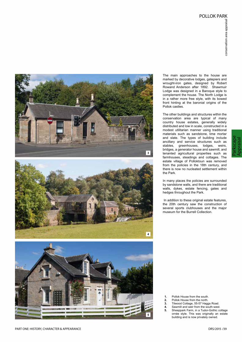
POLLOK PARK
cons
erva
tion
area
app
rais
al
DRS/2015 /39
Park
scap
e A
ppra
isal
3
1. Pollok House from the south.2. Pollok House from the north.3. Titwood Cottage, 55-57 Haggs Road.4. Sawmill and weir from the south-west.5. Sheeppark Farm, in a Tudor-Gothic cottage
ornée style. This was originally an estate building and is now privately owned.
4
5
PART ONE: HISTORY, CHARACTER & APPEARANCE
The main approaches to the house are marked by decorative lodges, gatepiers and wrought-iron gates, designed by Robert Rowand Anderson after 1892. Shawmuir Lodge was designed in a Baroque style to complement the house. The North Lodge is in a rather more free style, with its bowed front hinting at the baronial origins of the Pollok castles.
The other buildings and structures within the conservation area are typical of many country house estates, generally widely distributed and low in scale, constructed in a modest utilitarian manner using traditional materials such as sandstone, lime mortar and slate. The types of building include ancillary and service structures such as stables, greenhouses, lodges, weirs, bridges, a generator house and sawmill, and tenanted agricultural properties such as farmhouses, steadings and cottages. The estate village of Polloktoun was removed from the policies in the 18th century, and there is now no nucleated settlement within the Park.
In many places the policies are surrounded by sandstone walls, and there are traditional walls, dykes, estate fencing, gates and hedges throughout the Park.
In addition to these original estate features, the 20th century saw the construction of several sports clubhouses and the major museum for the Burrell Collection.

POLLOK PARK
conservation area appraisal
40/DRS/2015
Parkscape A
ppraisal
Landscape Character
Pollok Park can be broadly compartmentalised into 4 distinct landscape character types:
• Parkland
• Tree Cover
• Ornamental gardens
• Other
Within in each character type there are sub character types hereafter referred to as character areas that are largely reflective of function.
Parkland
• Sport; pitches (rugby football, association football, cricket) and golf courses. In terms of their role as setting for Pollok House, the Pollok Golf Course parklands to the south of the mansion are the most sensitive. These are carefully managed by the Club.
• Grazing; pasture for Highland Cattle. The parklands used for grazing form part of the broader setting of the approaches to the house and the corridor of the White Cart Water.
• Informal recreation; children’s play, setting for the Burrell Collection, Corkerhill Community Park. These areas are located more remotely from the historic setting of Pollok House.
• Other amenity open space that is not in productive use, e.g. fields west of Cowglen Golf Course.
Tree Cover
• Recreational woodland; comprising mixed species blocks of trees of various dates, and ornamental shrubs dating from the end of the 19th to the mid 20th century cut by paved and unpaved rides/paths. There are five areas of ‘Ancient Woodland’ (defined as land that is currently wooded and has been continually wooded, at least since 1750) within the conservation area, including
1
2
3
PART ONE: HISTORY, CHARACTER & APPEARANCE
Landscape Character
Pollok Park can be broadly compartmentalised into 4 distinct landscape character types:
• Parkland• Tree Cover• Ornamental gardens• Other
Within each character type there are sub character types hereafter referred to as function.

POLLOK PARK
cons
erva
tion
area
app
raisa
l
DRS/2015/41
Park
scap
e A
ppra
isal
North Wood and the Woodland Garden (see also Ornamental Gardens below).
• Roundels, shelterbelts and parkland scatter (individual trees); features typical of the parkland landscape style, comprising mixed species blocks of trees crowning the low hills/hillocks and dividing the parkland areas into distinct compartments whilst (historically) providing shelter for grazing animals.
• Avenues: that indicate routes that are important; historically, that frame views; and that form a tidy edge to the woodland rides.
• Specimen trees; individual trees planted for silvicultural interest, memorials or at key points on a walk.
1. Parkland at Pollok Golf Course, showing an example of a shelter/perimeter belt in the background and ‘parkland scatter’ in the foreground - individual trees planted to allow them to reach their full form without competition from other trees, and to break up the visual monotony of grassland. Now closely interwoven with the historic parkland layout is the golf course design, including fairways and sand bunkers.
2. Pasture for the Highland Cattle at Deer Park, north of Pollok Avenue.
3. Informal recreational area at Corkerhill Community Park. A shelter belt protects the ridge line and old hawthorn hedges still divide the former agricultural fields.
4. Recreational woodland at North Wood, the ancient woodland north of the Burrell Collection. The woods are used for walking, dog-walking, bike trails and educational purposes.
5. A parkland clump of trees on the hilllock on the south side of the White Cart Water, opposite the Stable Court. The former estate village, Polloktoun, was located near this spot.
6. An example of parkland scatter south of the White Cart Water in front of the house.
7. Pollok Avenue, marking the principal approach to Pollok House.
4
7
5
6
PART ONE: HISTORY, CHARACTER & APPEARANCE

POLLOK PARK
conservation area appraisal
42/DRS/2015
Parkscape A
ppraisal
Ornamental Gardens
• South Terraces: a series of terraces leading from Pollok House down to the White Cart Water. The two parterre gardens were laid out formally by Sir John Stirling Maxwell, but are now grassed. Stone steps, wrought-iron balustrades, sculpted vases and lions, and two ogee-roofed pavilions form the framework for the garden layout.
• Library Garden: a small formal garden planted with box hedges and seasonal flowering plants. Has the character of an intimate or ‘private’ garden in contrast with the more showy terraces to the south.
• Terraced Gardens: comprising the Walled Garden, herbaceous garden and bowling green to the east of Pollok House. The walled garden is set out in compartments and planted partly as a demonstration produce garden and partly laid to lawn with specimen trees. The herbaceous garden is currently
2
31
PART ONE: HISTORY, CHARACTER & APPEARANCE

POLLOK PARK
cons
erva
tion
area
app
raisa
l
DRS/2015/43
Park
scap
e A
ppra
isal
1. The South Terrace, looking east to west.2. The herbaceous garden looking west
towards Pollok House.3. The Library Garden, looking north towards
the Woodland Garden.4. The demonstration garden in the Walled
Garden.5. An ancient beech tree in the Woodland
Garden.6. The drive to the Stable Court showing the
retaining wall and hedge to the lowest level of the Terraced Gardens on the left.
7. The Walled garden with the Woodland Garden beyond.
8. The vase in the Woodland Garden.
4
8
5
6
7
PART ONE: HISTORY, CHARACTER & APPEARANCE

POLLOK PARK
conservation area appraisal
44/DRS/2015
Parkscape A
ppraisal
1
organised around geometric paths and planted in a modern style of ornamental grasses and herbaceous perennials.
• Woodland Garden: set on a drumlin and organised around the Pollok Beech that tops the Pollok Castle mount. The woodland garden supports a fine collection of Rhododendron and there are potentially fine views to be had across the designed landscape.
Other
Overlying the landscape character types are the circulation system and car parks for visitors to Pollok House, the Country Park, Burrell Collection, users of the sports facilities and allotments and access for maintenance and management.
Hydrology
The White Cart Water forms a key functional and aesthetic feature in the Pollok Park landscape. It flows from Eaglesham Moor to beyond Paisley, where it meets the Black Cart Water to form the River Cart, and from there joins the River Clyde. Historically the shallow fording point here attracted settlement, and the proximity of the river determined the siting of the various castles/
mansions. The White Cart Water varies in width and depth as it takes its distinctive meandering course through the estate. In front of the current mansion it is about 15m wide and normally less than a metre deep. At this location it flows placidly, often acting as a reflecting pool for the house. The Pollok Park landscape is drained by a network of burns that flow into the White Cart Water. The river has also acted as a power source for the estate sawmill and hydroelectricity turbine.
Throughout its history the corridor of the White Cart Water has been notoriously susceptible to flash flooding, with the river capable of rising by up to 6m in a matter of hours. A major flood prevention scheme was implemented between 2006 and 2011, creating flood storage areas upstream and raising embankments in urban areas. However, ‘hard engineering’ of the length of the banks at Pollok Park is inappropriate on a number of grounds, and substantial areas of low-lying lands remain vulnerable to flooding. Damage is most severe in respect of the built heritage at the Stable Court, Sawmill and Walled Garden, where some discreet engineering may be possible.
2
Building Materials
Many of the buildings on the estate, including the Laighe Castle, Stable Court, Pollok House and its later wings were built from local sandstone known as Barrhead Grit. This stone has an unusually high quartz content, which makes it quite distinctive. It was quarried in several locations on the estate. Small quarries on the Cowglen Golf Course were re-opened to supply stonework for Rowand Anderson’s additions to the house and the new lodges in the 1890s. Closely matching finer sandstone appears to have been used for the sculptural elements. Limestone from the Maxwell lands of Darnley was probably the source of the lime mortars used to bond the stonework.
Roofs are generally slated using materials from the West or Central Highlands – dark grey slates from Easdale or Ballachulish, grey, green or red slates from Luss. Chimney cans are generally of clay or terracotta.
PART ONE: HISTORY, CHARACTER & APPEARANCE

POLLOK PARK
cons
erva
tion
area
app
raisa
l
DRS/2015/45
Park
scap
e A
ppra
isal
1. The White Cart Water west of Pollok House, before it passes under the M77.
2. Detail of a carved panel on the east garden pavilion.
3. Shawmuir Lodge, boarded up and showing signs of lack of maintenance of the roof, rainwater goods and stonework.
3
Condition
Buildings
At the time of writing a number of listed buildings within the conservation area are in poor condition, including Pollok House itself and the garden terraces, the south and west ranges of the Stable Court, the Sawmill, Shawmuir Lodge, the Burrell Collection and Kennishead Farm. All these buildings, except Pollok House and the Burrell Collection, are currently included on the Buildings at Risk Register. Kennishead Farm, listed at Category C, is roofless and in an advanced state of decay. Underlying problems associated with flooding need to be addressed before repairs can be taken forward at the Stable Court and Sawmill.
Broompark Farm on Barrhead Road is not listed, but it is also roofless and included on the Buildings at Risk Register.
Open space
Time, cost, the fragmentation of ownership and change of use with associated variation in maintenance and management regimes has resulted in the gradual erosion of the historic parkland character, the loss of trees particularly within the Deer Park
and across Pollok Golf Course, where there has been incremental clearance and replanting with limited reference to the historical planting pattern. Pollok Golf Course was laid out by Dr Alister MacKenzie, one of the world’s leading course designers in 1920. There is a balance to be made between the value attached to the setting of Pollok House and the interest of the golf course layout, which is now approaching a century old.
Parkland excluding: pitches (rugby football, association football, cricket) and allotments
• Golf Courses: characterised as parkland golf courses and managed accordingly with tees, fairways, greens and rough set within trees, roundels and woodland. The parkland scatter and pattern of roundels illustrated on the 19th century Ordnance Survey maps has been eroded through the natural loss of trees and some historic clearance to accommodate the golf course layouts.
• Grazing; pasture for Highland Cattle. Primarily within the old Deer Park many of the trees are over-mature. The ha-has (sunken fences) on
either side of the main avenue are ill-defined. Parkland style of fencing is badly proportioned, heavy and has a municipal character.
• Parkland; informal recreation, children’s play, and setting for the Burrell Collection. Generally managed as amenity grassland, hard wearing and appropriate for heavy public use.
• Other open space: Corkerhill Community Park is a sloping area of parkland that rises up to the M77 from the White Cart Water through which visitors move towards the core of Pollok Park. It is maintained as amenity grassland right up to the large roundel that crowns Corker Hill and woodland block beside Corkerhill Road and as such is subject to intensive mowing regime. There has been some replanting on a straight line. Some patches of invasive perennials (Himalayan balsam, Japanese knotweed and giant hogweed beside the White Cart Water.
Tree Cover:
Tree cover is one of the most important factors in defining the character of any designed landscape as the trees create the spaces that become the setting for buildings and for activities. Trees define boundaries, shape and ornament the parklands, give prominence to roads and views and decorate gardens. General observations are:
PART ONE: HISTORY, CHARACTER & APPEARANCE

POLLOK PARK
conservation area appraisal
46/ DRS/2015
Parkscape A
ppraisal
• Pollok Park is extensively wooded and the planting on the drumlins is an important feature within the wider landscape/cityscape.
• The uniform age structure of the woodlands, shelterbelts, boundary plantings and parkland scatter is a cause for concern because the tree population will fall into decline uniformly across the designed landscape. The longer living species (ash Fraxinus excelsior, oak Quercus robur and sycamore Acer pseudoplatanus) assuming they do not succumb to disease will continue to provide structure, but without active management there is a risk that the woodlands will become increasingly dominated by sycamore and beech.
• Despite the fragmented ownership the designed landscape continues to read as a whole, primarily because there is a consistency in the woodland character across the site. The uniform age structure and the key landscape tree, beech (Fagus sylvatica), are important elements of that character, but long-term succession planning is required.
• The boundary planting remains intact but along parts of the Dumbreck Road (B768) is in variable condition and has
become too thin to effectively screen road vehicles.
• The étoile feature at Pollokhead Wood is long gone, as has much of the parkland scatter to the south of the White Cart Water.
The condition of the woodland and individual trees are beyond the competence of this study. Some general points are that Glasgow City Council undertake inspections of trees around the buildings and adjacent to public areas for reasons of health and safety. Dead, dying and diseased trees are removed for safety reasons and for the general health of the tree population.
All woodland and tree cover was assessed by Donald Rodger Arboricultural Consultants (DRAC) in 2002. This report is
of date.
Ornamental Gardens:
• South Terraces: Established across the earlier stables road and a much earlier set a series of terraces leading from Pollok House down to the White Cart Water. The upper terrace survives as a planted parterre. At the time of writing sections of the terrace wall and the central steps had been partially fenced off. The large mid
terrace, is predominantly lawn with
sempervirens). The lowest terrace leads to the edge of the White Cart Water and is crossed by the road that leads to the stables courtyard and saw mill. The unchecked spread of the male fern (Dryopteris felix-mas) has the potential to damage stone work as the hard knuckle-like plant that has seeded into the joints of the walls and paths enlarges annually. Generally the stone; walls and paving requires repair and the ornamental iron work requires urgent conservation repair.
• Woodland Garden: set on a drumlin and organised around the Pollok Beech that tops the Pollok Castle mount. The woodland garden supports
the OS plans and species composition (holly and yew) suggest that the mound would have been planted and
tsap eht ni ylevitca erom deniatniamthan is currently the case. Judging from the large number of holly and yew it is likely that these were managed as
of the crown of the mound/drumlin and give a neat edge to the wood. The hedge has been allowed to grow into an evergreen screen and potentially
landscape are obscured.
PART ONE: HISTORY, CHARACTER & APPEARANCE
1

POLLOK PARK
cons
erva
tion
area
app
raisa
l
DRS/2015/47
Cha
ract
erA
sses
smen
t
1. Long view across the Park from the path to Sheeppark Farm, showing the importance of tree cover to the character of the landscape.
2. Craigholme School Sports Complex. A high-quality new building on the edge of the Pollok Park landscape at Haggs Road. designed by SMC Davis Duncan Architects and completed in 2006.
CHARACTER ASSESSMENT
number of local environmental designations including: city-wide Sites of Importance for Nature Conservation (SINC), Sites of Special Landscape Importance (SSLI) and Corridors of Wildlife and/or Landscape Importance. Policy ENV 1 of City Plan 2 also sets out a strong presumption in favour of the retention of all public and private green/open space and affords protection to open space shown on the Council’s ‘Glasgow Open Space Map’.
Open spaces in poor condition also have the potential to be repaired so as to contribute positively to the character of the area.
Introduction
Having examined the historical development and landscape of the Conservation Area, it is now possible to carry out an assessment of the area’s character and identify those features that contribute to its character and appearance as an area of special architectural and historic interest. The following sections identify:
• the principal buildings and spaces that contribute to the interest of the Conservation Area;
• the key features of the Conservation Area.
Assessment of Buildings & Spaces
An important part of character assessment involves the evaluation of buildings and spaces, identifying those that make a valuable contribution to the character and appearance of the Conservation Area. In general, the most significant architectural or historic buildings and spaces are recognised by official designations, as shown in the maps on the following page. Other undesignated buildings and spaces also can play a significant role in creating the identity and interest of the Conservation Area.
Listed Buildings
Buildings that are ‘listed’ have already been assessed by Historic Scotland as being of special architectural or historic interest and are included on the Scottish Ministers’ statutory list.
There are 12 listed building either within or on the boundary of the Conservation Area. These are identified on the map at Figure 1 on the following page. Four of the listed buildings are listed at Category A, the highest level of architectural or historic interest. Listed buildings contribute positively to the appearance of the Conservation Area, provide points of interest and enrich the area’s special character. Listed buildings
in poor condition have the potential to be repaired and contribute positively to the character of the area.
Unlisted Buildings that Contribute Positively to the Character/Appearance of the Conservation Area
These are buildings identified for the purpose of this appraisal, which although unlisted, make a positive, visual or historical contribution to the character and appearance of the Conservation Area. They may be modest traditional buildings that are characteristic of the estate architecture, more modern buildings associated with the sporting uses, or recent buildings that do not meet the criteria for listing.
Designated Open Spaces (National Non-Statutory and City Plan Designations)
Almost all of the Conservation Area is included in Historic Scotland’s national Inventory of Gardens and Designed Landscapes. Only a small area surrounding Kennishead Farm is not part of the Inventory site.
The adopted Glasgow City Plan 2 identifies a
2
PART ONE: HISTORY, CHARACTER & APPEARANCE

POLLOK PARK
conservation area appraisal
48/DRS/2015
Character
Assessm
ent
1. HERITAGE DESIGNATIONS
Pollok Houseincluding service court, forecourt, garden walls, pavilions
Burrell Collection
North Lodge
South LodgeRailway Underbridge
Pollokshaws West Station
Viaduct over White Cart Water
Shawmuir LodgeWalled Gardens & Dry Bridge
Stable CourtSawmill, Power Station & Caul
White Cart Bridge
Kennishead Farm
KEY
Conservation Area boundary
Designated Designed Landscape
Ancient Woodland
Listed Category A
Listed Category B
Listed Category C
Country Park boundary
Contains Ordnance Survey data © Crown copyright and database right, 2015
PART ONE: HISTORY, CHARACTER & APPEARANCE

POLLOK PARK
cons
erva
tion
area
app
raisa
l
DRS/2015/49
Cha
ract
erA
sses
smen
t
2. OPEN SPACES DESIGNATIONS
KEY
Conservation Area boundary
Sites of Importance for Nature Conservation
Green Corridor
Sites of Special Landscape Importance
Contains Ordnance Survey data © Crown copyright and database right, 2015
PART ONE: HISTORY, CHARACTER & APPEARANCE

POLLOK PARK
conservation area appraisal
50/DRS/2015
Character
Assessm
ent
1
1� UNLISTED BUILDINGS OF LOCAL HERITAGE INTEREST
Contains Ordnance Survey data © Crown copyright and database right, 2015
PART ONE: HISTORY, CHARACTER & APPEARANCE

POLLOK PARK
cons
erva
tion
area
app
rais
al
DRS/2015 /51
Key
Feat
ures
1. Map of unlisted buildings of local heritage interest.
2. Pollok House, the key building at the centre of the Pollok Park Conservation Area.
KEY FEATURES
2
Having carried out a detailed assessment of buildings and landscape, it is now possible to identify:
• special architectural and historic character of the area; and
• The Key Challenges, inappropriate elements that detract from the character and appearance of the area.
Key Features
The key features of the Conservation Area are its outsanding architectural elements in combination with their extensive green setting. Pollok Park is a remarkable survival of a country house estate within the bounds of a great industrial city. There are many layers of high-quality alterations and adaptations to both the building stock and the landscape, notably from the late Victorian and Edwardian periods.
Architectural quality
The focus of the Pollok Park Conservation Area is the classical country house of 1747-52, around which a number of ancillary buildings, the network of drives and the landscape are laid out. Apart from the house itself, the contemporary bridge over the White Cart Water and the Stable Court
of high-quality design was added to the house and its immediate setting in the late 19th century and early 20th century by the alterations commissioned from the architect Robert Rowand Anderson by Sir John Stirling Maxwell.
In addition to the house, bridge and stable court, Pollok Park gained another building of outstanding architectural interest in 1983 with the construction of the Burrell Collection. Although a large building, the architects sited the structure carefully to maintain the existing qualities of Pollok House and its setting, and to create a sympathetic relationship with the surrounding mature landscape.
Throughout the rest of the Conservation Area a number of typical country estate buildings survive, including lodges, farm buildings and cottages. The new sporting uses of the late 19th and 20th centuries, which are important to the continuing survival of the estate, have also left their mark in the form of clubhouses, pavilions and the Craigholme School Sports Centre. With the exception of Pollok House, the Burrell Collection and a small number of 1970s structures, the buildings are generally small in scale, low in height, and are constructed of high-quality traditional materials such as stone, slate and occasionally brick.
Landscape quality
Pollok Park is characterised as an extensive parkland landscape that is the product of many centuries of design, cultivation, adaptation and renewal on a gently rolling topography of drumlins and river plain. It
past 100 years as a result of severance, fragmented ownership, change of use and changes in maintenance and management practice.
Despite the changes that have occurred Pollok Park remains, recognisably, a designed landscape on a large scale. It
comprises the traditional components of a country estate including parkland, woodland, agricultural land, ornamental gardens and water features. There is a very low density of buildings in relation to the size of the area. The mature trees in woodland, plantations, clumps and parkland scatter
the landscape, framing views and protecting the boundaries.
Views
in all directions, largely unspoilt by the intrusion of surrounding development. In spite of more recent sporting uses and the infrastructure for major visitor attractions, the landscape is still predominantly rural in character, maintaining to a large extent the old boundary treatments (trees, hedges, estate fences, dykes and walls) and a balance of wooded areas and open parkland, Urban characteristics, such as street lighting and pavements, are mainly absent from the Park. The tranquil setting of Pollok Park is valued by local people, citizens of Glasgow and the visiting public from around the world.

POLLOK PARK
conservation area appraisal
52/ DRS/2015
Key Challenges
KEY CHALLENGES
Key Challenges
As a dynamic living landscape, with many uses and stakeholders, Pollok Park Conservation Area is constantly changing. While many changes, such as repair and reuse of historic buildings or sensitive
impact, others have the potential to damage the character and appearance of the area. The paragraphs below outline the
architectural and historic interest of Pollok Park Conservation Area.
Poor condition of buildings
As noted in the Parkscape Appraisal section above, a number of buildings in the Conservation Area are in a poor state of repair, including the major buildings, Pollok House and the Burrell Collection. Measures are in hand to make the necessary repairs to a number of buildings, but a key challenge is to deal with the structures adjacent to the White Cart Water, which are damaged by
from the core of the Conservation Area the former farm steadings at Broompark and Kennishead are in a state of advanced dereliction.
Maintenance of historic planting character
The extent and variety of tree cover is one of the most important characteristics of the Pollok Park designed landscape. In the past there have been periods of active tree-planting, but the during the last sixty years or so tree-planting has been carried out on a relatively modest scale, particularly within the Country Park. The result is that
is now mature or over-mature, with little younger stock to take its place. There is a potential for areas of uniform age to die out naturally, or be lost through storm damage, leaving large gaps in the tree cover. Some of the tree belts around the boundaries of the Park have become quite thin, allowing more intervisibility with the surrounding urban areas.
New threats, such as disease and climate change, may also impact upon the health, vigour and character of the present tree stock and lead to pressure to plant different species.
Use of inappropriate materials
The use of materials in any Conservation Area is another important element of its character and appearance. The use of traditional materials provides a cohesive effect across the Conservation Area. Where these are replaced with modern materials and/or detailing there will normally be a loss of character. Inappropriate materials and detailing often stand out from traditional materials by virtue of their uniformity
comparatively poor long-term weathering appearance. Common examples include: the replacement of original timber windows with modern plastic substitutes that lack the subtle detailing and variety of character of 19th-century timber sash and case
the replacement of cast-iron rainwater goods with plastic or zinc; the use of zinc or other metal panels on elevations; cladding using thin stone panels.
Co-ordinated management
Although the lands included within the Conservation Area still read as a single designed landscape, there are multiple owners and tenants involved in the management of the whole area.
There are increasing pressures for commercial activities within the Park, both from outside operators and from a need to generate income for maintenance and operation of the Park. In some cases there
1
PART TWO: PRESERVATION & ENHANCEMENT
At the time of the gift of the Estate to the City Council the ‘Pollok Advisory Committee’ (PAC) was established to advise and steer the responsible landowners and their tenants in terms of the 1939 Agreement. This met regularly during the planning and implemen-tation of the construction of the M77 and more recently when a proposal for ‘Go-Ape’ to be located within the park was brought forward. Pollok Corrour represent the family on this Committee, and the understanding is that this mechanism is used to obtain author-isation for works to properties. A separate Pollok House Joint Committee also exists.

POLLOK PARK
cons
erva
tion
area
app
rais
al
DRS/2015 /53
Key
Chal
leng
es
.kraP eht fo noitatiolpxe laicremmoc dna
Clear guidance on the extent of commercial
activity permissible or desirable under the 1939 Agreement with the National Trust fo
r
LUC (Land Use Consultants) drew up the Pollok Estate Management Plan in 2002
,
but it has not been adopted or revised since that date. The Management Plan contained a Woodland Management Plan as a separate element.
Boundary Treatments
A number of traditional boundary fences, walls, hedges and trees, which are distinctive features of the landscape within and around the boundary of the Park, are in poor condition or have been replaced with inappropriate substitutes.
and Parking
The vehicular entrances and exits to the Country Park in particular are poorly designed and marked. There is little sense of arrival from Haggs Road, and once inside the Park the gateway at Shawmuir Lodge is
too narrow for large vehicles to pass without the potential for damage. The entrances, exits and circulation system are especially restrictive when there are large events in the Park.
Within the Country Park there is no clear
cyclists and vehicles, particularly on Pollok Avenue between Pollok House and the
be disruptive to pedestrians and cyclists’
enjoyment of the Park.
Although there is a designated car park for visitors to the house, many visitors park in the forecourt. The use of the forecourt as an informal car park detracts from the quality of this impressive entrance front of the house. Similarly, informal parking on the east side of the North Lodge gateway detracts from this beautiful entrance to the estate.
The visual impact of the large car park at the Burrell Collection is reduced by it being
Flooding and drainage
concern along the corridor of the White Cart Water. Poor drainage is also an issue in
Collection, some of the woodland paths and
park.
The reduction of CO2 emissions and
traditional buildings without damage to their
Tall buildings
Tall buildings have the potential to introduce an incongruous element on the skyline around the Park. For the future development of tall buildings it is necessary to identify sites and designs that protect the interest of the Conservation Area.
Financial constraints
It is recognised that global economic situation
public and private sector will impact on the resources available for preservation and enhancement of the historic environment.
of funding and other resources to maximise
key recommendation of this appraisal (see Management Planning below).
1. The south range of the Stable Court, propped for structural support. Flooding problems in this location have undermined the stability of the Category A listed building.
2. Poorly proportioned double glazing units detract from the traditional design qualities of this estate lodge.
PART TWO: PRESERVATION & ENHANCEMENT
IThis Conservation Area Appraisal sets out the issues of significance and the parame
-
ters for the preservation and enhancement of this significant asset. It recommends the preparation of the Conservation Area Management Plan (CAMP), which is the next stage in the process. The main purpose of the CAMP will be to ensure that co-ordinated and prioritised management of the Conser
-
vation Area is agreed and taken forward by the multiple stakeholders within the area. Both the Appraisal and CAMP document(s) will be important elements in making the case for funding to e.g. Heritage Lottery Fund. The CAMP will be the overarching document within which the conservation plans for various elements of Pollok Park sit. These are likely to include:
• Burrell Collection• Pollok House• The Stable Courtyard and sawmill• The woodland and designed landscape (included in the Inventory of Gardens and Designed Landscapes in 1987)• The Country Park Management (which is a smaller area than the Pollok Park Conservation Area)
Access, Entrances, Circulation, Traffic
2
partly dug into the slope of the land, but the road also carries high levels of through to exit the car park and for pedestrians to cross to the museum.
Within the woodlands, there is a mixture of surfaced and unsurfaced paths. Navigation around the woodlands is not always clear. Some of the unsurfaced paths, such as the All of the above must be considered against the context of the Council’s Access Strategy and the Core Paths Scheme’.
is a fine line between the public benefit and commercial exploitation of the Park. Clear guidance on the extent of commercial activity permissible or desirable under the 1939 Agreement with the National Trust for Scotland would be of benefit.
LUC (Land Use Consultants) drew up the Pollok Estate Management Plan in 2002 but it has not been adopted or revised since that date. The Management Plan contained a Woodland Management Plan as a separate element.
This Conservation Area Appraisal sets out the issues of significance and the parameters for the preservation and enhancement of this significant asset. It recommends the preparation of a Conservation Area Management Plan (CAMP), which is the next stage in the process. The main purpose of the CAMP will be to ensure that co-ordinated and prioritised management of the Conservation Area is agreed and taken forward by the multiple stakeholders within the area. Both the Appraisal and CAMP document(s) will be important elements in making the case for funding to e.g. Heritage Lottery Fund. The CAMP will be the overarching document within which the conservation plans for various elements of Pollok Park sit.
These are likely to include:
• Burrell Collection• Pollok House• The Stable Courtyard and sawmill• The woodland and designed landscape (included in the Inventory of Gardens and Designed Landscapes in 1987)• The Country Park Management Plan ( w h i c h is a smaller area than the Pollok Park Conservation Area )
Boundary Treatments
A number of traditional boundary fences, walls, hedges and trees, which are distinctive features of the landscape within and around the boundary of the Park, are in poor condition or have been replaced with inappropriate substitutes.
Access, Entrances, Circulation, Trafficand Parking
The vehicular entrances and exits to the Country Park in particular are poorly designed and marked. There is little sense of arrival from Haggs Road, and once inside the Park the gateway at Shawmuir Lodge is too narrow for large vehicles to pass without the potential for damage. The entrances, exits and circulation system are especially restrictive when there are large events in the Park.
Within the Country Park there is no cleardefinition of priorities for pedestrians, cyclists and vehicles, particularly on Pollok Avenue between Pollok House and the burrell Collection. The through traffic can be disruptive to pedestrians and cyclists’ enjoyment of the Park.
Although there is a designated car park for visitors to the house, many visitors park inthe forecourt. The use of the forecourt as an informal car park detracts from the quality of this impressive entrance front of the house. Similarly, informal parking on the east side of the North Lodge gateway detracts from this beautiful entrance to the estate.
The visual impact of the large car park at the Burrell Collection is reduced by it beingpartly dug into the slope of the land, but theroad also carries high levels of through traffic to exit the car park and for pedestrians to cross to the museum.
Within the woodlands, there is a mixture ofsurfaced and unsurfaced paths. Navigation around the woodlands is not always clear. Some of the unsurfaced paths, such as therhododendron walk, have become difficult to find, and very muddy to follow in places.All of the above must be considered against the context of the Council’s Access Strategy and the Core Paths Scheme’.
Flooding and drainage
As noted above, flooding is a major concern along the corridor of the White Cart Water. Poor drainage is also an issue in places, notably the field beside the Burrell Collection, some of the woodland paths and the field adjacent to the Pollok House car park.
The reduction of CO2 emissions and improvement in energy efficiency of traditional buildings without damage to their character is a significant challenge.
Tall buildings
Tall buildings have the potential to introduce an incongruous element on the skyline around the Park. For the future development of tall buildings it is necessary to identify sites and designs that protect the interest of the Conservation Area.
Financial constraints
It is recognised that global economic situation and financial constraints across both the public and private sector will impact on the resources available for preservation and enhancement of the historic environment. The planning of priorites and identification of funding and other resources to maximise the benefits of the conservation Area is a key recommendation of this appraisal (seeManagement Planning below).
1. The south range of the Stable Court, propped for structural support. Flooding problems in this location have undermined the stability of the Category A listed building.
2. Poorlyproportioned double glazing units detract from the traditional design qualities of this estate lodge.
2

POLLOK PARK
conservation area appraisal
54/DRS/2015
Character
Assessm
ent
PART ONE: HISTORY, CHARACTER & APPEARANCE

POLLOK PARK
cons
erva
tion
area
app
raisa
l
DRS/2015/55
Con
serv
atio
n A
rea
Boun
dary
1. Map of showing the existing Conservation Area boundary and the proposed amendments.
3
PART TWO: CONSERVATION AREA PRESERVATION & ENHANCEMENTCONSERVATION AREA BOUNDARIES
Boundary History
Pollok Park Conservation Area was originally designated in 1995. The boundaries have remained unchanged since that date.
Boundary Amendments
A detailed examination of the existing Pollok Park Conservation Area boundary has resulted in three recommended adjustments.
Two of the proposed amendments (Nos. 1 and 3) take account of the construction of the M77 Motorway through the northern and western edge of the Pollok Estate between 1995 and 1996. Proposed amendment No. 2 recommends the incorporation of a further area of land to the north of St Paul’s High School.
1) Exclusion of the M77 between Junction 1 at the Dumbreck Interchange to Corkerhill.
2) Inclusion of both banks of the White Cart Water from the M77 to Corkerhill Road and also the land to the north of St Paul’s High School and west of the M77.
3) Minor adjustment of the boundary south of Junction 2 of the M77 at Kennishead to follow the eastern edge of the carriageway.
Further details of the boundary amendments are set out on the following pages.
•
BOUNDARIES KEY
Existing Conservation Area
Proposed Conservation Area
•Pollok House
Burrell Collection
Proposed Boundary Amendment 1
Prop
osed
Bou
ndar
y Am
endm
ent 2
Proposed Boundary Amendment 3 Contains Ordnance Survey data © Crown
copyright and database right, 2015
PART TWO: PRESERVATION & ENHANCEMENT

POLLOK PARK
conservation area appraisal
56/DRS/2015
Conservation
Area Boundary
1
Boundary Amendment 1: Exclusion of M77 carriageway between Junction 1 and Corkerhill
The amendment excludes a stretch of the M77, which was constructed in controversial circumstances after the initial designation of the conservation area in 1995. The current conservation area boundary follows the north side of the motorway and a thin strip of planting (on the right hand side of Photograph 2). This boundary amendment proposal excludes the carriageways of the M77, but maintains the inclusion of the embankments and planting on the south side, which form a screen between the motorway and Haggs Castle Golf Course (left hand side of photograph 2). The carriageways are not sympathetic to the rural characteristics of the conservation area. Where there are no significant areas of designed landscape on the north side of the motorway, and the existing north embankment planting is not visible from within the core of the park, there is little practical purpose in maintaining the carriageway within the conservation area.
2
M77
M77
Existing Conservation Area
Proposed Conservation Area
Haggs Castle Golf Course
Contains Ordnance Survey data © Crown copyright and database right, 2015
PART TWO: PRESERVATION & ENHANCEMENT

POLLOK PARK
cons
erva
tion
area
app
raisa
l
DRS/2015/57
Con
serv
atio
n A
rea
Boun
dary
1. Map showing Boundary Amendment 1.2. View of the M77 from Dumbreck Interchange
looking west. The carriageway is currently included within the conservation area.
3. Map of Boundary Amendment 2.4. Photograph of Boundary Amendment 2,
looking east from the centre of Damshot Crescent.
5. Map showing Boundary Amendment 3.
trees themselves) of the southern half of the large heart-shaped plantation is marked on the 1892 Ordnance Survey map. Similarly the stretch of the White Cart Water between the M77 and Corkerhill Road continues the character of the river in the conservation area on the east side of the motorway.
Boundary Amendment 3: Minor adjustment of the boundary south of Junction 2 of the M77 at Kennishead to follow the eastern edge of the carriageway
The current boundaries at this location were drawn up before the motorway construction began. Minor adjustments to exclude a sliver of roadway and include a sliver of farmland are proposed to reflect the eastern edge of the M77 carriageway as built.
Boundary Amendment 2: Inclusion of both banks of the White Cart Water from the M77 to Corkerhill Road and also the land to the north of St Paul’s High School and west of the M77
At present, the conservation area boundary at Corkerhill runs along the River White Cart (on the north bank in some places and along the middle of the river in others) and down the west side of the M77 carriageway (i.e the motorway carriageway is currently included in the conservation area). The boundary amendment proposal is intended to include within the conservation area both banks of the White Cart Water and the area of grassland and woodland plantations to the north of St Paul’s High School and west of the M77. Under the City’s greenspace audit, the land is classed as ‘amenity greenspace’ and ‘green corridor’ along the riverbanks and motorway edges. The grassland and woodland plantations, formerly part of the old estate farm of Damshot, are currently included within the Pollok Park Designated Designed Landscape.
The area of grassland and woodland plantations is of similar character to many parts of the existing Pollok Park conservation area. The structure (if not the
3 4St Paul’s High School
White Cart Water
Dam
shot
Cre
scen
t
M77
Existing
Proposed
Existing
Proposed
Pollok Park Conservation Area
Pollo
k Pa
rk C
onse
rvat
ion
Area
5
Contains Ordnance Survey data © Crown copyright and database right, 2015
PART TWO: PRESERVATION & ENHANCEMENT

POLLOK PARK
conservation area appraisal
58/ DRS/2015
Preservation/Enhancem
ent
Introduction
Detailed analysis of the area’s character and the challenges facing it has highlighted opportunities for its preservation and enhancement.
Pollok Park Conservation Area is large, with a wide variety of people and agencies, including the City Council, sharing responsibility for its care and maintenance. The City Council has a statutory duty to protect and enhance the historic environment and will, within the resources available, strive to ensure that all initiatives and projects in the area take cognisance of the opportunities to provide preservation
Management Planning
the prioritisation and coordination of preservation and enhancement actions and resources throughout the whole area. A thorough Pollok Park Estate Management Plan was drawn up in 2002, which covered conservation issues in some depth, but this was never formally adopted by the commissioning parties. Although the document is now out-of-date in a number of respects, it provides a sound basis for a new document for the present day. The CAMP should seek to maximise the effect of available esources in the Conservation Area by:
• Encouraging different parts of the Council and other organisations, groups and individuals to work together on priorities;
• Ensuring that appropriate information and advice about practical conservation and planning issues is readily available;
• Identifying potential funding and other
PRESERVATION & ENHANCEMENT
1
PART TWO: PRESERVATION & ENHANCEMENT
Although there is currently Pollok Country Park Management Plan 2011 – 16 (with updated Action Plan 2016 – 2019) and a Pollok Country Park Masterplan in prepa-ration in support of the Burrell Renais-sance Project, the Conservation Area would benefit from an overall Conservation Area Management Plan (CAMP) to assist in
resources;
Introduction
Detailed analysis of the area’s character and the challenges facing it has highlighted opportunities for its preservation and enhancement.
Pollok Park Conservation Area is large, with a wide variety of people and agencies, including the City Council, sharing responsibility for its care and maintenance. The City Council has a statutory duty toprotect and enhance the historic environment and will, within the resources available, strive to ensure that all initiativesand projects in the area take cognisance of the opportunities to provide preservation and enhancement as identified below.
Management Planning
Although there is currently Pollok Country Park Management Plan 2011 – 16 (with updated Action Plan 2016 – 2019) and a Pollok Country Park Masterplan in preparation in support of the Burrell Renaissance Project, the Conservation Area would benefit from an overall Conservation Area Management Plan (CAMP) to assist in the prioritisation and coordination of preservation and enhancement actions and resources throughout the whole area. A thorough Pollok Park Estate Management Plan was drawn up in 2002, which covered conservation issues in some depth, but this was never formally adopted by the commissioning parties. Although the document is now out-of-date in a number of respects, it provides a sound basis for a new document for the present day. The CAMP should seek to maximise the effect of available esources in the Conservation Area by:
• Encouraging different parts of the Council and other organisations, groups and individuals to work together on priorities;• Ensuring that appropriate information and advice about practical conservation
and planning issues is readily available;• Identifying potential funding and other resources.

DRS/2015 /59
Pres
erva
tion/
Enha
ncem
ent
• Prioritising projects and other actions;
• Identifying management issues and any problems with control of works in the Conservation Area and seeking to resolve them;
• Identifying means of promoting awareness of the interest and importance of the Conservation Area through education, interpretation, activities and events.
1. Rusty decorative ironwork in need of repair and painting on the terrace steps at the south front of Pollok House.
PART TWO: PRESERVATION & ENHANCEMENT
Involvement of owners, stakeholders, partner organisations and local communities in the development of the plan is essential, particularly where there are complicated, or even conflicting, interests in the site.
Some critical sites and areas, such as Pollok House, the Stable Court and the Burrell Collection, merit their own individual conservation plans to ensure that their understood, considered and protected.
Whilst it is noted that individual Golf Courses within the Park may have their own Wood-land Management Plans in place – in view of the importance of trees to the character of the Conservation Area, it is recommended that a unified Woodland Management Plan is adopted by the various owners and managers, covering the whole estate. To this end, LES is developing a Trees and Woodland Management Plan.
Opportunities for Preservation and Enhancement
OPP 1: Buildings
At the time of writing plans are in progress for the repair of several buildings in the Conservation Area. WBG Waterston Conservation Architects have recently been appointed to oversee a 10-year programme of phased repairs to Pollok House and gardens, funded by Glasgow City Council, Historic Scotland and the National Trust for Scotland. Phase 1 HLF funding has been secured for an ambitious scheme to refurbish and improve access to the Burrell Collection and associated visitor infrastruc-ture.
The Council intends to carry out remedial work to the portion of the Stables subject to structural bracing. In addition, an Options Appraisal has been prepared by Glasgow
Building Preservation Trust to inform the potential future redevelopment of the buildings.
The issue of flooding continues to be a serious problem, particularly in relation to the Stable Court complex, Sawmill and Walled Garden. Under the Pollok Park Masterplan, one option which could be considered is to install discreet, ground-recessed, mechani-cally-operated hydraulic barriers around the perimeters of the affected zones to protect park assets such as the house and stables, while allowing areas such as the pasture to flood naturally.
The Category C-listed Kennishead Farmhouse and steading and the unlisted and in advanced states of decay.
Over time it would be desirable to redevelop the less well-designed buildings within the eht edulcni esehT .dradnats hgih a ot kraP1970s Nether Pollok Football Pavilion, the two police buildings (Police Club and Dog Handling Centre), and the maintenance depot.
OPP 2: Parkland
Golf Courses: encourage the clubs to reinstate the parkland scatter and pattern of roundels illustrated on the 19th century Ordnance Survey maps wherever possible course layouts by MacKenzie and Braid) when replanting. Encourage the use of ‘landscape’ trees like beech, oak, sweet
chestnut, horse chestnut, sycamore and not small ornamental species like birch, rowan and maple.
Grazing: Establish a planting programme for Deer Park which may include some clearance of the high ground to make space for new trees (oak the most appropriate species), with robust protection from cattle. Dig out/deepen the ha-ha ditches and repair the walls. If the opportunity arises replace existing modern steel fencing with traditional 5-bar parkland fence. The stocking density of cattle should be assessed to consider botanical diversity of the grassland, with enhancement planting/seeding if required. In general the main pasture areas in the centre of the Park have been identified as having poor condition singular parkland style trees and some roundel features have dead trees – singular tree planting in these fields has been identified as possible commemorative
tree planting opportunities and something may be included in the planned LES Trees & Woodlands Management Plan.
Informal recreation areas: varying the mowing regime at woodland edges and glades (number of grass cuts and height to which grass is cut) to increase biodiversity has already been implemented in some areas. This was part of the grant funded partnership project Glasgow’s Buzzing, and focussed on the glade, ash path meadow and the woodland glade behind the gardens. A large amount of community engagement has already been carried out in these areas. There is scope to increase these areas and carry out further enhance-ment through community engagement projects with the Countryside Rangers. Reduced maintenance regimes at Corkerhill would enhance biodiversity, but planting/-seeding may also be required. Manage-ment of rank grassland near Damshot as a hay meadow would benefit biodiversity, but some uncut areas should be retained for over wintering invertebrates and small mammals. There is scope for large-scale meadow creation to be incorporated in to upgrades of the Burrell and this could provide a colourful, biodiversity rich backdrop to the building and/or any outdoor formal space associated with the building. All wildflower meadow creation/enhance-ment helps deliver the Neutral Grassland Habitat Action in the LBAP. There is also scope to help pollinating insects through the creation of non-native meadows through planting wildlife friendly nectar rich plants. A woodland edge mowing regime that allows for greater biodiversity could include some woodland edge planting (low density and sporadic groups) as the current woodland edges are not very structurally graded in Pollok Country Park and could be something that can be added as part of the Trees & Woodlands Management Plan.
• Prioritising projects and other actions;
• Identifying management issues and any problems with control of works in the Conservation Area and seeking to resolve them;
• Identifying means of promoting awareness of the interest and importance of the Conservation Area through education, interpretation, activities and events.
Involvement of owners, stakeholders, partner organisations and local communities in the development of the plan is essential, particularly where there are complicated, or even conflicting, interests in the site.
Some critical sites and areas, such as Pollok House, the Stable Court and the Burrell Collection, merit their own individual conservation plans to ensure that they are understood, considered and protected.
Whilst it is noted that individual Golf Courses within the Park may have their own Woodland Management Plans in place – in view of the importance of trees to the character of the Conservation Area, it is recommended that a unified Woodland Management Plan is adopted by the various owners and managers, covering the whole estate. To this end, LES is developing a Trees and WoodlandManagement Plan.
Opportunities for Preservation andEnhancement
OPP 1: Buildings
At the time of writing plans are in progressfor the repair of several buildings in the Conservation Area. WBG Waterston Conservation Architects have recently been appointed to oversee a 10-year programme of phased repairs to Pollok House and gardens, funded by Glasgow City Council, Historic Scotland and the National Trust for Scotland. Phase 1 HLF funding has been secured for an ambitious scheme to refurbish and improve access to the Burrell Collection and associated visitor infrastructure.
The Council intends to carry out remedialwork to the portion of the Stables subject tostructural bracing. In addition, an OptionsAppraisal has been prepared by Glasgow
Building Preservation Trust to inform the potential future redevelopment of the buildings.
The issue of flooding continues to be a serious problem, particularly in relation to the Stable Court complex, Sawmill and Walled Garden. Under the Pollok Park Masterplan, one option which could be considered is to install discreet, ground -recessed, mechanically - operated hydraulic barriers around the perimeters of the affected zones to protect park assets such as the house and stables, while allowing areas such as the pasture to flood naturally.
The Category C-listed Kennishead Farmhouse and steading and the unlisted and in advanced states of decay.
Over time it would be desirable to redevelop the less well-designed buildings within the Park to a high standard. These include the 1970s Nether Pollok Football Pavilion, the two police buildings ( Police Club and Dog Handling Centre ), and the maintenance depot.
OPP 2: Parkland
Golf Courses: encourage the clubs to reinstate the parkland scatter and pattern of roundels illustrated on the 19th century Ordnance Survey maps wherever possible course layouts by MacKenzie and Braid) when replanting. Encourage the use of ‘landscape’ trees like beech, oak, sweet chestnut, horse chestnut, sycamore and not small ornamental species like birch, rowan and maple.
Grazing: Establish a planting programme for Deer Park which may include some clearance of the high ground to make space for new trees (oak the most appropriate species), with robust protection from cattle. Dig out/deepen the ha-ha ditches and repair the walls. If the opportunity arises replace existing modern steel fencing with traditional 5-bar parkland fence. The stocking density of cattle should be assessed to consider botanical diversity of the grassland, with enhancement planting/seeding if required. In general the main pasture areas in the centre of the Park have been identified as having poor condition singular parkland style trees and some roundel features have dead trees – singular tree planting in these fields has been identified as possible commemorative tree planting opportunities
and something may be included in the planned LES Trees & Woodlands Management Plan.
Informal recreation areas: varying the mowing regime at woodland edges and glades (number of grass cuts and height to which grass is cut) to increase biodiversity has already been implemented in some areas. This was part of the grant funded partnership project Glasgow’s Buzzing, and focussed on the glade, ash path meadow and the woodland glade behind the gardens. A large amount of community engagement has already been carried out in these areas. There is scope to increase these areas and carry out further enhancement through community engagement projects with the Countryside Rangers. Reduced maintenance regimes at Corkerhill would enhance biodiversity, but planting/- seeding may also be required. Management of rank grassland near Damshot as a hay meadow wouldbenefit biodiversity, but some uncut areas should be retained for over wintering invertebrates and small mammals. There is scope for large-scale meadow creation to be incorporated in to upgrades of the Burrell and this could provide a colourful, biodiversity rich backdrop to the building and/or any outdoor formal space associated with the building. All wildflower meadow creation/enhancement helps deliver the Neutral Grassland Habitat Action in the LBAP. There is also scope to help pollinating insects through the creation of non-native meadows through planting wildlife friendly nectar rich plants. A woodland edge mowing regime that allows for greater biodiversity could include some woodland edge planting (low density and sporadic groups) as the current woodland edges are not very structurally graded in Pollok Country Park and could be something that can be added as part of the Trees & Woodlands Management Plan.
1. Rusty decorative ironwork in need of repair and painting on the terrace steps at the south front of Pollok House.

POLLOK PARK
conservation area appraisal
60/ DRS/2015
Preservation/Enhancem
ent•
• General management of woodlands, roundels and shelterbelts to improve age structure
• for the avenues and Corsican pine plantation.
• Review appropriateness of beech plantation across site of fort (earthwork 1920 OS)
• incremental clearance and replanting of island
• Reinstatement of green rides/paths .kcab gnimmirt dna gninniht hguorht
Where rides cross asphalt roads emphasise the geometry with lines (say setts)
• Develop an action plan for sudden death disorders (ash, oak, rhododendron etc)
• Continue to manage planted parterres (beside Pollok House and Library Garden) with box hedges. Consider planting up with herbaceous perennials and bulbs as an alternative to annuals to increase interest and variation in colour.
• Retain lawn across middle parterre as this is a useful gathering point for schools and other parties. Can be used as a site for temporary marquees or outdoor exhibitions. Restore to Sir John Stirling Maxwell’s planting pattern only if it can be faithfully undertaken and a long term maintenance arrangement is in place, perhaps through a 10-year sponsorship with dedicated staff and plant supply.
• Inspect clumps of male fern (Dryopteris felix-mas) to ensure they are not damaging stone work of the terraces, steps and pavilions. Remove very carefully as necessary. Ideally remove.
• Repair stonework: walls and paving and ornamental ironwork.
• Terraced Gardens: comprising the Walled Garden, Herbaceous Garden and bowling green to the east of Pollok House. Maintain as existing undertaking repairs to plans and structures as necessary
• Woodland Garden: undertake research
1
PART TWO: PRESERVATION & ENHANCEMENT
• All of the above will be considered within the Trees & Woodland Management Plan.
Implement a programme of perennial weed control. LES will seek to control invasive weed species growing on GCC land as per the INNS policy. Control of other weeds, since many of them are also native plant species, will depend on the management objectives for the specific area of vegetation in question. If land ownership issues allow, re-integrate the ‘derelict’ parkland east of Damshot Road and Damshot Crescent with Pollok Park, and explore the possibility of installing a footbridge across the White Cart Water to create a more direct link to the Park. Manage the rank grassland back to a meadow for sweet hay or as water meadows. Repair and paint boundary railing and manage double avenue of beech/oak along Damshot Crescent.
OPP 3: Tree cover
Core areas of native woodland should be identified, enhanced and increased to help deliver Glasgow’s LBAP. Ground flora should also be assessed and enhanced where required. The biodiversity value of the woodland should be assessed and included in any decision making process, including associated species (legally protected species and otherwise).
The council has surveyed all single and amenity group tree features in the park and this is covered by our management through the Ezytree system. A comprehensive tree survey should form part of the Trees & Woodlands Management Plan. The compartments and groups identified in the 2002 report by Donald Rodger Arboricultural Consultants, should be refeared to.
Subject to land ownership - review boundary planting along Dumbreck Road as a matter of priority.This may require the reclamation of some of the parkland adjacent to the boundary planting to thicken the shelterbelt and improve the age structure of the tree population
OPP 4: Ornamental Gardens
Cognisance should be taken of the choice of landscape planting. No plants should be planted in formal areas which will spread into the natural areas eg Spanish bluebells hybridise with native bluebells and should not be planted. If there are existing Spanish bluebells near the native population of bluebells they should be removed. Biodi-versity would also benefit through the inclusion of high proportions of nectar rich plant species and varieties.
Woodland Gardens: It is the intention to cover the Woodland Garden within the Trees & Woodlands Management Plan; the trees have been surveyed by LES and records are held in Ezytreev that can help set out long term veteran tree management and commemora-tive planting opportunities identified already to strengthen design features within the garden.
The areas of existing group/woodland planting between the Burrell and car parking have been identified by LES as being a visual block and that these may need restructuring to leave only a handful of key landscape trees to enhance views/aspects. This will be considered in the Trees & Wood-lands Management Plan.

POLLOK PARK
cons
erva
tion
area
app
rais
al
DRS/2015 /61
Pres
erva
tion/
Enha
ncem
ent
2
A number of archaeological investigations have been undertaken in Pollok Country Park, and there is further potential for archaeology and garden archaeology.
The City of Glasgow Heritage Environment Record (HER) contains records for all
and research within the Conservation Area boundary. The HER is maintained by the West of Scotland Archaeology Service (WOSAS) for the City Council. The Council will seek to retain, protect, preserve and enhance the City’s archaeological heritage,
1. Rusty ironwork and ferns that are potentially damaging to the stonework of the Library Garden steps.
2. The tarmac surfacing and car parking provides an unattractive approach to the main entrance of Pollok House.
including any future discoveries. Policy ENV 14 of City Plan 2 sets out the procedures for developments affecting sites of
archaeological remains are discovered after a development has started.
OPP 8: Increased building maintenance
The best means of preserving the character and appearance of any area is through the routine maintenance of buildings and green infrastructure such as trees and open spaces. Roofs, chimneys, windows, doors, guttering, stonework, paintwork,
regular attention to prolong their life, secure the future of the building and enhance its setting. Regular maintenance programmes can help reduce costs in the long term. Historic Scotland’s free Inform Guide series provides useful information on maintenance issues for various elements of historic buildings.
It is normally possible to improve the energy
damage to their character. The following guides are useful sources of advice:
• Historic Scotland, Inform Guide:
(2011).
• Changeworks, Energy Heritage: A
in Traditional and Historic Homes (2008).
Where measures will affect the character of a listed building or unlisted building in a Conservation Area, planning permission and/or listed building consent may be required.
PART TWO: PRESERVATION & ENHANCEMENT
to better understand historical planting and maintenance regime. Make contingency for replacing the Pollok Beech once it collapses (e.g. grow on seed from beech nuts in glass houses so that half of the genetic material is conserved or look into vegetative propagation so that 100% of the genetic material is conserved). Trim down yew and holly to re-establish
the beech mound. Thin and trim to open up views north and south of the mound.
OPP 5: Improved entrances, circulation and car parking arrangements
Proposals for new vehicle management arrangements are being considered as part of the Pollok Country Park Masterplan. The thrust of the proposals is to give pedestrian priority throughout the Country Park, remove as many vehicles as possible from the core visitor areas, re-landscape the Burrell Collection car park and create new purpose-built car parks on the eastern edge of the Park, improve the entrances and exits, and remove parking from the entrance forecourt of Pollok House. The Masterplan will also consider re-landscaping of the stables courtyard and footpath network, and the introduction of signage, seating and other elements in the landscape to promote public enjoyment. Although detailed schemes have yet to be drawn up, the principles behind the proposals would bringsignificant enhancements to the experience of the Park as a green oasis in the city.
OPP 7: Archaeology
OPP 6: Improved drainage
Surface runoff is a problem in a number of places throughout the estate. The Pollok Country Park Masterplan will also propose options for the most problematic areas within the Country Park. Any proposed works that eventually drain into the river will need careful consideration for a number of reasons. It is generally advisable to not quickly push water off land as this will contribute to higher downstream flow rates. Localised flooding issues should be alleviat-ed through on site wetland creation. Wetland creation would benefit biodiversity. Advice should be sought from SEPA. In addition protected species and invasive species are present on the river bank (and the park) so surveys are required prior to any drainage works.

POLLOK PARK
conservation area appraisal
62/ DRS/2015
Preservation/Enhancem
ent
the proposals preserve and enhance the character and appearance of the Conservation Area. Policy DES 3 of City
Plan 2 and the accompanying development guide DG/DES 3 provide the context in which all applications for alterations to listed and unlisted buildings in the Conservation Area will be assessed.
OPP 12: Control of minor works
Minor works such as the removal of chimneys, introduction of vents, and replacement of traditional windows, doors, and railings with modern styles and materials are evident and can have the cumulative effect of eroding the character of the Conservation Area. Roof and other alterations also require sympathetic treatment. The City Council is committed to the preservation of the area’s unique character through the application of the Design Policies in City Plan 2.
OPP 13: Sensitive siting of new tall buildings
Pollok Park Conservation Area is particularly sensitive to the dominant built form represented by tall buildings. In practice this means that the historic character and qualities of the Conservation Area, such as its designed views, are susceptible to detriment by structures that dominate their broader context by scale, massing, height or footprint. The Council will seek to ensure that development proposals for tall buildings meet the Design Policies set out in City Plan 2 (Policies DES 1, DES 3 and DES 11) and accompanying development guides (DG/DES 2, DG/DES 3 and DG/DES 5).
OPP 14: Protection of sites included in Historic Scotland’s Inventory of Gardens and Designed Landscapes
Scottish Ministers’ Policy, SHEP 2009, gives guidance on the treatment of gardens and designed landscapes. It requires Planning Authorities to use appropriate conditions to protect and enhance sites in the Inventory. Prior to granting planning permission, Planning Authorities are required to consult Scottish Ministers on ‘development which may affect an historic garden or designed
landscape’ that is on the Inventory. City Plan 2 Policy ENV 7 aims to maintain, protect and enhance landscapes of national landscape, cultural or nature conservation importance.
OPP 15: Protection of green space and the green network
Green infrastructure is important in terms of townscape and local amenity and can have visual, ecological or biodiversity value. City Plan 2 Policy DES 3 (Protecting and Enhancing the City’s Historic Environment) sets out the City Council’s commitment to ensure that new development proposals in the Conservation Area ‘retain all existing open space, whether public or private, which contributes positively to the historic character of the area; and retain trees which contribute positively to the historic character of the area.’ City Plan 2, Policy ENV 1 also provides a strong presumption in favour of retaining all public and private formal or informal open space included on the Glasgow Open Space Map. Protection for sites of national, regional or local importance is afforded in accordance with Policy DEV 2 and 11 and ENV 7. Protection for trees, woodlands and hedges is given under Policy ENV 8.
1. In spite of tall boundary trees, some buildings still manage to intrude on the green oasis of Pollok Park.
2. Detail of the south front of Pollok House.
1
Policy DES 3 of City Plan 2 sets out the Council’s policy in relation to the demolition of listed buildings and unlisted buildings in the Conservation Area.
OPP 11: Promotion of sensitive alterations
The Council encourages the sensitive alteration and extension of listed buildings, where this will not harm their special interest, and of unlisted buildings where
PART TWO: PRESERVATION & ENHANCEMENT
OPP 10: Presumption in favour of retaining listed buildings and unlisted buildings of heritage interest/merit that make a positive contribution to the character of the Conservation Area
In order to preserve the character of the Conservation Area there is a presumption in favour of the retention of all listed buildings, unless it can be demonstrated that the building is incapable of economically viable repair.
Similarly there is a presumption in favour of retaining unlisted buildings of heritage interest that make a positive contribution to the Conservation Area.
OPP 16: Biodiversity and sustainability
All public bodies have a legal duty to further the conservation of biodiversity through the Nature Conservation (Scotland), Act 2004. City Plan 2 Policy ENV 6 Biodiversity aims to protect and enhance Glasgow’s habitats and species. Glasgow also has a Local Biodiversity Action Plan (LBAP), developed and delivered by Glasgow’s Biodiversity Partnership that highlights habitats and species of importance. The priority habitats on site include broad-leaved and mixed woodland, neutral grassland, boundary features, rivers and streams and standing open water. The LBAP objectives are to protect, enhance and increase all of these habitats. In addition there are many priority biodiversity species present some of which are legally protected. There is scope to deliver biodiversity objectives through sensitive habitat management and creation.Government guidance on sustaina-ble development is and current Scottish Planning. The Council will ensure policies for biodiversity and sustainability harmonise with the need to conserve the area’s historic landscapes, open spaces, planting and design.

POLLOK PARK
cons
erva
tion
area
app
raisa
l
DRS/2015/63
Pres
erva
tion/
Enha
ncem
ent
2
PART TWO: PRESERVATION & ENHANCEMENT

POLLOK PARK
conservation area appraisal
64/DRS/2015
Grants
GRANTSRepair Grants
Owners of historic buildings in Pollok Park Conservation Area may get help with the cost of repairs from the Glasgow City Heritage Trust and Historic Scotland. Eligible works include:-
• repair or reinstatement of original architectural features such as windows, decorative work and railings.
• repair of structural elements including masonry, roofs and joinery.
For further information contact:Glasgow City Heritage Trust50 Bell StreetGLASGOWG1 1LQt: 0141 552 [email protected]
CITY PLANPolicies
The quality and character of Pollok Park Conservation Area, as identified in this Appraisal, will be maintained through the implementation of policies contained within the adopted City Plan 2 (2009) and emerging City Development Plan 2015. The Development Policy Principles and the Design, Residential, Retail & Commercial Leisure and Environment Policies and accompanying guidance are of particular relevance.
Glasgow Building Preservation Trust was established in 1982 to rescue, repair, restore and rehabilitate historic buildings of architectural merit which through neglect or abuse may otherwise be lost in Glasgow and the surrounding area. The Trust also promotes educational opportunities (including traditional building skills), and organises the annual Doors Open Day event in Glasgow. Although the Trust is not a grant-giving body, in some cases it can provide information, advice and support for repair projects, and facilitate funding applications to other bodies.
For further information contact:Glasgow Building Preservation TrustRoom 16Wellpark Enterprise Centre120 Sydney StreetGLASGOWG31 1JFt: 0141 221 [email protected]
PART TWO: PRESERVATION & ENHANCEMENT
Policies
The quality and character of Pollok Park Conservation Area, as identified in this Appraisal, will be maintained through the implementation of policies contained within the adopted City Plan 2 (2009) and emerging City Development Plan 2016. The Development Policy Principles and the Design, Residential, Retail & Commercial Leisure and Environment Policies and accompanying guidance are of particular relevance.
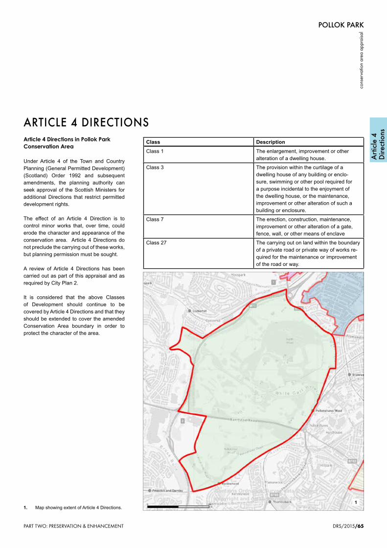
POLLOK PARK
cons
erva
tion
area
app
raisa
l
DRS/2015/65
Art
icle
4D
irect
ions
1. Map showing extent of Article 4 Directions.
Article 4 Directions in Pollok Park Conservation Area
Under Article 4 of the Town and Country Planning (General Permitted Development) (Scotland) Order 1992 and subsequent amendments, the planning authority can seek approval of the Scottish Ministers for additional Directions that restrict permitted development rights.
The effect of an Article 4 Direction is to control minor works that, over time, could erode the character and appearance of the conservation area. Article 4 Directions do not preclude the carrying out of these works, but planning permission must be sought.
A review of Article 4 Directions has been carried out as part of this appraisal and as required by City Plan 2.
It is considered that the above Classes of Development should continue to be covered by Article 4 Directions and that they should be extended to cover the amended Conservation Area boundary in order to protect the character of the area.
Class Description
Class 1 The enlargement, improvement or other alteration of a dwelling house.
Class 3 The provision within the curtilage of a dwelling house of any building or enclo-sure, swimming or other pool required for a purpose incidental to the enjoyment of the dwelling house, or the maintenance, improvement or other alteration of such a building or enclosure.
Class 7 The erection, construction, maintenance, improvement or other alteration of a gate, fence, wall, or other means of enclave
Class 27 The carrying out on land within the boundary of a private road or private way of works re-quired for the maintenance or improvement of the road or way.
ARTICLE 4 DIRECTIONS
1
Contains Ordnance Survey data © Crown copyright and database right, 2015
PART TWO: PRESERVATION & ENHANCEMENT

Pollok Park Conservation Area - Article 4 Directions
Class Description Class 1 The enlargement, improvement or other alteration of a dwellinghouse Class 3 The provision within the curtilage of a dwellinghouse of any building or enclosure, swimming or other
pool required for a purpose incidental to the enjoyment of the dwellinghouse, or the maintenance, improvement or other alteration of such a building or enclosure.
Class 7 The erection, construction, maintenance, improvement or alteration of a gate, fence, wall or other means of enclosure.
Class 27 The carrying out on land within the boundaries of a private road or private way of works required for the maintenance or improvement of the road or way.
(2) For the purpose of this class— “private road” has the meaning assigned to it by section 151(1) of the Roads (Scotland) Act 1984(2).
Class 16 The use of land, other than a building, as a caravan site in the circumstances referred to in sub-paragraph (3). (3) The circumstances specified in this sub-paragraph are those specified in paragraphs 2 to 10 of Schedule 1 to the 1960 Act, but in relation to those mentioned in paragraph 10 do not include use for winter quarters.
Class 17 Development required by the conditions of a site licence for the time being in force under the 1960 Act.
Class 18 The carrying out on agricultural land comprised in an agricultural unit of— (a) works for the erection, extension or alteration of a building; (b) the formation, alteration or maintenance of private ways; or (c) any excavation or engineering operations, requisite for the purposes of agriculture within that unit.
Class 20 The carrying out of any works required in connection with the improvement or maintenance of watercourses or land drainage works.
Class22 (1) The carrying out on land used for the purposes of forestry, including afforestation, or in the case of sub-paragraph (c) land held or occupied with that land, of development reasonably necessary for those purposes consisting of— (a) works for the erection, extension or alteration of a building; (b) the formation, alteration or maintenance of private ways; (c) operations on that land, or on land held or occupied with that land, to obtain the materials required for the formation, alteration or maintenance of such ways; (d) other operations (not including engineering or mining operations).
Class 27 (1) The carrying out on land within the boundaries of a private road or private way of works required for the maintenance or improvement of the road or way. (2) For the purpose of this class— “private road” has the meaning assigned to it by section 151(1) of the Roads (Scotland) Act 1984(2).
Class 30 The erection or construction and the maintenance, improvement or other alteration by a local authority of— (a) any building, works or equipment not exceeding 4 metres in height or 200 cubic metres in capacity on land belonging to or maintained by them, being building works or equipment required for the purposes of any function exercised by them on that land otherwise than as statutory undertakers;
POLLOK PARK
conservation area appraisal
66/DRS/2015
Bibliography/References
Select Bibliography
Country Life, 25 January 1913
Country Life, 13 October 1934
Crawford, George, A General Description of the Shire of Renfrew, 1710
Forman, Sheila, ‘Pollok House’ in Scottish Field, vol.103, 27 March 1955, pp. 36-7.
Fraser, Keith J. (Director of Parks, Glasgow), Landscape Appraisal, 1977
Fraser, William, Memoirs of the Maxwells of Pollok, 2 vols., 1863
Frew, M.C., Pollok, A Study of the History & Development of the Gardens, 1985, University of Sheffield (unpublished thesis).
Ferguson, Robert, Pollok House, (NTS Guidebook) 2014
Glasgow City Council, Pollok Country Park Management Plan 2011-16
Gow, Ian, ‘Pollok House, Glasgow: Recreating a Great Edwardian House’ in The Edwardian Great House (ed. Malcolm Airs)
Land Use Consultants, Pollok Estate Management Plan, 2002
McCallum, Andrew, Pollokshaws - Village and Burgh 1600-1912, 1925
McKinstry, Sam, Rowand Anderson: ‘The Premier Architect of Scotland’, 1991
Millar, A.H., Castles & Mansions in Renfrewshire,1889
Ramsay, P, Views in Renfrewshire, with Historical and Descriptive Notices, 1839.
Scott, Hew, Fasti Ecclesiae Scoticanae, vol.3, 1920.
BIBLIOGRAPHY & REFERENCESUseful Websites
Buildings at Riskwww.buildingsatrisk.org.uk
Dictionary of Scottish Architectswww.scottisharchitects.org.uk
Glasgow Archaeological Societywww.glasarchsoc.org.uk
The Glasgow Storywww.theglasgowstory.com
Historic Scotlandwww.historic-scotland.gov.uk
The Mitchell Librarywww.mitchelllibrary.org
National Archives of Scotlandwww.nas.gov.uk
National Library of Scotlandwww.nls.uk
Pastmapwww.pastmap.gov.uk
Royal Commission on the Ancient & Historical Monuments of Scotlandwww.rcahms.gov.uk
Scotland’s Placeswww.scotlandsplaces.gov.uk
Scottish Cultural Resources Access Network (SCRAN)www.scran.ac.uk
West of Scotland Archaeology Servicewww.wosas.net
Semple, William, History of the Shire of Renfrew, 1782
Smart, Aileen, Villages of Glasgow: South of the Clyde, 2002.
Small, Sam, RIAS Illustrated Architectural Guide to Greater Glasgow, 2008.
Smith, John Guthrie; Mitchell, John Oswald; Buchanan, John, The Old Country Houses of the Old Glasgow Gentry, 1878
Tait, A.A., ‘Pollok House’ in Country Life, July 24th 1980, p.309,
Weaver, Lawrence, ‘Pollok House, Renfrewshire’ in Country Life 25th January 1913, pp.126-133.
Williamson, Elizabeth; Anne Riches; & Malcolm Higgs, Buildings of Scotland: Glasgow, 1990.
PART THREE: GENERAL INFORMATION & APPENDICES
PART THREE: GENERAL INFORMATION & APPENDICES66
POLLOK PARK
conservation area appraisal
64/DRS/2015
Grants
GRANTSRepair Grants
Owners of historic buildings in Pollok Park Conservation Area may get help with the cost of repairs from the Glasgow City Heritage Trust and Historic Scotland. Eligible works include:-
• repair or reinstatement of original architectural features such as windows, decorative work and railings.
• repair of structural elements including masonry, roofs and joinery.
For further information contact:Glasgow City Heritage Trust50 Bell StreetGLASGOWG1 1LQt: 0141 552 [email protected]
CITY PLANPolicies
The quality and character of Pollok Park Conservation Area, as identified in this Appraisal, will be maintained through the implementation of policies contained within the adopted City Plan 2 (2009) and emerging City Development Plan 2015. The Development Policy Principles and the Design, Residential, Retail & Commercial Leisure and Environment Policies and accompanying guidance are of particular relevance.
Glasgow Building Preservation Trust was established in 1982 to rescue, repair, restore and rehabilitate historic buildings of architectural merit which through neglect or abuse may otherwise be lost in Glasgow and the surrounding area. The Trust also promotes educational opportunities (including traditional building skills), and organises the annual Doors Open Day event in Glasgow. Although the Trust is not a grant-giving body, in some cases it can provide information, advice and support for repair projects, and facilitate funding applications to other bodies.
For further information contact:Glasgow Building Preservation TrustRoom 16Wellpark Enterprise Centre120 Sydney StreetGLASGOWG31 1JFt: 0141 221 [email protected]
PART TWO: PRESERVATION & ENHANCEMENT

(b) lamp standards, refuse bins, public shelters and similar structures or works required in connection with the operation of any public service administered by them.
Class 31 The carrying out by a roads authority on land outwith but adjoining the boundary of an existing road of works required for or incidental to the maintenance or improvement of the road.
Class 34 (1) Development by railway undertakers or their lessees on their operational land, required in connection with the movement of traffic by rail.
Class 38 (1) For the purposes of water undertakings development of any of the following descriptions— (a) the laying underground of mains, pipes or other apparatus; (b) the installation in a water distribution system of a booster station, valve house, meter or switchgear house; (c) the provision of a building, plant, machinery or apparatus in, on, over or under land for the purpose of survey or investigation; (d) any other development carried out in, on, over or under the operational land other than the provision of a building but including the extension or alteration of a building.
Class 39 Development by a public gas supplier required for the purposes of its undertaking consisting of— (a) the laying underground of mains, pipes or other apparatus; (b) the installation in a gas distribution system of apparatus for measuring, recording, controlling or varying the pressure, flow or volume of gas, and structures for housing such apparatus; (c) the construction in any storage area or protective area specified in an order made under section 4 of the Gas Act 1965(7), of boreholes, and the erection or construction in any such area of any plant or machinery required in connection with the construction of such boreholes; (d) the placing and storage on land of pipes and other apparatus to be included in a main pipe which is being or is about to be laid or constructed in pursuance of planning permission granted or deemed to be granted under Part III of the Act; (e) the erection on operational land of the public gas supplier of a building solely for the protection of plant or machinery; and (f) any other development carried out in, on, over or under the operational land of the public gas supplier.
Class 40 (1) Development by statutory undertakers for the generation, transmission or supply of electricity for the purposes of their undertaking consisting of— (a) the installation or replacement in, on, over or under land of an electric line and the construction of shafts and tunnels and the installation or replacement of feeder or service pillars or transfor ming or switching stations or chambers reasonably necessary in connection with an electric line; (b) the installation or replacement of any telecommunications line which connects any part of an electric line to any electrical plant or building, and the installation or replacement of any support for any such line; (c) the sinking of boreholes to ascertain the nature of the subsoil and the installation of any plant or
POLLOK PARK
cons
erva
tion
area
app
raisa
l
DRS/2015/67
Bibl
iogr
aphy
/Re
fere
nces
1. Wrought-iron baluster to Pollok House.
1
PART THREE: GENERAL INFORMATION & APPENDICES
POLLOK PARK
cons
erva
tion
area
app
raisa
l
DRS/2015/65
Art
icle
4D
irect
ions
1. Map showing extent of Article 4 Directions.
Article 4 Directions in Pollok Park Conservation Area
Under Article 4 of the Town and Country Planning (General Permitted Development) (Scotland) Order 1992 and subsequent amendments, the planning authority can seek approval of the Scottish Ministers for additional Directions that restrict permitted development rights.
The effect of an Article 4 Direction is to control minor works that, over time, could erode the character and appearance of the conservation area. Article 4 Directions do not preclude the carrying out of these works, but planning permission must be sought.
A review of Article 4 Directions has been carried out as part of this appraisal and as required by City Plan 2.
It is considered that the above Classes of Development should continue to be covered by Article 4 Directions and that they should be extended to cover the amended Conservation Area boundary in order to protect the character of the area.
Class Description
Class 1 The enlargement, improvement or other alteration of a dwelling house.
Class 3 The provision within the curtilage of a dwelling house of any building or enclo-sure, swimming or other pool required for a purpose incidental to the enjoyment of the dwelling house, or the maintenance, improvement or other alteration of such a building or enclosure.
Class 7 The erection, construction, maintenance, improvement or other alteration of a gate, fence, wall, or other means of enclave
Class 27 The carrying out on land within the boundary of a private road or private way of works re-quired for the maintenance or improvement of the road or way.
ARTICLE 4 DIRECTIONS
1
Contains Ordnance Survey data © Crown copyright and database right, 2015
PART TWO: PRESERVATION & ENHANCEMENT
POLLOK PARK
cons
erva
tion
area
app
raisa
l
DRS/2015/65
Art
icle
4D
irect
ions
1. Map showing extent of Article 4 Directions.
Article 4 Directions in Pollok Park Conservation Area
Under Article 4 of the Town and Country Planning (General Permitted Development) (Scotland) Order 1992 and subsequent amendments, the planning authority can seek approval of the Scottish Ministers for additional Directions that restrict permitted development rights.
The effect of an Article 4 Direction is to control minor works that, over time, could erode the character and appearance of the conservation area. Article 4 Directions do not preclude the carrying out of these works, but planning permission must be sought.
A review of Article 4 Directions has been carried out as part of this appraisal and as required by City Plan 2.
It is considered that the above Classes of Development should continue to be covered by Article 4 Directions and that they should be extended to cover the amended Conservation Area boundary in order to protect the character of the area.
Class Description
Class 1 The enlargement, improvement or other alteration of a dwelling house.
Class 3 The provision within the curtilage of a dwelling house of any building or enclo-sure, swimming or other pool required for a purpose incidental to the enjoyment of the dwelling house, or the maintenance, improvement or other alteration of such a building or enclosure.
Class 7 The erection, construction, maintenance, improvement or other alteration of a gate, fence, wall, or other means of enclave
Class 27 The carrying out on land within the boundary of a private road or private way of works re-quired for the maintenance or improvement of the road or way.
ARTICLE 4 DIRECTIONS
1
Contains Ordnance Survey data © Crown copyright and database right, 2015
PART TWO: PRESERVATION & ENHANCEMENT 67

machinery reasonably necessary in connection with such boreholes; (d) the extension or alteration of buildings on operational land of the undertaking; (e) the erection on operational land of the undertaking of a building solely for the protection of plant or machinery; and (f) any other development carried out in, on, over or under the operational land of the undertaking.
Class 41 (1) Development required for the purposes of the carrying on of any tramway or road transport undertaking consisting of— (a) the installation of posts, overhead wires, underground cables, feeder pillars or transformer boxes in, on, over or adjacent to a road for the purpose of supplying current to public service vehicles; (b) the installation of tramway tracks, and conduits, drains and pipes in connection with such tracks for the working of tramways; (c) the installation of telephone cables and apparatus, huts, stop posts and signs required in connection with the operation of public service vehicles; (d) the erection or construction and the maintenance, improvement or other alteration of passenger shelters and barriers for the control of people waiting to enter public service vehicles; (e) any other development on operational land of the undertaking.
Class 43 (1) Development required for the purposes of the Post Office consisting of— (a) the installation of posting boxes, posting pouches or self-service machines; (b) any other development carried out in, on, over or under the operational land of the undertaking.
Class 53 (1) Development on any land during a period not exceeding 28 consecutive days consisting of— (a) the drilling of boreholes; (b) the carrying out of seismic surveys; or (c) the making of other excavations,for the purpose of mineral exploration, and the provision or assembly on that land or adjoining land of any structure required in connection with any of those operations.
Class 55 (1) The carrying out of operations for the erection, extension, installation, rearrangement, replacement, repair or other alteration of any— (a) plant or machinery; (b) buildings; (c) private ways or private railways or sidings; or (d) sewers, mains, pipes, cables or other similar apparatus, on land used as a mine.
Class 67 (1) Development by or on behalf of a telecommunications code system operator for the purpose of the operator’s telecommunication system in, on, over or under land controlled by that operator or in
POLLOK PARK
conservation area appraisal
66/DRS/2015
Bibliography/References
Select Bibliography
Country Life, 25 January 1913
Country Life, 13 October 1934
Crawford, George, A General Description of the Shire of Renfrew, 1710
Forman, Sheila, ‘Pollok House’ in Scottish Field, vol.103, 27 March 1955, pp. 36-7.
Fraser, Keith J. (Director of Parks, Glasgow), Landscape Appraisal, 1977
Fraser, William, Memoirs of the Maxwells of Pollok, 2 vols., 1863
Frew, M.C., Pollok, A Study of the History & Development of the Gardens, 1985, University of Sheffield (unpublished thesis).
Ferguson, Robert, Pollok House, (NTS Guidebook) 2014
Glasgow City Council, Pollok Country Park Management Plan 2011-16
Gow, Ian, ‘Pollok House, Glasgow: Recreating a Great Edwardian House’ in The Edwardian Great House (ed. Malcolm Airs)
Land Use Consultants, Pollok Estate Management Plan, 2002
McCallum, Andrew, Pollokshaws - Village and Burgh 1600-1912, 1925
McKinstry, Sam, Rowand Anderson: ‘The Premier Architect of Scotland’, 1991
Millar, A.H., Castles & Mansions in Renfrewshire,1889
Ramsay, P, Views in Renfrewshire, with Historical and Descriptive Notices, 1839.
Scott, Hew, Fasti Ecclesiae Scoticanae, vol.3, 1920.
BIBLIOGRAPHY & REFERENCESUseful Websites
Buildings at Riskwww.buildingsatrisk.org.uk
Dictionary of Scottish Architectswww.scottisharchitects.org.uk
Glasgow Archaeological Societywww.glasarchsoc.org.uk
The Glasgow Storywww.theglasgowstory.com
Historic Scotlandwww.historic-scotland.gov.uk
The Mitchell Librarywww.mitchelllibrary.org
National Archives of Scotlandwww.nas.gov.uk
National Library of Scotlandwww.nls.uk
Pastmapwww.pastmap.gov.uk
Royal Commission on the Ancient & Historical Monuments of Scotlandwww.rcahms.gov.uk
Scotland’s Placeswww.scotlandsplaces.gov.uk
Scottish Cultural Resources Access Network (SCRAN)www.scran.ac.uk
West of Scotland Archaeology Servicewww.wosas.net
Semple, William, History of the Shire of Renfrew, 1782
Smart, Aileen, Villages of Glasgow: South of the Clyde, 2002.
Small, Sam, RIAS Illustrated Architectural Guide to Greater Glasgow, 2008.
Smith, John Guthrie; Mitchell, John Oswald; Buchanan, John, The Old Country Houses of the Old Glasgow Gentry, 1878
Tait, A.A., ‘Pollok House’ in Country Life, July 24th 1980, p.309,
Weaver, Lawrence, ‘Pollok House, Renfrewshire’ in Country Life 25th January 1913, pp.126-133.
Williamson, Elizabeth; Anne Riches; & Malcolm Higgs, Buildings of Scotland: Glasgow, 1990.
PART THREE: GENERAL INFORMATION & APPENDICES
PART THREE: GENERAL INFORMATION & APPENDICES68
POLLOK PARK
conservation area appraisal
64/DRS/2015
Grants
GRANTSRepair Grants
Owners of historic buildings in Pollok Park Conservation Area may get help with the cost of repairs from the Glasgow City Heritage Trust and Historic Scotland. Eligible works include:-
• repair or reinstatement of original architectural features such as windows, decorative work and railings.
• repair of structural elements including masonry, roofs and joinery.
For further information contact:Glasgow City Heritage Trust50 Bell StreetGLASGOWG1 1LQt: 0141 552 [email protected]
CITY PLANPolicies
The quality and character of Pollok Park Conservation Area, as identified in this Appraisal, will be maintained through the implementation of policies contained within the adopted City Plan 2 (2009) and emerging City Development Plan 2015. The Development Policy Principles and the Design, Residential, Retail & Commercial Leisure and Environment Policies and accompanying guidance are of particular relevance.
Glasgow Building Preservation Trust was established in 1982 to rescue, repair, restore and rehabilitate historic buildings of architectural merit which through neglect or abuse may otherwise be lost in Glasgow and the surrounding area. The Trust also promotes educational opportunities (including traditional building skills), and organises the annual Doors Open Day event in Glasgow. Although the Trust is not a grant-giving body, in some cases it can provide information, advice and support for repair projects, and facilitate funding applications to other bodies.
For further information contact:Glasgow Building Preservation TrustRoom 16Wellpark Enterprise Centre120 Sydney StreetGLASGOWG31 1JFt: 0141 221 [email protected]
PART TWO: PRESERVATION & ENHANCEMENT

accordance with his license, consisting of— (a) the installation, alteration or replacement of any telecommunication apparatus; (b) the use of land in an emergency for a period not exceeding 6 months to station and operate moveable telecommunication apparatus required for the replacement of unserviceable telecommunication apparatus, including the provision of moveable structures on the land for the purposes of that use; (c) the use of land for a period of six months for the purpose of erecting temporary buildings for housing moveable telecommunication apparatus all in connection with development authorised by a grant of planning permission; or (d) any building, works or equipment not exceeding 4 metres in height or 200 cubic metres in capacity.
POLLOK PARK
cons
erva
tion
area
app
raisa
l
DRS/2015/67
Bibl
iogr
aphy
/Re
fere
nces
1. Wrought-iron baluster to Pollok House.
1
PART THREE: GENERAL INFORMATION & APPENDICES
POLLOK PARK
cons
erva
tion
area
app
raisa
l
DRS/2015/65
Art
icle
4D
irect
ions
1. Map showing extent of Article 4 Directions.
Article 4 Directions in Pollok Park Conservation Area
Under Article 4 of the Town and Country Planning (General Permitted Development) (Scotland) Order 1992 and subsequent amendments, the planning authority can seek approval of the Scottish Ministers for additional Directions that restrict permitted development rights.
The effect of an Article 4 Direction is to control minor works that, over time, could erode the character and appearance of the conservation area. Article 4 Directions do not preclude the carrying out of these works, but planning permission must be sought.
A review of Article 4 Directions has been carried out as part of this appraisal and as required by City Plan 2.
It is considered that the above Classes of Development should continue to be covered by Article 4 Directions and that they should be extended to cover the amended Conservation Area boundary in order to protect the character of the area.
Class Description
Class 1 The enlargement, improvement or other alteration of a dwelling house.
Class 3 The provision within the curtilage of a dwelling house of any building or enclo-sure, swimming or other pool required for a purpose incidental to the enjoyment of the dwelling house, or the maintenance, improvement or other alteration of such a building or enclosure.
Class 7 The erection, construction, maintenance, improvement or other alteration of a gate, fence, wall, or other means of enclave
Class 27 The carrying out on land within the boundary of a private road or private way of works re-quired for the maintenance or improvement of the road or way.
ARTICLE 4 DIRECTIONS
1
Contains Ordnance Survey data © Crown copyright and database right, 2015
PART TWO: PRESERVATION & ENHANCEMENT
POLLOK PARK
cons
erva
tion
area
app
raisa
l
DRS/2015/65
Art
icle
4D
irect
ions
1. Map showing extent of Article 4 Directions.
Article 4 Directions in Pollok Park Conservation Area
Under Article 4 of the Town and Country Planning (General Permitted Development) (Scotland) Order 1992 and subsequent amendments, the planning authority can seek approval of the Scottish Ministers for additional Directions that restrict permitted development rights.
The effect of an Article 4 Direction is to control minor works that, over time, could erode the character and appearance of the conservation area. Article 4 Directions do not preclude the carrying out of these works, but planning permission must be sought.
A review of Article 4 Directions has been carried out as part of this appraisal and as required by City Plan 2.
It is considered that the above Classes of Development should continue to be covered by Article 4 Directions and that they should be extended to cover the amended Conservation Area boundary in order to protect the character of the area.
Class Description
Class 1 The enlargement, improvement or other alteration of a dwelling house.
Class 3 The provision within the curtilage of a dwelling house of any building or enclo-sure, swimming or other pool required for a purpose incidental to the enjoyment of the dwelling house, or the maintenance, improvement or other alteration of such a building or enclosure.
Class 7 The erection, construction, maintenance, improvement or other alteration of a gate, fence, wall, or other means of enclave
Class 27 The carrying out on land within the boundary of a private road or private way of works re-quired for the maintenance or improvement of the road or way.
ARTICLE 4 DIRECTIONS
1
Contains Ordnance Survey data © Crown copyright and database right, 2015
PART TWO: PRESERVATION & ENHANCEMENT 69

POLLOK PARK
conservation area appraisal
66/DRS/2015
Bibliography/References
Select Bibliography
Country Life, 25 January 1913
Country Life, 13 October 1934
Crawford, George, A General Description of the Shire of Renfrew, 1710
Forman, Sheila, ‘Pollok House’ in Scottish Field, vol.103, 27 March 1955, pp. 36-7.
Fraser, Keith J. (Director of Parks, Glasgow), Landscape Appraisal, 1977
Fraser, William, Memoirs of the Maxwells of Pollok, 2 vols., 1863
Frew, M.C., Pollok, A Study of the History & Development of the Gardens, 1985, University of Sheffield (unpublished thesis).
Ferguson, Robert, Pollok House, (NTS Guidebook) 2014
Glasgow City Council, Pollok Country Park Management Plan 2011-16
Gow, Ian, ‘Pollok House, Glasgow: Recreating a Great Edwardian House’ in The Edwardian Great House (ed. Malcolm Airs)
Land Use Consultants, Pollok Estate Management Plan, 2002
McCallum, Andrew, Pollokshaws - Village and Burgh 1600-1912, 1925
McKinstry, Sam, Rowand Anderson: ‘The Premier Architect of Scotland’, 1991
Millar, A.H., Castles & Mansions in Renfrewshire,1889
Ramsay, P, Views in Renfrewshire, with Historical and Descriptive Notices, 1839.
Scott, Hew, Fasti Ecclesiae Scoticanae, vol.3, 1920.
BIBLIOGRAPHY & REFERENCESUseful Websites
Buildings at Riskwww.buildingsatrisk.org.uk
Dictionary of Scottish Architectswww.scottisharchitects.org.uk
Glasgow Archaeological Societywww.glasarchsoc.org.uk
The Glasgow Storywww.theglasgowstory.com
Historic Scotlandwww.historic-scotland.gov.uk
The Mitchell Librarywww.mitchelllibrary.org
National Archives of Scotlandwww.nas.gov.uk
National Library of Scotlandwww.nls.uk
Pastmapwww.pastmap.gov.uk
Royal Commission on the Ancient & Historical Monuments of Scotlandwww.rcahms.gov.uk
Scotland’s Placeswww.scotlandsplaces.gov.uk
Scottish Cultural Resources Access Network (SCRAN)www.scran.ac.uk
West of Scotland Archaeology Servicewww.wosas.net
Semple, William, History of the Shire of Renfrew, 1782
Smart, Aileen, Villages of Glasgow: South of the Clyde, 2002.
Small, Sam, RIAS Illustrated Architectural Guide to Greater Glasgow, 2008.
Smith, John Guthrie; Mitchell, John Oswald; Buchanan, John, The Old Country Houses of the Old Glasgow Gentry, 1878
Tait, A.A., ‘Pollok House’ in Country Life, July 24th 1980, p.309,
Weaver, Lawrence, ‘Pollok House, Renfrewshire’ in Country Life 25th January 1913, pp.126-133.
Williamson, Elizabeth; Anne Riches; & Malcolm Higgs, Buildings of Scotland: Glasgow, 1990.
PART THREE: GENERAL INFORMATION & APPENDICES
PART THREE: GENERAL INFORMATION & APPENDICES70

POLLOK PARK
cons
erva
tion
area
app
raisa
l
DRS/2015/67
Bibl
iogr
aphy
/Re
fere
nces
1. Wrought-iron baluster to Pollok House.
1
PART THREE: GENERAL INFORMATION & APPENDICES 71

POLLOK PARK
conservation area appraisal
68/DRS/2015
Further Inform
ation
FURTHER INFORMATION
1. Pollok House from the bowling green to the south-east.
Useful Publications
The adopted Glasgow City Plan 2 (2009) is available on the Council’s website. It sets out all the policies and accompanying guidance designed to protect and enhance the historic and natural environment of the conservation area.www.glasgow.gov.ukand follow the linksBusinessCity Plan 2
Useful Contacts
For all planning, conservation, landscape, tree, building control and public safety related enquiries:Planning and Building ControlTel: 0141 287 8555.www.glasgow.gov.uk
For grant enquiries:Glasgow City Heritage TrustTel: 0141 552 1331www.glasgowheritage.org.uk
Additional enquiries:Historic ScotlandTel: 0131 668 8600www.historic-scotland.gov.uk
Historic Scotland Technical Conservation Group’s series of INFORM Guides, is available from Historic Scotland or can be downloaded from their website. These are short leaflets that give owners of traditional buildings information on repair and maintenance.www.his tor ic-scot land.gov.uk/ index/learning/freepublications.htm
Historic Scotland’s Guide to the Protection of Scotland’s Listed Buildings (2009) is available from the same address.
1
PART THREE: GENERAL INFORMATION & APPENDICES
Additional enquiries:Historic Environment ScotlandTel: 0131 668 8600www.historic-scotland.gov.uk
POLLOK PARK
conservation area appraisal
68/DRS/2015
Further Inform
ation
FURTHER INFORMATION
1. Pollok House from the bowling green to the south-east.
Useful Publications
The adopted Glasgow City Plan 2 (2009) is available on the Council’s website. It sets out all the policies and accompanying guidance designed to protect and enhance the historic and natural environment of the conservation area.www.glasgow.gov.ukand follow the linksBusinessCity Plan 2
Useful Contacts
For all planning, conservation, landscape, tree, building control and public safety related enquiries:Planning and Building ControlTel: 0141 287 8555.www.glasgow.gov.uk
For grant enquiries:Glasgow City Heritage TrustTel: 0141 552 1331www.glasgowheritage.org.uk
Additional enquiries:Historic ScotlandTel: 0131 668 8600www.historic-scotland.gov.uk
Historic Scotland Technical Conservation Group’s series of INFORM Guides, is available from Historic Scotland or can be downloaded from their website. These are short leaflets that give owners of traditional buildings information on repair and maintenance.www.his tor ic-scot land.gov.uk/ index/learning/freepublications.htm
Historic Scotland’s Guide to the Protection of Scotland’s Listed Buildings (2009) is available from the same address.
1
PART THREE: GENERAL INFORMATION & APPENDICES
www.historic-scotland.gov.uk/index/learning/freepublications.htm
Historic Environment ScotlandGuide to the Protection to Scotland’sL i s t e d B uildings (2009)from the same address.
72

For further information and advice relating to conservation areas or heritage issues generally contact:
Planning and Building ControlDevelopment and Regeneration Services
Glasgow City Council229 George Street
GLASGOWG1 1QU
Phone: 0141 287 8555
This publication can be provided in a variety of formats.

Planning and Building ControlDevelopment and Regeneration Services
Glasgow City Council229 George Street
GLASGOWG1 1QU