Planning, “Violations,” & Urban Inclusion: A Study of ...
59
May 2017 Planning, “Violations,” & Urban Inclusion: A Study of Bhubaneswar Authors: Geetika Anand and Anushree Deb Reviewer: Gautam Bhan | Research Support: Abhinav M
Transcript of Planning, “Violations,” & Urban Inclusion: A Study of ...

May 2017
Planning, “Violations,” & Urban Inclusion: A Study of Bhubaneswar
Authors: Geetika Anand and Anushree Deb
Reviewer: Gautam Bhan | Research Support: Abhinav M

Layout and Design: Nawaz Khan
Maps: Lokesh B.S.

Table of Contents
List of Figures……………………………………………………………………………………………………………….…ii
List of Tables………………………………………………..…………………………………………………………………ii
List of Maps…………………………………………………………………………………………………………………….ii
Abbreviations Used..…………………………………………………………………………………………………......iii
1. Introduction: Why study violations? ....................................................................................... 1
2. Urbanisation in Odisha .............................................................................................................. 3
3. Bhubaneswar ............................................................................................................................... 5
3.1. Brief Overview ..................................................................................................................... 5
3.2. Master Plans of Bhubaneswar ......................................................................................... 5
3.3. Other Plans for Bhubaneswar.......................................................................................... 6
4. Research Objectives and Methodology ................................................................................. 7
4.1. Objective ............................................................................................................................... 7
4.2. Methodology ........................................................................................................................ 7
4.3. Scope, Limitations and Challenges ................................................................................. 8
5. Key Findings & Analysis ............................................................................................................. 9
5.2. Characteristics of Unauthorised Slums........................................................................ 12
5.3. Characteristics of Authorised Slums ............................................................................. 12
6. Master Plan, Slums and Violations ........................................................................................ 14
6.1. Understanding Land Use Violations: Overlay Analysis ............................................. 14
6.2. Master Plan and Housing for the Urban Poor ............................................................ 17
7. Conclusion .................................................................................................................................. 20
References .......................................................................................................................................... 22
Annex 1: Case Stories ....................................................................................................................... 23
Annex 2: Land Uses Permitted, Permitted under Special Consideration & Prohibited in
Different Use Zones ......................................................................................................................... 35
i

List of Figures
Fig. 1: Population Growth in Odisha……………………………………………………………………….………3
Fig. 2: Growth of Population in Bhubaneswar, 1971 – 2011……………………………………………5
List of Tables
Table 1: Slums in Bhubaneswar………………………………………………………………………………………9
Table 2: Tenurial Details of Sample Slums ……………………………………………………………………12
Table 3: Tenurial Details of Sample Authorised Slums………………………………………………….13
Table 4: Overlay Analysis of Existing Land Use and Recognised Slums ………………………..14
Table 5: Existing Land Use vs. Tenurial Rights ………………………………………………………………14
Table 6: Overlay Analysis of Proposed Land Use and Recognised Slums………………………16
Table 7: Proposed Land Use vs. Tenurial Rights.…………………………………………………………..16
List of Maps
Map 1: Settlement Structure of Odisha, 2011…………………………………………………………………4
Map 2: Location of Recognised Slums in Bhubaneswar………………………………………..………10
Map 3: Location of Sample Slums in Bhubaneswar………………………………………………………11
Map 4: Existing Land Use of Bhubaneswar, 2010 with Recognised Slums.……………………18
Map 5: Proposed Land Use of Bhubaneswar, 2030 with Recognised Slums…………………19
ii

Abbreviations Used
AMRUT Atal Mission for Rejuvenation and Urban Transformation
BCUC Bhubaneswar Cuttack Urban Complex
BDA Bhubaneswar Development Authority
BDPA Bhubaneswar Development Plan Area
BMC Bhubaneswar Municipal Corporation
BSUP Basic Services for Urban Poor
CDP Comprehensive Development Plan
ELU Existing Land Use
EWS Economically Weaker Sections
HH Household
IIT Indian Institute of Technology
JnNURM Jawaharlal Nehru National Urban Renewal Mission
LIG Lower Income Group
PHED Public Health and Engineering Department
PLU Proposed Land Use
SLIP Service Level Improvement Plan
Sq. Km. Square Kilometre
SRDP Slum Rehabilitation and Development Policy
ULB Urban Local Body
iii


1
1. Introduction: Why study violations?
In many cities of the world, particularly those in the global south, patterns of
inhabitation and settling do not follow the logics or the laws of planning. From the
favelas in Rio to the bastis in Delhi, the musseques in Luanda or the shacks in Durban, a
significant part of these cities are built by residents themselves, often in some tension
with law and planning. Teresa Caldeira has described this shared process of city-
building as “auto-construction” (Caldiera, 2014). Too often, auto-construction is
misrecognised simply as the “failure” and “violation” of planning, what in the Indian
landscape is called an “implementation gap.” Yet how should we understand “violation”
and “failure” when it is done often by the city’s poorest residents as a claim to the city
and shelter? How can we understand an “encroachment” or “illegal” act if it is done by
such a large proportion of city residents? Indeed, what does the fact that are cities are
auto-constructed tell us about planning? How should planning respond to such
“violations” that combine both the difficulty of orderly urban development with
concerns for urban equity and inclusion?
This set of reports seek to help find answers to such questions by undertaking literature
review, and studying the nature, kind and quantum of violations in two Indian cities –
Ranchi and Bhubaneswar. We do so in order to understand better and in-depth what
kinds of violations occur in cities. We hope to de-mystify and unpack this broad category
that, within it, encompasses a range of ways of settling and surviving in the auto-
constructed. We intend to better assess both the reasons that these violations become
necessary as well as to think about how planning can engage with them. Doing so, we
argue, is essential to understand the relationship between planning and urban inclusion
in Indian cities.
This report presents the observations and findings from Bhubaneswar. We chose
Bhubaneswar because for a city developed as a ‘planned’ one, Bhubaneswar has a high
proportion of ‘slum’ population. It represents a mid-size city that secured first position
in the Smart Cities mission. The city is precariously poised. On the one hand, it has a
new impetus for growth and change. On the other, the scalar shift it is about to make
will bring new challenges for urban planning, governance, management and,
specifically, inclusion. Mid-size cities across India face this transition but each still has
the potential for transformation and early responses to inequality that mega-cities like
Delhi and Mumbai can no longer access. Can understanding “violations” be one part of
tilting the urbanization of the Indian mid-size city towards a more inclusive growth
pattern?
The report proceeds as follows. First, we briefly locate the context of Odisha’s
urbanisation and then present an overview of Bhubaneswar. Then, we look closely in

2
Bhubaneswar at one kind of violation– the “slum.” In doing so, we do not imply that
violations are solely done by slums – like all Indian cities, violations are much the
domain of the elite (Bhan 2013). We focus on the “slum” because it is the kind of
violation most closely related with urban vulnerability and represents a governmental
category recognisable within urban governance in India. We argue that it is essential to
dis-aggregate the category of “slum” into the varied historical, spatial and legal forms of
settlement that are within this category. We do so by first mapping slums against
Bhubaneswar’s Master Plans to assess the precise nature of the violation at hand and
then drawing a typology of differential vulnerability and distance from formal planning.
In conclusion, we suggest how to understand these “violations,” and how to frame the
engagement between slums, “violations” and Master Plans.
3
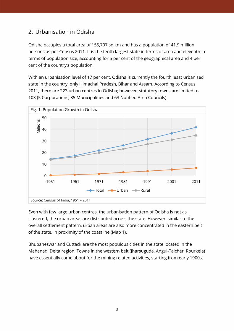
2. Urbanisation in Odisha
Odisha occupies a total area of 155,707 sq.km and has a population of 41.9 million
persons as per Census 2011. It is the tenth largest state in terms of area and eleventh in
terms of population size, accounting for 5 per cent of the geographical area and 4 per
cent of the country’s population.
With an urbanisation level of 17 per cent, Odisha is currently the fourth least urbanised
state in the country, only Himachal Pradesh, Bihar and Assam. According to Census
2011, there are 223 urban centres in Odisha; however, statutory towns are limited to
103 (5 Corporations, 35 Municipalities and 63 Notified Area Councils).
Fig. 1: Population Growth in Odisha
Source: Census of India, 1951 – 2011
Even with few large urban centres, the urbanisation pattern of Odisha is not as
clustered; the urban areas are distributed across the state. However, similar to the
overall settlement pattern, urban areas are also more concentrated in the eastern belt
of the state, in proximity of the coastline (Map 1).
Bhubaneswar and Cuttack are the most populous cities in the state located in the
Mahanadi Delta region. Towns in the western belt (Jharsuguda, Angul-Talcher, Rourkela)
have essentially come about for the mining related activities, starting from early 1900s.
0
10
20
30
40
50
1951 1961 1971 1981 1991 2001 2011
Millio
ns
Total Urban Rural
Railway Line
National Highway
Ward Boundary
BMC Boundary
Slums with Tenure
Vegetation/Forest Land
Water Body
Legend
Source: Slum information collected from BMC, 2016; IIHS Analysis, 2016-17.
0 2KM
Slums with no Tenure
Datum: WGS 84Projection: UTM 44 N
Source(s):Census of India, 2011; OpenStreet Maps; IIHS Analysis
Key Map and Legend
State Boundary
Major City
Population Size Classes:
WEST BENGALJHARKHAND
CHHATTISGARH
ANDHRA PRADESH
BAY OF BENGAL
Visakhapatnam
Berhampur
Rayagada
Raipur
Sambalpur
Jharsuguda
Raurkela
Jamshedpur
Kharagpur
Bhadrak
ParadipBhubaneswar
Cuttack
Anugul
Balangir
Balasore
Jeypore
Titilagarh
Class I city
Class II town
Class III town
Class IV, V or VI town
Very large village
Large village
Medium village
Small village
Hamlet or smaller
Map 1: Settlement Structure of Odisha, 2011
N 0 50 100 150KM

5
3. Bhubaneswar
3.1. Brief Overview
Categorised as a tier-2 city, Bhubaneswar replaced Cuttack as the capital of Odisha in
1949. Designed by Otto Königsberger in 1946, Bhubaneswar along with Jamshedpur and
Chandigarh is known as one of India's first planned cities. Due to the presence of the
reserve forests in the north-western part and the flood plains in the eastern part, the
city has grown more towards the southwestern side.
Currently, the Bhubaneswar Municipal Corporation spreads over an area of 135 sq. km.
covering 67 administrative wards. According to Census 2011, the city has a population
of 8,85,363 people with a ‘slum’ population of 1,63,983 people (18.5 per cent).
Fig. 2: Growth of Population in Bhubaneswar, 1971 – 2011
Source: Census of India, various years; IIHS Analysis, 2015.
Bhubaneswar is, in a sense, a tale of three cities; there is old city around the temple
which was in existence before the shifting of the capital, then there is planned capital
city, and now increasingly there is ‘unplanned’ development all around.
3.2. Master Plans of Bhubaneswar
Otto Königsberger drafted the first Master Plan for Bhubaneswar in 1954 with the
intention of housing not more than 40,000 people and administration being city’s
primary function. At the time, it comprised of six administrative units, and the other
units were planned as residential neighbourhoods with emphasis on horizontal rather
than vertical growth. The Bhubaneswar Development Authority was established in the
year 1983 and currently it covers an area of 233 sq. km. including Khorda and Jatani
0%
2%
4%
6%
8%
10%
0
0.2
0.4
0.6
0.8
1
1971 1981 1991 2001 2011
CA
GR
Po
pu
lati
on
Millio
n
Census Year
Population CAGR

6
Municipalities as well. An Interim Development Plan for Bhubaneswar was formulated
in 1993. Currently, the Perspective Plan – 2030 for the Bhubaneswar Cuttack Urban
Complex (BCUC) exists which was prepared by the Department of Architecture and
Regional Planning, IIT-Kharagpur in 2006. The Comprehensive Development Plan for
Bhubaneswar Development Planning Area (BDPA) has been formulated within the
framework of Perspective Plan in 2010, again with the support of IIT-Kharagpur. The
BDPA constitutes around 58 per cent of the BCUC area and extends over 419.10 sq.km.
against 721.9 sq. km of the BCUC area. BDPA has been formed by amalgamating BMC,
BDPA Rural, Khorda and Jatani.
3.3. Other Plans for Bhubaneswar
There are a number of other plans that exist for Bhubaneswar which are not statutory
in nature but mostly prepared under a central or state scheme with funding for
implementation. Under the Jawaharlal Nehru National Urban Renewal Mission
(JNNURM), the City Development Plan for Bhubaneswar was prepared. More recently,
Service Level Improvement Plans (SLIPs) for 9 cities in Odisha including Bhubaneswar
are being prepared under the Atal Mission of Rejuvenation and Urban Transformation
(AMRUT). Bhubaneswar secured first rank in the first phase of Smart Cities Mission.
Under this mission, a SMART Bhubaneswar Town District Centre covering an area of 985
Acres is proposed. In order to achieve Housing for All, AWAAS (Odisha Urban Housing
Mission) was also launched in 2015.

7
4. Research Objectives and Methodology
4.1. Objective
The underlying aim of the research was to study informal settlements, authorised and
unauthorised in the context of the existing Master Plan.
The specific objectives of the study included:
1. Mapping informal settlements with special emphasis on authorised and
unauthorised ‘slums’;
2. Developing a typology of ‘slums’, especially authorised slums, with respect to their
tenurial arrangements;
3. Analysing existing and proposed Master Plan provisions for the land occupied by
authorised and unauthorised ‘slums’.
4.2. Methodology
1. Secondary Data Collection & Review: Prior to fieldwork, a thorough secondary
review was conducted to gather any information available. A slum listing done by
the Bhubaneswar Municipal Corporation was found. Though disaggregated by
authorised and un-authorised, the list did not provide any further information on
the existing tenurial situation of slums.
2. Database Creation: The existing slum list was georeferenced to create a
comprehensive spatial database.
3. Ground Truthing, Validation & Profiling: Since the slum list gave no further
information on the slums settlements other than the ward number, number of
households and total population of each slum, it was important to undertake
primary fieldwork. A sample of 88 slums out of 436 were visited to create a
comprehensive profile, with an effort to maintain geographical spread and a balance
between authorised and un-authorised slums. In addition, transit housing and
resettlement sites were also visited. The information recorded is on the basis of self-
reporting by a group of residents in each basti. A minimum of three to four residents
were questioned in each basti to triangulate information and eliminate individual
bias. Due to time constraints, only parts of the slums were visited; in case of large
slums, only some of the characteristics may differ.
4. Typology Development: A typology of slums was developed on the basis of the self-
reported status of land and tenurial rights in the slum. This was crucial in
understanding the further sub-divisions of authorized slums in the city. Two clear

8
categories emerged as a result of this: Unauthorised Slums that have no tenurial
rights (primarily on government land) and Authorised Slums that have some form of
record over their houses and land.
5. Overlay Analysis with Land Use Maps: Overlay analysis of the slum map was done
with the existing and proposed land use plans to identify instances and nature of
violations.
4.3. Scope, Limitations and Challenges
1. Due to resource and time constraints, only a sample of ‘slums’ could be visited for
ground truthing and understanding tenurial arrangements.
2. Again, due to resource and time constraints, existing list of ‘slums’ was used; no new
surveys to identify ‘slum-like’ settlements were done.
3. Since the raster images of existing and proposed land use maps were manually
georeferenced and digitised, there may be some mismatch in the overlay analysis
between the maps and the actual condition on ground.

9
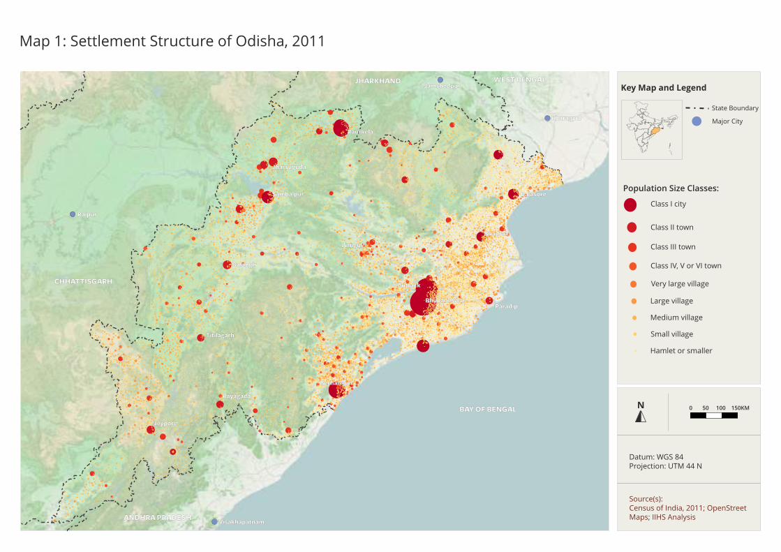
5. Key Findings & Analysis
5.1. Slums in Bhubaneswar
There are 436 recognised slum settlements in Bhubaneswar (identified by the Municipal
Corporation) of which 320 (73 per cent) are unauthorised and 116 (27 per cent) are
authorised1 (Map 2). The total slum population is of the order of 3,01,611 lakh persons
or 80,665 households. The geographic area of the slums ranges from 0.045 hectares to
18.31 hectares, the smallest being Radha Krishna Basti in ward 45 and the largest being
Khandagiri Bari in ward 23. The number of households in the slums also vary, from as
low as 13 in Rangamatia Basti in ward 9 to as high as 1,414 in Tarini Nagar Salia Sahi in
ward 16. The slums listed cover an area of 7.15 sq. km. which is 3.9 per cent of the total
municipal area (186 sq. km) housing almost 36 per cent of city’s population. A lot of the
slums are found in clusters in the northern, southern and western parts of the city. The
central part of Bhubaneswar consists of scattered and much smaller slums.
A sample of 88 slums was visited to understand characteristics of slums in terms of
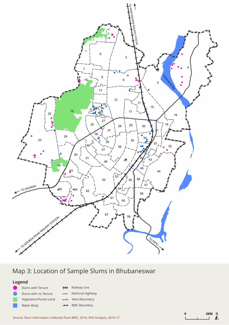
tenure, land ownership, age of settlement, housing and services (Map 3; Table 2).
1Notified Slums: All notified areas in a town or city notified as ‘Slum’ by State, UT Administration or Local
Government under any Act including a ‘Slum Act’; Recognised Slums: All areas recognised as ‘Slum’ by State,
UT Administration or Local Government, Housing and Slum Boards, which may have not been formally
notified as slum under any act; Identified Slum: A compact area of at least 300 population or about 60-70
households of poorly built congested tenements, in unhygienic environment usually with inadequate
infrastructure and lacking in proper sanitary and drinking water facilities (Source: Census of India, 2013).
In case of Bhubaneswar, Authorised Slums are erstwhile villages which are presently within BMC
boundaries and retain their land rights. Unauthorised slums are slums on either central or state
government land and do not possess any rights on the land on which they are currently living (Source:
Interviews with municipal officials).
Table 1: Slums in Bhubaneswar
Source Number of
Slums
Slum HH Proportion of
Total HH
Slum
Population
Proportion of
Total
Population
BMC (n.d.) 436 80,716 41% 3,01,797 36%
Census of
India (2011)
- 42,277 21% 1,63,983 19%
Census of
India, 2001
- 18,048 9% 71,403 8%
CDP Vision
Plan, 2030
(2010)
193 - -
CDP, 2006 250 - -
4
5
3
15
23
6
9
1
44
12
49
52
18
10
67
64
8
7
62
59
50
2
22
3236
17
40
24
65
58
16
14
11
51
63
35
46
60
3025
31
47
37
28
55
19
41
4839
29
56
34
61
42
33
53
54
27
13
43
38
66
45
57
20
26
21
TO KHURDA
TO KHURDA R
OAD RAILW
AY STA
TION
TO PIPILI
TO
MA
NC
HE
SW
AR
RA
ILWA
Y S
TA
TIO
N
KU
AKH
AI R
IVER
Railway Line
National Highway
Ward Boundary
BMC Boundary
Recognised Slum
Vegetation/Forest Land
Water Body
Legend
Map 2: Location of Recognised Slums in Bhubaneswar
Source: Slum information collected from BMC, 2016; IIHS Analysis, 2016-17.
N0 2KM
Railway Line
National Highway
Ward Boundary
BMC Boundary
Slums with Tenure
Vegetation/Forest Land
Water Body
Legend
Map 3: Location of Sample Slums in Bhubaneswar
Source: Slum information collected from BMC, 2016; IIHS Analysis, 2016-17.
N0 2KM
Slums with no Tenure

12
The following sections gives an overview of characteristics of sample authorised and
unauthorised slums based on self-reporting. Over sampling of authorised slums was
done to understand the exact form and nature of tenurial rights.
5.2. Characteristics of Unauthorised Slums
TENURE
Majority of the unauthorised slums are located on state government land and some are
on central government land (Railways, Defence). As a result, none of the settlements
have any occupancy documents or tenurial rights over the land and house.
HOUSING
In the case of older settlements, it was found that majority of the houses were pucca as
they had time to consolidate and improve their living conditions over the years. Newer
settlements had a higher degree of kutcha houses. Houses abutting the roads/highways
were also mostly kutcha in nature, this could be because of their proneness to eviction
owing to their visibility.
SERVICES
Majority of the unauthorised slum settlements had either BMC or PHED boring for
water supply from which residents would extend and make their individual connections
to their homes. As majority of the unauthorised slums were within the city and faced
space constraints, very few households had been able to construct private toilets.
5.3. Characteristics of Authorised Slums
TENURE
There are diverse tenurial arrangements within the broad category of authorised slums.
During fieldwork, it was discovered that namely three categories of settlements are
counted within authorised slums:
a. Government rehabilitation sites: There are three clusters of government
rehabilitation sites made in the 1980s. Residents were resettled from the city to
these sites which at that time were extremely far away from the city. Households
Table 2: Tenurial Details of Sample Slums
Type of Slum Total Sample Percentage
Unauthorised Slums (No Tenurial rights) 320 40 12.5%
Authorised Slums (Some Form of Tenurial Rights) 116 48 41.4%
Total 436 88 20.2%
Source: Discussions with Municipal officials, 2016; IIHS Primary Survey, 2016.

13
living in these sites were given plot sizes of approximately 600 sq.ft. along with some
financial assistance in terms of a loan or grant. These sites were given to the
households with a 90-year lease agreement.
b. BSUP housing sites: BSUP housing projects constructed in early 2000s are also
counted within authorised slums. These individual houses on single plots also have
a 90-year lease agreement.
c. Urban villages: Villages that are now within BMC boundary are also counted within
authorised slums. Residents own the land as well as the houses.
HOUSING
Not more than a handful of houses were kutcha in any slum. While tenure has a role to
play in housing quality, the permanency of the structures could be seen also because of
the fact that most of the settlements were old and consolidated. BSUP project sites &
the old government resettlement sites had mostly single storeyed houses on individual
plots, with the exception of few kutcha houses right towards the edge of the road. Some
of the urban villages towards the outer edge of the city even had G+1 and G+2 housing.
SERVICES
Residents get water from either BMC/PHED boring connections, public stand-posts or
have their own wells. Only the BSUP housing sites have piped water supply for each
house. Some residents also purchase water from elsewhere to supplement their
requirements.
Table 3: Tenurial Details of Sample Authorised Slums
Type of Authorised Slum Sample Percentage
BSUP Project Sites with 90- Year Lease Patta 11 23%
Government Resettlement Sites with 90- Year Lease Patta 11 23%
Urban Villages within BMC (own land) 26 54%
Total 48 100%
N= 88. Source: As reported by residents during IIHS Primary Survey, 2016

14
6. Master Plan, Slums and Violations
Land Use Zoning and Development Control Regulations (DCRs) are the two instruments
in Master Plan that guide the urban growth and development. While land use zoning at
the city level indicate the broad land use zones, DCRs give details of uses/ activities
permitted under each of the broad land use zone category. For example, Residential
Use Zone (R) is a broad category under which permitted activities include plotted
housing, group housing, night shelters, convenience shopping, high school, community
hall, etc. While uses/ activities like cinema halls, colleges, etc. could be permitted on the
basis of an application to the competent authority, uses/ activities like slaughter houses,
heavy industries, stadiums, etc. are prohibited in the residential use zone. Similarly,
associated residential uses are permissible in the other use zones like Commercial
(C1&C2) and Public Semi-Public (PS), given permission based on the application. The
uses and activities permitted/ permissible on application/ prohibited under each of the
land use zones are listed in Annex 2.
Please note that the following analysis is done on the layer of broad land use zones, as
earmarked in the Master Plan.
6.1. Understanding Land Use Violations: Overlay Analysis
a. Existing Land Use, 2010
Overlay analysis of the identified slums on Existing Land Use (2010) shows that almost
20 per cent of the slums are on the land marked entirely as residential. Majority of the
slums (65 per cent) are on lands partly marked as residential and partly non-residential
in the existing land use map. Almost 15 per cent of the slum settlements are marked as
entirely non-residential in the existing land use map (Table 4).
Table 4: Overlay Analysis of Existing Land Use and Recognised Slums
S. No Land Use Category No. of Slums Percentage
1. Residential-Urban 44 10.1%
2. Residential-Other 42 9.6%
3. Partly Residential-Urban & Other Uses 137 31.4%
4. Partly Residential-Other & Other Uses 112 25.7%
5. Partly Residential-Urban, Residential-Other & Other Uses 37 8.5%
6. Transportation 11 2.5%
7. Industrial 8 1.8%
8. Public Semi-Public 4 0.9%
9. Vegetation/Forest 2 0.5%
10. Agricultural 1 0.2%
11. Commercial 1 0.2%
12. Recreational 1 0.2%
13. Mix of two or more non-residential uses 36 8.3%

15
Table 4: Overlay Analysis of Existing Land Use and Recognised Slums
S. No Land Use Category No. of Slums Percentage
Total 436 100.00%
Source: IIHS Analysis, 2016-17.
The cross tabulation of existing land use with tenurial rights clearly shows the linkage
between the two (Table 5). Almost 96 per cent of the authorised slums are on lands
marked as residential fully or partially in the existing land use map. On the other hand,
the proportion drops to 80 per cent in the case of unauthorised slums.
Table 5: Existing Land Use vs. Tenurial Rights
S. No Existing Land Use Authorised
Slums
Unauthorised
Slums
Total
1. Residential-Urban 7 37 44
2. Residential-Other 14 28 42
3. Partly Residential-Urban & Other Uses 17 120 137
4. Partly Residential-Other & Other Uses 66 46 112
5. Partly Residential-Urban, Residential-Other
& Other Uses
7 30 37
6. Transportation 11 11
7. Industrial 8 8
8. Public Semi-Public 4 4
9. Vegetation/Forest 2 2
10. Agriculture 1 1
11. Commercial 1 1
12. Recreational 1 1
13. Mix of two or more non-residential uses 5 31 36
Typology Total 116 320 436
Source: IIHS Analysis, 2016-17.
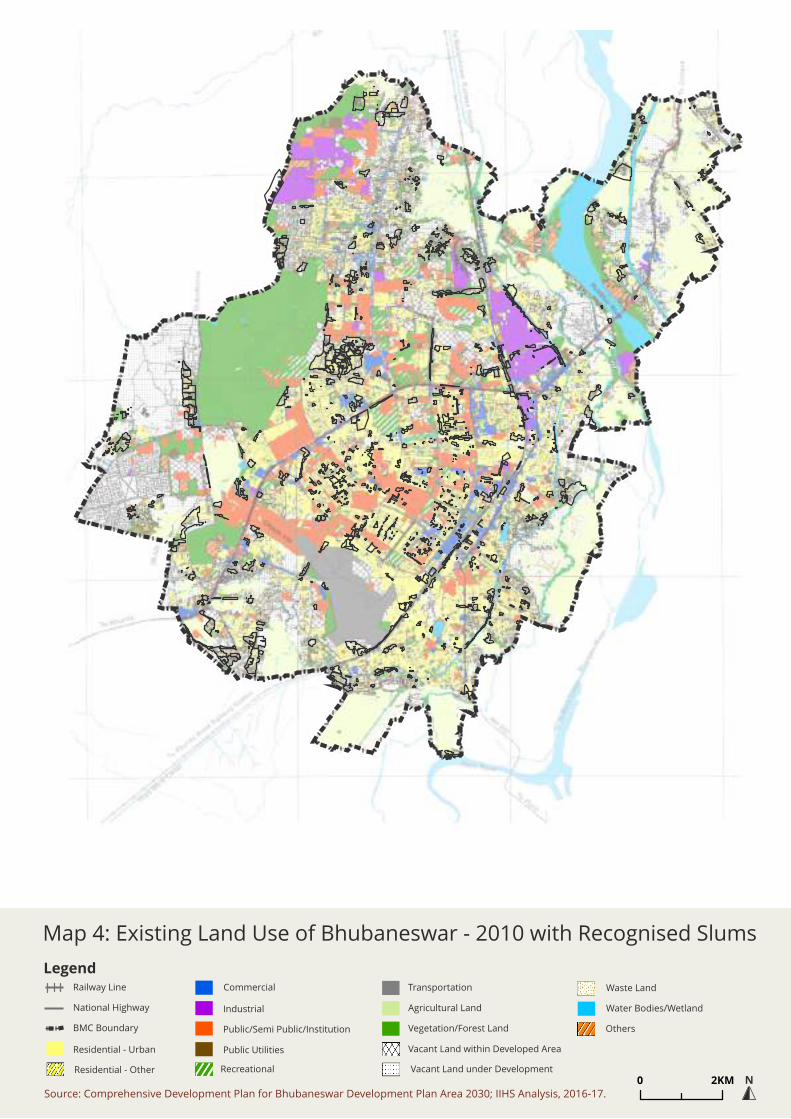
Legend
Map 4: Existing Land Use of Bhubaneswar - 2010 with Recognised Slums
Source: Comprehensive Development Plan for Bhubaneswar Development Plan Area 2030; IIHS Analysis, 2016-17.
N0 2KM
Commercial
Industrial
Public/Semi Public/Institution
Public Utilities
Transportation
Agricultural Land
Vegetation/Forest Land
Vacant Land within Developed Area
Vacant Land under Development
Waste Land
Others
Water Bodies/Wetland
Residential - Urban
Railway Line
National Highway
BMC Boundary
Residential - Other Recreational

16
b. Proposed Land Use, 2030
Overlay analysis of identified slums on Proposed Land Use (Vision 2030) shows almost
28 per cent of slums fall entirely on lands earmarked for residential use. Another 36 per
cent slums are on lands partially proposed as residential and partially other uses. As
high as 36 per cent of slums are on lands entirely earmarked for non-residential uses;
predominant uses being transportation and public semi-public, or a mix of both.
Table 6: Overlay Analysis of Proposed Land Use and Recognised Slums
S. No Land Use Category No. of Slums Percentage
1 Residential 121 27.8%
2 Residence within Special Heritage Zone & other use 13 3.0%
3 Partly Residential & Other Uses 142 32.6%
4 Transportation 38 8.7%
5 Public Semi-Public 33 7.6%
6 Commercial 13 3.0%
7 Water Bodies 4 0.9%
8 Industrial 3 0.7%
9 Agricultural 1 0.2%
10 Environmentally Sensitive Zone 1 0.2%
11 Mix of Two or More Non-Residential Uses 67 15.4%
Total 436 100.0%
Source: IIHS Analysis, 2016-17.
The tension between the land use and tenurial status of ‘slums’ becomes even more
clearer in the proposed land use. Similar to existing land use, almost 93 per cent of
authorised slums make their way to residential use (fully or partially) in the Master Plan
– 2030. On the other hand, only 52.5 per cent of the unauthorised slums find their way
in the residential use (fully or partially) in the Master Plan – 2030.
Table 7: Proposed Land Use vs. Tenurial Rights
S. No Proposed Land Use Authorised Slums Unauthorised
Slums
Total
1. Residential 52 69 121
2. Residence within Special Heritage
Zone & other use
7 6 13
3. Partly Residential & Other Uses 49 93 142
4. Transportation 4 34 38
5. Public & Semi-Public 33 33
6. Commercial 13 13
7. Water Bodies 4 4
8. Industrial 3 3
9. Agricultural 1 1

17
Table 7: Proposed Land Use vs. Tenurial Rights
S. No Proposed Land Use Authorised Slums Unauthorised
Slums
Total
10. Environmentally Sensitive Zone 1 1
11. Mix of Two or More Non-
Residential Uses
3 64 67
Typology Total 116 320 436
Source: IIHS Analysis, 2016-17.
6.2. Master Plan and Housing for the Urban Poor
With the aim of eliminating housing shortage by 2030, the future demand for housing in
the BDPA has been calculated as 4.3 Lakh dwelling units, keeping in mind 10 per cent of
the authorised slum households and 80 per cent of the unauthorised slum households
as households occupying non-standard dwelling units to compute the qualitative
housing shortage. Almost 37 per cent of this housing stock is proposed for LIG and EWS
households.
The Master Plan estimated a total of 193 slums in Bhubaneswar, 59 authorised and 131
unauthorised. The growth rate of slums in Bhubaneswar is estimated to be much higher
than the national and state average. The Master Plan put forward a range of
approaches/ strategies to address the issue of slums including: inclusive approach to
definition of slum/ informal settlement and comprehensive listing; registration of slum
dwellers and identity cards; de-listing of settlements after they reach the acceptable
levels; granting of tenure; environmental improvement; resettlement; economic
development; etc.
Odisha also has a slum rehabilitation and development policy (SRDP, 2011) and has
recently formulated its affordable housing policy. The SRDP aims to have a slum free
Odisha by 2020 and improve conditions of urban poverty by upgrading through in-situ
development, all tenable settlements, as far as possible, through provision of tenure
security, and minimising far-site relocation. The policy mentions the incremental
provision of tenure and basic services through mainstreaming of slums and maintaining
a supply of formal & affordable rental housing options. In order to prevent future
slums, SRDP 2011 recommends all new housing projects developed by public or private
agencies, to mandatorily construct 20-25 per cent housing for LIG/EWS groups as well as
have reservations in plotted development. SRDP also prescribes financial inclusion,
denotification of upgraded slum settlements, rental housing options and community
participation in the decision-making process.
The Affordable Housing Policy for Odisha calls for reservation of land at the city and
zonal level for housing the urban poor. Since Master Plan was prepared before these
policies, the integration is yet to be made.

Legend
Map 5: Proposed Land Use of Bhubaneswar - 2030 with Recognised Slums
Source: Comprehensive Development Plan for Bhubaneswar Development Plan Area 2030; IIHS Analysis, 2016-17.
N0 2KM
Railway Line
National Highway
BMC Boundary
MRTS
Retail Commercial & Business
Use Zone
Residential Use ZoneR
C-1
Airport
Bus Depots/Truck Terminals
Railways
Forest
Rivers, Canals & Streams
Agricultural
Ponds, Lakes & Lagoons
Protected Monuments & Precincts
Residential within Special Heritage Zone
Public & Semi-Public within Special Heritage Zone
Environmentally Sensitive Zone
Commercial within Special Heritage Zone
Public & Semi-Public Use Zone
Open Space Use Zone
Utility & Services Use Zone
Road
Wholesale Commercial Use Zone
Industrial Use Zone
C-2
I
PS
US
OS
T-1
T-2
T-3
T-4
A-1
A-2
W-1
W-2
SH
SH-R
SH-C
SH-PS
ES

20
7. Conclusion
The detailed study of violations, disaggregated by tenurial rights and relationship to
land use zones in the existing and notified Land Use Plans, suggests several important
insights that must be investigated further as an extension of this study or through more
studies.
The characterization and use of the word “slum” flattens diverse land and property
regimes, and neighbourhoods. This is particularly true in transitioning, mid-size urban
centres like Bhubaneswar where expansion of municipal boundary would bring
erstwhile villages in urban limits, and applying “slum” definition to these villages in the
same way as it is applied in bigger cities (to ensure recognition and therefore,
protection) could possibly have opposite effect. It would mean that the “slums” with
tenure and without tenure could potentially be approached in a similar fashion under a
“slum” improvement programme. It is important to have the two layers of tenurial rights
and physical environment as separate. Even from a physical environment point of view
alone, it may not be ideal to call erstwhile villages as “slums” as soon as they enter the
urban limits, especially when the entire city lacks basic infrastructure and services.
In this study, we note that there is a mix of authorised and unauthorised slums in
Bhubaneswar. The settlements that qualify for “authorised” slums range from villages
that got included into urban limits over the years to government built resettlement
sites; “unauthorised” slums, on the other hand, comprise settlements that do not have
tenurial rights. These settlements have rightful claim over their land, dwelling units and
for the most part are not in violation of Land Use. Their being counted as “slums” along
with unauthorised slums counters a simplistic reduction of settlements with varied
histories to the “slum” that signals not just inadequacy of services but also violation of
planning and law. Categorising government built resettlement sites as “slums” would
just mean that their own settlements can’t qualify to be non-slum, in which case how
can they be expected to run any slum improvement programme in an effective manner.
However, unlike Ranchi, a significant part of the ‘slums’ in Bhubaneswar are
unauthorised with no tenurial rights. This is critical because it alters the kind of policy
interventions that are possible in settlements that lack infrastructure and services but
do possess strong claims of varying kinds to tenure, and in settlements that do not
possess any claims to the land/ property.
Here, the overlay analysis is important. Even if residents in these ‘slums’ have tenurial
rights, if they are against land use zoning, they would still be in a different mode of
violation of the Plan. Our analysis, however, shows that most authorised slums are
within residential use whether one goes by Existing Land Use or the Proposed Land Use
for 2037. Bhubaneswar clearly has what one of the authors here as called an “upgrading
dividend” (Bhan 2013). At this juncture, settlements that require infrastructure and
services are both at good locations within the city (where employment and

21
transportation are viable) and they have strong tenurial rights that makes upgradation
politically feasible. This is precisely the possibility that a mid-size city before its big
urban transition could take. How should the Master Plan for 2037 use its zoning
categories and land allocations to protect and upgrade these settlements rather than
inadvertently turn them into violations? As new zones change around settlements, the
risk is that a planning process not sensitive to existing “slums” will turn them into
violations despite their long existence. Here, it will be planning that regulates and
creates illegality rather than the other way around (Bhan 2013).
For settlements that lack tenurial rights but are on government land, the recognition
that they do not violate zoning categories also provides the possibility of arguing for in-
situ forms of development and expansion of tenure. After all, the nature of the
“violation” is simplified – residential land is being used for its intended purpose and is
publicly owned. Here, upgradation and tenure expansion would not require a change of
land use, and municipal acts, in particular, give the state authority to grant more
expansive tenure. Such a move would be much more complicated and, indeed, very
difficult politically for almost half the unauthorised slums in Bhubaneswar, where
‘slums’ had violated land use zones in addition to not having legal claims to the property
they are built on. Again, a closer look at the nature of violations suggests certain
pragmatic, feasible and possible political moves that are otherwise not evident.
There is a need to demand for second tier of Plans, be it zonal plans or town planning
schemes or in some cases, even layout plans. The second tier plans not only make the
Master Plan provisions clearer and detailed out, but are also easier to comprehend by
the local people. This would also give an opportunity to the people to participate in the
plan making.
Assessing the nature of violations, and deepening the size of our sample as work
continues, will allow us to create a complete typology of Bhubaneswar’s recognized
slums. Such data is a powerful tool in engaging with the municipality and urban
planning authorities to argue about nuanced, contextual and particular solutions to
addressing the tenurial and infrastructural needs of ‘slums.’ Breaking the sense that
‘slums’ are simply “violations” that can be dispensed with, such analysis instead argues
that different grades and nature of violations can represent opportunities for
incremental solutions to be tried that are both effective and politically feasible.

22
References
Bhan, G. (2013). Planned illegalities. Economic and Political Weekly, 48(24), 59-70.
Caldeira, T. 2014. ‘Peripheral Urbanisation’. Paper presented at the LSE Cities Public Lectures,
London, 23 October.
Census of India 2011a. Houselisting and Housing Census Data. In: Office of the Registrar General
& Census Commissioner (ed.). New Delhi: Government of India.
Census of India. 2013. Primary Census Abstract for Slum. Office of the Registrar General &
Census Commissioner, India. http://www.censusindia.gov.in/2011-Documents/Slum-26-09-
13.pdf.
Housing & Urban Development Department. 2010. Comprehensive Development Plan for
Bhubaneswar Development Plan Area 2030. Government of Odisha.
MoHUPA. 2011. Rajiv Awas Yojana - Guidelines. Government of India.
http://mhupa.gov.in/writereaddata/02-RAY-Guidelines.pdf.
MoUD. 2016. Smart City Proposal. Government of India.
Housing & Urban Development Department. 2011. Slum Rehabilitation & Development Policy.
Government of Odisha.

Annex 1: Case Studies
23


24
Salia Sahi
Ward No.:
16 & 20
No. of Households:
Approx. 8,000
Known as ‘Mini Odisha’ in Bhubaneswar, Salia Sahi constitutes
the biggest slum in the city. Made up of several sub-settlements
and colonies, Salia Sahi spreads across wards 16 & 20 and
occupies prime location. The settlement is listed as an
unauthorised settlement as it is on government land. Residents
do not possess any documents for the land on which they
reside nor have they been given any tenurial rights. As the
settlement is quite old, majority of the houses are pakka with
very few houses in between that are Kutcha. All houses have
electricity. Not all houses towards the outer fringe of the basti
have individual toilets for their homes, but almost all houses
within the basti have toilets. Households get water from the
BMC boring connections constructed at certain spots. There is
no form of any drainage present in the basti, as a result the
inner roads of the basti are littered with solid waste.
Most of the male residents work as auto-drivers, daily wage
labourers or run/own petty shops within the basti.
Google Earth Imagery 2010 Google Earth Imagery 2016
Existing Land Use,2010: Residential Other Proposed Land Use, 2030: Public & Semi-Public
Use
Source:
Name of Slums and boundaries collected from Bhubaneshwar Municipal Corporation, 2016
Existing & Proposed Land Use Maps: Comprehensive Development Plan for Bhubaneswar Development Plan
Area 2030
Photographs: IIHS primary survey 2016
25
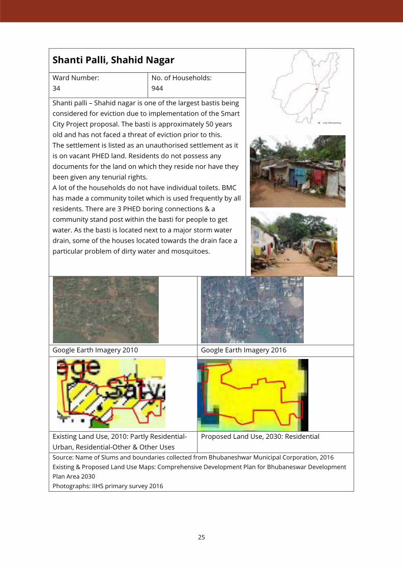
Shanti Palli, Shahid Nagar
Ward Number:
34
No. of Households:
944
Shanti palli – Shahid nagar is one of the largest bastis being
considered for eviction due to implementation of the Smart
City Project proposal. The basti is approximately 50 years
old and has not faced a threat of eviction prior to this.
The settlement is listed as an unauthorised settlement as it
is on vacant PHED land. Residents do not possess any
documents for the land on which they reside nor have they
been given any tenurial rights.
A lot of the households do not have individual toilets. BMC
has made a community toilet which is used frequently by all
residents. There are 3 PHED boring connections & a
community stand post within the basti for people to get
water. As the basti is located next to a major storm water
drain, some of the houses located towards the drain face a
particular problem of dirty water and mosquitoes.
Google Earth Imagery 2010 Google Earth Imagery 2016
Existing Land Use, 2010: Partly Residential-
Urban, Residential-Other & Other Uses
Proposed Land Use, 2030: Residential
Source: Name of Slums and boundaries collected from Bhubaneshwar Municipal Corporation, 2016
Existing & Proposed Land Use Maps: Comprehensive Development Plan for Bhubaneswar Development
Plan Area 2030
Photographs: IIHS primary survey 2016
26
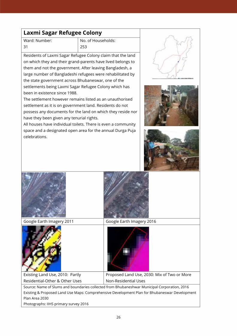
Laxmi Sagar Refugee Colony
Ward: Number:
31
No. of Households:
253
Residents of Laxmi Sagar Refugee Colony claim that the land
on which they and their grand-parents have lived belongs to
them and not the government. After leaving Bangladesh, a
large number of Bangladeshi refugees were rehabilitated by
the state government across Bhubaneswar, one of the
settlements being Laxmi Sagar Refugee Colony which has
been in existence since 1988.
The settlement however remains listed as an unauthorised
settlement as it is on government land. Residents do not
possess any documents for the land on which they reside nor
have they been given any tenurial rights.
All houses have individual toilets. There is even a community
space and a designated open area for the annual Durga Puja
celebrations.
Google Earth Imagery 2011 Google Earth Imagery 2016
Existing Land Use, 2010: Partly
Residential-Other & Other Uses
Proposed Land Use, 2030: Mix of Two or More
Non-Residential Uses
Source: Name of Slums and boundaries collected from Bhubaneshwar Municipal Corporation, 2016
Existing & Proposed Land Use Maps: Comprehensive Development Plan for Bhubaneswar Development
Plan Area 2030
Photographs: IIHS primary survey 2016

27
Shikharachandi Cluster
Ward Number:
2
No. of Households:
837
Spread across 3 clusters, namely Shikharachandi Cluster I,
Cluster II & Cluster III, Shikharachandi is an old resettlement
site. The settlement is about 30 years old and as a result
almost all houses here are pakka, some of them even being
G+2 constructions. At the time of resettlements, households
were given a 600 sq. ft. plot (20 x 30) but did not receive any
financial assistance or compensation to construct housing.
They have at times received arbitrary amounts of Rs. 5,000/-
during monsoons for a few years but even that is not fixed.
The entire Shikharachandi cluster is listed as an authorised
slum. Residents have tenurial rights in the form of a 90-year
leasehold with restriction on sale. Residents have difficulty
getting water as they do not have individual water
connections nor are there any public stand-posts, as a result
they often have to buy their water. Most of the houses do
have their individual toilets. There are some open storm
water drains along the pukka entrance road of the basti.
Most of the male residents work in nearby shops or have
their own petty shops within the basti.
Google Earth Imagery 2011 Google Earth Imagery 2016
Existing Land Use, 2010: Partly Residential-
Urban & Other Uses
Proposed Land Use, 2030: Residential
Source: Name of Slums and boundaries collected from Bhubaneshwar Municipal Corporation, 2016
Existing & Proposed Land Use Maps: Comprehensive Development Plan for Bhubaneswar Development Plan Area 2030
Photographs: IIHS primary survey 2016

28
Niladri Vihar
Ward Number:
14
No. of Households:
Approx. 952
Niladri Vihar is the name of the larger area within which there
are several old resettlement colonies such as Rickshaw Colony,
Panda Park, Hari-Krishna Basti, OMFED Basti etc. which were
resettled in the year 1998. All bastis in Niladri Vihar are listed
as authorised slums. Residents have tenurial rights in the form
of a 90-year leasehold with restriction on sale. Most of
households were given a 25x15 sq. ft. and Rs. 10,000/- to build
housing. An additional amount of Rs. 40,000/- was available for
loan against their patta. Therefore, some HH unable to pay
back BMC the loan had to give up their patta. to the BMC. As a
result, some of the houses have been sold illegally and there
are also some kutcha houses present. Residents earlier got
water from a nearby BMC boring connection and public stand-
posts. PHED has recently given individual connections for most
of the pakka houses but not all. Most of the houses have
individual toilets but not all. Most of the male members of the
basti work as auto-drivers or other daily wage labourers. Next
to Niladri Vihar is also a transit housing site of 1000 units.
These are being made to house families being evicted from the
24 bastis under the smart city project. Each household will be
allotted a single room with no kitchen. There is a community
toilet and a common open area for bathing and washing.
Google Earth Imagery 2011 Google Earth Imagery 2016
Existing Land Use, 2010: Partly Residential-
Other & Other Uses
Proposed Land Use, 2030: Partly Residential &
Other Uses
Source: Name of Slums and boundaries collected from Bhubaneshwar Municipal Corporation, 2016
Existing & Proposed Land Use Maps: Comprehensive Development Plan for Bhubaneswar Development Plan Area
2030
Photographs: IIHS primary survey 2016

29
Dumdum Bharatpur
Ward Number:
63 & 64
No. of Households:
159
Spread across 3 clusters, namely Dumuduma Bhoi Sahi-A,
Dumuduma Pana Sahi and Dumduma Bhoi Sahi, Dumduma is
an old resettlement site within Bharatpur. The settlement is
about 30 years old and as a result almost all houses here are
pakka. There are very few kutcha houses that have come up
towards the entrance of the basti and right next to the road.
At the time of resettlements, 164 households that were
resettled here were given a 600 sq. ft. plot (20 x 30) along with
financial assistance of Rs. 1,50,000/- to construct their houses.
The entire Dumduma cluster is listed as an authorised slum.
Residents have tenurial rights in the form of a 90-year
leasehold with restriction on sale. All households have
individual water connections from PHED and have individual
toilets, baring the exception of very few that don’t. There are
some open storm water drains along the pukka entrance road
of the basti. Most of the male residents work as auto drivers,
daily wage labourers and rickshaw pullers.
Google Earth Imagery 2010 Google Earth Imagery 2016
Existing Land Use 2010: Partly Residential-Other
& Other Uses
Proposed Land Use, 2030: Residential
Source: Name of Slums and boundaries collected from Bhubaneshwar Municipal Corporation, 2016
Existing & Proposed Land Use Maps: Comprehensive Development Plan for Bhubaneswar Development Plan Area
2030
Photographs: IIHS primary survey 2016

30
Haridaspur Cluster
Ward Number:
4
No. of Households:
245
Located in the northern part of the city, Haridaspur is an urban
village included within BMC boundaries. A set of clusters
namely, Haridaspur Akka Biram Sahi, Haridaspur Bandha Sahi,
Haridaspur Majhi Sahi, Haridaspur Mallick Sahi and Haridaspur
Muslim Sahi are the subsets of the larger village.
The village is listed as an authorised slum. As residents have
inherited their land and houses from their respective families,
each of them have the required ownership documents for their
land and as well as their house.
All houses are pakka, some of them are G+1 as well. Only a
handful of houses adjacent to the road do not own their land
and do not have papers for their house as well.
Residents get water from a PHED boring connection nearby.
Not all houses have electricity or individual toilets.
Google Earth Imagery 2011 Google Earth Imagery 2016
Existing Land Use, 2010: Partly Residential-Other
& Other Uses
Proposed Land Use, 2030: Partly Residential &
Other Uses
Source: Name of Slums and boundaries collected from Bhubaneshwar Municipal Corporation, 2016
Existing & Proposed Land Use Maps: Comprehensive Development Plan for Bhubaneswar Development Plan Area
2030
Photographs: IIHS primary survey 2016
31
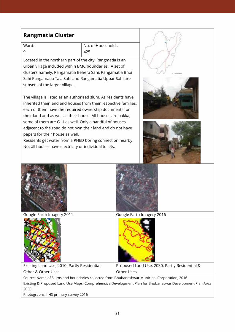
Rangmatia Cluster
Ward:
9
No. of Households:
425
Located in the northern part of the city, Rangmatia is an
urban village included within BMC boundaries. A set of
clusters namely, Rangamatia Behera Sahi, Rangamatia Bhoi
Sahi Rangamatia Tala Sahi and Rangamatia Uppar Sahi are
subsets of the larger village.
The village is listed as an authorised slum. As residents have
inherited their land and houses from their respective families,
each of them have the required ownership documents for
their land and as well as their house. All houses are pakka,
some of them are G+1 as well. Only a handful of houses
adjacent to the road do not own their land and do not have
papers for their house as well.
Residents get water from a PHED boring connection nearby.
Not all houses have electricity or individual toilets.
Google Earth Imagery 2011 Google Earth Imagery 2016
Existing Land Use, 2010: Partly Residential-
Other & Other Uses
Proposed Land Use, 2030: Partly Residential &
Other Uses
Source: Name of Slums and boundaries collected from Bhubaneshwar Municipal Corporation, 2016
Existing & Proposed Land Use Maps: Comprehensive Development Plan for Bhubaneswar Development Plan Area
2030
Photographs: IIHS primary survey 2016

32
Ghatikia Cluster
Ward Number:
23
No. of Households:
257
Ghatikia is an urban village included within BMC boundaries. A
set of clusters namely, Ghatikia Baramana Sahi, Ghatikia Bhoi
Sahi, Ghatikia Gada Sahi, Ghatikia Tala Gada Sahi and Ghatikia
Uppar Sahiare subsets of the larger village. Some parts of the
village were destroyed in the cyclone of 1999 and the villagers
were given some land as compensation.
The village is listed as an authorised slum. As residents have
inherited their land and houses from their respective families,
each of them have the required ownership documents for
their land and as well as their house. All houses are pakka with
only a handful of houses adjacent to the road do not own their
land and do not have papers for their house.
Residents get water from a PHED boring connection nearby
and some have their private wells. All houses have electricity
and individual toilets.
Google Earth Imagery 2011 Google Earth Imagery 2016
Existing Land Use, 2010: Partly Residential-
Other & Other Uses
Proposed Land Use, 2030: Residential,
Transportation
Source: Name of Slums and boundaries collected from Bhubaneshwar Municipal Corporation, 2016
Existing & Proposed Land Use Maps: Comprehensive Development Plan for Bhubaneswar Development Plan
Area 2030
Photographs: IIHS primary survey 2016

33
Jokalandi Cluster
Ward Number:
22
No. of Households:
3,039
Located towards the western edge of the city, Jokalandi is a
BSUP project site, listed as an authorised slum by BMC. The
entire settlement is divided into 12 clusters, with the latter
additions being more recent.
There are some stretches within Jokalandi, especially towards
the road in cluster 10 that is not BSUP housing but squatter
settlements on government land that do not have any form of
patta or rights for their houses. All settlements are around 25
years old. Households that do not have a patta get their water
from a government boring connection nearby. They also
received Rs. 5,000/- as a subsidy to build their own toilets. The
BSUP houses have a 90-year leasehold with restriction on sale.
Illegal sale through power of attorney is however rampant.
House have PHED water connections and individual toilets
inside their houses.
Google Earth Imagery 2011 Google Earth Imagery 2016
Existing Land Use, 2010: Partly Residential-Other
& Other Uses
Proposed Land Use, 2030: Residential
Source: Name of Slums and boundaries collected from Bhubaneshwar Municipal Corporation, 2016
Existing & Proposed Land Use Maps: Comprehensive Development Plan for Bhubaneswar Development Plan Area
2030
Photographs: IIHS primary survey 2016

34
Raghunath Nagar, Shastri Nagar, Satya
Nagar & Suka Vihar
Ward Number:
66
No. of Households:
1,449
Located towards the southern edge of the city is a fairly large
BSUP project cluster within which there are several sub-
settlements. Raghunath Nagar, Barabari Raghunath Nagar,
Shastri Nagar, Satya Nagar and Suka Vihar are the bastis in this
area that are listed as authorised slums by BMC.
All the settlements are approximately 35 years old. Residents
were given a 600 sq. ft. plot (20 x 30) with financial assistance of
up to Rs. 1.7 lakh as loan. All houses have individual water
connections and individual toilets. There is much less
reconstruction and illegal sale as compared to some of the other
BSUP project sites. The bastis though similar in most other
aspects, have different time periods for their leasehold.
Raghunath Nagar & Barabari Raghunath Nagar has a 10-year
leasehold with restriction on sale. Suka Vihar has a 30-year
leasehold with restriction on sale. Satya Nagar & Shastri Nagar
have 90-year leasehold with restriction on sale.
Google Earth Imagery 2010 Google Earth Imagery 2016
Existing Land Use, 2010: Partly Residential-
Other & Other Uses
Proposed Land Use, 2030: Residential
Source: Name of Slums and boundaries collected from Bhubaneshwar Municipal Corporation, 2016
Existing & Proposed Land Use Maps: Comprehensive Development Plan for Bhubaneswar Development Plan
Area 2030
Photographs: IIHS primary survey 2016
35
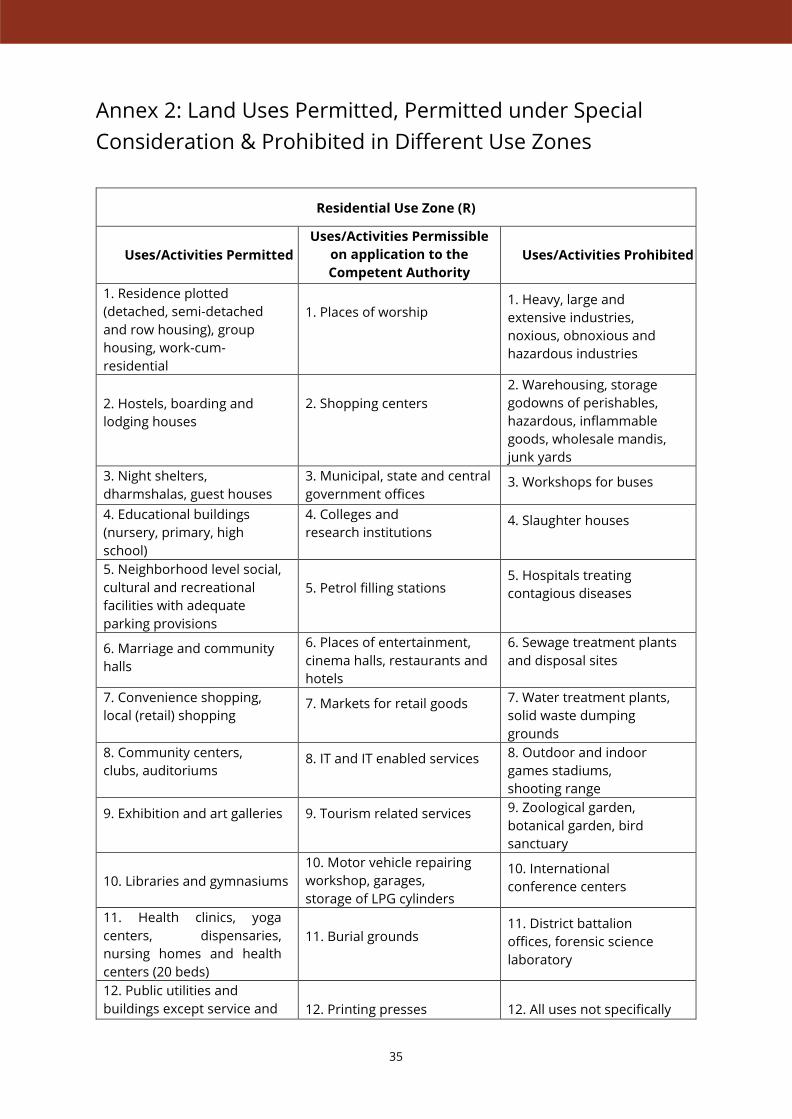
Annex 2: Land Uses Permitted, Permitted under Special
Consideration & Prohibited in Different Use Zones
Residential Use Zone (R)
Uses/Activities Permitted
Uses/Activities Permissible
on application to the
Competent Authority
Uses/Activities Prohibited
1. Residence plotted
(detached, semi-detached
and row housing), group
housing, work-cum-
residential
1. Places of worship 1. Heavy, large and
extensive industries,
noxious, obnoxious and
hazardous industries
2. Hostels, boarding and
lodging houses
2. Shopping centers
2. Warehousing, storage
godowns of perishables,
hazardous, inflammable
goods, wholesale mandis,
junk yards
3. Night shelters,
dharmshalas, guest houses
3. Municipal, state and central
government offices 3. Workshops for buses
4. Educational buildings
(nursery, primary, high
school)
4. Colleges and
research institutions 4. Slaughter houses
5. Neighborhood level social,
cultural and recreational
facilities with adequate
parking provisions
5. Petrol filling stations 5. Hospitals treating
contagious diseases
6. Marriage and community
halls
6. Places of entertainment,
cinema halls, restaurants and
hotels
6. Sewage treatment plants
and disposal sites
7. Convenience shopping,
local (retail) shopping 7. Markets for retail goods 7. Water treatment plants,
solid waste dumping
grounds
8. Community centers,
clubs, auditoriums 8. IT and IT enabled services 8. Outdoor and indoor
games stadiums,
shooting range
9. Exhibition and art galleries 9. Tourism related services 9. Zoological garden,
botanical garden, bird
sanctuary
10. Libraries and gymnasiums
10. Motor vehicle repairing
workshop, garages,
storage of LPG cylinders
10. International
conference centers
11. Health clinics, yoga
centers, dispensaries,
nursing homes and health
centers (20 beds)
11. Burial grounds 11. District battalion
offices, forensic science
laboratory
12. Public utilities and
buildings except service and
12. Printing presses
12. All uses not specifically

36
Residential Use Zone (R)
Uses/Activities Permitted
Uses/Activities Permissible
on application to the
Competent Authority
Uses/Activities Prohibited
storage yards, electrical
distribution depots and
water pumping stations
employing not more than 10
persons
permitted in column (a)
and (b)
13. Nursery and green houses 13. Godowns /warehousing
of non-perishables
14. Services for households
(salon, parlours, bakeries,
sweet shops, dry cleaning,
internet kiosks etc.)
14. Bus depots without
workshop
15. Banks and professional
offices not exceeding one floor
15. Household industries if
the area for such use does
not exceed one floor and
there shall be no public
display of the goods
16. Bus stops, taxi stands,
3-wheeler/auto stands,
rickshaw stands
16. Consulates
17. Police posts and post
offices
18. Parks and tot–lots

37
Retail Commercial and Business Use Zone (C1)
Uses/Activities Permitted
Uses/Activities Permissible
on application to the
Competent Authority
Uses/Activities Prohibited
1. Retail business, mercantile 1. Associated residential uses 1. Polluting industries
2. Commercial centers
2. Wholesale storage yards
2. Heavy, extensive,
noxious, obnoxious,
hazardous and extractive
industrial units
3. Banks, financial services
and stock exchanges
3. Service garages provided
they do not directly abut the
main road
3. Hospitals, research
laboratories treating
contagious diseases
4. Perishable goods markets 4. Printing presses
employing not more than 10
persons
4. Poultry farms, dairy
farms, slaughter houses
5. Business and
professional offices
5. 20 bedded hospitals not
treating contagious diseases
and mental patients
5. Sewage treatment plants
and disposal sites, solid
waste treatment plants and
dumping grounds
6. Private institutional offices
and semi government
offices
6. Weigh bridges
6. Agricultural uses,
storage of perishable and
inflammable commodities
7. Shops and shopping malls 7. Colleges, polytechnics
and higher technical
institutes
7.Quarrying of gravel, sand,
clay and stone
8. Commercial services 8. Sports complex and
stadiums
8. Zoological gardens,
botanical gardens and bird
sanctuary
9. Restaurants and hotels
9. Transient visitor’s homes 9. Sports training centers
10. Hostels, boarding
houses, social and welfare
institutions, guest houses
10. Places of entertainment,
recreational uses and
museums
10. District battalion offices
11. Convenience and
neighborhood shopping
centers, local shopping
centers, weekly and formal
markets, bakeries and
confectionaries
11. Convention centers
11. Forensic science
laboratory and all other
related activities which may
cause nuisance
12. Cinema halls,
theaters, banquet halls,
auditoriums
12. Religious places 12. Court
13. Marriage and community
halls, night shelters
13. Public utilities,
telephone exchanges
13. All uses not specifically
permitted in the column (a)
and (b)
38
Retail Commercial and Business Use Zone (C1)
Uses/Activities Permitted
Uses/Activities Permissible
on application to the
Competent Authority
Uses/Activities Prohibited
14. Clinics and nursing homes 14. Police posts and post
offices
15. Petrol Pumps 15. Residential
16. IT and IT enabled services 16. Picnic Hut
17. Commercial institutes,
research and training
institutes
18. Parking lots
19. Taxi stands, 3-
wheeler/auto stands,
rickshaw stands
39
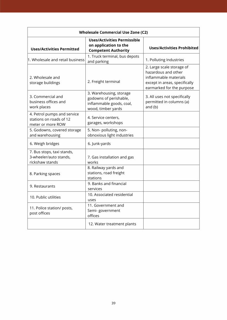
Wholesale Commercial Use Zone (C2)
Uses/Activities Permitted
Uses/Activities Permissible
on application to the
Competent Authority
Uses/Activities Prohibited
1. Wholesale and retail business 1. Truck terminal, bus depots
and parking 1. Polluting Industries
2. Wholesale and
storage buildings
2. Freight terminal
2. Large scale storage of
hazardous and other
inflammable materials
except in areas, specifically
earmarked for the purpose
3. Commercial and
business offices and
work places
3. Warehousing, storage
godowns of perishable,
inflammable goods, coal,
wood, timber yards
3. All uses not specifically
permitted in columns (a)
and (b)
4. Petrol pumps and service
stations on roads of 12
meter or more ROW
4. Service centers,
garages, workshops
5. Godowns, covered storage
and warehousing
5. Non- polluting, non-
obnoxious light industries
6. Weigh bridges 6. Junk-yards
7. Bus stops, taxi stands,
3-wheeler/auto stands,
rickshaw stands
7. Gas installation and gas
works
8. Parking spaces
8. Railway yards and
stations, road freight
stations
9. Restaurants 9. Banks and financial
services
10. Public utilities 10. Associated residential
uses
11. Police station/ posts,
post offices
11. Government and
Semi- government
offices
12. Water treatment plants

40
Industrial Use Zone (I)
Uses/Activities Permitted
Uses/Activities Permissible
on application to the
Competent Authority
Uses/Activities Prohibited
1. All kind of
nonpolluting industries
1. Heavy, extensive and
other obnoxious, hazardous
industries subject to the
approval of the Orissa
Pollution Control Board
1. General business unless
incidental to and on the
same site with industry
2. IT & ITES 2. Industrial Research Institute 2. Schools and colleges
3. SEZs notified by
government of India
3. Technical
Educational
Institutions
3. Hotels, motels and
caravan parks
4. Loading, unloading spaces 4. Junkyards, sports/
stadiums/ playgrounds 4. Recreational sports or
centers
5. Warehousing, storage and
depots of non-perishable and
non- inflammable
commodities
5. Sewage disposal works,
electric power plants, service
stations
5. Other non-industrial
related activities
6. Cold storage and ice factory 6. Govt. semi-govt.,
private business offices 6. Religious buildings
7. Gas godowns 7. Banks, financial institutions
and other commercial offices 7. Irrigated and sewage farms
8. Wholesale
business
establishments
8. Agro-based industries, dairy
and farming
8. Major oil depot and
LPG refilling plants
9. Petrol filling station with
garages and service stations 9. Gas installations and gas
works
9. Social buildings
10. Bus terminals and bus
depots and workshops 10. Workshops garages 10. All uses not specifically
permitted in columns (a)
and (b)
11. Parking, taxi stands, 3-
wheeler/auto stands,
rickshaw stands
11. Hotels and guest houses
12. Residential buildings for
essential staff and for watch
and ward
12. Museum
13. Public utilities 13. Helipads
14. Hospitals and medical
centers

41
Public & Semi-public Use Zone (PS)
Uses/Activities Permitted
Uses/Activities Permissible
on application to the
Competent Authority
Uses/Activities Prohibited
1. Government offices,
central, state, local and semi-
government, public
undertaking offices
1. Residential flats,
residential plots for group
housing and staff housing
1. Heavy, extensive and
other obnoxious, hazardous
industries
2. Universities and
specialized educational
institutions, colleges,
schools, research and
development centers
2. IT services
2. Slaughterhouses
3. Social and welfare centers 3. Defense quarters 3. Junkyard
4. Libraries 4. Hostels, transit
accommodation
4. Wholesale mandis
5. Hospitals, health
centers, dispensaries
and clinics
5. Entertainment and
recreational complexes
5. Dairy and poultry
farms, farmhouses
6. Social and cultural institutes 6. Nursery and
kindergarten, welfare
center
6. Workshops for servicing
and repairs
7. Religious buildings 7. Open air theater,
playground
7. Processing and sale of
farm products
8. Conference halls 8. Residential club, guest house 8. All uses not specifically
permitted in columns (a)
and (b)
9. Community halls,
Kalyan mandaps,
Dharamshala
9. Bus and Truck
terminals, helipads
10. Museums, art
galleries, exhibition
halls, auditoriums
10. Parking areas, taxi
stands, 3-wheeler/auto
stands, rickshaw stands
11. Police stations, police
lines, jails
12. Local state and central
govt. offices uses for
defense purpose
13. Educational and
research institutions
14. Social and cultural
and religious
institutions
15. Local municipal facilities
16. Uses incidental to govt.
offices and for their use
17. Monuments

42
Utility and Services Use Zone (US)
Uses/Activities Permitted
Uses/Activities Permissible
on application to the
Competent Authority
Uses/Activities Prohibited
1. Post offices, Telegraph
offices, public – utilities and
buildings
1. Service industry
1. Any building or structure
which is not required for
uses related to public utilities
and activities is not
permitted therein.
2. Water Treatment Plant,
Sewage Treatment Plant,
Solid waste Treatment Plant
solid waste dumping grounds
2. Warehouse/storage
godowns
2. Heavy, extensive and
other obnoxious, hazardous
industries
3. Radio transmitter and
wireless stations,
telecommunication centers,
telephone exchange
3. Health center for public
and staff or any other use
incidental to public utilities
and services
3. All uses not specifically
permitted in column (a)
and (b)
4. Water supply installations 4. Information/Payment kiosk
5. Sewage disposal works 5. Incidental/ancillary
residential use
6. Service stations 6. Truck terminals, helipads
7. Cremation grounds
and cemeteries/burial
ground
7. Commercial use center
8. Power plants/
electrical substation
9. Radio and television station
10. Fire stations
43
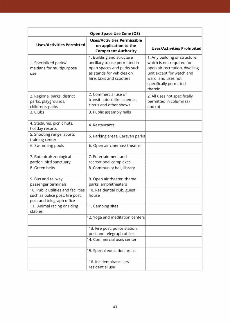
Open Space Use Zone (OS)
Uses/Activities Permitted
Uses/Activities Permissible
on application to the
Competent Authority
Uses/Activities Prohibited
1. Specialized parks/
maidans for multipurpose
use
1. Building and structure
ancillary to use permitted in
open spaces and parks such
as stands for vehicles on
hire, taxis and scooters
1. Any building or structure,
which is not required for
open air recreation, dwelling
unit except for watch and
ward, and uses not
specifically permitted
therein.
2. Regional parks, district
parks, playgrounds,
children’s parks
2. Commercial use of
transit nature like cinemas,
circus and other shows
2. All uses not specifically
permitted in column (a)
and (b)
3. Clubs 3. Public assembly halls
4. Stadiums, picnic huts,
holiday resorts 4. Restaurants
5. Shooting range, sports
training center 5. Parking areas, Caravan parks
6. Swimming pools 6. Open air cinemas/ theatre
7. Botanical/ zoological
garden, bird sanctuary
7. Entertainment and
recreational complexes
8. Green belts 8. Community hall, library
9. Bus and railway
passenger terminals
9. Open air theater, theme
parks, amphitheaters
10. Public utilities and facilities
such as police post, fire post,
post and telegraph office
10. Residential club, guest
house
11. Animal racing or riding
stables
11. Camping sites
12. Yoga and meditation centers
13. Fire post, police station,
post and telegraph office
14. Commercial uses center
15. Special education areas
16. Incidental/ancillary
residential use

44
Transportation Use Zone (T)
Uses/Activities Permitted
Uses/Activities Permissible
on application to the
Competent Authority
Uses/Activities Prohibited
1. All types of roads
1. Way side shops and
restaurants
1. Use/activity not
specifically related to
transport and
communication permitted
herein.
2. Railway stations and yards 2. Authorised/Planned
Vending areas
2. All uses not specifically
permitted in column (a)
and (b)
3. Airport 3. Incidental/ancillary
residential use
4. Bus stops and Bus and
Truck terminals 4. Emergency health care
centre
5. Taxi stands, auto
stands, rickshaw stands 5. Tourism related projects
6. Ferry Ghats
6. All ancillary
(complimentary) uses for
above categories (subject to
decision of the Authority)
7. Parking areas
8. Multi-level car parking
9. Filling stations
10. Transport offices,
booking offices
11. Night shelter, boarding
houses
12. Banks
13. Restaurants
14. Workshops and garages
15. Automobile spares
and services, Godowns
16. Loading and unloading
platforms (with/without
cold storage facility), weigh
bridges
17. Ware houses, Storage
depots
18. Utility networks
(drainage, sewage, power,
tele- communications)
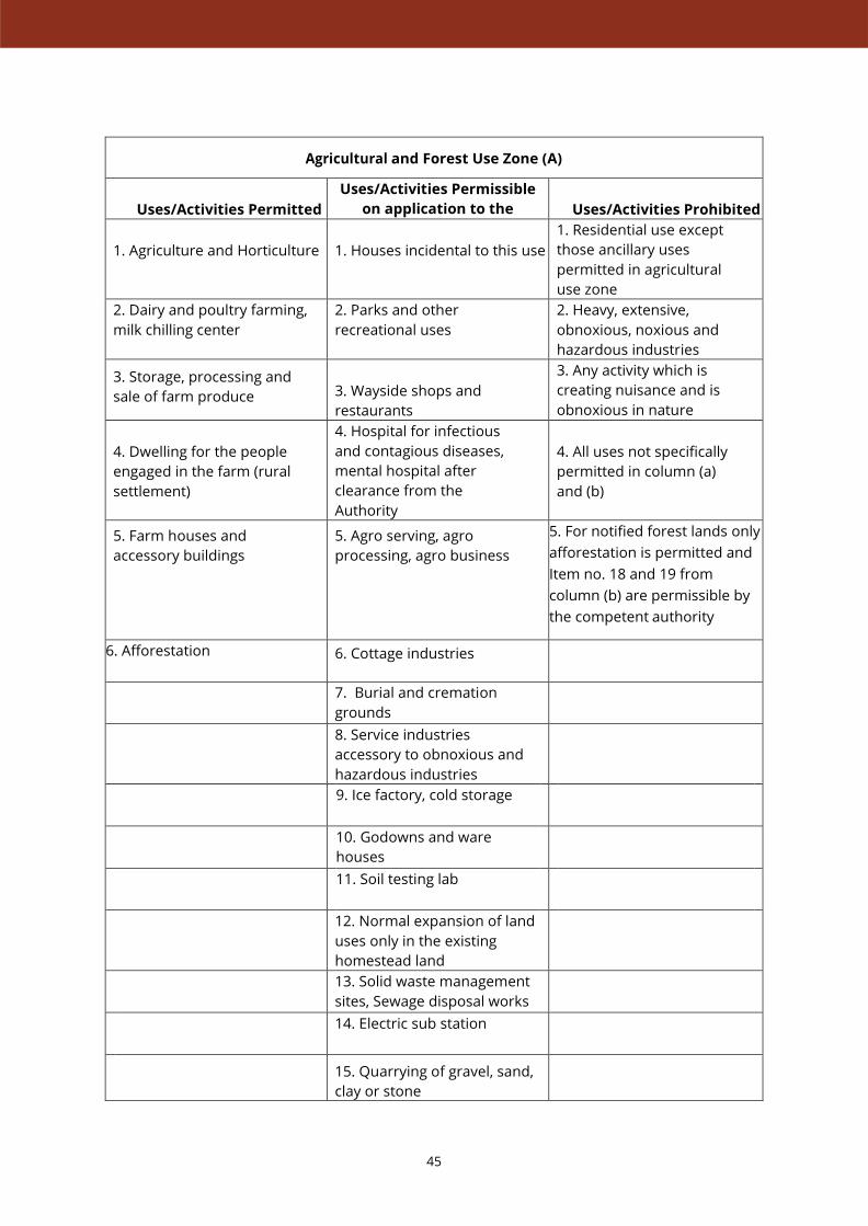
45
Agricultural and Forest Use Zone (A)
Uses/Activities Permitted
Uses/Activities Permissible
on application to the
Competent Authority
Uses/Activities Prohibited
1. Agriculture and Horticulture
1. Houses incidental to this use
1. Residential use except
those ancillary uses
permitted in agricultural
use zone
2. Dairy and poultry farming,
milk chilling center
2. Parks and other
recreational uses
2. Heavy, extensive,
obnoxious, noxious and
hazardous industries
3. Storage, processing and
sale of farm produce
3. Wayside shops and
restaurants
3. Any activity which is
creating nuisance and is
obnoxious in nature
4. Dwelling for the people
engaged in the farm (rural
settlement)
4. Hospital for infectious
and contagious diseases,
mental hospital after
clearance from the
Authority
4. All uses not specifically
permitted in column (a)
and (b)
5. Farm houses and
accessory buildings
5. Agro serving, agro
processing, agro business
5. For notified forest lands only
afforestation is permitted and
Item no. 18 and 19 from
column (b) are permissible by
the competent authority
6. Afforestation 6. Cottage industries
7. Burial and cremation
grounds
8. Service industries
accessory to obnoxious and
hazardous industries
9. Ice factory, cold storage
10. Godowns and ware
houses
11. Soil testing lab
12. Normal expansion of land
uses only in the existing
homestead land
13. Solid waste management
sites, Sewage disposal works
14. Electric sub station
15. Quarrying of gravel, sand,
clay or stone

46
Agricultural and Forest Use Zone (A)
Uses/Activities Permitted
Uses/Activities Permissible
on application to the
Competent Authority
Uses/Activities Prohibited
16. Building construction over
plots covered under town
planning scheme and
conforming uses
17. Brick kilns and extractive
areas
18. Eco-tourism, camping
sites, eco-parks, eco lodges
19. Special outdoor recreations

47
Water Bodies Use Zone (W)
Uses/Activities Permitted
Uses/Activities Permissible
on application to the
Competent Authority
Uses/Activities Prohibited
1. Rivers, canals
1. Fisheries
1. Use/activity not
specifically related to Water
Bodies Use not permitted
herein.
2. Streams, water spring 2. Boating, water theme
parks, water sports,
lagoons
2. All uses not specifically
permitted in column (a)
and (b)
3. Ponds, lakes 3. Water based resort with
special by-laws
4. Wetland, aqua culture pond
4. Any other use/activity
incidental to Water Bodies
Use Zone is permitted.
5. Reservoir
6. Water logged/marshy area

48
Special Heritage Zone (SH)
Uses/Activities Permitted
Uses/Activities
Permissible on application
to the Competent
Authority
Uses/Activities Prohibited
Any development should be in conformity with special byelaws and regulations prescribed in
respective zonal plan and to be approved by the Heritage Committee.
No construction /development in ASI /State Archeology restricted area.
1. Residential with special
bye laws
1. Heritage interpretation
centre, art galleries &
sculpture complex
1. Use/activity not
specifically related to
Special Heritage Use Zone
not permitted herein.
2. Public -semipublic with
special bye laws
2. Educational and
research Institutions 2. Multistoried building
3. Commercial with special
bye laws 3 Social and cultural
institutions
3. Multiplex, Shopping Mall
4 Recreational with special
bye laws 4. Commercial activities 4. Dumping ground
5. Theme Parks,
Archeological Parks /
Gardens with special bye
laws
5. Craft based cottage
industries
5. Sewerage Treatment
6. Amphitheaters with
special bye laws
6. Hotels, guest houses, lodges,
resorts
6. All uses not specifically
permitted in column (a)
and (b)
7. Open Air Museums with
special bye laws
7. Group Housing,
apartments
8. Restoration of protected
and enlisted monuments and
precincts by the concerned
authority only (ASI / State
Archeology)
8 Auditorium
9 boating, picnic huts,
camping sites, special training
camps
10. Hospitals & health centers
11. Multistoried Parking

49
Environment ally Sensitive Zone (ES)
Uses/Activities Permitted
Uses/Activities
Permissible on application
to the Competent
Authority
Uses/Activities Prohibited
Special bye laws need to be formulated in consultation with the Water resources dept. & other
concerned departments for special Environmentally Sensitive zone
1. River front developments
1. Group housing, corporate
type housing adopting
modern technology with
special by-laws
1. Plotted housing
2. Scenic value areas
2. Theme parks, yoga parks,
sports centers and
community recreational
areas, International
convention centre
2. Small industries or
small institutions
3. River side green areas
3. Incidental residences
3. Use/activity not
specifically related to
Environmentally Sensitive
Use Zone not permitted
herein
4. Existing village settlements 4. Seven or five-star lake
resorts, Five star hotels.
organized commerce with
special by-laws
4. No development of any
kind is permitted between
the River/Canal/Stream and
the embankment
5. Hospitals and health
institutions
5. All uses not specifically
permitted in column (a)
and (b)
6. Art academy, media
centers, food courts, music
pavilions
7. Parking areas, visitor
facilities
8. Educational, technical,
research institutes of higher
order
9. Boating, Picnic huts,
Camping sites Special
Training camps
10. Existing residential or
other uses with special by-
laws
11. Resorts, sculpture
complex, lagoons& lagoon
resort, water sports.
12. Tourist and pilgrim
related commercial
activities, hotels and lodges
13. Nonpolluting, agro-based
and processing industries,

50
Environmentally Sensitive Zone (ES)
Uses/Activities Permitted
Uses/Activities
Permissible on application
to the Competent
Authority
Uses/Activities Prohibited
Storage or Godowns for food
grains
14. Water Treatment Plant,
Sewage Treatment Plant,
Solid waste Treatment Plant
solid waste dumping grounds


IIHS MUMBAIFlat No. 2, Purnima Building, Patel Compound, 20-C, Napean Sea Road
Mumbai 400 006. India. T +91 22 6525 3874
IIHS DELHI803, Surya Kiran, 19, Kasturba Gandhi Marg, New Delhi 110 001. India.
T +91 11 4360 2798 | F +91 11 2332 0477
IIHS CHENNAIFloor 7A, Chaitanya Exotica, 24/51 Venkatnarayana Road, T Nagar
Chennai 600 017. India. T +91 44 6630 5500 / 6555 6590
IIHS BANGALORE CITY CAMPUSnd 197/36, 2 Main Road, Sadashivanagar, Bengaluru 560 080. India.
T +91 80 6760 6666 | F +91 80 2361 6814
iihs.co.in