
PLANNING SCHEME AMENDMENT C175 ADDENDUM–...
22
PLANNING SCHEME AMENDMENT C175 ADDENDUM– NOISE ASSESSMENT REPORT – REQUIRED UNDER THE ENVIRONMENT EFFECTS ACT 1978 Bendigo Airport Response to EES Referral Conditions v.6 August, 2014 Page1 Greater Bendigo Planning Scheme Amendment C175 Addendum REASONS FOR DECISION UNDER ENVIRONMENT EFFECTS ACT 1978 Title of Proposal: Bendigo Airport Redevelopment Project Proponent: Greater Bendigo City Council Description of Project: Greater Bendigo City Council proposes to upgrade and redevelop the current Bendigo Airport site to enable an increase in aviation capacity, allowing larger, heavier aircraft to operate, including: • Constructing a new north-south runway 1600 metres long and 30 metres wide, parallel to existing runway 17/35 located 93 metres to the east • Constructing taxiways, aprons and access lanes, access roads and infrastructure associated with a new business park • Realigning part of the Ellesmere-Goornong Channel • Undertaking other associated buildings and works including new security fencing, lighting and associated drainage. Decision: The Minister for Planning has decided that an Environment Effects Statement (EES) is not required for the Bendigo Airport Redevelopment Project, as described in the referral accepted on 11 March 2014, subject to the following conditions: a) The proponent is to prepare a report, building on the existing documentation in the referral, assessing: i. the likely aircraft noise levels to be generated when the Airport is operating at the ultimate capacity being proposed for approval ii. the effects of the likely noise levels on sensitive receptors iii. suitable mitigation measures and/or controls being proposed iv. how the project addresses the National Airports Safeguarding Framework. b) The above noise assessment is to be prepared in consultation with the Department of Transport, Planning and Local Infrastructure, and be released as part of the relevant notification and documentation required for statutory processes under the Planning and Environment Act 1987. Reasons for Decision: • With the exception of potential effects on biodiversity and from operational noise, the environmental effects of the project are unlikely to be significant. • The potential effects of the project on biodiversity have been assessed and residual effects can be addressed through the approval process under the Planning and Environment Act 1987, including appropriate mitigation and offsets through the preparation of an Environmental Management Plan.
Transcript of PLANNING SCHEME AMENDMENT C175 ADDENDUM–...
PLANNING SCHEME AMENDMENT C175 ADDENDUM– NOISE ASSESSMENT REPORT –
REQUIRED UNDER THE ENVIRONMENT EFFECTS ACT 1978
Bendigo Airport Response to EES Referral Conditions v.6 August, 2014
Pa
ge1
Greater Bendigo Planning Scheme Amendment C175 Addendum
REASONS FOR DECISION UNDER ENVIRONMENT EFFECTS ACT 1978
Title of Proposal: Bendigo Airport Redevelopment Project
Proponent: Greater Bendigo City Council
Description of Project:
Greater Bendigo City Council proposes to upgrade and redevelop the current Bendigo Airport site to enable an increase in aviation capacity, allowing larger, heavier aircraft to operate, including: • Constructing a new north-south runway 1600 metres long and 30 metres wide, parallel
to existing runway 17/35 located 93 metres to the east • Constructing taxiways, aprons and access lanes, access roads and infrastructure
associated with a new business park
• Realigning part of the Ellesmere-Goornong Channel • Undertaking other associated buildings and works including new security fencing,
lighting and associated drainage. Decision:
The Minister for Planning has decided that an Environment Effects Statement (EES) is not required for the Bendigo Airport Redevelopment Project, as described in the referral accepted on 11 March 2014, subject to the following conditions:
a) The proponent is to prepare a report, building on the existing documentation in the referral, assessing:
i. the likely aircraft noise levels to be generated when the Airport is operating at the ultimate capacity being proposed for approval
ii. the effects of the likely noise levels on sensitive receptors
iii. suitable mitigation measures and/or controls being proposed
iv. how the project addresses the National Airports Safeguarding Framework.
b) The above noise assessment is to be prepared in consultation with the Department of Transport, Planning and Local Infrastructure, and be released as part of the relevant notification and documentation required for statutory processes under the Planning and Environment Act 1987.
Reasons for Decision:
• With the exception of potential effects on biodiversity and from operational noise, the environmental effects of the project are unlikely to be significant.
• The potential effects of the project on biodiversity have been assessed and residual effects can be addressed through the approval process under the Planning and Environment Act 1987, including appropriate mitigation and offsets through the preparation of an Environmental Management Plan.
PLANNING SCHEME AMENDMENT C175 ADDENDUM– NOISE ASSESSMENT REPORT –
REQUIRED UNDER THE ENVIRONMENT EFFECTS ACT 1978
Bendigo Airport Response to EES Referral Conditions v.6 August, 2014
Pa
ge2
• The potential effects on local amenity and adjacent residences associated with air traffic noise from the operational phase could potentially be significant. Further assessment and documentation is necessary to ensure that relevant statutory decisions on the project (including regarding appropriate mitigation) are adequately informed, which can be achieved through conditions.
Date of Decision: 28 April 2014
Bendigo Airport Response to Conditions of No EES Decision
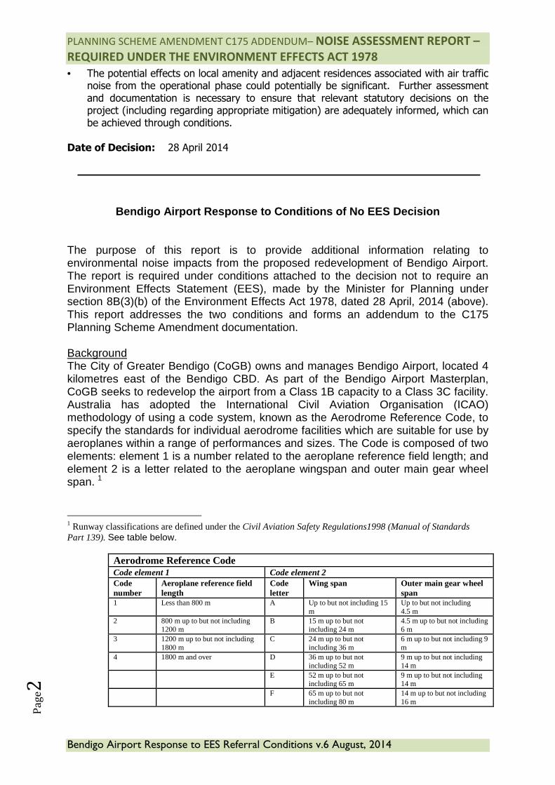
The purpose of this report is to provide additional information relating to environmental noise impacts from the proposed redevelopment of Bendigo Airport. The report is required under conditions attached to the decision not to require an Environment Effects Statement (EES), made by the Minister for Planning under section 8B(3)(b) of the Environment Effects Act 1978, dated 28 April, 2014 (above). This report addresses the two conditions and forms an addendum to the C175 Planning Scheme Amendment documentation. Background The City of Greater Bendigo (CoGB) owns and manages Bendigo Airport, located 4 kilometres east of the Bendigo CBD. As part of the Bendigo Airport Masterplan, CoGB seeks to redevelop the airport from a Class 1B capacity to a Class 3C facility. Australia has adopted the International Civil Aviation Organisation (ICAO) methodology of using a code system, known as the Aerodrome Reference Code, to specify the standards for individual aerodrome facilities which are suitable for use by aeroplanes within a range of performances and sizes. The Code is composed of two elements: element 1 is a number related to the aeroplane reference field length; and element 2 is a letter related to the aeroplane wingspan and outer main gear wheel span. 1
1 Runway classifications are defined under the Civil Aviation Safety Regulations1998 (Manual of Standards Part 139). See table below.
Aerodrome Reference Code Code element 1 Code element 2 Code number
Aeroplane reference field length
Code letter
Wing span Outer main gear wheel span
1 Less than 800 m A Up to but not including 15 m
Up to but not including 4.5 m
2 800 m up to but not including 1200 m
B 15 m up to but not including 24 m
4.5 m up to but not including 6 m
3 1200 m up to but not including 1800 m
C 24 m up to but not including 36 m
6 m up to but not including 9 m
4 1800 m and over D 36 m up to but not including 52 m
9 m up to but not including 14 m
E 52 m up to but not including 65 m
9 m up to but not including 14 m
F 65 m up to but not including 80 m
14 m up to but not including 16 m
PLANNING SCHEME AMENDMENT C175 ADDENDUM– NOISE ASSESSMENT REPORT –
REQUIRED UNDER THE ENVIRONMENT EFFECTS ACT 1978
Bendigo Airport Response to EES Referral Conditions v.6 August, 2014
Pa
ge3
The project primarily involves replacing the 1,135m x 18m runway with a 1,600m x 30m primary runway and associated infrastructure. The increased capacity will allow larger, more commercially viable aircraft to operate from Bendigo as well as ensure ongoing service provision for Emergency Services and General Aviation (GA) operations. It is worth noting the largest aircraft catered for on the current facility carries only 9 passengers with a pavement strength capacity of 5,700 kg Maximum Take Off Weight (MTOW). The proposed replacement runway can cater for up to a Dash 8 – Q400 (74 seats) and up to 29,000 MTOW. Noise assessment for the proposed new runway, including its capacity has been prepared through the Australian Noise Exposure Forecast (ANEF) report. The ANEF considers the likely size, frequency and ultimately the noise exposure from all aircraft capable of operating at Bendigo Airport. To facilitate the redevelopment of the airport, a Planning Scheme Amendment is required to rezone land, and alter the position of Planning Scheme Overlays, reflecting the location of the new runway, as well as several minor adjustments for the planning ordinance to better reflect the operations of the airport. The authorisation request to prepare an Amendment was lodged in early 2014 and CoGB has received authorisation from the Minister for Planning to prepare the Amendment. The proponent (CoGB) also referred the project under the Environment Effects Act 1978, seeking a decision from the Minister for Planning on the requirement for an Environment Effects Statement. The Minister set out conditions in his decision not to require an EES, which are responded to below. This report will form an addendum to the C175 PSA Planning Report as part of the amendment documentation for exhibition purposes in August 2014 as a direct response to the conditions contained in the EES decision.
i. The likely aircraft noise levels to be generated when the Airport is operating at the ultimate capacity being proposed for approval
CoGB has used the Australian Noise Exposure Forecast (ANEF) system to investigate and demonstrate the likely aircraft noise levels based on the proposed development. An ANEF was produced in 2000 to inform noise levels for Bendigo Airport’s current operations and a second ANEF in 2012 to inform noise levels for the proposed upgrade. See Attachment B (ANEF 2000) and refer Tables 1 & 2 (forecast flight operations) There are three main types of ANEF typically in use in Australia:
• Standard ANEF (typically used for regional General Aviation (GA) aerodromes where noise levels are predictable up to 20 years);
• Long Range ANEF (typically used for larger aerodromes where noise levels are perceived to be a major issue, beyond 20 years); and
PLANNING SCHEME AMENDMENT C175 ADDENDUM– NOISE ASSESSMENT REPORT –
REQUIRED UNDER THE ENVIRONMENT EFFECTS ACT 1978
Bendigo Airport Response to EES Referral Conditions v.6 August, 2014
Pa
ge4
• Ultimate Capacity ANEF (typically used for major airports to predict noise levels likely if the airport is expected to operate at its ultimate practical capacity in the future).
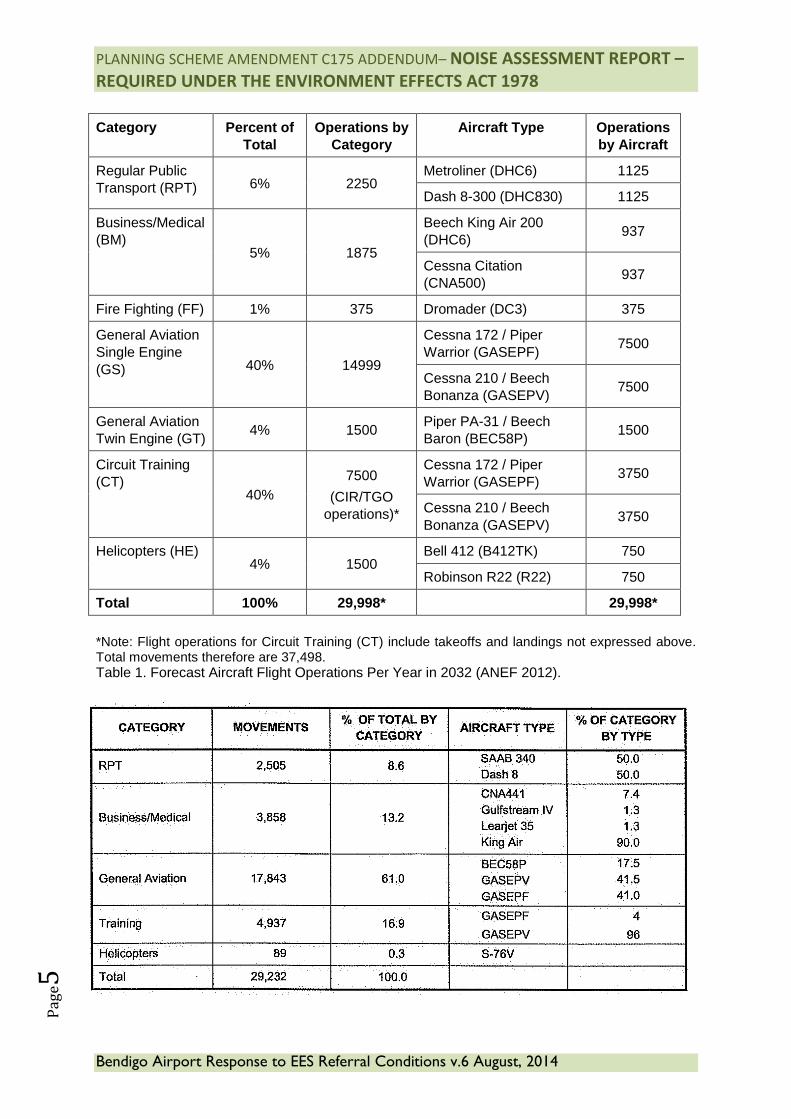
In 2012 Bendigo Airport undertook a Standard ANEF following consultation with the then Victorian Department of Business and Innovation. It was agreed at the time that the scale of the project (and thereby future operations) did not require a Long Range or Ultimate Capacity ANEF. Refer to attachment A. In order to understand the likely noise emanating from Bendigo Airport at its foreseeable practical capacity, the ANEF and subsequent contours have informed appropriate land use and mitigation on and surrounding the airport. Typically ANEFs for small regional General Aviation airports are for a 20 year period because beyond this horizon it is not possible to predict with any degree of confidence or certainty the likely nature of aircraft activity at the airport, or whether it will ever reach capacity. Table 1 below illustrates the number of aircraft movements likely in the year 2032 by aircraft type. The ANEF has used these movement numbers as assumptions in developing analysis of where noise is most likely to occur on and surrounding Bendigo Airport. Table 2 illustrates the projected flight numbers likely in the year 2020, based on the ANEF 2000.Both reports use standard methodologies to derive these numbers. Whilst very similar as a total quantum of movements, it is unlikely the 2000 projections were ever likely to occur given the current state of runway infrastructure. It is also worth noting the similarity in noise contours as shown at Maps 2 (ANEF 2012 contours) and 3 (ANEF 2000 contours).
The forecast total of 29,998 flight operations in 2032 is well within the airport’s proposed infrastructure capacity and likely represents its practical capacity to the forecast outlook.
PLANNING SCHEME AMENDMENT C175 ADDENDUM– NOISE ASSESSMENT REPORT –
REQUIRED UNDER THE ENVIRONMENT EFFECTS ACT 1978
Bendigo Airport Response to EES Referral Conditions v.6 August, 2014
Pa
ge5
Category Percent of
Total Operations by
Category Aircraft Type Operations
by Aircraft
Regular Public Transport (RPT) 6% 2250
Metroliner (DHC6) 1125
Dash 8-300 (DHC830) 1125
Business/Medical (BM)
5% 1875
Beech King Air 200 (DHC6)
937
Cessna Citation (CNA500)
937
Fire Fighting (FF) 1% 375 Dromader (DC3) 375
General Aviation Single Engine (GS) 40% 14999
Cessna 172 / Piper Warrior (GASEPF)
7500
Cessna 210 / Beech Bonanza (GASEPV)
7500
General Aviation Twin Engine (GT)
4% 1500 Piper PA-31 / Beech Baron (BEC58P)
1500
Circuit Training (CT)
40% 7500
(CIR/TGO operations)*
Cessna 172 / Piper Warrior (GASEPF)
3750
Cessna 210 / Beech Bonanza (GASEPV)
3750
Helicopters (HE) 4% 1500
Bell 412 (B412TK) 750
Robinson R22 (R22) 750
Total 100% 29,998* 29,998*
*Note: Flight operations for Circuit Training (CT) include takeoffs and landings not expressed above. Total movements therefore are 37,498. Table 1. Forecast Aircraft Flight Operations Per Year in 2032 (ANEF 2012).
PLANNING SCHEME AMENDMENT C175 ADDENDUM– NOISE ASSESSMENT REPORT –
REQUIRED UNDER THE ENVIRONMENT EFFECTS ACT 1978
Bendigo Airport Response to EES Referral Conditions v.6 August, 2014
Pa
ge6
Table 2. Forecast Aircraft Flight Operations Per Year in 2020 (ANEF 2000) The endorsed Australian Noise Exposure Forecast (ANEF) prepared for Bendigo Airport in 2012 shows the forecast noise exposure levels for the foreseeable future (to 2032) based on noise modelling approved by Airservices Australia. The role of Airservices Australia is to provide an avenue for aircraft noise complaints as well as providing a range of services to airports, airlines, pilots and the aviation industry, including ensuring the technical accuracy of noise forecasts for each airport.
What is an ANEF and how is it produced?
An ANEF is a contour map showing the forecast of aircraft noise levels that are expected to exist around an airport in the future. The contour set usually relates to a particular year, generally about 20 years from the date of issue. An ANEF generally requires review at regular intervals (about 5 years) to ensure its continuing validity. Prior to a set of contours becoming an ANEF they must be endorsed for technical accuracy by Airservices Australia.2
ANEF contours are prepared using the Integrated Noise Model (INM) computer program. The INM was developed by the US Federal Aviation Administration as a means of modelling and evaluating the impact of aircraft noise around airports.
In order to produce an ANEF for a particular airport data relating to the airport and the forecast aircraft operations is entered into the program. The data used to calculate the noise contours includes the airport’s runway configuration, meteorological conditions, flight tracks, aircraft types, number of flight operations, runway and track usage and time of day of operations. Once this data is entered, and the prescribed ANEF parameter settings are entered, the program is run to produce the contours chart (see Map 1).
The INM includes noise profiles for a large number of aircraft types that are used at airports around the world. However, the INM’s database of aircraft does not include every aircraft type. For example, the INM does not include the Dash 8-Q400 aircraft. For modelling purposes where a particular aircraft type is not available in the INM an appropriate substitute aircraft must be selected, using either the INM’s substitute aircraft or a substitute aircraft approved by Airservices. In the case of the Dash 8-Q400, Airservices has approved the use of the Dash 8-300 as an appropriate substitute. The Q400 utilises modern turbo prop design to reduce environmental
2 It is Australian Government policy that Australian Noise Exposure Forecast (ANEF) contours and the associated land use
compatibility advice be used as the land use planning criteria around Australian airports. This policy was announced in the
Government's response to the House of Representatives Select Committee on Aircraft Noise (HoRSCAN) recommendations in
September 1990. The ANEF system is the basis of Australian Standard AS 2021-2000: Acoustics - Aircraft Noise Intrusion -
Building Siting and Construction (AS2021).
Prior to HoRSCAN (in 1982) the National Acoustic Laboratories released a major study, Aircraft Noise in Australia: A Survey of
Community Reaction (the NAL Study), regarding the impacts of aircraft noise on residential communities in Australia. The
results of this study were subsequently used in framing the Australian Standard and land use planning controls around
Australia’s airports.
PLANNING SCHEME AMENDMENT C175 ADDENDUM– NOISE ASSESSMENT REPORT –
REQUIRED UNDER THE ENVIRONMENT EFFECTS ACT 1978
Bendigo Airport Response to EES Referral Conditions v.6 August, 2014
Pa
ge7
noise levels and is widely considered to be one of the quietest commercial aircraft types available and is comparable to the Q300. It should also be noted that the INM includes 1125 operations per year for the Q400 which translates to up to 6 RPT movements per day, it is considered this to be quite optimistic for future operations at Bendigo. The Dash 8 Q400 emits the same noise levels as a Cessna 172 and less noise than many aircraft currently operating from Bendigo airport including the Cessna CitationII, Beech 200 and Piper PA-283.
What do the ANEF contours mean?
ANEF charts are simply plans of the airport and the surrounding localities on which noise exposure contours of 20, 25, 30, 35 and 40 ANEF units have been drawn based on an INM study. These contours indicate land areas around an airport that are likely to be exposed to aircraft noise; the higher the ANEF value, the greater the noise exposure.
The ANEF chart shows the cumulative noise effect of a full year of aircraft operations so that seasonal changes in weather patterns and aircraft movements are taken into account. The resulting contours are therefore a measure of the total noise exposure over a 12-month period divided by 365 to show an average annual day. They do not represent the maximum exposure on any day or the maximum exposure caused by a single aircraft.
Within the area from 20 ANEF to 25 ANEF, aircraft noise exposure starts to emerge as an environmental problem, while above 25 ANEF the noise exposure becomes progressively more severe.
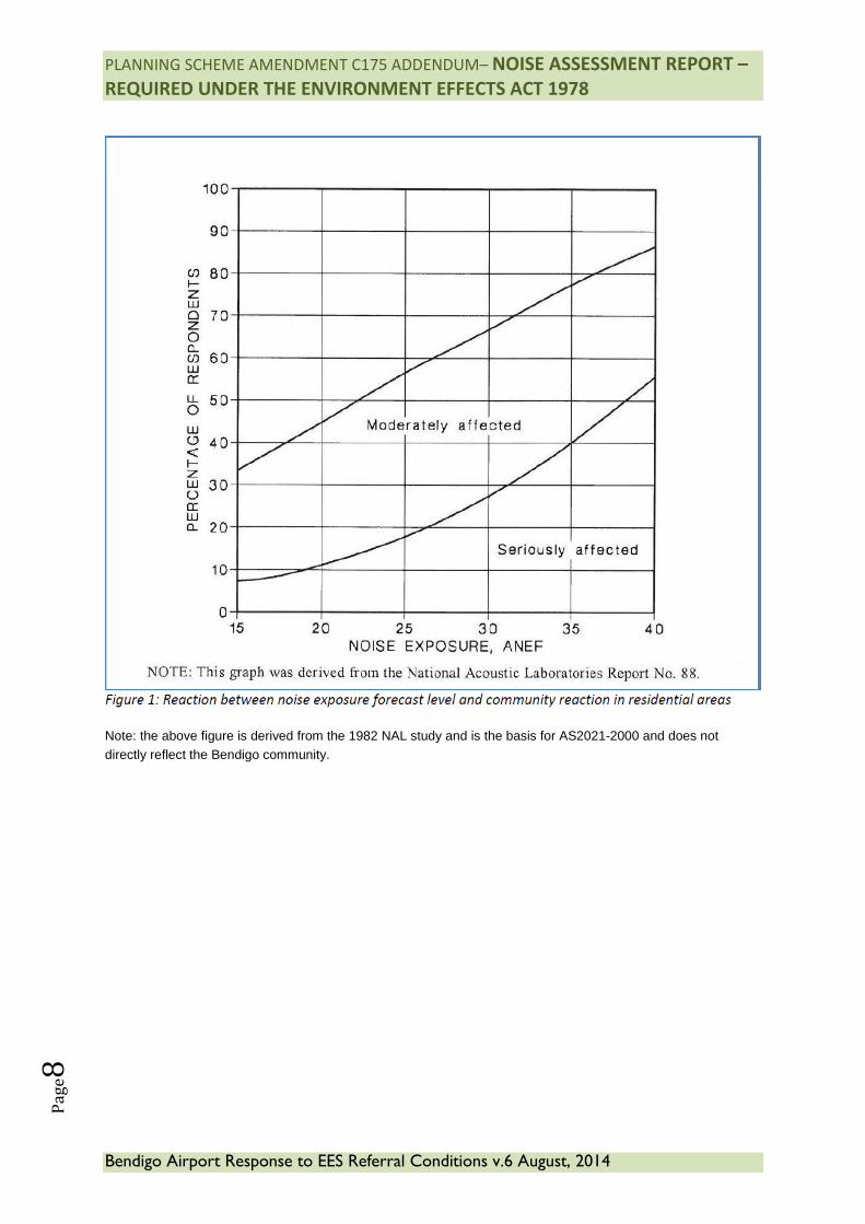
The NAL Study referred to earlier found that at the 20 ANEF level, it is estimated that approximately 11 per cent of people will be seriously affected by aircraft noise and approximately 45 per cent of people moderately affected by aircraft noise. At the 25 ANEF level, it is estimated that approximately 18 per cent of people will be seriously affected by aircraft noise and approximately 56 per cent of people moderately affected by aircraft noise. These results are shown in Figure 1 below which is derived from the NAL Study. Please note this study was produced as a national study and informs the development of AS2021-2000, and was not produced for Bendigo Airport.
It should be noted that the figure below also shows that at the 15 ANEF level, approximately 8 per cent of people will be seriously affected by aircraft noise and approximately 34 per cent of people moderately affected.AS2021 states that within the 20-25 ANEF contours some people may find that the land is not compatible with residential or educational uses due to aircraft noise issues. As such, within this ANEF zone AS2021 states that these and other noise sensitive uses are “conditionally acceptable” and should be subject to noise attenuation requirements. Within the 25 ANEF contour a much greater proportion of people may find the land is not compatible with residential or educational uses, which is the reason why AS2021 states that these and other noise sensitive uses are “unacceptable” within this ANEF zone.
Table 3 below sets out all of the land use recommendations (building site acceptability) contained in AS2021. 3 US Federal Aviation Administration doc ref AC36-3H (April, 2012)
PLANNING SCHEME AMENDMENT C175 ADDENDUM– NOISE ASSESSMENT REPORT –
REQUIRED UNDER THE ENVIRONMENT EFFECTS ACT 1978
Bendigo Airport Response to EES Referral Conditions v.6 August, 2014
Pa
ge8
Note: the above figure is derived from the 1982 NAL study and is the basis for AS2021-2000 and does not directly reflect the Bendigo community.
PLANNING SCHEME AMENDMENT C175 ADDENDUM– NOISE ASSESSMENT REPORT –
REQUIRED UNDER THE ENVIRONMENT EFFECTS ACT 1978
Bendigo Airport Response to EES Referral Conditions v.6 August, 2014
Pa
ge9
Building Type
ANEF Zone of Site
Acceptable Conditional Unacceptable
House, home unit, flat, caravan park
Less than 20 ANEF 20 to 25 ANEF Greater than 25 ANEF
Hotel, motel, hostel Less than 25 ANEF 25 to 30 ANEF Greater than 30 ANEF
School, university Less than 20 ANEF 20 to 25 ANEF Greater than 25 ANEF
Hospital, nursing home
Less than 20 ANEF 20 to 25 ANEF Greater than 25 ANEF
Public building Less than 20 ANEF 20 to 30 ANEF Greater than 30 ANEF
Commercial building
Less than 25 ANEF 25 to 35 ANEF Greater than 35 ANEF
Light industrial Less than 30 ANEF 30 to 40 ANEF Greater than 40 ANEF
Other industrial Acceptable in all ANEF zones
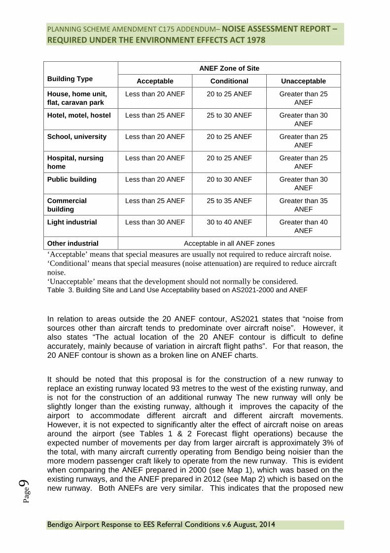
‘Acceptable’ means that special measures are usually not required to reduce aircraft noise. ‘Conditional’ means that special measures (noise attenuation) are required to reduce aircraft noise. ‘Unacceptable’ means that the development should not normally be considered. Table 3. Building Site and Land Use Acceptability based on AS2021-2000 and ANEF
In relation to areas outside the 20 ANEF contour, AS2021 states that “noise from sources other than aircraft tends to predominate over aircraft noise”. However, it also states “The actual location of the 20 ANEF contour is difficult to define accurately, mainly because of variation in aircraft flight paths”. For that reason, the 20 ANEF contour is shown as a broken line on ANEF charts.
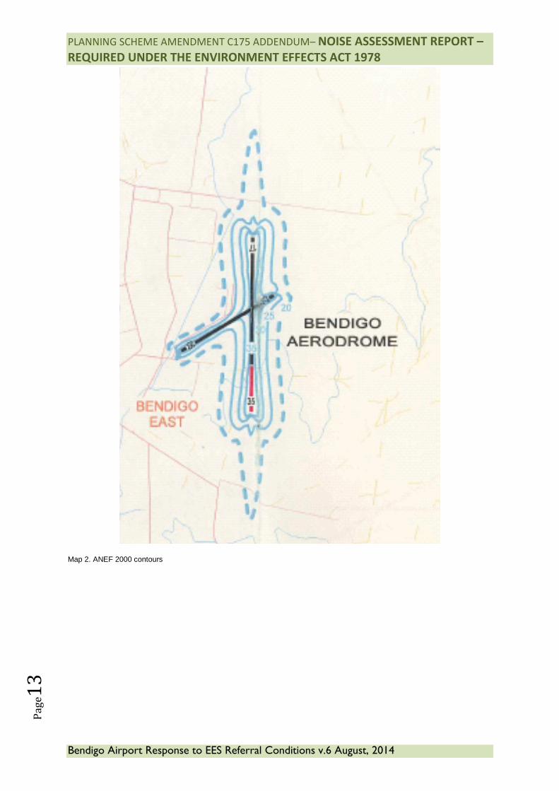
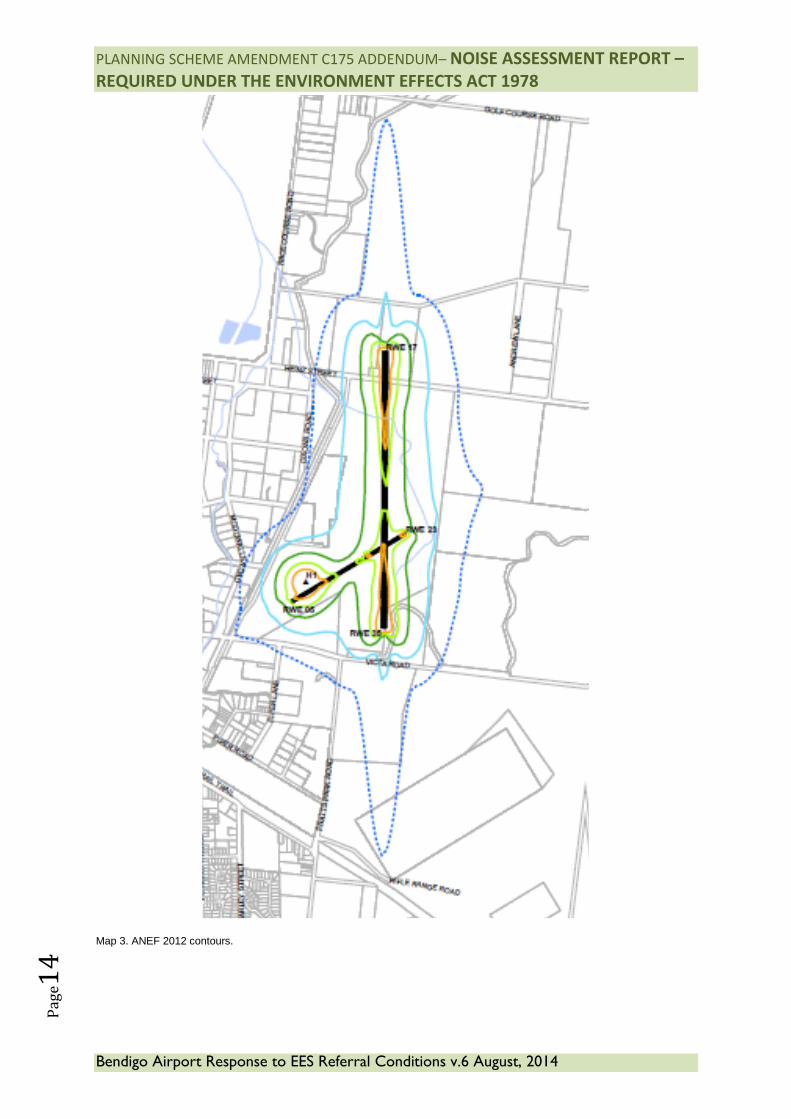
It should be noted that this proposal is for the construction of a new runway to replace an existing runway located 93 metres to the west of the existing runway, and is not for the construction of an additional runway The new runway will only be slightly longer than the existing runway, although it improves the capacity of the airport to accommodate different aircraft and different aircraft movements. However, it is not expected to significantly alter the effect of aircraft noise on areas around the airport (see Tables 1 & 2 Forecast flight operations) because the expected number of movements per day from larger aircraft is approximately 3% of the total, with many aircraft currently operating from Bendigo being noisier than the more modern passenger craft likely to operate from the new runway. This is evident when comparing the ANEF prepared in 2000 (see Map 1), which was based on the existing runways, and the ANEF prepared in 2012 (see Map 2) which is based on the new runway. Both ANEFs are very similar. This indicates that the proposed new
PLANNING SCHEME AMENDMENT C175 ADDENDUM– NOISE ASSESSMENT REPORT –
REQUIRED UNDER THE ENVIRONMENT EFFECTS ACT 1978
Bendigo Airport Response to EES Referral Conditions v.6 August, 2014
Pa
ge1
0
runway will have a negligible noise impact when compared to the current situation (37,498 movements compared to 29,998 movements).
ii. The effects of the likely noise levels on sensitive receptors The term sensitive receptor refers to land that is used primarily for residential purposes. The definition is further described in Australian Standard 2021- Acoustics – Aircraft Noise Intrusion – Building Siting and Construction. The standard also refers to land used for hospitals and schools. The ANEF directly references the AS2021 which is incorporated into the Greater Bendigo Planning Scheme to protect both airport operations and residential areas. The ANEF 2012 chart for Bendigo Airport shows where the higher levels of aircraft noise are forecast. Within the 20-25 ANEF contours some people may find that the land is not compatible with residential or educational uses due to aircraft noise issues. As such, within this ANEF zone AS2021 states that these uses are “conditionally acceptable”. Within the 25 ANEF contour a much greater proportion of people may find the land is not compatible with residential or educational uses, which is the reason why AS2021 states that these uses are “unacceptable” within this ANEF zone. It should be noted that the ANEF contours are largely contained within the boundaries of Bendigo Airport, and only extend outside the airport site for a distance of about 1,000 metres north and south of the airport in line with the new runway, and slightly to the east and west. These areas are largely Crown Land and not zoned for residential use. It should be noted however, that aircraft noise does not stop at a contour line on a map. Experience has shown that ANEF contours do not provide a complete picture of the areas where residents are likely to have an adverse reaction to aircraft noise. The change in location of the main north/south (17/35) runway will have negligible effects on the amenity of the immediate area and sensitive receptors. The ANEF contours indicate the main approach and landing paths to the north and south of the runway are over Public Conservation and Recreation Zone Crown Land. The land immediately to the north of Heinz Street, which has been recently acquired by CoGB for the purposes of the redevelopment, is currently zoned Rural Living Zone, and is subject to rezoning to Special Use (Schedule 7) as part of the amendment process. The airport site is located at the edge of the urban area approximately 4 kilometres to the north east of the Bendigo CBD. The site is surrounded by a range of uses predominantly low density residential to the west, industrial to the south, and rural living and conservation to the north east. Map 2 illustrates the local context. The East Bendigo industrial precinct as identified in Clause 21.07 of the MSS covers an area of approximately 328 hectares. The land is zoned Industrial 1 (IN1Z) and Industrial 3 (IN3Z). It is the largest industrial precinct in Greater Bendigo and contains major industries such as Motherson Elastomers, Keech Castings and Bendigo Brick.
PLANNING SCHEME AMENDMENT C175 ADDENDUM– NOISE ASSESSMENT REPORT –
REQUIRED UNDER THE ENVIRONMENT EFFECTS ACT 1978
Bendigo Airport Response to EES Referral Conditions v.6 August, 2014
Pa
ge1
1
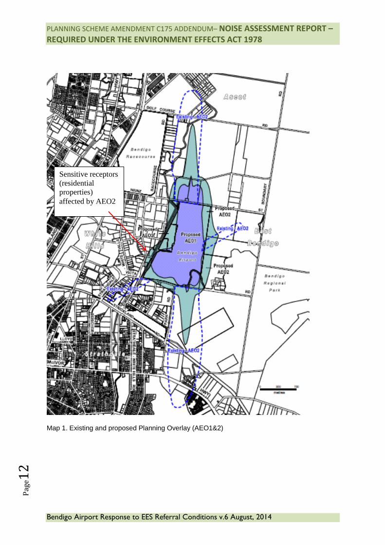
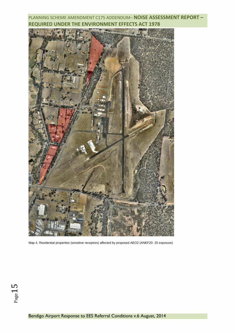
Bendigo Regional Park surrounds most of Bendigo. It is characterized by Box- Ironbark Forest EVC vegetation and supports populations of threatened flora and fauna species. It provides recreational opportunities for a range of activities. (Environment Conservation Council, 2002) and is managed by Parks Victoria. The land to the west of the Airport has been substantially developed for low density residential development. Most of the lots are between 4,000m2 (0.4 hectare) and 20,000m2 (2 hectares). Many are used for horse keeping. A number of the lots near the Airport have been used for poultry production. Additional (non-airport related) Planning Scheme Overlays exist of some of this land which restricts further subdivision to a minimum lot size of 1 hectare. As a result an increase in sensitive land uses in proximity to the airport is unlikely. Victa Road is a local road that links the Wellsford Industrial Estate to the east of the Airport with Rohs Road to the west of the Airport. It provides an important east-west link through the East Bendigo industrial precinct. The road will ultimately form part of a three stage East Bendigo arterial link road. Stage 1 has been completed. It is expected that increased activity will occur in this precinct as available industrial land is developed. Heinz Street a local road that links rural living and low density residential development adjacent to the Airport with the Midland Highway to the west. It is sealed to the west of the subject site and is gravelled for its remaining length to the east. Seven rural residential properties are located along Heinz Street east of the airport. Twelve (12) residential properties will be affected by the new Airport Environs Overlay Schedule 2 (AEO2), of a total of 33 properties affected. These properties are primarily in the Low Density Residential Zone to the west of the airport. The balance of the properties are Industrial or public land. Again, this does not indicate that no aircraft noise will be experienced outside or beyond the boundaries of these 12 properties. 11 of these properties are developed (a single residence) and one property has a Land Subject to Inundation Overlay applies and is unlikely to ever be built on. The limited number of residential properties affected by the overlay, and only by AEO2, reflects the view that noise impacts on residential communities will not be significant. There are no residential properties affected by the AEO1. The current extent of the AEO2 is applied to a large number of properties and does not directly reflect the ANEF 2000 modelling. The extent of the proposed AEO2 will contract substantially to correspond with the ANEF 2012. This will be applied to 33 properties, 12 of which are residential. This is shown at Map 4. For areas outside but near to the 20 ANEF contour, CoGB will continue to actively foster and encourage open communication with all residents to allow opportunity for comment as developments take place. Through the Planning Scheme Amendment exhibition stage, residents outside the 20 ANEF (AEO2) areas will be contacted directly to participate in any discussions related to the project. To date Bendigo Airport has already undertaken to hold a number of meetings with local residents (including those outside the immediate area) to have informal conversations about what is proposed and how they may or may not be affected, including noise.
PLANNING SCHEME AMENDMENT C175 ADDENDUM– NOISE ASSESSMENT REPORT –
REQUIRED UNDER THE ENVIRONMENT EFFECTS ACT 1978
Bendigo Airport Response to EES Referral Conditions v.6 August, 2014
Pa
ge1
2
Map 1. Existing and proposed Planning Overlay (AEO1&2)
Sensitive receptors (residential properties) affected by AEO2
PLANNING SCHEME AMENDMENT C175 ADDENDUM– NOISE ASSESSMENT REPORT –
REQUIRED UNDER THE ENVIRONMENT EFFECTS ACT 1978
Bendigo Airport Response to EES Referral Conditions v.6 August, 2014
Pa
ge1
3
Map 2. ANEF 2000 contours
PLANNING SCHEME AMENDMENT C175 ADDENDUM– NOISE ASSESSMENT REPORT –
REQUIRED UNDER THE ENVIRONMENT EFFECTS ACT 1978
Bendigo Airport Response to EES Referral Conditions v.6 August, 2014
Pa
ge1
4
Map 3. ANEF 2012 contours.
PLANNING SCHEME AMENDMENT C175 ADDENDUM– NOISE ASSESSMENT REPORT –
REQUIRED UNDER THE ENVIRONMENT EFFECTS ACT 1978
Bendigo Airport Response to EES Referral Conditions v.6 August, 2014
Pa
ge1
5
Map 4. Residential properties (sensitive receptors) affected by proposed AEO2 (ANEF20- 25 exposure)
PLANNING SCHEME AMENDMENT C175 ADDENDUM– NOISE ASSESSMENT REPORT –
REQUIRED UNDER THE ENVIRONMENT EFFECTS ACT 1978
Bendigo Airport Response to EES Referral Conditions v.6 August, 2014
Pa
ge1
6
iii. Suitable mitigation measures and/or controls being proposed The proposed new Airport Environs Overlays (AEO1 & AEO2) mirror the noise contour patterns derived from the ANEF. Existing dwellings under the new overlays are not required to implement any changes to ameliorate noise effects from aircraft. Any new dwelling on a property covered by AEO1 or AEO2 however, must implement noise attenuation measures consistent with AS2021, and obtain a planning permit to do so. Such measures include building siting within a lot and construction utilising approved glazing, insulation and certain materials. To mitigate the effects of aircraft noise the Airport Environs Overlay (AEO) will be applied to the areas affected by the ANEF contours in accordance with established planning practice in Victoria. The purpose of the AEO is: • To implement the State Planning Policy Framework and the Local Planning
Policy Framework, including the Municipal Strategic Statement and local planning policies.
• To identify areas which are or will be subject to high levels of aircraft noise, including areas where the use of land for uses sensitive to aircraft noise will need to be restricted.
• To ensure that land use and development are compatible with the operation of airports in accordance with the appropriate airport strategy or master plan and with safe air navigation for aircraft approaching and departing the airfield.
• To assist in shielding people from the impact of aircraft noise by requiring appropriate noise attenuation measures in new dwellings and other noise sensitive buildings.
• To limit the number of people residing in the area or likely to be subject to significant levels of aircraft noise.
The AEO has two schedules. Schedule 1 is applied to areas inside the 25 ANEF contour and Schedule 2 is applied to areas between the 20 and 25 ANEF contours. In accordance with AS2021, the AEO1 controls are more restrictive than those of AEO2. For example, under AEO1 certain noise-sensitive uses such as schools, hospitals and certain types of accommodation are prohibited, whereas AEO2 requires a permit for these uses. The AEO requires any new building to be constructed to comply with any noise attenuation measures required by AS2021. Uses that are “conditionally acceptable” will require noise attenuation measures to reduce the impact of aircraft noise. Flight Procedures. Airservices Australia publishes approved flight procedures for each airport in Australia. These procedures contain local regulations applicable to local conditions. Bendigo Airport’s flight procedures contain two local regulations which are designed to mitigate and minimise amenity impacts on residential areas.
PLANNING SCHEME AMENDMENT C175 ADDENDUM– NOISE ASSESSMENT REPORT –
REQUIRED UNDER THE ENVIRONMENT EFFECTS ACT 1978
Bendigo Airport Response to EES Referral Conditions v.6 August, 2014
Pa
ge1
7
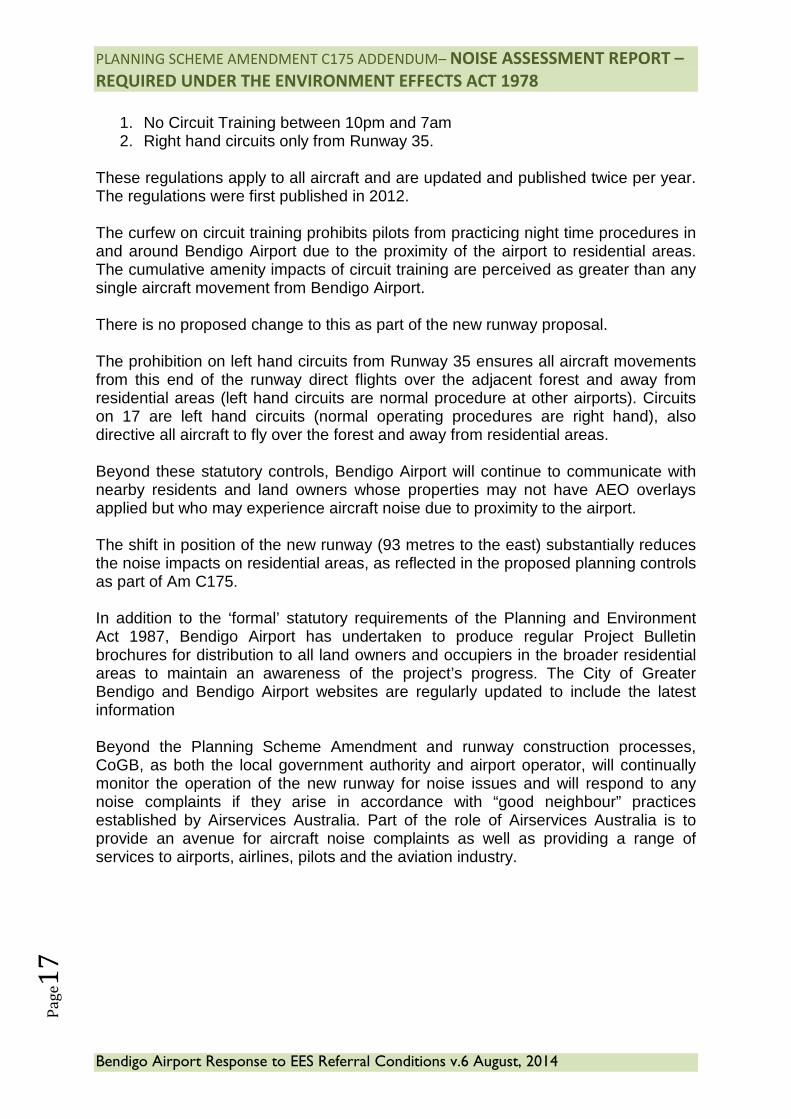
1. No Circuit Training between 10pm and 7am 2. Right hand circuits only from Runway 35.
These regulations apply to all aircraft and are updated and published twice per year. The regulations were first published in 2012. The curfew on circuit training prohibits pilots from practicing night time procedures in and around Bendigo Airport due to the proximity of the airport to residential areas. The cumulative amenity impacts of circuit training are perceived as greater than any single aircraft movement from Bendigo Airport. There is no proposed change to this as part of the new runway proposal. The prohibition on left hand circuits from Runway 35 ensures all aircraft movements from this end of the runway direct flights over the adjacent forest and away from residential areas (left hand circuits are normal procedure at other airports). Circuits on 17 are left hand circuits (normal operating procedures are right hand), also directive all aircraft to fly over the forest and away from residential areas. Beyond these statutory controls, Bendigo Airport will continue to communicate with nearby residents and land owners whose properties may not have AEO overlays applied but who may experience aircraft noise due to proximity to the airport. The shift in position of the new runway (93 metres to the east) substantially reduces the noise impacts on residential areas, as reflected in the proposed planning controls as part of Am C175. In addition to the ‘formal’ statutory requirements of the Planning and Environment Act 1987, Bendigo Airport has undertaken to produce regular Project Bulletin brochures for distribution to all land owners and occupiers in the broader residential areas to maintain an awareness of the project’s progress. The City of Greater Bendigo and Bendigo Airport websites are regularly updated to include the latest information Beyond the Planning Scheme Amendment and runway construction processes, CoGB, as both the local government authority and airport operator, will continually monitor the operation of the new runway for noise issues and will respond to any noise complaints if they arise in accordance with “good neighbour” practices established by Airservices Australia. Part of the role of Airservices Australia is to provide an avenue for aircraft noise complaints as well as providing a range of services to airports, airlines, pilots and the aviation industry.
PLANNING SCHEME AMENDMENT C175 ADDENDUM– NOISE ASSESSMENT REPORT –
REQUIRED UNDER THE ENVIRONMENT EFFECTS ACT 1978
Bendigo Airport Response to EES Referral Conditions v.6 August, 2014
Pa
ge1
8
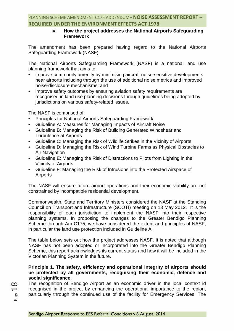
iv. How the project addresses the National Airports Safeguarding Framework
The amendment has been prepared having regard to the National Airports Safeguarding Framework (NASF). The National Airports Safeguarding Framework (NASF) is a national land use planning framework that aims to: • improve community amenity by minimising aircraft noise-sensitive developments
near airports including through the use of additional noise metrics and improved noise-disclosure mechanisms; and
• improve safety outcomes by ensuring aviation safety requirements are recognised in land use planning decisions through guidelines being adopted by jurisdictions on various safety-related issues.
The NASF is comprised of: • Principles for National Airports Safeguarding Framework • Guideline A: Measures for Managing Impacts of Aircraft Noise • Guideline B: Managing the Risk of Building Generated Windshear and
Turbulence at Airports • Guideline C: Managing the Risk of Wildlife Strikes in the Vicinity of Airports • Guideline D: Managing the Risk of Wind Turbine Farms as Physical Obstacles to
Air Navigation • Guideline E: Managing the Risk of Distractions to Pilots from Lighting in the
Vicinity of Airports • Guideline F: Managing the Risk of Intrusions into the Protected Airspace of
Airports The NASF will ensure future airport operations and their economic viability are not constrained by incompatible residential development. Commonwealth, State and Territory Ministers considered the NASF at the Standing Council on Transport and Infrastructure (SCOTI) meeting on 18 May 2012. It is the responsibility of each jurisdiction to implement the NASF into their respective planning systems. In proposing the changes to the Greater Bendigo Planning Scheme through Am C175, we have considered the extent and principles of NASF, in particular the land use protection included in Guideline A. The table below sets out how the project addresses NASF. It is noted that although NASF has not been adopted or incorporated into the Greater Bendigo Planning Scheme, this report acknowledges its current status and how it will be included in the Victorian Planning System in the future. Principle 1. The safety, efficiency and operational integrity of airports should be protected by all governments, recognising their economic, defence and social significance. The recognition of Bendigo Airport as an economic driver in the local context id recognised in the project by enhancing the operational importance to the region, particularly through the continued use of the facility for Emergency Services. The
PLANNING SCHEME AMENDMENT C175 ADDENDUM– NOISE ASSESSMENT REPORT –
REQUIRED UNDER THE ENVIRONMENT EFFECTS ACT 1978
Bendigo Airport Response to EES Referral Conditions v.6 August, 2014
Pa
ge1
9
project (and planning instrument changes reflected in Am C175) ensures the ongoing operational integrity of the facility. Principle 2. Airports, governments and local communities should share responsibility to ensure that airport planning is integrated with local and regional planning. Bendigo Airport has worked closely over the life of this project to ensure the local community and all relevant Government Departments have included the future operations of the airport are foremost enshrined in strategic planning, including references in the Loddon Mallee (Southern Region) Regional Growth Plan, as well as represented and protected in the draft Integrated Transport and Land Use Strategy (CoGB), Bendigo Airport Masterplan and MSS. Principle 3. Governments at all levels should align land use planning and building requirements in the vicinity of airports. Current land use planning provisions designed to protect operations at airports in Victoria (AEO) are aligned with relevant Australian Standards to ensure noise attenuation measures and building siting issues are taken into account within the vicinity of airports. Bendigo Airport is adjacent to a small number of already developed Low Density Residential lots and further residential development is unlikely or will be subject to planning approval and Australian Standard AS2021-2000. Principle 4. Land use planning processes should balance and protect both airport/aviation operations and community safety and amenity expectations. The ANEF and OLS systems are the accepted protection measures which are applied to land on and surrounding Bendigo Airport through the Greater Bendigo Planning Scheme DDO and AEO Overlays. These tools protect both airport operations and residential amenity. Principle 5. Governments will protect operational airspace around airports in the interests of both aviation and community safety. Operational Airspace is protected through the OLS system which ensures safe, obstacle free flying areas for all aircraft movements. Greater Bendigo uses the OLS to inform any planning permit applications which may intrude into operational airspace. Am C175 aims to include the OLS document as a Reference Document to strengthen this protection. Principle 6. Strategic and statutory planning frameworks should address aircraft noise by applying a comprehensive suite of noise measures. Planning Frameworks are addressing this through the Draft Planning Policies, inclusion of these principles in Plan Melbourne and Regional Growth Plans. Principle 7. Airports should work with governments to provide comprehensive and understandable information to local communities on their operations concerning noise impacts and airspace requirements. Through the Am C175 process, Bendigo Airport has been active in consulting with all levels of Government to ensure the required redevelopment is clearly understood and how this relates to the local community. The airport has been active in engaging directly with the local community to assist in understanding any amenity issues that
PLANNING SCHEME AMENDMENT C175 ADDENDUM– NOISE ASSESSMENT REPORT –
REQUIRED UNDER THE ENVIRONMENT EFFECTS ACT 1978
Bendigo Airport Response to EES Referral Conditions v.6 August, 2014
Pa
ge2
0
may arise as a result of the redevelopment. Additionally, the planning process allows for community engagement, comment, dissemination of information and opportunity for comment.
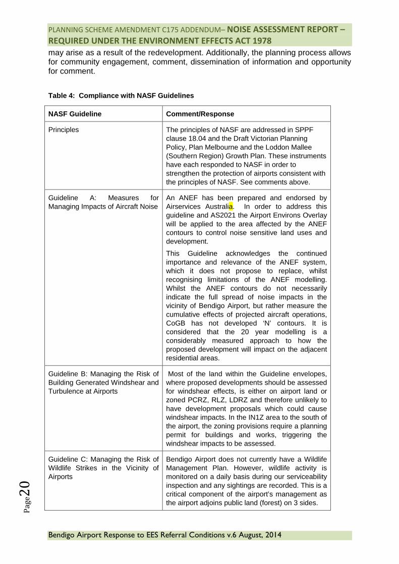
Table 4: Compliance with NASF Guidelines
NASF Guideline Comment/Response
Principles The principles of NASF are addressed in SPPF clause 18.04 and the Draft Victorian Planning Policy, Plan Melbourne and the Loddon Mallee (Southern Region) Growth Plan. These instruments have each responded to NASF in order to strengthen the protection of airports consistent with the principles of NASF. See comments above.
Guideline A: Measures for Managing Impacts of Aircraft Noise
An ANEF has been prepared and endorsed by Airservices Australia. In order to address this guideline and AS2021 the Airport Environs Overlay will be applied to the area affected by the ANEF contours to control noise sensitive land uses and development.
This Guideline acknowledges the continued importance and relevance of the ANEF system, which it does not propose to replace, whilst recognising limitations of the ANEF modelling. Whilst the ANEF contours do not necessarily indicate the full spread of noise impacts in the vicinity of Bendigo Airport, but rather measure the cumulative effects of projected aircraft operations, CoGB has not developed ‘N’ contours. It is considered that the 20 year modelling is a considerably measured approach to how the proposed development will impact on the adjacent residential areas.
Guideline B: Managing the Risk of Building Generated Windshear and Turbulence at Airports
Most of the land within the Guideline envelopes, where proposed developments should be assessed for windshear effects, is either on airport land or zoned PCRZ, RLZ, LDRZ and therefore unlikely to have development proposals which could cause windshear impacts. In the IN1Z area to the south of the airport, the zoning provisions require a planning permit for buildings and works, triggering the windshear impacts to be assessed.
Guideline C: Managing the Risk of Wildlife Strikes in the Vicinity of Airports
Bendigo Airport does not currently have a Wildlife Management Plan. However, wildlife activity is monitored on a daily basis during our serviceability inspection and any sightings are recorded. This is a critical component of the airport’s management as the airport adjoins public land (forest) on 3 sides.
PLANNING SCHEME AMENDMENT C175 ADDENDUM– NOISE ASSESSMENT REPORT –
REQUIRED UNDER THE ENVIRONMENT EFFECTS ACT 1978
Bendigo Airport Response to EES Referral Conditions v.6 August, 2014
Pa
ge2
1
Guideline D: Managing the Risk of Wind Turbine Farms as Physical Obstacles to Air Navigation
Bendigo is listed in the Schedule to Clause 52.32 of the Greater Bendigo Planning Scheme as a regional centre where wind turbines are prohibited within 5 kilometres. Being adjacent to an established urban area, it is highly unlikely a wind turbine will be constructed within the inner horizontal surface for Bendigo Airport to become an obstacle.
Guideline E: Managing the Risk of Distractions to Pilots from Lighting in the Vicinity of Airports
Greater Bendigo Planning Scheme does not have specific local policies dealing with lighting in the vicinity of the airport. The location of Bendigo Airport, surrounded by forest, residential and industrial land, allows for natural mitigation from the effects of offsite lighting hazards. The developments listed in this Guideline, such as freeway lighting, wharves, refineries and stadiums do not exist in the immediate vicinity (6 kilometres) of Bendigo Airport. The Bendigo Racecourse is witin this area but not in the flightpath of the main runway and unlikely to have an impact. There are a number of tall structures within the zones identified in Attachment 1 to this Guideline that are illuminated with beacons and published in the En Route Supplement Australia ERSA. These are unlikely to cause confusion for pilots approaching Bendigo Airport during night operations. Current lighting on runway 17/35 is Pilot Activated Lighting PAL.
Guideline F: Managing the Risk of Intrusions into the Protected Airspace of Airports
Overlay DDO1 directly reflects the surfaces included in the Obstacle Limitations Surfaces (proposed to be incorporated into the Greater Bendigo Planning Scheme) to manage the risk of intrusions into protected airspace. The inner horizontal surface radiates 4 kilometres from the Airport Reference Point at 45 metres. Any obstacle or proposed obstacle must be reported to Bendigo Airport for inclusion in the ERSA and where necessary the issuance of a NOTAM. The proposed Design and Development Overlay (Schedule 1) addresses the height controls of buildings within the approach and takeoff paths, and directly reflects the Obstacle Limitation Surfaces. The majority of land to which DDO1 applies is Crown Land and Residential 1 zone. It is therefore unlikely tall building structures will affect airport operations.
PLANNING SCHEME AMENDMENT C175 ADDENDUM– NOISE ASSESSMENT REPORT –
REQUIRED UNDER THE ENVIRONMENT EFFECTS ACT 1978
Bendigo Airport Response to EES Referral Conditions v.6 August, 2014
Pa
ge2
2
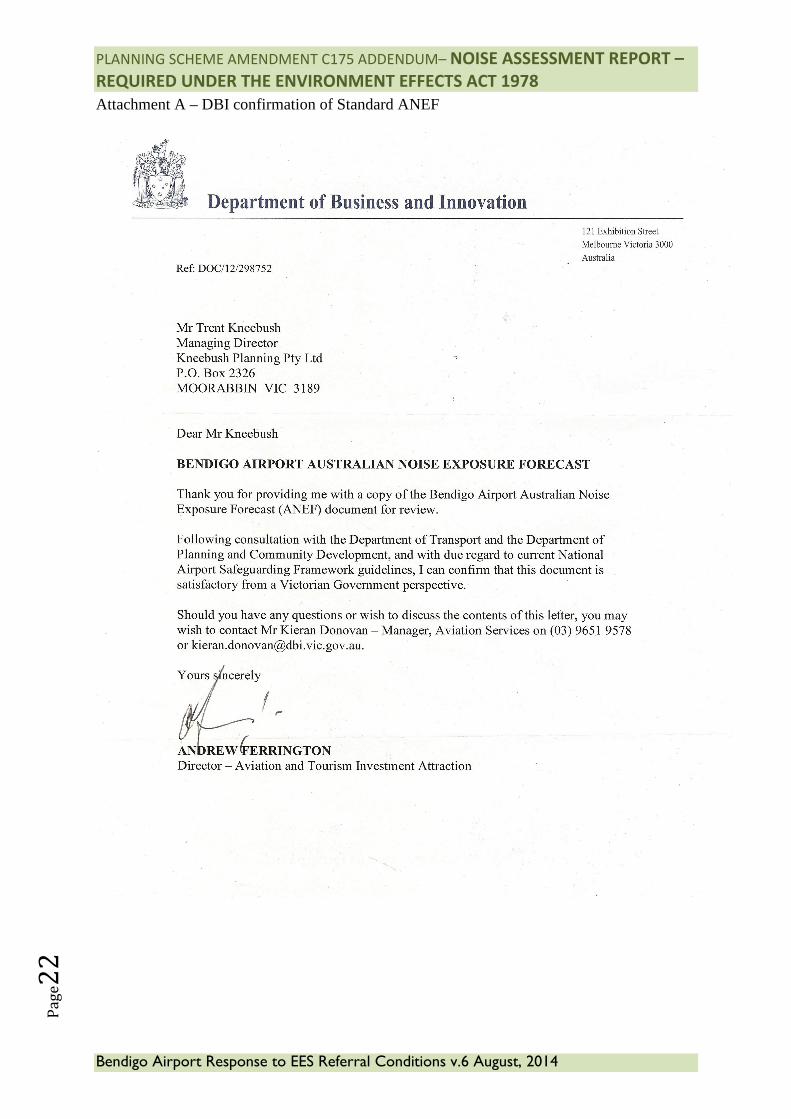
Attachment A – DBI confirmation of Standard ANEF
![[XLS]stg- · Web viewNATIONAL UCC FINANCING AMENDMENT ADDENDUM FORM UCC3AD BSI BSI UCC3ADDLAZ VMPC566 UCC-3ADD-LAZ INSTRUCTIONS NATIONAL UCC AMENDMENT ADDENDUM UCC3AD BSI BSI UCC3AINSTL](https://static.fdocuments.in/doc/165x107/5b09e7837f8b9a99488b5c2c/xlsstg-viewnational-ucc-financing-amendment-addendum-form-ucc3ad-bsi-bsi-ucc3addlaz.jpg)


