Planning of Tunnels in landslides situation: the ...
10
Proceedings of the World Tunnel Congress 2017 – Surface challenges – Underground solutions. Bergen, Norway. 1 1 INTRODUCTION In the planning of underground infrastructures, geological, geomorphological and hydro- geological conditions of the area interested by the works should be carefully considered in order to evaluate, in term of deformation response of the rock mass, the interaction between the excavation and the existing structures at the surface. Geo-morphological aspects must be deepened in detail to define the tunnels’ alignment, as landslides, active or quiescent in nature, are particularly sensitive to changes of the stress-strain in the rock mass induced by underground excavation, both in conventional or mechanized system. The excavation of a tunnel can indeed lead to a rapid evolution of landslides, with relevant impact on the environment, on any pre-existing structure or village and, sometimes, on the tunnel itself. For this reason, final design of the tunnel must include extensive investigations and geotechnical monitoring, as well as the development of numerical models to forecast the evolution of landslides during tunnel excavation in the short and long term. For this purpose, satellite interferometry data can be very useful to identify areas of slopes characterized by active movements and assess their evolution in recent decades. In this paper, a methodological approach to face the design and planning of transportation infrastructures is firstly presented. Some recent experiences, carried out by the authors in the Italian Apennines, have been used to define such approach and to draw generals rules to guide planning and design of underground structures in these delicate situations. 2 METHODOLOGICAL APPROACH 2.1 Geological investigations and research A tough geological study of the area interested by the future infrastructure is the starting point of an efficient and successful underground project. A mandatory issue is to collect and analyse all the available information about existing landslides and instability events occurred in the area. It is a common practice to start underground design activities with a huge bibliographic research about past geological studies realized in the relevant area and with the Planning of Tunnels in landslides situation: the experience in the Italian Apennines P. Lunardi Milan, Italy. G. Cassani Rocksoil, Milan, Italy. M. Gatti Rocksoil, Milan, Italy. ABSTRACT: In the planning of underground structure, geological, geomorfhological and hydrogeological aspects have to be carefully investigated in order to evaluate risk assessment between the new excavation works and the pre-existing, especially in the presence of landslides. In this paper, a methodology approach is presented, considering some recent experiences in the Italian Apennines collected on different jobsites of the Bologna-Florence Motorway. Preliminary geological and pre-existing survey are described in order to define a refined geological design model (GDM) and a multi-criteria analyses to find the best solution for tunnels’ alignment. The construction system to minimize the tunnel deformation response, and consequently the disturb towards the ground level surface, according to ADECO Approach is discussed too. Finally, some monitoring data are analyzed to define the usual landslide behavior during construction.
Transcript of Planning of Tunnels in landslides situation: the ...

Proceedings of the World Tunnel Congress 2017 – Surface challenges – Underground solutions. Bergen, Norway.
1
1 INTRODUCTION
In the planning of underground infrastructures, geological, geomorphological and hydro-geological conditions of the area interested by the works should be carefully considered in order to evaluate, in term of deformation response of the rock mass, the interaction between the excavation and the existing structures at the surface. Geo-morphological aspects must be deepened in detail to define the tunnels’ alignment, as landslides, active or quiescent in nature, are particularly sensitive to changes of the stress-strain in the rock mass induced by underground excavation, both in conventional or mechanized system. The excavation of a tunnel can indeed lead to a rapid evolution of landslides, with relevant impact on the environment, on any pre-existing structure or village and, sometimes, on the tunnel itself. For this reason, final design of the tunnel must include extensive investigations and geotechnical monitoring, as well as the development of numerical models to forecast the evolution of landslides during tunnel excavation in the short and long term. For this purpose, satellite interferometry data can be
very useful to identify areas of slopes characterized by active movements and assess their evolution in recent decades. In this paper, a methodological approach to face the design and planning of transportation infrastructures is firstly presented. Some recent experiences, carried out by the authors in the Italian Apennines, have been used to define such approach and to draw generals rules to guide planning and design of underground structures in these delicate situations.
2 METHODOLOGICAL APPROACH
2.1 Geological investigations and research
A tough geological study of the area interested by the future infrastructure is the starting point of an efficient and successful underground project. A mandatory issue is to collect and analyse all the available information about existing landslides and instability events occurred in the area. It is a common practice to start underground design activities with a huge bibliographic research about past geological studies realized in the relevant area and with the
Planning of Tunnels in landslides situation: the experience in the Italian Apennines P. Lunardi Milan, Italy.
G. Cassani Rocksoil, Milan, Italy.
M. Gatti Rocksoil, Milan, Italy.
ABSTRACT: In the planning of underground structure, geological, geomorfhological and hydrogeological aspects have to be carefully investigated in order to evaluate risk assessment between the new excavation works and the pre-existing, especially in the presence of landslides. In this paper, a methodology approach is presented, considering some recent experiences in the Italian Apennines collected on different jobsites of the Bologna-Florence Motorway. Preliminary geological and pre-existing survey are described in order to define a refined geological design model (GDM) and a multi-criteria analyses to find the best solution for tunnels’ alignment. The construction system to minimize the tunnel deformation response, and consequently the disturb towards the ground level surface, according to ADECO Approach is discussed too. Finally, some monitoring data are analyzed to define the usual landslide behavior during construction.

Proceedings of the World Tunnel Congress 2017 – Surface challenges – Underground solutions. Bergen, Norway.
2
exam of geological documents and maps prepared by local and regional authorities. All these data have then to be upgraded with new geological surveys and mapping of the existing instability and morphological evidences. In the last decade satellite interferometric studies have proven to be a valuable tool in landslide assessment. Comparison of satellite images taken at different times and intervals may easily give evidence of existing ground movements in the area, which constitute a significant issue to be taken into account before starting an excavation under a slope with existing buildings. In general are given banks available with data derived since the year ‘90, which allows to have an idea about slope behaviour in the past, long time before design studies start. Satellite interferometry may be also used during tunnel construction to verify variation of the superficial movements, for instance in term of velocity, that is a significant indicator to assess potential damages of the existing buildings. Whenever possible, the use of geotechnical monitoring, with inclinometer, extensometer and piezometer probes, should be always put in place before tunnelling. The time available for the design stage are not usually sufficient to have reliable data to be implemented in the design models (one or two years of observation are necessary to have significant data); anyway the installation of the instruments as soon as possible allows to have a “background” monitoring to be compared with the tunnel construction stage. It is very useful to correlate the behavior of the slope to the seasons, in particular to the atmospheric falling.
2.2 Geological model (GDM)
An accurate geological, geotechnical and hydrogeological model of the slope has to be reconstructed. An investigation campaign with boreholes deepened at least 10 m down the future tunnel invert needs to be planned, in addition to the studies of the area and to the bibliographic research. All the stratigraphic and morpho-logical data collected have than to be inserted in the GDM and used to recognize different geological elements and limits: geological plan and sections should be define in detail. The delimitation of landslides bodies in the depth of the slopes allows to define a conceptual “kinematic model” to be used to evaluate slope
stability before, during and after tunnel construction.
2.3 Pre-existing analyses
All the existing superficial interferences have to be identified and registered. That is for instance underground facilities, power line trellis, roads and buildings. Buildings have furthermore to be classified considering their: - use (public or private) - age - structure (concrete, masonry, wood) - number of floors (above and under ground) - foundations (plinths, continuous beam, plate) - existing damage evidences (cracks, settle-
ments, etc.). All these elements have to be carefully considered to assess the “vulnerability” to the excavation of existing superficial structures, that, in case of slopes, with or without active/inactive landslides, always produces horizontal and vertical movements at the ground level. When landslide bodies are recognized at the surface or in the depth, these movements may be greater than expected. The excavation, if driven inside a landslide or close to a major slipping surface, may increase the natural movement of the landslide or even reactivate quiescent bodies. A risk assessment of damages potentially occurring to interfered elements needs to be performed to estimate the public sustainability of the construction.
2.4 Multicriteria analyses of tunnels alignment
Once the geological model has been defined and the above listed data collected, a multicriteria cost/benefit analysis of different tunnel alignments, varied with respect to their impact on the existing landslides, has to be performed in order to define the best possible alignment with regards to damages minimization. The presence of a landslide, even inactive, on a slope where a tunnel has to be driven, has to be carefully considered also for the potential damages to the tunnel itself that may be caused by the induced ground movements. At the ground level these movements usually start when the face of the excavation is at a distance between one and two times the tunnel overburden and stop when the face is passed through at the same distance. Different tunnels locations – in plan and elevation - have to be analyzed, to find the geometric solution
Proceedings of the World Tunnel Congress 2017 – Surface challenges – Underground solutions. Bergen, Norway.
3
compatible with the slope and landslide stability. In this stage, empirical approach and numerical evaluation in “closed form” are generally used, in order to obtain “qualitative” responses, to be compared in term of cost and time and environmental sustainability.
2.5 Numerical risk assessment
Once the alignment of the tunnel is settled, a numerical risk assessment can be usefully used in the design. FEM or FDM analyses of the slope stability during tunnel excavation are used to verify the deformation caused along the landslide slip surface, at the ground level and on the tunnel lining. The calculated movements at ground level may be then used to calculate, using appropriate structural models, the stress-strain state induced into the buildings’ structural elements, so to evaluate in a refined way the damage risk and to define threshold values for monitoring control programme.
2.6 Tunnels design and monitoring system
It is a matter of evidence that, when tunnelling in presence of a landslide, the main design target should be the reduction of the disturbance caused in the ground by the excavation. The “ADECO – RS approach” to tunnelling design and construction is well capable to manage this kind of difficult and delicate situations, as it will be reported in some case-histories presented in the following. The numerical models of the slope will be also used to define threshold values of the expected movements at depth and ground surface, to be verified along the alignment during the construction through a topographical and geotechnical monitoring of the existing buildings, the slope and the tunnel itself. A detailed monitoring system should be designed in detail, highlighting the reading frequency and the criteria/flow-chart to manage the data collected and to enable corrective actions in the presence of abnormal behavior or exceeding the given thresholds defined. 3 CASE-HISTORIES Some recent experiences, collected on different job sites of the Bologna–Florence Motorway, are presented in the following, to highlight the
main aspects of the topic. After a brief description of the geological-geotechnical contexts, mainly affected by flysch consisting of argillites, siltites and clayey marls, the interaction between the underground excavations and the overlying slopes, affected by a complex system of landslides, will be focused through the exam of movement data, derived from an extensive monitoring program. Both conventional and mechanized tunnelling will be analysed to compare the results and to evaluate similitudes and differences.
3.1 Valdisambro Tunnels
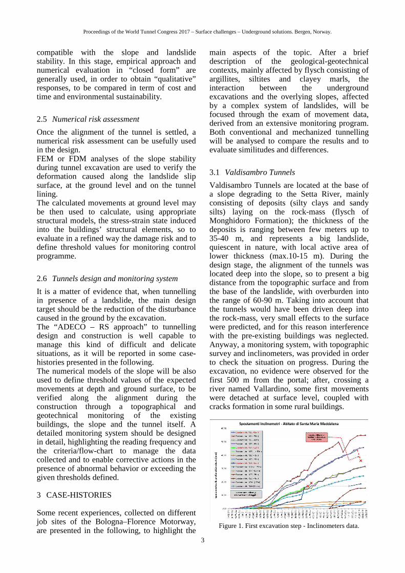
Valdisambro Tunnels are located at the base of a slope degrading to the Setta River, mainly consisting of deposits (silty clays and sandy silts) laying on the rock-mass (flysch of Monghidoro Formation); the thickness of the deposits is ranging between few meters up to 35-40 m, and represents a big landslide, quiescent in nature, with local active area of lower thickness (max.10-15 m). During the design stage, the alignment of the tunnels was located deep into the slope, so to present a big distance from the topographic surface and from the base of the landslide, with overburden into the range of 60-90 m. Taking into account that the tunnels would have been driven deep into the rock-mass, very small effects to the surface were predicted, and for this reason interference with the pre-existing buildings was neglected. Anyway, a monitoring system, with topographic survey and inclinometers, was provided in order to check the situation on progress. During the excavation, no evidence were observed for the first 500 m from the portal; after, crossing a river named Vallardino, some first movements were detached at surface level, coupled with cracks formation in some rural buildings.
Figure 1. First excavation step - Inclinometers data.
Proceedings of the World Tunnel Congress 2017 – Surface challenges – Underground solutions. Bergen, Norway.
4
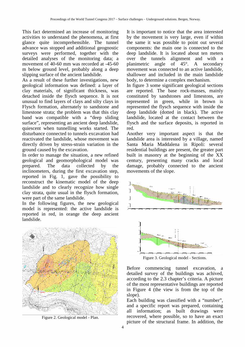
This fact determined an increase of monitoring activities to understand the phenomena, at first glance quite incomprehensible. The tunnel advance was stopped and additional geognostic surveys were performed, together with the detailed analyses of the monitoring data; a movement of 40-60 mm was recorded at -45-60 m below ground level, probably along a deep slipping surface of the ancient landslide. As a result of these further investigations, new geological information was defined: a layer of clay materials, of significant thickness, was detached inside the flysch sequence. It is not unusual to find layers of clays and silty clays in Flysch formation, alternately to sandstone and limestone strata; the problem was that this clay band was compatible with a “deep sliding surface”, representing an ancient deep landslide, quiescent when tunnelling works started. The disturbance connected to tunnels excavation had reactivated the landslide, whose movement was directly driven by stress-strain variation in the ground caused by the excavation. In order to manage the situation, a new refined geological and geomorphological model was prepared. The data collected by the inclinometers, during the first excavation step, reported in Fig. 1, gave the possibility to reconstruct the kinematic model of the deep landslide and to clearly recognize how single clay strata, quite usual in the flysch formation, were part of the same landslide. In the following figures, the new geological model is represented: the active landslide is reported in red, in orange the deep ancient landslide.
Figure 2. Geological model - Plan.
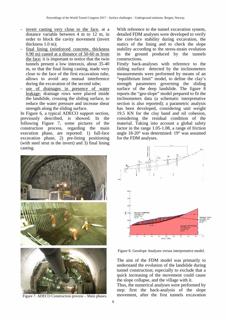
It is important to notice that the area interested by the movement is very large, even if within the same it was possible to point out several components: the main one is connected to the deep landslide. It is located about ten meters over the tunnels alignment and with a planimetric angle of 45°. A secondary movement was connected to an active landslide, shallower and included in the main landslide body, to determine a complex mechanism. In figure 3 some significant geological sections are reported. The base rock-masses, mainly constituted by sandstones and limestons, are represented in green, while in brown is represented the flysch sequence with inside the deep landslide (dotted in black). The active landslide, located at the contact between the flysch and the surface deposits, is reported in red. Another very important aspect is that the landslide area is interested by a village, named Santa Maria Maddalena in Ripoli: several residential buildings are present, the greater part built in masonry at the beginning of the XX century, presenting many cracks and local damage, probably connected to the ancient movements of the slope.
Figure 3. Geological model - Sections.
Before commencing tunnel excavation, a detailed survey of the buildings was achived, according to the 2.3 chapter’s criteria. A picture of the most representative buildings are reported in Figure 4 (the view is from the top of the slope). Each building was classified with a “number”, and a specific report was prepared, containing all information; as built drawings were recovered, where possible, so to have an exact picture of the structural frame. In addition, the

Proceedings of the World Tunnel Congress 2017 – Surface challenges – Underground solutions. Bergen, Norway.
5
AeDES sheet was compiled, to assess the damage level for each building. These sheets are generally defined after earthquake events, to understand the residual strength of the building taking into account its damage and cracks status; they were very useful to evaluate the damage level in progress, during tunnels excavation. An example of AeDES sheet is reported in Figure 5.
Figure 4. Santa Maria Maddalena view.
The new information about geological model and the data collected about interferences gave the possibility to redefine the design data and revalue the tunnel construction process. Once known the real geometry of the landslide, it was not possible to avoid interference with the tunnels constructions, so that it became very important to adopt a construction system able to minimize the impact with the pre-existances (the buildings and the slope itself!), minimizing the deformation inside the ground during exca-vation.
Figure 5. AeDES Sheet – Building n.10.
Before the tunnels excavation was stopped, conventional system was adopted, without face support, just confining the cavity by steel ribs and shotcrete. This system was upgraded, in the
spirit of ADECO Approach, according to Lunardi (2006). New pre-confinement and confinement actions were defined, in order to minimize face extrusion, convergence and settlements into the tunnel, which had reached 10-15 cm in the first stage of excavation. Several support sections were prepared according to the distance from the landslide surface, the landslide nature (active or deep landslide) and the face position with respect to the buildings location; specific “guidelines” were prepared too, in order to govern the support section application and to fine tuning the number of intervention.
Figure 6. ADECO Approach – Typical support section.
The main concepts included in the new support sections concern: - use of preconfinement interventions, ahead
of the face, by means of fiberglass elements located in the core-face (ranging between 60 to 120 pieces) and around the future excavation profile (outside the excavation profile the fiberglass elements, 30-60 in number, have been equipped by valves in order to inject cement mortar (30-60 lt/vlv) or expansive foam, in order to pre-stress the ground and create an artificial grouted arch, with protective function); the result is a significant reduction of the extrusion and pre-convergence at the face, got in addition to the stability of the core-face;
- full-face excavation (about 180 m2), able to rapidly close the cavity after each excavation step, by means of a pre-lining consisting of steel ribs and shotcrete, 25-30 cm thickness, located in the invert too (steel ribs and struts: 2IPE240 each 1.0 m). This steel strut, rigidly connected to the steel arch in crown, allows to contrast effectively the cavity convergence and to minimise settlement, working as preliminary foundation too;
Proceedings of the World Tunnel Congress 2017 – Surface challenges – Underground solutions. Bergen, Norway.
6
- invert casting very close to the face, at a distance variable between 4 m to 12 m, in order to block the cavity movement (invert thickness 1.0 m);
- final lining (reinforced concrete, thickness 0.90 m) casted at a distance of 50-60 m from the face; it is important to notice that the twin tunnels present a low interaxis, about 35-40 m, so that the final lining casting, made very close to the face of the first excavation tube, allows to avoid any mutual interference during the excavation of the second tube;
- use of drainages in presence of water leakage; drainage rows were placed inside the landslide, crossing the sliding surface, to reduce the water pressure and increase shear strength along the sliding surface.
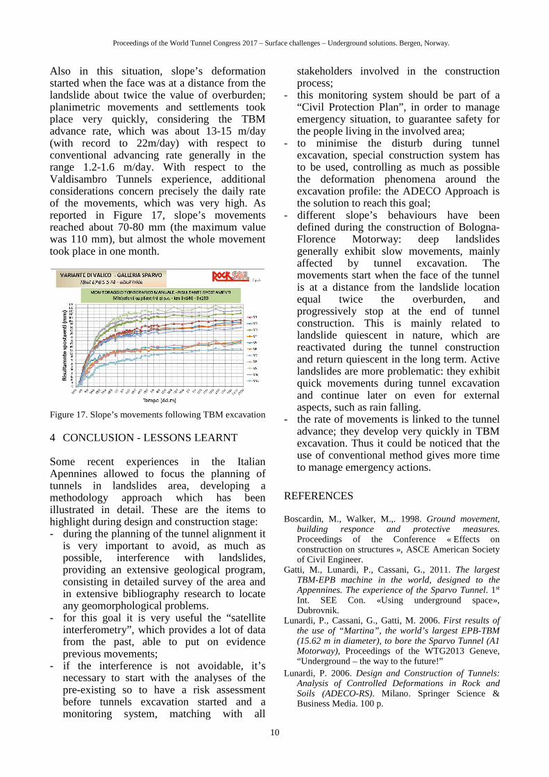
In Figure 6, a typical ADECO support section, previously described, is showed. In the following Figure 7, some pictures of the construction process, regarding the main execution phase, are reported: 1) full-face excavation phase, 2) pre-lining positioning (with steel strut in the invert) and 3) final lining casting.
Figure 7. ADECO Construction process – Main phases.
With reference to the tunnel excavation system, detailed FDM analyses were developed to verify the core-face stability during excavation, the statics of the lining and to check the slope stability according to the stress-strain evolution in the ground produced by the tunnels constructions. Firstly back-analyses with reference to the sliding surface detected by the inclinometers measurements were performed by means of an “equilibrium limit” model, to define the clay’s strength parameters governing the sliding surface of the deep landslide. The figure 8 reports the “geo-slope” model prepared to fit the inclinometers data (a schematic interpretative section is also reported); a parametric analysis has been developed, considering unit weight 19.5 KN for the clay band and nil cohesion, considering the residual condition of the material. Taking into account a global safety factor in the range 1.05-1.08, a range of friction angle 18-20° was determined: 19° was assumed for the FDM analyses.
Figure 8. Geoslope Analyses versus interpretative model.
The aim of the FDM model was primarily to understand the evolution of the landslide during tunnel construction; especially to exclude that a quick increasing of the movement could cause the slope collapse, and the village with it. Thus, the numerical analyses were performed by step: first the back-analysis of the slope movement, after the first tunnels excavation

Proceedings of the World Tunnel Congress 2017 – Surface challenges – Underground solutions. Bergen, Norway.
7
step, was reproduced. The tunnels deformation (convergence in the range of 80-100mm and settlement up to 120 mm), the landslide movements and the surface settlement (equal to 40-60 mm) were fitted to test the model reliability. In a second step, adopting the new excavation system, the tunnels construction was simulated to check the slope’s behavior. The results highlighted the stability conditions of the slope during excavation, predicting the entity of the movements: 60-100 mm along the landslide surface and in the range of 30-90 mm at the surface level, in corresponding of the Santa Maria Maddalena Village. In Figure 9 some images of the model are reported.
FLAC (Version 5.00)
LEGEND
19-Sep-11 16:02 step 92750 -4.593E+01 <x< 9.779E+02 -4.384E+02 <y< 5.855E+02
X-displacement contours -9.60E-02 -7.20E-02 -4.80E-02 -2.40E-02 0.00E+00 2.40E-02
Contour interval= 1.20E-02
-3.000
-1.000
1.000
3.000
5.000
(*10^2)
1.000 3.000 5.000 7.000 9.000(*10^2)
JOB TITLE : Spostamenti orizzontali
1 1
FLAC (Version 5.00)
LEGEND
7-Sep-11 16:05 step 100358 -2.048E+01 <x< 9.642E+02 -4.182E+02 <y< 5.665E+02
Y-displacement contours -6.30E-02 -4.50E-02 -2.70E-02 -9.00E-03 9.00E-03 2.70E-02
Contour interval= 9.00E-03
-3.500
-2.500
-1.500
-0.500
0.500
1.500
2.500
3.500
4.500
5.500(*10 2̂)
0.500 1.500 2.500 3.500 4.500 5.500 6.500 7.500 8.500 9.500(*10^2)
JOB TITLE : Spostamenti verticali
SPEA Ingegneria Europea spa
Figure 9. FDM Analyses – Model and movements results:
a) horizontal and b) vertical.
The FDM results confirmed the idea that the movements were slow, typical of ductile materials, such as clay, according to a strain-softening behavior in the residual stage, without quick increasing, most typical for elasto-fragile materials. The value of the predicted movements were considered as an “indication” of expected ones, useful to design the monitoring system and to define the attention and alarm thresholds for each components (in depth and at the ground level).
While these geotechnical analyses were performed, detailed analyses of the statical behavior of the buildings were performed too, sometimes applying 3D FEM models, to check the “today” situation and to predict the behavior of the buildings following the predicted slope’s movements. The safety and health of the people living in the area was the primary item of the working group, as well as environmental sustainability of the measures to be taken. In figure 10, an example of building analysis is illustrated; if the deformation imposed to the building’s structures, connected to the movement of the slope generated by the tunnels’ excavation, exceeded the strength of the materials, strengthening interventions were provided, such as steel rods or support elements in order to reach an adequate safety factor.
Figure 10. FEM for buildings: mesh and stress results.
A monitoring system was implemented for the buildings too, including topographic survey, able to evaluate building movements and distortion, and cracks survey (control of opening width and visual inspection). Attention and alarm value were defined according to the Boscardin and Walker abacus (1998), in which the vertical and horizontal distortions βw e βh are reported (see Figure 11). The “very slow damage” domain was used as attention value and the “moderate damage” as alarm value.

Proceedings of the World Tunnel Congress 2017 – Surface challenges – Underground solutions. Bergen, Norway.
8
Figure 11. Attention (green) and alarm (red) value for
buildings risk assessment.
All these data, derived from the monitoring system - both geotechnical related to the slope and structural related to the building, totally in real time - were managed according to strict procedures, as part of a “Civil Protection Plan” with emergency strategy. The project's uniqueness and the stakes required close attention by all operators (coordinated in a technical panel) and supervision by the relevant Authorities: firefighters and prefectural. The works were successfully completed and the tunnels are now under service. The collected monitoring data allow to drive some interesting remarks. The tunnels construction method was able to maintain the tunnel deformation very low, below the trigger limit; the core-face confinement minimized the extrusion phenomena (in general less than 10 mm) and the placing of the steel strut, combined with pre-lining and with the invert casted close to the face, maintained convergence and settlement below 50 mm (see Figure 12).
Figure 12. Tunnel monitoring data – Convergence.
The slope behavior, connected to the main deep landslide, at -40-60 m b.g.l., showed slow movements, due to the tunnels advance. As showed in Figure 13, the movements along the deep sliding surface reached the maximum
value of 140 mm. But this is a single case related to one inclinometer; the average value is 40-60 mm. It could be noticed a constant gradient until the tunnel face passed the position of the monitoring instrument; after some weeks (to take into account an inertial settling period) the gradient reduced up to became very small. We can conclude that the tunnel excavation functions as a “forcing”, which is a temporary disorder that gradually settles when the works are completed. After one year of concluded tunnels, just 1 mm/month is recorded (with respect to the 8-10 mm/month in the excavation period), in part connected to weather condition.
Figure 12. Deep landslide – Sliding surface movements.
The movement at the ground level reached 180-220 mm (maximum 340 mm), but they have been substantially uniform on a very large area, so that the gradients are very low, without significant distortion for building foundation. The whole village moved along with the slope without relevant damage for pre-existings.
Figure 14. Active landslide – Sliding surface movements.
Different behavior has been observed for the local area interested by the active landslide, fixed at -14 m below the ground level, at the deposits basement. The movements along the landslide surface are greater, reaching maximum value of 150-200 mm (the average value is about 110 m); part of these movements was

Proceedings of the World Tunnel Congress 2017 – Surface challenges – Underground solutions. Bergen, Norway.
9
caused by the interference with the tunnels excavation, but they present a cyclic behavior due to the seasonality. The rain falling is the most important parameter to govern the landslide behavior, so that a step-by-step increasing is connected to the worst atmospheric period, from January to March (rains and thawing). The figure 14 shows the trend of measurements, with an average increasing of 25-35 mm per year. Same consideration can be done for the surface movement; we note a big increasing of planimetric movements, after each winter period, while the settlement, generated by the tunnel excavation, is now stopped. Taking into account that the water circulation is the real cause of the phenomena, drainage shafts are planned to be executed, to control water and, consequently, the slope stability.
3.2 Sparvo Tunnels
Sparvo Tunnels were located in the opposite bank of the Setta River with respect to Valdisambro Tunnels; a bridge between the two tunnels crosses the river. But the slope of this bank is, at the same time, interested by several landslides, because of the poor condition of the ground, mainly represented by clays of the “Argillite a Palombini” formation, and considering the water level, which is very high. To face the tunnels excavation, a TBM-EPB was adopted; it was a very challenger project, considering the excavation diameter (15.56 m) and the TBM working parameters, such as thrust (up tp 390 MN) and chamber pressure (3.5-4.0 bar in crown, up to 7-8 bar at the base of the machine). The geotechnical dimensioning of the TBM and the construction process are described in Gatti et al. (2011) and Lunardi, Cassani and Gatti (2013).
Figure 15. Sparvo Tunnel. Axialsimmetric analysis to
define TBM excavation chamber pressure
With respect to the interference with the landslides located along the tunnels alignment,
similar criteria with Valdisambro Tunnels were used: the aim of the construction method was to minimize the deformation response after excavation, mainly maintaining the clays’ strength parameters closed to the peak value (elastic domain), neglecting, as much as possible, plasticization in the ground. Also this goal was achieved applying the ADECO Approach: several detailed analyses were performed to define the correct chamber pressure to properly confine the core-face, as illustrated in Figure 13. For the tunnel stretch under discussion, with overburden equal to 110-120 m, chamber pressure equal to 3.5 bar (at the top of the excavation chamber) was defined, to confine external ground pressure with low stress-strain redistribution. In this way, as assessed in Gatti (2011), it was possible to reduce the plasticization ring around the excavation profile, and consequently on one hand the friction forces on the TBM shield (“jamming risk control”) and on the other the propagation of the movements towards the ground surface. Anyway, it is important to highlight that jamming problem was the first item to address the TBM’s design; for this reason an high shield conicity was defined (from 35 mm to 70 mm at the tailshield), producing “ground loss volume”, during excavation, quite similar to a conventional construction technology.
Figure 16. FDM Model to study interference with the
landslide at Castagno Village
At the same time, FDM analyses of the slope were performed to consider the geometrical and geotechnical characteristics of the slope, taking into account the data collected by the inclinometers and the survey at the ground level. As showed in Figure 16, the location of the village, named Castagno, is not over the tunnel alignment, as in the case of Valdisambro Tunnels, and therefore settlement were lower than those affected the Santa Maria Maddalena Village, with lower risk for buildings and people involved.
Proceedings of the World Tunnel Congress 2017 – Surface challenges – Underground solutions. Bergen, Norway.
10
Also in this situation, slope’s deformation started when the face was at a distance from the landslide about twice the value of overburden; planimetric movements and settlements took place very quickly, considering the TBM advance rate, which was about 13-15 m/day (with record to 22m/day) with respect to conventional advancing rate generally in the range 1.2-1.6 m/day. With respect to the Valdisambro Tunnels experience, additional considerations concern precisely the daily rate of the movements, which was very high. As reported in Figure 17, slope’s movements reached about 70-80 mm (the maximum value was 110 mm), but almost the whole movement took place in one month.
Figure 17. Slope’s movements following TBM excavation
4 CONCLUSION - LESSONS LEARNT Some recent experiences in the Italian Apennines allowed to focus the planning of tunnels in landslides area, developing a methodology approach which has been illustrated in detail. These are the items to highlight during design and construction stage: - during the planning of the tunnel alignment it
is very important to avoid, as much as possible, interference with landslides, providing an extensive geological program, consisting in detailed survey of the area and in extensive bibliography research to locate any geomorphological problems.
- for this goal it is very useful the “satellite interferometry”, which provides a lot of data from the past, able to put on evidence previous movements;
- if the interference is not avoidable, it’s necessary to start with the analyses of the pre-existing so to have a risk assessment before tunnels excavation started and a monitoring system, matching with all
stakeholders involved in the construction process;
- this monitoring system should be part of a “Civil Protection Plan”, in order to manage emergency situation, to guarantee safety for the people living in the involved area;
- to minimise the disturb during tunnel excavation, special construction system has to be used, controlling as much as possible the deformation phenomena around the excavation profile: the ADECO Approach is the solution to reach this goal;
- different slope’s behaviours have been defined during the construction of Bologna-Florence Motorway: deep landslides generally exhibit slow movements, mainly affected by tunnel excavation. The movements start when the face of the tunnel is at a distance from the landslide location equal twice the overburden, and progressively stop at the end of tunnel construction. This is mainly related to landslide quiescent in nature, which are reactivated during the tunnel construction and return quiescent in the long term. Active landslides are more problematic: they exhibit quick movements during tunnel excavation and continue later on even for external aspects, such as rain falling.
- the rate of movements is linked to the tunnel advance; they develop very quickly in TBM excavation. Thus it could be noticed that the use of conventional method gives more time to manage emergency actions.
REFERENCES
Boscardin, M., Walker, M.,. 1998. Ground movement, building responce and protective measures. Proceedings of the Conference « Effects on construction on structures », ASCE American Society of Civil Engineer.
Gatti, M., Lunardi, P., Cassani, G., 2011. The largest TBM-EPB machine in the world, designed to the Appennines. The experience of the Sparvo Tunnel. 1st Int. SEE Con. «Using underground space», Dubrovnik.
Lunardi, P., Cassani, G., Gatti, M. 2006. First results of the use of “Martina”, the world’s largest EPB-TBM (15.62 m in diameter), to bore the Sparvo Tunnel (A1 Motorway), Proceedings of the WTG2013 Geneve, “Underground – the way to the future!”
Lunardi, P. 2006. Design and Construction of Tunnels: Analysis of Controlled Deformations in Rock and Soils (ADECO-RS). Milano. Springer Science & Business Media. 100 p.