Planning Commission - Staff Report · Planning Commission - Staff Report Meeting Date: August 27,...
114
ITEM #: 5b SECTION: Unfinished Business Planning Commission - Staff Report Meeting Date: August 27, 2013 From: Bob Borchard Action Title: Blueprint Principles Implementation in Waterford EXECUTIVE SUMMARY: The purpose of this discussion is to review the Blueprint Implementation Report prepared for the City under the Proposition 84 Planning Grant. The report is a compilation of City adopted policies and standards that implement the twelve Valley Blueprint Principles. RECOMMENDATION / ANALYSIS: It is Staff’s recommendation that the Planning Commission members review the attached Blueprint Implementation Matrix report and discuss the individual implementation/integration measures. The report complies with the Valley Blueprint final report by documenting the implementation Valley Blueprint implementation strategy adopted by the City of Waterford. FISCAL IMPACT: This Project is undertaken with funds that were awarded to the City through the California Department of Housing and Community Development Sustainable Communities Planning Grants Program as administered by the California Department of Conservation, Division of Land Resources Protection. The long term fiscal commitments, by the City, are not expected to exceed present day commitments in the implementation of the City’s General Plan or administration of its Codes and regulations. BACKGROUND: The City of Waterford, under the Prop. 84 Grant award to Stanislaus County and its eight cities has three projects. The first, the Waterford Urban Forest Plan, has been adopted by the Waterford City Council. The second project, the Valley Blueprint Implementation Matrix, is an effort to identify a strategy for the City of Waterford to implement the San Joaquin Valley Blueprint. The third project is an Update of Waterford’s CEQA Policies and Procedures with respect to implementation of the requirements of SB 375. The Blueprint Implementation Matrix is based on the twelve Valley Blueprint Principals. (See Valley Blueprint Background Information attachment). The attached Blueprint Integration Survey document contains a list of “implementation” or “integration” measures that have been identified as approaches that can be taken by a City to achieve implementation or integration of the Blueprint Principals into a City’s planning and community development program.
Transcript of Planning Commission - Staff Report · Planning Commission - Staff Report Meeting Date: August 27,...

ITEM #: 5b SECTION: Unfinished Business
Planning Commission - Staff Report
Meeting Date: August 27, 2013
From: Bob Borchard
Action Title: Blueprint Principles Implementation in Waterford
EXECUTIVE SUMMARY:
The purpose of this discussion is to review the Blueprint Implementation Report prepared for the City under the Proposition 84 Planning Grant. The report is a compilation of City adopted policies and standards that implement the twelve Valley Blueprint Principles.
RECOMMENDATION / ANALYSIS:
It is Staff’s recommendation that the Planning Commission members review the attached Blueprint Implementation Matrix report and discuss the individual implementation/integration measures. The report complies with the Valley Blueprint final report by documenting the implementation Valley Blueprint implementation strategy adopted by the City of Waterford.
FISCAL IMPACT:
This Project is undertaken with funds that were awarded to the City through the California Department of Housing and Community Development Sustainable Communities Planning Grants Program as administered by the California Department of Conservation, Division of Land Resources Protection. The long term fiscal commitments, by the City, are not expected to exceed present day commitments in the implementation of the City’s General Plan or administration of its Codes and regulations.
BACKGROUND: The City of Waterford, under the Prop. 84 Grant award to Stanislaus County and its eight cities has three projects. The first, the Waterford Urban Forest Plan, has been adopted by the Waterford City Council. The second project, the Valley Blueprint Implementation Matrix, is an effort to identify a strategy for the City of Waterford to implement the San Joaquin Valley Blueprint. The third project is an Update of Waterford’s CEQA Policies and Procedures with respect to implementation of the requirements of SB 375. The Blueprint Implementation Matrix is based on the twelve Valley Blueprint Principals. (See Valley Blueprint Background Information attachment). The attached Blueprint Integration Survey document contains a list of “implementation” or “integration” measures that have been identified as approaches that can be taken by a City to achieve implementation or integration of the Blueprint Principals into a City’s planning and community development program.

Page 2
The introduction to the report provides some background on the development of the City of Waterford’s General Plan and the underlying principles that are guiding the planning policies set forth in the General Plan. Since the City began its General Plan Update nearly ten years ago, back in 2003, there has been a great deal of development in city planning theory. The California (and National) League of Cities have established “Smart Growth” as the basic standard that our cities should be working towards.
There are 10 accepted principles that define smart growth:
1. Mix land uses 2. Take advantage of compact building design 3. Create a range of housing opportunities and choices 4. Create walkable neighborhoods 5. Foster distinctive, attractive communities with a strong sense of place 6. Preserve open space, farmland, natural beauty, and critical environmental areas 7. Strengthen and direct development towards existing communities 8. Provide a variety of transportation choices 9. Make development decisions predictable, fair, and cost effective 10. Encourage community and stakeholder collaboration in development decisions
Transportation and community planners began to promote the idea of compact cities and communities in the early 1970s. The cost and difficulty of acquiring land (particularly in historic and/or areas designated as conservancies) to build and widen highways caused some elected officials to reconsider basing transportation planning on motor vehicles. Architect Peter Calthorpe promoted and popularized the idea of urban villages that relied on public transportation, bicycling, and walking instead of automobile use. Architect Andrés Duany promoted changing design codes to promote a sense of community, and to discourage driving. Colin Buchanan and Stephen Plowden helped to lead the debate in the United Kingdom. The work of Peter Calthorpe in the City of Merced played a major role in the formulation of the City of Waterford’s plan. As discussed in the attached report, the ten “Smart Growth” principles have been adapted to the Valley with Blueprint project in the formulation of twelve “Blueprint Principles:
1. Mix Land Uses 2. Take Advantage Of Compact Building Design 3. Create A Range Of Housing Opportunities And Choices 4. Create Walkable Neighborhoods 5. Foster distinctive, attractive communities with a strong sense of place 6. Preserve Open Space, Farmland, Natural Beauty, Critical Environmental Areas 7. Strengthen And Direct Development Towards Existing Communities 8. Provide a Variety Of Transportation Choices 9. Make Development Decisions Predictable, Fair, And Cost-Effective
10. Encourage Community and Stakeholder Collaboration
11. Support Actions That Encourage Environmental Resource Management (Valley Addition) 12. Enhance the Economic Vitality Of The Region (Valley Addition)
ATTACHMENTS: • City of Waterford Implementation of the 12 Valley Blueprint Principles

Page 3
City of Waterford Valley Blueprint
12 “ Smart Growth” Principles Implementation Matrix
A Stanislaus County Toolkit Tool This Plan was prepared with funds provided by the California Department of Housing and Community Development from the Proposition 84 Funds through the Sustainable Community Program of the Sustainable Communities Planning Grants Program administered by the California Department of Conservation, Division of Land Resource Protection.

Page 4

Page 5
Valley Blueprint 12 “ Smart Growth” Principles Implementation
In the City of Waterford
Prepared under the Auspices of the Stanislaus County Tool-Kit Project
Prepared by
Robert L. Borchard City of Waterford
Municipal Planning Services
August 2013

Page 6
TABLE OF CONTENTS Page No. Executive Summary…………………………………………………………………….. 4 Purpose……………………………………………………………………………….. 4 Background……………………………………………………………………………….. 4 Overview……………………………………………………………………………….. 4 Legislative Setting…………………………………………………………………….. 5 AB 32……………………………………………………………………………….. 5 SB 375……………………………………………………………………………….. 5 The Urban Planning Setting…………………………………………………………….. 6 Waterford’s Planning Roots………………………………………………………….. 6 Waterford’s “Smart Growth” Implementation………………………………………….. 6 Stanislaus County Vision Statement ………………………………………………….. 10 The Blueprint Planning Process…………………………………………………….. 11 Valley Blueprint Planning………………………………………………………….. 11 StanCOG & the Valley Blueprint Planning Process………………………………….. 12 Density and Blueprint Planning…………………………………………………….. 15 Blueprint “Smart Growth” Principles……………………………………………….. 17 Sustainable Communities Planning………………………………………………….. 18 Applicability………………………………………………………………………….. 20 Attachments…………………………………………………………………………….. 20
Attachment 1. City of Waterford Implementation Matrix of the Blue Print Principles. ………………………………………………… 22
Attachment 2. City of Waterford Valley Blueprint “Smart Growth” Principles
Implementation. …………………………………………………. 34

Page 7
Valley Blueprint Principal Implementation In the City of Waterford
EXECUTIVE SUMMARY:
This report provides a summary of the policies and standards adopted by the City of Waterford that implement the twelve Valley Blueprint Principles. Included in this report Tables 1 and 2 as follows: Table 1 Contains a Matrix that summarizes City policy and standards that have been adopted by the City that implement the 12 Blueprint “Smart Growth” Principles. This Table also shows the interrelated nature of various implementation efforts of the City with respect to other Blueprint “Smart Growth” Principles. The Table cross references specific “Smart Growth” Principal actions with other Principles as to how they Directly (D) or Indirectly (I) or have no direct relationship to the various Blueprint Principles. The second Table 2, contains a more detailed description of the implementation measures taken by the City, as categorized by Principal and Implementation “group” characterization. This report also provides some background on the development of planning policy in the City of Waterford and the relationship between the City’s application of the Ahwahnee Principles, as well as the planning concepts known as “New Urbanism”, “Smart Growth”, “Sustainable Planning”, etc. These “planning Principles” all form the basis for guiding the development of city planning in the State of California and have become “mandated”, to some degree, through the adoption of AB 32 and SB 375. These two State laws form the basis for the current Regional Transportation Plan-Sustainable Communities (Valley Vision Stanislaus) process administered by the Stanislaus County Council of Governments (StanCOG).
PURPOSE:
The purpose of this report is to provide background information on the planning process in the City of Waterford and document the City’s implementation of the 12 Valley Blueprint “Smart Growth” Principles. It should be noted that the planning process in Waterford, like any city in the State of California, is a dynamic process subject to changes in the law, municipal circumstance and the “direction” that the residents of the City of Waterford choose to take in response to these future changes.
BACKGROUND:
Overview Currently the City of Waterford, like all cities in Stanislaus County and the County itself, are engaged in a new planning process mandated by the State of California. The key planning objective of these planning laws is to reduce Greenhouse Gas (GHG) emissions in the state. The problems, resulting from excess GHG are identified as the chief culprit in our changing climate. Climate change is projected to create major problems by disrupting rainfall and snowfall patterns and water supply, changing agricultural crop patterns, etc.

Page 8
The chief ingredient in GHG pollution is Carbon. The burning of fossil (oil & gas) creates excess carbon dioxide in the atmosphere which has been directly linked to our changing climate. The key elements in the new State laws are programs and strategies to reduce GHG emissions. The key causes of GHG have been found to be from automobile and truck exhaust along with “excess” use of utilities for heating and cooling that has increased demand for fossil fuel electrical generating capacity. State laws (AB 32 and SB 375) create mandates for local governments to develop plans and strategies to make our communities “sustainable” over time. In a city planning context, sustainability has had different meanings over the history of our civilization and settlement patterns and has resulted in the development of modern concepts of water and wastewater treatment, transportation and circulation planning and design, etc. In the context of GHG pollution, sustainability has focused on how we consume non-renewable resources. Legislative Setting Assembly Bill 32 (AB 32) AB 32, the Global Warming Solutions Act, was passed by the California state legislature on August 31, 2006, to place the state on a course toward reducing its contribution of GHG emissions. AB 32 requires the state’s global warming emissions to be reduced to 1990 levels by the year 2020. It is projected that GHG emissions in California by 2020 will be approximately 596 million metric tons (M MT ns ). (California Air Resources Board [CARB] 2008). In December 2007, CARB approved a 2020 emissions limit of 427 MM Tons of CO 2e (471 MM tons) for the state. The 2020 target requires emissions reductions of 169 MM Tons, 28.5 percent of the projected emissions compared to business-as-usual (BAU) in year 2020 (i.e., 28.5 percent of 596 MM Tons) (CARB 2008). Since release of the 2008 Scoping Plan, CARB has updated the statewide GHG emissions inventory to reflect GHG emissions in light of the economic downturn and measures not previously considered within the 2008 Scoping Plan baseline inventory. The updated forecast predicts emissions to be 507 MM Tons by 2020. The new inventory identifies that an estimated 80 MM Tons of reductions are necessary to achieve the statewide emissions reduction of AB 32 by 2020, 15.7 percent of the projected emissions compared to BAU in year 2020 (i.e., 15.7 percent of 507 MM Tons). Senate Bill 375 (SB 375) In 2008, SB 375 was adopted to connect the GHG emissions reductions targets established in CARB’s Scoping Plan for the transportation sector to local land use decisions that affect travel behavior. Its intent is to reduce GHG emissions from light-duty trucks and automobiles (excludes emissions associated with goods movement) by aligning regional long-range transportation plans, investments, and housing allocations to local land use planning to reduce vehicle miles traveled and vehicle trips. Specifically, SB 375 requires CARB to establish GHG emissions reduction targets for each of the 18 regions in California managed by a metropolitan planning organization (MPO). StanCOG is the MPO for the Stanislaus County.
Page 9
SB 375 also requires the MPOs to prepare a Sustainable Communities Strategy (SCS) in their regional transportation plan. Because use of the term “sustainable” has become politically un-fashionable, most planning agencies in the Valley have renamed the SCS planning process the “Valley Vision” planning process. It should be noted, however, the “Valley Vision Stanislaus” plan is being formulated to meet the SCS requirements of SB 375, and includes the combined efforts of the 2014 Regional Transportation Plan, and the Regional Housing Needs Assessment. The Valley Vision Stanislaus plan is the combined effort of the 2014 RTP, SCS and the RHNA according to StanCOG Staff.
THE URBAN PLANNING SETTING:
Waterford’s Planning Roots The City of Waterford, incorporated in 1969, endured some difficult times in its early formative years. The City, at one point in time, was facing bankruptcy. The City’s first General Plan was developed by a consulting firm around model language from similar small towns in the region. Its development codes were “borrowed” from other cities of similar size and circumstance. In 2003, having gotten its financial house in order, the City launched a program to update its General Plan and development codes. The formulation of the Waterford Plan was heavily influenced by the work of a “New Urbanist” planner named Peter Calthorpe who had developed a series of plans and studies for the City of Merced. The concepts of “New Urbanism”, “Urban Sustainability”, “Smart Growth”, etc., were integrated into the City’s new General Plan goals and policies. The City’s Plan, included a “optional” General Plan Element titled “Sustainable Development” where the Principles and policies of Waterford’s environmental conservation (air, water, soil, etc.) policies and standards were articulated. In broad planning terms, in the context of the Waterford Vision 2025 Plan, “Sustainable” means meeting the needs of the present without compromising the ability of future generations to meet their needs. In practical terms, sustainable growth in the City of Waterford means accommodating growth and development without unnecessarily:
• Consuming our valuable and limited agricultural soils, • Contaminating or over-taxing our water supplies, • Destroying or diminishing the value of important wildlife habitat, • Reducing our air quality to a point where our quality of life is threatened, • Consuming limited non-renewable energy resources, or • Destroying our cultural and historic resources.

Page 10
As a result of the City’s planning focus on “New Urbanism”, “Smart Growth” and concepts of “sustainability”, the City’s General Plan and development policies anticipated many of the rules and regulations passed down in State law such as AB 70 regarding climate and air quality and AB32/SB375 with respect to reduction of Greenhouse Gasses. At the same time, the City’s foresight anticipated for other new State Planning Laws such as California Complete Streets Act of 2008 (AB 1358). Waterford’s “ Smart Growth” Implementation The “Smart Growth” Principles that have been articulated in the Waterford Vision 2025 General Plan are based on the Ahwahnee Principles. The Ahwahnee Principles are named after the meeting place, in Yosemite Valley (not far from Waterford) where a group of visionary planners first presented their ideas to a group of state and local government city planners. The California Local Government Commission brought together a group of architects who have been leaders in developing new notions of land use planning: Andres Duany and Elizabeth Plater-Zyberk, Stefanos Polyzoides and Elizabeth Moule, Peter Calthorpe, and Michael Corbett. These innovators were asked to come to agreement about what it is that the new planning ideas - from neotraditional planning to sustainable design- have in common and from there, to develop a set of community principles. A Local Government Commission staff-member Peter Katz, author of the New Urbanism, organized the meeting. This group of urban planning and design leaders asked how each community should relate to the region, and to develop a set of regional principles. They were also charged with defining how these ideas might be implemented by cities and counties. The architects' ideas were drafted by attorney Steve Weissman into a form which would be useful to local elected officials and provide a vision for an alternative to urban sprawl. A preamble, topics of specific ideas, community principles, regional principles and implementation of the principles was presented in the fall of 1991 to about 100 local elected officials at a conference at the Ahwahnee Hotel in Yosemite. There they received both a highly enthusiastic response and their title- the Ahwahnee Principles. The Ahwahnee Principles have been integrated into several planning concepts generally classified as “neo-traditional” urban planning or the “New Urbanist” concept that emphasizes mixed use development and non-vehicular transportation networks.
Ahwahnee Community Principles 1. All planning should be in the form of complete and integrated communities containing
housing, shops, work places, schools, parks and civic facilities essential to the daily life of the residents.
2. Community size should be designed so that housing, jobs, daily needs and other activities are within easy walking distance of each other.
3. As many activities as possible should be located within easy walking distance of transit stops.

Page 11
4. A community should contain a diversity of housing types to enable citizens from a wide range of economic levels and age groups to live within its boundaries.
5. Businesses within the community should provide a range of job types for the community’s residents.
6. The location and character of the community should be consistent with a larger transit network.
7. The community should have a center focus that combines commercial, civic, cultural and recreational uses.
8. The community should contain an ample supply of specialized open space in the form of squares, greens and parks whose frequent use is encouraged through placement and design.
9. Public spaces should be designed to encourage the attention and presence of people at all hours of the day and night.
10. Each community or cluster of communities should have a well-defined edge, such as agricultural greenbelts or wildlife corridors, permanently protected from development.
11. Streets, pedestrian paths and bike paths should contribute to a system of fully-connected and interesting routes to all destinations. Their design should encourage pedestrian and bicycle use by being small and spatially defined by buildings, trees and lighting; and by discouraging high speed traffic.
12. Wherever possible, the natural terrain, drainage, and vegetation of the community should be preserved with superior examples contained within parks or greenbelts.
13. The community design should help conserve resources and minimize waste. 14. Communities should provide for the efficient use of water through the use of natural
drainage, drought tolerant landscaping and recycling. 15. The street orientation, the placement of buildings and the use of shading should contribute to
the energy efficiency of the community.
Ahwahnee Regional Principles 1. The regional land use planning structure should be integrated within a larger transportation
network built around transit rather than freeways. 2. Regions should be bounded by and provide a continuous system of greenbelt/wildlife corridors
to be determined by natural conditions. 3. Regional institutions and services (government, stadiums, museums, etc.) should be located in
the urban core. 4. Materials and methods of construction should be specific to the region, exhibiting continuity
of history and culture and compatibility with the climate to encourage the development of local character and community identity.
The Ahwahnee Principles and “neo-traditional” planning concepts have been implemented in the City of Waterford’s Vision 2025 General Plan by following the following guiding principles: • Conserve natural resource areas that give form and character to the community. In Waterford, the landscape setting, perhaps more than any other factor, affects the physical

Page 12
character of the community. The policies contained in the Open Space, Conservation & Recreation Chapter, as well as others, provide for strengthening the visual and physical connection between the city and its natural elements. The Urban Expansion Chapter guides future city growth away from important resource areas.
• Promote an urban form that integrates housing, shops, work places, schools, parks and civic facilities. The development approach set forth in the Land Use Chapter and the Land Use Diagram of this Plan, is the primary means of implementing this design principal. • Within this land use pattern, private and public development is guided by the principles contained in this Chapter. • Reinforce the elements of the community which give Waterford its unique identity. Through purposeful acts of community building at the city’s inception, Waterford developed into a thriving and attractive community. The design and development concepts outlined in this Chapter expands on these successful early planning efforts to assure that future growth and development retains Waterford’s unique character. • Expand the city’s non-vehicular transportation network. Through provisions contained in the Transportation & Circulation Chapter and supporting policies of other chapters of this Plan, the City’s system of bike and pedestrian paths will expand to serve new growth and development. This pedestrian network is an integral part of the successful implementation of the City’s design concept. • Promote pedestrian access to work, commercial, recreation and residential places. The success of the neo-traditional development approach relies on private development which is pedestrian friendly. The Urban Design Chapter proposes various design approaches which will improve access and encourage walking and bicycling as a viable transportation alternative at the project level and community-wide. • Reinforce the downtown as the heart of the city. Downtown Waterford plays an important role in the social and economic well-being of the community. It is the historical identity of the City and is the direct access point to regional highway network. Policies contained in the various chapters of this plan strengthen the role and function of Waterford’s downtown area. • Conserve the special qualities of existing neighborhoods and districts. The distinctive character of Waterford’s older residential neighborhoods downtown district are the basis of memorable features in the community. The Land Use and Urban Design Chapters of this plan provide policies and guidance for maintaining these qualities. The policies and design proposals of the Urban Design Chapter provide a basis for developing these qualities in new and expanded neighborhoods.
• Focus residential, commercial and employment center development to encourage public transit use. Successful urban centers of the future will be designed to accommodate local and regional public transportation and communication systems. Although at present population levels, public transit cannot be extensively implemented in a cost effective manner, future

Page 13
population levels, coupled with changing technology will make public transit a more viable option. Urban design policies, which facilitate transit friendly development, are contained in the Land Use, Transportation, and Urban Design Chapters of the City of Waterford Vision 2025 General Plan.
• Maximize the use of city streets as public spaces. The streets of Waterford contribute to the public open spaces of the city and can be among its liveliest and most memorable public spaces. Design considerations which focus on accommodating the automobile to the exclusion of all other activities and modes of transportation can diminish the public value of the city’s street system. Policies contained in the Transportation & Circulation Chapter along with the design concepts developed in the Urban Design Chapter of this Plan, are aimed at balancing the need for auto movement and parking with the need for the street system to accommodate other vital community needs. It is the primary purpose of this Plan to move the City of Waterford towards a better future state while preserving the quality of life that is part of living in a small rural town on the eastside of the Central San Joaquin Valley. The Waterford Vision 2025 General Plan is the City’s primary planning tool for guiding a growing community towards actions that preserves much of its small town flavor and social setting. A city that has an improved economy, adequate public services and cultural facilities, and a good overall quality of life for its residents. The result of Waterford’s vision for the City is that in 2025 and beyond: • People will be able to enjoy other forms of transportation. • Parks and open spaces will link residential, commercial, and employment centers in such a
manner as to provide an attractive pedestrian or non-vehicular alternative to driving. • The community will have a vital economy that minimizes the need for residents to travel to
other communities in the region for employment, goods and services. • The City will provide cost effective public services and that residents will enjoy parks,
playgrounds and cultural facilities similar to that of other communities in the region. • The City of Waterford will retain its small rural community charm while continuing to serve
a strong regional farm and recreation economy. Stanislaus County Vision Statement Over the course of several years, leaders of government, business and industry throughout Stanislaus County met in an effort to define and adopt a “Vision” statement for Stanislaus County. That statement is as follows:
Land Use

Page 14
VISION: We will demonstrate our resolve to produce a world class example of “DOING IT RIGHT” so that Stanislaus County remains blessed with a bounty of fertile land for agriculture. Population growth will be accommodated in communities of varying sizes ranging from larger metropolitan areas to mid-sized cities, to small rural towns and enclaves. Communities will plan, grow and evolve in a compact, efficient fashion. Large expanses of agricultural land and other open space will secure buffers between urban areas and preserve the beauty of views and vistas throughout the County. Transportation VISION: We will have an efficient, integrated transportation system that provides internal and external linkages and facilitates economic growth. Education VISION: Everyone, especially our children, will have opportunities to stimulate the mind, inspire the spirit and develop healthy bodies. Community VISION: Stanislaus County will contain diverse, interesting and unique social and cultural characteristics that strengthen the bonds within and between our communities, preserve local identity and enhance regional pride. Individuals and groups will commit to contributing to the well being of their community. Government VISION: Our local governments will govern based on the principle of stewardship. Elected officials and government employees will hold public resources and processes in trust for citizens and they will act in service of citizens and the community, not in self-interest.

Page 15
Public Safety VISION: Recognizing that public safety is the foundation for a safe and healthy society, law enforcement, fire and life safety service agencies will provide Stanislaus County residents with the highest quality services possible in conjunction with local community involvement. To that end, all agencies will strive to collaborate and form partnerships to deliver optimum service in all aspects of public safety.
The City of Waterford’s General Plan Vision, as organized around the Ahwahnee Principles, implemented this Stanislaus County-Wide Vision in a manner that fit the unique setting and circumstances of the City of Waterford.
THE BLUEPRINT PLANNING PROCESS:
Valley Blueprint Planning The Valley Blueprint was developed by the eight Regional Transportation Planning Agencies representing the eight counties within the San Joaquin Valley in 2006. The San Joaquin Valley Blueprint process began in 2006. Merced COG, in coordination with the Great Valley Center, led the Valley wide Blueprint effort on behalf of the San Joaquin Valley organizations. Seven Valley COGs and one RTPA participated in the Valley Blueprint: the Council of Fresno County Governments (Fresno COG), the Kern Council of Governments (Kern COG), the Kings County Association of Governments (KCAG), the Madera County Transportation Commission (MCTC), the Merced County Association of Governments (MCAG), the San Joaquin Council of Governments (SJCOG), the Stanislaus Council of Governments (Stan COG), and the Tulare County Association of Governments (TCAG). Throughout this report these eight organizations are referred to collectively as the Valley COGs. With funding from the California Regional Blueprint Planning Program, the eight Valley COGs prepared separate countywide blueprints, which were then consolidated into a single Valley wide Blueprint. The process included three major phases: 1) Values and Vision; 2) Goals, Objectives, and Performance Measures; and 3) Evaluation of Alternative Growth Scenarios. On April 1, 2009, San Joaquin Valley Regional Policy Council, the decision-making body for the Valley-wide process, approved Scenario B+ and 12 Smart Growth Principles, concluding the San Joaquin Valley Blueprint planning process. The Valley Blueprint is a vision for the future of the San Joaquin Valley, in which less land is consumed for development, more resources are preserved for future generations, distinctive communities are enhanced, and more travel choices are available. In the next 40 years, the San Joaquin Valley it is expected that we will more than double in population from 3.3 million to more than 7 million. But with growth comes challenges.
• Where will the roads go? • What type of housing should be built and where? • How will this growth affect our environment?

Page 16
The Councils of Government from each of the San Joaquin Valley's counties jointly applied for a grant to begin the Blueprint implementation effort. The motivation for the project was to determine if there are alternatives to current transportation investment priorities that would make improvements to the region's travel patterns and air quality, while being consistent with local attitudes and values. Funding for the Blueprint planning effort was provided by grants received from the California Department of Business, Transportation and Housing and the San Joaquin Valley Air Pollution Control District. Additional information regarding the Valley Blueprint project can be found at:
The San Joaquin Valley Blueprint Background (from the Valley Blueprint Website http://www.valleyblueprint.org/) .
StanCOG & the Valley Blueprint Planning Process StanCOG represents 10 member agencies including Stanislaus County and the cities of Ceres, Hughson, Modesto, Newman, Oakdale, Patterson, Riverbank, Turlock, and Waterford. StanCOG is governed by a 16-member Policy Board which includes the five county supervisors and elected-officials from each city The Stanislaus Council of Governments (StanCOG), was responsible for coordinating the Blueprint planning process within Stanislaus County. As the federally-mandated Metropolitan Planning Organization (MPO) and state-designated Regional Transportation Planning Agency (RTPA) for the Stanislaus County region, StanCOG is prescribed by law to have lead responsibility for the development of the region's transportation plans and to coordinate the transportation planning process. To effectively plan for and manage a multi-modal transportation system, StanCOG prepares, oversees or manages the following plans and processes. Regional Transportation Plan The Regional Transportation Plan (RTP) is the region's blueprint for future transportation improvements and investments based on specific transportation goals and objectives defined by StanCOG, the public and its elected officials. 2014 Valley Vision Stanislaus Valley Vision Stanislaus is a long range planning document that will provide the framework for investment in roads, freeways, public transit like buses, bike trails and other ways people move around our County for the next 28 years. It will also include a plan to accommodate the region's future housing needs and help us comply with new State-mandated legislation to reduce greenhouse gases (as required by SB 375) Regional Housing Needs Allocation (RHNA) The Regional Housing Needs Allocation process identifies the State of California’s future housing needs throughout the State. StanCOG, as the Regional Planning Agency, is charged with distributing the fair-share housing need allocation to each agency within the region based primarily on population.

Page 17
Non-Motorized Transportation Plan The Non-Motorized Transportation Plan is intended to guide efforts to improve bicycling and walking conditions at the local level. The Plan is one of many steps being taken to provide for alternative modes of travel and to address traffic congestion in the region by developing an efficient and coordinated multi-modal transportation system. Blueprint The Blueprint process is designed to create tools to help the region plan for future growth into more sustainable communities through the integration of transportation, housing, land use, economic development and environmental protection. Regional Express Study In 1990, to attempt to alleviate the traffic congestion from growth, StanCOG, in cooperation with the 10 local agencies, developed a Regional Expressway Study to identify, fund and construct many of the expressways we drive on today. In 2010, StanCOG adopted an update to this plan to identify completed projects, changes to population projects and updates to the local agencies general plans. High Speed Rail California's electrically-powered high-speed trains will help the state meet ever-growing demands on its transportation infrastructure. High-speed trains will travel between LA and San Francisco, through the Valley, in under 3 hours, at speeds of up to 220 mph, and will interconnect with other transportation alternatives, providing an environmentally friendly option to traveling by plane or car. Air Quality The Federal Clean Air Act requires that each planning and programming document (i.e. RTP and Federal Transportation Improvement Program, FTIP) prepared by StanCOG conform to the state level air quality standard plan, called the State Implementation Plan (SIP). StanCOG is in charge of preparing Conformity Analyses as part of the development of the RTP and FTIP. Congestion Management Process (CMP) The StanCOG Congestion Management Process (CMP) is an integrated component of StanCOG's planning process, which provides a systematic progression of activities to analyze and address regional traffic congestion. The CMP is then integrated into the Regional Transportation Plan (RTP) and Federal Transportation Improvement Program (FTIP) processes to ensure critical congestion information is addressed. Environmental Justice Analysis In 1994, Executive Order 12898 was signed requiring that each federal agency or agency receiving federal dollars shall, to the greatest extent allowed by law, administer and implement its programs, policies, and activities that affect human health or the environment so as to avoid ‘disproportionately high and adverse’ effects on minority and low-income populations.

Page 18
Vision Statement and Guiding Principles Based on public input, StanCOG developed a vision statement and guiding principles to guide the direction of the COG Blueprint. In the future Stanislaus County will have a superior quality of life, prosperity, equality, and economic opportunity for future generations. To achieve this vision, StanCOG developed guiding principles organized around topics including: community, environment, land use, economy, transportation, education, government, and public safety. Outreach Over the two phases of the StanCOG Blueprint planning process, StanCOG conducted 28 workshops attended by over 690 local residents. StanCOG conducted three workshops for the Spanish-speaking population in various parts of the county. During Phase 1 StanCOG staff conducted 14 vision and values workshops (including one in Spanish), in which 440 Stanislaus residents participated. The workshops gave residents the opportunity to develop guiding principles for the future of the county and its cities. StanCOG staff developed a summary of the vision statement and guiding principles following these workshops. Valley Preferred Growth Scenario The StanCOG Board selected the “Moderate Change” B+ growth scenario as the preferred Blueprint growth scenario. The Moderate Change growth scenario received the highest number of votes during Phase 2 workshops because it best represents the principles of smart growth promoted during the Blueprint planning process. Compared to the status quo growth scenario, the preferred scenario increases medium- and high-density housing from nine percent to 27 percent of all new residential development and creates greater local and regional transit opportunities. The preferred scenario prioritizes protection of environmental resources and agricultural land, and emphasizes compact growth within existing communities. The preferred growth scenario also illustrates regional transportation infrastructure to connect the Valley. The preferred growth scenario will serve as a guideline for Valley cities and counties as they update their general plans. The preferred growth scenario envisions increased densities (i.e., dwelling units per gross acre) in all of the eight valley counties. Where current average densities range from 3.8 to 4.8 dwelling units per acre, in the preferred growth scenario average densities range from 4.7 to 8.6 dwelling units per acre.

Page 19
COMPARING AVERAGE
DENSITY
COUNTY
Current Trends
Preferred Growth Scenario
FRESNO 3.8 8.0 KERN 3.9 6.0 KINGS 4.1 7.4 MADERA 4.1 4.7 MERCED 4.8 8.6 SAN JOAQUIN 4.5 7.7 TULARE 4.3 5.3 STANISLAUS 3.8 5.6 VALLEY AVERAGE 4.3 6.8
Density and Blueprint Planning The Valley Blueprint planning process encompassed twelve broad Principles but, as a matter of “policy” focused on “density” as the practical and common implementation strategy throughout the Valley, including Stanislaus County. There are several way in which urban “density” can be measured. As part of a Proposition 84 Urban Greening planning grant program, established a “density” standard for grant eligibility as follows:
“Plans – Urban Greening plans must –
1. Serve as the master document guiding and coordinating greening projects in the
applicant’s jurisdiction. For the purpose of this program an urban area is a geographic area
where the existing or planned-for average density within a half mile radius of the project or an
adjacent geographically-equivalent area (minus existing or planned for open space including the
proposed project and non-residential uses) is approximately ten (10) dwelling units per acre. “
The City of Waterford met this “density” standard. The developed and “planned” residential areas of the City of Waterford meet the “urban” density definitions of the Grant as follows. Residential areas in the City are either developed with or capable of being developed at an average urban density of approximately 10-units per acre. The Waterford Vision 2025 General Plan supports a “compact urban form” for Waterford that would result in increased “urban” densities and promote “sustainable” community development. These General Plan policies are implemented in the City’s newly adopted Zoning Codes. The Waterford Vision 2025 General Plan, adopted in 2007, contains provisions and standards for the development of a “sustainable” community based on “New Urbanist” Principles. The Land Use Element of the Plan contains Section 4.3.4 “Residential Neighborhood Goals, Policies, ad Actions” wherein higher residential densities are accommodated throughout the City, including the “Low Density” residential district. Specifically, under Policy L-1.2 (Encourage a Diversity of Building Types, Ownership, Prices, Designs and Site Plans for Residential Areas throughout the City”, Implementing Action 1.2e which reads as follows:

Page 20
“Encourage use of the “Planned Development” Zone (PD) to implement the “Neo-Traditional” or “New Urbanist” land use policies for mixed densities in residential areas within walking distance of neighborhood commercial centers.
The “Neo-Traditional” or “New Urbanist” land use development concept proposed in this general plan does not have a corresponding zoning category. Planned Development zoning could be used to implement this strategy. A “performance standard” should be developed based on the requirement that a mix of densities and housing types (small-lot single-family, townhouses, duplexes, apartments), uses, narrow streets, alley fronting garages, etc., are required in order to permit use of Neo-Traditional densities that can be allowed to achieve a minimum average density of 10 units per acre within an LD Land Use Classification.” (Note: LD indicates the Low Density Residential Zoning District). These General Plan policies, goals and standards were “implemented” in the Cities development codes. Specifically, Chapter 16.03 (Design Requirements) of the City’s updated Subdivision Codes contains Section 16.03.02 sets forth specific “New Urbanist” or Traditional Neighborhood” criteria wherein residential densities can be approved by the City on new residential subdivisions. The recently adopted City Zoning Code Update includes standards and provisions for processing higher density residential developments with Planned Community or Planned Development Zoning districts within established residential neighborhoods. These provisions support the development of available “infill” sites with higher density developments within residential neighborhoods that have been developed with lower density (six to seven units per-acre) throughout the City. Promotion of this higher standard (density) of residential development will be enhanced through the development of an Urban Greening Plan that promotes development of “greening” projects that are coordinated and integrated into the City’s parks and open space programs and promotes “public” open space as an alternative to large residential yard “private” open space development. At the time that this documentation was prepared the existing City Limits of Waterford included approximately 1,080 acres. The current (2010 DOF E-5 Report-April 1, 2010) Population Estimate was 8,456 with 2,665 Housing Units. The City’s Sphere of Influence (SOI) contains approximately 1,638 acres. Residential land, (SF & MF) equals about 46% (net) of the total present and proposed land area (753 acres). The balance is major roadways, parks, public, commercial and industrial land. That translates into a “density” of As a practical matter, the City of Waterford had an overall “density” as follows:
2010 Gross Density(1) Net Density (2) Population 8,453 7.83 People/Acre 11.23 People/Acre Dwelling Units (DU) 2,665 2.47 DUs/Acre 3.57 DUs/Acre
Note 1; Gross City Acreage 1,080 Note 2; Net City Residential Acreage 753

Page 21

Page 22
Potential Residential Units within City: Based on the City’s new General Plan, density within the city can be expected to increase appreciably in future years. Based on updated Plan policy, within City Limits (approximately 496.8 acres) population growth can approach 3,974 (@8 units per acre) and could be as high as 4,968 (@10 units per acre) Dwelling Units. (Potential Population could range from a low 13,672 to a high of 17,090) Within City adopted Sphere of influence or urban expansion area, the total population that can be accommodated (approximately 753 acres) is 6,028 (@ 8 units per acre) to 7,530 (@10 units per acre) dwelling units. (Potential Population 20,736 to 25,903) Potential Population within the City (including the Sphere of Influence) is 34,408 to 42,993. We were, in 2004-5, forecasting growth to 35,000 by 2025 based on past growth and DOF population forecasts for the County. Current demographic forecasts no longer support these high population levels. As a result of recent demographic trends, the “time-horizon” of the City General Plan can be extended for a number of years. While the expansion “vision” of the City is still valid, it may not be realized until 2035 or even further into the future. Blueprint “Smart Growth” Principles The 12 Smart Growth Principles represent the core values of the Valley are used as the basis of future Blueprint planning and implementation. The “Smart Growth Principles” are intended to reflect a regional perspective. The Smart Growth Principles establish a benchmark for Blueprint related decision-making and provide guidance for achieving the adopted San Joaquin Valley Blueprint.
Blueprint “Smart Growth” Principal 1: Create a Range Of Housing Opportunities And Choices Blueprint “Smart Growth” Principal 2: Create Walkable Neighborhoods Blueprint “Smart Growth” Principal 3: Encourage Community and Stakeholder Collaboration Blueprint “Smart Growth” Principal 4: Enhance the Economic Vitality of the Region Blueprint “Smart Growth” Principal 5: Distinctive Attractive Communities with a Strong Sense of
Place. Blueprint “Smart Growth” Principal 6: Make Development Decisions Predictable, Fair, and Cost-
Effective Blueprint “Smart Growth” Principal 7: Mix Land Uses Blueprint “Smart Growth” Principal 8: Preserve Open Space, Farmland, Natural Beauty, Critical
Environmental Areas Blueprint “Smart Growth” Principal 9: Provide A Variety Of Transportation Choices Blueprint “Smart Growth” Principal 10: Strengthen and Direct Development Towards Existing
Communities Blueprint “Smart Growth” Principal 11: Support Actions That Encourage Environmental Resource
Management Blueprint “Smart Growth” Principal 12: Take Advantage of Compact Building Design

Page 23
The Waterford Vision 2025 General Plan, as implemented through updates to its zoning, subdivision and related codes, and policies, has implemented the Valley Blueprint “Smart Growth” Principles to a significant degree as illustrated in Tables 1 and 2 (Attached). It should be noted that “Sustainable” or “Smart Growth” planning, in Waterford, is an on-going process. The City’s General Plan establishes the basic guide for the development and implementation of these Principles. Sustainable Communities Planning The Valley Vision Stanislaus (VVS) Plan will set forth a development pattern for the region, which, when integrated with the transportation network and other transportation measures and policies, would reduce GHG emissions from transportation (excluding goods movement). The VVS is meant as a guide to individual cities within Stanislaus County on growth strategies that, when taken together, achieve the regional GHG emissions reduction targets. If the VVS is unable to achieve the regional GHG emissions reduction targets, StanCOG will be required to prepare an Alternative Planning Strategy that shows how the GHG emissions reduction target could be achieved through other development patterns, infrastructure, and/or transportation measures. The VVS plan will link land use and transportation planning in an effort to reduce GHG emissions. Recently, StanCOG held a public visioning process to collect input on two key policy aspects of the local land-use planning process; growth and transportation priorities. As part of this visioning effort, StanCOG conducted a workshop in Waterford and conducted a survey. The questions and answers represent the general ? What form of Transportation do you use most often?
• Drive Alone-11 • Carpool-0 • Motorcycle-0 • Bus (local)-0 • Bus (regional)-0 • Bike-0 • Walk/run-0
How would you describe the overall quality of life in the region?
• Excellent-1 • Good-7 • Fair-2 • Poor-0 • Very poor-0
Which of these is the most important to you (pick three)
• Expand existing public transit-5 • Invest in New Transit Services-5 • Expand or widen existing roadways-5 • Maintain existing roadways-5 • Invest in new roadways-3

Page 24
• Invest in operational improvements-2 • Invest in non-motorized improvements-3
What are your biggest concerns with regard to Valley Vision Stanislaus? (Pick 3)
• Loss of local control by my jurisdiction-6 • Lack of available funding for porjcts-6 • Will my (i.e., the public’s) input be considered to help shape the plan?-1 • Ability to reach plan goals-6 • Prioritization of projects-6 • None of the above-1
What is the most important issue to you in this process?
• Offering more transportation choices-6 • Improving air quality-2 • Providing more housing choices-1 • Conserving valuable farmland-2 • Reducing traffic congestion-1 • None of the above-0
Which of these would you consider to help fund projects?
• ½ Cent Sales Tax-4 • Property Tax-0 • Toll roads-2 • Vehicle License Fee-1 • None of the above-5
We have plenty of land so we should not worry about cities spreading out as they grow.
1. Strongly agree-0 2. Agree-2 3. Neutral-0 4. Disagree-4 5. Strongly Disagree-3 6. Don’t know-0
How should Stanislaus County Grow?
• Keep it exactly as it is today-0 • Similar to past growth patterns-7 • Slightly more compact than past growth patterns-3 • Much more compact than past growth patterns-1
Where should we grow?
• In existing cities-6 • Adjacent to existing cities-3 • Anywhere (no limitations)-1
Page 25
• Nowwhere-0 Although the “sample” of interviewees is relatively small for Waterford, it is highly representative in that the people who responded where mostly elected and appointed local government representatives. In general, these survey results reflect the broad and comprehensive planning view of the City, its residents and elected and appointed officials. While, for policy purposes, the “Sustainable Communities” (Valley Vision Stanislaus) Planning efforts focus on land use, urban expansion and infill development, the City of Waterford’s plan embraces a much broader spectrum of policies, standards and strategies as documented in Tables 1 and 2 attached. Applicability The StanCOG implementation of the SB 375 Sustainable Community Plan requirements does not, at this time, accommodate the full range of the City of Waterford’s implementation of the Blueprint “Smart Growth” Principles. As growth occurs, within the City of Waterford, it is fully expected that the objectives of SB 375, and its “Sustainable” community planning objectives will be met by the City of Waterford.
ATTACHMENTS:
Attachment 1. Table 1: City of Waterford Implementation Matrix of the Blue Print
Principles Attachment 2. Table 2: City of Waterford Valley Blueprint “Smart Growth” Principles
Implementation.

Attachment 1.
City of Waterford Implementation Matrix of the Blue Print Principles
Table 1: City of Waterford Implementation Matrix of the Blue Print Principles
Supports Blueprint “Smart Growth” Principal City Blueprint “Smart Growth” C
reat
e a
Ran
ge
of
Hou
sing
Opp
ort
un
ities
& C
ho
ices
Cre
ate
Wal
kab
le N
eig
hbo
rhoo
ds
En
cou
rag
e C
om
mu
nity
an
d S
take
ho
lder
Co
llab
ora
tion
En
han
ce R
egio
nal
Eco
nom
ic V
italit
y
Dis
tinct
ive
Att
ract
ive
Co
mm
un
ities
with
Sen
se o
f Pl
ace
Pre
dic
tab
le ,
Fai
r, a
nd C
ost
Effe
ctiv
e D
evel
opm
ent
Dec
isio
ns
Mix
ed L
and
Use
s
Pre
serv
e O
pen
Sp
ace,
Far
mla
nd
, etc
.
Var
iety
of
Tra
nsp
ort
atio
n C
hoic
es
Dire
ct D
evel
op
men
t to
Exi
stin
g C
om
mu
niti
es
Su
ppo
rt E
nviro
nm
enta
l Res
ourc
e M
anag
emen
t
Co
mp
act
Bu
ildin
g D
esig
n
Principal Implementation Measure 1 2 3 4 5 6 7 8 9 10 11 12 Measure 1a Adopt/revise design guidelines that promote development of a mixture of housing types within a residential area and promotes development quality.
D
I
I
D
I
D
I
I
I
D
Measure 1b Develop Policies that creates incentives for developers willing to develop a mixture of housing opportunities and choices in housing design and development.
D
I
I
D
I
I
D
I
I
I
D
Measure 1c Review zoning standards to ensure that a variety of housing types are possible (or Develop flexible residential Zoning standards {Setbacks, yards, etc.} that accommodates higher density potential in single-family residential neighborhoods.).
D
I
I
D
D
I
D
I
I
I
D
Measure 1d Establish standards that D I I D D I D I I I D

Page 27
Allow duplexes on corner lots. Measure 1e Establish zero lot line developments standards.
D I I D D I D I I I D
Measure 1f Adopt mobile home/modular home design standards.
D I D D I D I I I D
Measure 1 g Adopt Second Dwelling unit ordinance in accordance with state law.
D I I D D I D I I I D

Page 28
Supports Blueprint “Smart Growth” Principal City Blueprint “Smart Growth” C
reat
e a
Ran
ge
of
Hou
sing
Opp
ort
un
ities
& C
ho
ices
Cre
ate
Wal
kab
le N
eig
hbo
rhoo
ds
En
cou
rag
e C
om
mu
nity
an
d S
take
ho
lder
Co
llab
ora
tion
En
han
ce R
egio
nal
Eco
nom
ic V
italit
y
Dis
tinct
ive
Att
ract
ive
Co
mm
un
ities
with
Sen
se o
f Pl
ace
Pre
dic
tab
le ,
Fai
r, a
nd C
ost
Effe
ctiv
e D
evel
opm
ent
Dec
isio
ns
Mix
ed L
and
Use
s
Pre
serv
e O
pen
Sp
ace,
Far
mla
nd
, etc
.
Var
iety
of
Tra
nsp
ort
atio
n C
hoic
es
Dire
ct D
evel
op
men
t to
Exi
stin
g C
om
mu
niti
es
Su
ppo
rt E
nviro
nm
enta
l Res
ourc
e M
anag
emen
t
Co
mp
act
Bu
ildin
g D
esig
n
Principal Implementation Measure 1 2 3 4 5 6 7 8 9 10 11 12 Measure 1h Reduced impact fees, parking flexibility or energy efficiency for lower-income housing inclusion.
D
I
I
D
I
D
I
I
I
I
Measure 1i COGs to assist small communities in next round of Housing Elements to facilitate SB 375 compliance.
D
I
I
I
D
I
I
I
I
I
I
Measure 1j Develop mixed use policies and standards for residential development in downtown area.
D
I
I
D
I
D
I
I
I
D
Measure 1k Develop density bonus standards that target Special Needs populations.
D I I D I D I I I D
Principal 2. Create Walkable Neighborhoods:
Measure 2a “Complete Streets” policy. D I D I D I D D I D Measure 2b Revise street standards to narrow local streets and require parkways with street trees and implement “traffic calming” strategies in residential neighborhoods.
D
I
D
I
D
I
D
I
D
Measure 2c Adopt policies requiring a
Page 29
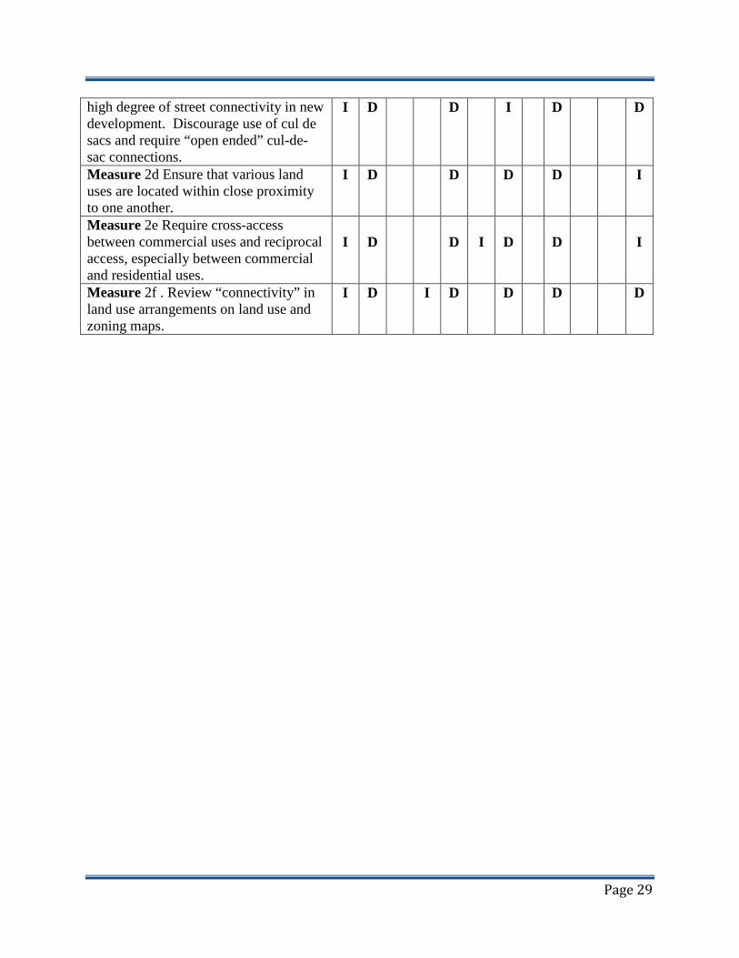
high degree of street connectivity in new development. Discourage use of cul de sacs and require “open ended” cul-de-sac connections.
I D D I D D
Measure 2d Ensure that various land uses are located within close proximity to one another.
I D D D D I
Measure 2e Require cross-access between commercial uses and reciprocal access, especially between commercial and residential uses.
I
D
D
I
D
D
I
Measure 2f . Review “connectivity” in land use arrangements on land use and zoning maps.
I D I D D D D

Page 30
Supports Blueprint “Smart Growth” Principal City Blueprint “Smart Growth” C
reat
e a
Ran
ge
of
Hou
sing
Opp
ort
un
ities
& C
ho
ices
Cre
ate
Wal
kab
le N
eig
hbo
rhoo
ds
En
cou
rag
e C
om
mu
nity
an
d S
take
ho
lder
Co
llab
ora
tion
En
han
ce R
egio
nal
Eco
nom
ic V
italit
y
Dis
tinct
ive
Att
ract
ive
Co
mm
un
ities
with
Sen
se o
f Pl
ace
Pre
dic
tab
le ,
Fai
r, a
nd C
ost
Effe
ctiv
e D
evel
opm
ent
Dec
isio
ns
Mix
ed L
and
Use
s
Pre
serv
e O
pen
Sp
ace,
Far
mla
nd
, etc
.
Var
iety
of
Tra
nsp
ort
atio
n C
hoic
es
Dire
ct D
evel
op
men
t to
Exi
stin
g C
om
mu
niti
es
Su
ppo
rt E
nviro
nm
enta
l Res
ourc
e M
anag
emen
t
Co
mp
act
Bu
ildin
g D
esig
n
Principal Implementation Measure 1 2 3 4 5 6 7 8 9 10 11 12 Measure 2g Develop alternative strategies to sound walls for residential development (side-on, frontage road, MF buffer, alley loaded, etc.).
I
D
D
I
D
I
I
D
Measure 2h Reduce parking requirements in residential and commercial zone districts..
D D D I D I D D
Measure 2i Develop standards for CPTED in Street/Sidewalk Design. (Crime Prevention through Environmental Design) that address sign placement, fencing and landscaping improvements?
D
I
I
I
D
I
3. Encourage community and stakeholder collaboration:
Measure 3a Publicize planning efforts on-line and through close communication with the media.
I
I
D
I
I
I
I
I
I
I
I
I
Policy 3b Develop interactive website, other social media, and post ongoing planning efforts and projects on city website.
I
I
D
I
I
I
I
I
I
I
I
I

Page 31
Measure 3c Work closely with community groups.
I I D I I I I I I I I I
Measure 3d Publish a monthly “Community Newsletter”.
I I D I I I I I I I I I

Page 32
Supports Blueprint “Smart Growth” Principal City Blueprint “Smart Growth” C
reat
e a
Ran
ge
of
Hou
sing
Opp
ort
un
ities
& C
ho
ices
Cre
ate
Wal
kab
le N
eig
hbo
rhoo
ds
En
cou
rag
e C
om
mu
nity
an
d S
take
ho
lder
Co
llab
ora
tion
En
han
ce R
egio
nal
Eco
nom
ic V
italit
y
Dis
tinct
ive
Att
ract
ive
Co
mm
un
ities
with
Sen
se o
f Pl
ace
Pre
dic
tab
le ,
Fai
r, a
nd C
ost
Effe
ctiv
e D
evel
opm
ent
Dec
isio
ns
Mix
ed L
and
Use
s
Pre
serv
e O
pen
Sp
ace,
Far
mla
nd
, etc
.
Var
iety
of
Tra
nsp
ort
atio
n C
hoic
es
Dire
ct D
evel
op
men
t to
Exi
stin
g C
om
mu
niti
es
Su
ppo
rt E
nviro
nm
enta
l Res
ourc
e M
anag
emen
t
Co
mp
act
Bu
ildin
g D
esig
n
Principal Implementation Measure 1 2 3 4 5 6 7 8 9 10 11 12 Principal 4. Enhance the Economic
Vitality of the Region:
Measure 4a Audit and update impact fees.
I D I I I I I
Measure 4b Lower/ eliminate impact fees for infill parcels.
I I D I I I I I
Measure 4c Maintain maps showing available land and utility connections.
I D I I I I I
Measure 4d Audit land use and zoning maps to ensure land availability.
I D I I I D I
Measure 4e Update utility master plans. I D I I I D I Measure 4f Consider adopting a policy allowing deferred payment of impact fees for select development projects.
I
D
I
I
I
D
I
Measure 4g Identify location and strategy for industrial park development and job creation.
I D I D I D I
Measure 4h Discourage “bedroom community” development strategies and promote “jobs-housing balance” strategies and standards.
I
D
I
I
I
D
I
Measure 4i Develop standards for the

Page 33
construction and improvement of regional telecommunications infrastructure (Cell Towers, Wifi, etc.).
I D I D I I I

Page 34
Supports Blueprint “Smart Growth” Principal City Blueprint “Smart Growth” C
reat
e a
Ran
ge
of
Hou
sing
Opp
ort
un
ities
& C
ho
ices
Cre
ate
Wal
kab
le N
eig
hbo
rhoo
ds
En
cou
rag
e C
om
mu
nity
an
d S
take
ho
lder
Co
llab
ora
tion
En
han
ce R
egio
nal
Eco
nom
ic V
italit
y
Dis
tinct
ive
Att
ract
ive
Co
mm
un
ities
with
Sen
se o
f Pl
ace
Pre
dic
tab
le ,
Fai
r, a
nd C
ost
Effe
ctiv
e D
evel
opm
ent
Dec
isio
ns
Mix
ed L
and
Use
s
Pre
serv
e O
pen
Sp
ace,
Far
mla
nd
, etc
.
Var
iety
of
Tra
nsp
ort
atio
n C
hoic
es
Dire
ct D
evel
op
men
t to
Exi
stin
g C
om
mu
niti
es
Su
ppo
rt E
nviro
nm
enta
l Res
ourc
e M
anag
emen
t
Co
mp
act
Bu
ildin
g D
esig
n
Principal Implementation Measure 1 2 3 4 5 6 7 8 9 10 11 12 Principal 5. Foster distinctive,
attractive communities with a strong sense of place:
Measure 5a Adopt design guidelines / standards for new development, architectural review procedures.
I
I
I
D
D
I
I
I
Measure 5b Erect entrance signs at key community entrances.
I D
Measure 5c Install antique style street lamps with banners, other streetscape improvements.
I I D I
Measure 5d Develop “Healthy Communities” policies, programs and standards.
I I I D I
Measure 5e Review sign ordinance, particularly with respect to “off-site” advertising standards.
I I D I
Measure 5f Develop/ strengthen community code enforcement provisions through adoption/implementation of “citation” enforcement system and review of “nuisance abatement”
I
I
I
D
D
I
I
I

Page 35
provisions. Measure 5g Review/update zoning codes with respect to “out-door sales” and “display” provisions.
I
I
D
D
D
I
I
I
Measure 5h Develop standards for permitting community street fairs, farmers markets and other types of community events including standards for the use of public streets, playgrounds and parks.
I
D
D
D
I
I
Measure 5i Develop standards for “community art” and “building murals”.
I I D I
Supports Blueprint “Smart Growth” Principal City Blueprint “Smart Growth” C
reat
e a
Ran
ge
of
Hou
sing
Opp
ort
un
ities
& C
ho
ices
Cre
ate
Wal
kab
le N
eig
hbo
rhoo
ds
En
cou
rag
e C
om
mu
nity
an
d S
take
ho
lder
Co
llab
ora
tion
En
han
ce R
egio
nal
Eco
nom
ic V
italit
y
Dis
tinct
ive
Att
ract
ive
Co
mm
un
ities
with
Sen
se o
f Pl
ace
Pre
dic
tab
le ,
Fai
r, a
nd C
ost
Effe
ctiv
e D
evel
opm
ent
Dec
isio
ns
Mix
ed L
and
Use
s
Pre
serv
e O
pen
Sp
ace,
Far
mla
nd
, etc
.
Var
iety
of
Tra
nsp
ort
atio
n C
hoic
es
Dire
ct D
evel
op
men
t to
Exi
stin
g C
om
mu
niti
es
Su
ppo
rt E
nviro
nm
enta
l Res
ourc
e M
anag
emen
t
Co
mp
act
Bu
ildin
g D
esig
n
Principal Implementation Measure 1 2 3 4 5 6 7 8 9 10 11 12 Measure 5j Develop standards for permitting community street fairs, farmers markets and other types of community events including standards for the use of public streets, playgrounds and parks.
I
D
D
D
I
I
Measure 5k Develop residential neighborhood identity.
I I I D I
Measure 5l Maintain & Enhance Neighborhood and overall Community
I I D I

Page 36
Environments Principal 6. Make development
decisions predictable, fair, and cost-effective
Measure 6a Update utility master plans and establish standards that limit variations to adopted master plan standards.
I
I
D
I
D
I
I
D
Measure 6b Publicize fees on the website.
I I D I D I
Measure 6c Publicize development standards on the website.
I I D I D I
Measure 6d Use graphics to illustrate zoning standards, where practical.
I I I D I D I
Measure 6e Increase “by right” uses when development standards are met.
I I I D I D I
Measure 6f Review general plan and zoning to remove inconsistencies and clarify development review process.
I
I
D
I
D
I
D
I
I
D
O
Measure 6g Include Zoning Code language that emphasizes performance “Standards” for non-residential uses.
I
I
D
I
D
I
D
I
D
I
I
Measure 6h Adopt CEQA Policies and Procedures, as required by law, that simplifies review process and maximizes legal exemptions.
I
I
D
I
D
I
D
I
D
I

Page 37
Supports Blueprint “Smart Growth” Principal City Blueprint “Smart Growth” C
reat
e a
Ran
ge
of
Hou
sing
Opp
ort
un
ities
& C
ho
ices
Cre
ate
Wal
kab
le N
eig
hbo
rhoo
ds
En
cou
rag
e C
om
mu
nity
an
d S
take
ho
lder
Co
llab
ora
tion
En
han
ce R
egio
nal
Eco
nom
ic V
italit
y
Dis
tinct
ive
Att
ract
ive
Co
mm
un
ities
with
Sen
se o
f Pl
ace
Pre
dic
tab
le ,
Fai
r, a
nd C
ost
Effe
ctiv
e D
evel
opm
ent
Dec
isio
ns
Mix
ed L
and
Use
s
Pre
serv
e O
pen
Sp
ace,
Far
mla
nd
, etc
.
Var
iety
of
Tra
nsp
ort
atio
n C
hoic
es
Dire
ct D
evel
op
men
t to
Exi
stin
g C
om
mu
niti
es
Su
ppo
rt E
nviro
nm
enta
l Res
ourc
e M
anag
emen
t
Co
mp
act
Bu
ildin
g D
esig
n
Principal Implementation Measure 1 2 3 4 5 6 7 8 9 10 11 12 7. Mix land uses Measure 7a Adopt a mixed use ordinance, or develop mixed-use standards in the cities Planned Development Zone.
D
D
D
D
D
D
I
D
D
D
Measure 7b Allow mixed use as a permitted use in appropriate zones subject to Mixed used Compatibility Standards.
D
D
D
D
D
D
I
D
D
D
Measure 7c Encourage both vertical and horizontal mixed uses in small communities.
D D D D D D I D D D
Measure 2d Identify areas/zone districts where mixed uses are allowed/ encouraged.
D D D D D D I D D D
Measure 7e Adopt special zoning standards (such as reduced parking requirements) for mixed uses
D
D
D
D
D
D
I
D
D
D
Measure 7f Adopt design guidelines / Standards for mixed uses.
D D D D D D I D D D
Measure 7g Develop “live-work” residential standards
D D D D D D I D D D

Page 38
Measure 7h Review/update “home-occupation” standards to minimize “nuisance” type conflicts in a residential neighborhood but promote home business that are enabled by modern telecommunications technology.
D
D
D
D
D
D
I
D
D
D

Page 39
Supports Blueprint “Smart Growth” Principal City Blueprint “Smart Growth” C
reat
e a
Ran
ge
of
Hou
sing
Opp
ort
un
ities
& C
ho
ices
Cre
ate
Wal
kab
le N
eig
hbo
rhoo
ds
En
cou
rag
e C
om
mu
nity
an
d S
take
ho
lder
Co
llab
ora
tion
En
han
ce R
egio
nal
Eco
nom
ic V
italit
y
Dis
tinct
ive
Att
ract
ive
Co
mm
un
ities
with
Sen
se o
f Pl
ace
Pre
dic
tab
le ,
Fai
r, a
nd C
ost
Effe
ctiv
e D
evel
opm
ent
Dec
isio
ns
Mix
ed L
and
Use
s
Pre
serv
e O
pen
Sp
ace,
Far
mla
nd
, etc
.
Var
iety
of
Tra
nsp
ort
atio
n C
hoic
es
Dire
ct D
evel
op
men
t to
Exi
stin
g C
om
mu
niti
es
Su
ppo
rt E
nviro
nm
enta
l Res
ourc
e M
anag
emen
t
Co
mp
act
Bu
ildin
g D
esig
n
Principal Implementation Measure 1 2 3 4 5 6 7 8 9 10 11 12 Principal 8. Preserve open space,
farmland, natural beauty, critical environmental areas
Measure 8a Review park land/population ratio standards and establish policies regarding “public” v. “private” open space off-sets for higher density development.
I
I
D
I
D
D
I
D
Measure 8b Review Park design standards.
I D I D D I D
Measure 8c Establish Parkland Dedication/Fee Standards.
I D I D D I D
Measure 8 d Review park impact fee. I D D D I D Measure 8e Adopt policies to establish open space buffers around the community.
I D D D D D I
Measure 8f Map prime farmland and ag preserves – review land use map to ensure these resources are protected. Implement Ag-Land Preservation Practices.
D
I
D
D
D
D
Measure 8g Require street trees in new

Page 40
developments; parking lot trees in new parking lots (shading factors).
D I D D I I D
Measure 8h Establish “urban limit” or “greenbelt” policies and standards regarding important farmland resources and or sensitive/valuable natural resource areas.
I
I
D
I
D
D
D
I

Page 41
Supports Blueprint “Smart Growth” Principal City Blueprint “Smart Growth” C
reat
e a
Ran
ge
of
Hou
sing
Opp
ort
un
ities
& C
ho
ices
Cre
ate
Wal
kab
le N
eig
hbo
rhoo
ds
En
cou
rag
e C
om
mu
nity
an
d S
take
ho
lder
Co
llab
ora
tion
En
han
ce R
egio
nal
Eco
nom
ic V
italit
y
Dis
tinct
ive
Att
ract
ive
Co
mm
un
ities
with
Sen
se o
f Pl
ace
Pre
dic
tab
le ,
Fai
r, a
nd C
ost
Effe
ctiv
e D
evel
opm
ent
Dec
isio
ns
Mix
ed L
and
Use
s
Pre
serv
e O
pen
Sp
ace,
Far
mla
nd
, etc
.
Var
iety
of
Tra
nsp
ort
atio
n C
hoic
es
Dire
ct D
evel
op
men
t to
Exi
stin
g C
om
mu
niti
es
Su
ppo
rt E
nviro
nm
enta
l Res
ourc
e M
anag
emen
t
Co
mp
act
Bu
ildin
g D
esig
n
Principal Implementation Measure 1 2 3 4 5 6 7 8 9 10 11 12 Principal 9. Provide a variety of
transportation choices
Measure 9a Promote Public Transportation System Development
D I D D D D
Measure 9b Adopt a complete streets program.
D D I D D D
Measure 9c Provide/ Improve Pedestrian Infrastructure
D D D D D
Measure 9d Establish a bike master plan and/or pedestrian plan.
D I D I D D D
Measure 9e Require Public Transit Improvements.
D I D I D D D
Measure 9f Adopt a master plan to establish walking and cycling trails along waterways and railroads.
D I D D D D D

Page 42
Supports Blueprint “Smart Growth” Principal City Blueprint “Smart Growth” C
reat
e a
Ran
ge
of
Hou
sing
Opp
ort
un
ities
& C
ho
ices
Cre
ate
Wal
kab
le N
eig
hbo
rhoo
ds
En
cou
rag
e C
om
mu
nity
an
d S
take
ho
lder
Co
llab
ora
tion
En
han
ce R
egio
nal
Eco
nom
ic V
italit
y
Dis
tinct
ive
Att
ract
ive
Co
mm
un
ities
with
Sen
se o
f Pl
ace
Pre
dic
tab
le ,
Fai
r, a
nd C
ost
Effe
ctiv
e D
evel
opm
ent
Dec
isio
ns
Mix
ed L
and
Use
s
Pre
serv
e O
pen
Sp
ace,
Far
mla
nd
, etc
.
Var
iety
of
Tra
nsp
ort
atio
n C
hoic
es
Dire
ct D
evel
op
men
t to
Exi
stin
g C
om
mu
niti
es
Su
ppo
rt E
nviro
nm
enta
l Res
ourc
e M
anag
emen
t
Co
mp
act
Bu
ildin
g D
esig
n
Principal Implementation Measure 1 2 3 4 5 6 7 8 9 10 11 12 Principal 10. Strengthen and direct
development towards existing communities
Measure 10a Adopt policies requiring coordination/consultation with the County when development is proposed nearby or within Sphere of Influence.
I
D
D
D
D
I
D
D
Measure 10b b. Establish “urban expansion” policies and standards that accommodate urban expansion needs but minimizes the impact on need to expand existing urban infrastructure.
I
D
D
D
D
I
D
D
Measure 10c c. Promote “in-fill” development with review of “impact fee/development fees”, standards of review, implementation of CEQA review exemptions, etc.
I
I
I
D
D
D
D
I
D
D
Measure 10d Encourage Infill Development and Compact Urban Form.
I I D D D I D D

Page 43
Supports Blueprint “Smart Growth” Principal City Blueprint “Smart Growth” C
reat
e a
Ran
ge
of
Hou
sing
Opp
ort
un
ities
& C
ho
ices
Cre
ate
Wal
kab
le N
eig
hbo
rhoo
ds
En
cou
rag
e C
om
mu
nity
an
d S
take
ho
lder
Co
llab
ora
tion
En
han
ce R
egio
nal
Eco
nom
ic V
italit
y
Dis
tinct
ive
Att
ract
ive
Co
mm
un
ities
with
Sen
se o
f Pl
ace
Pre
dic
tab
le ,
Fai
r, a
nd C
ost
Effe
ctiv
e D
evel
opm
ent
Dec
isio
ns
Mix
ed L
and
Use
s
Pre
serv
e O
pen
Sp
ace,
Far
mla
nd
, etc
.
Var
iety
of
Tra
nsp
ort
atio
n C
hoic
es
Dire
ct D
evel
op
men
t to
Exi
stin
g C
om
mu
niti
es
Su
ppo
rt E
nviro
nm
enta
l Res
ourc
e M
anag
emen
t
Co
mp
act
Bu
ildin
g D
esig
n
Principal Implementation Measure 1 2 3 4 5 6 7 8 9 10 11 12 Principal 11. Support Action that
Encourage Environmental Resource Management
Measure 11a Amend zoning ordinance to allow alternative forms of energy production (solar, wind, etc.).
I I I D D
Measure 11b Adopt an air quality element in keeping with state law requirements (AB 170).
D D
Measure 11c Adopt a hazardous materials element.
I D D
Measure 11d Adopt sustainable development goals, polices and standards that address water, air, biological resources, etc.
D D
Measure 11e Adopt standards that require solar orientation in new buildings, roofs, streets, etc.
I I D D
Measure 11f Develop policies and standards for solar energy development.
I I D D
Measure 11g Develop standards for development of residential, commercial
I I D D
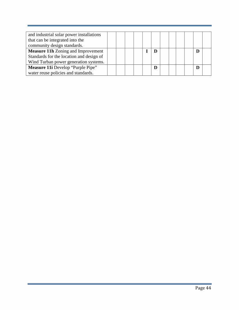
Page 44
and industrial solar power installations that can be integrated into the community design standards. Measure 11h Zoning and Improvement Standards for the location and design of Wind Turban power generation systems.
I D D
Measure 11i Develop “Purple Pipe” water reuse policies and standards.
D D
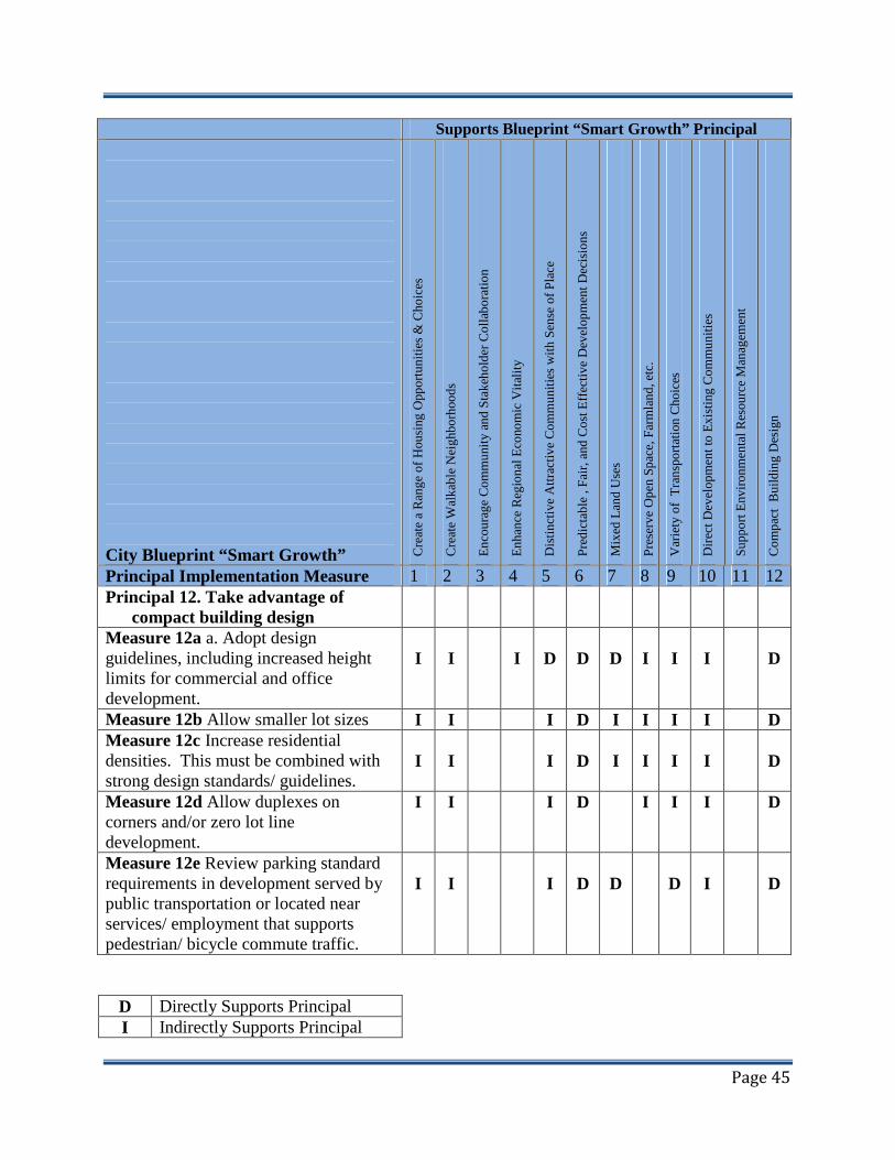
Page 45
Supports Blueprint “Smart Growth” Principal City Blueprint “Smart Growth” C
reat
e a
Ran
ge
of
Hou
sing
Opp
ort
un
ities
& C
ho
ices
Cre
ate
Wal
kab
le N
eig
hbo
rhoo
ds
En
cou
rag
e C
om
mu
nity
an
d S
take
ho
lder
Co
llab
ora
tion
En
han
ce R
egio
nal
Eco
nom
ic V
italit
y
Dis
tinct
ive
Att
ract
ive
Co
mm
un
ities
with
Sen
se o
f Pl
ace
Pre
dic
tab
le ,
Fai
r, a
nd C
ost
Effe
ctiv
e D
evel
opm
ent
Dec
isio
ns
Mix
ed L
and
Use
s
Pre
serv
e O
pen
Sp
ace,
Far
mla
nd
, etc
.
Var
iety
of
Tra
nsp
ort
atio
n C
hoic
es
Dire
ct D
evel
op
men
t to
Exi
stin
g C
om
mu
niti
es
Su
ppo
rt E
nviro
nm
enta
l Res
ourc
e M
anag
emen
t
Co
mp
act
Bu
ildin
g D
esig
n
Principal Implementation Measure 1 2 3 4 5 6 7 8 9 10 11 12 Principal 12. Take advantage of
compact building design
Measure 12a a. Adopt design guidelines, including increased height limits for commercial and office development.
I
I
I
D
D
D
I
I
I
D
Measure 12b Allow smaller lot sizes I I I D I I I I D Measure 12c Increase residential densities. This must be combined with strong design standards/ guidelines.
I
I
I
D
I
I
I
I
D
Measure 12d Allow duplexes on corners and/or zero lot line development.
I I I D I I I D
Measure 12e Review parking standard requirements in development served by public transportation or located near services/ employment that supports pedestrian/ bicycle commute traffic.
I
I
I
D
D
D
I
D
D Directly Supports Principal I Indirectly Supports Principal

Page 46
Little or No Support of Principal

Page 47
Attachment 2.
City of Waterford Valley Blueprint “Smart Growth” Principles Implementation.

48 | P a g e
Blueprint Principal 1. Create a range of housing opportunities and choices Suggested Strategies:
Type Implementat
ion
City of Waterford Implementation
Notes/Comme
nts 1a. Adopt/revise design guidelines that promote development of a mixture of housing types within a residential area and promotes development quality.
General Plan Policy Zoning Code Waterford Community Design Guidelines
General Plan, Land Use Element, Policy L-1.2 Encourage a diversity of building types,
ownership, prices, designs, and site plans for residential areas throughout the city.
L-1.3 Encourage a diversity of lot sizes in residential subdivisions.
General Plan, Housing Element, Policy: H-1.d Accommodate and encourage
development of a full range of housing types within the city.
H-2.b Encourage application of community design standards that will provide for the development of safe, attractive, and functional housing developments.
H-3.b Encourage the development of various types of housing opportunities in all residential areas.
Subdivision Code: Chapter 16.03 Design Requirements. Waterford Subdivision Code. Zoning Code: Chapter 17.20”R: Residential Districts Chapter 17.42General Mixed-Use
Compatibility Standards Chapter 17.40.220 Duplex Units on Corner
Lots within the “RS” District. Waterford Zoning Code.
Note: The City of Waterford has initiated the process of updating its Community Design Guidelines. An update recommendation is that “design elements” contained in the City General Plan (Urban Design Chapter 7.0) City Zoning Code, Subdivision Code and Urban Forest Plan be included in these updated Guidelines to provide a comprehensive document on Waterford Urban Design
1b. Develop Policies that creates incentives for developers willing to develop a mixture of
General Plan Policy, Zoning Code, Subdivision Code.
General Plan, Land Use Element Policies: L-1.1 Promote balanced development which
provides jobs, services and housing. L-1.6 Continue to pursue quality single-family
and higher density residential development. L-1.7 Encourage the location of multi-family
developments on sites with good access to transportation, shopping, and services.

49 | P a g e
housing opportunities and choices in housing design and development.
L-1.8. Create livable and identifiable residential neighborhoods.
General Plan, Housing Element Policies: H-1.a Advocate and support proposed federal
and state actions that will create a positive, stable climate for housing production.
H-1.b Wherever appropriate, facilitate the use of federal or state programs which can assist in development of new housing consistent with identified city-wide housing needs and adopted local plans and programs.
H-1.c Support efforts that serve to coordinate and improve the ability of the housing delivery system to effectively respond to local housing needs.
Suggested Strategies:
Type Implementat
ion
City of Waterford Implementation
Notes/Comme
nts 1b. Continued General Plan
Policy, Zoning Code, Subdivision Code.
H-1.e Maintain a sufficient inventory of developable land to accommodate timely development of needed new housing supplies.
H-1.f Encourage and participate in efforts designed to achieve economies and efficiencies which will facilitate the production of quality, affordable housing.
H-1.g Promote balanced, orderly growth to minimize unnecessary developmental costs that add to the cost of housing.
H-2.a Provide that new housing be constructed in accordance with design standards that will ensure the safety and integrity of each housing unit.
H-4.i Encourage proper maintenance of essential public services and facilities in residential developments.
H-4.j Encourage available public and private housing rehabilitation assistance programs where such action is needed to insure preservation of the living environment.
H-4.k Facilitate maximum utilization of federal and state programs which can assist lower-income homeowners to properly maintain their dwelling units.

50 | P a g e
H-5.a Encourage enforcement of fair housing laws throughout the city.
H-5.d Encourage full utilization of federal and state housing assistance programs which can enable those persons with unmet housing needs to obtain decent housing at prices they can afford.
H-5.e Support development of housing plans and programs, including new government subsidized housing, that maximizes housing choice for minorities and lower-income households commensurate with need.
H-5.f Wherever possible, implement adopted land development and resource management policies without imposing regulations that have the effect of excluding housing for lower-income groups.
Zoning Code: Chapter 17.34 “DBO” Density Bonus Overlay District Chapter 17.30 “PC” Planned Community District Chapter 17.32 “SP” Specific Plan District

51 | P a g e
Suggested Strategies:
Type Implementat
ion
City of Waterford Implementation
Notes/Comme
nts 1c. Review zoning standards to ensure that a variety of housing types are possible (or Develop flexible residential Zoning standards {Setbacks, yards, etc.} that accommodates higher density potential in single-family residential neighborhoods.).
General Plan Zoning Code
General Plan, Housing and Land Use Element. Policy L-1.6. Continue to Pursue Quality Single-Family And Higher Density Residential Development. 1.6.a Continue to review proposed subdivision
designs to ensure the provision of adequate circulation, public improvements, common open space, landscaping, maintenance, etc. through the Development Review process.
1.6.b Multi-family projects must comply, at minimum, with the adopted standards and design guidelines contained in the "City of Waterford’s Design Standards and Guidelines."
Policy L-1.7 Encourage the Location of Multi-Family Developments on Sites With Good Access to Transportation, Shopping, and Services. 1.7.a Designate areas adjoining arterial streets,
major transportation routes and commercial areas for multi-family development.
1.7.b Use the “Neo-Traditional” or “New Urbanist” Concepts to promote higher density residential development adjacent to commercial services and transit.
Zoning Code: Chapter 17.20 “R” General Residential Districts. Chapter 17.40 General Regulations. Section 17.40.090 Development of Sub-Standard Lots. Section 17.40.100 Yards. Section 17.40.160 Accessory Residential Units. Section 17.40.220 Duplex Units on Corner Lots. Chapter 17.34 “DBO” Density Bonus Overlay District Chapter 17.30 “PC” Planned Community District Chapter 17.32 “SP” Specific Plan District
1d. Establish Zoning Code Zoning Code:

52 | P a g e
standards that Allow duplexes on corner lots.
Section 17.40.220 Duplex Units on Corner Lots.
1e. Establish zero lot line developments standards.
Zoning Code.
General Plan, Land Use Element. Zoning Code: Chapter 17.34 “DBO” Density Bonus Overlay District Chapter 17.30 “PC” Planned Community District Chapter 17.32 “SP” Specific Plan District Chapter 17.42 “SP” General Mixed Use
Compatibility Standards

53 | P a g e
Suggested Strategies:
Type Implementat
ion
City of Waterford Implementation
Notes/Comme
nts 1f. Adopt mobile home/modular home design standards.
Zoning Code General Plan, Urban Design Element Zoning Code: Chapter 17.22 “RM” Mobile Home Park District Chapter 17.36 Mobile Living Units Chapter 17.57Mobile and Manufactured Homes
1g. Adopt Second Dwelling unit ordinance in accordance with state law.
General Plan Zoning Code
General Plan, Housing Element Zoning Code: Chapter 17.20 “R” General Residential Districts Chapter 17.40.160 Accessory Residential Units. Purpose. This section is intended to implement the requirements of the Waterford Housing Element in accordance with Government Code Section 65852.2 by permitting the creation of accessory dwelling units through an administrative process, thereby increasing housing opportunities for the community through use of existing housing resources and infrastructure.
1h. Reduced impact fees, parking flexibility or energy efficiency for lower-income housing inclusion.
Zoning Code General Plan, Housing Element H-6.a Advocate and support proposed federal and state actions to promote energy conservation. H-6.b Promote public awareness of the need for energy conservation. H-6.c Promote development of public policies and regulations that achieve a high level of energy conservation in all new and rehabilitated housing units. H-6.d Encourage maximum utilization of federal and state programs that assist homeowners in providing energy conservation measures Zoning Code: Chapter 17.34 “DBO” Density Bonus Overlay District
1i. COGs to COG StanCOG is working with cities within

54 | P a g e
assist small communities in next round of Housing Elements to facilitate SB375 compliance.
Housing Allocation Plan City Housing Element Update
Stanislaus County in the update of the Regional Housing Allocation Plan. STANCOG is also updating its Regional Transportation Plan that includes a “Sustainable Communities” Element (Valley Vision Stanislaus), in compliance with SB 375,
1j. Develop mixed use policies and standards for residential development in downtown area.
Zoning Code General Plan, Land Use Element, Policy L-1.1 Promote Balanced Development Which Provides Jobs, Services and Housing. Policy L 1.1.a Promote mixed use development combining compatible employment, service and residential elements. Zoning Code: Chapter 17.42 General Mixed Use Compatibility Standards.
Suggested Strategies:
Type Implementat
ion
City of Waterford Implementation
Notes/Comme
nts 1k. Develop density bonus standards that target Special Needs populations.
Zoning Code General Plan, Housing Element, Policy: H-3.c Establish density bonus procedures that encourage the provision of affordable housing. Zoning Code: Chapter 17.34 “DBO” Density Bonus Overlay District.
Blueprint Principal 2. Create walkable neighborhoods Suggested Strategies:
Type Implementat
ion
City of Waterford Implementation
Notes/Comme
nts 2a. “Complete Streets” policy.
Non-Motorized Transportation Plan
General Plan, Circulation Element. The City of Waterford has a Non-Motorized Transportation Plan prepared by Fehr-Peers Transportation Consultant for the Stanislaus County Council of Governments (StanCOG). The planning process is part of a major effort by various public agencies to comply with several requirements of State Law.
A model “Complete Streets” policy has been developed for the City of Newman that can be adapted to the

55 | P a g e
According to the California Streets and Highways Code, Sections 890 through 894.2, local agencies must complete a Bicycle Transportation Plan (BTP) to qualify for grant funds issued by the Caltrans through the Bicycle Transportation Account (BTA). Conforming plans must be no more than five years old. To maintain eligibility for BTA funding, the City should update the BTP on a five-year cycle. The BTP establishes goals, policies, implementation actions and priorities for the development of bicycle facilities in the Waterford as envisioned by the City’s newly updated General Plan. In addition to the requirements of the Streets and Highways Code, California Complete Streets Act of 2008 (AB 1358) mandates that a new or updated General Plan Circulation Element be based on complete streets principles. Recently the Governor has proposed consolidation of the Bicycle Transportation Account with the Safe Routes to Schools Account along with other programs related to Bicycle Transportation funding.
City of Waterford for compliance with AB 1358. The Newman policy document should be reviewed for consistency with the adopted Non-Motorized Transportation Plan.

56 | P a g e
Suggested Strategies:
Type Implementat
ion
City of Waterford Implementation
Notes/Comme
nts 2b. Revise street standards to narrow local streets and require parkways with street trees and implement “traffic calming” strategies in residential neighborhoods.
General Plan Zoning Code, Municipal Improvement Standards
General Plan, Circulation Element Policy T-1.1 Design Streets Consistent with Circulation Function and Affected Land Uses. Implementing Actions: 1.1.a Implement the general plan circulation
plan (Figure 5.1) as development occurs. 1.1.b Whenever feasible, implement a system
of arterials and higher order streets in new growth areas based upon the adopted concept of arterials.
1.1.c Evaluate existing streets in older portions of the City, and identify means of upgrading the system where necessary.
1.1.d Design and build residential collector streets that balance as effectively as possible competing needs to be safe and efficient.
1.1.e Study projected future areas of city expansion prior to development to identify the most effective circulation pattern(s).
1.1.f Evaluate the area in proximity to the Highway 132 and Tim Bell intersection to obtain at least preliminary information regarding the general extent of area required to achieve an acceptable alignment of the intersection.
1.1.g Evaluate the current Tim Bell driveway access points to determine if a more appropriate access locations could be developed to minimize cars backing onto the roadway.
Policy T-1.3 Design Major Roads to Maximize Efficiency. Implementing Actions: 1.3.a Adhere, to the greatest possible extent, to
the standards adopted for spacing streets that intersect arterials and higher order roadways.
1.3.b Improve traffic flow of all new arterial streets to the greatest possible extent by the use of median strips of sufficient width to facilitate vehicle movement.
1.3.c Improve traffic flow of arterials and other

57 | P a g e
major roadways, whenever possible, by avoiding or eliminating on-street parking.
1.3.d Work to insure that land uses fronting major streets have shared access across adjacent properties and provide sufficient on-site parking to avoid depending upon on-street parking.
1.3.e Promote the provision of on-site visitor parking in multi-family projects.
1.3.f Whenever feasible, avoid, or eliminate, unnecessary or poorly placed median openings.
1.3.g Avoid residential “fronting lots” on major collectors and higher order streets.
1.3.h Obtain, whenever feasible, necessary rights-of-way in proximity to major intersections for needed turn lanes.
Suggested Strategies:
Type Implementat
ion
City of Waterford Implementation
Notes/Comme
nts 2b Continued 1.3.i In new growth areas, obtain expanded
arterial intersection rights-of-way (ROW) requirements.
1.3.j Maintain the land use and access restrictions identified for major collector and higher order street intersections.
1.3.k Approve driveway access locations only if consistent with approved minimum acceptable distances from major intersections, except in
unusual circumstances.
2c. Adopt policies requiring a high degree of street connectivity in new development. Discourage use of cul de sacs and require “open ended” cul-de-sac connections.
General Plan General Plan, Land Use Element Policy L-3.1 Create Land Use Patterns That Will Encourage People to Walk, Bicycle, or Use Public Transit For an Increased Number of Their Daily Trips. Implementing Actions: 3.1.a Encourage pedestrian or transit-friendly designs at suitable locations 3.1.b Work to preserve and enhance existing neighborhoods and commercial districts which have transit and pedestrian-friendly designs. 3.1.c Plan areas for higher density development within 1/4 mile of locations identified as transit hubs and commercial centers.

58 | P a g e
3.1.d Encourage higher housing densities in areas served by the full range of urban services. • Encourage high and medium-density housing at sites
within walking distance of transit and neighborhood commercial services during General Plan updates and developer initiated General Plan amendments.
• Consider higher housing densities for areas around existing and planned transit hubs.
• Encourage developers to take advantage of density bonus provisions of the Zoning Ordinance for projects located around transit hubs on existing or planned transit corridors.
3.1.e Encourage mixed-use developments that provide commercial services such as day care centers, restaurants, banks, and stores near employment centers. 3.1.f Work closely with school districts to help them choose school site locations that allow students to safely walk or bicycle from their homes. 3.1.g Encourage regional shopping malls/centers at sites capable of support by a full range of transportation options. 3.1.h Consider air quality and mobility when reviewing any proposed change to the land use pattern of this community.

59 | P a g e
Suggested Strategies:
Type Implementat
ion
City of Waterford Implementation
Notes/Comme
nts 2c Continued Policy L-3.3 Promote Site Designs That
Encourage Walking, Cycling, and Transit Use. Implementing Actions: 3.3.a Encourage project designs which increase
the convenience, safety and comfort of people using transit, walking or cycling.
3.3.b Encourage all subdivision street and lot designs, commercial site plans, and multi-family site plans to improve access by transit, bicycle, and walking.
• Direct access to commercial centers from surrounding neighborhoods.
• Intra-development designs that incorporate integrated street patterns rather than designs which limit ingress and egress options to the development and restrict traffic to a limited number of arterials.
• Primary ground-floor commercial building entrances should orient to plazas, parks, or pedestrian-oriented streets, as feasible, not to interior blocks or parking lots.
• Promote the use of trees and plants in travel-way landscaping and residences.
• Building facades should be varied and articulated to provide visual interest to pedestrians.
• Street trees should be spaced no further than 40 feet on center in planter strips or tree wells. Tree species should be selected to create a unified image for the street and provide an effective canopy.
• Sidewalks should provide an unobstructed path. Larger sidewalk dimensions are desirable in core commercial areas where pedestrian activity will be greatest.
Encourage the use of front porches, bay window, and balconies which face onto the street to increase social interaction and provide heightened security for residential streets.
2d. Ensure that various land uses are located within close proximity to one another.
General Plan General Plan: Land Use Element Policy L-1.7 Encourage the Location of Multi-Family Developments on Sites With Good Access to Transportation, Shopping, and Services. Implementing Actions: 1.7.a Designate areas adjoining arterial streets,
major transportation routes and commercial

60 | P a g e
areas for multi-family development. 1.7.b Use the “Neo-Traditional” or “New
Urbanist” Concepts to promote higher density residential development adjacent to commercial services and transit.
Housing Element Policy H-5.c Encourage development of a range of housing for all income levels in proximity to existing and planned employment centers.
Suggested Strategies:
Type Implementat
ion
City of Waterford Implementation
Notes/Comme
nts 2e. Require cross-access between commercial uses and reciprocal access, especially between commercial and residential uses.
General Plan General Plan, Land Use Element Policy L-3.3 Promote Site Designs That Encourage Walking, Cycling, and Transit Use. Implementing Actions: 3.3.a Encourage project designs which increase the convenience, safety and comfort of people using transit, walking or cycling. 3.3.b Encourage all subdivision street and lot designs, commercial site plans, and multi-family site plans to improve access by transit, bicycle, and walking. • Direct access to commercial centers from surrounding
neighborhoods. • Intra-development designs that incorporate integrated
street patterns rather than designs which limit ingress and egress options to the development and restrict traffic to a limited number of arterials.
• Primary ground-floor commercial building entrances should orient to plazas, parks, or pedestrian-oriented streets, as feasible, not to interior blocks or parking lots.
• Promote the use of trees and plants in travel-way landscaping and residences.
• Building facades should be varied and articulated to provide visual interest to pedestrians.
• Street trees should be spaced no further than 40 feet on center in planter strips or tree wells. Tree species should be selected to create a unified image for the street and provide an effective canopy.
• Sidewalks should provide an unobstructed path. Larger sidewalk dimensions are desirable in core commercial areas where pedestrian activity will be greatest.
• Encourage the use of front porches, bay window, and balconies which face onto the street to increase social interaction and provide heightened security for residential streets.

61 | P a g e
Policy T-3.4 Locate and Design New Commercial Developments To Provide Good Access from Adjacent Neighborhoods and Reduce Congestion on Major Streets. Implementing Actions: 3.4.a New retail commercial designations shall be located along arterials or major collectors at their intersections with collector streets (at 1/4 mile or 1/2 mile locations) in new growth areas. These commercial areas should not be located at the intersections of two arterials. 3.4.b Commercial centers shall be designed to provide direct vehicular and pedestrian access from surrounding neighborhoods. In no case shall trips which could be internal (from adjacent neighborhood to center) be forced onto an arterial or major collector.
Suggested Strategies:
Type Implementat
ion
City of Waterford Implementation
Notes/Comme
nts 2e Continued 3.4.c The number of commercial driveways on
major streets shall be minimized and located in areas where they will cause minimal conflicts with traffic flow on major streets and through intersections. 3.4.d Cross-access and shared driveways between adjacent commercial uses shall be provided as much as feasible. 3.4.e Commercial developments shall be designed to encourage pedestrian, bicycle, and transit access.
2f. Review “connectivity” in land use arrangements on land use and zoning maps.
General Plan Zoning Code Municipal Improvement Standards
General Plan, Land Use Element, Policy L-2.4. Provide a Range of Services Adjacent to and Within Industrial Areas to Reduce Auto Trips. Implementing Actions: 2.4.a Establish a zoning designation called "business park" which would allow a mix of heavy commercial, "back office," and light industrial uses. 2.4.b Continue to allow services, such as restaurants and other retail commercial uses, which mainly serve industrial employees, to

62 | P a g e
locate in industrial zones as discretionary uses. 2.4.c Consideration should be given to providing attractive, efficient, and affordable means of mass transit between industrial areas and residential areas of the City. 2.4.d Promote industrial mixed use centers through changes in the Zoning Ordinance. Policy L-2.7 Locate and Design New Commercial Developments To Provide Good Access from Adjacent Neighborhoods and Reduce Congestion on Major Streets. Implementing Actions: 2.7.a New retail commercial designations shall be located along arterials at their intersections with collector streets (at 1/4 mile or 1/2 mile locations) in new growth areas. These commercial areas should not be located at the intersections of two arterials. 2.7.b Commercial centers shall be designed to provide direct vehicular and pedestrian access from surrounding neighborhoods. In no case shall trips which could be internal (from adjacent neighborhood to center) be forced onto an arterial. 2.7.c The number of commercial driveways on major streets shall be minimized and located in areas where they will cause minimal conflicts with traffic flow on major streets and through intersections. 2.7d Cross-access and shared driveways between adjacent commercial uses shall be provided as much as feasible.
Suggested Strategies:
Type Implementat
ion
City of Waterford Implementation
Notes/Comme
nts 2f Continued 2.7e Commercial developments shall be
designed to encourage pedestrian, bicycle, and transit access. Sidewalks, pedestrian access-ways, bike racks and/or lockers, on-site transit stops, and transit shelters are among the design features that can be used in commercial areas to encourage alternative modes of access for their customers.

63 | P a g e
Zoning Code: Chapter 17.42General Mixed Use
Compatibility Standards.
2g. Develop alternative strategies to sound walls for residential development (side-on, frontage road, MF buffer, alley loaded, etc.).
General Plan Zoning Code Subdivision Code
General Plan, Noise/Land Use Elements Zoning Code: Chapter 17.62 Fences Walls and Hedges. Chapter 17.54.200 Additional Design
Standards for Parking Lots and Structures. Chapter 17.180 Parking Lot Landscaping. Subdivision Code: Chapter 16.03.16 Service Road and Off-Street Parking. Chapter 16.03.06 Walls and Fences. Chapter 16.03.07 Noise Attenuation.
2h. Reduce parking requirements in residential and commercial zone districts..
General Plan Zoning Code
General Plan, Circulation Element Zoning Code: Chapter 17.54 Off-Street Parking.
Chapter 17.54.050 Increased Parking In Senior Citizens Housing.
Chapter 17.54.060 Reduced Parking for Other Uses.
Chapter 17.54.200 Additional Design Standards for Parking Lots and Structures.
Chapter 17.54.210 Location and Design of Off-Street Loading Spaces.
Chapter 17.54.220 “In-Lieu-Of” Parking Payments.
2i. Develop standards for CPTED in Street/Sidewalk Design. (Crime Prevention through Environmental Design) that address sign placement, fencing and
General Plan General Plan, Urban Design, Chapter 7.9 Crime Prevention Through Environmental Design (CPTED) Zoning Code: Various Sections

64 | P a g e
landscaping improvements. Blueprint Principal 3. Encourage community and stakeholder collaboration Suggested Strategies:
Type Implementat
ion
City of Waterford Implementation
Notes/Comme
nts 3a. Publicize planning efforts on-line and through close communication with the media.
General Planning Admin.
Waterford Municipal Code/City Policy
The City of Waterford publishes stories and planning information in the local Waterford News newspaper on a regular basis.
3b. Develop interactive website, other social media, and post ongoing planning efforts and projects on city website.
General Planning Admin.
City of Waterford Web Site: http://cityofwaterford.org/ City of Waterford Facebook (interactive) site: https://www.facebook.com/cityofwaterford?fref=ts
3c. Work closely with community groups.
General Planning Admin.
There is no formal City Code or regulation on working with community groups but the City has a long-standing tradition or working with various civic organizations including the local Lions Club, Veteran Groups, etc. Additionally, the City has formal cooperative agreements with various sports organizations throughout the City including the Waterford Historical Society, Friends of the River, Senior Citizen organizations, etc.
3d. Publish a monthly “Community Newsletter”.
General Planning Admin.
The City staff publish a monthly Newsletter that is distributed by e-mail and posted on the City’s Website.
Blueprint Principal 4. Enhance the economic vitality of the region

65 | P a g e
Suggested Strategies:
Type Implementat
ion
City of Waterford Implementation
Notes/Comme
nts 4a. Audit and update impact fees.
General Plan Waterford Municipal Code.
General Plan, Public Facilities Element, Policy: PF-1.1 Establish and maintain adequate & uniform municipal infrastructure and service standards. PF-1.2 Establish and maintain a program for cost effective operation and maintenance of municipal services and facilities to meet community needs. PF-1.3 Establish and maintain a program for cost effective expansion of municipal services and facilities to meet future community growth needs. PF-1.4 Establish and maintain facility maintenance programs that assure maximum utilization of capital equipment and facilities.
Suggested Strategies:
Type Implementat
ion
City of Waterford Implementation
Notes/Comme
nts 4a Continued Waterford Municipal Code:
Chapter 3.60 Fees. 3.60.90 public hearing – Fee resolution. Subsection B. All fees shall be automatically adjusted annually for inflation by the City administrative officer. The adjustment shall occur on March 1 of each year in accordance with an annual increase in the Engineering News Record Index for the twelve (12) month period ending in the preceding December. (Ord. 07-04, §1, 2007.) 3.60.130 Capital improvement plan.
B. The public facilities fee schedule adopted by the City Council shall be annually reviewed by the City Council for consistency with the capital improvement plan. (Ord. 07-04, §1, 2007.)
4b. Lower/ eliminate impact fees for infill parcels.
General Plan Municipal Impact Fee Study/Code
General Plan, Public Facilities and Services Element, PF-1.5 Assure that expansion of the city results in the enhancement of municipal services and facilities within Waterford without increasing

66 | P a g e
costs to the existing city. Policy Section 6.3.8 Capital Facilities & Infrastructure Extension to Future Growth Areas: “In all cases, it is the policy of the City of Waterford that New Urban Growth Shall Improve the Circumstances of the City of Waterford and Benefit the Community as a Whole. This is particularly true with respect to the impact of urban expansion on the City’s services and infrastructure. In no case will the City consider adding a new urban area to the existing City limits where that addition can be found, by the City Council, to adversely impact the current level of urban services in the City, or result in costly new improvement costs that would need to be borne by the citizens of Waterford.”
City of Waterford Capital Plan Report Prepared by Charles A. Long Associates, April 16, 2007 The new capital program totals $167.2 million allocated among three areas of benefit: 1. Existing deficiencies: These facilities
serve the existing population and the City will need to find non-fee financing sources to pay for them. Total costs in this category are approximately $8.3 million.
2. Growth-related Facilities benefiting the Entire City: These facilities serve growth of the entire city and will be paid for with new CFF levied on growth anywhere in the City. Costs in this allocation are approximately $84 million.
Suggested Strategies:
Type Implementat
ion
City of Waterford Implementation
Notes/Comme
nts 4b Continued 3. Growth-related Facilities benefiting the
Annexation Area Only: These facilities serve growth outside the existing city limits, primarily in the new Annexation Area and will be paid for

67 | P a g e
by a CFF levied only in the area outside the existing city limits, except the CFF for Water, which will be levied outside the service area of the City of Modesto water system. Total costs in this allocation are approximately $74.5 million.
The report recommends levying CFF on the basis of Equivalent Dwelling Units (EDU), which is the amount of service equivalent to that required by a single family dwelling unit. Based on the calculated fees, the total CFF per EDU in the two growth areas of benefit would be as follows: Residenti
al $/EDU
Commercial $/EDU
CFF for Entire City
$16,998
$11,730
Additional CFF Growth Area
$15,705
$15,705
Total CFF in Annexation Area
$32,703
$27,435
4c. Maintain maps showing available land and utility connections.
General Planning Administration
See 4 a and b above.
4d. Audit land use and zoning maps to ensure land availability.
General Planning Administration
See 4 a and b above.
4e. Update utility master plans.
Utility Master Plan
See 4 a and b above.
4f. Consider adopting a policy allowing deferred payment of impact fees for select development projects.
Municipal Impact Fee Codes
See 4 a and b above.
Suggested Type City of Waterford

68 | P a g e
Strategies: Implementation
Implementation Notes/Comments
4g. Identify location and strategy for industrial park development and job creation.
General Plan Zoning
General Plan, Land Use Element, Policy L-2.1 Encourage Further Development of Appropriate Commercial and Industrial Uses Throughout the City. Implementation: 2.1.a Designate adequate amounts of commercial and industrial land to serve the City's employment needs through 2025 and beyond. 2.1.c Continue the City's Economic Development activities. 2.1.d Develop incentives as appropriate to encourage new commercial and industrial development. 2.1.e Specifically target Central Waterford as an area that needs more commercial retail and office development. 2.1.f Promote industrial development that offers full-time, non-seasonal employment. 2.1.g Maintain a list of target industries for economic development purposes. Policy L-2.2 Locate New or Expanded Industrial Parks in Appropriate Areas. Implementation: 2.2.a Industrial areas should be located where they will have reasonably good access to the region’s air, rail, and major highway transportation links to the west. 2.2.b Industrial reserve areas should be protected from non-industrial use or premature development through agricultural zoning until such time as the land is needed for industrial development. 2.2.c Parcels of land in industrial reserve areas should remain as large as possible in order to accommodate a variety of plant sizes and types in the future. 2.2.d Develop an action program which outlines priorities for annexing new industrial and commercial areas and includes plans for providing services and infrastructure to these future industrial/commercial areas.

69 | P a g e
Policy L-2.3. Promote the Retention and Expansion of Implementation: Existing Industrial and Commercial Businesses. 2.3.a Protect industrial areas from encroachment by non-industrially-related uses. 2.3.b Assist existing industrial uses in relocating out of the Highway 132/Tuolumne River corridor to areas within the City’s Urban Planning Area. 2.3.c Continue to improve the permit approval process to ensure that industrial development projects are approved in a timely manner. 2.3.d Maintain a business outreach program to ensure that the needs of existing businesses are being met.
Suggested Strategies:
Type Implementat
ion
City of Waterford Implementation
Notes/Comme
nts 4g Continued Policy L-2.5. Maintain Attractive Industrial
Areas. Implementation: 2.5.a Continue to require Site Plan Review of new industrial development and the application of standards regarding landscaping, appearance, circulation, access, and parking. 2.5.b Consider requiring the planting of parking lot trees in industrial areas, perhaps at a reduced standard instead of the one tree for each six parking spaces required in other areas, to provide shade, reduce glare, and reduce reflective heat. 2.5.c Require the removal or screening of all rubbish, abandoned buildings, processing wastes, old equipment, or other forms of blight in industrial areas. 2.5.d Investigate the possibility of regulating industrial development on the basis of or in combination with performance standards instead of strictly by definition of specific allowable uses as in the Zoning Ordinance. Zoning Code:
Chapter 17.44 Performance Standards.

70 | P a g e
4h. Discourage “bedroom community” development strategies and promote “jobs-housing balance” strategies and standards.
General Plan General Plan, Land Use Element, Policy: Policy L-1.1 Promote Balanced Development Which Provides Jobs, Services and Housing. 1.1.b Periodically review job growth statistics in the Waterford urban area compared to new residential development. 1.1.c Determine the types of housing opportunities needed for the type of employment opportunities being created in the City.
The City should periodically review State employment statistics for the Waterford urban service area and determine if new housing construction has been occurring in relative balance with job growth. Value and type of housing should be somewhat related to the types of jobs being created. Over time, if it appears that normal market forces are not matching housing growth with employment, the City may need to take action to promote the appropriate type of housing development by type and location.
Policy L-2.6. Provide Neighborhood Commercial Centers In Proportion to Residential Development in the City. 2.6.a Neighborhood commercial centers should be located approximately one mile apart along major A one-mile radius is the standard service area for neighborhood commercial centers. Therefore, in order to ensure that most residents in Waterford have ready access to commercial services, neighborhood commercial centers should be located at regular intervals (approximately one for each square mile of residential development) along major streets within the City’s Urban Planning Area.
Suggested Strategies:
Type Implementat
ion
City of Waterford Implementation
Notes/Comme
nts 4h Continued Policy H-5.b Support programs that increase
employment and economic opportunities.
4i. Develop standards for the
Zoning Code Zoning Code: Chapter 17.50 Wireless Communications Facilities.

71 | P a g e
construction and improvement of regional telecom-munications infrastructure (Cell Towers, Wifi, etc.).
Blueprint Principal 5. Foster distinctive, attractive communities with a strong sense of
place Suggested Strategies:
Type Implementat
ion
City of Waterford Implementation
Notes/Comme
nts 5a. Adopt design guidelines / standards for new development, architectural review procedures.
Design Guidelines Zoning Code
General Plan, Urban Design Element: Urban Design Vision: A community that retains it rural small-town flavor with a central downtown surrounded by residential and other types of supporting development; a community whose appearance and overall architectural character promotes and reflects its unique rural setting along the Tuolumne River and its “gateway” status to the recreation areas to the east of the City. The following guiding principles provide a basis for the urban design goals and policies of this chapter as well as the subsequent elements of the general plan, in the implementation of the City’s urban design “vision”. • Heighten the sense of the natural landscape. • Reinforce the unique identity of Waterford. • Emphasize the role of downtown as the
heart of the community. • Enhance the special qualities of existing
neighborhoods and districts. • Reintegrate transitioning industrial and
commercial districts. • Establish linking elements that provide
continuity and connection within the City. • Reclaim streets as public space. • Emulate the positive qualities of traditional
Waterford neighbor-hoods in new
The City of Waterford has initiated a program to update its Design Guidelines that integrate “design” elements from the General Plan, Subdivision Code and Zoning Code. These Guidelines will also include design details from the City’s Non-Motorized Transportation Plan and any Complete Streets improvement standards.

72 | P a g e
development. Zoning Code: Chapter 17.52 Architectural Design Review Procedures Chapter 17.72 Standards of Review
Suggested Strategies:
Type Implementat
ion
City of Waterford Implementation
Notes/Comme
nts 5a Continued Subdivision Code:
Chapter 16.03 Design Requirement by Type of Subdivision.
16.03.02 General Design Standards: A. Concepts of “New Urbanism” or “Traditional Neighborhood Development” are encouraged through the design of subdivisions by the City of Waterford. These development approaches promote sustainable development in the City of Waterford through: 1. Creating more efficient land use,
minimizing agricultural land lost to urban development,
2. Promoting compact and pedestrian-friendly neighborhoods,
3. Promoting a mixture of higher density uses surrounding activity centers,
4. Providing higher density residential uses adjacent to or surrounding retail, recreational, and governmental uses that promotes the effective delivery of urban services,
5. Provides a physical design that will reduce the number of vehicle trips generated by the new development, and
6. Provides a mixture of housing types that will result in neighborhoods of diverse economic background, rather than segregating different economic groups in isolated neighborhoods.
B The design of subdivision maps shall, to the maximum
extent practical, incorporate new urban style development

73 | P a g e
and take into account design consideration that includes,
at a minimum, the following:
1. Masonry walls at appropriate locations to
suppress noise and to provide barriers from transportation routes;
2. Appropriate landscaping of common open areas or public rights of way at appropriate locations;
3. The use of neighborhood/subdivision identification monuments at the entrances to subdivisions;
4. Promote pedestrian friendly development through improved pedestrian and bicycle easements to provide access to public facilities such as schools and parks;
5. The piping of all irrigation or drainage facilities, which are not to be abandoned within, or abutting the boundary or, the subdivision;
6. The removal or abandonment of all underground structures such as septic tanks or gas tanks to the satisfaction of Stanislaus County Department of Environmental Resources and the City Engineer.
7. Appropriate street designs that discourage non-local residential traffic on residential streets reduce traffic speeds within residential areas.
Suggested Strategies:
Type Implementat
ion
City of Waterford Implementation
Notes/Comme
nts 5a Continued 8. Residential “traffic calming” techniques that
promote street patterns that are developed along a “grid” design or concentric “grid” that provide neighborhood access and discourage “through” traffic in residential areas.
9. Narrow tree-lined streets with pedestrian amenities and designs that facilitate non-vehicular access to service centers, recreation and schools.

74 | P a g e
10. Reduced private “yard” space and larger “communal” open-space areas that encourage neighborhood interaction
11. Narrow front yard areas with alley access to garages and carports.
12. Mixed residential densities within each distinct neighborhood that accommodates a variety of housing needs.
Waterford Design Guidelines
Waterford Non-Motorized Transportation Plan
5b. Erect entrance signs at key community entrances.
General Plan General Plan, Urban Design Element, Policy: • Emphasize key City entrances. There are a number of entrances that are important in establishing a sense of arrival and departure in Waterford and in creating a stronger sense of regional identity. They are:
a) The area near the intersection of Highway 132 and Eucalyptus Avenue to the west which roughly defines the City’s western limit between urban development and agricultural resource areas. b) The area near the intersection of the Oakdale-Waterford Highway and Dry Creek which defines the City’s northern limits. c) The area on the south side of the Oakdale-Waterford Highway near the Tuolumne River Bridge that defines the City’s southern urban limits. d) The area in the vicinity of Highway 132, between the MID Main Canal and the Tuolumne River corridor that frames the entrance into the City’s eastern limits.
5c. Install antique style street lamps with banners, other streetscape improvements
City Downtown Improvement Plan Implementation
Waterford Downtown Improvement Plan In 2012 the City of Waterford completed an multi-year Downtown Improvement Program. The program elements included redesign and reconstruction of downtown on street parking, sidewalk and curb designs, street trees and landscape elements and the installation of new

75 | P a g e
. street lighting and street furniture. Suggested Strategies:
Type Implementat
ion
City of Waterford Implementation
Notes/Comme
nts 5d. Develop “Healthy Communities” policies, programs and standards.
General Plan Zoning Code Parks and Recreation Facilities & Programs
The City of Waterford does not have a “Healthy Communities” program per se but has implemented key elements of a formal Healthy Communities program through its plans, policies and programs. General Plan, Transportation & Circulation, Land Use, Public Facilities, Safety, and Open Space & Conservation Elements. Specific policies and programs have Supported Safe Pedestrian Oriented Transportation throughout the City, Support Land-Use Planning Development that Enable Active Living and Support Recreation Facilities, Parks and Trails.
5e. Review sign ordinance, particularly with respect to “off-site” advertising standards.
Zoning Code Zoning Code: Chapter 17.60 Signs. As part of the update to the Waterford Zoning Code, the Waterford Sign Code was reviewed, and updated as necessary, with respect to “off-site” advertising.
5f. Develop/ strengthen community code enforcement provisions through adoption/implementation of “citation” enforcement system and review of “nuisance abatement” provisions.
Zoning Code Administrative Code Provisions
The City of Waterford undertook a comprehensive update to its Code Enforcement ordinances, policies and procedures in 2011 and 2012. As a result, key amendments were added to the Waterford Municipal Code as follows: Title I, General Provisions, Waterford Municipal Code: Chapter 1.17 Administrative Citations. Chapter 1.18Administrative Penalties.
A review of “Nuisance” and Nuisance Abatement provisions has been initiated by the City.
5g. Review/ update zoning codes with
Zoning Code Zoning Code: Chapter 17.60 Signs. Chapter 17.40.300 Outdoor Displays, Sales and

76 | P a g e
respect to “out-door sales” and “display” provisions.
Promotions.
5h. Develop standards for mobile vendors.
Zoning Code
Zoning Code: Chapter 17.55 Mobile Food Service.
5i. Develop standards for “community art” and “building murals”.
Zoning Code Zoning Code: Chapter 17.61 Murals.
Suggested Strategies:
Type Implementat
ion
City of Waterford Implementation
Notes/Comme
nts 5j. Develop standards for permitting community street fairs, farmers markets and other types of community events including standards for the use of public streets, playgrounds and parks.
Zoning Code Zoning Code: Chapter 17.56 Produce Stands and Markets. Chapter 17.74 Temporary Use Permits. Chapter 17.02 Definitions: “Certified Farmers' Market” (CFM) means the activity of sales by California farmers of their own California produced agricultural goods directly to the consuming public, all in accordance with Chapter 10.5 (commencing with Section 47000) of Division 17 of the California Food and Agricultural Code, and the California Code of Regulations adopted pursuant thereto (Title III, Division 3, Chapter 1, Subchapter 4, Article 6.5). The operator of a Certified Farmers’ Market shall possess a permit as a Certified Farmers’ Market location from the County Agricultural Commissioner’s office or such other governmental office that has jurisdiction for the issuance of such permit. In addition, a Certified Farmers’ Market shall be operated and permitted in accordance with the provisions of Chapter 12 (commencing with Section 114345) of Part 7, Division 104 of the California Health and Safety Code.
5k. Develop General Plan General Plan, Land Use Element, Policy L-1.8.

77 | P a g e
residential neighborhood identity.
Zoning Code Create Livable and Identifiable Residential Neighborhoods 1.8.a Encourage Neighborhood Watch programs and other neighborhood associations throughout the City which facilitate concern for and contact with one's neighbors. 1.8.b Define specific neighborhood boundaries using natural or man-made features, such as canals and roads, or by common community facilities (parks, schools, shopping centers). Ethnic and economic boundaries are discouraged. 1.8.c. Develop a neighborhood planning process by which the concerns of specific neighborhoods can be addressed through neighborhood plans. 1.8.d Promote the intermixture of different types of housing in residential areas to meet the needs of different segments of the population.
5l. Maintain & Enhance Neighborhood and overall Community Environments
General Plan General Plan, Transportation & Housing Elements, Policy T-1.7 Minimize Street System Impacts on Residential Neighborhoods and Other Sensitive Land Uses. Implementing Actions: 1.7.a To the greatest extent feasible, maintain a distinct hierarchy of streets that will provide for major roadways between neighborhoods rather than through neighborhood areas.
5l Continued 1.8.b Whenever feasible, approve street
circulation patterns that discourage exterior traffic from driving through neighborhoods. Housing Element Goal: Maintain and Improve the Quality of the Existing Housing Stock and the Neighborhoods in Which it is Located Implementation: H-4.a Monitor the quality of the housing stock
to maintain a current inventory of all substandard housing units.
H-4.b Provide for the removal of all unsafe, substandard dwellings that cannot be economically repaired.

78 | P a g e
H-4.c Encourage development of sound new housing on vacant land within existing neighborhoods that have the necessary service infrastructure.
H-4.d Support and encourage all public and private efforts to rehabilitate and improve the existing housing stock.
H-4.e Promote public awareness of the need for housing and neighborhood conservation.
H-4.f Support actions which foster and maintain high levels of owner-occupancy, particularly in those neighborhoods in which housing quality is declining.
H-4.g Promote development of public policies and regulations that provide incentives for proper maintenance of owner-occupied and rental housing.
H-4.h Manage development of land within and adjacent to existing neighborhoods to avoid potentially adverse impacts on the living environment.
H-4.i Encourage proper maintenance of essential public services and facilities in residential developments.
H-4.j Encourage available public and private housing rehabilitation assistance programs where such action is needed to insure preservation of the living environment.
H-4.k Facilitate maximum utilization of federal and state programs which can assist lower-income homeowners to properly maintain their dwelling units.
Blueprint Principal 6. Make development decisions predictable, fair, and cost-effective Suggested Strategies:
Type Implementat
ion
City of Waterford Implementation
Notes/Comme
nts 6b. Update utility master plans and establish standards that limit variations to adopted master plan
Public Utility Master Plans
The City of Waterford prepared utility Master Plans for water, sewer and storm drain facilities as part to the General Plan Update. The key elements of these Master Plans are contained in the General Plan Public Facility Element. General Plan, Public Facilities Element, Policy: PF-1.1 Establish and maintain adequate &

79 | P a g e
standards. uniform municipal infrastructure and service standards.
Suggested Strategies:
Type Implementat
ion
City of Waterford Implementation
Notes/Comme
nts 6b Continued PF-1.2 Establish and maintain a program for
cost effective operation and maintenance of municipal services and facilities to meet community needs. PF-1.3 Establish and maintain a program for cost effective expansion of municipal services and facilities to meet future community growth needs. PF-1.4 Establish and maintain facility maintenance programs that assure maximum utilization of capital equipment and facilities.
PF-1.5 Assure that expansion of the city results in the enhancement of municipal services and facilities within Waterford without increasing costs to the existing city.
6c Publicize fees on the website.
General Planning Admin
The City of Waterford’s development and service fees are published at: http://www.cityofwaterford.org/departments/planning/fees/
6d. Publicize development standards on the website.
General Planning Administration
The City of Waterford’s General Plan can be accessed at: http://www.cityofwaterford.org/departments/planning/general-plan/ The City’s Subdivision & Zoning Codes are published on-line at http://qcode.us/codes/waterford/ .
6e. Use graphics to illustrate zoning standards, where practical.
Zoning Code Zoning Code: Illustrative graphic are incorporated throughout the Waterford Zoning and subdivision codes to depict design concepts and standards.
6f. Increase “by right” uses when development standards are met.
Zoning Code Zoning Code: Chapter 17.08 through 17.26 Primary Zoning District Descriptions. Within Each District Description, the following use rules are established. By “Right” standards are designated as “P” in the applicable Zoning Use Table. The Table contains the following

80 | P a g e
“right” language: 1. "P" designates use classifications permitted in residential districts. "P" designates permitted use classifications. 2. "L" designates use classifications that are permitted, subject to certain limitations. Number designations refer to the limitations listed at the bottom of Schedule xx.x. 3. "T" designates use classifications that are permitted to be conducted for a limited period of time and requires a Temporary Use Permit pursuant to Chapter 17.74 of this title. 4. "AU" designates a use classification permitted on the site but requiring an Administrative Use Permit on as provided in Chapter17.73 of this Title due to the nature of the use or the area within which the use is proposed require special review/approval procedures. 4. "U" designates use classifications that may be permitted upon approval of a Conditional Use Permit, as provided in Chapter17.75 of this Title
Suggested Strategies:
Type Implementat
ion
City of Waterford Implementation
Notes/Comme
nts 6f Continued 5. Where letters in parentheses are opposite a use
classification heading, referenced regulations shall apply to all use classifications under the heading. 6. Letters in parentheses in the "Additional Regulations" column refer to the "Additional Use Regulations" following the schedule.
6g. Review general plan and zoning to remove inconsistencies and clarify development review process.
General Plan Zoning Code
The City of Waterford’s Zoning and Subdivision Codes were updated to reflect the Waterford General plan. Zoning Code: Chapter 17.02 Definitions. Chapter 17.04 Use Classifications:
Chapter 17.04 030 Residential Use Classifications. Chapter 17.04 040 Public & Semi-Public Use Classifications. Chapter 17.04 050 Commercial Use Classifications. Chapter 17.04 060 Industrial Use Classifications. Chapter 17.04 070 Agricultural & Extractive Use Classifications.
6h. Include Zoning Code Zoning Code:

81 | P a g e
Zoning Code language that emphasizes performance “Standards” for non-residential uses.
Chapter 17.08 through 17.26 Primary Zoning District Descriptions. Each Zoning District Description contains specific standards for use activity and incorporates Zoning Performance Standards. Chapter 17.44 Performance Standards.
6i. Adopt CEQA Policies and Procedures, as required by law, that simplifies review process and maximizes legal exemptions.
CEQA Policies and Procedures
The City of Waterford has adopted CEQA Policies and Procedures. The City is in the process of updating their CEQA Policies and Procedures and implementing new Infill Exemption provisions.
6j. Review Zoning and Subdivision development regulations and eliminate/ minimize “discretionary” review approval procedures where possible and establish “administrative” standards for review/approval.
Zoning Code Development Codes CEQA Policies and Procedures
The City Zoning and Subdivision Codes have been updated to minimize discretionary review, were prudent and sufficient design or standards can be defined so as to minimize or eliminate discretionary review. Zoning Code: Chapter 17.70 General Administration of Zoning. Chapter 17.72 Standards of Review. Chapter 17.73 Administrative Use Permits Chapter 17.74 Temporary Use Permits.
Suggested Strategies:
Type Implementat
ion
City of Waterford Implementation
Notes/Comme
nts 6k. Establish “pre-application” development
Zoning Code Development Codes CEQA
The City of Waterford has implemented a formal “Pre-Application” development review procedure that is implemented through the City’s CEQA Policies and Procedures

82 | P a g e
review procedures.
Policies and Procedures
Guidelines. Pre-application meetings are encouraged for all development or permit applications.
6m. Develop uniform Development Permit Review Standards.
Zoning Code Development Codes CEQA Policies and Procedures
Zoning Code: Chapter 17.72 Standards of Review
Blueprint Principal 7. Mix land uses Suggested Strategies:
Type Implementat
ion
City of Waterford Implementation
Notes/Comme
nts 7a. Adopt a mixed use ordinance, or develop mixed-use standards in the cities Planned Development Zone.
Zoning Code.
Zoning Code: Chapter 17.42 General Mixed Use Compatibility Standards.
7b. Allow mixed use as a permitted use in appropriate zones subject to Mixed used Compatibility Standards.
Zoning Code General Plan, Land Use Element. Zoning Code: Chapter 17.20, 17.24, & 17.26 “R”, “C” & “I” Zoning District Regulations.
7c. Encourage both vertical and horizontal mixed uses in small communities.
Zoning Code Zoning Code: Chapter 17.20, 17.24, & 17.26 “R”, “C” & “I” Zoning District Regulations.
7d. Identify areas/zone districts where mixed uses are allowed/ encouraged.
Zoning Code General Plan, Land Use Element, Policy L-2.8 Encourage a Mixture of Uses And Activities That Will Maintain the Vitality of the Downtown Area. 2.8.a Strengthen downtown cultural activities and focus on Waterford's cultural diversity.

83 | P a g e
2.8.b Retain all existing and attract new financial service businesses, office uses, and government-related offices in downtown Waterford. 2.8.c Create a compact, walkable retail-service core with multi-cultural offerings and mixed-use development. 2.8.d Develop a mix of regionally-oriented businesses along Highway 132 and the intersection of Reinway and the Oakdale-Waterford Highway. 2.8.e Develop more office space downtown through renovation and new construction
Suggested Strategies:
Type Implementat
ion
City of Waterford Implementation
Notes/Comme
nts 7d Continued 2.8.f Develop downtown educational and
training facilities and activities 2.8.g. Establish a program to utilize Redevelopment funds to upgrade downtown's appearance and infrastructure, to develop new public projects to implement the Downtown strategy, to assist in the development and financing of private projects, and to market the downtown area. Zoning Code:
Chapter 17.06 Zoning Districts, Plans and Maps.
7e. Adopt special zoning standards (such as reduced parking requirements) for mixed uses
Zoning Code Zoning Code: Chapter 17.30 “PC” Planned Community District. Chapter 17.32 Specific Plan District. Chapter 17.54 Off-Street Parking.
Chapter 17.54.050 Increased Parking In Senior Citizens Housing.
Chapter 17.54.060 Reduced Parking for Other Uses.
Chapter 17.54.200 Additional Design Standards for Parking Lots and Structures.
Chapter 17.54.210 Location and Design of Off-Street Loading Spaces.
Chapter 17.54.220 “In-Lieu-Of” Parking Payments.

84 | P a g e
7f. Adopt design guidelines / Standards for mixed uses.
Design Guidelines Zoning Code
General Plan, Urban Design Element, Policy: City of Waterford Architectural Design Guidelines Zoning Code: Chapter 17.42 General Mixed Use Compatibility Standards. Chapter 17.44 Performance Standards.
7g. Develop “live-work” residential standards
Zoning Code General Plan, Land Use Element, Policy L-1.1 Promote Balanced Development Which Provides Jobs, Services and Housing. 1.1.a Promote mixed use development combining compatible employment, service and residential elements. Zoning Code: Chapter 17.53 Home Occupations. Chapter 17.20, 17.24, & 17.26 “R”, “C” & “I” Zoning District Regulations.
7h. Review/ update “home-occupation” standards to minimize “nuisance” type conflicts in a residential neighborhood but promote home business that are enabled by modern telecommunications technology.
Zoning Code General Plan, Land Use Element Zoning Code: Chapter 17.44 Performance Standards. Chapter 17.50 Wireless Communications Facilities. Chapter 17.53 Home Occupations.
Blueprint Principal 8. Preserve open space, farmland, natural beauty, and critical
environmental areas Suggested Strategies:
Type Implementat
ion
City of Waterford Implementation
Notes/Comme
nts 8a. Review park
Administrative
General Plan, Open Space & Conservation Element, Policy OS-C.1 Provide high-quality

85 | P a g e
land/population ratio standards and establish policies regarding “public” v. “private” open space off-sets for higher density development.
General Plan Park Impact Fee Code Provisions (Zoning/ Subdivision Codes
park and open space facilities to serve the needs of a growing population. Review park land/population ratio standards and establish policies regarding “public” v. “private” open space off-sets for higher density development The Waterford General Plan Public Facilities Element establishes the Park Standard at a minimum of 5 acres of parkland will be provided per 1000 residents in the City, of which 1.75 acres should be in community parks and 1.50 acres should be neighborhood parks. Policy PF-2-1 Provide High-Quality Park and Open Space Facilities to Serve the Needs of a Growing Population. PF -2-1a Continue efforts to acquire new park sites within future growth areas in advance of development to meet the recreation and open space needs of an expanding population. PF -2-1b Continue to implement the City’s Parks and Open Space Master Plan and undertake a comprehensive update of the plan after adoption of the general plan. PF -2-1c Continue to encourage joint use agreements between the City and local school districts to combine park and school facilities when feasible. PF -2-1d Use the City’s park dedication ordinance to develop the City’s park system. When feasible, use the following criteria to locate parks:
8a Continued a. No household should have to walk more
than approximately one-half to three-quarters of a mile to a park site.
b. Parks should be located adjacent to schools as much as feasible.
c. Provide visual, pedestrian, and vehicular access to all parks by requiring them to front on public streets on as many sides as possible and not be surrounded by privately owned property. Adequate

86 | P a g e
parking facilities should be provided where needed.
d. Neighborhood park sites should front on a collector street on at least one side, with the remaining sides on local streets. Community or regional parks may front on arterials.
e. Park sites should be located so as to incorporate naturally-occurring open space features, such as significant stands of trees, riparian and wildlife habitat, scenic vistas, and creeks and drainage canals.
f. Park sites should be located adjacent to bikeway facilities.
g. Park sites should be located near higher-density residential areas as much as possible.
h. Parks should have access to nearby subdivisions and greenways by means of cul-de-sacs, access easements, etc. Goal Area PF-2: Open Space for Outdoor Recreation PF -2-1 Provide high-quality park and open space facilities to serve the needs of a growing population. PF -2-2 Maintain the City's existing high-quality open space facilities. PF -2-3 Develop a diverse and integrated system of park facilities throughout Waterford. PF -2-1e Design and develop parks which are compatible with adjacent land uses through the establishment of a park planning process that is responsive to community and neighborhood input.

87 | P a g e
Suggested Strategies:
Type Implementat
ion
City of Waterford Implementation
Notes/Comme
nts 8b. Review Park design standards.
General Plan General Plan, Public Facilities Element Policy PF-2-2 Maintain the City’s Existing High-Quality Open Space Facilities. PF -2-2a Design park facilities so that a high quality of maintenance will occur with the minimum effort. PF -2-2b Encourage community participation in park maintenance and improvement programs. PF -2-2c Explore park concession opportunities as a revenue source for park improvements and maintenance. PF -2-2d Involve neighborhood involvement in policing and park security efforts. Policy PF-2-3 Develop a Diverse and Integrated System of Park
Facilities Throughout Waterford. Implementing Actions: PF -2-3a Community parks should be distributed throughout the city. PF -2-3b Neighborhood parks and village greens are to be located within Villages. PF -2-3c Greenways should be designed to connect various park sites, schools, and other public places with paths exclusively for pedestrians and bicyclists. PF -2-3d Regional Parks should be designed and designated to serve both regional and local recreation needs.
8c. Establish Parkland Dedication/Fee Standards.
Subdivision Code
Subdivision Code Chapter 16.13.05 Parks & Recreation Facilities The purpose of this section is to provide additional park and recreational facilities and open space. The park and recreational facilities for which payment of a fee and/or dedication of land is required by this Section shall be in compliance with the policies, goals and standards contained in the Parks, Recreation Element of the General Plan and

88 | P a g e
applicable fee studies and implementing regulations adopted pursuant to these plans, policies and studies.
8d. Review park impact fee.
Administrative
City Impact fees were updated in 2007 based on a fee study prepared by Charles Long & Associates and implemented with the adoption of Waterford City Ordinance No. 2007-04 (Waterford Municipal Code Chapter 3.60 Public Facilities Fees).
This report included Park Impact fees. Note that all City Impact Fees are indexed to the CPI and subject to review/update as circumstances or conditions warrant.

89 | P a g e
Suggested Strategies:
Type Implementat
ion
City of Waterford Implementation
Notes/Comme
nts 8e. Adopt policies to establish open space buffers around the community.
General Plan Zoning Code
General Plan Urban Expansion Policy General Plan Urban Expansion Policy UE-2 The City Shall Accommodate Urban Development on Non-Prime Soils Whenever Feasible. Implementing Programs. UE-2b. Minimize development impacts on significant concentrations of prime agricultural soils and minimize impacts on adjacent productive ranch land containing soils classified as prime. UE-2c. Require all new development to occur only within established urban expansion boundaries after annexation. UE-2d. Create clearly defined buffer zones, in cooperation with the County, between the City urban area and the agriculturally significant areas within which unincorporated rural residential development will be allowed.
This General Plan “Urban Expansion Policy has been implemented on the adopted City of Waterford General Plan Land Use Map and will be applied to any land, annexed to the City with appropriate Pre-Zoning.
UE-2e. Limit the expansion of City services to only those areas within an established urban expansion boundary. UE-2f. Maintain a clear set of procedures for coordinating new development with the County and continue to require mutual agreement for all amendments to urban expansion boundaries (URBAN PLANNING AREA) and rural residential centers outside City boundaries but within the City’s area of interest
8f. Map prime farmland and ag preserves – review land use map to ensure these resources are protected. Implement Ag-Land Preservation Practices.
General Plan & General Plan PEIR. City Code- Williamson Act Establishment/ Administrati
General Plan PEIR: 3.3 Ag Resources Pg. 47 3.7 Geology and Soils Pg. 98
Exhibit 3.3.1. Waterford Area Important Farmlands Map General Plan: Mapping/Preservation Policy Chapter 8, 8.2.1 Agricultural Description/ mapping. Policy Urban Expansion -3 The city shall accommodate urban development on non-prime soils whenever feasible. Policy Open Space-B.1 Protect agricultural areas outside the city’s urban growth area from

90 | P a g e
on Zoning Code:
urban impacts. Policy Open Space-B.2 Relieve pressures on converting areas containing large concentrations of “prime” agricultural soils to urban uses by providing adequate urban development land within the Waterford urban growth area. Policy Sustainable Development -3.1 Preserve the city's Prime agricultural soil resources. Zoning Code: Chapter 17.08 “AG” Agricultural District. Williamson Act Implementation. Rules for Establishment of Open Space Preserves adopted by Waterford City Council in 2010.

91 | P a g e
Suggested Strategies:
Type Implementat
ion
City of Waterford Implementation
Notes/Comme
nts 8g. Require street trees in new developments; parking lot trees in new parking lots (shading factors).
Zoning Code Subdivision Code
Municipal Code: Chapter 20.20 Trees. Section 20.20.300 Subdivisions. Zoning Code: Chapter 17.45 Landscape Standards. Chapter 17.54 Off-Street Parking.
8h. Establish “urban limit” or “greenbelt” policies and standards regarding important farmland resources and or sensitive/valuable natural resource areas.
General Plan Urban Limit Policies, Resource/ Conservation Element
General Plan Urban Expansion Section 3.6.3 Western Urban Limit or “Green” Line The western fringe of the City is characterized by Class I soils and soils otherwise classified as “Prime” under the State Department of Conservation’s Soils Classification System. To the east, soils tend to be of less quality and the terrain becoming rolling and restricting certain types of agricultural productivity. For these reasons, the City’s Urban Growth policies provide for expansion to the east in the future but limit future urban growth to the west.
Land use standards have been proposed to limit urban expansion of the City to the west and policies have been adopted that establish larger “estate” or “ranchette” types of residential uses along the western edge of the City to discourage future urban advance into this area and provide an urban-agricultural buffer along the City’s western fringe. In support of this policy of limiting future urban advance along the west side of the City, Missouri Avenue is considered the “Urban Limit Line” or “Green Line” for the City. This policy will require close coordination with the County of Stanislaus to assure that future growth and development review by both the City and the County reinforces this policy and practice.
Blueprint Principal 9. Provide a variety of transportation choices Suggested Strategies:
Type Implementat
City of Waterford Implementation
Notes/Comme

92 | P a g e
ion nts 9a. Promote Public Transportation System Development.
General Plan Zoning Code.
General Plan, Transportation & Circulation Element, Policy T-2.1 Support and Enhance the Use of Public Transit. Implementing Actions: 2.1.a Promote land development patterns and
site design criteria that support and enhance the use of public transit.
2.1.b Whenever feasible, avoid residential subdivision designs that require pedestrians to duplicate walking distance (double-back) to reach public transit routes.
2.1.c Whenever feasible, avoid creating barriers that prevent convenient access to current or prospective public transit routes.
2.1.d Work with the local public transit system to seek Federal, State, and other funding sources which provide major funding for transit equipment, maintenance, and operation. Support legislation that will provide additional funding.
2.1.e Support and participate in regional public transit planning
2.1.f Plan for multi-modal transfer sites that incorporate auto parking areas, bike parking, transit, pedestrian and bicycle paths, and park and ride pick-up points.
2.1.g Encourage park and ride lots at suitable locations serving long distance and local commuters. There are many ways for providing such facilities.
The City should evaluate possible alternatives,
including:
1) working with Caltrans and the Air District
(SJVUAPCD) to identify suitable sites, which
could be designated on the general plan land
use and circulation plans;
2) consideration of funding of park-and-ride lots as
mitigation during CEQA review of residential
development projects;
Suggested Strategies:
Type Implementat
ion
City of Waterford Implementation
Notes/Comme
nts 9a Continued 3) coordinating with appropriate transportation
agencies and major employers to establish
express buses and vanpools to increase the

93 | P a g e
patronage of park-and-ride lots; and,
5) allowing developers to reach agreements with auto-oriented shopping center owners to use commercial parking lots as park-and-ride lots and multi-modal transfer sites.
9b. Adopt a complete streets program.
General Plan Zoning Code Subdivision Code
General Plan, Transportation & Circulation Element, Policy T-3.3 Promote Site Designs That Encourage Walking, Cycling, and Transit Use. Review the City’s zoning ordinance for possible amendment to include air quality design standards. Design standards must be general enough to apply under all but the most unusual circumstances to avoid the need for numerous zone variances and modifications. Some design measures like sidewalk widths and landscaping requirements are very appropriate for design standards. Design measures dealing with parking lot designs and building facades may be better left as guidelines because of site-to-site differences. Implementing Actions: 3.3.a Encourage project designs which increase
the convenience, safety and comfort of people using transit, walking or cycling.
3.3.b Encourage all subdivision street and lot designs, commercial site plans, and multi-family site plans to improve access by transit, bicycle, and walking.
• Just a few examples of design measures that could be recommended during design review include:
• Direct pedestrian access to commercial centers from surrounding neighborhoods.
• Intra-development designs that incorporate integrated street patterns rather than designs which limit ingress and egress options to the development and restrict traffic to a limited number of arterials.
• Primary ground-floor commercial building entrances should orient to plazas, parks, or pedestrian-oriented streets, as feasible, not to interior blocks or parking lots.
• Promote the use of trees and plants in travel-way landscaping and residences.
• Building facades should be varied and articulated to provide visual interest to pedestrians.
• Street trees should be spaced no further than 40 feet

94 | P a g e
on center in planter strips or tree wells. Tree species should be selected to create a unified image for the street and provide an effective canopy.
Suggested Strategies:
Type Implementat
ion
City of Waterford Implementation
Notes/Comme
nts 9b Continued • Sidewalks should provide an unobstructed path.
Larger sidewalk dimensions are desirable in core commercial areas where pedestrian activity will be greatest.
Waterford Non-Motorized Transportation Plan (see 2.a above) Subdivision Code: Chapter 16.03 Design Requirements:.
Chapter 16.03.02 General Design Standards Chapter 16.03.10 Sidewalks Chapter 16.03.11 Streets and Highways Chapter 16.03.14 Alleys
Zoning Code: Chapter 17.42 General Mixed Use Compatibility Standards.
Chapter 17.54 Off Street Parking
9c. Provide/ Improve Pedestrian Infrastructure
General Plan General Plan, Transportation & Circulation Element, Policy T-2.7 Improve Planning for Pedestrians. Providing a pleasant pedestrian environment can often be achieved with very little cost or effort, but it is often overlooked when overall circulation needs are evaluated. By making planning for pedestrian access an integral part of the circulation planning process, significant enhancements to pedestrian access within and around Waterford’s neighborhoods can be accomplished. Significant air quality benefits can be derived from promoting pedestrian-friendly environments. Implementing Actions: T2.7.a Seek to provide more flexible, more usable pedestrian access opportunities to land uses and land use combinations that are
95 | P a g e
prospective pedestrian destinations (sports club facilities, schools, government facilities, parks, public open space areas, etc.) Examples include both public and private facilities. Schools, parks, trail systems and government centers are all activity areas that could be greatly enhanced by having one or more connecting pedestrian links to a nearby street(s), trail system, etc. A special case commercial example might be an athletic or sports club that could experience greater foot or bicycle traffic if made more accessible to other than motor vehicle traffic. Obvious prospective destinations such as commercial centers are often walled off from all direct access except motor vehicles using major streets.
Suggested Strategies:
Type Implementat
ion
City of Waterford Implementation
Notes/Comme
nts 9c Continued T2.7.b Evaluate the future need for sidewalks
in business parks and industrially-zoned areas. T2.7.c Continue to review land use and project proposals with the intent to avoid pedestrian barriers that prevent, or create unnecessarily circuitous, access to community and commercial areas. Policy T-2.8 Ensure That New Development Provides the Facilities and Programs that Improve the Effectiveness of Transportation Control Measures and Congestion Management Programs. Implementing Actions: T2.8.a Consider measures to increase the capacity of the existing road network prior to constructing more capacity (additional lanes, new freeways, etc.). Measures that may be included in local and regional transportation plans and capital improvement plans that may increase the capacity and reduce congestion on existing roads include the following: • Establish an integrated and synchronized

96 | P a g e
traffic signal network for major thoroughfares to assure smooth-flowing traffic through intersections and to minimize congestion through maintenance of stable traffic flow at intersections.
• Convert congested streets to one-way couplets where it would improve traffic flow and congestion.
• Modify intersections using turn restrictions, channelization, etc. where necessary and feasible.
T2.8.b Work with employers and developers to provide employees and residents with attractive, affordable transportation alternatives. Encourage new development to provide on-site facilities that encourage employees to use alternative transportation modes as air quality and transportation mitigation measures. Some examples include: • Showers and lockers provided in office
buildings • Safe and secure bicycle parking areas • On-site employee cafeterias and eating
areas • Convenient access to transit waiting areas
from offices The City may provide reduced parking requirements as an incentive for projects to incorporate measures proven to reduce employee commute trips or customer trips.
Suggested Strategies:
Type Implementat
ion
City of Waterford Implementation
Notes/Comme
nts 9c Continued Some methods employers may use to encourage
trip reduction and increased average vehicle ridership include: • Rideshare matching, transit subsidies, vanpool
subsidies, flexible work schedules, compressed work weeks, telecommuting, shuttle services, parking management, guaranteed ride home, and preferential or subsidized parking for ride-sharing vehicles.

97 | P a g e
• Encourage employers to provide preferential or subsidized parking for ride-sharing vehicles.
• Developers can provide the land use patterns and site designs that increase commuters’ ability to walk, bicycle, or use transit to get to work.
Policy T-2.6 Maintain a Pedestrian-Friendly Environment. Implementing Actions: T2.6.a Retain park-strip and street tree planting requirements in residential areas. Park-strips offer distance from a street and thus a degree of security to a pedestrian. This is particularly important for younger children, especially those who may be actively engaged in an activity such as bicycle riding, roller skating or skateboarding. Street trees increase the feeling of security, help air quality, and the overhead canopies they form across residential streets are a strong aesthetic encouragement to pedestrians. T2.6.b Locate streetlights, street signs, fire hydrants, and other obstacles so they do not obstruct sidewalks and other pedestrian-ways. T2.6.c Continue to improve corner curb cuts to accommodate wheelchairs. T2.6.d Work to maintain safe and convenient streetscape for pedestrians. T2.6.e Continue to require sidewalks and pedestrian-ways for subdivisions and other development projects. T2.6.f Continue to encourage safe and convenient pedestrian environments in the central business district and other major commercial areas that attract a great deal of pedestrian traffic. T2.6.g Continue to encourage the provision of plazas, malls, arcades, and walk-throughs. T2.6.h Encourage the planting of shade trees and, as a minimum plan for the prospective establishment of rest areas with seating facilities along major pedestrian-ways . 2.6.i Continue to review and evaluate possible options for dealing with the issue of incomplete pedestrian access to development projects that will be major pedestrian destinations.

98 | P a g e
Suggested Strategies:
Type Implementat
ion
City of Waterford Implementation
Notes/Comme
nts 9d. Establish a bike master plan and/or pedestrian plan.
Bike/Pedestrian Master Plan
General Plan, Transportation & Circulation Element, Policy T-2.5 Maintain and Expand the Community’s Existing Bicycle Circulation System. Implementing Actions: 2.5.a Coordinate implementation and planning of the Bicycle Transportation Plan with the County of Stanislaus. 2.5.b Pursue all available revenue sources for implementing the Bicycle Transportation Plan. Waterford Non-Motorized Transportation Plan (see 2.a above)
9e. Require Public Transit Improvements.
General Plan General Plan, Transportation & Circulation Element, Policy T-2.2 Support a Safe and Effective Public Transit System. Implementing Actions: 2.2.a Include public transportation access in the
review process for major public and private development projects, as well as all significant land use design proposals considered by the City.
2.2.b Provide transit stops on major streets. 2.2.c Avoid, whenever possible, public
transportation transfer points that force passengers to cross major vehicle routes on foot.
2.2.d Provide off-street passenger loading/unloading at major public transportation destinations (shopping centers, etc.), whenever possible.
9f. Adopt a master plan to establish walking and cycling trails along waterways and railroads.
General Plan Bike/ Trails Plan Improvement Standards
General Plan, Transportation & Circulation Element, Policy T-2.3 Encourage the Use of Bicycles as Alternative Transportation. Implementing Actions: T2.3.a Encourage area employers to promote
bicycle use through incentive programs or other means.
T2.3.b Study options and opportunities for extending the off-street trail (pedestrian and bicycle path) system to and through those portions of the City of Waterford south of

99 | P a g e
Highway 132. T2.3.c Continue to support, whenever feasible,
local efforts to promote cycling. T2.3.d Seek to involve a cross-section of actual
bicycle users in bicycle planning efforts and transportation-related bicycle activities.
Policy T-2.4 Provide Convenient Bicycle Support Facilities to Encourage Bicycle Use. Implementing Actions: T2.4.a Develop guidelines for public and
private development relating to the design and location of bicycle parking facilities.
9f Continued 2.4.b Design criteria in the construction of all
bicycle trails, lanes and routes (Class I, II, and III bikeways) should conform to the State of California “Planning and Design Criteria for Bikeways in California;” Class I bikeways should have grade separation with all major streets, where possible.
2.4.c Consider providing bicycle racks on buses.
Blueprint Principal 10. Strengthen and direct development towards existing
communities Suggested Strategies:
Type Implementat
ion
City of Waterford Implementation
Notes/Comme
nts 10a. Adopt policies requiring coordination/consultation with the County when development is proposed nearby or within Sphere of Influence.
General Plan, Development Review Policies and Codes.
General Plan, Public Facilities Element Policy PF-1.4 Establish and Maintain Facility Maintenance Programs that Assure Maximum Utilization of Capital Equipment and Facilities. Implementing Actions: PF-1.4.b. Coordinate with the state, the
Stanislaus County Council of Governments, Stanislaus County, and other adjacent local government agencies in an effort to provide a set of standardized codes and regulations relating to capital facilities and community improvement within the Waterford Urban Planning Area.
PF-1.4.c Cooperate with the State, the Stanislaus County Council of Governments, Stanislaus County and other adjacent local government agencies in joint maintenance
The City of Waterford’s Sphere of Influence contains designated “Areas of Interest” which require County discretionary permit review/comment opportunities for the City of Waterford.

100 | P a g e
operations such as utility line replacements and street improvements.
10b. Establish “urban expansion” policies and standards that accommodate urban expansion needs but minimizes the impact on need to expand existing urban infrastructure.
General Plan Urban Expansion Policies
General Plan, Urban Expansion Element Policy UE-3 The City Shall Control the Timing, Density, and Location of New Land Uses Within its Urban Expansion Boundaries to Reflect the Availability of Urban and Utility Services. Implementing Actions: UE-3a. The City shall require that all new
development be contiguous to existing urban areas and have reasonable access to public services and facilities.
UE-3b. The City should create a means to swiftly evaluate the cost of providing various services to new development and establish clear policy for meeting those costs.
UE-3c. The planning for land uses in newly developing areas should reflect a mix of land uses which will support a neighborhood, including a variety of residential densities and price ranges, neighborhood and convenience shopping facilities, and public facilities such as schools and parks.
UE-3d. Plans for new development should stress energy efficiency through both land use designations and the distribution of these uses.
Suggested Strategies:
Type Implementat
ion
City of Waterford Implementation
Notes/Comme
nts 10b Continued Policy PF-1.3 Establish and Maintain a
Program for Cost Effective Expansion of Municipal Services and Facilities to Meet Future Community Growth Needs. Implementing Actions: PF-1.3.a The City shall prepare and maintain
master plans for the provision of sewer, water, storm drainage, streets and roadways and other public facilities and infrastructure for the service of the existing City and for the planned expansion of the City boundaries.
PF-1.3.b. New development shall not be approved unless adequate public facilities or

101 | P a g e
services needed to serve the development are available at the time the demand for the facility or service is created or within a reasonable time as determined by the City.
PF-1.3.c Through coordinated long-range planning, anticipate utility and other public service needs of possible future annexation areas, and when feasible, develop utility capacities to meet these needs. Coordinate with MID and PG&E, and communication service providers on the future rerouting of transmission lines to accommodate growth throughout the City.
PF-1.3.d. Growth and development throughout the urban area should be regulated, stimulated, and otherwise guided toward the development of compact concentrated areas to reduce cost and operating inefficiencies, facilitate economical and efficient provision of adequate utility service, public facilities and public services, and expand transportation options to the public.
PF-1.3.e Establish and maintain a growth impact fee program that adequately supports the costs of developing new public infrastructure providing municipal services to new residents, businesses and industry.
PF-1.3.f. Promote capital projects that are energy efficient or enhance energy conservation efforts by the City and its residents.
PF-1.3.g. Promote expansion of established community facilities, where appropriate, to allow for their continued usefulness provided the neighborhood and area are not detrimentally affected.
PF-1.3.h. Encourage the design of new and the improvement of existing community facility sites and structures in a manner which permits their intended functions to be performed safely, efficiently and effectively and which minimizes ongoing maintenance costs.
PF-1.3.i Locate community facilities so as to be convenient, safe, and close to the areas they serve, with access to arterial streets and
102 | P a g e
public transportation.
Suggested Strategies:
Type Implementat
ion
City of Waterford Implementation
Notes/Comme
nts 10b Continued PF-1.3.j. Encourage community facilities to be
located and designed to obtain maximum flexibility, utility, and multiple use.
PF-1.3.k. Encourage the acquisition of building sites for public and quasi-public purposes to be of sufficient size to meet future as well as present needs.
PF-1.3.l. Consider land use compatibility, capital facility needs, and financial costs when siting essential public facilities.
Policy PF-1.5 Assure that Expansion of the
City Results in the Enhancement of Municipal Services and Facilities with in Waterford Without Increasing Costs to The Existing City.
Expansion of the City’s boundaries and service area provides an opportunity for new residents to enjoy the amenities and lifestyle of residing in Waterford. At the same time, expansion of the City can result in an erosion of existing service levels. As stated in this policy, growth and expansion of the City shall result in a net benefit to the present City as a whole with respect to municipal services and facilities, or it will not be deemed appropriate for the City Implementing Actions: PF-1.5.a. New development shall contribute its
fair share of the cost of on-and off-site public infrastructure and services. This shall include installation of public facilities, payment of impact fees, and participation in the maintenance and update of the City’s CIP.
PF-1.5.b Annexation proposals shall not be considered unless they contain comprehensive infrastructure plans that address the costs and timing of extending municipal services to the newly annexed area.
PF-1.5.c. Ensure that those public facilities and services necessary to support City expansion
103 | P a g e
shall be adequate to serve the development at the time the development is available for occupancy or use without decreasing current service levels below locally established minimum standards.
PF-1.5.d. Maintain a close, collaborative relationship with the school district to maximize public benefit, and collaborate with schools, from preschool to college level, in fostering educational programs to benefit the community.
PF-1.5.e Communicate with schools to provide access to school facilities for neighborhood and community activities, and encourage joint planning with school districts in determining the location of new educational facilities.
Suggested Strategies:
Type Implementat
ion
City of Waterford Implementation
Notes/Comme
nts 10b Continued PF-1.5.f. The City shall work with the school
district to coordinate development to ensure the adequate provision of school facilities and during updates of the school facilities master plan.
PF-1.5.g. Emergency service facility siting standards shall include criteria which ensures that response time standards are maintained throughout the community to the maximum degree feasible.
PF-1.5.h In the development and review of the City’s CIP, the list shall be developed that promotes an environment in which community literacy and cultural opportunities are enhanced.
PF-1.5.i. Encourage the planning and implementation of a cultural and performing arts program, facilities and operations.
PF-1.5.j Extension of infrastructure to newly annexed areas shall utilize the City’s master plans for sewer, streets, storm drain, water and other infrastructure.
PF-1.5.k. Interim infrastructure improvement plans may be approved by the City, that do

104 | P a g e
not conform with the City’s adopted master plans, however, the developer will post appropriate bonds for the amount necessary to fully implement the master planned improvements prior to initiation of project construction.
Housing Element: Implementing Policy H-4.c Encourage development of sound new
housing on vacant land within existing neighborhoods that have the necessary service infrastructure.
Zoning Code: Chapter 17.72 Standards of Review
Section 17.72.05 Availability of Essential Services
10c. Promote “in-fill” development with review of “impact fee/development fees”, standards of review, implementation of CEQA review exemptions, etc.
Municipal Code Impact Fees CEQA Policies and Procedures
See 4a and 4b Above: General Plan, Public Facilities Element Policy PF-1.4 Establish and Maintain Facility Maintenance Programs that Assure Maximum Utilization of Capital Equipment and Facilities. Implementing Actions: PF-1.4.f. When reviewing new development and the expansion of services and/or facilities, consider establishing local or neighborhood service/maintenance districts for services and facilities that are not City-wide in scope. City of Waterford Policies and Procedures Guide
Suggested Strategies:
Type Implementat
ion
City of Waterford Implementation
Notes/Comme
nts 10d. Encourage Infill Development and Compact Urban Form
General Plan
General Plan, Land Use & Urban Expansion Elements Policy LU-3.2 Encourage Infill Development and a Compact Urban Form. Implementing Actions: LU-3.2.a Encourage infill of vacant parcels. Work with land owners to re-designate vacant lands suitable for higher densities or for transit/pedestrian-oriented developments during General Plan updates and periodic
105 | P a g e
reviews particularly in and around the Waterford Downtown commercial core. LU-3.2.b Encourage infill and redevelopment projects within the urban area that could enhance the effectiveness of the transit system. • Encourage projects that increase pedestrian activity
and mixed uses. • Encourage commercial uses that are complementary
to urban employment centers. • Strategically locate high-density development to
provide good transit access. LU-Policy L-3.2 Encourage Infill Development and a Compact Urban Form. 3.2.a Encourage infill of vacant parcels. Work with land owners to re-designate vacant lands suitable for higher densities or for transit/pedestrian-oriented developments during General Plan updates and periodic reviews particularly in and around the Waterford Downtown commercial core. LU-3.2.b Encourage infill and redevelopment projects within the urban area that could enhance the effectiveness of the transit system. • Encourage projects that increase pedestrian activity
and mixed uses. • Encourage commercial uses that are complementary
to urban employment centers. • Strategically locate high-density development to
provide good transit access. Urban Expansion Element: Policy UE -1 Designate Areas For New Urban Development Which Reflect the Physical Characteristics and Environmental Constraints of the Planning Area. UE -1a. Direct development away from large
tracts of “Prime” agricultural soils. UE -1b. Preserve, protect and enhance aquifer
recharge areas and avoid flood prone areas.
10d Continued UE-1c. Preserve, protect and enhance
significant stands of vegetation and riparian habitat.
UE-1d. Limit development and development

106 | P a g e
related impacts on agricultural lands along the City’s urban fringe.
Policy UE-2 The City Shall Accommodate Urban Development on Non-Prime Soils Whenever Feasible. UE-2a. Encourage development on infill sites
by amending the Zoning and Subdivision Ordinances to better accommodate such requests.
UE-2b. Minimize development impacts on significant concentrations of prime agricultural soils and minimize impacts on adjacent productive ranch land containing soils classified as prime.
UE-2c. Require all new development to occur only within established urban expansion boundaries after annexation.
UE-2d. Create clearly defined buffer zones, in cooperation with the County, between the City urban area and the agriculturally significant areas within which unincorporated rural residential development will be allowed.
UE-2e. Limit the expansion of City services to only those areas within an established urban expansion boundary.
UE-2f. Maintain a clear set of procedures for coordinating new development with the County and continue to require mutual agreement for all amendments to urban expansion boundaries (URBAN PLANNING AREA) and rural residential centers outside City boundaries but within the City’s area of interest.
Policy UE-4 The City Shall Promote Annexation of Developed Areas Within the City’s Sphere of Influence. UE-4a. Review City improvement and
development policies relative to removing unnecessary obstacles to incorporation.
UE-4b. Provide assistance to residents of unincorporated areas to address public health and safety concerns of on-site water and sewer systems.
UE-4c. Review and revise zoning standards

107 | P a g e
which restrict limited agricultural uses on large-lot residential development.
UE-4d. Provide information to interested unincorporated area residents on the benefits of annexation.
Policy UE-5 Extend Sphere of Influence Boundaries Relative to All Major Streets and Highways in the Waterford Planning Area. UE-5a. The City Waterford shall periodically
review its Sphere of Influence boundaries to ensure land use control along street and road improvements primarily serving the Waterford urban area.
Suggested Strategies:
Type Implementat
ion
City of Waterford Implementation
Notes/Comme
nts 10d Continued UE-5b. The City should review all County-
originated industrial and commercial development permits proposed within the City’s planning area for compatibility with City development standards
Blueprint Principal 11. Support actions that encourage environmental resource
management Suggested Strategies:
Type Implementat
ion
City of Waterford Implementation
Notes/Comme
nts 11a. Amend zoning ordinance to allow alternative forms of energy production (solar, wind, etc.).
General Plan, Zoning Code, Subdivision Code.
General Plan, Sustainable Development Element, Policy: Zoning Code: Chapter 17.59 Wind Turbine Energy Systems. Chapter 17.58 Alternative Energy Systems. See 11 l below. Subdivision Code: Chapter 16.03.08 Energy Conservation. See 11 l below.
11b. Adopt an air quality element in keeping with
General Plan General Plan, Sustainable Development Element. The City of Waterford adopted its General Plan in 2006, prior to the passage of AB 170. The

108 | P a g e
state law requirements (AB 170).
City has, however, complied with the intent of the law. The City’s General Plan contains Chapter 9, Sustainable Development which contains goals, policies and objectives that are expected to improve Air Quality within the City and region. The Air Quality Section of the Sustainable Development Element also contains feasible implementation measures designed to carry out the goals, policies and objectives of the Air Quality Section of the Sustainable Development Chapter. Many of these provisions were taken directly from the SJVAPC District’s General Plan Guidelines. With respect to the support documentation (i.e. air quality conditions, regulatory/policy summaries, etc.), this type of support documentation is contained in the General Plan Program Environmental Impact Report. As a result of its review, the SJVAPC determined that the City of Waterford was in compliance with AB 170.
11c. Adopt a hazardous materials element.
Hazardous Materials Plan Waterford Zoning Code
City of Waterford Hazardous Materials Plan Zoning Code: Chapter 17.44 Performance Standards.
Suggested Strategies:
Type Implementat
ion
City of Waterford Implementation
Notes/Comme
nts 11d. Adopt sustainable development goals, polices and standards that address water, air, biological resources, etc.
General Plan General Plan, Sustainable Development Element, Policy: SD-1.1 Accurately determine and fairly
mitigate the local and regional air quality impacts of projects proposed in the city of Waterford
SD-1.2 Coordinate local air quality programs with regional programs and those of neighboring jurisdictions.
SD-1.3 Integrate land use planning, transportation planning, and air quality planning for the most efficient use of public

109 | P a g e
resources and a more livable environment. SD-1.4 Educate the public on the impact of
individual transportation, lifestyle, and land use decisions on air quality.
SD-1.5 Provide public facilities and operations which can serve as a model for the private sector in implementation of air quality programs.
SD-1.6 Reduce emissions of PM10 and other particulates with local control potential.
OS-A.1 Identify and preserve wildlife habitats that support rare, endangered, or threatened species.
OS-A.2 Preserve and enhance Tuolumne River and Dry Creek in their natural state throughout the planning area.
OS-A.3 Promote the protection and enhancement of designated scenic routes.
OS-A.4 Improve and expand the city’s urban forest
T-1.6 Minimize Adverse Impacts on the Environment from Existing and Proposed Road Systems. Implementing Actions: T1.6.a Continue working to minimize environmental impacts associated with heavily traveled traffic corridors, such as high noise levels and stop and go traffic situations (which contribute heavily to air pollution problems). T1.6.b Make a strong commitment to increase the number of people per vehicle so that the existing street system is utilized to its fullest. T1.6.c Consider ways to encourage employers to reduce impacts upon the existing street system. T1.6.d Avoid neighborhood street system designs, whenever possible, that require a local resident to travel away from a local destination in order to reach it. T1.6.e Install traffic control devices only where warranted except in unusual circumstances. H-2.c Manage new residential development within the context of a planning framework designed to minimize adverse impacts on the area’s natural resource base and overall living environment.
110 | P a g e
Zoning Code: Chapter 17.40.290 Stream Setbacks. Chapter 17.72 Standards for Review.
Suggested Strategies:
Type Implementat
ion
City of Waterford Implementation
Notes/Comme
nts 11e. Adopt standards that require solar orientation in new buildings, roofs, streets, etc.
General Plan Zoning Code Subdivision Code
General Plan, Sustainable Development Element, Policy: Zoning Code: Chapter 17.58 Alternative Energy Systems. See 11 l below. Subdivision Code: Chapter 16.03.08 Energy Conservation. See 11 l below.
11f. Develop policies and standards for solar energy development.
General Plan, Zoning Code, Subdivision Code, Urban Forest Plan & Tree Ordinance
General Plan, Sustainable Development Element, Policy:SD-3.1 Promote the Use of Solar Energy Technology. Implementing Actions: SD-3.1a Encourage the use of solar energy in design and management of all new construction in the City. SD-3.1b Require all new subdivisions to maximize, to the extent feasible, proper orientation of lots with regard to solar utilization. SD-3.1c Encourage developers and builders to properly design all structures on each building lot in the City to take fullest advantage of solar use in heating and cooling. SD-3.1d Encourage developers and builders to maximize “passive” solar design, such as large south-facing windows for winter heat gains and overhangs and shading for summer heat protection. SD-3.1e Pursue further investigation of potential benefits utilizing building code revision, narrower streets, solar access rights, and other energy-saving techniques. Zoning Code: Chapter 17.58 Alternative Energy Systems. 17.58.040 Orientation Of Units.

111 | P a g e
17.58.050 Solar Easements. 17.58.060 Prohibition On Casting Of Shadows.
Subdivision Code: Chapter 16.03.08 Energy Conservation. The design of a subdivision shall provide, to the maximum extent feasible, for future passive or natural heating or cooling opportunities and the use of solar energy generation, pursuant to Map Act Section 66473.1. City of Waterford Urban Forest Plan & Resource Guide: Chapter 3 Goals, Policy and Implementation GOAL 3. Choose and locate new trees to maximize tree-related benefits
Suggested Strategies:
Type Implementat
ion
City of Waterford Implementation
Notes/Comme
nts 11f Continued Implementing Actions:
Provide guidelines on tree selection and placement to residents to promote planting the right tree in the right place and avoid tree/site combinations that will result in shortened tree life or excessive maintenance costs (e.g., redwoods on thin soils, big trees planted in small places, tall trees under electric distribution lines, etc.) Continue to select suitable species and place trees appropriately to minimize conflicts with infrastructure along streets (e.g., signs, traffic signals, streetlights). Policy 3-a Match species to sites to the greatest degree possible. Objective 3-b Increase the use of large-canopy trees where practical to maximize tree benefits relative to costs. Objective 3-c . Locate new tree plantings in areas that will maximize energy conservation in buildings and shading of pavement. • Provide homeowners with information on how to

112 | P a g e
place trees to maximize energy conservation. Use the planning and design review
processes to encourage the use of parking lot and streetscape designs that provide greater amounts of pavement shading
11g. Develop standards for development of residential, commercial and industrial solar power installations that can be integrated into the community design standards.
Zoning Code
General Plan, Sustainable Development Element, Policy: SD-3.1 Promote the Use of Solar Energy Technology Zoning Code: Chapter 17.58 Alternative Energy Systems.
11h. Zoning and Improvement Standards for the location and design of Wind Turban power generation systems.
Zoning Code
General Plan, Sustainable Development Element, Zoning Code: Chapter 17.59 Wind Turbine Energy Systems.
Suggested Strategies:
Type Implementat
ion
City of Waterford Implementation
Notes/Comme
nts 11i. Develop “Purple Pipe” water reuse policies and standards.
N/A General Plan, Public Facilities/Services and Conservation Elements The General Plan supports water conservation/reuse policy but contains no policy for the development of a Purple Pipe system. The City has developed landscape irrigation systems using surface water supplied by the Modesto Irrigation District from the canal system that passes through the City. This system, can be expanded in time to accommodate Purpose Pipe tertiary treated wastewater for landscape irrigation purposes.
The City of Waterford has no formal plan or program for development of a Purple Pipe system. The City has applied for State Grant funds to develop a

113 | P a g e
Plan but has been not been successful to date.
11j. Urban stream and waterway development: set-back standards.
General Plan Zoning Code
General Plan, Open Space Element, Policy: OS-A.2 Preserve and enhance Tuolumne River
and Dry Creek in their natural state throughout the planning area.
Zoning Code: Chapter 17.40.290 Stream Setbacks.
11k. Adopt “green building or LEAD standards for public buildings.
General Plan Building Code Municipal Improvement Standards
General Plan, Sustainable Development Element, Policy: SD-5.1 Use of sustainable or “green” building
principles in site design and layout. SD-5.2 Use of sustainable or “green” building
principles to promote water conservation. SD-5.3 Use of sustainable or “green” building
principles to promote energy conservation. SD-5.4 Use of sustainable or “green” building
principles to promote interior building environmental quality.
SD-5.5 Use of sustainable or “green” building principles to assure use of efficient building materials.
SD-5.6 Use of sustainable or “green” building principles to minimize waste generation.
The City of Waterford has adopted the latest State Building Code provisions with respect to energy conservation.
Blueprint Principal 12. Take advantage of compact building design Suggested Strategies:
Type Implementat
ion
City of Waterford Implementation
Notes/Comme
nts 12a. Adopt design guidelines, including increased height limits for commercial and office development.
Zoning Code Community Design Guidelines
Zoning Code: Chapter 17.”R” General Residential Districts . Community Design Guidelines
12b. Allow smaller lot sizes
General Plan Subdivision Code Zoning Code
See 1c above

114 | P a g e
Suggested Strategies:
Type Implementat
ion
City of Waterford Implementation
Notes/Comme
nts 12c. Increase residential densities. This must be combined with strong design standards/ guidelines.
General Plan Land Use Element. Zoning Code
See 1c above
12d. Allow duplexes on corners and/or zero lot line development.
Zoning Code See 1d and 1e above.
12g. Review parking standard requirements in development served by public transportation or located near services/ employment that supports pedestrian/ bicycle commute traffic.
Zoning Code
Zoning Code: Chapter 17.54 Off Street Parking
Section 17.54.040 Collective Provision Of Parking.
Section 17.54.050 Increased Parking In Senior Citizens’ Housing Developments.
Section 17.54.060 Reduced Parking For Other Uses.
Section 17.54.070 Parking Spaces For The Handicapped.
Section 17.54.200 Additional Design Standards For Parking Lots And Structures
Section 17.54.210 Location And Design Of Off-Street Loading Spaces.
Section 17.54.220 “In-Lieu-Of” Parking Payments.