Planning and Environment Act 1987 - Department of...
62
Planning and Environment Act 1987 Panel Report Moreland Planning Scheme Amendment C161 395‐429 Albert Street, Brunswick 29 November 2016
Transcript of Planning and Environment Act 1987 - Department of...

Planning and Environment Act 1987
Panel Report
Moreland Planning Scheme Amendment C161
395‐429 Albert Street, Brunswick
29 November 2016

Planning and Environment Act 1987
Panel Report pursuant to Section 25 of the Act
Moreland Planning Scheme Amendment C161
395‐429 Albert Street, Brunswick
29 November 2016
David Merrett, Chair

Moreland Planning Scheme Amendment C161 Panel Report 29 November 2016
Contents Page
Executive Summary ............................................................................................................. 1
1 Introduction ................................................................................................................ 4
1.1 Panel process ........................................................................................................... 4 1.2 Details of the Amendment ...................................................................................... 5 1.3 The Amendment land and surrounding area .......................................................... 7 1.4 Ministerial authorisation ......................................................................................... 8 1.5 Background to the Amendment .............................................................................. 8 1.6 Issues dealt with in this report .............................................................................. 10
2 Planning context ....................................................................................................... 11
2.1 Policy framework ................................................................................................... 11 2.2 Planning scheme provisions .................................................................................. 12 2.3 Ministerial Directions and Practice Notes ............................................................. 12 2.4 Discussion .............................................................................................................. 13
3 Built form ................................................................................................................. 14
3.1 The issues .............................................................................................................. 14 3.2 How should the height control be set and expressed? ......................................... 14 3.3 How should the Clifton Park interface be addressed? .......................................... 18 3.4 How should the Albert Street interface be addressed? ........................................ 19 3.5 How should the western interface be addressed? ............................................... 20 3.6 Recommendations ................................................................................................ 22
4 Pedestrian access and circulation .............................................................................. 23
4.1 The issues .............................................................................................................. 23 4.2 Primary Public Path and east west connection ..................................................... 23 4.3 Clifton Park pathway ............................................................................................. 25 4.4 Recommendations ................................................................................................ 26
5 Other matters ........................................................................................................... 27
5.1 Traffic and parking ................................................................................................. 27 5.2 Landscaping ........................................................................................................... 28 5.3 Affordable housing ................................................................................................ 29 5.4 Moreland Apartment Design Code ....................................................................... 30 5.5 Other DDO26 issues .............................................................................................. 31 5.6 Recommendations ................................................................................................ 33
Appendix A Submitters to the Amendment
Appendix B Document list
Appendix C Schedule 26 to the Design and Development Overlay (21 October 2016)

Moreland Planning Scheme Amendment C161 Panel Report 29 November 2016
Appendix D Schedule 26 to the Design and Development Overlay supported by the Panel
List of Tables Page
Table 1 Parties to the Panel Hearing .................................................................................... 4
List of Figures Page
Figure 1 DDO26 Key pedestrian links and public interfaces ............................................... 6
Figure 2 395‐429 Albert Street, Brunswick – the Amendment land ................................... 8
Figure 3 DDO26 (10 August 2016) Framework Plan ......................................................... 23
Figure 4 Trees identified on 429 Albert Street, Brunswick ............................................... 28
Moreland Planning Scheme Amendment C161 Panel Report 29 November 2016
List of Abbreviations
Amendment land 395‐429 Albert Street, Brunswick
DCPO1 Schedule 1 to the Development Contributions Plan Overlay
DDO26 Schedule 26 to the Design and Development Overlay
EAO Environmental Audit Overlay
HO Heritage Overlay
HO56 Heritage Overlay 56
LPPF Local Planning Policy Framework
MADC Moreland Apartment Design Code 2015
MILS Moreland Industrial Land Strategy 2015
MILUS Moreland Industrial Land Use Strategy 2004
MSS Municipal Strategic Statement
MUZ Mixed Use Zone
PPN59 Planning Practice Note 59 ‐ The role of mandatory provisions in planning schemes

Moreland Planning Scheme Amendment C161 Panel Report 29 November 2016
Page 1 of 57
Executive Summary
(i) Summary
Amendment C161 applies to 395‐429 Albert Street (Amendment land), Brunswick and seeks to:
rezone the precinct from the Industrial 1 Zone to the Mixed Use Zone
apply schedule 26 of the Design and Development Overlay (DDO26) to the precinct. DDO26 applies built form requirements to achieve defined design outcomes including height controls ranging from 2 to 6 storeys. The 6 storey height limit is mandatory
apply the Environmental Audit Overlay to the precinct to ensure potential contamination issues are addressed.
The Amendment land comprises a number of lots and is 1.73 hectares in size. It contains mainly industrial land uses however the strategic direction of the land has changed as a result of the Moreland Industrial Land Strategy 2015 and Amendment C158 (yet to be approved) that has identified the land as Category 3 – Transition to residential. The Mixed Use Zone is one of a suite of zones that could be used to assist in this transition. The Amendment land, strategically, is an excellent opportunity to increase housing mix and yield in Brunswick and improve presentation and access to Albert Street and Clifton Park.
Of the 13 submissions received, the key issues raised are:
what building height should apply and whether it should be expressed as a discretionary or mandatory provision
what setbacks should apply to the Albert Street, Clifton Park and the western residential interface
whether a realigned public path should be constructed partly on private land
whether the east‐west pedestrian link is required through 429 Albert Street
how existing vegetation is managed
whether consideration of the Moreland Apartment Design Code 2015 should be a requirement
whether application requirements should duplicate requirements elsewhere in the planning scheme.
The DDO26 is the key planning tool used to transition to a new built form. A significant number of post exhibition changes were made by Council and other parties. Appendix D contains the Panel‐supported version of DDO26.
There were no submissions that expressed concern with the use of the Mixed Use Zone. The Panel, therefore, does not consider the choice of zone apart from noting the Mixed Use Zone is one of a suite of zones considered suitable for Category 3 land.
The Panel has considered all submissions and concludes:
an overall height limit of 8 storeys is appropriate
the overall height limit should be expressed as a discretionary control
the quantum of height should be expressed in both storeys and metres, as in the following example:
Moreland Planning Scheme Amendment C161 Panel Report 29 November 2016
Page 2 of 57
- 8 storeys (26‐28 metres)
a 4 storey façade height to Clifton Park is appropriate
a 3 metre setback between Clifton Park and new buildings is appropriate
a 3 metre setback between Albert Street and new buildings is appropriate
reliance solely on Standard B17 to treat the western residential interface is not appropriate and references to Standard B21 and Standard B22, additional text on the need for built form separation and re‐titling the heading to ‘western residential interface’ are appropriate
the Primary Public Path is critical in improving north‐south pedestrian access between the parks
the east‐west link is an appropriate provision in DDO26 and its ultimate alignment should be confirmed through the permit application process
it is not appropriate to provide the Clifton Park path on private land
the street network has the capacity to accommodate additional traffic generated by the redevelopment and these matters will be considered more fully at the permit application stage
existing references to landscaping and existing trees in DDO26 are appropriate
it is not appropriate to require technical reports if they are required under other parts of the planning scheme
it is not appropriate to refer to the Moreland Apartment Design Code 2015 as this has not been approved and may be impacted by the proposed State‐wide apartment code
Council should draft decision guidelines that respond to the design objectives of DDO26.
(ii) Recommendation
Based on the reasons set out in this Report, the Panel recommends:
Moreland Planning Scheme Amendment C161 be adopted as exhibited subject to the following:
1. Amend Schedule 26 to the Design and Development Overlay (21 October 2016) as outlined in Appendix D by:
a) Deleting the 6 storey mandatory height limit and replacing it with an 8 storey discretionary height limit.
b) Expressing height in both metres and storeys as follows: i. 8 storeys (26 to 28 metres) ii. 4 storeys (15 metres).
c) Amending references to the western interface to ‘western residential interface’ by: i. Inserting reference to Standard B21 and Standard B22 of ResCode ii. Adding the following text:
Buildings along the western residential interface should be designed in such a manner to provide adequate separation and landscaping to recognise the heritage low scale character of the residential dwellings to the west.

Moreland Planning Scheme Amendment C161 Panel Report 29 November 2016
Page 3 of 57
d) Amending the third design objective to include the need for built form separation at the western residential interface.
e) Amending Clause 3.0, Circulation, access and parking, dot point two by adding ‘must be provided’.
f) Deleting Cross Section C and any references to it (including Figure 5) and the need to contain a public path on private land.
g) Deleting the need for an affordable housing report, a sustainability management plan, an accessibility report and a preliminary site assessment.
h) Deleting reference to the Moreland Apartment Design Code 2015.
i) Inserting new decision guidelines that generally respond to the Design and Development Overlay Schedule 26 design objectives.
j) Amending Figure 2 by deleting the vehicle entry points.
Moreland Planning Scheme Amendment C161 Panel Report 29 November 2016
Page 4 of 57
1 Introduction
1.1 Panel process
Moreland Planning Scheme Amendment C161 (the Amendment) was prepared by the Moreland City Council as Planning Authority. As exhibited, the Amendment proposes to:
rezone the precinct from the Industrial 1 Zone to the Mixed Use Zone (MUZ)
apply schedule 26 of the Design and Development Overlay (DDO26) to the precinct. DDO26 applies built form requirements to achieve defined design outcomes including height controls ranging from 2 to 6 storeys. The 6 storey height limit is mandatory
Apply the Environmental Audit Overlay (EAO) to the precinct to ensure potential contamination issues are addressed.
The Amendment was prepared at the request of Planning Studio on Peel (the proponent) on behalf of the owners of 395 (EnerMech), 397‐401 (Kenrick Manor), 413 (D and G Efstattiou), 417 (AL_AN Enterprises), 423 (Chempet) and 427 (Central Collection Agency) Albert Street, Brunswick.
A total of 13 submissions were received, with 10 requesting some change or objecting to the Amendment.
At its meeting of 10 August 2016, Council resolved to refer the submissions to a Panel. As a result, a Panel to consider the Amendment was appointed under delegation from the Minister for Planning on 26 August 2016 and comprised David Merrett.
A Directions Hearing was held in relation to the Amendment on 9 September 2016. Prior to the Hearing the Panel undertook an inspection of the precinct and its surrounds.
The Panel then met in the Council offices on 20 and 21 October 2016 to hear submissions about the Amendment. Those in attendance at the Panel Hearing are listed in Table 1.
Table 1 Parties to the Panel Hearing
Submitter Represented by
Moreland City Council Mr Richard Tolliday (strategic planner), Mr Alex English (open space planner), Mr Munir Vahanvati (urban designer), Mr Craig Griffiths (transport planner)
EnerMech
D and G Efstattiou
AL_AN Enterprise
Central Collection Agency
Mr Ed Zagami of Planning Studio on Peel
Wildwood Victoria (Pansino Property Investments) Mr Peter O’Farrell, Barrister
Kenrick Manor (Mirvac Pty Ltd) Ms Michelle Quigley QC, instructed by Norton Rose Fulbright, who called evidence from:
Mr Andrew Biacsi, planner, of Contour Australia

Moreland Planning Scheme Amendment C161 Panel Report 29 November 2016
Page 5 of 57
Mr Mark Sheppard, urban designer, of David Lock Associates
Mr Brian Dixon
Ms Anne Horrigan Dixon
Mirvac Pty Ltd had entered into an agreement with Kenrick Manor to purchase the land.
Pansino Property Investments is related to Wildwood Victoria.
A row of residential cottages located at 403‐411 Albert Street is included within the precinct and therefore the subject of the Amendment. These landowners were not part of the proponent group, however were provided with the opportunity to lodge a submission.
1.2 Details of the Amendment
A key part of the Amendment is the DDO26. It contains 15 design objectives, some of which are to:
support a transition to quality medium density residential development to create a new mid rise built form character, ranging from two (2) storeys to a mandatory maximum height of six (6) storeys.
ensure development fronting Albert Street and Clifton Park creates a pedestrian scale character of up to four (4) storeys.
ensure built form scales down and is setback from the western edge of the precinct to respond to the lower scale and heritage significance of existing dwellings adjoining the precinct.
ensure that the redevelopment of the precinct creates a fine grain urban character through design articulation and by breaking up built form with a network of pedestrian access links within the precinct and connecting through to Albert Street, and Clifton Park.
ensure site design, building frontages, design articulation and internal layout achieve a high quality interface with and surveillance of the public realm, including Albert Street, Clifton Park and any public and communal spaces and pathways created within the precinct.
ensure future residents are provided with a high level of internal amenity in accordance with the objectives of the Moreland Apartment Design Code 2015.
ensure a mix of dwelling types are provided in the precinct, including a mix of 1, 2 and 3+ bedroom dwellings.
encourage site consolidation to improve overall design and development cohesion, particularly in regards to vehicle access points and circulation.
It contains a series of application requirements, including the following technical reports:
Urban design
Preliminary site assessment
Landscape design
Sustainability Management Plan
Acoustic engineering

Moreland Planning Scheme Amendment C161 Panel Report 29 November 2016
Page 6 of 57
Affordable housing
Accessibility.
The decision guidelines require the responsible authority to consider the Moreland Industrial Land Strategy 2015 (MILS) and the Moreland Apartment Design Code 2015 (MADC).
Figure 1 is attached to the DDO26 and contains the key public pedestrian links and public interfaces.
Figure 1 DDO26 Key pedestrian links and public interfaces
The DDO26 refers to the following two documents prepared by the proponent:
Albert Street Urban Renewal Precinct – Urban Context Report, Planning Studio on Peel (November 2015)
395‐429 Albert Street, Brunswick Master Plan – Massing Study, Matesso Interlandi Architects (November 2015).
This massing study included an 8 storey height limit.
Council and other submitters proposed various changes to DDO26 prior to and during the Hearing. These are discussed in Chapters 3, 4 and 5.
After the 10 August Council meeting, Council made changes to the DDO26 to:
provide greater clarity and reduce repetition in the design objectives
clarify expectations about upgrades to public areas and requirements for legal access for entries onto the park
insert a new requirement for the landscape plan
provide greater detail to align with requirements of Moreland Environmentally Sustainable Design Policy
create a new section for the western interface
Moreland Planning Scheme Amendment C161 Panel Report 29 November 2016
Page 7 of 57
confirm design details for the Primary Public Path to be shared across Clifton Park and the Amendment land
clarify the subdivision requirement
delete Figure 1 (Key public pedestrian links and interfaces) and replace it with the following five figures:
- Framework plan - Indicative built form plan - Cross section A (429 Albert Street) - Cross section B (427 Albert Street) - Cross section C (395 and 397‐401 Albert Street).
The Panel required this version of DDO26 to be circulated to all parties prior to the Hearing (refer to Direction 10e). As part of its right of reply, Council provided a further updated DDO26 to all parties which was then used as the base document for a without prejudice roundtable discussion at the Hearing. It is this version that forms the basis of changes proposed by other parties and therefore the consideration by the Panel. Mr O’Farrell also provided a consolidated version of DDO26 for this roundtable discussion that contained changes from a variety of submitters. However, for the purposes of this report the Panel refers to the version provided by Council as the planning authority.
Appendix C contains the DDO26 right of reply version (dated 21 October 2016). The following chapters deal with further changes to the DDO26.
1.3 The Amendment land and surrounding area
The Amendment applies to land shown in Figure 2.
The Amendment land is located on the north side of Albert Street and has an abuttal to Clifton Park to the north and, across Albert Street, to Gilpin Park to the south. Collectively, along with other contiguous parks, they are known as the Brunswick Central Parklands. Historically, the open space areas were used for resource extraction, landfill and then rehabilitated to form the largest concentration of open space within the municipality (apart from the creek corridors). Clifton Park adjoins the northern and eastern boundaries of the precinct at a length of 408 metres.
A 4 to 5 storey apartment complex is located to the north of 429 Albert Street, Brunswick. A residential area is located to the west which generally comprises older single dwellings.
The Amendment land is not located in an activity centre. To the east is the Brunswick Core Industrial Precinct and the Brunswick Activity Centre, focussed on the Sydney Road corridor and to the west is the Grantham/Union Neighbourhood Centre.
The Amendment land has a total land area of approximately 1.74 hectares.
Clifton Park is an active recreation space which includes a junior oval, synthetic soccer pitch, outdoor stage and a skate park. At the north east corner of the precinct (395 Albert Street) is a toilet/change block. Gilpin Park is a passive recreation space with several paths running through it.

Moreland Planning Scheme Amendment C161 Panel Report 29 November 2016
Page 8 of 57
The Amendment land is currently occupied by a number of uses including industrial material storage, a kitchen design and construction business, wholesale pet food and supplies, auto repairs, offices, food manufacturing, engineering services and five residential dwellings.
Figure 2 395‐429 Albert Street, Brunswick – the Amendment land
1.4 Ministerial authorisation
Ministerial authorisation was granted on 12 January 2016. It contains the following condition:
Any independent planning panel, appointed pursuant to section 153 of the Planning and Environment Act 1987, must not consider submissions to Amendment C161 to the Moreland Planning Scheme, until the panel for Amendment C158 has released its report and that report has been considered by Council. In the event that no panel is required to consider submissions to Amendment C161, or if no submissions are made, Council must not adopt Amendment C161 until the panel for Amendment C158 has released its report and that report has been considered by Council.
Given Council has considered the Amendment C158 Panel Report and Amendment C158 is now awaiting Ministerial approval, this condition has been met.
1.5 Background to the Amendment
The land is currently (at the time of writing) addressed by the Moreland Industrial Land Use Strategy 2004 (MILUS) which was implemented in 2006 by Amendment C75. The MILUS and

Moreland Planning Scheme Amendment C161 Panel Report 29 November 2016
Page 9 of 57
Council’s current policy is to designate the Amendment land as a Core Industry and Employment precinct.
The land was addressed in the MILS, which replaces MILUS, and is known as Precinct 65. The review of the MILUS identified the need to revise and update the direction for industrial land in Moreland based on changing trends in industrial activity and recent changes to State and local policy and zone provisions. MILS supported the precinct’s transition to residential uses and categorised the precinct as Category 3 (Transition – Residential Areas). Amendment C158 was prepared to implement the recommendations of MILS. At the time of writing, Amendment C158 was with the Minister for Planning awaiting approval. A Panel Report was released on 4 May 2015. The Panel supported the categorisation of the land to transition to residential uses.
Over a period of 10 years the role of the precinct has changed from core industry uses to one where it will transition to residential uses.
MILS contained the following direction for Category 3 land:
Category 3 – Transition‐Residential Areas
PURPOSE: Facilitate a transition to quality residential environments which contribute to Moreland’s housing supply.
APPLIED TO: Small areas of industrial and employment land that are surrounded by residential zoned land or other sensitive uses, with poor access to the regional road network, and isolated from larger Core Industry and Employment Areas and Activity Centres.
APPLICABLE ZONES: Mixed Use Zone (MUZ), Residential Growth Zone (RGZ), General Residential Zone (GRZ), Neighbourhood Residential Zone (NRZ). Zone selection will be informed by the size and location of the site and the ability to manage off site impacts and integrate with the scale of the surrounding neighbourhood at site or precinct boundaries. Given the objective for Transitional‐Residential Areas to make a contribution to overall housing supply, the NRZ should only be considered in specific circumstances such as very small and isolated sites.
Strategies proposed under Amendment C158 include:
Support the rezoning and redevelopment of Transition Residential Areas to allow quality residential development.
Discourage new industry and businesses from locating in Transition Residential Areas.
Discourage existing business from expanding in Transition Residential Areas. However, where an existing business wishes to expand on their current site, manage the expansion having regard to the impacts on residential uses.
Encourage redevelopment in Transition Residential Areas to be of a high quality to contribute to an overall improvement in the amenity of the area and maximise the contribution to the public realm.

Moreland Planning Scheme Amendment C161 Panel Report 29 November 2016
Page 10 of 57
The Amendment seeks to implement this new role with statutory controls to guide the future use and development of the land.
1.6 Issues dealt with in this report
The Panel considered all written submissions, as well as submissions presented to it during the Hearing. In addressing the issues raised in those submissions, the Panel has been assisted by the information provided to it as well as its observations from inspections of specific sites.
This report deals with the issues under the following headings:
Planning context
Built form - How should the height control be set and expressed? - How should the Clifton Park interface be addressed? - How should the Albert Street interface be addressed? - How should the western interface be addressed?
Pedestrian access and circulation: - Primary Public Path and east west connection - Clifton Park pathway
Other matters - Traffic and parking - Landscaping - Affordable housing - Moreland Apartment Design Code - Other DDO26 issues.
There were no objecting submissions to the proposed rezoning or the application of the EAO. These matters are not considered further in this report, apart from noting that the MUZ is one of the suite of zones identified by MILS as candidate zones for Category 3 land.

Moreland Planning Scheme Amendment C161 Panel Report 29 November 2016
Page 11 of 57
2 Planning context
Council provided a response to the Strategic Assessment Guidelines as part of the Explanatory Report.
The Panel has reviewed the policy context of the Amendment and made a brief appraisal of the relevant zone and overlay controls and other relevant planning strategies.
2.1 Policy framework
2.1.1 State Planning Policy Framework (SPPF)
Council submitted that the Amendment is supported by the following clauses in the SPPF:
Clause 13 (Environmental risks) – the EAO is to be applied to the Amendment land.
Clause 15.01‐1 (Urban design) seeks to create urban environments that are safe, functional and provide good quality environments with a sense of place and cultural identity. The DDO26 includes objectives, policies, guidelines and application requirements to achieve high quality urban design outcomes, while minimising impacts on surrounding areas, including an adjoining Heritage Overlay precinct.
Clause 16.01‐2 (Location of residential development) seeks to locate new housing in or close to activity centres and employment corridors and at other strategic redevelopment sites that offer good access to services and transport.
Clause 16.01‐3 (Strategic redevelopment sites) seeks to identify large sites for residential development in Metropolitan Melbourne.
Clause 16.01‐4 (Housing diversity) seeks to provide for a range of housing types to meet increasingly diverse needs.
Clause 17 (Economic development) ‐ the Amendment will increase the resident workforce within Brunswick, which will support nearby employment opportunities, and commercial activity within the Brunswick Activity Centre.
Clause 18 (Transport) ‐ the Amendment facilitates more efficient use of existing transport infrastructure by consolidating urban development in close proximity to tram, bus and train routes. The amendment also seeks to improve accessibility for pedestrians and cyclists in and around the precinct, particularly along Albert Street and through Clifton Park.
Clause 19 (Infrastructure) ‐ the Amendment facilitates higher density residential development adjacent to existing recreational infrastructure and facilities, including the Central Brunswick Parklands and close to activity centres such as the Brunswick Major Activity Centre.
2.1.2 Local Planning Policy Framework
Council referred to some of the proposed Municipal Strategic Statement (MSS) changes that are yet to be approved under Amendment C158. Council submitted that the Amendment supports the following local planning objectives:
Clause 21.02‐3 – Vision is supported because the Amendment will provide new housing where people can walk to shops and services, employment, schools, public transport, parks and community services and will facilitate housing development to meet the needs of the growing and diverse population.

Moreland Planning Scheme Amendment C161 Panel Report 29 November 2016
Page 12 of 57
From Amendment C158, Clause 21.02‐3 Objective 6 is supported because the Amendment supports change in Transition‐Residential Areas to facilitate quality medium density residential development to contribute to housing supply.
2.2 Planning scheme provisions
2.2.1 Zones
The Amendment proposes to rezone the precinct from the Industrial 1 Zone to the MUZ. The adjoining land to the west is zoned Neighbourhood Residential Zone (Schedule 1), land north of 429 Albert Street is in the MUZ and the Brunswick Central Parklands are zoned Public Park and Recreation Zone.
2.2.2 Overlays
The Amendment proposes to apply the DDO26 and the EAO.
The DDO26 is described in more detail at Section 1.2.
The EAO is proposed to address any potential contamination issues that may arise from the industrial use of the land, in preparation for sensitive uses such as residential.
The Heritage Overlay 56 (HO56 – Daly Street Precinct, West Brunswick) applies to the residential land to the west.
The Development Contributions Plan Overlay Schedule 1 (DCPO1 – Moreland Development Contributions Plan Overlay) applies to the Amendment land and all surrounding land.
2.3 Ministerial Directions and Practice Notes
2.3.1 Ministerial Directions
Council submitted that the Amendment meets the relevant requirements of the following Ministerial Directions:
Ministerial Direction No 1 – Potentially Contaminated Land - The previous industrial use of the site meets the definition of potentially
contaminated land defined in Ministerial Direction No 1. As the proposed MUZ would allow for sensitive uses either as‐of‐right or subject to a planning permit, an EAO will be applied in accordance with Ministerial Direction No 1.
Ministerial Direction No 9 – Metropolitan Strategy - Ministerial Direction No 9 requires that Planning Scheme Amendments have
regard to Plan Melbourne. The Amendment is consistent with the following aspects of Plan Melbourne: - Direction 2.2 – will help reduce the cost of living by increasing housing supply
in the established urban area near services and public transport. - Direction 4.5 – new linkages to open space and will enhance the interfaces
with Albert Street and Clifton Park will be created. - Direction 4.8 – design excellence will be facilitated by enhancing public spaces
and streets, framed by new buildings. DDO26 will ensure that off‐site amenity impacts such as visual bulk and overshadowing are managed.

Moreland Planning Scheme Amendment C161 Panel Report 29 November 2016
Page 13 of 57
Ministerial Direction No. 11 ‐ Strategic Assessment of Amendments
- Ministerial Direction No 11 is addressed through the explanatory report and the strategic justification that supports the Amendment.
The Form and Content of Planning Schemes (s7(5))
- The Amendment is consistent with the Ministerial Direction on the Form and Content of Planning Schemes under Section 7(5) of the Act.
2.3.2 Planning Practice Note 59 – The role of mandatory provisions in planning schemes
The use of mandatory height controls is a key issue. The Amendment proposes a mandatory height control of 6 storeys.
2.4 Discussion
Most submitters, as landowners in the precinct, were concerned about the mandatory nature of the height control. This matter is discussed further in Section 3.2. Other matters include how the sensitive interfaces, traffic and parking, pedestrian access, affordable housing and landscaping are addressed by the Amendment.
Apart from this issue, generally the Panel concludes that the Amendment is supported by, and implements, the relevant sections of the State and Local Planning Policy Framework. Once Amendment C158 is approved there will be an appropriate level of consistency with the MSS.
The Panel concludes that the Amendment is well founded and is strategically justified subject to addressing the more specific issues raised in submissions as discussed in the following chapters.
Moreland Planning Scheme Amendment C161 Panel Report 29 November 2016
Page 14 of 57
3 Built form
3.1 The issues
The key issues are:
How should the height control be set and expressed?
How should the Clifton Park interface be addressed?
How should the Albert Street interface be addressed?
How should the western interface be addressed?
3.2 How should the height control be set and expressed?
Submissions 1, 3, 5, 6, 10, 11 and 13 raised concerns both with the nominated heights in the DDO26 and the mandatory nature of the maximum 6 storey height.
There was also discussion at the Hearing that height should be described in metres, not storeys.
3.2.1 Evidence and submissions
Council referred to its activity centre hierarchy where significant housing growth is expected in addressing how high the buildings should be. Council submitted that:
The precinct, while being close to the Brunswick Activity Centre and the Grantham/Union Neighbourhood Centre, is not in a nominated centre within Council’s strategic framework and therefore it is considered that the precinct sits between the Activity Centres and Neighbourhood Centres in the hierarchy. It is considered that a maximum four storey interface with an overall maximum height of six storeys achieves the housing and built form outcomes that are sought for a precinct such as this.
In regard to the use of mandatory heights, Council provided an assessment of the criteria in PPN59. This can be summarised as:
The height and how it is expressed fits within the change and height hierarchy established in the MSS. A mandatory maximum of 6 storeys ensures the precinct does not undermine the hierarchy of the Coburg and Brunswick Activity Centres as the preferred locations for the tallest buildings in Moreland.
The Amendment land has a number of sensitive interfaces (heritage residential interface to the west, open space interface to the east and north and Albert Street interface) that justify the use of a mandatory height. Council submitted:
It is considered that any height above the nominated maximum height has the potential to overwhelm the public open space located to the north, east and south of the precinct, detract from the heritage significance of the residential area to the west of the precinct which is in a Heritage Overlay (HO) and have an adverse impact on the neighbourhood character of the area to the west of the precinct which is zoned Neighbourhood Residential Zone (NRZ).1
1 Council Part B submission, page 11, paragraph 46.
Moreland Planning Scheme Amendment C161 Panel Report 29 November 2016
Page 15 of 57
It is a site‐specific control and will not compromise significant housing growth in other parts of the municipality. Council submitted:
Given the fragmented nature of ownership within the precinct and the implications this may have on the time it takes for each of the land parcels to be developed, mandatory controls will ensure that the overall vision for the site is maintained over the passage of time.
The use of a mandatory control in this precinct will ensure that the precinct contributes meaningfully to housing supply without undermining the role of nearby Activity and Neighbourhood Centres.
It will also create clarity and certainty for existing residents and prevent unreasonable land speculation.
Council submits that is has taken a balanced approach to defining the appropriate built form for the precinct, taking into account the sensitive context of extensive parklands and adjoining NRZ and HO precinct areas, built form hierarchy established in the MSS and contribution to housing supply.2
In its right of reply, Council submitted:
As we know, there is a burgeoning groundswell amongst many in the community that supports mandatory height controls and hence the resolution made by our Council to make adjustments to the proposed height controls. This is the nature of a democratic system making planning decisions and should be afforded due respect and emphasis.3
In his evidence, Mr Biacsi submitted:
The built form analysis that accompanied the Amendment which supported 8 storeys (not 6 storeys);
The support of the Council Officers for 8 storeys over the Precinct, as a discretionary height;
The apparent arbitrary nature of the 6 storey limit as advanced by the Councillors and its mandatory nature;
The physical context of the Precinct, its size and manageable interfaces;
The absence of any strategic justification for a mandatory provision taking into account the relevant criteria of Planning Practice Note 59 (June 2015);
The advice from DELWP to the Council (12 January 2016) stating that the proposed maximum mandatory height limit of 6 storeys is not likely to be supported as there is no strategic basis for a mandatory height limit at this location.4
2 Council Part B submission, page 13, paragraphs 52‐55. 3 Council Part C submission, page 7, paragraph 29. 4 Biacsi evidence statement, page 15.
Moreland Planning Scheme Amendment C161 Panel Report 29 November 2016
Page 16 of 57
Mr Biacsi considered there needs to be some rigour at how one arrives at a height figure and Plan Melbourne expects that key strategic sites to maximise their housing yield. On this point, Mr Biacsi considered the need for flexibility and maximising potential far outweigh the need for prescription and the ‘writing down’ of heights.
Ms Quigley QC, submitted on behalf of Mirvac, the following:
Mirvac submits that the mandatory nature of the proposed height controls are unduly restrictive and lack strategic justification. There does not appear to have been any design analysis undertaken which suggests that six storeys is the maximum possible scale of development that can be accommodated in the Precinct as promoted by the Moreland City Council (Moreland) before this Panel. The Precinct is capable of achieving height greater than six storeys, whilst still responding appropriately to the surrounding context. The heritage or character values of adjacent sites do not provide significant justification for a mandatory height control of six storeys across the Precinct.
The Precinct has limited sensitive interfaces regarding character or private amenity. Clifton Park is not an interface that is sensitive to building scale. The scale and location of this open space to the north of the Precinct provides an opportunity for increased height. This would provide future residents a better amenity outcome without overwhelming the park.
The built form analysis supported a proposed development up to eight storeys not six. No strategic justification has been provided demonstrating the necessity for a mandatory provision.5
Mr Zagami submitted that the mandatory height was a political outcome, not a strategic outcome.
Mr Dixon considered there should a maximum 4 storey height limit across the Amendment land in consideration of the low scale residential area to the west.
3.2.2 Discussion
Apart from the overall height limit of 6 storeys, all other height limits contained in DDO26 are discretionary.
Council considered the Amendment request with the benefit of a detailed urban design report and massing study. The massing study supported an overall height limit of 8 storeys. The Amendment request proposed an 8 storey discretionary height limit. Council staff, at the time, supported this. It was only after Council considered the officer report that it resolved to apply a mandatory height limit of 6 storeys. The Panel is not aware of any other strategic analysis that underpins the 6 storey mandatory limit. The Panel acknowledges Council’s submission that there is a growing community expectation that mandatory heights will provide more defined outcomes, however PPN59 requires a more rigorous approach to height than just anecdotal community expectations.
5 Mirvac submission, page 14, paragraphs 41‐43.
Moreland Planning Scheme Amendment C161 Panel Report 29 November 2016
Page 17 of 57
PPN59 confirms mandatory heights are to be the exception, rather than the rule, and must be strategically justified. Council has put forward that the exhibited approach is appropriate as it is consistent with the built form hierarchy that is established by activity centres and in the residential zones and there is an increasing trend to support mandatory heights. The proximity of public open space was considered by Council as a sensitive interface as justification for a mandatory height. The officer report that was put to the 9 December 2015 Council meeting supported discretionary heights on the basis:
Discretionary preferred maximum building heights are recommended given the size of the site and the capacity to resolve off‐site amenity impacts of height by scaling down at the site boundaries. This also recognises the important role and opportunities former industrial precincts have, in contributing to housing supply.
The Panel is concerned that the 6 storey mandatory height limit:
is inconsistent with the only strategic analysis into built form for the Amendment land
is inconsistent with the officer report of 9 December 2015
relies on a built form hierarchy that may apply more broadly across activity centres without a proper alternative analysis of what the Amendment land could support
is proposed to address the adjacent public open space as a sensitive interface. The Amendment land is generally located to the south of Clifton Park which negates any overshadowing potential. If this was an issue, it would have been a reason to consider this interface more sensitively. It is not in this case.
In the absence of an alternative built form analysis, the Panel agrees with Ms Quigley QC and Mr Biacsi that the massing study has demonstrated that 8 storeys is appropriate for the site and this should be expressed as a discretionary control. This should not be taken as a signal that significant heights above 8 storeys are appropriate either. The Amendment land is large enough to support a significant built form however the site’s context must inform the built form outcome. These are design matters that should be addressed at the planning application stage.
The Panel acknowledges Council references to other amendments where mandatory heights have been supported. This may be the case, however in this instance, the only built form massing analysis for this site supports an 8 storey limit. The Panel can only assume that in these other examples an appropriate strategic threshold was met to justify the use of a mandatory control.
In regard to whether height should be expressed in metres not storeys, the Panel sees merit in both approaches. The use of storeys is a reference that can be readily understood by the community (as indicated by Submitters 11 and 12) and the use of metres provides a more precise and technical appreciation of height. The option of using both expressions was put by the Panel at the Hearing. This approach was supported by most of the parties. As the Panel supports discretionary heights there is no need to give a preference to either method.
3.2.3 Conclusions
The Panel concludes that:
an overall height limit of 8 storeys is appropriate

Moreland Planning Scheme Amendment C161 Panel Report 29 November 2016
Page 18 of 57
the overall height limit should be expressed as a discretionary control
the quantum of height should be expressed in both storeys and metres, as in the following example:
- 8 storeys (26‐28 metres).
3.3 How should the Clifton Park interface be addressed?
3.3.1 Evidence and submissions
Submission 6 suggested the height should be reduced to 2 storeys along this interface.
Three submissions (7, 10 and 13) raised concerns with the new path, given there is a current path which runs along the edge of the existing oval.
Council submitted that:
The amendment represents a unique opportunity to significantly improve the 408m (approx.) long interface by opening up the precinct through physical breaks in the land mass and creating active frontages to the park.
A maximum four storey height is proposed along the park interface. This will assist in creating a consistent pedestrian scale interface that will integrate with Clifton Park and allow for interaction and casual surveillance, without overwhelming the park.
To assist in upgrading and creating a new interface with the park, DDO26 includes the need for a 3m landscaped setback and the creation of a new pedestrian path along the park edge.
The relocation of the existing path will increase the size of the useable park area as well as create a clear delineation between the public and private realm. A further setback to the new built form will ensure sufficient room for landscaping of the development to soften its appearance when viewed from the park and to integrate with the parklands landscaped character.
Mr Sheppard, in his evidence, submitted:
However, from an urban design perspective I do not consider the park to be sensitive to building scale. Rather the scale and location of the open space on the northern side of the precinct invites the opportunity for increased height next to the park, giving future residents of the apartments a better amenity outcome, without overwhelming the park. Therefore, I consider this requirement should be deleted.6
Mr Sheppard supported a setback to Clifton Park, but this should be at 2 metres, not 3 metres.
Ms Quigley QC submitted that there is no strategic justification for the location of the pathway proposed. There is an existing public path within the park, which capable of upgrade if deemed necessary. It is unclear why any portion of the path should be constructed on private property. Mr Biacsi was of the same opinion.
6 Sheppard evidence statement, page 13, paragraph 44.

Moreland Planning Scheme Amendment C161 Panel Report 29 November 2016
Page 19 of 57
Ms Quigley QC concluded the cross sections proposed in the post exhibition version of DDO26 are overly prescriptive, are already described in the text of the DDO26 and should be deleted. The 4 storey height limit on Clifton Park should be also deleted.
3.3.2 Discussion
There are two issues the Panel needs to consider for the Clifton Park interface:
The 4 storey discretionary height
The setback requirement of 3 metres.
The Panel has found that the Clifton Park interface is not particularly sensitive to built form. However, this does not mean the Panel supports what could be an 8 storey high facade with little or no articulation to Clifton Park. The apartment development to the north of 395 Albert Street is 4 to 5 storeys in height and contains a podium with recessed upper storeys. A further setback of higher built form provides the flexibility to design apartments with larger provision of private open space or the ability to provide communal open space. This has the added benefit of breaking up what would otherwise be a façade at significant height with little articulation. This is a common design outcome that should be supported in this case. The Panel notes this is a discretionary height limit and the proponent may be able to demonstrate an appropriate design response that meets the exception provisions of the DDO26.
The DDO26 was exhibited with a setback of 3 metres and this is maintained in the post exhibition version circulated by Council. The intent of this setback is to provide for sufficient space to create a landscaped setback with canopy trees that could integrate with the new landscaping around the relocated path and create a separation between the public and private realm. There is the ability to reduce this setback if non‐residential uses are proposed at ground floor and balconies are prohibited from protruding into the setback.
The Panel does not support requests to reduce the setback to 2 metres. This is an important design requirement and any reduction would reduce, if not prohibit, any significant landscaping in the front setback. Apart from creating a larger development footprint for the landowners there does not seem to be any rationale to reduce the setback.
3.3.3 Conclusions
The Panel concludes:
A 4 storey façade height to Clifton Park is appropriate.
A 3 metre setback between Clifton Park and new buildings is appropriate.
3.4 How should the Albert Street interface be addressed?
3.4.1 Evidence and submissions
Submissions 3, 5 and 10 raised concerns with the proposed treatment of the Albert Street interface. All parties accepted the Amendment provided the opportunity to enhance and revitalise the Albert Street interface. The DDO26 has a 4 storey discretionary height limit to Albert Street with a 3 metre setback requirement.
Mr Sheppard supported the height limit on the basis of street width, adjacent open space, and a transition from lower scale adjacent built form and character. Mr Sheppard, however supported a reduced setback of 2 metres.

Moreland Planning Scheme Amendment C161 Panel Report 29 November 2016
Page 20 of 57
Council considered the height and setback would assist in creating a consistent pedestrian scale interface that will integrate with Albert Street and allow for interaction and casual surveillance. It submitted that where residential uses are proposed a minimum 3m landscaped setback should be provided to Albert Street to assist in softening and integrating the new built form with the existing residential and parkland character. A 3m setback will also allow for significant planting which will enhance the streetscape and pedestrian experience along Albert Street.
3.4.2 Discussion
There is no doubt the re‐development of the Amendment land will provide a significant opportunity to improve its presentation to Albert Street and how it is viewed from Gilpin Park.
For the reasons already outlined above, the Panel supports the 3 metre setback requirement as it provides the ability to provide more than just ‘token’ landscaping in association with a built form that is not overbearing to the streetscape.
3.4.3 Conclusions
The Panel concludes:
A 3 metre setback between Albert Street and new buildings is appropriate.
3.5 How should the western interface be addressed?
3.5.1 Evidence and submissions
Four submissions (3, 4, 5, and 11) raised concerns with impacts of the development on the existing residential properties west of the Amendment land. The concerns relate to amenity impacts from built form on the western interface.
The western interface at 429 Albert Street is the only boundary which has abuttal to an existing low scale residential area. To the west are residential properties fronting both Albert and Pearson Streets, which are zoned Neighbourhood Residential and are included in a Heritage Overlay precinct.
Council advised the HO56 precinct is of:
local historical and architectural significance; it has association with the Hoffman’s brickworks, and its relatively intact area of Victoria and Edwardian housing, with a number of individual buildings of particular interest, reflecting the two major periods of development in Brunswick.7
Council submitted that:
The publicly exhibited version sought to limit development at the boundary to two storeys before scaling up to higher built forms. Council submits that greater clarification is needed around these requirements to ensure appropriate built form outcomes are achieved and that it is appropriate to apply the ResCode (Clause 55 of the Planning Scheme) B17 standard for side
7 Allom Lovell & Associates, City of Moreland Heritage Review – Volume 3 Heritage Overlay Precincts, 1999
page 50.

Moreland Planning Scheme Amendment C161 Panel Report 29 November 2016
Page 21 of 57
and rear setbacks which was established to limit the impact on the amenity of existing dwellings.
The B17 ResCode envelope is considered to provide an appropriate setback requirement for this boundary which is in line with expectations for residential development.8
In its right of reply, Council supported additional references to Standard B21 (overshadowing of open space) and Standard B22 (Overlooking). Council referred to a similar approach that was taken with the Coburg Activity Centre.
Mr Biacsi and Mr Sheppard both support the replacement of the 2 storey height limit with the reference to the Standard B17 requirement of ResCode (Clause 55) as a discretionary requirement.
Submitter 11 considered there should be a maximum 2 storey height limit on the western boundary and Albert Street to protect the residential amenity of the heritage precinct and avoid excessive overshadowing and overlooking.
Mr O’Farrell considered this sensitive interface can be dealt with through the planning process in which the submitters will have an opportunity to participate.
Mr Biacsi, in cross examination, conceded that the following additional statement would be appropriate:
Building along the western residential interface should be designed in such a manner to provide adequate separation and landscaping to recognise the heritage low scale character of the residential dwellings to the west.
Mr Biacsi also supported the re‐titling of this section of DDO26 to ‘western residential interface’.
3.5.2 Discussion
The western interface is the most sensitive interface. It abuts a heritage residential precinct that accommodates low scale dwellings that will not change substantially due to the constraints of the zone and overlay.
Any future development of 395 Albert Street is likely to have apartments oriented to the west and therefore this interface and how it is handled is extremely important. The reliance on Standard B17, which still allows for built form at the boundary, is not a good outcome at this interface as it does not recognise the additional sensitivity of the low scale heritage residential area. In all likelihood, apartments will be oriented to the west, with private open space at ground level providing separation between built form and the boundary.
The additional ResCode references proposed by Council and the insertion of the text supported by Mr Biacsi should result in an appropriate treatment of this sensitive interface. The Framework Plan attached to DDO26 refers to the western residential interface.
The need for built form separation at the western residential interface should also be reflected in the third design objective of DDO26.
8 Council Part B submission, page 18, paragraphs 84‐85.
Moreland Planning Scheme Amendment C161 Panel Report 29 November 2016
Page 22 of 57
3.5.3 Conclusions
The Panel concludes:
reliance solely on Standard B17 to treat this interface is not appropriate
the additional references to Standard B21 and Standard B22, additional text on the need for built form separation and re‐titling the heading to ‘western residential interface’ are appropriate.
3.6 Recommendations
The Panel recommends that the 21 October 2016 version of Schedule 26 to the Design and Development Overlay be amended (as shown in Appendix D) by:
Deleting the 6 storey mandatory height limit and replacing it with an 8 storey discretionary height limit.
Expressing height in both metres and storeys as follows: a) Eight storeys (26 to 28 metres) b) Four storeys (15 metres).
Amending references to the western interface to ‘western residential interface’ and: a) Inserting reference to Standard B21 and Standard B22 of ResCode b) Adding the following text:
Buildings along the western residential interface should be designed in such a manner to provide adequate separation and landscaping to recognise the heritage low scale character of the residential dwellings to the west.
Amending the third design objective to include the need for built form separation at the western residential interface.

Moreland Planning Scheme Amendment C161 Panel Report 29 November 2016
Page 23 of 57
4 Pedestrian access and circulation
4.1 The issues
Key issues for the Panel are the proposed primary public path, the east‐west pedestrian link and existing public path in Clifton Park.
Figure 3 contains the Framework Plan that shows the alignment of the pathway network.
Figure 3 DDO26 (10 August 2016) Framework Plan
4.2 Primary Public Path and east west connection
4.2.1 Evidence and submissions
Council submitted:
The DDO provides for a new link through to Clifton Park from Albert Street, which will improve the permeability of the precinct and assist with pedestrian and bicycle movement through the broader area and encourage sustainable transport choices.
The primary public path was originally proposed to run through the middle of 427 Albert Street. However the proposal to relocate this path and share it between 427 and 429 Albert Street is considered a superior outcome for the following reasons:
The new location will mean that the extended path will link with an existing north south access which runs along the western edge of the oval in Clifton Park. This will improve the directness and convenience of the path and ensure sights lines are retained through to Albert Street from the Park.
The path can be shared equally across two development parcels and provides opportunity for active interfaces to front this link.

Moreland Planning Scheme Amendment C161 Panel Report 29 November 2016
Page 24 of 57
The location will allow for a clear to the sky link without compromising the existing development parcels and provide a physical break in the built form consistent with the objectives of the DDO.
A well designed and located path will encourage more people to utilise this piece of infrastructure and encourage alternative transport to car usage.9
Mr O’Farrell, on behalf of Pansino Property Investments, accepted the need for the north south pedestrian link across the site and it being shared between his client and the land to the east (427 Albert Street). However, he considered the east‐west path alignment shown on Figure 1 of DDO26 was too definitive and requested that this be more flexibly applied.
Mr Sheppard stated:
I strongly support the principle of implementing good pedestrian connectivity through the site. However, I recommend that the indicative nature of the alignments be retained to allow the links to be repositioned in conjunction with the design of adjoining development.10
In regard to the east west pedestrian connection through 429 Albert Street, Mr Sheppard submitted:
I question whether the east‐west link is warranted after consideration of how many people it would benefit and if it can be delivered in a manner that provides a safe, well‐surveilled connection. I consider that it would only benefits residents on Hunter Street (approximately 40 dwellings). The existing back fences along the laneway, which are unlikely to change given the zoning, make it particularly difficult to make the environment safe and inviting for pedestrians.
Further the proposed location of the east‐west link would be a significant impediment to the development feasibility of 429 Albert Street. Figure 2 of the revised DDO26 illustrates this, with an indicative built form extending north‐south across the entire site.
For the reasons outlined above I do not consider the east‐west link to have urban design merit, on balance. Therefore, I consider that is should be deleted.11
Mr O’Farrell suggested ‘should’ replace ‘must’ in the first dot point under circulation, access and parking.
4.2.2 Discussion
The primary public path (PPP) is a critical element in the design of development at 427 and 429 Albert Street but also in achieving a significant improvement to the north‐south connectivity of the Brunswick Central Parklands. The Panel supports Mr O’Farrell’s suggestion to replace ‘must’ with ‘should’ as this relates to both the PPP and the east‐west
9 Council Part B submission, page 21, paragraphs 98‐100. 10 Sheppard evidence statement, page 7, paragraph 22. 11 Sheppard evidence statement, pages 7‐8, paragraph 23‐25.

Moreland Planning Scheme Amendment C161 Panel Report 29 November 2016
Page 25 of 57
link (which is important but of less significance). The need for the PPP can be strengthened in the DDO26 with the use of ‘must be provided’ in dot point two of the circulation, access and parking sub‐section.
The east‐west path across 429 Albert Street is designed to connect to a bluestone laneway behind the Albert Street properties west of the Amendment land that intersects with Pearson Street. Mr Sheppard’s request for its deletion is based upon the relatively little benefit it might provide to residents to the west to access Clifton Park. However, the Panel considers the link will provide for two way movements that are mutually beneficial. The link will also provide more direct access to the developing activity centre to the west (Grantham/Union Neighbourhood Centre). The link simply provides another option for pedestrian movements and this should be encouraged even though it is an encumbrance on 429 Albert Street. A well‐designed development should be able to make this link a positive feature, particularly as apartments are likely to be oriented to the west with private open space to separate built form from the heritage area properties. The Panel notes DDO26 says the existing laneway connecting Pearson Street at the west of the precinct should be considered for pedestrian access into the precinct. On this basis, it does not seem to be as important as the north‐south link and can be resolved at the permit stage.
The Panel does not agree with Mr O’Farrell that the alignment shown on Figure 1 is too definitive. Whether it is achieved in straight line or via a more meandering route is a moot point. The key issue is that it should connect the laneway to the PPP into Clifton Park. How this is achieved will be resolved at the permit application stage.
4.2.3 Conclusion
The Panel concludes:
the primary public path is critical in improving north‐south pedestrian access between the parks
the east‐west link is an appropriate provision in DDO26.
4.3 Clifton Park pathway
4.3.1 Evidence and submissions
Council submitted:
DDO26 includes requirements for the construction of a new path which will delineate the new development from Clifton Park creating a clear separation between the public and the private realm.
The proposed path will be located partially on Council land and partially on private land.
The three cross sections included in the DDO outline the path dimensions, which vary at different points.
Along with the physical construction of the path, a ‘paper road’ is proposed so that council can effectively manage its asset (Clifton Park) and to allow residents in the new development to have access onto the park.

Moreland Planning Scheme Amendment C161 Panel Report 29 November 2016
Page 26 of 57
This is considered a key to the redevelopment of the precinct as it will promote design that will encourage activation of the park interface, and increase passive surveillance.
Council submits that the revised version of the DDO provides greater clarity around the Council expectations with regards to the Clifton Park interface in response to submissions. The inclusion of figures in the DDO give clear guidance to the built form outcomes sought for the Clifton Park interface.
The creation of a new path and paper road will ensure that dwellings can have access directly onto the park, which cannot be achieved with the present arrangement. The current path constrains the existing oval and moving it closer to the dwellings will allow for greater flexibility with this asset.12
Ms Quigley QC objected to the location of any new pathway on private land that replaces the Clifton Park path.
Mr Biacsi and Mr Sheppard both considered the path should be contained on public land.
4.3.2 Discussion
The Clifton Park path is proposed to be located either solely on public land or solely on private land or partly on either. The Panel understands this may be an equitable approach to the provision of public infrastructure. However, the Panel considers this approach complicates what should be a reasonably simple requirement in an area where there is ample space within Clifton Park. This was confirmed upon inspection. Council advised the Panel that a master plan for Clifton Park has not been prepared but the need for one is acknowledged. The Panel supports the need to realign the path however this should not be located on private land. The cost of this new infrastructure should continue to be borne by the proponent. The realignment of the path on public land will still provide for more space in Clifton Park if and when a master plan is developed.
This approach provides a clear distinction between the public and private realm for all of the Amendment land. In accordance with this, Cross Section C is not required as its role was to show the public path shared across public and private land.
4.3.3 Conclusions
The Panel concludes it is not appropriate to provide the Clifton Park path on private land.
4.4 Recommendations
The Panel recommends that the 21 October 2016 version of Schedule 26 to the Design and Development Overlay be amended by:
Amending Clause 3.0, Circulation, access and parking, dot point two by adding ‘must be provided’.
Deleting Cross Section C and any references to it (including Figure 5) and the need to contain a public path on private land.
12 Council Part B submission, pages 14‐15, paragraphs 64‐70.

Moreland Planning Scheme Amendment C161 Panel Report 29 November 2016
Page 27 of 57
5 Other matters
Other matters that have been raised include:
traffic and parking issues
landscaping
affordable housing
reference to the MADC
other DDO26 issues: - design objectives - use of figures and cross sections - section 173 Agreement.
5.1 Traffic and parking
5.1.1 Submissions
Car parking and traffic concerns were raised in six submissions (1, 3, 4, 5, 6, and 11) from submitters outside the subject precinct.
In response to requests for more parking, Council submitted:
Council firmly believe that the provision of excessive parking contradicts urban development objectives that seek a more liveable and walkable community.
Amendment C161 does not seek any changes to parking requirements which are controlled through Clauses 52.06 Car parking and 22.03 Car and bike parking and vehicle access of the Moreland Planning Scheme as part of the planning permit assessment process.13
In response to traffic volumes, Council submitted:
While it is acknowledged that an increase in the number of dwellings in the precinct will impact on the volume of traffic flow in the surrounding area. Council is satisfied that the existing street network can accommodate any additional traffic flow generated by the redevelopment of the precinct.14
Mr Griffiths, Council’s Transport Planner, submitted that Albert Street has a daily traffic volume of 3,445 vehicles and, as a Collector Road, it has a capacity of 7,000 vehicles per day. The Amendment land is well‐served with public transport.
Council would consider traffic and parking issues once a development proposal has been lodged with Council for consideration.
5.1.2 Discussion
As the Panel is not considering the detailed development of the Amendment land (or part of it), it is constrained in considering traffic and parking issues. The Panel is satisfied that the
13 Council Part B submission, page 19, paragraphs 92 and 93. 14 Council Part B submission, page 20, paragraph 97.

Moreland Planning Scheme Amendment C161 Panel Report 29 November 2016
Page 28 of 57
surrounding street network has the capacity to accommodate further growth and this matter will be considered further in the permit application process.
5.1.3 Conclusion
The Panel concludes that references to traffic and parking in the DDO26 are appropriate.
5.2 Landscaping
5.2.1 Evidence and submissions
Submitters 11 and 12 both referred to the need to retain on site and street trees along Albert Street and enhance this planting with similar species.
Council referred to DDO26 which requires a landscaping plan and report. The DDO26 was strengthened as a result of the Council consideration of submissions.
Council’s Open Space Officers visually inspected the trees referred to by the submitters which are identified in Figure 4. Council advised that whilst the trees are large, they are not of any specific significance such that they must be retained. The Pepper Tree (Schinus Molle) is identified as a weed15 in Moreland.
Figure 4 Trees identified on 429 Albert Street, Brunswick
15 Sourced from the Moreland Open Space Strategy.

Moreland Planning Scheme Amendment C161 Panel Report 29 November 2016
Page 29 of 57
Council concluded:
Where possible Council would encourage the retention of these trees and the DDO requires the submission of a landscape plan and encourages the retention of any significant trees. It may however be more appropriate for the trees to be removed, subject to the approval of an appropriate landscape plan which adequately provides for replacement trees in more appropriate locations, including within setbacks to provide an enhanced streetscape and park interface.16
Council proposed that whether these trees were historically significant could be considered by an upcoming review of the Heritage Overlay.
5.2.2 Discussion
The Panel accepts Council’s response on this issue. It would be premature to mandate the retention of certain trees without any detailed review of their significance or without the benefit a the development proposal. The Panel is satisfied with how this issue is addressed in DDO26.
5.2.3 Conclusions
The Panel concludes the existing references to landscaping and existing trees in DDO26 are appropriate.
5.3 Affordable housing
5.3.1 Evidence and submissions
DDO26 has an application requirement to prepare an affordable housing report prepared by a suitably qualified person, detailing how the development will incorporate the affordable housing strategies set out at clause 21.03 of the Municipal Strategic Statement (Strategy 8.2).
Two submitters (7 and 13, which relate to 429 and 397‐401 Albert Street specifically) raised concerns with the inclusion of a requirement relating to affordable housing. Both submitted that the reference was unnecessary in DDO26 and duplicated requirements elsewhere in the scheme.
Mr Biacsi submitted:
Clause 21.03‐3 already addresses the issue of affordable housing and therefore is not required to be restated in the proposed DDO26. It cannot be the case that the mechanism of the DDO is to be used to require new development in the Albert Street Precinct to incorporate affordable housing (i.e. social housing) as a component of new developments (i.e. Strategy 8.2 of Clause 21.03‐3). This reference needs do to be deleted or otherwise, redrafted to clarify its purpose.17
16 Council Part B submission, page 24, paragraph 123. 17 Biacsi evidence, page 15.
Moreland Planning Scheme Amendment C161 Panel Report 29 November 2016
Page 30 of 57
In his oral evidence, Mr Biacsi was concerned there was no State‐wide framework in place to gift housing for social housing.
Mr Biacsi also referred to other examples of duplication. These are:
the need for a Sustainability Management Plan which is required by Clause 22.08‐4 which applies to all residential land
a preliminary site assessment required under the EAO
an accessibility report required by Clause 21.03.
Mr Biacsi considered these should be deleted as they are required under other parts of the planning scheme.
5.3.2 Discussion
As a matter of principle, the Panel considers if strategies or requirements are already required under separate elements of the LPPF then there is no need to duplicate these in specific controls for land. This would result in unwieldy policy framework. This should not be considered to be the Panel reducing the significance of this requirement. It is still a requirement that is to be considered; how this manifests itself will be the subject of the permit application process. The Panel therefore considers there is no need to have application requirements that duplicate other parts of the planning scheme.
5.3.3 Conclusions
The Panel concludes it is not appropriate to require technical reports if they are required under other parts of the planning scheme.
5.4 Moreland Apartment Design Code
5.4.1 Evidence and submissions
The exhibited version of DDO26 lists the MADC as a decision guideline consideration. This is retained in the 21 October 2016 version. There is also a built form requirement in Clause 3.0:
Development must comply with the Moreland Apartment Design Code 2015, in particular the building separation and internal amenity objectives and standards.
Ms Quigley QC referred to Moreland Amendment C142 that proposed to introduce MADC into the planning scheme. On 13 June 2016, the Minister for Planning wrote to Council in response to the request to approve Amendment C142 by advising it would not be approved until the outcomes of the Better Apartments projects are known. He did, however, refer to Section 60(1)(h) of the Planning and Environment Act 1987 that gives weight to an amendment that has been adopted by the planning authority.
The exhibited DDO26 contained two decision guidelines that relate to:
MILS
MADC.
Council deleted the reference to MILS in the 21 October 2016 version. Mr Biacsi, Ms Quigley QC, Mr Zagami and Mr O’Farrell supported the deletion of the MADC decision guideline.

Moreland Planning Scheme Amendment C161 Panel Report 29 November 2016
Page 31 of 57
Mr Biacsi submitted that the decision guidelines are currently superfluous and should be redrafted to respond to the design objectives.
5.4.2 Discussion
The Panel is not familiar with the detailed requirements of MADC. Mr O’Farrell advised that the new state‐wide apartment code is likely to be introduced in December 201618. Whether any local variations will be allowed is unknown. Given the imminent timing for the new Code it would be of little relevance to retain references to the MADC as the approval of Amendment C161 is likely to be in 2017. The specific reference to it in DDO26 gives it a statutory weight that presumes the approval of Amendment C142.
The Panel agrees with Mr Biacsi that the decision guidelines should be drafted to respond to the design objectives of DDO26. The Panel supported version of DDO26 at Appendix D contains a note that Council is to draft decision guidelines that respond to the design objectives.
5.4.3 Conclusion
The Panel concludes:
it is not appropriate to refer to the MADC in DDO26
Council should draft decision guidelines that respond to the design objectives of DDO26.
5.5 Other DDO26 issues
5.5.1 Design objectives
The Panel referred to some of the design objectives that also contain strategies or building and works requirements. An example of this was the design objectives that required a mix of dwelling types which then states how it should be achieved (i.e. a mix of 1, 2 and 3 bedroom dwellings). Council supported the need to maintain a separation between the two and transfer the reference to dwelling types to Clause 3.0 Built Form.
The Panel supports this and further changes in this respect.
5.5.2 Use of figures and cross sections
The DDO26 contains the following figures:
Figure 1 ‐ Framework Plan that identifies some of the key issues and opportunities.
Figure 2 ‐ Indicative Built Form Plan that identifies general building envelopes for each site and where building heights should occur.
Figure 3 ‐ Cross Section A that is relevant to 429 Albert Street.
Figure 4 ‐ Cross Section B that is relevant to 427 Albert Street.
Figure 5 ‐ Cross Section C that is relevant to 395 and 397‐401 Albert Street.
Ms Quigley QC and Mr O’Farrell supported the retention of Figures 3 and 4. Mr O’Farrell considered Figure 3 should be modified to ensure it is the existing public path that is shown only, not a relocated one.
18 Taken from the DELWP website.

Moreland Planning Scheme Amendment C161 Panel Report 29 November 2016
Page 32 of 57
Mr Sheppard considered the vehicle entry points on Figure 2 should be deleted as it may be taken as a prescriptive requirement.
(i) Discussion and conclusion
The Panel has not supported the sharing of the Clifton Park path across public and private land so Figure 5 is to be deleted.
Figures 3 and 4 should be retained as they refer to different width paths (i.e. 3 or 2.5 metre wide paths).
In regard to Figure 2, the Panel considers there is some benefit in retaining the built form plan provided it is interpreted as intended; which is as indicative envelopes which will be refined at the permit application stage.
The Panel agrees with Mr Sheppard that the vehicle entry points should be deleted.
5.5.3 Section 173 Agreement
The DDO26 refers to the use of a Section 173 Agreement (or other method) to require site specific upgrade works in the public realm (i.e. along Albert Street and in Clifton Park), paid for by the developer and exclusive from other developer contributions.
Ms Quigley QC considered:
… the application requirements in clause 2 of the proposed DDO seek by way of confirmation and/or section 173 Agreement or other guarantee substantial works to both sides of Albert Street and Clifton Park.
Such requirements are submitted to be manifestly excessive in the circumstances where:
there is an existing DCPO‐1 which applies to the Amendment land, and the municipality of Moreland more broadly; and
there is a requirement for a 6.3% public open space contribution pursuant to the Table to clause 52.01.19
Ms Quigley QC cited the Eddie Barron case which found that ‘care should be taken to ensure that the infrastructure to be provided is ‘needed’ as distinct from merely ‘desirable’.
(i) Discussion and conclusion
The DCPO1 mandates Development Infrastructure and Community Infrastructure Levy payments. Clause 4.0 contains land that is excluded from these contributions. The Amendment was not drafted to exempt this land from the DCPO1 requirements.
Conversely, the Panel considers there is a need to upgrade the public realm immediately adjacent to the Amendment land – and these upgrades should not be considered as a trade off to the DCPO1 requirements. If this was the case, then the question would arise of who should pay for this. The only alternative would be Council and indirectly the broader
19 Mirvac submission, page 16, paragraphs 51 and 52.

Moreland Planning Scheme Amendment C161 Panel Report 29 November 2016
Page 33 of 57
community for infrastructure that results directly from a private land development. This is not an appropriate outcome.
The Panel supports the use of a Section 173 agreement to administer site specific contributions. On this basis, the Panel considers the public realm upgrades are needed and not simply desired. The Panel assumes DCPO1 is drafted to fund non‐site specific infrastructure in the relevant charging area.
The Panel concludes public realm infrastructure required by the DDO26 is appropriate.
5.6 Recommendations
The Panel recommends that the 21 October 2016 version of Schedule 26 to the Design and Development Overlay be amended by:
Deleting the need for an affordable housing report, a sustainability management plan, an accessibility report and a preliminary site assessment.
Deleting reference to the Moreland Apartment Design Code 2015.
Inserting new decision guidelines that generally respond to the Design and Development Overlay Schedule 26 design objectives.
Amending Figure 2 by deleting the vehicle entry points.

Moreland Planning Scheme Amendment C161 Panel Report 29 November 2016
Page 34 of 57
Appendix A Submitters to the Amendment
No. Submitter
1 D Geyer
2 M Baird
3 G and L Reed
4 I Davies
5 L Treloar and D Howes
6 K Day and D Clarke
7 Wildwood Victoria
8 Environment Protection Authority
9 Public Transport Victoria
10 Planning Studio on Peel on behalf of the proponents
11 B Dixon
12 A Horrigan‐Dixon
13 Urbis on behalf of Kenrick Manor
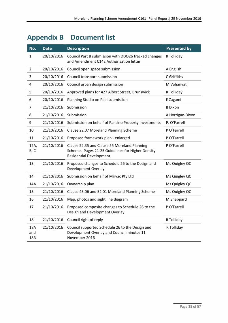
Moreland Planning Scheme Amendment C161 Panel Report 29 November 2016
Page 35 of 57
Appendix B Document list
No. Date Description Presented by
1 20/10/2016 Council Part B submission with DDO26 tracked changes and Amendment C142 Authorisation letter
R Tolliday
2 20/10/2016 Council open space submission A English
3 20/10/2016 Council transport submission C Griffiths
4 20/10/2016 Council urban design submission M Vahanvati
5 20/10/2016 Approved plans for 427 Albert Street, Brunswick R Tolliday
6 20/10/2016 Planning Studio on Peel submission E Zagami
7 21/10/2016 Submission B Dixon
8 21/10/2016 Submission A Horrigan‐Dixon
9 21/10/2016 Submission on behalf of Pansino Property Investments P. O’Farrell
10 21/10/2016 Clause 22.07 Moreland Planning Scheme P O’Farrell
11 21/10/2016 Proposed framework plan ‐ enlarged P O’Farrell
12A, B, C
21/10/2016 Clause 52.35 and Clause 55 Moreland Planning Scheme. Pages 21‐25 Guidelines for Higher Density Residential Development
P O’Farrell
13 21/10/2016 Proposed changes to Schedule 26 to the Design and Development Overlay
Ms Quigley QC
14 21/10/2016 Submission on behalf of Mirvac Pty Ltd Ms Quigley QC
14A 21/10/2016 Ownership plan Ms Quigley QC
15 21/10/2016 Clause 45.06 and 52.01 Moreland Planning Scheme Ms Quigley QC
16 21/10/2016 Map, photos and sight line diagram M Sheppard
17 21/10/2016 Proposed composite changes to Schedule 26 to the Design and Development Overlay
P O’Farrell
18 21/10/2016 Council right of reply R Tolliday
18A and 18B
21/10/2016 Council supported Schedule 26 to the Design and Development Overlay and Council minutes 11 November 2016
R Tolliday

Moreland Planning Scheme Amendment C161 Panel Report 29 November 2016
Page 36 of 57
Appendix C Schedule 26 to the Design and Development Overlay (21 October 2016)
26 SCHEDULE [26] TO THE DESIGN AND DEVELOPMENT OVERLAY
Shown on the planning scheme map as DDO[26].
395-429 Albert Street, Brunswick - Albert Street Urban Renewal Precinct
1.0 Design objectives
To support a transition to quality medium density residential development to create a new mid rise built form character with a mandatory maximum height of six (6) storeys.
To ensure development fronting Albert Street and Clifton Park creates a pedestrian scale character of up to four (4) storeys.
To ensure built form at the western interface of the precict is designed to scale down to respond to the lower scale and heritage significance of existing dwellings.
To establish visual and public pedestrian connections between Albert Street and Clifton Park.
To ensure site design, building frontages, design articulation and internal layout achieve a high quality interface with and surveillance of the public realm, including Albert Street, Clifton Park and any public and communal spaces and pathways created within the precinct.
To ensure building massing, separation and orientation optimises daylight access to living rooms and open space areas of new dwellings, and solar access to communal and public spaces and pathways within the precinct.
To ensure building siting, separation and orientation optimises park views for new dwellings and key pedestrian paths.
To ensure future residents are provided with a high level of internal amenity.
To ensure a mix of dwelling types are provided in the precinct, including a mix of 1, 2 and 3+ bedroom dwellings.
To encourage site consolidation to improve overall design and development outcomes.
To ensure equitable development potential across the precinct.
To prioritise pedestrian and cycle movements over vehicle movements, within the precinct and along Albert Street.
To ensure landscape design enhances the new character to be created in the precinct and integrates the development into the surrounding parkland context.
2.0 Application requirements
An application for development must include, having regard to the particular stage of development, the following information to the satisfaction of the responsible authority:
Confirmation of the following upgrade works/actions to be confirmed by a section 173 Agreement or other suitable guarantee, including the timing for these items. The cost of these upgrades works/actions are to be paid for by the developer and considered in addition to any
--/--/20-- C--
--/--/20-- C--
--/--/20-- C--

Moreland Planning Scheme Amendment C161 Panel Report 29 November 2016
Page 37 of 57
developer contribution made under clause 45.06 (DCPO) Schedule 1 and clause 52.01 (open space contribution) of the Planning Scheme:
o When and how any upgrades to both sides of Albert Street, including the undergrounding or bundling of powerlines and street tree planting, will be achieved.
o When and how any upgrades to Clifton Park will be achieved, including:
The need for any additional infrastructure to manage conflicts resulting from the ‘active use’ of the sports grounds in Clifton Park (e.g. protective nets behind goal posts),
The construction of the public path along the interface with Clifton Park, including tree planting.
The creation of a ‘paper road’ to delineate private land from public land and provide legal pedestrian access, where needed, to new dwellings fronting the park.
An Urban Design Report, prepared by an urban design professional or architect, addressing how the development addresses the Design Objectives set out at Clause 1.0 above and the Buildings and Works requirements set out at Clause 3.0 below, including how the proposal integrates with any developed portions of the precinct and yet to be developed portions to ensure the internal amenity for occupiers of proposed dwellings is addressed and to identify the reasonable development opportunities of adjoining sites.
A preliminary site assessment prepared by a suitably qualified environmental professional demonstrating that there has been no contamination risk found that could not be managed that may prevent the proposed use and development, the nature of any contamination risk and specifying the name and qualifications of the author of the report.
A Traffic Engineering Report confirming the suitability of traffic and access arrangements for each stage of development, including for waste collection, having regard to the relevant requirements set out at clause 3.0 below.
A Landscape Design Report detailing the planting strategy, including proposed plant species, associated with each stage of development including an assessment of the impact on any existing trees.
A Sustainable Management Plan (SMP) prepared by a suitably qualified person that demonstrates how the development achieves best practice in environmentally sustainable development from the design stage through to construction and operation, as required by clause 22.08 of the Municipal Strategic Statement (Environmentally Sustainable Development Local Policy).
An Acoustic Engineering Report prepared by a suitably qualified person demonstrating the use of suitable materials and building treatments to ensure appropriate acoustic mitigation from any existing noise sources within and external to the precinct.
An Affordable Housing Report prepared by a suitably qualified person, detailing how the development will incorporate the affordable housing strategies set out at clause 21.03 of the Municipal Strategic Statement (Strategy 8.2).
An Accessibility Report prepared by a qualified and accredited accessibility consultant detailing how the development will incorporate the adaptable and visitable design features, set out at clause 21.03 of the Municipal Strategic Statement (Strategies 9.1 and 9.2) and Universal Design of communal and public areas and pathways.

Moreland Planning Scheme Amendment C161 Panel Report 29 November 2016
Page 38 of 57
3.0 Buildings and works
No permit is required to:
Construct or extend one dwelling on a lot of more than 300 square metres. This exemption does not apply to:
- Construct a dwelling if there is at least one dwelling existing on the lot;
- Construct or extend a dwelling if there are two or more dwellings on the lot;
- Construct or extend a dwelling if it is on common property; and
- Construct or extend a front fence within 3 metres of a street if the fence is associated with 1 or more dwellings on a lot or a residential building, and the fence exceeds the maximum height specified in Clause 55.06-2.
Construct or carry out works normal to a dwelling.
Construct or extend an outbuilding (other than a garage or carport) on a lot provided the gross floor area of the outbuilding does not exceed 10 square metres and the maximum building height is not more than 3 metres above ground level.
Built Form
For the purpose of this schedule:
Four (4) storeys means a maximum height of 13.5 metres; Six (6) storeys means a maximum height of 19 metres.
The preferred built form layout is indicated in Figure 2.
Development fronting Clifton Park should not exceed four (4) storeys.
Development fronting Albert Street should not exceed four (4) storeys.
Development must not exceed an overall maximum height of six (6) storeys.
A permit cannot be granted to exceed the maximum height of six (6) storeys.
Taller buildings above four (4) storeys should be set back from the four storey podium at the Albert Street and Clifton Park interfaces and from existing dwellings adjacent to the precinct, and be designed to be visually subservient when viewed from Clifton Park, Albert Street and the rear of properties fronting Albert and Pearson Streets. Balconies should not encroach into upper level setbacks.
Buildings must be designed and oriented to optimise daylight access to new dwellings and solar access to communal and public spaces across the precinct.
Building siting, separation and orientation should optimise park views for new dwellings and key pedestrian paths.
Development should avoid creating a continuous wall of built form along the Clifton Park and Albert Street frontages by creating physical breaks between buildings.
Visual connections between Albert Street and Clifton Park should be provided, primarily through a new network of public streets and/or pedestrian paths through the site and through breaks between buildings.
Development must comply with the Moreland Apartment Design Code 2015, in particular the building separation and internal amenity objectives and standards.
A permit may be granted to exceed the preferred heights, other than the maximum six (6) storeys if the following criteria can be met, to the satisfaction of the Responsible Authority:
--/--/20-- C--

Moreland Planning Scheme Amendment C161 Panel Report 29 November 2016
Page 39 of 57
· Demonstrate how the development meets the objectives of this schedule.
· The development is of exemplary design quality (i.e. substantially superior to an acceptable design), particularly with regard to the buildings external presentation and ground level street and park interfaces.
· How the visual impacts of the development on existing dwellings and parkland are mitigated through the design response.
· Any additional height exceeding the preferred heights must also provide specific additional benefits to the community, including:
‐ Excellent ESD performance over and above that required by clause 22.08 (ESD Local Policy); or
‐ Additional contributions to public open space over and above that required by clause 52.01 (Public Open Space Contribution); or
‐ The provision of a social housing component, to be managed by a registered housing association or similar organisation.
Albert Street Interfaces
Development must create active frontages and dwelling entries at ground floor and primary outlooks at all levels to provide for passive surveillance and activation of Albert Street.
A minimum 3 metre landscaped setback to Albert Street should be provided. A lesser setback may be provided if commercial or other non-residential uses are proposed at ground floor. Balconies should not encroach into the setback.
Development must provide for the upgrade of the Albert Street footpath and street tree planting (design details to be resolved at the planning permit application stage).
Access and loading areas for any retail or commercial uses should be from the side or rear of buildings fronting Albert Street.
Clifton Park Interfaces
Buildings and private open space should be clearly separated from the boundary of Clifton Park by a public path, as per Figure 1, to provide a clear delineation between the public and private realm. The path must be shared across public and private land in accordance with Figure 1 and cross-sections A, B and C.
A 3 metre landscaped setback to Clifton Park should be provided, as shown in cross-sections A, B and C. The setback may be reduced if commercial or other non-residential uses are proposed at ground floor. Balconies should not encroach into the setback.
Development must create active frontages and should create dwelling entries at ground floor and primary outlooks at all levels to provide for casual surveillance and activation of Clifton Park.
Western Interface
The siting and setbacks of any buildings on the western boundary should comply with Clause 55 Standard B17.
Note: Laneways that exist along the rear boundary of adjacent properties should be counted as part of the setback envelope
Buildings should minimise the number of setbacks to upper floors to avoid a ‘wedding cake’ built form outcome.
The Primary Public Path shown in Figures 1 and 2 should be shared across the properties at 427 and 429 Albert Street and allow for a minimum 3 metre wide public path which is open to the sky.
Development which fronts the Primary Public Path should be setback and designed to create active frontages to this link.

Moreland Planning Scheme Amendment C161 Panel Report 29 November 2016
Page 40 of 57
Development should facilitate the creation of internal roads that will provide access to multiple stages of development to minimise the number of individual accessways and crossovers to Albert Street.
Land parcels should be consolidated or designed to incorporate shared vehicle access to minimise the number of vehicle crossovers to Albert Street in accordance with the preferred vehicle access points shown in Figure 2.
Any internal roads, laneways and pedestrian paths intended to be vested in Council must be designed and constructed in accordance with Moreland City Council standards (including dimensions) and where appropriate make provision for two-way vehicular traffic, vehicles associated with waste management, safe pedestrian access for all, bicycles and tree planting.
Any above-basement car parking areas must be screened from view of the street and park and should be sleeved by dwellings or other uses.
All development must have legal access that does not rely on public land.
The existing laneway connecting to Pearson Street at the west of the precinct should be considered for pedestrian access into the precinct, as shown in Figure 2. No vehicle access should be provided from this laneway into the precinct.
Landscaping
Landscape design should contribute significantly to the new character to be created in the precinct and integrate the precinct into the surrounding parklands context.
The landscape design should:
Soften the visual impact of buildings on Clifton Park and the public path; Maintain any existing significant trees; Contribute to reduction of the urban heat island effect; Provide for summer shading and access to winter sun; Incorporate green rooves and walls; Provide for deep soil planting where possible. If deep soil planting is not possible due
to contamination, adequate above ground allowance must be made to accommodate significant vegetation and landscaping;
Incorporate water sensitive urban design.
The landscape design should include any associated street and park landscaping in Albert Street and Clifton Park to be delivered by the development, including trees in the park as shown in cross-sections A, B and C and street trees along Albert Street immediately adjacent to the precinct.
Equitable development potential
New development must be designed to have regard to the reasonable development potential of adjacent sites in the precinct, including consideration of shared accessways and opportunity for public easements, as well as adequate building separation distances.
4.0 Subdivision
Applications that do not support the development objectives of this schedule are discouraged.
The consolidation of narrow lots to encourage better development is encouraged.
Except for the consolidation of existing lots or the realignment of existing boundaries, any application to subdivide land must include a Plan of Subdivision showing public paths set aside as road and vested in council generally in accordance with the plan at Figure 1.
--/--/20-- C--

Moreland Planning Scheme Amendment C161 Panel Report 29 November 2016
Page 41 of 57
5.0 Exemption from Notice and Review
None.
6.0 Decision Guidelines
Before deciding on an application, the responsible authority must consider:
The Moreland Apartment Design Code (2015)
7.0 Reference Documents
None
--/--/20-- C--
--/--/20-- C--
--/--/20-- C--

Moreland Planning Scheme Amendment C161 Panel Report 29 November 2016
Page 42 of 57
Figure 1 – Framework Plan

Moreland Planning Scheme Amendment C161 Panel Report 29 November 2016
Page 43 of 57
Figure 2 – Indicative Built Form Plan
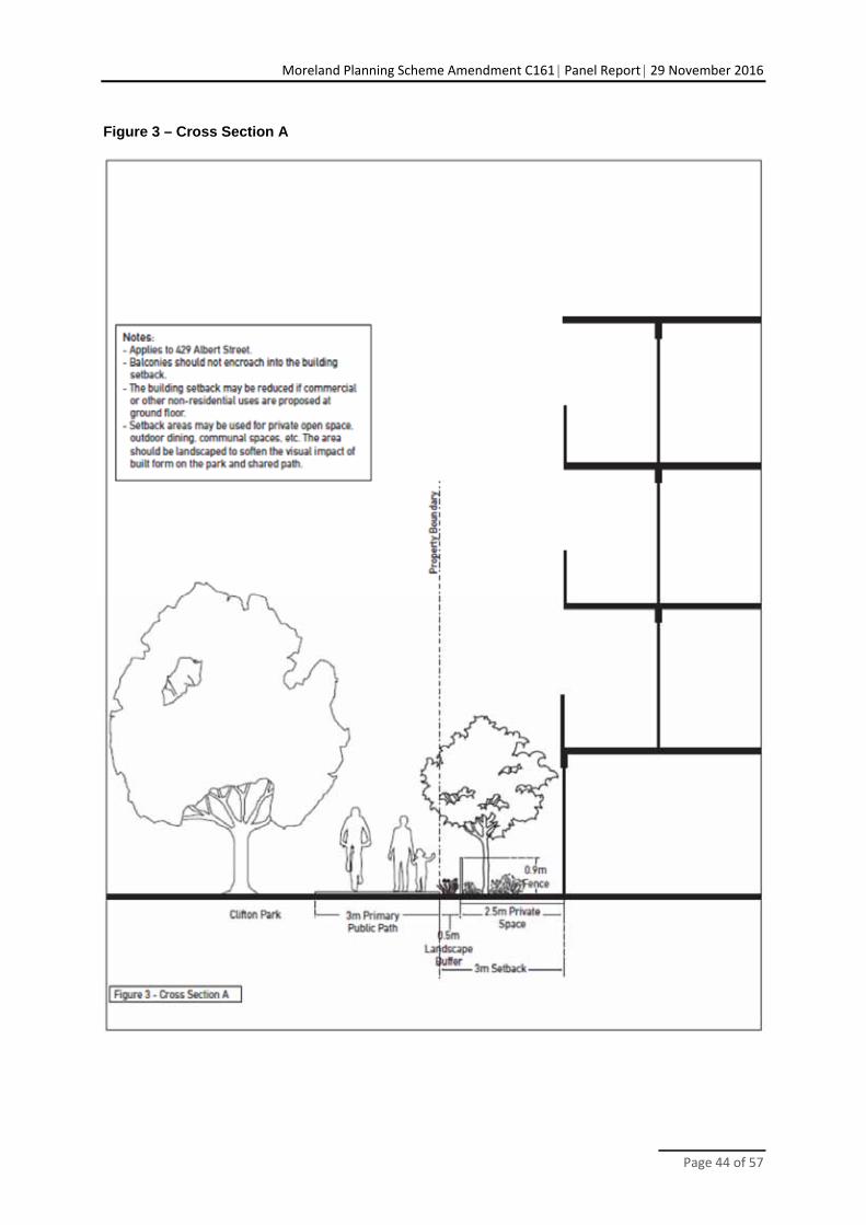
Moreland Planning Scheme Amendment C161 Panel Report 29 November 2016
Page 44 of 57
Figure 3 – Cross Section A

Moreland Planning Scheme Amendment C161 Panel Report 29 November 2016
Page 45 of 57
Figure 4 – Cross Section B

Moreland Planning Scheme Amendment C161 Panel Report 29 November 2016
Page 46 of 57
Figure 5 – Cross Section C

Moreland Planning Scheme Amendment C161 Panel Report 29 November 2016
Page 47 of 57
Appendix D Schedule 26 to the Design and Development Overlay supported by the Panel
26 SCHEDULE [26] TO THE DESIGN AND DEVELOPMENT OVERLAY
Shown on the planning scheme map as DDO[26].
395-429 Albert Street, Brunswick - Albert Street Urban Renewal Precinct
1.0 Design objectives
To support a transition to quality medium density residential development to create a new mid rise built form character with a mandatory maximum height of six (6) storeys.
To ensure development fronting Albert Street and Clifton Park creates a pedestrian scale character of up to four (4) storeys.
To ensure built form at the western interface of the precinct is designed to scale down and provide a separation to respond to the lower scale and heritage significance of existing dwellings.
To establish visual and public pedestrian connections between Albert Street and Clifton Park.
To ensure site design, building frontages, design articulation and internal layout achieve a high quality interface with and surveillance of the public realm, including Albert Street, Clifton Park and any public and communal spaces and pathways created within the precinct.
To ensure building massing, separation and orientation optimises daylight access to living rooms and open space areas of new dwellings, and solar access to communal and public spaces and pathways within the precinct.
To ensure building siting, separation and orientation optimises park views for new dwellings and key pedestrian paths.
To ensure future residents are provided with a high level of internal amenity.
To provide ensure a mix of dwelling types are provided in the precinct, including a mix of 1, 2 and 3+ bedroom dwellings.
To encourage site consolidation to improve overall design and development outcomes.
To ensure equitable development potential across the precinct.
To prioritise pedestrian and cycle movements over vehicle movements, within the precinct in order to facilitate connection and along Albert Street.
To ensure landscape design enhances the new character to be created in the precinct and integrates the development into the surrounding parkland context.
--/--/20-- C--
--/--/20-- C--

Moreland Planning Scheme Amendment C161 Panel Report 29 November 2016
Page 48 of 57
2.0 Application requirements
An application for development must include, where appropriate, having regard to the particular stage of development, the following information to the satisfaction of the responsible authority:
Confirmation of the following upgrade works/actions to be confirmed by a section 173 Agreement or other suitable guarantee, including the timing for these items. The cost of these upgrades works/actions are to be paid for by the developer and considered in addition to any developer contribution made under clause 45.06 (DCPO) Schedule 1 and clause 52.01 (open space contribution) of the Planning Scheme:
o When and how any upgrades to both sides of Albert Street, including the undergrounding or bundling of powerlines and street tree planting, will be achieved.
o When and how any upgrades to Clifton Park will be achieved, including:
Tthe need for any additional infrastructure to manage conflicts resulting from the ‘active use’ of the sports grounds in Clifton Park (e.g. protective nets behind goal posts).
Tthe construction of the public path along the interface with Clifton Park, including tree planting.
Tthe creation of a ‘paper road’ to delineate private land from public land and provide legal pedestrian access, where needed, to new dwellings fronting the park.
An Urban Design Report, prepared by an urban design professional or architect, addressing how the development addresses the Design Objectives set out at Clause 1.0 above and the Buildings and Works requirements set out at Clause 3.0 below, including how the proposal integrates with any developed portions of the precinct and yet to be developed portions to ensure the internal amenity for occupiers of proposed dwellings is addressed and to identify the reasonable development opportunities of adjoining sites.
A preliminary site assessment prepared by a suitably qualified environmental professional demonstrating that there has been no contamination risk found that could not be managed that may prevent the proposed use and development, the nature of any contamination risk and specifying the name and qualifications of the author of the report.
A Traffic Engineering Report confirming the suitability of traffic and access arrangements for each stage of development, including for waste collection, having regard to the relevant requirements set out at clause 3.0 below.
A Landscape Design Report detailing the planting strategy, including proposed plant species, associated with each stage of development including an assessment of the significance of existing trees and potential to retain them impact on any existing trees.
A Sustainable Management Plan (SMP) prepared by a suitably qualified person that demonstrates how the development achieves best practice in environmentally sustainable development from the design stage through to construction and operation, as required by clause 22.08 of the Municipal Strategic Statement (Environmentally Sustainable Development Local Policy).
An Acoustic Engineering Report prepared by a suitably qualified person demonstrating the use of suitable materials and building treatments to ensure appropriate acoustic mitigation from any existing noise sources within and external to the precinct.
An Affordable Housing Report prepared by a suitably qualified person, detailing how the development will incorporate the affordable housing strategies set out at clause 21.03 of the Municipal Strategic Statement (Strategy 8.2).
An Accessibility Report prepared by a qualified and accredited accessibility consultant detailing how the development will incorporate the adaptable and visitable design features,
--/--/20-- C--

Moreland Planning Scheme Amendment C161 Panel Report 29 November 2016
Page 49 of 57
set out at clause 21.03 of the Municipal Strategic Statement (Strategies 9.1 and 9.2) and Universal Design of communal and public areas and pathways.
3.0 Buildings and works
No permit is required to:
Construct or extend one dwelling on a lot of more than 300 square metres. This exemption does not apply to:
- Construct a dwelling if there is at least one dwelling existing on the lot;
- Construct or extend a dwelling if there are two or more dwellings on the lot;
- Construct or extend a dwelling if it is on common property; and
- Construct or extend a front fence within 3 metres of a street if the fence is associated with 1 or more dwellings on a lot or a residential building, and the fence exceeds the maximum height specified in Clause 55.06-2.
Construct or carry out works normal to a dwelling.
Construct or extend an outbuilding (other than a garage or carport) on a lot provided the gross floor area of the outbuilding does not exceed 10 square metres and the maximum building height is not more than 3 metres above ground level.
4.0 Requirements
Built Form
For the purpose of this schedule:
Four (4) storeys means a maximum height of 135 metres; Eight six (68) storeys means a maximum height of 1928 metres.
The preferred built form layout is indicated in Figure 2.
Development fronting Clifton Park should not exceed four (4) storeys.
Development fronting Albert Street should not exceed four (4) storeys.
Development should must not exceed an overall maximum height of eight six (68)storeys.
A permit cannot be granted to exceed the maximum height of six (6) storeys.
Taller buildings above four (4) storeys should be set back from the four storey podium at the Albert Street and Clifton Park interfaces and from existing dwellings adjacent to the precinct, and be designed to be visually recessive subservient when viewed from Clifton Park, Albert Street and the rear of properties fronting Albert and Pearson Streets. Balconies should not encroach into upper level setbacks.
Buildings must be designed and oriented to optimise daylight access to new dwellings and solar access to communal and public spaces across the precinct.
Building siting, separation and orientation should optimise park views for new dwellings and public paths as indicated on Figure 1 key pedestrian paths.
Development should avoid creating a continuous wall of built form along the Clifton Park and Albert Street frontages by creating physical breaks between buildings.
Visual connections between Albert Street and Clifton Park should be provided, primarily through a new network of public streets and/or pedestrian paths through the site and through breaks between buildings.
--/--/20-- C--

Moreland Planning Scheme Amendment C161 Panel Report 29 November 2016
Page 50 of 57
Development should provide for a mix of dwelling types including 1, 2 and 3 bebdroom dwellings.
Development must comply with the Moreland Apartment Design Code 2015, in particular the building separation and internal amenity objectives and standards.
Built form that exceeds 8 storeys A permit may be granted to exceed must meet the preferred heights, other than the maximum six (6) storeys if the following criteria can be met, to the satisfaction of the Responsible Authority:
Demonstrate how the development meets the objectives of this schedule. The development is of exemplary design quality (i.e. substantially superior to an
acceptable design), particularly with regard to the buildings external presentation and ground level street and park interfaces.
How the visual impacts of the development on existing dwellings and parkland are mitigated through the design response.
· Any additional height exceeding the preferred heights must also provide specific additional benefits to the community, including:
‐ Excellent ESD performance over and above that required by clause 22.08 (ESD Local Policy); or
‐ Additional contributions to public open space over and above that required by clause 52.01 (Public Open Space Contribution); or
‐ The provision of a social housing component, to be managed by a registered housing association or similar organisation.
Albert Street Interfaces
Development must create active frontages and dwelling entries at ground floor and primary outlooks at all levels to provide for passive surveillance and activation of Albert Street.
A minimum 3 metre landscaped setback to Albert Street should be provided. A lesser setback may be provided if commercial or other non-residential uses are proposed at ground floor. Balconies should not encroach into the setback.
Development must provide for the upgrade of the Albert Street footpath and street tree planting immediately adjacent to the precinct (design details to be resolved at the planning permit application stage).
Access and loading areas for any retail or commercial uses should be from the side or rear of buildings fronting Albert Street.
Clifton Park Interfaces
Buildings and private open space should be clearly separated from the boundary of Clifton Park by a public path, as per Figure 1, to provide a clear delineation between the public and private realm. The path should must be provided on public land shared across public and private land in accordance with Figure 1 and cross-sections A, and B and C.
A 3 metre landscaped setback to Clifton Park should be provided, as shown in cross-sections A, and B and C. The setback may be reduced if commercial or other non-residential uses are proposed at ground floor. Balconies should not encroach into the setback.
Development must create active frontages and should create dwelling entries at ground floor and primary outlooks at all levels to provide for casual surveillance and activation of Clifton Park.
Western Residential Interface
The siting and setbacks of any buildings on the western boundary should comply with Clause 55 Standard B17, Standard B21 and Standard B22.

Moreland Planning Scheme Amendment C161 Panel Report 29 November 2016
Page 51 of 57
Any new buildings along the western interface of the precinct should provide adequate separation and landscaping to recognise the proximity of the heritage residential properties to the west.
Note: Laneways that exist along the rear boundary of adjacent properties should be counted as part of the setback envelope
Buildings should minimise the number of setbacks to upper floors to avoid a ‘wedding cake’ built form outcome.
Circulation, Access and Parking
Development must provide for the public paths shown in Figure 1.
The Primary Public Path shown in Figures 1 and 2 must be provided and should generally be shared across the properties at 427 and 429 Albert Street and allow for a minimum 3 metre wide public path which is open to the sky.
Development which fronts the Primary Public Path should be setback and designed to create active frontages to this link.
Development should facilitate the creation of internal roads that will provide access to multiple stages of development to minimise the number of individual accessways and crossovers to Albert Street.
Land parcels should be consolidated or designed to incorporate shared vehicle access to minimise the number of vehicle crossovers to Albert Street in accordance with the preferred vehicle access points shown in Figure 2.
Any internal roads, laneways and pedestrian paths intended to be vested in Council must be designed and constructed in accordance with Moreland City Council standards (including dimensions) and where appropriate make provision for two-way vehicular traffic, vehicles associated with waste management, safe pedestrian access for all, bicycles and tree planting.
Any above-basement car parking areas must be screened from view of the street and park and should be sleeved by dwellings or other uses.
All development must have legal access to a road or a ‘paper road’ that does not rely on public land.
The existing laneway connecting to Pearson Street at the west of the precinct should be considered for pedestrian access into the precinct as shown in Figure 2. No vehicle access should be provided from this laneway into the precinct.
Landscaping
Landscape design should contribute significantly to the new character to be created in the precinct and integrate the precinct into the surrounding parklands context.
The landscape design should, where appropriate:
Soften the visual impact of buildings on Clifton Park and the public path; Maintain any existing significant trees; Contribute to reduction of the urban heat island effect; Provide for summer shading and access to winter sun; Incorporate green rooves and walls; Provide for deep soil planting where possible. If deep soil planting is not possible due
to contamination, adequate above ground allowance must be made to accommodate significant vegetation and landscaping; and
Incorporate water sensitive urban design.
The landscape design should include any associated street and park landscaping in Albert Street and Clifton Park to be delivered by the development, including trees in the park as
Moreland Planning Scheme Amendment C161 Panel Report 29 November 2016
Page 52 of 57
shown in cross-sections A, and B and C and street trees along Albert Street immediately adjacent to the precinct.
Equitable development potential
New development must be designed to have regard to the reasonable development potential of adjacent sites in the precinct, including consideration of shared accessways and opportunity for public easements, as well as adequate building separation distances.
4.0 Subdivision
Applications that do not support the development objectives of this schedule are discouraged.
The consolidation of narrow lots to encourage better development is encouraged.
Except for the consolidation of existing lots or the realignment of existing boundaries, any application to subdivide land must include a Plan of Subdivision showing public paths set aside as road and vested in cCouncil generally in accordance with the plan at Figure 1.
5.0 Exemption from Notice and Review
None.
6.0 Decision Guidelines
Before deciding on an application, the responsible authority must consider:
The Moreland Apartment Design Code (2015)
Council to provide more detailed decision guidelines that respond to the design objectives
7.0 Reference Documents
None.
--/--/20-- C--
--/--/20-- C--
--/--/20-- C--
--/--/20-- C--

Moreland Planning Scheme Amendment C161 Panel Report 29 November 2016
Page 53 of 57
Figure 1 – Framework Plan

Moreland Planning Scheme Amendment C161 Panel Report 29 November 2016
Page 54 of 57
Figure 2 – Indicative Built Form Plan20
20 Council is to delete the vehicle access points – see Recommendation 1(j).

Moreland Planning Scheme Amendment C161 Panel Report 29 November 2016
Page 55 of 57
Figure 3 – Cross Section A

Moreland Planning Scheme Amendment C161 Panel Report 29 November 2016
Page 56 of 57
Figure 4 – Cross Section B

Moreland Planning Scheme Amendment C161 Panel Report 29 November 2016
Page 57 of 57
Figure 5 – Cross Section C