T E R R A S A N C T A R E T R E A T C E N T E R IMPACT REPORT
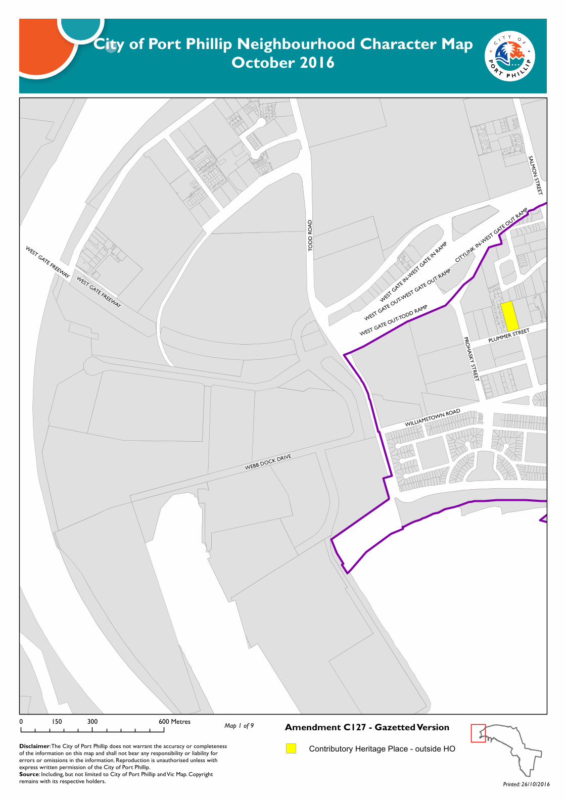
WEST GATE FREEWAY
WILLIAMSTOWN ROAD
TODD
ROAD
SALMON STREET
PROHASKY STREET
WEST GATE IN
-WEST GATE IN
RAMP
WEBB DOCK DRIVE
WEST GATE OUT-TODD RAMPWEST GATE OUT-WEST GATE OUT RAMP
PLUMMER STREET
CITYLINK IN-WEST GATE OUT RAMP
WEST GATE FREEWAY
City of Port Phillip Neighbourhood Character MapOctober 2016
Amendment C127 - Gazetted Version0 300 600150 Metres
Disclaimer: The City of Port Phillip does not warrant the accuracy or completeness of the information on this map and shall not bear any responsibility or liability for errors or omissions in the information. Reproduction is unauthorised unless with express written permission of the City of Port Phillip.Source: Including, but not limited to City of Port Phillip and Vic Map. Copyright remains with its respective holders. Printed: 26/10/2016
Map 1 of 9
Contributory Heritage Place - outside HO

WEST GATE FREEWAY
WILLIAMSTOWN ROADPLUMMER STREET
INGLES STREET
GRAHAM STREET
CITYLINK IN-LORIMER RAMP
WEST GATE OUT-CITYLINK OUT RAMPCITYLINK
BRIDGE STREET
WEST GATE IN-KINGS RAMP
BAY ST
REET
SALMON STREET
LORIMER STREET
KINGS-WEST GATE OUT RAMP
BEACH STREET
CITYLINK
BRIDGE STREET
WEST GATE FREEWAY
City of Port Phillip Neighbourhood Character MapOctober 2016
Amendment C127 - Gazetted Version0 300 600150 Metres
Disclaimer: The City of Port Phillip does not warrant the accuracy or completeness of the information on this map and shall not bear any responsibility or liability for errors or omissions in the information. Reproduction is unauthorised unless with express written permission of the City of Port Phillip.Source: Including, but not limited to City of Port Phillip and Vic Map. Copyright remains with its respective holders. Printed: 26/10/2016
Map 2 of 9
Contributory Heritage Place - outside HO
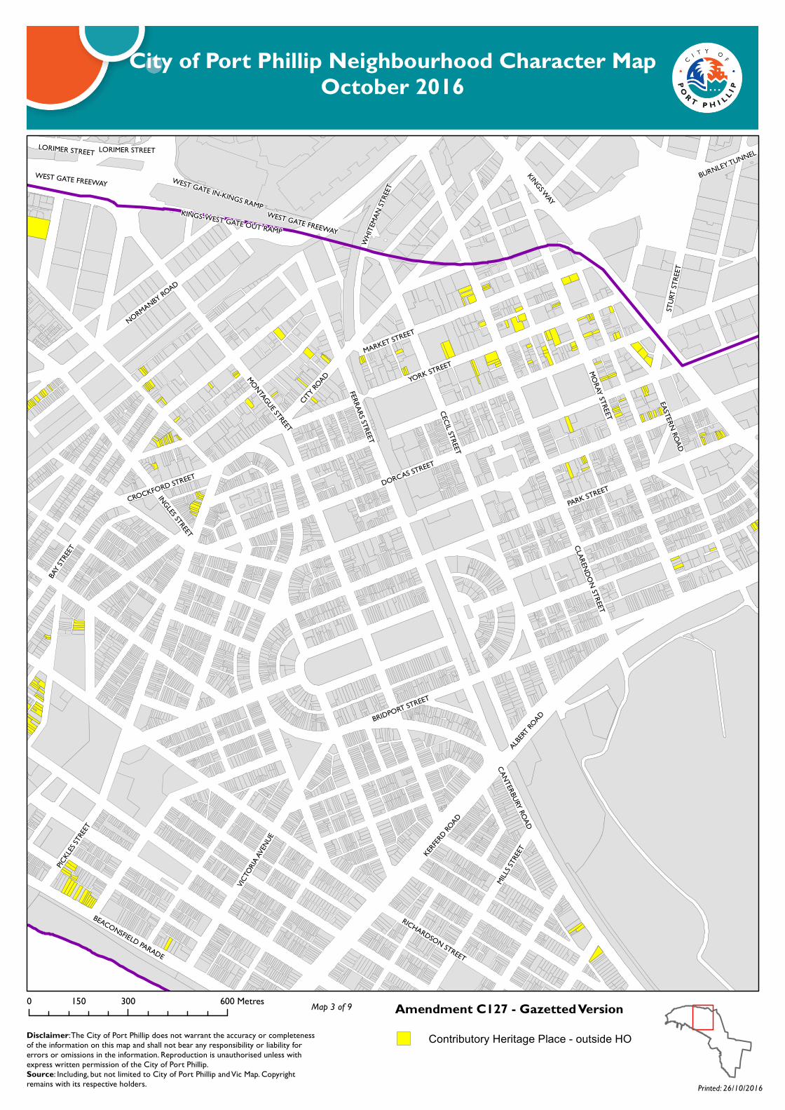
CITY RO
AD MORAY STREET
DORCAS STREET
PICKL
ES STR
EET
PARK STREET
WEST GATE FREEWAY
FERRARS STREET
CLARENDON STREET
ALBERT
ROAD
WEST GATE IN-KINGS RAMPKINGS-WEST GATE OUT RAMP
KERFERD
ROAD
YORK STREET
VICTO
RIA AV
ENUE
CANTERBURY ROAD
NORMANBY ROAD
BURNLEY TUNNEL
BEACONSFIELD PARADE
BAY ST
REET
KINGS WAY
BRIDPORT STREET
CROCKFORD STREET
EASTERN ROAD
STUR
T STR
EET
WHIT
EMAN
STRE
ET
LORIMER STREET
MARKET STREET
INGLES STREET
CECIL STREET
RICHARDSON STREET
MONTAGUE STREETMIL
LS STR
EET
WEST GATE FREEWAY
LORIMER STREET
City of Port Phillip Neighbourhood Character MapOctober 2016
Amendment C127 - Gazetted Version0 300 600150 Metres
Disclaimer: The City of Port Phillip does not warrant the accuracy or completeness of the information on this map and shall not bear any responsibility or liability for errors or omissions in the information. Reproduction is unauthorised unless with express written permission of the City of Port Phillip.Source: Including, but not limited to City of Port Phillip and Vic Map. Copyright remains with its respective holders. Printed: 26/10/2016
Map 3 of 9
Contributory Heritage Place - outside HO
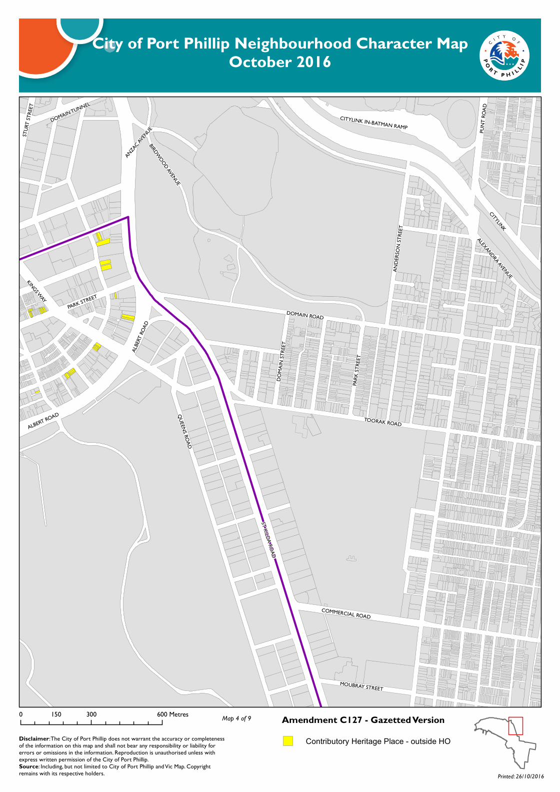
ST KILDA ROAD
DOMAIN ROAD
CITYLINK
QUEENS ROAD
TOORAK ROAD
KINGS WAY
ALEXANDRA AVENUE
BIRDWOOD AVENUE
ALBERT ROAD
ANDE
RSON
STRE
ET
PARK
STRE
ET
DOMA
IN ST
REET
MOUBRAY STREET
DOMAIN TUNNEL
STUR
T STR
EET
CITYLINK IN-BATMAN RAMP PUNT
ROAD
COMMERCIAL ROAD
ANZAC AV
ENUE
ALBE
RT RO
AD
PARK STREET
City of Port Phillip Neighbourhood Character MapOctober 2016
Amendment C127 - Gazetted Version0 300 600150 Metres
Disclaimer: The City of Port Phillip does not warrant the accuracy or completeness of the information on this map and shall not bear any responsibility or liability for errors or omissions in the information. Reproduction is unauthorised unless with express written permission of the City of Port Phillip.Source: Including, but not limited to City of Port Phillip and Vic Map. Copyright remains with its respective holders. Printed: 26/10/2016
Map 4 of 9
Contributory Heritage Place - outside HO
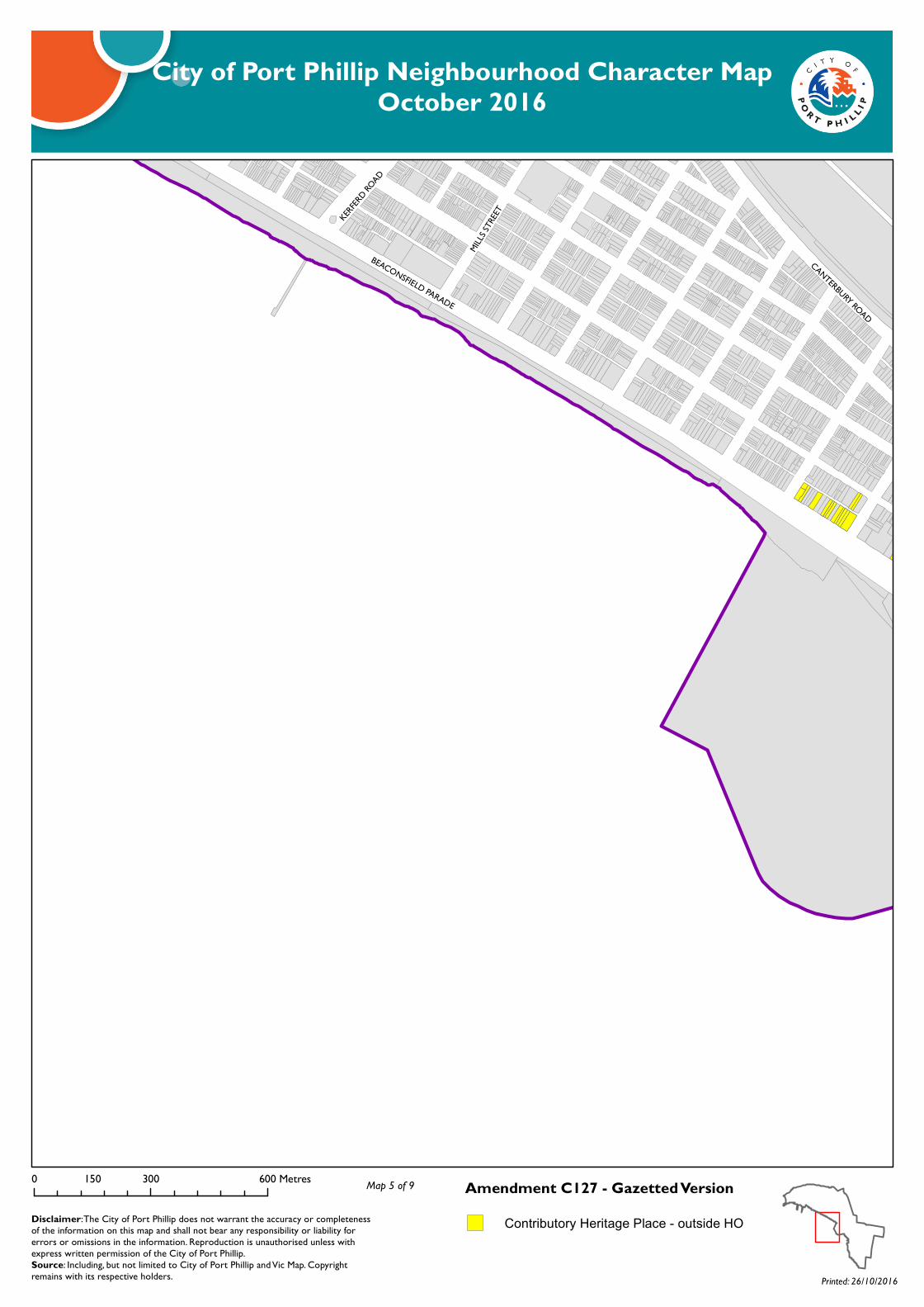
BEACONSFIELD PARADE
MILLS
STREET
CANTERBURY ROAD
KERFERD
ROAD
City of Port Phillip Neighbourhood Character MapOctober 2016
Amendment C127 - Gazetted Version0 300 600150 Metres
Disclaimer: The City of Port Phillip does not warrant the accuracy or completeness of the information on this map and shall not bear any responsibility or liability for errors or omissions in the information. Reproduction is unauthorised unless with express written permission of the City of Port Phillip.Source: Including, but not limited to City of Port Phillip and Vic Map. Copyright remains with its respective holders. Printed: 26/10/2016
Map 5 of 9
Contributory Heritage Place - outside HO

BARK
LY ST
REET
ST KILDA ROAD
CANTERBURY ROAD
CARLISLE STREET
HIGH STREET
FITZROY STREET
QUEENS ROAD
QUEENS WAY
GREY STREET
PUNT
ROAD
JACKA BOULEVARD
THE ESPLANADE
WELLINGTON STREETBEACONSFIELD PARADE
BRIGHTON ROAD
LAKESIDE DRIVE
CAVE
LL ST
REET
GREVILLE STREET
ALMA ROAD
PRINCES STREET
LORNE STREET
UNION STREET
QUEENS WAY
City of Port Phillip Neighbourhood Character MapOctober 2016
Amendment C127 - Gazetted Version0 300 600150 Metres
Disclaimer: The City of Port Phillip does not warrant the accuracy or completeness of the information on this map and shall not bear any responsibility or liability for errors or omissions in the information. Reproduction is unauthorised unless with express written permission of the City of Port Phillip.Source: Including, but not limited to City of Port Phillip and Vic Map. Copyright remains with its respective holders. Printed: 26/10/2016
Map 6 of 9
Contributory Heritage Place - outside HO

ALMA ROAD
HIGH STREET
CHAP
EL ST
REET
ORRO
NG RO
AD
DANDENONG ROAD
WILL
IAMS R
OAD
BALACLAVA ROAD
WES
TBUR
Y STR
EET
CARLISLE STREET
MALVERN ROAD
QUEENS WAY
KING STREET
INKERMAN ROAD
BRIGHTON ROAD
BANG
S STR
EET
HOTH
AM ST
REET
WELLINGTON STREET
INKERMAN STREET
GREVILLE STREETPRINCES CLOSE
QUEENS WAY
DANDENONG ROAD
City of Port Phillip Neighbourhood Character MapOctober 2016
Amendment C127 - Gazetted Version0 300 600150 Metres
Disclaimer: The City of Port Phillip does not warrant the accuracy or completeness of the information on this map and shall not bear any responsibility or liability for errors or omissions in the information. Reproduction is unauthorised unless with express written permission of the City of Port Phillip.Source: Including, but not limited to City of Port Phillip and Vic Map. Copyright remains with its respective holders. Printed: 26/10/2016
Map 7 of 9
Contributory Heritage Place - outside HO
BARK
LY ST
REET
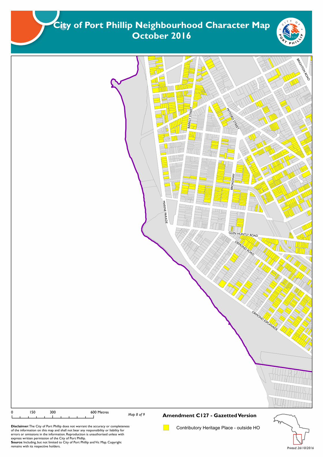
ORMOND ESPLANADE
BROA
DWAY
GLEN HUNTLY ROAD
BRIGHTON ROAD
MITFORD STREET
MARINE PARADE
ORMOND ROAD
City of Port Phillip Neighbourhood Character MapOctober 2016
Amendment C127 - Gazetted Version0 300 600150 Metres
Disclaimer: The City of Port Phillip does not warrant the accuracy or completeness of the information on this map and shall not bear any responsibility or liability for errors or omissions in the information. Reproduction is unauthorised unless with express written permission of the City of Port Phillip.Source: Including, but not limited to City of Port Phillip and Vic Map. Copyright remains with its respective holders. Printed: 26/10/2016
Map 8 of 9
Contributory Heritage Place - outside HO

GLEN HUNTLY ROAD
GLEN EIRA ROAD
BRIGHTON ROAD
HOTH
AM ST
REET
ST KI
LDA
STRE
ET
NEPEAN HIGHWAYRIDDELL PARADE
ST G
EORG
ES RO
AD
ORRO
NG RO
AD
NEW
STRE
ET
COCH
RANE
STRE
ET
RUSDEN STREETORMOND ROAD
BENT AVENUE
CLARENCE STREET
ORMOND ESPLANADE
HEAD STREET
RIDDELL PARADE
NEPEAN HIGHWAY
ORRO
NG RO
AD
City of Port Phillip Neighbourhood Character MapOctober 2016
Amendment C127 - Gazetted Version0 300 600150 Metres
Disclaimer: The City of Port Phillip does not warrant the accuracy or completeness of the information on this map and shall not bear any responsibility or liability for errors or omissions in the information. Reproduction is unauthorised unless with express written permission of the City of Port Phillip.Source: Including, but not limited to City of Port Phillip and Vic Map. Copyright remains with its respective holders. Printed: 26/10/2016
Map 9 of 9
Contributory Heritage Place - outside HO