PLAN ANALYSIS OF THE MEDIEVAL BOROUGHS OF …
240
PLAN ANALYSIS OF THE MEDIEVAL BOROUGHS , .... OF NORTHUMBER LAN D. MARIAN L. WILSON P. H. D . . ".,' Edinburgh 1989 f
Transcript of PLAN ANALYSIS OF THE MEDIEVAL BOROUGHS OF …

PLAN ANALYSIS
OF
THE MEDIEVAL BOROUGHS , ....
OF
NORTHUMBER LAN D. MARIAN L. WILSON
P. H. D . . ".,'
Edinburgh 1989 f

BEST COpy
AVAILABLE Poor text in the original thesis. Some text bound close to the spine. Some images distorted

CONTAINS PULLOUTS

UNIVERSITY OF EDINBURGH ABSTRACT OF THESIS (Regulation 7.9)
In the first part of the first section, earlier work on
boroughs is considered, highlighting the failure to study
morphology. The changing emphasis after 1955 is identified,
stressing the continued focus on individual towns. It is the
failure to consider the basic elements which this research
project is trying to overcome.
The second part of the first section discusses the reasons
why boroughs rather than towns were chosen as the subject of
the study. The common and peculiar features of boroughs are
outlined, indicating the comparative ease with which
Medieval boroughs can be identified in the surviving
documents. Section one concludes with an explanation of why
Northumberland was chosen as the area of study.
Section two involves a discussion of the sources used to
identify the boroughs, including the problem of survival and
the effects of desertion, replanning and industrialisation.
The plans of three boroughs are traced back to 1500 and the
evidence concerning change before then is analysed. A
discussion of the comparability between Medieval and modern
measurements is followed by an explanation of how to achieve
the most accurate measurement of the plots. Finally, each of
the reconstructed boroughs is analysed in detail and
conclusions drawn with regard to the nature and survival of
evidence of planning in Northumberland;s Medieval boroughi.-

Prefac;.~
This research project originated in the apparent ambiguity
which existed between the regular plans of many Medieval
boroughs in Northumberland and the accepted view that, apart
from a minority of planted towns Medieval boroughs were
characterised by a total lack of planning.
Many people have assisted me in my research and to all of
them I extend my thanks but especially:
To His Grace the Duke of Northumberland, for granting me
access to his archives;
The staff at The National Library of Scotland and
Northumberland Record Office;
To Jennie Wilson and Margaret Pattinson, who spent days
measuring burgage plots during the Northumbrian winters,
while all around them questioned their sanity;
To Harry Wilson who transcribed many of the documents;
To Mike Stanley, who showed remarkable patience and control
on occasion, in coping with me as a post graduate student;
To June Sheppard who gave me encouragement to continue when
an apparent impasse had been reached;
And lastly to my family who believe in me and give me every
opportunity and encouragement to do things in my own way.
This thesis was composed by myself and is my own original
work.

PREFACE
CONTENTS
TABLES
MAPS
APPENDICES
SECTION 1
Partl
SECTION 1
Part2
CONTENTS
THE NATURE OF THE PROBLEM
AND THE SUBJECT
The Nature of the Problem
A.Work on boroughs in the
first half of the C20th
and the failure to study
morphology
B.Work since 1955
1.The classification of
form
2.Detailed morphological
analysis of individual
towns(areal and systematic
i
i i
vi
vii
viii
1
1
4
4
studies) 7
1.Plan ,Analysis 7
2.Retrospective Reconstruction 9
3.Archaeological Excavation 10
The Subject of the Study
A.What is a borough?
II
21
21

SECTION 2
PART 1.
B.Why were boroughs
chosen as the subject
of study?
C.What was burgage
tenure?
D.Origins of burgage
tenure.
E.What is a burgage
plot?
F.Why was Northumberland
chosen as the area of
study?
THE METHOD OF STUDY
The Identification of the
Boroughs
A.Problems of the
sources •.
B.Discussion of the
origins of the boroughs
with special reference
to those which have no
surviving evidence of
the original borough
25
26
26
30
30
40
40
plan due to 41
1.Desertion; 42
2.Resitingl 43
3.Replanning in the C19th. 43
iii

SECTION 2
Part 2
SECTION 3.
Part 1.
C.Brief discussion of the
origins of the boroughs
which have surviving
Medieval plan elements.
D.A discussion of the
numerical,temporal and
spatial problems
associated with any
discussion of the
Northumberland boroughs
The Reconstruction of The
Boroughs.
A.The usefulness of
present day plans
B.Other Sources - tithe
awards, surveys, rentals,
court and suit rolls,
deeds and land tax
assessments.
C.The reconstruction of the
borough plans of Alnmouth,
Alnwick, Corbridge, Rothbury
and Warkworth
D.Problems of continuity
before 1500
1.Documentation
2.Archaeological Evidence
THE ANALYSIS OF THE
BOROUGH PLANS.
Influences on Borough Form
IV
44
54
64
64
65
73
76
76
77
83
83

SECTION 3
Par:t 2
Conclusions.
Appendices
Bibliography
A.Town Plans
D.Elements to be compared
1.Churches
2.Castles
3.Market places
4.Street systems and
burgage plots
C.The problem of the
comparison of Medieval and
modern measurements.
D.Measuring Accuracy
The Analysis of Burgage Plots
v
84
87
87
90
90
91
93
101
108
163
165
209

Tables
1. Medieval Boroughs of Northumberland
2. Borough Types found in Northumberland
3. Borough Landowners
4. Boroughs of the Northern Counties
5. Borough Foundations
6. Warkworth Burgage Series.
7. Borough Plan Elements
8. Castles of Northumberland
9. Royal Commision on Weights and
Measures
10.Medieval Church Measurements
11.Aisled House Measurements
12.Warkworth East Row
13.Warworth West Row A
14.Warkworth West Row B
15.Alnmouth East Row Block One
16.Alnmouth East Row Block Two
17.Alnmouth East Row Block Three
18.Alnmouth West Row
19.Rothbury North Row
20.Conzen's Measurements Compared to
the Field Evidence
VI
29
33
35
51
52
82
86
89
94
95
96
116
117
118
130
131
132
133
136
140

1. Market Charters Granted in Medieval
Northumberland 22
2. Northumberland: Relief and Boroughs 28
":" ..;:>. The Boroughs of Northumberland: Land
Ownership at Foundation 34
4. The Boroughs of Northumberland 53 J
5. Warkworth 82 I
6. The Castles of Northumberland 88
7. Warkworth 115
8. Alnmouth· 127
9.The Lands of Edward Gallon 128
10.Mayson's Survey of Alnmouth 129
11.Rothbury 137
12.Alnwic:k 141
13.Corbridge 144
14.Felton 145
15.Haltwhistle 147
16.Harbottle 148
17.Haydon Bridge 150
18.Hexham 151
19.Holy Island 154
20.Morpeth 155
21. Newbiggi n 157
22.Norham 158
23.Wooler 160
vii

1. Documents held in the Muniments Room
at Alnwick Castle
2. Relevant Material from Northumberland
Record Office
3. General Collection of MSS held in
Blackgate Library
4. Allendale MSS
5. Documents used to identify Northumberland
Boroughs
6. References to Borough Status j
7. A Comparison of Field Measurements
by Slater and Wilson in Stratford
8. I.P.M's
9. Maps and Plans
10.Documents Surviving to Reconstruct the
Original Burgage Series in Northumberland
Boroughs
11.Morpeth Court Roll: References to
Conservation of Plot Boundaries
12.Hexham Court Roll: References to
Conservation of Plot Boundaries
13.Rothbury Court Book: References to
Conservation of Plot Boundaries
14.Evidence for the Employment of Land
measures
vi i i
165
170
173
174
175
177
183
184
187
190
191
192
194
195

15.Borough Ownership 900-1600
16.Documentary References to 20' Perch
17.Graphs Showing Burgage Width and
Frequency in Northumberland Boroughs
18.Aerial Photographs
~J
ix
196
197
199
207

SECTION 1
The Nature of the Problem and the Su.pject
Part l-The Nature of the Problem
(A) Work on boroughs in the first half of the C20th and the
failure to study morphplogy
Although English Medieval towns have been studied for a
considerable time by lawyers(l) and local antiquaries up to
the C19th, and later by historical scholars(2) , research has
tended to concentrate on the administrative and/or political
history of individual towns(3). A notable exception to this
tendency was Thomas Mado>:' 'Firma Burgi' published in
1726(4). He and most other scholars virtually ignored
morphology(S) and it is not until fairly recently that this
has been studied seriously(6).From the beginning of this
century, several prominent scholars began to study Medieval
towns. Tait has commented that:
'The C20th began with the brightest prospects for study of early municipal history in this country.... a group of scholars had made a remarkable and unprecedented advance in the solution of the most obscure problems presented by the initial growth of urban life in England'(7).
Among these scholars were F.W.Maitland(8) , A.Ballard(9) and
others(lO), who discussed the origins of the town and the
importance of agricultural links and the origins of .,
institutions and the nature of tenure. Gross(ll), on the
other hand, e>:amined an aspect of the constittional history
in the 'Merchant Gild' and Round(12) and Bateson (13)
illustrated the links with Europe through the cinque ports
and the Laws of Breteuil.
1

Bateson commented in 1900 thata
'By collecting ch~rterG which proposed to found new boroughs in these islands and offered building plots of a fixed size, a means may be afforded to direct inquiry into the outward features of the artificially created towns' (14).
Yet despite this, morphology continued to be neglected as a
subject for study. The only exception is an article by St.
John Hope(15) which began by reiterating Bateson's
observation that:
'the topographical study of our old towns is one of the most fascinating subjects still awaiting investigation' (1b).
The article, however, went on to look at the general form of
the town plan of Ludlow(17). Perhaps the above mentioned
scholars would have turned to the study of morphology but by
1915 they were, with the e>~ption of Round, all dead(18).
'The 1055 to this particular branch of historical research
was irreparable' (19). As a result, there was very little
research of any kind into Medieval towns during the
following 20 years (20) , other than Hemmeon's, 'Burgage
tenure in Medieval England(21) , the second volume of the
borough charters 1923(22) and very detailed studies of
ecclesiastical boroughs by Wooler(23) , Hope-Dodds (24) and
Trenholme(25).
Moreover, (up to 1959), there were few attempts to study
morphology except Page's fourfold classification of
Herefordshire towns(26) and Dickinson's work on the Medieval
towns of Germany and England(27) in which he stated that:
'We are able to discern not merely recurring systems of urban plan but also families of towns which in plan and build have the same basic elements,representing the needs of the community they served, but also the ideas and the traditions of the planners who designed them' (28),
because these settlements have still essentially the same
features of functional layout and size that they had in the
Middle Ages when they originated(29).
The 1950's saw the publication of research on individual
2

towns by Smith(30) and Evans(31), but Stephenson's statement
made in 1933 that 'investigation of local topography has
commonly been carried out in isolation'(32) was still seen
to be true by Mackenzie(33) in 1949:
'One avenue of England ••••• namely boroughs' (34)
evidence has the original
and six years later by Houstan:
not been topography
explored in of early
'little attempt has been made to relate its (the Borough's) distinctive features of organisation and function to its layout' (35) •
3

§ECTION 1
The Nature of the Problem and the Subject
Part 1-The Nature of the Problem
(B)Work §ince 1955
Since 1955 some research has been undertaken into the
morphology of Medieval borough plans in the f~elds of
archaeology as well as historical geography. The work can be
divided into two distinct groups:
1. The ?u~erfi~al classification of form;
2. De1:al led morphol 091 cal anaill,.1 s of i ndi v i_c1ua I towns
and areal and systematic studies.
Dickinson's work (36) on the town plans of East Anglia and
parts of Germany included the pioneering method of looking
at street systems of towns in a given area and assigning
them to one of several form types(37). He argued that the
application of a conception of layout to the design of a
part or whole ,of the plan resulted in three basic form
types: grid; irregular and radial concentric(38). Ennen (39)
in a comprehensive study of Europe concluded that;
'within the vast area of Europe,numerous subspecies of urban form were created due to the variations and mixing of the principal types of towns, sometimes to different regionl and chronological combinations,sometimes to outside influence or chance' •
4

Thus she identified three zones:
a.North Germany and east of the Rhine;
b.Northern Europe, Rhine and Danube;
c.Southern Europe(40).
Each is characterised by a particular form.
Houstan(41) and later Whitehand and Allauddin(42) carried
out a similar descriptive analysis of Scottish burghs while
Beresford (43) in 1967, Platt(44) and Aston and Bond (45) in
1976 used essentially the same method of classification in
their chapters on morphology. The classification used by
Aston and Bond (ch.5 The Landscape of Towns 1976) is typical
and will be used to illustrate the method of classification
used. It is based on overall street patterns. The recurring
types are divided into six categories:
1. Open, triangular or irregular plans such as Alnwick
where the focal point is the meeting place of two roads;
2. Defended castle boroughs which have a single street
linked to a castle such as Norham;
3. Undefended linear plans which focus on pre-existing
routeways such as Felton;
4. Grid plans which although ambitious were common in new
towns such as Stratford because they were easy to lay
out;
5. Unique plans such as Great Yarmouth which has three
parallel streets dissected by 150 cross streetsJ
6. Composite plans made up of several of the above types.
Noble(46) concluded, however, that this type of
classification has suffered more than it has benefitted from
generalisations which have not been based on detailed study
and Straw(47)remarked that:
5

'Too often in the study of plans, reference is made only to streets and street spaces, the internal structure of the street blocks being ignored'(48).
It is indeed true that this method of studying Medieval town
plans often overlooks the differences between and within
plans because it concentrates at a scale beyond which the
essential differences are registered in the plans, i.e. the
basic elements, including the burgage plots, market place,
church and castle location(49). Hindle stated this most
forcibly in 1980;
'It seems more logical to look at Medieval towns in terms of their various internal features rather than trying to classify them by using only street plans'. (50)
\
Organic and Planneq-i9~
The' broadest classification of Medieval towns is into
organic and planned. By planned it is assumed that there was
an intention to create a new borough where none existed
before, being distinct from those which developed from
existing settlements and those that were created by planned
additions to smaller settlements(51). The vast majority of
boroughs are assumed to be organic. Johns' statement that:
'the typical Medieval town was characterised by irregular street plans and widths, erratic building lines, amorphous open spaces and a haphazard arrangement of building groups'
has found very few dissenters(S2). I
These boroughs apparently grew in an ad hoc manner. However,
boroughs appear only in sophisticated societies and are
unlikely to develop spontaneously without a degree of
deliberate creation(S3).Moreover, towns with a completely
contemporary plan are ,very rare compared to those which
exhibit accretions over a period of time. Although new towns
exhibit the most highly developed Medieval planning they are
not a distinct category but extreme examples of a more
widespread phenomenon(S4).
6

On the other hand because many boroughs do not appear to
show a great degree of regularity it does not mean that
they were not planned:
'That a town looks to us tidily or untidily laid out is not sufficient evidence that its ground plan was or was not determined at a single moment' (55).
Planned towns can contain more than one different plan unit
with some apparently irregular towns being made up of a
series of planned extensions. It seems that the line between
new towns, multi-phase plantations and promoted villages is
an arbitrary one and could be likened to a continuum.
Therefore the distinction between organic and planned
boroughs will not be assumed in this thesis.
2. Detailed Morphological Analysis of Individual Towns
and Areal and Systematic Studies
Morphological Analyses may be divided into three different
and yet related approaches.
a. Plan Analysis;
b. Retrospective Reconstruction;
c. Archaeological Excavation.
a.Plan Analysis
Although Savage(56) devoted a chapter in his book 'The
Making of our Towns' to the study of the basic elements of a
town plan, contemporary stUdies were still thought, by
British geographers, to be more important(57). Slowness to
accept plan analysis as a method of study contrasts with the
rich German tradition, dating from the C19th, of studying
the evolution of form in terms of the underlying proceses
which created them(58).
In 1960,however, Conzen(59) outlined a method of in-depth
town plan analysis which had its origins in this German
7

tradition(60) and in the pioneering disc:ussion by
Smai I es (61) in 1955 of ,the townsc:ape.
The German influenc:e on Conzen's wor~~ c:an be trac:ed to three
distinc:t and yet related sourc:esl
a. Classific:ation of form and arc:hitec:tural style,
originating in Sc:hluter's study (62) of grid plans in
Thuringia in 1899 whic:h was later developed into
morphographic:al c:lassific:ation by his pupils, Geisler
and Martigny, and by Hassinger's study of
arc:hitec:tural form (63);
b. Urban historic:al researc:h by Reitshel and Frolic:h
into the planned nature of old German towns (64);
c. Bobek's work on the nature of the dynamic: forc:es whic:h
give rise to'partic:ular forms(65).
From c:onsideration of the above studies, Conzen(66) became
interested in the basic: elements of note in present day
plans and the use whic:h c:ould be made of them to distinguish
periods of· growth whic:h went beyond the broad phases
identified in the past. Onc:e identified, they c:ould be
c:onsidered in c:onjunc:tion with the parallel soc:ial and
ec:onomic: developments in order to emphasise the proc:esses
whic:h c:ontributed to the explanation of the resultant
forms(67). Sinc:e Conzen's study of Alnwic:k(68) several other
stUdies of individual plans have been produc:ed inc:luding the
analyses of Nottingham(69) , Ludlow(70) , He>cham(71) ,
Conway(72), and St Andrews(73).
Many of these stUdies have been made with referenc:e to C19th
maps, but with little, if any c:ross c:hec:king by means of
retrospec:tive rec:onstruc:tion being c:arried out:
'This type of analysis depends on the assumption that street patterns and plot boundaries do not easily c:hange over time and that older patterns have bec:ome part of the modern sc:ene' (74) •
As the researc:h c:ontinued this bec:ame the key question: is
8

the assumption of continuity justified by the evidence?
This approach using retrospective reconstruction is clearly
exemplified in the Atlas of Historic towns(75) which
attempts to superimpose Medieval details on to the earliest
large scale plans of a town.
'It is only ~eariingful in the context of documentary and archaeological evidence so that the topographical features can be explained by the processes that shaped them'(76).
Moreover, the studies have been confined to individual
towns:
'and during the last two decades there' have been no published town plan analyses of individual towns and cities comparable in conceptual richness and analytical depth to Conzen's studies of Alnwick and Newcastle' (77).
'There has been no attempt either, to provide wide ranging comparative studies of the Medieval town plan elements' (7S).
Here then are t~e two basic questions to be tackled:'
1. Is acceptance of continuity of plan units 'justified by
the evidence?
2. Does comparative, systematic study of the town plan
elements reveal anything about Medieval borough
planning?
b. Retro5!.Qect i ve R£,?constrl.lct ion
The reconstruction of Medieval town plans, working backwards
fro~ the present da~, using rentals,sl.lrveys~deeds and
court rolls, has been successfully completed for several
towns namely Winchester(79), Ledbury(SO) -and, of course
for the Atlas of Historic Towns(81). This work is, however,
time-consuming and has 'been confined to individual towns.
Biddle(82) and Beresford(83) have both argued that plan
analysis must however involve a measure of retrospective
~econstruction if conclusions drawn from C19th map~ are to
be SUbstantiated. The evidence from retrospective
reconstruction appears to justify ac:c:eptanc:e of the
9

assumption of continuity but without eMception this approach
has been confined to the Medieval boroughs in southern
England where local government was well established in the
Middle Ages. Can this evidence be used to infer that similar
continuity of plan units exists in Northumberland - a
politically unstable area for most of the Middle Ages where
legal title to property may not have been sacrosanct?
c. Archaeological ~xcavation
There has been v~ little archaeological research into town
plans, apart from individual stUdies such as Homan's work on
Winchelsea(84) and Chambers' research into the French
Bastides(85) published in the 1950's, but recently
archaeologists have begun to consider Medieval town plans as
worthy subjects for, study with resulting publications
conerning the late Saxon planned towns(86) , Southampton (87) ,
Winchester (88) , Lydford(89) , Wimborne(90) and York(91). This
work has also concentrated on streets and street-systems
rather than the basic elements i.e. the burgage plots and
there have been no comparative studies, apart from the
C.B.A. report(92) which only considered the classification
of form based on a similar method to that of Aston and Bond
mentioned earlier. Indeed, Carter suggested that he was
putting forward tentative ideas concerning the analysis of
plan elements in his contribution to the report (93).
To summarise the work so far although there have been
several detailed reconstructions of individual plans in
historical geography, history and archaeology, there has
been no attempt to reconstruct the borough plans of the
smaller Medieval boroughs, to make a comparative analysis of
the basic elements of these borough plans or to question the
10

assumption of continuity of these basic elements from the
early Middle Ages to the first documentary record of their
existence.
In order to carry out such a systematic comparative study
the following structure was adopted. Firstly an explanation
of why boroughs rather than towns were chosen as the subject
of the study was undertaken. Once this has been explained
the reconstruction of the Medieval boroughs where possible
was attempted. This is because without retrospective
reconstruction it would be impossible to prove whether or
not the plan elements have remained unchanged and that the
ground measurements of the burgage plots which survive
today, are the same burgage plots'which were originally laid
out. After careful consideration of all the plan elements
<market place, street
decided that these plan
system,
units
church and castle) it was
had apparently little in
common and it was considered that perhaps the similarity
existed at the level of the smallest plan unit namely the
burgage plot which was after'all the only common feature
within all boroughs. Perhaps here is the plan unit that they
have in common.
Measurements were taken of burgage widths in all the
boroughs despite the reconstruction only being possible in
four. It was assumed that if continuity of plot boundary
existed in boroughs where reconstruction was possible, this
continuity would also exist in the other boroughs. It was
critically important to the analysis to prove whether or not
continuity of plan units was discernable in the
reconstructed boroughs. This would allow acceptance of the
measurements for boroughs for which there was no
reconstruction. However, analysis of the reconstructed
boroughs of Alnwick, Alnmouth, Rothbury and Warkworth
11

appears to suggest that this assumption may not be
justified.
Although this aspect of the research appeared to form a
small part at the outset, it became increasingly apparent
that here lay the key questions to be answered:
1. Can continuity of plot boundary from the late Middle Ages
to the present day be assumed in Northumberland?
2. Do the documentary references.to boroughs confirm the
existence of the same pattern of burgages in the early
Middle Ages?
3. If not is there any way of discovering the
changes that might have taken place since foundation
from a.C16th plan and ownership patterns, b.field
measurements of the surviving plots(1983)?
4. Does this analysis give any cl~es about the original
burgage pattern in any of the boroughs?
It was found that plots held by institutions in the C16th
may hold a clue as to the original plan units because the
founder, wanting to ensure settlement, might have offered
plots to the institutions at the outset. These plots may not
have been subject to the same subdivisions and amalgamations
as those plots held privately. If the assumption of
continuity is not justified this will have implications for
future work on town plan analysis using partly reconstructed
plans.
If a link can be established to the early Middle Ages it may
be possible to ascertain the original size of burgage plots
and to discover whether standard units of measurement were
used:
'In the great planning eras and not least in the Middle Ages, ideas became fixed as stereotyped culture - forms and some ideas in detailed planning practice were repeated again and again' (94).
The field measurements today may help to identify the
12

original plot pattern, especially if the local measuring
unit can be identified from the surviving burgage plots.
These then are the main questions which the research project
hopes to answer using evidence from Northumberland because
within the county there are royal, lay and ecclesiastical
boroughs originating at different times during the Middle
Ages. Thus Medieval Northumberland provides the ideal
conditions in which to test the above assertions.
13

REF ERE N C E S
1. Martin G.H. - The English Medieval Borough in the C13th
in Trans. Royal Historical Sgciety 5s Miii 1963 p123-4.
2. I b i c;! - p 124
3. See Bibliography.
4. MadoM T. - The Firma BL~ 1726.
5. Slater T - The Analysis of Burgage Patterns in Medieval
Towns in Area~ 1981 Vol.13, No.3, p211.
6. Slater T - The Analysis of Burgages in Medieval Towns.
University Working Paper Series No.4 1980 p.l.
7. Tait J. - The Medieval ~ngLish Boroygh 1936 p.339.
8. Maitland F.W. - Domesday ~ook and Beyond 1898.
9. Ballard A. - ~riti~h Borough Charters 1042-1216
1904
10. See note 2.
11. Gross C. - The Me[chant ~ild 1890.
12. Round J.H. - Fel,.ldal England 1895.
13. Bateson M The Laws of Breteuil in English
Historical Review MV (1900) pp73-8, 302-18, 496-523,
753-7
~ • H. R. ( 1901) 92-110 , 332-345.
14. Op ci t Bateson M. ~-" H. R. vol. )IV p75
15. St John Hope W.H. - The Ancient Topography of the
town of Ludlow in the county of Salop in
Archa~ol ogi Cl 1909 I x i (2) p383-8.
16. Op cit Bateson E.H.R. p383.
14

17. see note 15.
18. Op cit Martin p124.
19. Op cit Tait p340.
20. Op cit Tait p341.
21- Hemmeon M.de W - Bl..lrgage Tenure in Medieval Eng.l and
1914.
22. Ballard A. and Tait J. - Briti~h Bor~,=!.g.b Char1;.~·
1216-1307 1923.
23. Wooler E. - The Palatinate Boroughs of Durham in
Antiquary October 1910 p.27.
24. Hope-Dodds M. - The Bishop's Boroughs of Durham
in Archaeologia Aeliana 3rd Ser xii 1915 pp80-185.
25. Trenholme N.W. - The English Monastic Borough
University of Missouri Studies vol 11 no.3 1927.
26. Page W. - The Origin and form of Hertfordshire towns
and villages in Archaeologi~ lxix 1917-8- pp47-60.
27. Dickinson R.E. - The Morphology of the Medieval German
Town in aeograehic:al Review xxxv 1945.
The Distribution and Functions of the Smaller Urban
Settlements of East Anglia in ~eograehy xvii 1932
19-31-
28. Dickinson R.E. - The Western_~urop'e~n Cit~ 1936
p303-4.
29. Ibid P 305. Recurring systems of urban plan - refers
to the same pattern being repeated over an areal unit.
ie Plan types which in general form are recurring
throughout the area eg E. Anglia or parts of Western
Europe. This type of classification is discussed more
fully on page 5.
30. Smith J.T. - A note on the origin of the Town Plan of
Bury St. Edmunds in Archaeological Journal evlll 1951
pp162-4.
15

31. Evans. C.M. The Medieval Borough of Beaumaris and the
g,Pmmiot£! of Dinda£!tha 1200-1600 Unpublished M.A.
Thesis Bangor 1949.
32. Stephenson C. - Borough and Town 1933 p.205.
33. Mackenzie W.M. - The Scottish Burgh 1949.
34. Ibid P 24.
35. Houstan -J.W. - The Scottish Burgh in Town Plannin~
Review 25 1954-5 pp 114-20.
36. Dickinson R.E. - The Town Plans of East Anglia in
geography 1934 p.19-31
The Development and Distribution of the Medieval German
Town in Geogra~ vol.27 1942.
37. Dickinson R.E. - The Western European Ci~ 1936
ch.16.
38. Ibid p.305.
39. Ennen E. - The Variety of Urban Development
in Benton J. Town Origins 1968 p12.
40. Ibid
41. Houstan J.W. - The Scottish Burgh in Town Planning
Review Vol. 25 1954-55 pp 114-20.
42. Whitehand J. and Allauddin K. - The Town Plans of
Scotland in Scottjsh Geographical Magazine 1969
pp109-121.
43. Beresford M.W. - New Towns of the Middle Ages 1967.
44. Platt C. - The English Medieval Town 1976.
45. Aston M. and Bond J. The Landscape of Towns 1976.
46. Noble F. - The Medieval Boroughs of West Hertfordshire
in The Transactions of the Woolhope Naturalists Field
glub 38 1964 pp 62-70.
47. Straw F. I. - An Analysis of the Town Plan of
Nottingham: A study in Historical Geogr~ Unpubl.
M.A. Thesis Nottingham 1967-8
16

48. lQid Straw p.5.
49. Hindle B.P. - The study of Medieval Town Plans With
Special Reference to South Shropshire.
~niversity of Salford Discussion Papers in Geography
No.14 1981
50. ,Lbid p.2.
51. Op cit Aston and Bond 1976 p.78.
52. Ewart Johns - British Townscaaes 1965 p.54.
53. Op cit Aston and Bond p.78.
54. Ib.!J1 p.79.
55. Reynolds S. - The English Medieval Town 1978 p18S.
56. Savage W. - The Making of our Towns c 1952 chapter 6.
57. Conzen M.R.G. Alnwick Northumberland - A study in Town
Plan Analysis 1960 IBG p3.
58. Conzen M.R.G. Alnwick A study in Town Plan Analysis
1960 IBG Monograph p4.
59. Ibid
60. Whitehand J.W.R. - The Urban Landscape:
Historical Development and Management ~G
Special Publication No.13 1981 p2.
61. Smailes A.E. - Some Reflections on the Geographical
Analysis of Townscapes IBG 1955 No.21 pp99-115.
62. Schluter O. - Uber den Grundriss der Stadte in Erdk Berl
34 446-62 1899.
63. Hassinger H. -Weiner Heimschutz und Verkehsfragen 1912.
Geisler W.-p-~nzig ein Si~Qlung§gg_qgraphischer Versuch
Martigny R.- Die Grundringestaltung der Deutschen
Siedlugen in Pet Geog mitt Erganzungscheft 1970.
64. Reitschel S. - Marktund Stadt in Ihrem Rechtlichen
Verhaltnis ein Beitrag zur Geschichte der
peutschen Stadverfasung Ren 1965.
Frolich .<. - Das Verfasungtopographische Bild der
17

Mittelalterlichen Stadt im Lichte der Neueren
Forschrung in vonBrandt A.and Koppe W. (ed)Stadtewewen
und Burgertum Als geschi;htliche Krafte Lubeck p ,61.
65. Bobek H. - Grundfragen der Statgeographie in
Geog Anz p213-24 1927.
66. Op cit Conzen p 7.
67. Op cit Conzen p 4.
68. Conzen M.R.G. - Alnwick A Study in Town Plan Analysis
IBG 1960.
69. Straw F.I. - An Analysis of the Town Plan of Nottingham
Unpubl. M.A. Thesis Nottingham 1967-8.
70. Conzen M.R.G. - The use of Town Plans in Urban
History'in Dyos H.J. (ed) The Study of Ur~an History
1968 pp.113-30.
71. Wilson M.L. - An Analysis of the Town Plan of HeHham
in Northumperland M.A. Edinburgh 1978-9.
72. Conzen M.R.G. - The Plan Analysis of an English city
centre in Anglo-German Symposium on Appli~d GeograRh.Y.
Norborg K. (ed) 1975 pp95-100.
73. Whittington G. - 'Medieval Towns Built to Plan • in
Geog Magazin~ vol.51 No.8 May 1979.
74. Simms A. - Medieval Dublinl A Topographical
Analysis in lrish Geography vol.12 1979 p.27.
75. Lobel M.D. - The Atlas of Historic Towns 1969.
76. Op cit Slater T. 1981 P 212.
77. Whitehand J. and Allauddin K. - The-town Plans of
Scotland in ?cottish GeoJl~Rhical Magazinft 1969 p128.
78. Slater T. - The Analysis of Burgages in Medieval Towns
University of Birmingham Working Paper Series No.4
1980 pl.
79 •• <eene D. J. - As.p.§.cts q-Lthe Nqr"t;h East Part of
19

o Medieval Winchester Unpublished D. Phil Oxford 1914/5.
80. Hillaby J. - The Boroughs of the Bishop of Hereford
in C13 Trans Royal Historical Society pl0-35.
81. Lobel M.D. - The Atlas of Historic Towns 1969.
82. Biddle M. 'The Evolution of Planned Towns before 1066 in
C.B.A. Report No.14 ed Barley M.W .. The Plans and
Topography of Medieval Towns in England and Wales
1980.
83. Beresford M.W. - 'Fallowfield Northumberland'
Early Cartographic Representation of a Deserted Village
in Medieval Archaeology 10 1966 pp 164-7.
84. Homan W.M - 'The Founding of New Winchelsea' in
§~sse>c Archaeological Collection 1949 lxxxviii pp22-41.
85. Chambers G.E. - 'The French Bastides and the Town Plan
of Winchelsea in Archaeological Journal >cciv
pp17-206.
86. Biddle M. and Hill D. - 'Late Saxon Planned Towns' in
Antiguaries Journal 51 (1971) pp70-85.
87. Platt C. - Medieval Southampton A.D. 1000-1600 1979.
88. Keene D.J. - Asp-ects of the N.E. Port of Mediev~l
Winchester Unpublished D Phil University of Oxford.
89. Harley J.B. - The Settlement Geography of Early
Medieval Warwickshire in IB~ 34 (1964) pp115-31.
90. Field N.H. - The Leaze Wimbournel an Excavation in a
Deserted Quarter of the Town in Proc. Dorset
National History and Arcbeaological SOCiety 94 1972
pp49-62.
91. Radley I. - Economic Aspects of Anglo-Danish York in
Medieval Archaeology Vol.1S 1971 p37.
19

92. Barley M.W. - Th~-Plan? an~ Top_qgC-~h~ of the
Medieval Towns in England anQ Wales C.B.A. Report 14
1980.
93. Carter H. - The Geographical Approach in Barley
M.W. (ed) The Plans and Topograph~ of the Medieval Town
Plans of England and Wal~a C.B.A. Report 14 1980.
94. Dickinson R.E. - The Western European Cit~ 1937 p272.
20

pECTION 1
The Natyre of the Problem ~nd the Subject
Part 2-The Subject Of The Stu~~
(A) What is a Medieval Borough?
An understanding of what constituted a Medieval borough is
most easily achieved by first explaining what it was not. It
was not merely an incorporated borough with a Royal
foundation charter setting out its rights and privileges. As
Ballard(l) stated 'Foundation charters are very rare and so
many boroughs must have been created by word of mouth' Nor
was it a Parliamentary borough sending two burgesses to
Westminster. Only three Northumberland boroughs were
included in the list of enfranchised boroughs(2) , Newcastle,
Bamburgh and Corbridge compared to Devon's six. The criteria
for the selection of a place as a borough is unknown and the
status changed in the C14th in some areas(3). Again it
cannot be classified as a taxation borough paying at a
higher rate that the surrounding countryside when a subsidy
was levied. A~ the payment was higher, the number of
boroughs contributing at the higher rate in anyone county
was arbitrary and chosen by the Sheriff(4).
Although several Northumberland boroughs were included in
one or more of the above categories, the total number of
places in the county which were known to be boroughs is not
included within one of the above categories.
21

MAP 1
..
" f
. MARKET CHARTERS GRANTED .IN MEDIEVAL NORTHUMBERLAND
. (Calendar of Charter Rolls) ,
-, Woofer
-Se'wick'
. ,
.. burgh Waren utn
, ' .
-Alnwlck -A nmouth
, . • .;' ,. • Rothbury .
Harbottle
• .r" . -Felton
Kirkwhelp/~gto~ . Mitford • • - •• Ne
. Netherwitton Morpeth -Bolam
. -Elsdon
-Wark . .Cromlington
eBariasford
-Newbrough
eHaltwhistle -·'Hexham . • ·Corbndge
Haydon Bridge'
48kms .
22
. "',.. . - . .,~ .. ,- .... ' ,. ...',._. . .... ,-- " ,

Indeed Hexham(5) and Wooler(6) which were both considered as
boroughs are excluded from each category. This exclusion is
only to be expected as the categories were all introduced in
the C13th to distinguish between different categories of
boroughs for administrative purposes and many boroughs had
already been in existence for centuries(7). Martin concluded
that:
'The borough cannot be defined -it is impossible to compose a single definition which applied to boroughs, burghs and ports throughout the Middle Ages. Burghs were distinguished from ports by their defensive role but by 1066 there was little to distinguish between them and the term borough was applied to both'(S).
The research outlined in the next section went some way to
achieving an objective analysis of Medieval town plans, from
which decisions about the degree of planning could be made.
Graham did attempt to outline a definition.
'The existence of a charter of incorporation and two documentary evidences of burgages or burgesses' (9) but even he admits'This is arbitrary·(10).
Although an all embracing definition appeared to be
impossible, Maitland did conclude that:
'When about Royal units
compared to the village there is something artificial a borough' and - 'the borough was being treated by administrators as a community different from the other of local administration' (11).
(N.B.)- 'The economic and physical reality did not always match the title borough ••• for all were not endowed with a sufficiently advantageous geographical situation to enable them to hold a place in the urban mesh'(12).
If boroughs were a distinctive group, what did they all have
in common which was peculiar to them and which marked them
as different from other forms of settlement?
~ommon F~atures of Boroughs
1. Burgesses were quit from toll throughout England - but
this was also given to members and tenants of
monasteries(13).
2. Burgesses were exempt from suit at the shire and hundred
23

Courts - but so were the tenants of monasteries(14).
3. The borough held markets and fairs but the franchise or
royally granted right of holding a market is quite distinct
from the legal essence of the borough. Lawful markets were
held in many places which were not boroughs(1S). As map 1
shows, there were 34 market charters granted in
Northumberland during the Middle Ages, but only 23 places
were actually recorded as having borough status. All except
one market which was not held in a borough were in the south
of the county. This is possibly a reflection of the higher
population density and therefore greater need for trading
centres in the south compared to the more harsh, hostile and
unstable north where only Bewick market was held outside a
borough.
Tait stated:
'A market by itself was not- sufficient (for borough status) •••• most were Norman creations, a few are definitely stated to have existed before the Conquest'(16).
Towards the end of the C14th smaller mesne boroughs whose
privilege did not extend beyond burgage tenure were losing
burg hal status and were descending into, ,'mercatoriae
villae' because burgage tenure by this time was not
sufficient qualification for burghal status(17) but this
occurred later - the documentary existence of the borough is
all that is required for this study.
4. Boroughs had a separate Court - but boroughs in the South
West did not have a court except in the hundred in which
they were situated(1S).
S. Many boroughs were granted to the burgesses in fee farm -
but so were many villages(19).
6. Boroughs were characterised by tenurial heterogeneity
-but this was not unusual to them(20).
7. The borough had the right to elect a reeve but the reeve
24

on royal manors were also elected(21).
So far the discussion on the characteristics which were
common to boroughs has been rather negative. A more positive
approach lies in consideration of the critical and
distinctive feature of a borough which was the form of land
tenure(22). Each borough was a viII in which the tenements
were held in burgage tenure. Although Maitland(23) did cite
Pilton in Devon and Athers~e in Warwickshire as two non-
boroughs held in burgage tenure, Tait(24) has shown that
both places were in fact boroughs. Glasscock (25) has also
tried to differentiate between rural and true boroughs but
if the original foundations are considered then there is no
such dichotemy(26). According to Ballard(27) burgage tenure
was placed first in the privileges granted by charter and
'where there were burgages and burgesses there was a
borough' Tait (28) concluded that:
'So intimately was it, ie burgage tenure, connected with the existence of the borough that the grant that all the inhabitants of a viII should henceforth hold their houses by free burgage, appears to have had the effect of raising that viII to the rank of borough' (29).
Therefore the only characteristic peculiar to the borough
was that the land within the borough was held by burgage
tenure.
B. Why were boroughs chosen as the subject of the prq,Lect?
The settlement group boroughs was chosen rather than towns
for the following reasons:
1. It is difficult to decide what constituted a Medieval .c.
town, remembering that England in the Middle Ages was never
intensively urbanised - even in 1500 951. of the population
was rural (30). It is also difficult to decide which criteria
should be used to distinguish towns the percentage
employed in agriculture, the size, the number of dwellings
25

(from rural settlements) are all worthy of
consideration. Indeed, the list is endless and any choice, no
matter how well considered, must be arbitrary.
2.There is also the added disadvantage of imposing a C20th (
classification on to a ~edieval distribution. By using
boroughs instead of towns, these problems can be avoided
because the classification is, by definition ~edieval.
3. The criterion for the identification of boroughs is
straightforward - they are settlements in which the land is
held by burgage tenure(31).
C.What was burgage tenure?
Although there is much debate concerning the origins of
burgage tenure, there appears to be general agreement as to
what it actually was(32).
'It appears as the characteristic system by which a burgess holds urban land, a system universal among boroughs and peculiar to them. It was a heritable tenure by a fixed money rent, normally in return for services, and unlike villein tenure, it involved neither agricultural labour nor manorial dues' (33) •
Hemmeon went as far as to say that.
'Burgage Tenure was the distingui~ing mark of the borough for every borough must have it and it could not exist outside the borough' (34).
D.Origins of Burgage Tenure.
Two major theories concerning the origin of burgage tenure
have been postulated. Bateson (35) and Stephenson(36) favour
a continental origin and introduction into England after the
Norman Conquest and Stephenson has commented:
'The tenurial system which came to characterise the English burgess communities is earliest encountered in the great commercial towns of the continent' (37).
The evidence for this, he argues, lies in the granting of
the laws of Breteuil to many English boroughs, rather than
the customs of Bristol which had always been assumed before,
and in addition both he and Bateson argued that burgage is
26

not a Saxon word - its origins lie in France(38).
Such origins have been challenged by Ballard(39) ,
Hemmeon(40) and Tait(41). Ballard(42) showed that the laws
of Breteui 1 referred to the 12d amercement of off ie:e<rs and
the absence or presence of Breteuil from the foundation
charter does not provide a case for or against the influence
in British borough charters after 1066(43). Although
Tait(44) did find many inconsistencies in the arguement for
a post Conquest origin for burgage tenure, he preferred to
rest his case on the similarii~ between burgage tenure and
gable:
'If the pre - Conquest messuage in a borough •••• money rent or landgable likeness of this tenure to sufficiently obvious' (45).
burgess was a free man who held a by render of customs ,which the
was the most vital, the general burgage tenure of the C12th seems
In saying this, he is not dismissing the Norman influence
but tending rather to diminish its importance.
27

---------------------------------------- -
MAP2
28
NORTHUMBERLAND
RELIEF and BOROUGHS
48kms
,..--.... nder 65m
t--t 1-,65-200m
r-'2-350m
l§3over t---f 350m

TABLE 1
~EPIEVAL BOROUGHS OF NORTHUMBERLANQ
Number Map Referenc:e
1 Wark
2 Norham
3 Holy Island
4 Warenmouth
5 Bamburgh
6 Wooler
7 ·Al nwi c:k
8 Alnmouth
9 Newton"
10 Warkworth
11 Rothbury
12 Harbottle
13 Felton
14 Mitford
15 Morpeth
16 Newbiggin
17 Newc:astle
18 Newburn
19 Corbridge
20 He>:ham
21 Newbrough
22 Haydon Bridge
23 Haltwhistle
29

To summarise the main conclusions: firstly it is generally
accepted that the term burgage tenure has derived from the
pre-Conquest gable, but the name has its origins in Europe;
secondly the major characteristics of burgage tenure are
that the burgess held land for a money rent, but after
payment was exempt from all services; finally he had
freesale and or devise of the said burgage (the land held in
burgage tenure).
E.What was a burgage?
Although in the later Middle Ages 'a burgage was almost
anything holden in free burgage in which it was possible to
live' (46) :
'The term burgage was first applied to the land when the borough was created by charter where no town existed before •••• when a house was built on an allotment of land it too was a burgage and both were called burgage'(47).
So the burgage in essence was an area of land sometimes with
an adjoining house held in the borough by a burgess under
burgage tenure. It was characteristically long and narrow,
often with a ratio of greater than 6:1(48) and the narrow
end invariably faced the street. The width or area of the
burgage was sometimes specified in the foundation
charter, (49), but the only example in Northumberland is that
of Morpeth (50). (N.B. the land held in burgage was
completely separate from the land rent, i.e. the majority
holder of messuages was not necessarily the greatest holder
of lands in the fields. This is distinct from the village
where the tofts and lands in the common fields were
tenurially linked) (51).
F.Why was Northumberland chosen as the area of the project?
Firstly, Northumberland has a very varied physiography from
the Cheviots to the Eastern Coastal Plain(52) and the
borough foundations have very different physical locations
within the county as shown on map 2. This can be seen
30

clearly on map 2 which shows 18 boroughs sited below 65
m.a.s.l. and the remaining ~ive below 200m.a.s.l. River
valleys attracted settlement while high altitudes were
avoided. Secondly, all of the borough types which have been
identified in the sources, are found in Northumberland:
boroughs by prescription, promoted villages and planned new
towns are represented as shown in table 2. Thirdly, the
various land ownership systems under which boroughs were
founded are all represented in the county as shown in table
three(53). Map 3 shows the great diversity of land ownership
under which boroughs were founded. As well as the Royal
boroughs, it is clear from the map that totally independant
territories such as the Palatinate of the Bishop of Durham
and the Regality of the Archbishop of York contain ~dieval ~
boroughs. Even within the lay category there is great
diversity. Some of the boroughs were founded in baronies
while others were founded on smaller manors • . It is
interesting that no boroughs are recorded in Tynedale
controlled by the King of Scotland. The significance of this
may be simply a failure to register borough status in
England.
The foundations in Northumberland span the whole of the
Medieval period from pre-Conquest Bamburgh to C14th
Haltwhistle(54).
Fourthly, with the exception of Newcastle and Newburn, the
area has not suffered greatly from the effects of C19th
industrialisation which brought with it the widespread
destruction of the pre C19th landscape(55) and so the
evidence for the original form of the.borough plans appears
to be well preserved.
Lastly, there is a wealth of unpublished historical evidence
dating right back to the rentals and surveys of the Middle
31

Ages which has not been explored by
the archives of the estates
Northumberland(56).
32
scholars,
o·f the
particularly
Duke of

TABLE 2
BOROUpH TYPES FOUND IN NORTHUMBERLAND
Promoted
Vill age
Alnwic:k
Wark
Warkworth?
Wooler
Planned
NE'~w TO,wn
Alnmouth
Felton
Haltwhistle
Harbottle
Haydon Bridge
Mitford
Morpeth
Newbiggin
Newton
Warenmouth
Newbrough
Warkworth?
C12th
C12th (l ate)
C14th
C12th
C14th -<'
C12th
C12th (late)
C13th
C13th
C13th
C13th
Sourc:es - See Appendic:es 5 and 6
33
Borough b~'
Presc:r i 2tio l1.
Bamburgh
Corbridge
Holy Island
Newc:astle
Newburn
Rothbury,
Hexham?

MAP 3
BOROUGHS OF NORTHUMBERLAND
LANDOWNERSHIP AT FOUNDATION CROWN
I BISHOP OF bURHAM - KING OF SCOTLAND
ARCHBISHOP OF YORK II DE VESCI
UMFREVILLE .-=:. BERTRAM
MERLAY .. :: LANGLEY '.: DE RODS .!. WARK
MUSCHAMP CUMIN
----.-
34
.
sources _._ .. _____ _
foundation charters .-.and.
Nbld. Co!. History __ _ @H
24kms I
<-" ".. • ... ~ .. ~ ....... , ~~ ~ ,- ,.,~ ., -', ... - • ..,.. ....... - ._" ................. '-,,- ." .~ ~ -.,,- "'" .~ • ...,..,-............. - ... ~----.- - - -

TABLE 3
Norham
Holy Island
He>:ham
Alnwic:k
Alnmouth
Harbottle
Felton
Newton
Mitford
Morpeth
Newbiggin
Haltwhistle
Haydon Bridge
Wark
Wooler
Newbrough
Warkworth
Boyal
Bamburgh
Waren mouth
Rothbury
Newc:astle
Newburn
Corbridge
Sourc:e material - See Appendices 5 and 6.
35

REF ERE N C E S
1. Ballard A. - British Borough Charters 1042-1216
1913 pxlL
2. Parliamentary Papers 1878 Returns of the names of every
member returned to serve in each parliament 1.4.19
lx11 •
3. Martin G.H. - The English Borough in the C13th in
Tran?actions of the Royal Historical ~oci~
5s xiiil 1963 pp123-4.
4. Fraser C.M. (Ed.) - The Northumberland L.9.Y,
Subsidy Roll 1296 Proc. Soc. Antiq. Newcastle Record
Series 1 1968 p.xv.
In addition there were baronial boroughs within the
county which also had special juries but paid wholly at
the county rate. These boroughs include Morpeth,
Rothbury, Alnwick, Alnmouth and Newbiggin-The
quasi-boroughs.
5. Survey of Hexham 1547 in N.C.H. III pp66-86.
6. I.P.M. 1250 Robert de Muschamp held Wooler Borough
Calender of Inguisitions Post Mortem vol.l.
7. Eg. Bamburgh see appendix 6.
8. Op cit Martin G.H. p125.
9. Graham B.J. - The Evolution of Settlement Pattern
of Anglo-Saxon East Meath in Buchanan R.H., R.A.Butlin,
McCourt D. Fields. Farms and Settlement in Euro.Q!t
1976 plt.
10. Ibid.
11. Maitland F.W. - Dqmesday Book and Beyond 1898 p8.
12. Smailes A.E. - in Watson J.W. and Sissons J.B.
A Systematic Geography of Britain 1964 p 391.13.
36

13. St Edmunds in English Historical Review 24 p429.
~ritish ~oro~h-Chart~~ vol.l 1913 pp182-85.
14. Eynsham Cart 11 p155 British Borough Charters
vol.1 1913 pl16.
15. Maitland F.W. - pomesday Book @nd Beyond 1898 p235.
Calend~r of Charter Rolls p416 1253.
See also Map of Market locations in Northumberland
map 1. , .
00 cit Beresford and Finberg pp36-7. For England as a
whole 2000 market grants were made between 1199 and
1350 of which 266 were in boroughs.
16. Tait J. - The Medieval English Borough 1936 pl05-6.
17. Jbid Tait p.205~6.
18. Ballard A. - pomesday Boroughs 1890 p53.
19. Tait J. - The Medieval English Borough 1936 p235.
See also Calender of Charter Rolls vol.Vl
1427-1616 p449.
20. Berwick 1302 - Calender of Charter Rolls vol.lll p27.
21. Ballard A. - British Borough Charters 1913 p182.
22. Tait J. - The Megiev~l-5nglish ~'prough 1936 p135.
Hemmeon M.deW - Burgage Tenure in Medieval ~nglanc!
1914 p5.
23. Op cit Hemmeon pl0l.
Op cit Maitland p235.
"
24 Tait J. - The Medieval English Borough 1936 p354.
25. Glasscock R.E. - Moated Sites and Deserted Boroughs:
Two Neglected Aspects of Anglo-Norman
Settlement in Ireland in Stephens N. and Glasscock R.E.
(eds) Irish Geographical Studies 1970 pp162-177.
26. Ibid p171
Op cit Graham B.J. The borough designation cannot
be applied as the data is insufficient to
37

assess the balance of non agricultural and
urban functions to identify true towns.p15.
27. Ballard A. - pom~Eday Borougha p55.
28. Tait J. - Th€~ Medieva~ English Borough. 1936 p 354.
29. Ibid Tait p354.
30. Platt M. - The English Medieval Town 1976 p 19.
31. This is the the critical distinction of boroughs
compared with other settlements.
32. Summarised by Benton J. Town Origins - The Evidence for
Medieval ~ngland 1968.
33. Stephenson C. - Borough and Town 1933 p88.
34. Op cit Hemmeon p157.
35. see note 13 p14.
36. OD cit Stephenson p99.
37 Ibid p94.
38. Ibidp.l06.
39. Ballard A. - The Law of Breteuil in English Historical
Review vol.x>!>: p646-58.
40. Dp c:it.Hemmeon p166,171-
41- Op cit.Tait J. p96.
42. Op cit Ballard vol.>lXX p653.
43. Op I::i.t Tait p.92.
44. Ibiq p92-5.
45. Ibid p96.
46. Op Cit Hemmeon p93 In some charters burgage tenure
appears to be a form of socage(Tait The Medieval English
, Borough pl07)and appears to be used in the towns on the
ancient desmesne of the crown(e.g.Basingstoke) •••• which
without being formally referred to as boroughs had
burghal liberties and were ultimately incorporated.
47. OD cit Hemmeon p92.
48. Platt C - The English Medieval Town 1976 p.35.
38

49. Ballard A. - Eng.1ish Boroughs in C12th 1916 p18.
(24px4p in Burton on Trent)
Op cit Aston and Bond p98(200'>1 60' in Stratford(quarter
acre» (1 acre in Thame)
Charter indicating the size of burgages in Morpeth.
The Latin originals of the deeds are in Hodgson J.
Northumberland pt2 vol.2 pl18-9 where there is a .
reference to the granting of 43 tofts and half acre of
land in free burgage to hold with all franchises and
easements by paying 16d annually for a full toft and 2d
for half a rood. Therefore because 4 roods a lacre it
may be that 1 toft was equal to 1 acre.
50. Ibiq Hodgson J.
51. 00 cit Ballard A. 1913 p.xci.
52. See Map 2
53. Map 3 The map was compiled from, a.foundation charters
of boroughs and b. Northumberland County History
references to borough ownership at foundation or first
mention of these places.
54. Table 3.
55. O.S. maps of the boroughs comparing the 1st edition and
the latest edition of the 25" series.
56. Muniments Room Alnwick castle.
39

E.5.!;;T I ON ~
The Method of Stud~
Part i-The Identification of the boroughs.
(A)PrQ.blems Qf the Sources
From the preceding discussion it seems clear that the only
characteristic common to and peculiar to boroughs was that
the land within them was held by burgage tenure:
'A borough could not be established without also establishing burgess franchise and burgage tenure'(l).
It therefore seems reasonable to assume that the record of
burgage, borough, burgess, burh or burg in ~edieval
documents is sufficient evidence to classify a place as a
borough. Graham(2) did question the validity of using single
references, pointing out the problems of accuracy and
changing classifications, but his criteria of:
a) a foundation charter and
b) two separate references to burg age tenure
seems too rigid because many charters granted before 1199
have been 10st(3) and many places which were designated as
boroughs after that date were not recorded in the Calendar
of Charter Rolls because it was not a legal requirement and
the process of registration was very costly(4). Thus, if
Graham's classification was used, many boroughs would be
e>Icl uded. It appears more appropriate to use the
classification procedure first developed by Beresford and
Finberg (5) in which any reference to borough status is
sufficient to classify a place as a borough. The problem of
single incorrect classifications does not apply to
40

\
Northumberland boroughs because each is referred to in more
than one document as a borough(6).
The documents used to identify the Northumberland boroughs
fall into three groups:
1. The Great Rolls of state;
2. Lay and Ecclesiastical Chartularies;
3. Miscellaneous Medieval documents.
After consultation with all the available sources as
outlined in Appendix 5, it was concluded that there were 23
boroughs recorded in the Medieval documents relating to
Northumberland(7).Appendi>e 6 gives a list of all references
referring to each borough,while Appendix 8 gives a complete
list of all the Inquisitions Post Mortem which refer to
burgage holdings.
(B)~iscussion of the Origins of the Boroughs with special
Reference to those which have no surviving Eviden~e of
the Original Plan.
It is important to remember that the first record of borough
status does not always coincide with the foundation of
settlement at that place.A place" which is likely to be
Alnmouth is mentioned in 7th century documents but it was
not chartered until the 12th century(8). In some cases
settlements had been in existence for many centuries before
being granted borough status. Hexham was not recorded as a
borough until 1547(9) while others have not survived beyond
the foundation charter(10). In Northumberland, eight
borough plans show no evidence of ~edieval elements because
of either:
1.Desertion during the Middle Ages.
2.Possible resiting at a later date;
3.Replanning consequent on industrialisation.
41

1.D~~~rti9n
The first record of a borough at Warenmouth is in 1247 when
Henry 111 granted to the new borough of Warenmouth, all the
liberties of Newcastle(11) and it must have existed as a
borough because it paid fee farm arrears in 1257(12). It was
recorded as a borough in the 1296 Lay Subsidy(13) when three
inhabitants were rich enough to be assesed for taxation.
However, in 1328 it was described as 'burnt completely' (14)
and although there is no evidence to indicate exactly when
it fell into permanent decay, the Exchequer Commission sent
to view the 'See Towne' recorded that any memory of the new
town had gone(15). By 1621 it was recorded as
'desolate' (16). Today there is no evidence on the ground of
a settlement.
It is difficult to determine where Warenmouth was actually
sited. In 1293 a jury stated that the town was built on the
common pasture of Bamburgh and Ballard and Tait suggest it
was intended as a port for Bamburgh(17). It has been
suggested that Warenford is Warenmouth but Warenford is in
the parish of Bud1e whereas Warenmouth was planned on the
common fields of Bamburgh. The more accessible coastal site
at Heather Cottages(18) was a more likely choice of
location. It lies directly below the pasture called Newton
Hill and in 1472 Warenmouth was referred to as Newtown
tenement(19).
Newton was a planned suburb of Warkworth, laid out in a
field east of the river(20). Both Warkworth and Newton are
recorded in 1249(21). By 1293 Newton had its own market and
fair(22) and in 1310 there were newly let tenements 'que
vocantur villa novi burgi '(23). Clarkson's survey of 1567
recorded its existence(24) as a fisherman's suburb but by
1570 it had degenerated to a parcel of land called
42

Tenterhughe and Newtown containing 119 selions.
The site of Newton is described as a block of 50 acres cut
out of Birling parish(25). Although Beresford concludes that
'nothing has been noted on the ground', the aerial
photograph (26) clearly shows evidence of burgage tenements
east of Warkworth.
Mitford was sited at the first crossing of the River
Wansbeck(27). It could have originated as a defended borough
laid out when the castle was built in 1100(2Bt. It was
granted a market in 1157 and burg ages are recorded in the
early C14th(29). The borough probably declined when Morpeth
began to expand at a lower bridging point of the River
Wansbeck(30). By 1317 Mitford had been destroyed and today
there is no evidence of the burgage series.
Wark on Tweed probably originated when the castle was built
in approximately 1100 but it too shows no sign of burgage
tenements today.
2.Possible Resiting at a later Da~e
Newbrough was probably founded in the C13th by the Cumin
family(31) and there were burgages there in 1369(32). The
settlement had been referred to as a 'novus burgus'(33) in
1320 but there is no evidence of burg ages today. The church
is over a mile from the present village suggesting that the
settlement could have been resited in the later Middle Ages.
3. R~'p'l anni r.l9-.Conseguent upgn-.Ind1-1stri al i sati on or
Reorganisation.
Bamburgh was not recorded as a borough until C12th(34) when
there is a reference in the Pipe Rolls to a fine paid by the
burgesses, although it was founded by Ida in 617 A.D. (35)
and descriptions of the pre-Conquest settlement can be found
in Bede(36). After the destruction of the settlement by the
,Danes in 993(37) it was resited after the Conquest as a
43

consequence of the building of the stone keep on the area
previously occupied by the settlement within the walls(38).
The parish church was built soon after and the town appears
to have prospered in the C14th but it was destroyed by the
Scots in 1464 and was totally decayed in 1575(39).
Bamburgh's plan is a product of C19th(40) , however, being a
planned village laid out on the estates of Lord Crewe with
little evidence of the Medieval plan other than the village
green and the parish church(41). There is no mention of a
borough at Newburn after 1201(42). Sited on the Tyne, it has
seen many changes in plan particularly since the early C19th
and there is no evidence on the ground today of the original
plan(43).
(C) ~rief D~~c~ssion of the g~in~Qf the B~roughs which
have Surviving Medieval Plan Elements.
Of the remaining 14 boroughs all have, superficially, at
least remnants of the Medieval plans.
Although Alnwick did not receive a charter until 1157(44),
Conzen has suggested that the plan exhibits Anglian
elements(45) including a triangular market place, but the
church is dependent on Lesbury suggesting that the
settlement is comparatively late(46) and even Conzen admits
that the original plan must have been disrupted by the
building of the castle so close to the original village(47).
It is conceivable that Alnwick like Warkworth was partly
replanned in C12th by Eustace de Vesci and clear that
Alnwick's composite plan today reflects several periods of
growth(48). The plan units of Bondgate, Clayport Street,
Narrowgate and Fenkle Street form a distinctive unit which
was probably laid out on the common fields of the original
44

village which could have been sited between the castle and
the church. The curved shape of the burgage plots would
suggest that this unit has its origins as ploughed strips in
the village fields.
Hexham
until a
probably
is unusual in that it is not recorded as a borough
borough survey of 1547(49) but the settlement
originated before the building of the monastery in
C7th(50). The existence of a settlement before 687 A.D. when
the abbey of St Andrew was built comes from the actual grant
of the land for the building of the abbey. This mentions the
settlement in terms suggesting that it already eMisted(51) ,
probably as a small settlement (Halgutstald) near Halgut
Burn at the foot of present day Gilesgate. The whole
orientation of the settlement was changed by the siting of
the abbey on a spur of land beteen Cowgarth and High Shields
Burns. The stimulus to the growth of a settlement in the
vicinity of the largest church north of the Alps must have
been enormous. The expansion of the settlement was
interrupted by the destruction of the town by the Danes in
871 and after 875 there is no record of a settlement until
1080 (52) when the abbey was rebuilt, initiating a period of
uniterrupted development to 1296 including the granting of a
market in 1239 (53). The firing of the town in 1296 was
followed by its fortification in 1330 (54). The town grew
throughout the Middle Ages and a possible sequence of events
is outlined by Wilson (55).
It was uncommon that ecclesiastical
jurisdication of the crown should not
boroughs beyond the
be recorded in the
royal charters as a borough(56). Therefore it seems odd that
45

Hexham was not recorded as a borough. However Hexham was
located in the totally independant Regality of the
Archbishop of York and did not come under the jurisdiction
of the Crown.
Although it was declining in the C12th, losing importance to
Newcastle, borough status at Corbridge was first recorded in
1201(57) when the burgesses were granted the fee farm but a
settlement is referred to in the Northumberland Annals (58)
and parts of the church date from the C8th(59). The town was
destroyed by the Danes in Cloth and resettled in a
relatively peaceful period after 1079(60). The decline of
Corbridge continued throughout the C14th due to a series of
Scottish raids. The plan today exhibits·a typical burgage
series centred on a small market place. Rothbury is similar~
being identified as a borough for the first time in
1201(61) and there is evidence in the Percy Chartulary(62)
that part of the town was replanned in C13th. North Row
appears to be a planned extension to the existing village.
The Northumberland Assize Rolls record a burgage in Rothbury
as being 1 acre(63) -'similar to Morpeth but it is not clear
whether this refers to the planned section of the plan, or
the original settlement. If it refers to the planned area
then a considerable amount of subdivision has occurred. It
is interesting to note that Warkworth, Corbridge and
Rothbury are all recorded as boroughs for the first time in
1201. This could just record a change of status but it could
just as easily be associated with replanning of the
boroughs.
Although Norham is not recorded as a borough until
1160(64) ,when Bishop Hugh granted the burgesses the
privileges of Newcastle, village had existed for some time
before the building of the castle in the C12th(65). The
46

effect of the castle was to stimulate the growth of the
settlement:
whatever might have been the extent of the population of Norham previous to the building of the castle by Bishop Flambard in 1121 'the accession of strength and security materially increased the number of residents under its walls and the people of Norham became burgesses' (66).
Shortly after 1121 when the church was rebuilt, the
settlement was renamed Norham.
Further evidence of possible replanning came from Reginald
of Durham who stated that.
'there is village, Norham, close to the limits of Lothian situated on the River Tweed at the extreme end of Northumberland which was knowne even before the time of St Cuthbert.In the above named viII is an old church dedicated to St Cuthbert'
but the church is outside the village today (67).It appears
that Norham may have been replanned when the castle was
builta a similar sequence of events occurred in Warkworth.
The double burgage row at Norham is characteristic of a
defended borough with the castle at one end, church at the
other end. and the market place between them.
A settlement existed at Warkworth as early as 738(68) when
Ceolwulf gave it to St Cuthbert's monastery and the village
is again mentioned in 848-67(69) but the settlement was
destroyed by the Danes in 875(70).
The present church, however, may hold a clue to the origin
of the present day plan. It was built in the C12th(71)
'Such a church must owe its erection to more than ordinary influencelto the possession of means beyond what might be expected from such a community as existed there at that time. ' Moreover, the mar~(et was granted at this time(72) , shortly
after the castle was built and Newton was chartered. The
town prospered in the C14th as shown by the increased lay
subsidy between 1296 and 1334(73). Like Hexham, Holy Island
was an ecclesiastical borough outside the jurisdiction of
the Crown. It was first settled in C7th(74) but abandoned in
47

793(75) after the Danish raids, and only resettled after
1093 when the Benedictine monks from Coldingham rebuilt the
church (76) , on being granted Lindisfarne. By the reign of
Edward I it was partly decayed:
'more part of the towne is nowe decayed in houses and yet the tofts and crofts where the houses did stand remaiyne'.
and it reverted to the monks of Durham on dissolution.
Wooler was granted a market in 1199 and was first recorded
as a borough in 1259(77). There is also evidence of a Norman
motte but the settlement did not prosper as in 1340 it could
not pay the subsidy and was destroyed in 1409 and again in
1560(78). Of the remaining seven boroughs there is evidence
of deliberate planning on a large scale after 1066. The
first record of Alnmouth was in C7th(79) when it was the
site of a synod called to elect a successor to Trumbriht as
Bishop of Hexham and Lindisfarne. The church dates from
687A.D. (80) and there are remnants of an Anglo Saxon
church(81), although it was deserted after C9th. Clarkson's
survey of 1567(82) suggests that Alnmouth was completely
remodelled by de Vesci who 'took an angle of the parish of
Lesbury'(83) in order to provide the land for his new town
of St Waleric (Alnmouth) in mid C12th at the time of the
rebuilding of the church and the granting of the market
charter(84). Its fortunes fluctuated in the following
centuries. It prospered after the granting of a market
before 1178 as can be seen by the 1296 Lay Subsidy(85). Its
subsequent growth was associated with the expansion of
Alnwick (five miles to the west) but the river course was
uncertain and by 1614 it was recorded in 'great ruin' (86)
48

despite 74 tenements being listed. By 1727 a survey(87)
shows 'this town consists of near 100 ancient burgages with
croft lands'. The later analysis of the reconstructed plan
will show that the town has since shrunk but an undefended
double burgage series is still visible.
Although Felton is first recorded as a borough in 1323(87),
it dates from at least a century before when a market was
granted and the church was granted to Brinkburn Priory by
William Bertram(88) and the first record of old Felton
appears in 1203(89) suggesting that a new settlememt had
been founded(90). Felton survives to this day but there is
very little evidence of the old settlement (91) , except as a
farm. Today Felton is a single street borough.
Haydon Bridge and Newbiggin have a similar origin as planted
boroughs although Haydon Bridge is not mentioned"until the
C14th(92) when Thomas de Lucy was said to hold burgages on
both sides of the river. It remained a borough throughout
the C15th as shown by the suspension of John Parker for
felony in 1422 and his forfeiture of two burgages in Haydon
Bridge. Newbiggin was granted a market in 1203(93) and taxed
as a borough in the C14th.
Harbottle and Haltwhistle appeared after the building of
castles by the Normans(94). Haltwhistle was settled in late
C12th(95) , a market was granted in 1306 and there are two
C15th deeds which mention burgages in Haltwhistle. Harbottle
was probably planned when the capital of Redsdale was moved
from Elsdon in 1154(96). Increased security, similar to Wark
and Mitford, stimulated the growth of settlement at
Harbottle. In 1244 the borough was mentioned on the death of
Gilbert de Umfreville(97). In 1604 there were 24 houses held
by 16 burgesses(98) but today there is little evidence of
burgage plots.
49

Morpeth was first mentioned in 1199(99) but this is a
regranting of existing privileges to the borough south of
the river between the church and the castle(100). The
charter of C12th could refer to the replanning of the
settlement north of the river by the granting of 43 tofts in
free burgage(101). A lord of a rural manor seeing what was
happening (evolving gradually) and seeing the prospect of a
considerable increase in income from the growth of the town
upon his lands issued a charter granting to the nascent
community certain rights and privileges(102). This type of
planned extension reflects the guarded optimism of
Northumbrian lords. This extension to the borough of
Morpeth was probably a consequence of the increased
prosperity after the building of Newminster Priory in
1138(103). This area was later to become the focus of the
town. The increased prosperity together with the rebuilding
of the castle and bridge in 1216 is probably part of the
reason for the decline of Mitford which was further up
river(104).
50

TABLE 4
The Boroughs Of
a. Northumberland , p.Durham. c.Cumberland, d.Westmorland
and Engl and_
-The Distribution in time
Date 9- t;t £ Q. ~ngland
1100 1 4'7. 0 0 1 11 Y. 0 0 184 27Y.
1200 6 25Y. 7 64Y. 0 0 2 67Y. 96 14Y.
1250 9 38Y. 3 27Y. 1 l1Y. 1 33Y. 135 20Y.
1300 l' 4Y. 1 9Y. 3 33Y. 0 0 131 19Y.
1400 5 21'7. 0 0 4 45Y. 0 0 95 14Y.
1500 2 8Y. 0 0 0 0 0 0 17 3Y.
no date 0 0 0 0 0 0 0 0 17 3,.
total 24 100Y. 11 100Y. 9 100'7. 3 100Y. 675 100Y.
source - Beresford and Finberg 1973
51

___ ____ ~ ____ r~.~_~ ___ ~....o.-;.~ -.,..---..-,...-- ~- - ... - --- - -= -~~-~~"-~~-,~<~~---
TABLE 5
~.Qr: .. Q.!"!.~.EQJ .. ~O .. Q.9...t;j. on s
After Beresford and Finberg 1973.
County A/S D.B 120012501300(13) (14) (15)PostSum Med
Beds 1 0 1 2 1 0 0 1 0 6 Berks 1 1 2.5 6.5 1 0 2 0 0 14 Bucks 1 1 1 6 0 0 1 0 0 10 Cambs 1 0 0 0 2 0 0 0 0 3 Ches 0 1 0 1 10.50 2.5 0 0 15 Cornwall 0 1 2.5 9.5 7 0 8 0 2 30 Cumberland 1 0 0 1 3 0 4 0 0 9 Derby 1 0 1 3 1 0 0 0 0 6 Devon 5 1 6 12.514.53 21 4 7 74 Dorset 4 1 0 3 6 0 1 0 2 17 Durham 0 0 7 ~
~, 1 0 0 0 0 11 Essex 2 1 2 3 2.5 0 4.5 0 0 15 Glous 2 2 6 6 7 0 5 0 1 29 Hants 3 0 5.5 8.5 2 0 1 0 2 22 Hereford 1 2 0 3 8 0 2 0 0 16 Harts 1 4 1 1 3 0 1 0 1 11 Hunts 1 0 0 0 1 0 6 0 0 8 Kent 3 6 1 3 0 0 1 2 0 16-Lancs 0 1 2.5 5 7.5 0 3 0 0 20 Leic 1 0 1 0 1 0 0 0 0 3 Lincs 2 3 3 1.5 2.5 0 0 1 0 13 London 1 0 0 0 0 0 0 0 1 1 Middlesex 0 0 1 0 0 0 0 0 0 1 Norfolk 2 1 1 2 0 0 0 0 0 6 Nothants 2 0 3 1.5 1.5 0 1 1 0 10 Northumb. 0 0 6.5 7.5 0 0 6 0 +2 23 Notts 1 1 0 0 1 3 0 0 0 3 O>con 1 0 2 5 1 0 1 1 0 10 Rutland 0 0 0 0 1 0 0 0 0 1 Salop 2 0 3 3 8 0 3 2 1 22 Somerset 7 3 5 6 3 0 7 0 0 31 Staffs 3 1 5 3 8 1 1 0 0 22 Suffolk 2 5 0 2 1 0 0 1 0 11 Surrey 2 0 1.5 4.5 0 0 0 1 0 9 Susse>1 3 5 2 6 0 0 0 0 0 16 Warwick 1 0 3 3 5 0 2 1 0 15 Westmorland 0 0 2 1 0 0 0 0 0 3 Wilts 5 5 3 5.5 2.5 0 3 2 0 26 Worc 2 2 0 2.5 1.5 0 2 1 0 11 Yorks 1 0 0 0 0 0 0 0 0 1 E.Riding 0 2 3 1 2 0 1 0 0 9 N.Riding 0 0 8.5 0.5 4 0 1 0 0 14 W.Riding 0 2 4 2.5 5.5 0 4 0 0 18 Total 66 52 96 135 126 4 95 17 17 628 A/S = Anglo Saxon D.B.= Domesday Book (13) (14) (15) == Undefined C13th,C14th 8(C15th Post Med = Post Medieval references to borough status
52

MAP 4 - THE BOROJGHS OF . NORTHUMBERLAND.
"'~ l. 'l'
(with Bracton's market areas of 6 mile radius)
i 53 I
~Y Island
arenmouth. amburgh
15miles

(D) Discussion of the Numerical, Temporal and Spatial
problems associated with any discussion of the
Northumberland Boroughs
1.The Number of Northumberland Boroughs
When the total number of boroughs identified in
Northumberland is compared with the totals for the other
counties in England(105), it becomes apparent that the
Northumberland total of 23 is unusually high(106). Of the
other counties, only five had more borough foundations. They
are:
Devon74. Somerset312. Cornwall 130. Gloucester29 and
Wiltshire26. The national average is 14.5 while Middlesex
has only one. As well as this, Table 4 shows that
Northumberland had many more boroughs than any of the other
northern counties Beresford's research indicates that
'there does not seem to be any systematic bias within the sources to explain the large number of boroughs in certain counties' (107)
Instead he suggests that the high totals were related to the
diversity of the economies,the remote and difficult terrain
and the relative hostility of the inhabitants(10B).These
factors encouraged more frequent nodal places. Although this
could be true in Northumberland, indeed Newton spoke of
North Tynedale and Redesdale forming a separate world from
the rest of the country, (109)there is another factor that
may be of significance, namely land ownership.
'Multiplication of market towns reflected the fragmentation of the Medieval political and economic structure and the small scale urban mesh that was required to serve the countryside even in the most elementary way'(110).
Borough foundations were seen by the majority of seigneurs
as an easy way to increase their revenue. If the spatial
pattern of boroughs in the Tyne Valley is considered in
conjunction with a map of landownership patterns(see map 3),
a clear relationship becomes apparent with Haltwhistle on
54

the Roos estate, Haydon Bridge in the Langley
Barony,Newbrough on the Cumin estate, Hexham in the Regality
of the Archbishop of York and Corbridge on the Percy
estates(lll) all being located within the river valley.
2.The Distribution of boroughs in time
When the boroughs are considered by the date at which they
were first mentioned as boroughs and compared with the same
data for the other three northern counties of Durham,
Cumberland and Westmorland as well as the whole of the
country, several interesting features become apparent(112).
Table 4 indicates that the number of borough foundations
increased dramatically after the Conquest and a stable
political situation, coupled with the feudal system, were
conducive to their development. This can be seen from the
national data in which 184(27%) were mentioned for the first
time before 1100. There is a time lag, however, between the
foundations in the country asa whole and the northern area,
with only one borough founded in Northumberland and none at
all in the other three counties during the period. The pace
quickened soon after, with 6 foundations in Northumberland
and 7 in Durham before 1200. Following the national trend,
the majority of Northumberland's boroughs were first
mentioned in the first part of of C13th, confirming Newton's
statement that:
'As elsewhere the C13th saw a great age of development of towns'(113)
Similarly in Durham 10 boroughs were mentioned before 1250
and all Westmorland's boroughs existed by the middle of the
C13th. The Northumberland pattern diverges from the national
pattern of foundations in the second half of C13th with a
dramatic decline in borough foundations probably related to
the unstable situation after the death of Alexander III
55

which prompted Edward I to attempt to extend his control to
Scotland. The reduction in the number of foundations in
Nothumberland common to the country in C14th was related to
the high incidence of plague and the depressing effect which
that had on the economy as a whole(114). Northumberland
borough foundations span the whole of the period which could
give scope to detect possible changes in planning style.
3.The distribution of boroughs in space
When the boroughs of Northumberland are mapped(115) , it
becomes apparent that they are not
throughout the county and therefore
regularly spaced
like the pattern of
market foundations shown in map5, do not adhere to Bracton's
law(116). Indeed, as would be expected, the pattern is
closely related to relief, with the vast majority being
sited below 200' along the coastal plain and the river
valleys which traverse the region from west to east. Of
these, 20 boroughs are located on the coastal plain and
river valleys) Norham, Berwick and Wark are situated in the
Tweed Valley, Alnwick and Alnmouth in the Aln Valley,
Warkworth, Harbottle, Felton and Rothbury on the Coquet,
Morpeth and Mitford on the Wansbeck and Newburn, Newcastle,
Corbridge, Hexham, Haydon Bridge and Haltwhistle on the
Tyne. Of the remainder Wooler in Glendale is sited in an
area of level ground projecting from the Cheviots. Bamburgh
is sited on the Whin Sill which is an excellent defensive
site. Warenmouth in a sheltered inlet north of Bamburgh and
Holy Island is located off the coast of Northumberland. The
pattern appears to be affected by three factors:
accessibilitYJ the need for defence and landownership. As
the borough survived by trading, it was essential that it
had good communications with its markets and sources of
56

marketable goods. It is therefore not unusual that the
boroughs concentrated on the coastal plain avoiding the
harsh Cheviots and the remoter parts of Tynedale and
Redesdale where population would be lower. Similarly it is
clear that defence in such a vulnerable part of the country
was vital. Morpeth and Warkworth are classic defensive sites
in the loops of the Rivers Coquet and Wansbeck,while many of
the sites were at important river crossings such as
Newcastle,Norham and Felton. As stated earlier the pattern
of land ownership directly affected the location of the
boroughs as each seigneur saw, and tried to capitalise on
the benefits which accrued from having a borough within his
estates (See map 3 which shows the location of the boroughs
and the land ownership pattern at foundation).
57

REF ERE N C E ~
1. Stephenson C. - Borough and Town 1933 p.141.
2. Graham B.J. - The Evolution of Urbanisation in Medieval
Ireland in The Journal of Historical G~ograp~ vol.2
pp111-125 1979.
- Medieval Irish Settlement in
Historical Geography Research Series no.3 May 1980.
3. Duffus Hardy T. - RotL~i Chartarum in Turri Londinensi
Asservati Accuantel199-1216 1835.
4. Ballard A. - ~ritish Borough Charters 1042-1~1~ 1913
p>: Ii.
Dp cit Beresford and Finberg p24.
5. Op cit Beresford and Finberg p26.
6. See Appendix 6.
7. See Appendix 5 and 6.
8. See Appendix 6.
9. See Appendix 6.
Northumberland County History vol. III pp66-86.
10. Warenmouth is an example of a borough which does
not appear ·to survive beyond its foundation charter -
see appendix 6.
11. The Calender of Charter Rolls i p320.
12. Nqrth~~berland County History vol.1 p94.
13. Dp cit Fraser p145.
14. P.R.D. Minister's Accounts Sc6/950/315.
15. Exchequer survey 1575 E178/1729
58

16. Notestein W., Relf F.H. and Simpson Commons Debates of
1621 ii p191.
17. OR cit Ballard and Tait px1vii and lv.
18. Northumberland County History vol.l p194.
19. OR cit Beresford p475.
20. See Aerial photograph in appendix 18.
21. P.R.D. Chancery C132/9/1
22. SL:lrtees Society vol.cxvii 1909 p311.
23. Northumberland County History vol.V p140.
24. Ibid p149
25. lbid p162. ". \' .... ..... Y"-,"
'h \ , 26. See appendix 18. i , , I ',,\
27. Dp cit Hodgson pt2 vol.ii p421.
28. Blair C.H. - The Early Castles of Northumberland in
a.r:.£,tt§.'..§.9Jogia Aeliana 4sx>di 1944 pp116-68.
29. Surtees Society vol.lxvi 1876 p29.
30. Op ci t Beresford p473.,
31. Dp cit Hodgson pt2 vol.iii p391.
32. P.R.D. Chancery C135/207/12.
33. Op cit Hodgson iv p383.
34. Ej~ Roll Society XV 1892 pp523-4.
35. Dhlon D. Bamburgh in Newcastle W,§?eldy Courant
Dec. 8/15 1871.
Northumberland County History voll p124.
36. I
Bede - Historia Ecclesiasticus p230, 52 and 63.
37. OR cit Dixon.
38. Ibid.
39. Exchequer Survey E178/1729.
40. Newton R. - The Northumberland Landscage 1972 plS7.
Also The pla.ns of Lord Crewe's Estate are in
N. C~_~.Jl!!.. See Appendix 2.
41. l.bi d ._
59

42. See Appendix 6.
43. See o.s. Maps NZ1766, NZ1565, NZ1666.
See Appendix 9.
44. See Appendix 6.
45. Conzen M.R.G. '- AlnwicklA study in Town Plan Analysis
"IBG 1960 p17.
46. Ibid p13.
Tate G. - The History of the Borough Castle and Barony
of Alnwick 1866-9 vol.ii appendix 2.
The location of the church and the Bailiffgate as well
as the shape of the burgage plots in Bondgate may
suggest that Bondgate is younger than"the Bailiffgate.
47. Ibid p21.
48. Ibid fig.13 p64.
op cit Beresford p470.
49. Northumberland County History III p66.
50. Wilson M.L. - Hexhaml An Analysis of a Town Plan
unpubl.M.A. Dissertation Edinburgh 1978/9 p6.
51. Northumberland County History vol. III p240.
52. Ibid p243.
53. Ibid pp267-9.
54. LPid p226.
55. pp cit Wilson.
56. pp cit Beresford and Finberg 1973 p42.
57. See Appendix 6.
58. Northumberland Annals p~785-6.
59. Hedley W.P. - Notes on St Andrews church Corbridge
(No date) pl.
Pevsner N. -Northumberland 1957 p129."
60. Anon. A Brief History of Corbridge (No date) p3.
Pevsner N. - Northumberland 1957 p129 57.
61.~orthumberland County History vol.XIV p349.
60

62. Percy Chartulary Surtees Society 117 1909
63. Surtees Society vol.lxxxviii p247.
64. Raine J. - A History of North Durham 1852 p256.
65. Blair C.H. - The Castles of Northumberland in
Archaeologia Aeliana 4s vol.22 1944 p128.
66. Ibid p122.
67. Op cit Raine p257.
68. Northumberland County History V p170.
Symeon - Hist Dunelm Ecclesiae - lib.ii cap.1 rolls
series vol.1 p47
69. Ibid p136.
70. Thompson G. - Warkworth and its Castle 1962.
71. Northumberland County History V p172.
72. Op cit Blair 1944 p129.
Op cit North. Co. Hist. V p172
73. Northumberland County History vol.V p140-1.
74. Op cit Raine.
75. Ibid.
Op cit Pevsner N. p185.
76. Ibid.
77. Northumberland County History Xl p306-7.
78. Calender of Patent Rolls 1349-54 p61
In the accounts of a Moiety of a tenth from
ecclesiastical benefices 1409 return from Wooler
rectory 'nil quod vasta'.
1409 wasted after the Scottish raids in Inquisitions
Post Mortem 22 Ric.II No.17
79. Op cit Bade Historica Ecclesiasticus lV p28.
80. Dickson W. - Four chapters in the History of Alnmouth
1852 p3.
81. pp cit Pevsner p64.
Northumberland County History vol.i p468.
61
n II II ,

82. Northumberland County History 11 p476.
83. Ibid p470.
84. Percy Chartulary Surtees Society 117 1909 fol.129.
Northumberland County History vol.i p469.
85. Ibid p472.
86. Northumberland County History vol.II p486.
87. Ibid
88. Calender of Charter Rolls vol 3 1300-26 1323.
89. Inquisitions Post Mortem 1199.
See also Appendix 6.
90. ~orthumberland County History VIII pp240-2.
91. Ibid pp375-9.
92. Inquisitions Post Mqrtem 1365vol XV.
See also Appendix 6.
93. Op cit Hodgson pt. III vol.I p156.
94. Op cit Blair 1944.
95. Op cit Hodgson pt. 11 vol.lll pl19.
Deeds 60 & 61 1468 John Smith conveyed a burgage to
Joan. 1481 Thomas Knage gave to Nicholas de Ridley
the burg age he had in Haltwhistle.
96. Tate G. - Harbottle Castle (no date).
97. Northumberland County Historyvol.XIV p493.
98.
99.
100.
101.
102.
103.
Archaeologia Aeliana 1s ii p336.
Op cit Hodgson pt.ll vol.ll pp480-2.
Ibid pp118-19.
Op cit Ballard and Tait p48.
Op cit Tait p350.
Calender of Charter Rolls 1200
See appendix 6 and especially the reference to
Hodgson J.
104. Op cit Beresford p472.
105. Op cit Beresford and Finberg p55.
62

106. See Table 5.
107. Op cit Beresford and Finberg p56.
108. Ibid p54 'New boroughs appear to service and further
stimulate the colonisation; the economic base of this
settlement was diversified •••• and difficult inland
transport may have encouraged frequent nodal
resting places'
109. Op cit Newton R. p36.
110. Ibid p56.
111. See Map 3.
112. See Table 4.
Op cit Beresford and Finberg p38.
113. Op cit Newton p146.
114. Ibid See referenec 105.
115. See Map 2.
116. Twiss T. - Bracton de Legibus at Consuetudinibus
Angliae V 1880-5 pp83-6.
63

SECTION :2
The Method of StL~
Part :2 The Reconstruction of the borough plans
(A)The Usefulness of present day Plans
It is not possible to use large scale O.S. town plans as a
guide to establishing the original plan details of the
Medieval boroughs because many small changes could have been
made before the large scale plans were drawn, which would
result in an unreal representation of the original plan.
Many of 'the boroughs had been in existence for more than 700
years before the first large scale O.S. maps were produced
in the middle of the C19th(1). Neither is it possible to use
in isolation maps and plans which survive from earlier
dates, to reconstruct the Medieval plans(:2). Such a
collection of early maps differing in scale and reliability
cannot portray a reliable or 'readable picture of town
development because, while there are no maps surviving from
before 1500(3), the time interval between maps which do
survive suggests that they are only useful 'combined with as
much information as' possible about the intervening
period'(4). Moreover, there are many inaccuracies. Speed for
example, preferred 'antiquarian rhetoric rather than
topographical fact'(5) and surveying did not begin to
improve dramatically until the C18th(6). The maps that do
survive of Northumberland borough plans before C19th are
variable in 'their usefulness. Although plans of all the
boroughs on the Duke of Northumberland's estates accompany
the Mayson Survey of 1616, the open spaces are probably
64

exaggerated (7) and the scales are grossly inaccurate(8).
Later maps such as Wilkin's map of Alnwick 1774, Fryer's
plan of Corbridge 1779 and the Wood plans of Morpeth in 1826
and of Hexham in 1827 are valuable, but more for the
detailed representation of landownership units-than for any
measuring exercises(9). Such problems of inaccuracy and
survival however, do not mean that the maps cannot be of
use. Provided the cartographical evidence is used along
with historical and other field evidence, these maps can
help with the reconstruction of even the early Medieval
borough(10). They can provide important evidence of the
stages and processes of topographical changes in towns(11)
allowing comparison of the Medieval borough with the C19th
plan represented by the 1st edition O.S. 25 11 to the mile.
The coverage of the county by plans before the C19th is
patchy (See Appendix 9), with, as one would expect, Alnwick,
the central borough of the Percy estates, and Holy Island,
the heartland of Christianity in the North, having good, if
not always accurate, map coverage compared to Haltwhistle
and Wark, small boroughs within minor baronies having
scarcely any plans before the C19th(12).
(B) Other Sources
The Tithe Awards. Surveys. Rentals. Court and Suit
Rolls, Deeds and Land Tax Assesments
Tithe award maps can, in some cases, provide a means of
tracing back land ownership to the beginning of the C19th.
Tithe maps are large scale manuscript plans belonging to the
same ~artographic family as estate plans. They differ
however in that estate plans are the result of local
administration of private property whereas the Tithe plans
were the result of legislative activity of as far reaching
character i.e. the Tithe Commutation Act of 1836(13). Tithe
65

documents were prepared in triplicate ,one set going to the
Tithe Redemption Commission H.O., one set to the Diocesan
records and one set to the parish incumbent(14).The Tithe
Commissioners conceived their task as a national cadastre, a
general survey and a register of real property - comparable
to the domesday Survey(15). The advantage of the plans in
the reconstr~ction of early borough plans are that: they
were made within a fairly restricted time period,1836-41,
and they cover all of the Northumberland
Alnwick,Hexham and Morpeth(16); They
format, and are immensely detailed(17).
boroughs
follow a
except,
similar
The plans are,
however, difficult to interpret because: the scales used
could be very small, being proportional to the size of the
parish; the variety of scales(18); and the different levels
of accuracy which depended heavily on the skill of the local
surveyor. Care must also be taken because in some cases Tithe
surveys were copies of earlier surveys.' If the Alnmouth
Tithe Award map is considered in conjunction with the first
edition 25" O.S. map of the borough, the problem of fitting
together topographical and cadastral boundaries becomes
apparent. Although some Tithe maps are merely copies of
earlier maps, while others are no more than topographical
sketches, they do provide a means of plotting the land
ownership boundaries on to the O.S. 25" maps in order to
begin the reconstruction. This is essential because the
continuity of plot boundaries can only be traced through
land ownership (with cross checking to the court rolls,suit
rolls and admittances and surrenders for evidence of changes
in the location of the boundaries).
It was originally assumed that the plots could be traced
back to the Middle Ages using rentals and surveys which do
survive in considerable numbers from 1500 for some boroughs,
66

and they are particularly useful before accurate plans and
maps become available because: they give abuttals, that is
the surveys are written in borough order -although in some
cases it is not clear where the survey begins; they give the
previous tenants up to 100 years before; and, in some cases
they are accompanied by a reference plan(19). Surveys can be
divided into two categories:
1.Parliamentary;
2.Manorial.
Parliamentary surveys from the C16th which are useful were
'an enquiry into the nature and value of estates and perquisites on the authority of the House of Commons per se in the period 1646-60'(20)
and the name has been especially applied to a series of
Crown Bishop's and Dean and Chapter lands made prior to
their sale for the benefit of the Commonwealth. There were
three types: Bishop's Estate Surveys; Dean and ChapterJ and
Crown Lands. The surveys had a uniform format; date from
1649-53; are accurate; cover all types of land holding and
are virtually complete. Surveys survive for several
Northumberland boroughs(21).
Although manorial surveys are more li~(ely to be descriptive
before 1500(22), increasingly after 1600 more accurate
surveys become available, probably associated with the
increase in the number of professional surveyors who had
some knowledge of manorial law, latin and the use of the
plane table and the theodilite(23). Nevertheless, even after
1600 surveys were usually taken by inquisition, beginning
with the collection of previous surveys as a basis. Tenants
brought deeds and the Court Rolls were checked(24). The
manorial survey is therefore, more often than not, an
abstract of writing and not a field survey of land. Often it
was the work of the lawyer rather than the surveyor. The task
67

of the surveyor was the scrutiny and enrolment of
writing(25). The surveys may take the'form of a ma~(26)
amplified by a description or may be a description arranged
by street, usually in Latin, thus constituting an early
directory(27). The estates of the Duke of Northumberland are
extremely well covered by surveys and Clarkson1567,
Mayson1616 and Anderson1703 are particularly useful as they
also give abuttals and previous tenants(28). Rentals survive
from 1500 and provide a means of checking the accuracy of
the surveys(29).
A second check can be made using the land tax assessments.
They have rarely been employed to trace land ownership and
property change in urban areas(30). These assessments were
levied between 1692 and 1960, although few survive before
1780, being introduced to broaden the basis of direct
taxation by assessing the wealth produced by industry and
commerce as well as agricultural, and personal property(31).
Land tax is less useful for the purposes of this project
after 1798 when it changed to a perpetual rent charge with
the right of redemption(32). Redeemed rents were listed
separately, thus preventing their use to cross check
abuttals even with lay before 1798. There are, however,
several problems which have to be taken into account:
abbreviations ego himself et al gives no idea of the number
of owners or occupiers; himself in the occupier column could
be indicated by 'ditto' but this could also refer to the
above occupier; owners of less than 20 shillings were
exempt; there are a vast number of entries for even a small
town, 'the assessments have always been regarded as a
difficult source to handle and the sheer volume of data that
they contain makes them a formidable proposition' (33);
sometimes the property of a landowner was listed at one site
68

and not in physical location. alphabetical listing of owners
was introduced after 1800 and so is of little value to this
research project; the returns are not consistent,redemptions
as already stated are listed separately; 'tax evasion was
common as early as 1696 and finally mistakes could be made
in the names and entries(34).
Despite these problems the l~ndtax did prove valuable in
linking the Tithe Award and the C16th and C17th surveys of
Alnmouth(35).Appendix 10 shows that the survival of
documents and therefore the ability to reconstruct the
original borough plans varies throughout the
county.Alnmouth,Alnwick,Corbridge and Warkworth are well
documented whereas many places such as Felton,Haltwhistle
and Harbottle have very little surviving evidence.
Consideration of the surviving documentary evidence
. indicates that if cross checking'is carried out using the
Court Rolls, Suit Rolls, Deeds, Admittances, Estreats,
encroachments recorded in the Court Roll and Admittances,
together with the above mentioned sources the borough plans
for Alnmouth, Alnwick~ Warkworth and Rothbury can be traced
back to the C16th.
69

REF ERE N C E ~
1. Alnmouth has a C7th church and is referred to in Bede
but the first map is in 1616 - Mayson's survey See
appendix 9
2. Lobel M. - The value of early maps as evidence for the
topogaphy of English Towns - in Imago Mundi XXIII 1968
p61
3. Ibid p51
4. Hindle B.P. - The study of Medieval Town Plans with
special reference to South Shropshire -University
of Salford Department of Geography Discussion Papers
No.14 August 1981 p8.
5. Skelton R.A. Tudor Town Plans in John 'Speed's
Theatre-in-Archaeological Journal vol. cviii
1951 pp102-120
6. Ibid pl15
7. Op cit Lobel p51
West J. - Village Records 1962 p67
Darby H.C. - The Agrarian Contribution to
Surveying in the Geographical Journal 1933 p51
8. Op cit Lobel p51
9. Ibid
10. Wood J. - A map of Corbridge Duke of Northumberland
MSS O.XX.12
Fryer Duke of Northumberland Duke of Northumberland MSS
O.XX.6 1778
Wilkins Map Duke of Northumberland MSS O.VI 35 1794
11. Harley J.B. - Maps for Local Historians 1972
pp12-13
12. Op cit Lobel p51
70

13. See appendix 9
14. Op cit Harley p31
See the bibliogaphy of tithe Award References
Tithes commuted and apportioned under the Acts of
Commutation of Tithes(British Sessional Papers
House of Commons 1887 vol. LXIV pp239-533)
15 Op cit Harley p35
16. Ibid
17. Op cit Harley p35-6
See also Appendix 9
18. Ibid p35-6
19. See Appendix 9
20. Newton G. Parliamentary Surveys -in History vol.53 1968
pp51-2
21. Miscellaneous Books of the Exchequer K.R.vol.37
39-44 Alnwick,121-28 Warkwerth, 165-7 Rothbury,
175-7 Newburn, 178-87 Corbridge and 192-6 Mitford
22. Emmisen F.G. - Estate Maps and Surveys -in History
48 1963 p35
23. Op cit Harley p33
24. Op cit Emmison p35
Taylor E.G.R. The Mathematical Practitioners of
Tudor and Stuart England 1954 'geometrical methods
of estate survey ••• had become ell established and the
simple land meater carrying a perch,rod or a
knotted cord ••• was replaced by the professional
surveyor. '
See appendix 1
25. Kerridge E. - The Manorial Survey as a Historical
Resource in Amateur Historian vol.7 1966
26. Op cit Emmison p36
27. Ibiq
71

I
28. Mayson A.IV.2,3,A,4,5,6:
Clarkson A.I.I.n,g,r,s.
Stockdale A.3.1
Anderson AVI. 1,2,4
29. Public Record Office Series 'List of Rentals and
Surveys 1908
See Appendix 1 and 2
30. Noble M. Land Tax Returns in the investigation of the
building process,morphological changes in small
towns p1 (unpublished paper) but an exception is
Noble M. The Land Tax Returns and Studies of Urban
Form in Local History 1981
31. Grover R. - Procedures for exQ!.piting Land Tax
Assessment~ Unpubl. Paper 1981 p1
32. lbi d_ p2
33. Ibi d_ P 1
34. Op cit Noble covers the problems in detail.
35. See the reconstruction of Alnmouth pp120-33.
72

J
(C) The Reconstruction of the Borough Plans of Warkworth.
Alnmouth. Rothbury. Alnwick and Corbridge
In order to show how the reconstruction was completed
Warkworth will be considered in detail. However, essentially
the same technique was used for Alnmouth, Alnwick and
Rothbury.
Warkworth is a single street borough with a restricted site
in a meander of the River Coquet(1). Southward expansion _ is
also restricted by the castle which occupies the neck of the
meander(2). The single street forks north of the castle to
form a triangular market place occupied in part by the
church and many later buildings which became incorporated
into the burgage series(3). The-main street runs down the
western side of the meander and consequently the eastern
burg ages are longer than the western ones(4)
The burgage plots for East and West Row in Warkworth were
traced ~ack from the present day to 1498 as follows:
1. The Tithe Map land ownership pattern was transferred on
to the first edition O.S. map of Warkworth;
2. Each plot was traced back to 1498 using the following:
a. Land Tax Assessments 1830 18201810.
b. Wilkins Map 1772.
c. Survey of Warkworth 1723 1616 1567.
d. Cartington Rental 1498 (5).
The changes in ownership/amalgamation/subdivision are shown
on the maps/reconstruction table p82.
73

It was straightforward to find correspondence between the
plots from 1498 to 1616 because the surveys were recorded in
plot order. It was also comparatively easy to trace plots
back from 1841 to 1772 as there were two r.ference maps at
these dates. However, between 1616 and 1723(Anderson's
Survey) and 1723 and 1772 there appeared to be little
similarity in plot ownership. This problem of continuity was
eased by Warkworth Call book for 1731(6) which listed
previous holders back to 1616 and had alterations made in
1738. This together with many records of surrenders and
admittances throughout the C17th and C18th(7) allowed a
detailed reconstruction of the burgage series of 1498. The
corresponding field measurements of 1983 could then be
plotted onto the C15th burgage series(8).
At this stage it is necessary to e~plain the arrangement of
the tables on p82 showing the reconstruction of Warkworth
burgage series from the present day back to 1498.
1. The burgage series is shown along the top and each
burgage has been assigned a number corresponding to the
number of burgages in 1498 ego there were 31 burgages
with frontages on East Row in 1498. Q,,~)u Il\~
2. Key survey and rental dates used in the reconstruction
correspond to the rows with the dates given on the
left hand side.
3. Where there is evidence of ownership , is used ~'
Where there has been a change in ownership it is
recorded by >(
Amalgamation or ownership by the same person is
shown by, ).
Subdivision is shown by a vertical dashed line.
4. Any change in the type of tenure is identified by
letters outlined in the key.
74
\
" ,

5. Burgages held by institutions are highlighted and
named.
6. Maps showing the ownership patterns at the key dates
follow the tables showing the reconstruction.
The format outlined above has been used for the
reconstructions of Alnmouth and Rothbury North Row as well
as Warkworth.
It proved impossible to trace Corbridge burgage plots beyond
1703 because, before that date, surveys, rentals and even
the Call Book were listed by burgess ie. if a man had four
plots they were recorded in one reference regardless of the
physical location of each burgage plot within the town(9);
A series of Medieval 'deeds does however indicate that the
borough plan has remained essentially the same since the
Middle Ages(10).
Alnmouth proved difficult at first because the number of
burgages in 1567 did not correspond to those surviving in
1841. The discrepancy was resolved when the survey map which
accompanied Mayson's survey was consulted(ll). 'All the
burgages north of Watson's Wynde recorded in every survey up'
to 1727 are actually in Lint Close and the allotments, and
the individual plot boundaries had disappeared by the C18th.
A similar problem emerged in the south of the settlement,
caused by a shrinking of the actual borough. The burgages
which do survive to the C19th are easily traced back through
the surveys of 1727, 1703, 1659, 1616, 1586 and 1567. There
has been a considerable amount of amalgamation and
subdivision, these events are recorded and the C16th burgage
series can be identified in places(12). The reconstruction
tables are included in the analysis pp120-3. Again maps have
been included to facilitate comparison and help to
understand the nature and amount of change which has taken
75

place since C16th. Alnwick burgage plots were easily traced
back using a large scale C18th map(13), the map accompanying
Mayson's Survey and the surveys of 1586 and 1567. The
burgage series has seen little subdivision or
amalgamation(14) •.
The burgages in Rothbury can be traced back to 1567 using
the surveys of 1709, 1616, 1586 and 1567(15). The suit rolls
have been particularly useful in this settlement, in the
reconstruction of the C18th burgage series and in allowing
checks to be made throughout~ the C17th and C18th(16).
Similarly the Call Book which recorded any change in
ownership was used to check any changes in the burgage
series(17). The reconstruction tables are included with
analysiS pp134-7.
(D) Problems of Continuity before 1500
1.Documentation
There are some documents surviving from before 1500 which
would allow the reconstruction of at least parts of some of
the Medieval boroughs eg Corbridge where C12th and C13th
deeds confirm in part the same borough plans recorded in
Mayson's survey of 1616, but there are extensive areas for
-which no evidence survives(18). There is, however, a
considerable amount of circumstantial evidence from other
parts of the country which suggests that once established,
plot boundaries rarely if ever were allowed to be
changed(19).
'The most important point about these plots was their endurance, for they seemed to have come down from Medieval times virtually unaltered. Any redevelopment was done one plot at a time, thus preserving the property lines'. (20)
Slater also makes a very valuable point that it was
difficult to change individual boundaries in a close urban
environment(21). However it is not possible to consider
Northumberland boroughs as being truly urban. Working on
76

Ayr(22) , Dodds concluded that changes in function were
frequent, alienation or rebuilding were less so but until
modern times change of plot boundary or street frontage
lines was exceptional. Burgages had clearly defined legal
attributes which were a fixed part of local government, and
all changes in ownership or measurement had to be recorded
in the court rolls(23). This is clearly demonstrated by the
extracts found in appendix 11,12,13(24).
Land measurers were also employed to check that
encroachments were not allowed to take place(25), to
remeasure boundaries if disputes arose(26) and demolishing
encroachments as small as 1'(27). As late as 1814 John
Appleby was presented at Alnmouth Court for building a wall
which encroached by 9 11• Part of the land measurer's Job was
also to ensure that boundaries were maintained in good
repair and tenants were presented for non compliance.
'The surveyors of the time showed great exactness in measuring out the respective burgages even the inches were taken into consideration and any subsequent encroachment was a cause of immediate remedy in the borough or King's Court' (28)
This would appear to confirm the assumption of continuity.
In the boroughs of Northumberland for which reconstruction
was possible however, groups of plots have experienced
amalgamation and/or subdivision since 1500 and therefore
caution must be used in interpreting the field measurements
of the plots.
2.Archaeological Evidence
Archaeological evidence from other parts of England also
suggests that plot boundaries were unlikely to change (29).
'Archaeological Excavations have confirmed the long term perpetuation of plot boundaries in cities with histories as diverse as York and Winchester' In York Radley(30)
77

discovered that the arrangement of Danish structural remains
along Ousegate suggests that the present subdivision of
property was already in existance in Danish times, while
Field working in Wimborne(31) showed that any demolition in
the Middle Ages was followed by rebuilding within the
original plot boundaries. Similar findings have been found
in West Whelpington (Durham) (32). However, documentary
evidence is lacking for many areas within the boroughs,
therefore can the assumption be made that plot boundaries
did not change between the foundation of the plan and 1500
unless it was, as in the case of Warkworth, the complete
replanning of the settlement during the C13th(33)?
Let us consider Warkworthl
In 1249(34) there were 60 burgesses recorded in the borough
and newtown whereas in 1498 there were 98 houses. Even if
this included secondary building other counts of burgages in
1567(64), 1581(74), 1616(85), 1623(77) and 1667(71) indicate
that amalgamation and subdivision were more common in this
borough. The amalgamations and subdivisions may not have
been even (into halves or quarters). If this process had
been operating before 1500 the original burgage plots might
be difficult to identify. Also, there is considerable
evidence that some of the Northumberland boroughs were in
ruin or deserted in part at times during the Middle
Ages(35). Can continuity of plot boundaries really be
assumed under such conditions?
The plots held by institutions are less likely to have
experienced such amalgamations and subdivisions and may have
been resettled. If these plots can be identified they may
help to identify the original burgage series as discussed
later in the analysis of Warkworth.
78

REF ERE N C E S.
1. O.S. map NU240S, NU2S0S.
2. Ibid
3. l~id
4. Ibid
S. See Appendix 1
6. See Appendix 1
7. See Appendix 1
8. See the reconstruction table for Warkworth p82.
9. See Appendix 1
10. N.C.H.vol.X.
11- See Appendi>: 1
12. See Maps pp130-33
13. See Appendix 1
14. See the reconstruction of Alnwick burgage series in
Conzen M.R.G. - Alnwickl A study in town plan analysis
lBG 1960 p27 8< p33
lS. See Appendi>: 1 and the reconstruction table
for Rothbury North Row p136.
16. See Appendi>: 1
17. See Appendix 1
18. See Appendix 10
19. Op cit Hindle p17
Mumford L. - The city in History 1961 p347 'custom,
property rights once established in the form of lots
and boundaries are hard to efface'
Sturdy D.A.M. - Tbe Topography of Medieval Oxford
Unpubl. B Lit Oxford 1964-S
Hassal T. - Medieval O>:ford in ~andscape anq
D~~ments Ed A.Rogers and T.Rowley 1974 pSS
79

20. Slater T. - The Analysis of Burgages in Medieval Towns
University of Birmingham Dept. of Geog. Working Paper
Series 4 1980 p1
21. Slater T. and Wilson C. - Ar~ha~~L~~~~
Developm~nt in Stratford 1977 p5 'It is a truism of
Stratford historians that the modern plot pattern still
~learly refle~ts the original burgage width of 31/2
per~hes.
22. Dodds W.- Ayr: A Stl.ll;:ly in town I;3rC?_wth.,.!!... 1972 p361
23. Hexham Court Roll NCRO bb19-25, NCRO 322/b/23
See Appendh: 12
24. Morpeth Court Roll 1736
See Appendix 11,12,13
Murray D. - ~arly B~r~Q~ani~ation in S~otlanq Lynem's
eviner in ~uneris of Aill:
25. Hexham Court Roll 1639
See Appendhl 14
26. Hexham Court Roll 1649
See Append hI 14
27. Lewis E.A. - The Medieval borolillhs of Snowdonia pp63-4
28. See Appendix 11,12,13,14
29. Op ~it Slater pi
30. Radley J. - E~onomi~ aspe~t of Anglo Danish York in
Me~~p~~Ar~h~~plogy vol.XV pp37-57
31. Field N.H. - The Leaze, Wimborne: an Ex~avation in a
deserted Medieval quarter of the Town in The
Pro~eedings of th~ Dorset Natural History and
Ar~haeolqgi~al So~iety 94 1972 p53
32. Ar~ha~ologia Aeliana XLV 111 1970 p43
33. See the reconstru~tion of Warkworth on p116-18
34. P.R.O. Chan~ery C132/9/1
35. Hexham was destroyed by the Danes in 871 see
80

North~mberland Coynty History vol. III p240
Corbridge was destroyed in the C10thsee
Anon - A Brief History of Corbidge (no date> p3
Corbridge declined in the C14th see
Glasscock R.E. - The Lay Subsidy of 1334
Warkworth was destroyed in 875 see
Northumberland County History vol.V p172
Holy Island was partly decayed in the reign of
Edward I see p48
Wooler was destroyed in 1409 and again in 1560 see
reference 78 p61
Alnmouth was recorded in 'great ruin' in 1614 see
reference 86 p62
81
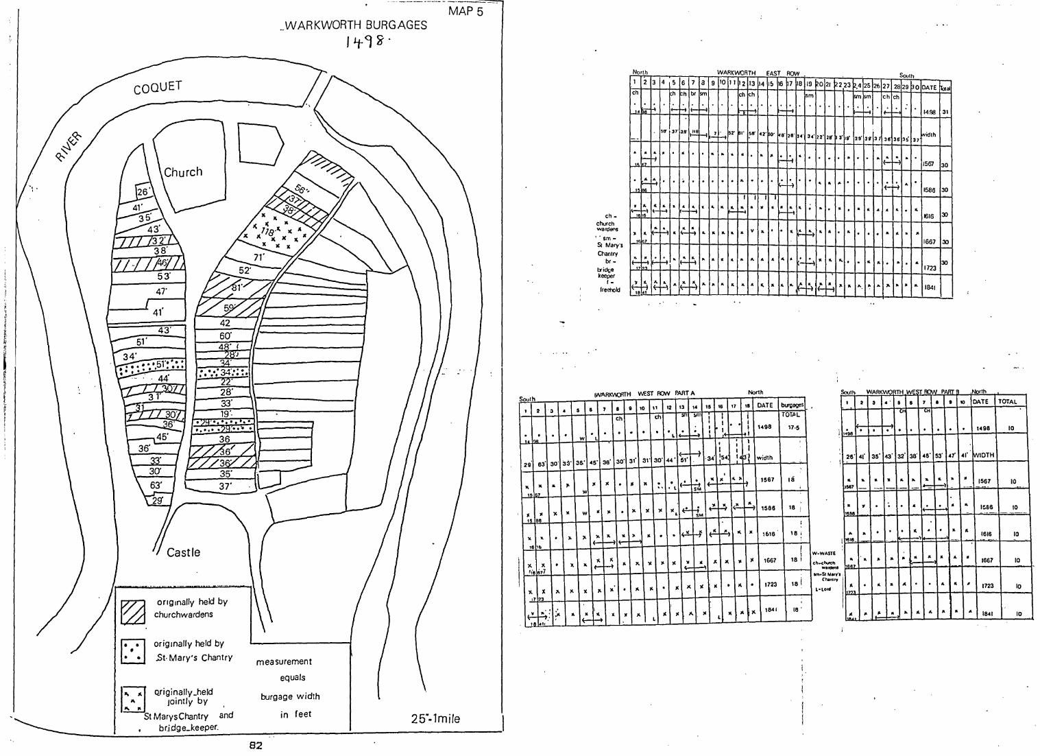
COQUET
~ r::-:l ~
28' 33' 19', .. .... ..
orrglnally held by churchwardens
' .. ~ . .
origrnally held by
.st, Mary's Chantry
" Jointly by ... ,.
"WARKWORTH BURGAGES
fLt<J~'
measurement
equals
MAP 5
1:21'" Qriginally_held burgage width
St Marys Chantry and in feet 25".1mi/e ~ _________ !-__ ~ __ :b~ri:d9~e=_~k~ee~p~e~[~ ______ ~------------~----------------______ __
82
Soulh
I 2 '3 •
0 . . . I""
29 63' 30' 33'
" " .. l'
15 1• 7
- " )\ " 15 B6
" " • 7-
,616
)I. X • X ,,'6677
lI. )( ,.. X
,723
~,: ;,. ~ .. , 18 ."
ch _
church wardens
l' sm-Sr Mary's
Chantry
br -bridge keeper
f -freehold
North
1 2 3 4 5 6
ch f;h ~h
'0 ~ ~ II-t:t 56' 3" 3.8'
,
. . ~ . · • t-
.~ ~. · • "I ..
r ~ :.-~ · " ~ f-,6
~~ ~ " • ·1 .... 1 7
I~ M ~ ~. .. 1(-
" I ••
l~ ~ l~ ~ " I~
7 a br sm
i~ ~
.~ f-i . .
. .
.. . H
~ ..
~ ..
r4"
WARKWORTH EAST ROW
9 10 11 12 13 14 1& 6 17 la
ch ch
h' H ~ .:.
~ ~ 52' ~I' 58' 42' ~' ~8' 2S' 34'
.. " .. • . .. Ifo ;-. ~ ..
. . . .. 0 . . ~ . ~
f f f t .. ..
~ .. .. w " • ~ .. -I f-
.. .. " • v " . 0 .ft.
" ~ .. .. .. " " .. . . c-
.. .. .. .. " ~ .. .. .. (...
lWARKW)'ITH Y\£ST PON PART A North
6 7 s I 10 11 12 13 14 15 16 17 16 DATE burgages 5
ch SIT 6m 1 I TOT.AL ch ! I
I I : i' !+
• 0 I 1498 17,5 0 . . . . . . I~ f...4 f-f.+i L
W L I , , I
,
~ I I I
(-·34 :54, Ij3'~ width
3&' 45' 36' 30' 31' 31' 30' 44' 5'- ..
,
~ " " .. ,. 1561 18
)I )I . If II . . If!.-.. , ~ I W
W . )r. )( " lCL l~ ri .. ? ~ :~ ~ 1586 18 I
W ,.
lI. " ,. II . ·l~ r-; l~ ~ ... ,.
1616 18 i )\ '" ,
( '" ~ I<. " )II lC " ~
1. J< " )C 1867 18 ,
" .~ II ~
. lC X lC )I • .. . 1723 181 II )I. )II . '" '"
, I
I '" ')I.
1841 18 '
l~ ~ , II >Co lC )I ... )\ II
L l
Soulh
19 021 ~223 ,425 2b 27 2829 30 DATE !Taal sm ~ 'm ch ch
r.:... H i~ --I 1498 3t
34' 22' 28' 3' 19' 29' 29' 37 36 36' 35 37 fYidlh
. . . . .. · . "I?-..
" .
H 1567 30
0 .. .. .. 0 · 0 'f- -i " 15aa 30
. .. 0 .. . · " .. • .. 0 ~
1616 3:)
~ .. .. . .. · . 0 .. " .. " 1667 30
~ .. .. .... o .. .. 0 .. . .. 30 1723
f4 It. ~ .. .. '" ~ '" .. .. • .. 1841
South WARKWO TH WE~ TOO 'N_ PART I
1 2 ,
i 0 . 498
, 26' 41'
: . .. .. 567
.. ., 1"66
... .. I te,s. -
w-wASTE
ch .. church wardenl
Im-SI Mary· Chlnlfy
L-Lord
I,
.. .. "RR7
lI. . :,~.
3
. 35'
.. -
.
.
-..
.' • 8 7
CH ~H
0 . . 0
43' 32' 38' 48'
'I .. .. .. . - .. I~
~ . " . . . " .
- .. ~ f-,-'
- - .. " :
.. A . .
I,~, ".I~ .. .. .. .. ~
8 •
. . 53' 47'
.. a ~) .
0 •
. " ..
a ..
.. ..
" ..
North
10 DATE TOTAL
0 1498 10
.. ,.' twlDTH
" 1561 10 -.. - ' .. . .. -
.. 1~88 10 . -' . .-
.. 1616 10 -- .. .
• 1661 10 .
# 1123 10
'" 1841 10

SECTIQN 3
The Analysis of the Borough Plans
Part 1 Influences on Borough Form
Site is considered a major influence(l) but the motive of
the founder is a significant influence on settlement ,form.
However in the unstable conditions of Medieval
Northumberland each borough .form was influenced by the
environment in which it originated. Being situated in the
unstable borders between England and Scotland must have
affected the choice of site and the subsequent growth of
boroughs such as Warkworth and Morpeth, both of which were
laid out in river meanders(2). River crossing sites such as
Haydon Bridge, Felton and Corbridge are all built above the
haughs. Newbiggin straggles along a level part of the coast,
whereas Alnmouth is restricted to a narrow sandstone ridge
at the mouth of the river Aln(3). However, as trade was an
important consideration in borough foundations accessible
sites were sought. Changing functions may also be reflected
in the plan detail. Alnwick expanded away from the defended
single street borough near to the castle(4) , presumably due
to its increasing importance as a trade-centre.
The plan detail could also have been affected by relief.
Alnmouth block two is restricted in length because the land
falls away to the sea(5) while burg ages in Watling St
(Corbridge) and Felton West Row(6) are short for a similar
reason (except that the fall away is to the river). Hexham
did not expand to the north of Haugh Lane because of a sharp
drop in height north of Market St(7).
Pre-urban nuclei have affected some of the borough plans.
According to Conzen Alnwick has grown up- around the junction
of three Anglian routeways(S) resulting in a distinctive
triangular central area, while the site of a pre-Conquest
83

church has been incorporated into the plan of Warkworth, by
rebuilding the church on the same site(9). Indeed, if each
borough plan is considered in its broadest form, then the
factors outlined above, site, situation and pre-urban nuclei
would prevent any generalisations being made. It is however
at a more basic level, that of the individual components
which make up the total form, the market place, church,
castle, street system and especially the fundamental
distinguishing unit of the borough - the burgage plot - that
this analysis concentrates.
(A) The Town Plan
Before beginning to analyse the borough plan it is
imperative to have a clear understanding of what is meant in
this research project by the term town plan. A restricted
definition of a town plan has been used in the analysis.
Town Plans contain three distinct complexes of plan element=
1. Streets and their arrangement into street system;
2. Plots and their aggregation into blocks;
3. Buildings or more precisely their block plans;
(with streets referring to the area between street lines,
the areas bounded by the streets being blocks and each
block representing a group of contiguous land parcels i.e.
plots and the block plan of a building defined on the ground
by the line of its containing walls) (10).
In this analysis section 3 will be excluded because few
individual, and no contiguous blocks survive in the
Northumberland boroughs. The block plans like the buildings
they represent are the least conservative element in the
town plan(ll) but rebuilding is thought to have taken place
within the existing property boundaries. Therefore street
systems and plots will be analysed together with the more
84

obvious.~edieval remnants in the present plans vizl the
church. castle and market placea in order to discover
whether there are any common features between the
Northumberland boroughs, thence to attempt to explain any
similarities.
85

TABLE 7 Borough Plan Element~
I .. -... _____ •• _4 ~ ____ ~ -- ..
TOWN CHURCH CASTLE ! STREET SYSTEM MARKET PLACE i
- .. - _ .. .. _--I South of 1 single st reet
,A!-NMOUTIJ; Borough None 2 rows of None ! \
I pre Conquest burgage5
Outside North of Radial Irlangular Converging of
AlNWICK Borough Concentri C
3 Anglo ,
Saxon the Boroug h back lanes roadwavs -In the Nort he rn Converging Rectangu la r. Wide on
CORBRIOOE part 0 f the None Main Street Market place Market place
for droving
To the West .1_s i n9J.e_ sJ r.eet_
FELTON None 2. rows _. of. bu rgages None of the Borough
back. access _ .. , ----
HALf - South. side_oLthe __ _ R.emains. _____ .Sj ngl.e_5treet_ .T.rJ.a nguJ a r ____
ma.i n. street _and._. .S.o u. ttL-oJ , 2_rows _oL _a nd_ -I a.t e ,r __
.WHISTLE . seconda r.y_.ma rket_ .. Maj rt--StreeC Q. u tg.a ge.~ __ _s.m aLl~r_ squar.e_ ..
_N_o r.th_of __ ..
HARBOfTLE None Ma in_S.tr.e ej_ . As 'Above None
HAYDON Nort h_oL the_rjyer_ .D.ou b I eo. s i n9 I e. __ _V'{i.d e._ st reet _ Eas.Lslde-Of_t.be_ None. s t r e e t s _ with. .._- -
BRIDGE .bUJg~.g.e_se.r ies_ back_.access __
_ in _No~th __ .. - . - -~ .... ~ ~ ... .. •••• "4 -- --- .. _._--- .. -- .... - .. ... ~.- -- -.. ~ - -. _. .-
Wes 1. .of. th e .. ~ _C 0 mpos it e ___ HEXHAM None Squa re
MackeJ_p.l.a.c,e_ . ..
HQL.Y_ S.o.ulh _Qf_t.h e __ Outside ___ -<:'0 n vergi ng_o n .. ISLAND Ma I.k e. t_pJa.C.JL_
the. __ .town_ M arke.t_P.I ac e_ . -. - ---- ..•. -.-- . .. .- . - -
SO.lith_oJ South .. , -..8f .. _In.ve.r.t.e d ___
.MORPETH " II
J.be_boJo ug.h. __ th~boIough .1 etter_ •. _ T __ .... _._
We ste.cn _S.ingte_. str eet.._ NEWBIGGII\ t',io ne .. -- 2:_rows_.of __ . NO'l1e
..E..r.OJIl O.n t oLy. _.bu(ga e s_. __ .. ___ .. - .. - - . .~ .. - -~--- - .. .. ---- - - ~ ...
_No r.t.b __ West_ .. ~a. s t. __ of __ .-------.~O.RHA~f.
.• As. -. Above T ria ng u I a'r _QJ __ B.oJ,ough_ I t h e._ bo rough
.. -. M ___ '"' ..... w _, ,_. __ • .-__
- - .... - .-- '-'. --- .... .- ..
ROTH - .South_.side_of_ Wide No ne_ ,
BURY Ma.r.k.eJ_ar.e.a_ II Main S reet
.W~RK -, .Nor.t.h_o.f __ S.ouJ.h_o.L .. . Bor o ugh_j.ll_t.he.
t he_bar . .'ough : II . Triangu lar WORTH .M arke.t_EI ace_ -
_.1 "-centre_o.f_ _M o_tt.e_n ear_ Co nce n t ric -WOOLE~ ! Amo rphous
MaJ.ket.--PIJ!c_e_ _C_hu'rch • R ad i a I
---_.------.- -- .... ~. .--- .... -~-.----
86

CB)Elements to be Comparedlt has been suggested that the
location of the church, castle and market place shape may be
common elements(12) at different periods or within planned
towns or towns in the control of certain landlords, but this
has not proved a fruitful avenue of research.
1.Church
Looking at the siting of the churches (see table 7) within
the boroughs, 3 are in the market place (Warkworth,
Corbridge and Rothbury). Although Corbridge and Rothbury are
pre-Conquest, the evidence suggests that Warkworth was
replanned in the C12th(13). However as the first reference
to borough status in Corbridge and Rothbury as well as
Warkworth is in 1201 it is possible that they too were
replanned in part in the C12th(14). Although all of these
boroughs eventually belonged to the Percies, Corbridge
originated as a Royal borough. Four of the boroughs have
churches which form one side of the market place
(Haltwhistle, Hexham, Holy Island and Wooler) (15) but they
were laid out at different times. Although Hexham and Holy
Island have ecclesiastical seigneurs the other two,
Haltwhistle and Wooler, were lay foundations(16). Four
churches are sited, away from the present street system
(Alnmouth, Newbiggin, Felton,and Morpeth) (17) and all are in
planned towns but other planned towns have churches with
Moreover, Alnmouth and Felton have different locations.
shrunk but Morpeth's church is the remnant of an earlier
settlement. Norham, Bamburgh and Alnwick have churches
within the street system as do Newburn, Haydon Bridge and
Mitford but there is no link between them. in terms of
landownership pattern,foundation date or degree of
planning(18). Therefore, there appears to be no common
87

MAP6
,
CASTLES BUILT IN NORTHUMBERLAND IN THE
MIDDLE AGES
(Qft~r "HUNTER -BLAIR 1944)
!,\
.WOOLER .MIDDLETON
• HARBOTTLE
~ .ELSDON BELLINGHAM WARK ' • GUNNERTON
" ·SIMONBURN
88
• ROTHBURY
,BorHA ," ·MORPE~
-MITFORD ,.BOLAM
48kms

TABLE 8
Castles Built in Northumberland
after Hunter-Blair
Earldom
Liberty
Barony
*Bamburgh 1070
*Newcastlel080
Tynemouthl081
*Warkworthl139
Elsdon 1080
*Harbottlel157
*Norham 1121
Wark(Tyne)
*Alnwick 1100
Bolam 1100
Bothal 1150
*Mitford 1100
. *Morpeth 1090
Prudhoe 1100
*Wark(Tweed)
*Wooler 1100
Uncertain Origin
Bellingham
Gunnerton
*Haltwhistle
*Rothbury
Simonburn
* Denotes borough status.
1139
1100
89

location between any group of churches within the boroughs
of the county.
2.Castle
Eleven boroughs have castles but they date from before and
after the Conquest, and although 50Y. of the planned towns
have castles it is by no means correct to assume that all
planned towns are associated with castles, as is the case in
BOY. of the Welsh foundations(19). Moreover, if the castles
in the county are mapped it is apparent that they were not
all accompanied by planned settlements(20). There is no
evidence of borough status at Middleton, Bothal, Bolam,
Elsdon, Gunnerton, Simonburn, Wark(on Tyne) and Prudhoe.
3.Market Plac~
Market places come in all shapes and sizes(21) , although a
rectangular form is common in England. Within the
Northumberland boroughs it is possible to identify four
major types of market place as shown in Table 7. Single
street markets are characteristic of Alnmouth, Felton,
Harbottle and Newburn whereas triangular markets in Alnwick,
Bamburgh, Haltwhistle, Norham and Warkworth. Although it was
postulated as an Anglo Saxon form by Thorpe, these markets
date from periods as diverse as early post Conquest Alnwick
and the C19th when Bamburgh was replanned. Rectangular
markets are found in Corbridge, Holy Island and Hexham.
Although Hexham and Corbridge had flourishing cattle markets
in the Middle Ages which would necessitate large marketsJ
the same can not be said of Holy Island. In Wooler, the
smaller more amorphous form of market is found, while no
recognisable market places survive in Newton, Newbrough,
Wark, or Mitford.The often used phrase 'market based town'
was merely a way of uniting a mottley collection of towns
90

with nothing more in common than having their market at
their centres(22). As can be seen from map 1 the granting of
a market did not correspond to burghal status in
Northumberland.
Many market places have experienced colonisation due to the
pressure on open spacel
a. Stall holders left their stalls out overnight and
eventually built on the site.
b. People with frontages on the market place tried to gain'
space by pushing their shop front forward.
c. The market place was often used for structures of public
benefit such as a market cross or church.
Market colonisation has taken place in Alnwick, Hexham,
Corbridge Haltwhistle and Warkworth. The site of the
church at Warkworth however may be a pre-urban nucleus(23).
Having considered all possible permutations with regard to
church location, castle location, street system, market
place shape together with date of foundation, land
ownership, planned or non planned town, location within the
county it is clear that this element of the town plans show
no recurring patterns(24).
4.Street systems and Burgage Plots
The most common street system appears to be the single
street, double burgage series found in Alnmouth, Felton,
Haltwhistle, Harbottle, Haydon Bridge, Newbiggin, Norham,
Rothbury and Warkworth but the reason for this appears to be
locationall being situated in a hostile and unstable border
region cannot have been conducive to the development of
trade and subsequent growth of the borough (25)
Alnwick, Corbridge, Hexham, Morpeth and Wooler all have
street systems focussed on centrally placed market places.
With the exception of Morpeth and possibly Corbridge they
91

appear to have grown over a period of centuries. Hexham,
Corbridge and Wooler all have one wide main street as would
be expected in cattle rearing areas(to facilitate cattle
marketing). The converging street system of all five is also
a reflection of the nodal marketing function for their
respective hinterlands. It would appear then, that no common
street system is evident in the Northumberland boroughs.
However, the composite nature of some plans may hide common
patterns which are obscured, eg.Hexham appears to have grown
throughout the Middle Ages(26). The original single street
borough of Market Street and Gilesgate is obscured by later
accretions including the market place, Fore Street and the
Priestpopple area, Priestpopple, Battle Hill and Hencotes
appear to be three distinct plan units although today they
are one continuous street. Thus what appears today as a
converging system was originally a single street borough.
Alnwick too ,may have originated as a single street defended
borough between the castle and the church (27) in the
Bailiffgate area with the extension of the settlement later
in Sondgate, Fenkle Street and Clayport Street which gives
the plan a converging street system.
The burgage plots, however, seem to offer a more rewarding
line of inquiry. The critical and distingiushing feature of
the borough was the form of land tenure and burgage tenure
was placed first in the privileges granted by charter(28).
Indeed, the burgage tenure is the only characteristic which
all boroughs had in common and as the tenure was represented
on the ground in the form of a burgage plot, then perhaps it
is here that the group of settlement boroughs, can be
distinguished as a spatial form.
Perhaps it is at this level of planning that the planned and
organic towns can be distinguished from each other. Was a
92

burgage a measurement unit? Rarely was burgage size
recorded. Was this the exception, and unless otherwise
stated was a common size(whether by area or by width)
assumed?
It is of some value to consider whether planned and organic
towns have different burgage sizes, with organic having no
one common size, or whether it was likely that Royal and
seigneurial boroughs may have had distinctive patterns, with
the probability that Royal boroughs were planned in
multiples of the statute perch and the seigneurial boroughs
laid out using the local standard perch of 18'. Again it
might be useful to consider whether burgage sizes change
depending on the date of foundation or whether there is a
burgage plot size common to Northumberland, which is
different from the statutary size for the country as a
whole. It is also probable that the land ownership system
whether royal or ecclesiastical might have affected the size
of the burgage plot.
Width of plot rather than the area or length appears to be
the most common method of planning burgages but comparison
of Medieval and modern measurement units is difficult.
(C) Comparing Medieval and Modern Measurements
A major problem in trying to establish whether or not there
was regularity in the burgage plot widths in Northumberland
stems from the problem of establishing what was the size of
the Medieval perch in Northumberland at the time when the
plots were laid out.
The statute perch was not used consistently throughout
England in the Middle Ages. Norden discussed the existence
of 16.5',18',20',and 24'poles(29) and despite many attempts
at standardisation from 787 A.D. onwards the most
comprehensive being in 1196 and 1305 (statute of
93

~QYE_~~lmmis~Lqo. on Weights and Measure~
Perch Sizes in th~ U.K.
County/C~untry Perch length Purpose
16.5'
Syds Fencing
7yds Forest
25' Sherwood
6yds Coppice
Devon 16' Stonewodc
Ber~(s lS' Roughwork
Hereford 7yds Fencing
Lancs 5.5-Syds
Herts 20'
Leics Syds Hedging
Oxford 6yds Draining
Westmorland 7yds
Guernsey 7yds
Jersey 22'
Scotland lS'
Ireland 7yds
94
TABLE 9

TABLE'10 -
Northumberland Medieval Church Measurements
INTERNAL INTERNAL " , ,
NAVE WIDTH NAVE LENGTH - -- - ." ..
C7th feet feet ,.
BYWELL ' , .. 19 54
.. -, , ' ~
.. CORBRIDGE 18 47 ._._ v. __ ._ • __ ,. __
•• 0.
J,
JARROW 19 90 .. . ,
.' : "
HOLY ISLAND 53 90 r " --' .. -
pre 1066
INGRAM 11, 30 -.-_. ---_." ... '-' _ ... _-.. _-.. -_.-.- -_ ... .. -- - .--~-- . --.
Saxon
HEDDON Norman 17 51 - - . . - -. ',"""
• _.. 'O-M._",.· '~" •••• ......... -.
. '
WOODHORN 18 45 . . .... . - . , - ~ .. - -- - ..... , .... ._-_._. _ .......
- "
OVINGHAM 20 51 -- .. - .. - .-.- ... --- .... -.- "'~-' .... -- _. .. .. -
WHITTINGHAM 18 53 . . - - ., .... - .
HOUGHTON 18 33 - . . -.. ---_. __ ." •• A •• _ .'. _., .. .. --........
~
MITFORD 20 57 .. .- . --... --
;
WAR KWORTH 19 90 - ....
,
, , ~
21 I .8AMBURGH I 58
SQURCL,ANGLO SAXON.,ARCHITECTURE_1965 _______ .. _
95

Northumberland Aisled and Tower House Measurements
H.M. Taylor Anglo Saxon
Architecture 1965 and Fieldwork
Aisled House Inches 16.5' 18' Inches 16.5' 18'
Bishop Aucklandl020
Warkworth
Aydon
Tower House
Corbridge
Chipchase
Bamburgh
Holy· Island
Norham
684
570
204
624
396
552
1008
5.15 4.75 540 2.72 2.5
3.45 3.16 492 2.48 2.25
2.87 2.6 216 1.09 1
1 1 264 1.33 1.22
3 2.8 240 1.2 .1. 1
2 1.8
2.75 2.5 204 1 1
5.09 4.66 720 3.6 3.3
96
TABLE 11

admeasurement) (30), local custom continued to prevail until
the early C19th(31) because the opportunity to use the
local customary perch r'emai ned,' and no cl earl y i ntell i gabl e
system was applied nationally. The term rod, perch or pole
in many cases simply meant just that, with precise values
being attributed to the pole when it was used as ~ m~asuring
instrument. Evidence can be found for the wide variety of
perch' lengths in use throughout England in the 1820 Report
of the Commissioners on Weights and Measures which recorded
values ranging from'16 to 24 feet still used at the
beginning of th C19th(32) ,the size depending on the nature
of the measurements to be taken and usually different for
urban, arable and forest I and (33) • In some pI aces
differences were recorded within the same type of
settlement(34). As Grierson concluded
'It(the perch) is one of the most imprec[se and elusi~e of all medieval measurements' (35)
But he added that
'while variations over space were common there was stability over time in the length of the local perch. The structure of society, neither called for or allowed wide communication of length standards' (36).
Although no medieval measuring rods have survived Jones(37)
has argued that the local perch was derived from the church
perch which was often sculptured on the side of the church,
e.g. Harleston but none survive in Northumberland. Some
Medieval buildings do survive in the county however, and it
is possible that the local perch can be established from
church or aisled house dimensions. After consultation with
Taylor's Anglo-SaMon Architecture(38) it was apparent that
the heights of the towers at Bywell, Corbridge and Bolam,
the width of the Nave at Corbridge, Jarrow, Woodhorn,
Ovingham, Houghton and Mitford, the length of the Nave at
Jarrow, Holy Island, Woodhorn, Ovingham and Warkworth, the
97

height of the nave at Houghton and the width of the Chancel
at Ingram all fit into exact multiples of 18'. Other church
measurements however such as the nave at Hexham and all the
measurements at Warden fit more closely to multiples of 16
1/2.
The dates of the buildings span the whole of the ~edieval
period(39) and it appears unlikely that the perch size
changed over time, as Bamburgh and Houghton are both post
Conquest and have different multiples while Hexham and
Bywell are pre Conquest and have different multiples.
Nash (40)
'favoured local variation upheld by rigid tradition change from neighbouring measures, time, and Parliament'
against acts of
Either the measurement errors obscure the consistent use of
one measurement or different lengths were used in the
county. However when the ratio of length to width of
naves(internal measurement) is considered, the evidence
suggests an 18' multiple may have been used. The following
ratios of width to length are taken from table (each
measurement was divided by the local perch of 18'):
Bywell 1:3; Corbridge 1:2.5; Holy Island 3:5; Ingram 1:3;
Heddon 1:3; Woodhorn 1:2.5. Ovingham 1:2.5; Whittingham 1:3;
Houghton 1:2; Mitford 1:3; Warkworth 1:3.5; Bamburgh 112.5.
This evidence suggests that an 18' perch might have been
used in church/ecclesiastical measuring. Even if 18' is
accepted as the perch length used in Northumberland in the
Medieval period in ecclesiastical building it is not wise to
use ecclesiastical building measurements for other purposes,
without checking their validity. After all arable and
woodland perches are very different(41).
Aisled and tower house measurements maybe a more suitable
source of information(42). Table 11 shows that of the eight
98

aisled and tower houses surviving in Northumberland (Bishop
Auckland has been included as it was built by the bishops of
Durham), it is not clear that one multiple was used. Bishop
Auckland Aydon and Warkworth fit loosely to an 18" multiple
while Bamburgh, Holy Island, Norham and Chipchase are
unclear but fit more closely to a 16.5" multiple. It would
appear then two different perch lengths were in common use
for building in Northumberland throughout the Medieval
period, namely 16.5" and 18"
Documentary evidence may be more useful in trying to
establish the local standard. The Black Book of Hexham
Priory(43) mentions "Idem Ricardus simililer retenuit
latidudinem duarum perticartarum per
similar references can be found
chartulries(44). This would appear to
perticam xx pedum"
in the other local
confirm ·Sheppard"s
conclusions from Wheldrake(45) but these references are all
ecclesiastical and may be purely ecclesiastical in use
(aisled house measurements do not fit into the same
groupings as the chancel and nave measurements). It may be
possible that xx pedum was stated because that was unusual,
alien to local custom, as many refernces to perches are
mentioned without a specified feet multiple(46).
When attention is focussed on urban perches in the
documentary evidence the most common multiple appears to be
18"(47). The laws of the four burghs indicates that the
perch size used in Glasgow was 6 ells which is approximayely
18"(48) and as the laws were based on the Anglo Saxon Laws
which prevailed in Northumberland, this may be an important
clue in the search for the Northumbrian borough perch. It
would however be impossible to choose one perch from the two
possibilities. Conzen(49) did attempt to find 33" multiples
in Alnwick in line with the statute perch. However his
99

results may be suspect because I the measurements were taken
from a map of 1774 and the accuracy of the document has been
questioned(50); 28-33' were taken as belonging to one
category which is a possible error of 25% •
Some doubts have been raised by Roberts and Taylor(51)
about the accuracy of Medieval surveying,
'What can be said about the actual methods of Medieval land measuring must largely be conjectural but there is little doubt that the resultes achieved were very approximate'
Roberts argued that a rod of 16.5' was less likely to have
been used than a 1/2 or 1/4 rod and even if great care was
taken, an error would be expected to accumulate as a result
of repeated measurement on sloping or uneven ground(52).
Such doubts have been rejected by Darby(53) and Nash (54)
while Crummy's work on Winchester and Sa1isbury(55) and
Slater in the Midlands(56) show that planning showed a high
degree of accuracy in some cases. The Court Rolls of the
C15th and 1ater(57) also attest to the zeal with which the
'measurers carried out their task. Therefore an error of
25% is perhaps overgenerous and may result in forced
groupings of statute perch multiples being found in A1nwic~c
and Stratford(58).
It would appear then that 16.5' and 18' are the most likely
perch multiples used in Northumberland but how can the plots
be measured accurately in order to distinguish which perch
was used in town planning?
100

(D) Measuring Accuracx
There are four alternative ways in which the plots can be
measuredl
1.Direct measurement from O.S. 25 11 1st edition plans
b Direct measurements from earlier maps checked against
the 1st edition 25" O.S. plans
c Digitising
2 Air Photo measurement
3 Chai n Boo~(s
4 Field Measurement
A method using the C19th and earlier maps was pioneered by ..
Hannerberg and Goransson(59) in Sweden and has been widely \
used in England by Sheppard and Roberts(60) working on
villages in the North of England. Essentially it involves
measuring whole street lengths of tofts with a premarked
ruler (marked with different multiples) (61) to try to
establish a regular toft multiple, assuming that the error
would be cancelled out over a whole row. A modified version
of this technique was used by Conzen(62) in his analysis of
the plan of Alnwick and his major problem was that
'When applying these considerations to the evidence of 1774, the main difficulty is to obtain accurate measurements within 1 foot on the MS original of Wilkins map. Therefore a margin of error of 1 foot has been allowed wherever measurements deviate from either units or multiples of those dimensions which are most frequently found' (63)
Both of these methods however, suffer from a problem of
accuracy because they use maps. Bearing in mind that lmm = 8' on the 25" O.S.plans, a line on the map which is 0.5mm
wide is actually 4 feet on the ground, thus introducing a
possible error of up to 8 feet on every plot measurement
101
which is 25% of the statute double perch and this is a level
of inaccuracy which is unacceptable, if the degree of
planning is to be established. Even if the plans were
digitised the level of accuracy required would be impossible
to achieve(64). An alternative source of accurate
measurements would have been the 0.5. Chain Books of the
original Survey but these were destroyed during the Second
Wor I d War (65) •
This leaves field measurements of the plots which have
survived (traced back to the Middle Ages using documents).
Thus a higher degree of accuracy can be achieved. Although
some plots have not survived, there remains a large enough
sample from which to make worthwhile conclusions. The
measurements have been taken in feet because it is not
certain which perch multiple was used in Northumberland
during the Middle Ages(66).
Problems arise in deciding where to take the measurements
from - to the outside, inside or middle of boundaries. To be
consistent the midpoint was chosen bearing in mind that the
1983 building line might obscure some boundaries. Comparing
the field measurments with those taken from the 1774 map of
Alnwick by Conzen indicates that' either redevelopment has
obscured the C18th burgage series or that field measurements
are more accurate.
102

REF ERE N C E S
1. Op cit Aston and Bond p84.
2. O.S. map NU2405-2505 1960 Warkworth.
O.S. map NZ1885-1985 1971 Morpeth.
3. O.S. map NY8264-9364 1954 Haydon Bridge.
O.S. map NU2410-2510 1959 Felton.
O.S. map NY9864-9964 1962 Corbridge.
O.S. map NZ3088-3188 1965 Newbiggin.
O.S. map NU1800-1900 1965 Alnmouth.
4. Op cit Aston and Bond p85.
See pp138-9
5. See the reconstructed plan of Alnmouth p130-33.
6. See the plan of Felton p145.
7. See the plan of Hexham plSl.
8. Op cit Conzen p13.
9. Symeon - Hist Dunelm Ecclesiae lib.ii cap.l rolls
series vol.i p47.
'intravit autem (Ceolwulfus) Lindisfarnense
monesterum, sancto Cuthberto secum conferens thesauros
regios et terras, id est Bregsne et Werceworde, arm suis
appendiciis simul et ecclesiam quam ibidem ipse
aedificaverat; atias quoque quattuor villa wudcestre
Hwittingaham, Eadulfingham, Ecgwulingham'.
10. Op cit Conzen p4-S.
11. Ibid p7.
12. Op cit Hindle p17.
13. Private Discussion with B.K. Roberts.
14. See Appendix 6.
15. See Table 7.
16. See Table 7.
103

17. See Table 7.
18. See Table 7.
19. Op cit Beresford p18l.
20. See map 6
Op cit Blair 1944.
2l. Op cit Aston and Bond p96.
22. Op cit Hindle p14.
23. See reference 9 pl03.
24. See Table 7.
25. Op cit Aston and Bond p97.
26. Op cit Wilson.
27. Op cit Pevsner p65.
28. See Section 1 Part 2CA).
29. Norden J. - The Surveyors Dialogue1610 p180.
30. Jones A. - Land Measurements in England 1150-1350 in
Agricultural History Review 1979 vol.27 pl0.
Statutes of the Realm vol.l Statutes of
Admeasurement p206-7.
'The iron yard of the king the lord containeth three feet
and no more, and a foot ought to be 12' by the right
measure of the yard measured to wit the 36th part of a
yard rightly measureth 1" niether more or less and
five yards and one half maketh one perch that is 16'and
a half measured by the aforesaid iron yard of our
lord the king'.
31. Taylor E.G.R. - The Surveyor in The Economic History
Review vol.xvii 1947 p128.
Op cit Jones p13.
Newman L.F. - Weights and Measures in Folklorelxv
3 1954 p135.
Hunter-Dupree A. - English Systems for Measuring Fields
in Amateur Historianxlv 2 1971 p122.
104

Nash A. - Perch and Acre sizes in Medieval Sussex in
§.H~!?.~)( Archaeological CoIIJ~!=_llin116 1978 pp57-62.
Maitland F.W. - Domesday Book and Beyond 1898 p375.
Salzman E. - English Trade in the Middle Ages 1931
'As so often in the Middle Ages local custom was
stronger than national law'.
32. Following the report of the Commissioners for
Weights and Measures British Pari. Papers 1820 p473.
33. Op cit Hunter-Dupree pp12-14.
34. Rothbury North Row compared to the rest of the
settlement and Holy Island.
35. Grierson P. - English Linear Measurements The
Stenton Lecture p20.
36. Ibid
37. Op cit Jones p10.
A similar origin has been proposed for Little John's
Grave in Addy S.D. - Little John's Grave and the Lawful
Village perch in Derby Archaeology and Natural History
Society vol.xlvii1925 p206-21.
38. See Table 10
Taylor H.M. and H.J. Anglo Saxon Architecture 1965
39. Ibi d.
40. Op cit Nash p58.
41. Op cit British Pari. Papers 1820.
See Table 9.
42. See Table 11
43. Surtees Society 1864 p120.
44. Newminster Chartulery in Surtees Society 1878.
See Appendix 16.
45. Sheppard J. - Pre-Enclosure ,Fields and Settlement
Patterns in an English Townshipi Wheldrake in Geog.
Annaler 1966 vol.48 p59.
105

46. Op cit Surtees Socie~y 1878.47. A.P.S. i p751 'De rude
off lande in baronyis sal conten siH elne pat is to say
\viii fut off a mydling mane.'
See AppendiH 16.
48. Dickinson W.C. - The Early Records of the Burgh of
Aberdeen 1398-1407 in' Scottish History Soci~ 1957
pHlv.
49. Op cit Conzen p33.
50. Wilson M.L. - Measuring Burgage Plots in Are.,A 1979.
51. Roberts B.K. - Village Plans in Durham in Medieval
Archaeology vol.16 1972 p33
Op cit Taylor.
52. Op cit Roberts p43.
53. Darby H.C. - The Agrarian Contribution to
Surveying in England in GeograRhical Journal 1933 p530.
54. Op cit Nash pp57-62 •.
55. Crummy P. - The System of Measurement used in Town
Planning in SusseH Archaeglogical Collection
56. Op cit Slater.
57. See AppendiH 11,12,13.
58. See Appendix 7
59. Hannerberg D. - Turneroch a~(ran n~gra gl i mar I,Jn
kultunlandskaRets historia 1955 p148.
Goransscn S. - Morphogenetic Aspects of the Agrarian
Landscape of Oland in Oikos SURRlementum 12 1969
pp67-78.
'Through the metrological method, new approaches are
opened to the comprehension of how and when the various
components of the rural landscape were created'.
60. Sheppard J. - Medieval Village Planning in Northern
England= Some Evidence from Yorkshire in The Journal
of Historical GeograRhy vol.2 i 1976 pp3-20.
106

- Metrological Analysis of Regular Village
Plans in Yorkshire in The AgricLiltural
History Review vol.2 1974 ppl18-35.
Roberts B.K. - Village Plans in County Durham in
~edieva1 Archaeology vol.16 1972 p43.
- The study of Village Plans in Local
Historian ix 15 1971 pp233-41.
61. Private correspondance with D.H. Maling
See also Kishimoto H. - Cartometric Measurements 1968.
62. Dp cit Conzen p32.
63. ,UJid
64. Private correspondance D.H. Ma1ing.
65. No evidence of survival in the P.R.D. British Museum
or 0.5. Southampton.
66. See discussion of church, ais1ed house and documentary
references to perch sizes discussed in this section.
107

SECTION 3
E~rt 2 - Analysis of Burgage Plots
In the past burgage widths were usually considered at the
scale of the individual borough(1). The widths were plotted
on to graphs and analysis based on the search for recurring
multiples(2). When these graphs are constructed for
Northumberland boroughs it is apparent that no unit
dominates in any of the Northumberland boroughs, although
36'(two 18'perches) is the most common size in Alnwick,
Haydon Bridge, Rothbury, Warkworth and Wooler, while 33' is
the most common size in Morpeth(3) (See appendix 17).
However can the assumption of continuity of plot boundary be
made? It may be more revealing to consider individual blocks
of burg ages within boroughs because it is not at all certain
that continuity of plot boundary can be assumed or that any
of the boroughs was planned as a single unit, using the same
multiple, or even whether one multiple was used within a
block.
The reconstructed plans of Warkworth, Alnmouth, Rothbury and
Alnwick will be considered first. Each borough will be
discussed using the reconstruction table, field measurements
of burgage widths and any early Medieval references to the
burgage series
WARKWORTH
When the reconstruction of Warkworth burgage series for 1498
was completed burgage No. 30 corresponded to plot 29a on the
Tithe Award (the last burgage in East Row before the
108

Castle). It would appear that plots 31 and 32 are part of
plot 30, lying behind it and having a side frontage. Plots
33 34 and 35 in the table seem to be plot 71a on the Tithe
Award. Therefore, because plots 31 to 35 do not form part of
the main burgage series of East Row they will not be
included in the analysis and no further speculation
regarding their location will be made.
Analysis of the Burgage Series
Warkworth East Row(See table 12)
As the table shows, there is a clear correspondence between
the burgage plots in 1498 and 1983. There are only a few
anomalies which must be pointed out. Firstly there is no
record after 1498 of a plot between plots 12 and 13. This is
the site of the Kilnhouse and the burgage referred to may
have been located behind the Kilnhouse. Subsequently the
plots were referred to as one. Secondly, the 1498 rental
records two rents of 4 shillings which cannot be traced. As
these are particularly high rents they may refer to land
held outside the burgage series. If the anomalous plots are
excluded there are 31 plots in 1498 but from 1567 onwards
the number is constant at 30 plots. The only changes after
1567 are amalgamations and divisions (which are clear from
the table) and the recording of plots 12 to 15 as freehold
in 1616. Although Mayson's survey of 1616 includes plot
sizes they do not correspond to the 1841 measurements. This
is not surprising as the 1616 survey states at the
beginning that the sizes are estimated.
In order to assess whether or not a common burgage size
exists in Warkworth Map 7 showing all the measurements has
been included but it may prove more worthwhile to
concentrate on certain groups of burgages.
109

Firstly, let us consider the plots held by the institutionsl
(Church Wardens. the chaplains of St. Mary's Chantry and the
Bridge Keeper). The following plots were held by the Church
Wardens.
Plot 5 and 6
Plot 12 and 13
Plot 27 and 28
75'
139'
72'
(Approx. 4x18' perch)
(Approx. 8x18' perch)
(Approx. 4x18' perch)
It is possible that plot 5/6 and plot 27/8 represent one
burgage of four perches subsequently divided into two plots
of two perches (36'). Plot 12 on the Tithe Award looks like
two burg ages therefore plot 12/13 could represent two 4x18'
burg ages (subsequently divided into three plots (one of
4x18' and two of 2x18'). Therefore, it is possible that a
burgage width of 4x18' was used in Warkworth for some
burgages at least.
Secondly, let us consider the burgages held by the chaplains
of St. Mary's Chantry and the Bridge Keeper.
Plot 8
Plot 19
Plot 24 and 25
118' Shared with the Bridge Keeper.
(6.5x18' perch)
34' (2x18' perch)
58' (3x18' perch)
One can only speculate on the division of plot 8. It could
represent two plots each of 3 perches belonging to the
Chantry and Bridge Keeper similar to plot 24/25. Despite
plot 19 being two perches in width, this evidence would
suggest that a burgage width of 3 perches was assigned to
St. Mary's Chantry and the Bridge Keeper (see evidence in
110

West Row). This compares with a plot width of 4 perches
assigned to the Church Wardens. This would be consistent
with a .theory which assigned constant burgage widths to
individual institutions but different widths for each
institution.
When the plots 20 to 23, lying between the Church Wardens
and St. Mary's Chantry plots,are considered they too support
the theory of a plot of 3 perches in width.
Plot 20 to 23
Plot 20 and 21
Plot 22·and 23
102'
·50'
52'
(Approx 6x18' perch)
(Approx 3x18' perch)
(Approx 3x18' perches)
Conclusions related to Warkworth East Row
From table 12 it appears that the most likely perch size
used in Warkworth East Row was 18' but a standard burgage
plot width is not easily discernable. The Church Wardens had
plots of 4 perches in width. However, St. Mary's Chantry 3
perches in width and plots 3/4 (56'), plot 11 (52'), plot 15
(58'), plot 20/21 (49') and plot 22/23 (52') indicate that a
common burgage width of three perches may have been used.
Towards the south of East Row the plot width corresponds
more closely to 36' (see plots 26-30). This suggests that
either these. plots were laid out at a different time using a
smaller common width but the same perch size (18') or they
were located in a more sought after location and therefore
the burgages may have been smaller than those to the north
in order to maintain a constant rent over different land
values, or subdivision before 1567 was more active at this
end of the row.
111

Warkworth We~t Row
The burgage series of West Row was traced back to 1498 in
the same way as East Row but the analysis can be divided
into two sections which reflect the division of West Row
into two, separated by Todd's Lane.
Section A - From the Castle northwards to Todd'~~ne(Table
13)
There are 17.5 burg ages recorded in 1498 but by 1567 this
becomes 18 because plot 13 to 14 is referred to as two
burgages and not 1.5 as in 1498. They remain unchanged until
1841 with no amalgamations and only the subdivision of 13/14
into two.
AnalYsis of the Burgage Measurements
The only plots held by institutions are 13/14 held by st.
Mary's Chantry in 1498 and plot 8 and 11 held by the church
wardens. Plots 13 and 14 measure 51' which could be 3x18'.
This fits with the evidence of a constant burgage width unit
for institutions. However, plots 8 and 11 are both 30' and
the burgage plots tend to be 'narrower on the whole than
those in East Row. Many eg.l,3,4,8,9,10,11 and 15 being
nearer to 30 or 33' which might suggest a later origin when
the statute perch of 16'6" was in common use or subdivision
was more active, or perhaps this row was originally the
selions of East Row. Conzen did find 30' was a common unit
in Alnwick.
If the measuring rod used was a yard rather than a half
perch of nine feet then it is perfectly possible that plots
in West row were laid out in smaller units (10x3') compared
to 18x3' in East Row with larger units being given to the
112
institutions, regardless of the location. This would suggest
that although plot measurements were documented in perches
they were in practice laid out using a yard measuring rod.
This cannot be verified.
Sectiqn B - Todd's Lane northwards to the Vicarag~(Table 14)
This section contains ten burg ages all of which are larger
than those in section A. Plots 1, 2, 4, 8, and 9 fit into
2x18' multiples and the only double burg age 7/8 is 78' wide
(4x 18' )
Conclusions relating to West Row
The evidence from West Row suggests that burgages near to
the castle (as in East Row) are smaller. Although there is
evidence for an 18' perch in West Row especially in the
north, it is clear that there are marked differences between
section A and section B with regard to burgage width. This
suggests a different origin from East Row or more active
subdivision before 1567.
Generally speaking the burgage plot measurements for
Warkworth suggest that the 18' perch was used in 2, 3 and 4
perch multiples but that the plan which exists today may not
have originated at one time. The southern part of the
borough and especially West Row appears to have been laid
out at a later date (if it is accepted that the statute
measurements were introduced later rather than earlier in
Northumberland). It is interesting to note that two thirds
of the plots held by institutions are in East Row. These
institutional holdings were often held from the borough's
early history and in the case of Warkworth this seems to
suggest that East Row could be older than West Row. This
113
-

would fit with a difference in plot measurement. The
existence of 3 and 4 perch burgages held by institutions is
not clear from a simple discussion of the 1983 measurements
traced back to 1567. In order to establish the possibility
of ancient burgages of 3 and 4 perches in Warkworth,
detailed analysis of ownership in the Middle Ages is
required.
114
.~ I' I ,

COQUET
34'
- _. _.... - -MAp···l- -- -- .
_WARKWORTH BURGAGES
:. • ... ·34' .. : :. - 22' , __ -----..,
28' 33' 19'·
....... - 1----..,
~ F;.l ~
originally held by
churchwardens
originally held by
.5t· Mary's Chantry
12jA Qriginally._held A Jointly by
'" " StMarysChantry . and brJdgELkeeper.
measurement
equals
burgage width
in feet
115
25"·1mile

" ot~\, .:.
--0'-
ch'church'
. wardens ':~j;. sm -
St Mary's 1
Chantry br -
bridge keeper
f-freehold
North WARKWORTH EAST ROW . -- South
1i 2.1 3" 4 5 6 7 8 9 to 11:12.13 14 15 :16 17 18 19 ~O 21 ~2:23-:'~ .. 4' 25 26 27 2829 ~O DATE Irotal t-- -' ....
ch ~h ~h br sm ch ch : , sm' J srn sm c h ch I r t
I 1 1- \ ."..:
• • : ~ I·"·',,· • _\. .. . • - . • . • . . .. " . . . .,. . . . " . I • • • • 1498 31 , 1 4 ~8 I ... ," I" k Ii. . ....
.. 7. \ j • ~ I
! , , I
, : " 'd h 56' 37' 38' 118 '52' Ioj' 8' ,~' I : i fNl t .... . " I, ,7 p 5 42 fJO' : 48' 28' 34' 34' 22' 28'!~ 3' 19' 29' 29' 37 36 36' 35' 37'
I' ( , • , ' f-- - .
, , <
! 1 ,
~ ~ ~ )( • i- • • ". )Co ". )(. • ". 1'-'. • 11. •• ."...,c. ~ )C, '" • . _~. I ,
. I ," • ", 1567 30 15167 -. , . ,
, )C.. • .• • •• ......... lI.. •
• ifll.. ~" • ;. • • • • • • il/' ~ ~ 'J(" ,. I "
. " .: ! ., . . '\ # 1586 30 \ 1586 - - . - .. - "
, . f f f fi : .. ~ '! ! r
~!'I.. J(.,c. It at)!.". J(,,)(, ~,c.". )C at:)()!. x. • )Co. It. )C.)( '" x x.. ~ I ' ... ,. . \0 " ' II. I~ I 1616 30 " ,,~. I~
1616 ' i I : , I
,c.". ~)C. , v v .:. J(. ,'I. ,c..'''' x.', ". • • • ,c. " )C. )(. .1" ... I ~ ')C. )c" )C. )C.)( "',' ,. ....
'X )(.1', • lC. " . I' 1667 30 1 ,
1667 ' ._ .. I
)C. 1)( . j • )!. '" ~ )(. )( )C. )( i)C.. " 14.:)C. at 1/. I • ~'')t )(, It... • ~ ,c. • ~ .,c. 30 , "I,'.: l\. II ~ . :1' ' ; 1723 " 17123' 1\, I I ' " • • : ±
. . I
! t
" !. )I.)()C. )C I "I.. ~ 1... '" )C.. )(. )C. .. I ~ ~ )C. x. )C" )C" J(" I)f.. ,c. ,c. :IJ!-. ~ l' >'" )Co )C. 1--., ~ )C.. ~ 1841 '\ : " .. 1.1 - '-j ; :,' I' ." . I I
" -''' , " "1 ' 18 41 -
!.I , I
-f » CD r m -.a
N
(

.... .....
"
South
1 2
• • fa 198
, 29 63'
~ X
16 67' .
)( x 15 86
'X. )(.
''16 10
~ X
Il6 677
"I... X • :7 23 _,
.. (
,')C ,..' ;
"' ':' 18 41. ,.
-
3 4
• •
'30' 33'
: , )J. ~
i
,
X 'X ,
- .
. ,
, • )c.
• ; :X
, ~ )(
: ., .~ t. ~
"
\WARK\t\ORTH WEST ROW 'PART A
, , 5 6 7, 8 9 10- 11 12 13 ,14' 15
ch , ch , SIT ~m : , \
" ~ , oj
• • .' .: J • ., • .' .: , { W L b / ~
, ; I
" ; ,
( -, 31' '30'
t ,34' 36: 45" 36' '3~' 3" 44: -51'
! I l .
)( )( X • * ~ • .' ,,- .~ ./
W 1: \
t. b '. SM '"
j
, L)( W: Xi '" X )( )( X
,. • • ... ! L '" SM
' .
i , , , ;
" I
"X ~ ,~ ~ )C. ~ ')(.
" )(. \ ,
• • ~
... , "' ~ I ,
• y I
,
')( ~ ,
x. )( x. ')( )( L --" )( 'JC )( X , . ., .... . ... •
: , , , . i , ; !
!x , X l· )( )( !~ )( • )(. ~ • X- l
: ! j
, , I , I I i , ~ , f !
)( 'It. I
)(. X )I.. " ,c i... X ./ ....
'L : 'L , . . "
North
16', 17 18 DATE I i I , I • • • 1..-
1 1498 , . I
i' I ,
I i I " I I : I ,
154': 14 3"1, width 1 I , "
I >'-; ~ ,~
.'
1567} , -, .
, ;
x~ /'X )t.\ ...
1586 I . ... , -F
,
• ; ,
)I. )(,. X' 1616, T ~
. )( 1667
, ~ )(
I ,
, . I , , • I
• )(.. • 1723 . ,
"
\ i :
, ~ !
, 1841,,- , X )(. IX
I
.- -
burgages
TOT.6L
17·5
(
.. - .
18
18
18
! , , . , 18 .
18
18
,
W-WASTE
ch-church. wardens
sm-St Mary's Chantry
L-Lord
)
"
~ l,
-f }> ro r m -> W

.... , ....
tIl
CHciurchwardens
South ____ WARKWORTH WEST_ROW PART B ____ ,North --
1 2 3 4 -, 5 6 7 8 9 10 DATE -
CH CH
/ ;> • ' . • • • • • • • • 1498
1498_ _. -. - -
! ,
26' 41' 35' 43' 32 38' 46' 53' 47' 41' WIDTH - --- --
X. lI. )(. X )(. )I. lI. X. )C. )C 1567
~567 . - -----.. - -- - -- - - :"'_------ ~ - . .- ) - - -.- -- .. - ------
. x y • • • J( • · ---"- )( ~
1586 1586. " - - --- - .-- - .-- .--- --- _ .. . ---- -- -' .". -
--• • X .. • x ~ JC. )I. • 1616
)'" ~ 1ftlEL ~ - - - I' --- - - -- - - ~... -..... ._ 0-. __ . ____
i , , ; 1
I ~ ! X. ~ X I 1<. 1C )(, -! )(. 1- 1- 1667 I )
11661' , -- -. -I I
I
I ~ • t. )(. ;(. • • )(.
I __ ~_- Jl 1723 L1723 . --~ ~-- --.. -.
,
i ]I. 1- ,,1- )(. _"J
)I. ~ Jt. J4 I )(. J4 1841 1DA1 I
I ~ .--
TOTAL -- - --
10
10 - -~-- -------
10 -
10 - -,~ ,., ---
10 -- --. ---
10 - - .. ~ . , --~ ._.
10 __ ___ _--------'_I
-f » OJ r m
---~

Therefore, in view of the evidence from the burgage series
in Warkworth, plot analysis of the boroughs where no
reconstruction is possible must be treated with extreme
caution. It may be possible to distinguish whether or not the
local perch was used in planning from the remnants of the
original burgage series but subdivision and amalgamation are
likely to have obscured the original plan.
119

ALNMOLJTH
Alnmouth occupies a ridge of level ground at the mouth of
the River Aln(4). The borough consists of one main street
which extends lengthways across the ridge from north to
south, bounded on both sides by burgage plots trending from
east to west(5). The East Row is divided into four blocks of
different length and in the analysis each block will be
considered separately with its own reconstruction table.
West Row will be considered as one unit. The reconstruction
of the borough in 1567 is made possible using:
1. Tithe Award 1841;
2. Gallon's Map 1744;
3. Anderson's Survey 1727;
4. Mayson's Survey 1616;
5. Clarkson's Survey 1567;
6. Cross Checking was possible using surrenders, admittances
and the Court Rolls.
Analysis of the Burg'"l,ge Series
Almmouth East Row(See Table 15)
Block One
The 1567 survey(6) identifies 17 burgages and 1 tenement but
the accompanying map only shows 13 plots and 16 buildings.
This is probably the result of map inaccuracy(7). Of these
burgages, one belonged to the church, two to the monastery
and two were waste. Apart from the monastery paying one
penny and the waste for which nothing was paid, all the
burciage r~nts were three pence. Does this suggest the
burgages were a similar size? By 1616 the number of burgages
120

had increased to 20 because
a.The waste plot (plot A on table 15) was now recognised as
two burgages and
b.The tenement (plot B on table 15) was also recorded as two
burgages.
The burgages varied in area from 25 to 56 perches altogether
690 perches. Bearing in mind that Mayson's survey was by
estimation(8), if approximately 700 perches is the area and
remembering that three pence was the standard rent twenty
burgages of 35/36 perches is a possible fixed unit. A
conveyance of 1735 records the size of a burgage in West Row
as 11 yards by 99 yards(9) which is approximately 2x16.5
which equals 33 perches in area. The street measurement of
block one is 200 yards. If this was divided into 20 burgages
they would be 10 yards wide. A length of 99 yards would give
an average size of 2x16 perches which is 32 perches (a
common size recorded in 1616). However, by 1841 the whole
area was held by one man and known as Lint Close(10).
Therefore, any discussion of the burgage sizes in block one
cannot be verified by field measurement (other than the
street frontage).
Block Two
In 1567 nine burgages are identified but the map shows
eight. This discrepancy is accounted for because plot 7 and
8 (plot B on table 16) are recorded together. By 1616 and
thereafter plot 7 and 8 were referred to as one burgage.
Five of the burgages recorded in 1616 are 26 perches in area
while the remaining three are 33 perches. Comparing the
measurements in 1616 with 1841:

Plot
Area
Area
p=perch
1
26p
2
26p
70p
3
26p
4
26p
41p
5
26p in 1616
31p in 1841
there is an apparent discrepancy of 10 perches overall and
even greater differences at the level of the individual
plot(See above). This however is probably no more than 1616
survey inaccuracies. Therefore areal units do not seem to be
a fruitful avenue of research. The. field measurements for
the front and the back of the plots shows similar
discrepancies and it is possible that boundaries may not
have been carefully maintained, especially behind the
frontage. Rent and area do not correspond in 1616 eg three
pence was paid for 26 perches and also for 33 perches. This
may be a result of:
a. Different number of buildings;
b. Location and attraction;
c. Land use (low rents for waste burgages).
Considering the field evidence for burgage width. All the
burgages in block two fit into 18' multiples with two and a
half perches being the most common width (45'). Plots 1, 2
and 3 from 1567 are probably an old double burgage which
after 1727 was referred to as one plot. Thus, this plot has
experienced subdivision of two ancient burgages into three,
followed by amalgamation to form one unit which is
discernable today. Plot 4, 5 and 6 are approximately 45'
wide as are plots 7 and 8 together. Plots 7 and 8 were
recorded as one plot after 1616. This could be a reversion
to the ancient burgage size. There is a common way between
122

plots 5 and 6 but this does not seem to have been taken into
account in the measuring of plots 5 and 6. However , if the
total length is considered it is 324' which is approximately
7x45' giving ancient burgages of 2.5 perches in width.
Block Three(See Table 17)
The survey of 1567 records fifteen burgages with eleven on
the map. However, plots 5 and 6 (plot A on table 17) were
recorded as one burgage in 1616. Plot 15 (plot B on table
17) was referred to throughout the period as one burgage
except in an admittance of 1724 when William Baird
transferred to Thomas Valentine half a burgage with Mr
Brown's burgage to the north and the lane to the south. As
he owned the burgage to the north this is strictly one
burgage of two. Therfore, this piece of land and possibly
all other holdings was by the C18th referred to as one
burgage regardless of the number of ancient burgages which
it contained.
Considering the field measurements: plots two and three
measure 97' (approx. five perches) this is the site of the
church and could /,'
represent a double ancient burgage or a
larger unit given '~o institutions. This fits with the I
evidence from Warkworth. Of the remaining measurements plots
5, and 7 (45') plots 10 and 11 (45') and plots 12 and 13
(41') appear to be burgage plots of two and a half perches
(the most common unit in block two). Of the remainder plot 1
measures three perches, plot 4 two perches, plots 8 and 9
three perches all using the 18' perch. Only plots 14 and 15
fit neatly into a 16.5 multiple (66'). When the street
length of block 3 is considered this adds weight to the
evidence for an 18' perch in use. Block 3 is 445' in length
which is 25x18' perches, which would be ten ancient
burgages. However, the field measurements today are for
123

combined ancient burgages and it would be difficult to find
a size common to all fifteen burg ages in block 3, or the
original burgage series.
The most southerly block in East Row contained four units in
1567 in order (two burgages, a field/stockyard and one
burgage). By 1727 they were referred to as eight burg ages
with one owner but field measurements cannot be taken
because the southern end of block 4 has been affected by the
change in the course of the River Aln as it reaches the sea.
The lengths of the burgage plots in East Row fit into
multiples of 18' being
Block One 212' (12):18' perch)
Block Two
Block Three
222' (12x 18' perch)
234' (13:-: 18' perch)
Variations of 10' over 212-234' may be the same measurements
with a slight error of 81..
Similarly the side streets (The Wynd, Crow's Nest Land and
Pease Lane) all fit into 18' multiples. The whole of East
Row, south of The Wynd has a back lane (Marine Road) which
gives the three blocks a degree of unity. This together with
the evidence for a 2 1/2 perch burgage width in places
suggests that East Row could have been planned at one time.
The variation in burgage width may be the result of
competition and therefore the search for constant recurring
multiples within the planned newtowns may be fruitless. The
evidence for possible ancient burgages indicates clearly
that much subdivision and amalgamation may have occured
before the first recorded surveys.
Alnmouth Burgage Series
West Row(See Table 18)
The survival of burgage plots in West row is more patchy
especially in the south where Argyll Street has been
124

completely redeveloped in the last 100 years and one block
south of Argyll Street has completely disappeared (last
mentioned 1616). As the 1567 and 1616 surveys make no
mention of the river which is just south of Riverside Road,
and do mention the old church which is south of the river,
it must be concluded that the burgages were destroyed by a
change in the course of the River Aln.
A second group of burgages north of the Methodist chapel
have also been lost. This leaves West Row more disrupted and
less likely to indicate the same degree of planning as East
Row. However, ten burgage plots can be successfully
reconstructed but only plots 3, 5 and 10 appear to fit into
45' widths. The other burgages vary in size from plot 7
which is 34' to plot 6 which is 160' wide. This together
with the fact that no institution holds burg ages in West Row
suggests that like Warkworth, Alnmouth West Row is
subordinate to the East Row. Perhaps West Row was originally
selions and the original planted settlement consisted of
East Row only.
G9..nrJ: ustgns on the Bl.lrgage Seri es of
evidence of East Row at least the
concluded.
A~nmouthFrom the
following can be
I.Although the burgages did not have a common width
throughout the borough they do appear to have been
measured in multiples of 18'.
2.The most common width appears to be 2.5 perches. If the
blocks are considered 45' units are discernable but the
individual plots are much smaller suggesting that
subdivision and amalgamation were common before 1567.
It is not clear however whether the division was into
quarters and half burgages. Indeed plots 1, 2 and 3 in
block 2 suggest this was not the case.
125

3.Medieval new towns with a Poundation Charter may not have
a plan which was laid out and settled at one moment in
time. Alnmouth East Row appears to have been settled
first.
4.In this single street borough one row appears to be
subordinate and could originally have been selions
belonging to the burgesses of the dominant row or
5.Perhaps the subordinate row was planned later when
different units were used or
6.Because it was subordinate boundaries were not as strictly
controlled. The evidence for its substatus includes
the fact that there are few unitl held by institutions.
126

WEST ROW
88 '
, ALNMQUTH BURGAGES .
42'
43'
CHURCH HOLDS
ISURGAGE
] 2 burga~es? ------I
12txirgagesl
MAl-" ts
EAST ROW
59a'
block 1
324"
block 2
455' block3
25" ·1 mile 1..:::7

THE LANDS 0 F EDWARD GALLON
IN 1744
12fl
MAP9 1
, ,," ,
4'
\ I
I , I
I I I I
I I
I l
\ , \ \ \ \
J8.BURGAGES
AND
TENEMENT.
\ \
\ \ \ \
\ \ , \ \ I , \
\ ' \ , , \ \ "
\ , .. " ,
, ' , ' I ' I I
Scale 25" - I mile
I ,

A LN E
HERRGH
FE I L DE
F LOO DE
129
ALNMOUTH
COMMON
THE
SEA
MAP10

..... ( .. ~ o
. . " -- ALNMOUTH E -_. _.-
1 ,
2 3 ~ ... ) 5 6 7 8 9 10 11 12
a - . - W cr
rent 3 , , 3 3 3 ~ ~ • -l 6
• • , . ~ • • • • • (--~ ,
1567
. ~
596' 1 AREA 700PERCH ES
I I I
I -- - I
I
If:- X X I 1-'--) 'f. )< • X ~ )( I X. • X, 1l>16} I I
1/:.27
AliL HELD BY T,HOS dROWNE
ALL HELD BY ED · GALLON !; - ~. r
.1.l4.4.
.1841
ALL HEiL:O BY ELlZ · GALLON
AREA 710 PE RCHES
W W ASTE \
_T l'E'N EMEN T K KING a AL NWICK
IVONASTE RY
CH ChURCHWARDEN S
13 14 15 16 17 18
w m
I 3 3 .. 3, . ;: • 0 • 0 • • .~ k) 8
X )<. , )( < • . ) except
~
;
--- ,., ~ ,
:t 17
B~RGAGE~ • 0 sown 1567 by rent
.-
1 Width
I : , 20
)(1 " gUll Gl>bES , , ,1616 I I j
I 19 ,
1 BURGAJES
I 1727
~ 1744
~ LINT 1841 CLOSE
~ co r m ~
(]I
",.

.. . . .
l' 1 '2 rent 0 3 pence
• • 1567
(
~ r ea perchE s -(A
26 I 26 I - )C , X
J6161
1
I )', i )<.
1727
"\ area 72p
1744
~
" )C"
area 70p. {841
p -perches
ALNMOUTH EAST RON
- -- ':'VUIM -3 4 5 6 7 8 9 \ TOTAL DATE
3 3 4 10 I 12 12 I I 9 • • , • . .- • 1567 burgages •
-96' 41 ' 42 43- 48 ' .t.8' WIDTH
324 >
I : 8 26 26 I 26 32 -5 s,l 33
~ )( i ,( )C )( burgages 1616
i 8 1727 " >' ,c. )( 1( >' (
burgages z 0 ~ ~
" 0 1744
, U
"-' ! 32p '
...l. 6 ,. x' )(". X )(" X- frontages 184,1 41p . 31p ~lp 3Sp 38p
- ..
-
I
~ OJ r m -4
(J)

~
( .. ~ t·J
II\,jORTH
I
I , 2 3 4 I I 0 7· 7 8 I rent i rene I , ~ • • . 15 167
I I I
I ~56 . I
97 36 - ~- " " 7
I 5 ~ · 25 31 ·5 3 ·5
I area J p)(C'h ~s
'X. )(. X
16 nn <. ~ ,
i
, 'I.. .'f.. 'j.. X-1/ ) 17 IV
i " .. , ! , I , 1/ -")
17 ' (VJZf' I
I
"c.r.iJ URCH r I, ., [,-
X I' Ir-I ~ ~ )(
L 184 -
A LNMOlJTH EAST ROW
'AlB!! _ block 3 ~~- . ,
:- 5 ·6 ' ~. 7 I 8 9 ' 10 11 12
,, ~- 7 7 0 7 5
I I
i I I
• • • • • • • • i, '- , I I
, I (
4 5 59 i <!5 II
~ , / ./
" "44:5 I " ( ,
, 38 34 I 33·75 43 4 3
I
) ~ 'X I )( )( ,
'" X X X f » . 1/ ") / ..... ,
'" , ~:.. '~
I
i.: , ,
X ~ X ')( X ' X X- X ! ...
~ ( .".
I
1 I
I
... I I
X 'l .( <--< 'I ~ ~r- ) )~ lL ____ _ ~ •• 0- _ ~.! I
NO INS IITUTIONAL HOLDINGS
. , B~
13 14 15 8 0 0 7
, . • • •
-
I I
/ 6 6 41 " . '-,
'.
20 26 ·25 26·25
~ )( )( ")
)(. )( )(
?
~
X X X ) <. --~
SOUTH
TOTAL
15
, WIDTH
14
15
I I ,
9
frontages
- I
DATE
1567
1616
1723
1744
1841
I ,
I I
I
, .
-i » OJ r m -> -...J

.-0l (,..j
NORTH --.- - - _f
1 2
. -j. -'
- 88'
1-. 'x,
, '
''f,. X. --
I
! ,
'" ~
, I , I 1.J~ ~
I
ALNMOUJJ:L:.W£crr1..ROW - --- -- - --
3 '4 5 6 7 8 9
. '
- ,
' ' -.. : ,f,. _ • ,- • • -. "
- -
56 69' 4t' 160' 34' 93' 53'
X.
"'1-- )( X ~X
'l.j.. X- X ~
I
I x.1~
)i.>(
xx x ~ X >< I )(.~
X ~ ~ X X >< ><
'" ~ ~ X )<. X X ---~ -
'.
10 TOTAL
- . II -- .. -
42' WIDTH
- ,
X 15
I
I )(,.IX
! 16
~ 10
frontagE
X II
SOUTH
DATE
1567 -. -
1616
1727
1791 , .
s 1841 -
•
~ OJ r m -4 (X)

ROTHBURY
Rothbury is sited north of the River Coquet on rising
ground(ll). It is a single street borough which has remained
essentially the same since the C16th. The main street is
very wide by Medieval standards with a wide section in the
centre, north of the church, probably where the market was
held.
There is evidence of a planned ,extension to the borough in
the Percy Chartulary. This appears to be North Row, bounded
by the common way. North Row was reconstructed from 1841
back to 1567 using:
1. A Court Roll of 1770;
2. A rental of 1720;
3. A rental of 1709;
4. Mayson's survey 1616;
5. The Stockdale Survey 1586;
6. Clarkson's Survey 1567;
7. Cross checking was possible using surrenders and
admittances from the Court Roll.
Some plots have apparently survived intact, despite being
registered as 'waste' for part of the period (plot 2). Plots
4 and 5 have experienced amalgamation and later
resubdivision while plots 22 to 24 have experienced more
changes, being amalgamated with plots on either side and
resubdivided at a later stage. This might affect measuring
accuracy on the ground today and puts into question the
assumption of continuity. The evidence on the ground today
suggests that the local perch of 18' was used in planning.
There are six consecutive plots which fit exactly into 18'
multiples (plots 24-30). However no institutions held
burgages in North Row in the Clarkson's survey (an
134

indication of its late addition) and therefore speCUlation
as to the size of the ancient burgages cannot be undertaken.
The length of the plots is 229' which is approximately 13
local perches. The South Row has experienced a great deal
of redevelopment and only 6 plots remain. However, all of
these plots fit into multiples of the statute perch but they
vary enormously in size from 60' to 123'. Rothbury like
Corbridge was a Royal borough and possibly laid out using
the statute perch but it passed into the hands of the
Percies in the C12th when the North Row could have either
been added or replanned using the local 18' perch. The first
record of borough status at Rothbury is in 1201, like
Warkworth and Crbridge. Could this be linked to replanning
as part of the change in status?
135

.( ... ~ 0-
West
1 2
• •
:1 4
• IL'
5
• ~
6 7 8 9 110
• • • • IL·
ROTHBURY NORTH ROIN East
11 112 113 114 115 116 117118'119 120121 122 123 281 29 1 30 1 31 1 32 troTALI DATE
• • • • • I. • • • /I • • • • ·1 • • • 32 11567 • • • • • , 11' --.l I' I
115*7 I I I I I I I 1 1 1 I I 1 I' I 'I I I I , , , , I 1 1--"1 I I I I
" , I" I "\. ,
IL
<~ 3'3'133'
• I. j. • • ~ • • • • IL
15816 I'
• I. 1- )\,. )<. )\,. • • x. •
--16116' It-
)( IX X Ix.. )I.,. lI.. x. x )I" )(.
,1/09 I
~ -. 4ir
I' 47' 175'151' 134'
• I.
.....l.
• • --.l
)(.. '"
1-
•
)\,.
• /I 1,,)( I'
• ox. • It
'" "'1)1.
" 31' 33' h06'136
~ I. 'I. • • - ,
I
• 1 ~ • • " .~
~ ~ • • 1-
~ 1 1 ~
8~'
•
~
,~ 1;-I\.
3ll~6,
• • •
x • "
~ I~ • I
v ~ c
3p'
• "
" )I.
, I' I
~
~
I' I
36'1 72'1 39 1 44'1 77
• I X.
~
•
1/
" " "
1-
/
"
" _\
x. , I
~
'\.
f
• • 32
x. }f.. • 32
~ 't.. '32
VJIDTrl
1586
1616
1709.
~kJ~ f" ! ~ I I I I I It I I I II f I I ill I I I I I I I I II I I -
• • • • • '1.. I' I' I • , < ~ .-~' ~ i.. I •
-7 /I I' I x r i") ~ 1-)I,. • • • • • 32 • • • • 1720 '\.
" " I
• 1)( • 'J. " • ~ 1 ~
17170 . I~ f Q) •
x c.~1 ~ I. 1R + .. J--H
)C •
·-41
• •
x II'
>'1)(. )('I,c. ~. "~,, I )
• • • • ~
)t,. •
,
x •
• 1-)( I)f.. 1 "')' 't )(. '" '1-)<. 1)1.
~ ,c. ,c. )(.. '" 32 '1770~ • • " •
I" ,
1 1 J ,Ilk 1 ) 1 1 1 I" i' !t t ~I" I· 132
1841 /'! X' • r • • • • • 1 JC , • • •

, 0
,0
I I I I I . . ! 1 1
J "
:J j '1.
l ! , }. i
l ~
w .....
numbe,s refer to rec.onstruction tdble 19 ROTHBURY burgage plots
25 :.'/ mile'
~ » \J ~
~

a~NWICK
Alnwick is a post Conquest partly planned borough laid out
around the triangular cross roads south of the castle(12).
The burgages appear to have survived well in Bondgate,
Market street, Fenkle street and Narrowgate. Conzen(13)
suggests that this plan unit centred on the market place is
a planned settlement based on the older village and bounded
by Bow Burn and Green Batt forming an easily defended unit
south of the castle. It has been suggested(14) that the unit
is not the original borough but a planned extension to the
original settlement lying between the castle and the church
in the Bailiffgate area. A sequence of events similar to
Norham can be identified:
1. The building of a motte and bailey in 1136;
2. The erection of a shell keep in 1157(15);
3. Mention of 'my burgesses of Alnwic' 1157x1185 in the
granting of the customs of Newcastle(16);
all indicate much activity on site at Alnwick and could be
linked to the addition of a planned unit.
Conzen analysed the burgage series(17) in
Alnwick after taking measurements from
this part of
the 1774 map by
Wilkins and cross checking boundaries back to 1567. He found
that the most common unit appears to be related to 28'(50%
of cases) and approximately 32' (33% of cases). From this he
concluded that the most likely burgage unit was between 28
and 32'(18).
Evidence from Alnmouth and Warkworth suggests that ancient
burgages were much larger than those reconstructed in 1567,
being nearer to three or four local perches (54'/72') and
that subdividing had been common in the Middle Ages. If
Conzen's measurements are accurate his findings do not
preclude this conclusion for Alnwick. 28' is approximately
138

1.5 local perches and the units he identified might have
been subdivided ancient burgages.
Earlier in his work he suggests that because in Alnwick(19)
there is continuity between 1567 and 1774
"This makes the assumption that' i~ it~ general features th~ burgage pattern of 1567 inside the walled town is essentially that of the Middle Ages.more reasonable than it might otherwise appear'
Howe~er earlier discussion of Alnmouth and Warkworth seems
to suggest that the number of burgages fluctuated
dramatically and the evidence from the analysis of
institutional plots suggests that ancient burg ages were much
larger than those in 1567.
Conzen's measurements were taken from the 1774 map and the
level of accuracy has already been discussed. When the
measurements were taken on the ground the results differed
from his(20). Indeed the most common unit was 36' and there
were clusters around 27', 45' and 54' all multiples of the
local perch (see table 20). The field measurement of South
Bondgate length was 436" which is 24 local perches. It would
seem therefore that Alnwick fits into the same conclusions
as Alnmouth and Warkworth where:
1. The local perch was used in planning;
2. Larger units were originally laid out;
3. Subdivision before 1567 was active.
139
\ ,

28' UNIT
32' UNIT
36' UNIT
-BURGAGE
TYPE
t~ 3
"'4a
1 a
1-.h 1
1"Ta
1fl
2a
~b -h 1.b' 1 ~b
~2b
,
~c_ ..1c 1
14"c
r;'C 3
1'4c.'
2c. 1
24C
TABLE 20 -~ "' -. - - -
CONZEN'S mEA.SUREmENTS IN ALNWICK
FRONTAGE STREET BLOCKS NUMBER PER CENT OF -
FEET NE W S TOTAL
14 - 3 - 3 ,
21 3 I
1 '4'" - '.
29 8 ! 5 4 17
35 2 : 5 1 8 45 ;87?.o
t
42 ,,'3 3 3 9
49 '3 3 2 8 , ,
56 - - 1 1
16 1 2 - 3
'24 4 2 4 10 ..
32 7 1 5 13 33'94°-6
40 ,
2 4 .-
3 9
.. 64 - '- - 2 2.
26_ 2 2 2 6
30 2 - 2 4 20".19%
31 1 .2 5 8
45" 1 2 ... L _. _._4. __ ..
-- -- -~-" .~ I ..
-FIELD mEASURFmENTS WILSON o .
FEET NE W S NUMBER '10 "
21. 5 - 4. 9
36_ 1 2 9 12
45 3 1 4 8
54 - 2 2 4 52-11% .
63 - 1 - 1 ,
72 - - - -81 1 1 1 3
I
140

MAPI2
91 nwi c k - The t:!§..9j._~~~J Borol;.l.9..b.,
BURGAGE BOUNDARIES
residual oblIterated - - - - -
CASTLE
_N.S The Location of the Castle,Church and Baillffgate . - ThE' OrIgInal Settlement?
N S· The curved shape of the bur.1ages in r
Clay port, Sandgate and Fenkle St·-common fields?
SOURCE: __ based on _. Conzen: Alnwlc.k p27 300m I .,
141

It has proved
borough plans
boroughs. The
impossible to reconstruct the late Medieval
of any of the remaining Northumberland
field measurements have been taken and
analysed bearing in mind the co~clusions from the previous
four reconstructed plans but any conclusions must be
tentative. For each borough there is a short discussion of
the findings together with a reference map showing the
burgage widths
CORBRIDGE
Corbridge is a Royal borough sited on the north side of an
easy fording point of the River Tyne(21). The borough is
centred on a large market place which has experienced much
colonisation. There are forty two burgages in the Medieval
town (the bounds of which can be traced using a series of
deeds reprinted in The Northumberland County History Volume
X(22). Unfortunately it is not possible to trace the burgage
plots back to the C16th, despite the existence of several
surveys.
When the individual blocks are considered it appears that
the statute perch was used in planning. Water Row fits
completely into statute perch multiples both in width and
length (11.5 statue perches in length). In Main Street a
similar correspondence to the statute perch can be
identified with three plots being exactly three, four and
five perChes wide respectively. The plots in Main Street are
much wider than those in Water Row or the market place. Main
Street was probably less attractive than more central
locations and therefore larger plots could have been
offered. The evidence from Watling Street and Scamblegate is
inconclusive.
142

The measurements taken in Corbridge suggest that the statute
perch was used in planning. Surely this would be expected in
a Royal borough where national standards would have
prevailed. Also like many of the planned boroughs plot size
increased with distance from the mar~(et square. Looking at
map 15,it becomes apparent that Corbridge is not any less
planned than the so called 'new towns' discussed in the last
section.
FELTON
Felton is a C13th single street borough which extends
northwards up a steep bank from the river Coquet, with
burgage plots extending from east to west on both sides of
the street(23). The burgage plots in East Row form a
continuous block south of Prospect Place. West Row however
has been redeveloped in the north (early C20th terraces) and
in the south (C19th terrace facing the river) (24). The ten
burgages in East Row are much larger than many in Alnmouth,
ranging from 43 to 159' in wldth(25). The plot length in
East Row is approximately 530' (32x16.5 and 30x18') If the
plots are considered it is apparent that with a small error
all of the plots fit fairly well to a multiple of 18'. The
burgage series in West Row is less clearly defined. All nine
burgages which can be identified fit similarly into 18'
multiples but they are much smaller than the burgages in
East Row being more than 100' shorter in length. This is in
part due to the presence of a small tributary of the River
Coquet and a sharp drop in height near to it(26). As in
Alnmouth this could indicate that West and East Row were
settled at different times. The evidence from Felton does
not indicate any common plot width but it cannot be
concluded that common widths were not originally laid out,
because there is no documentary evidence with which to trace
143

Watling Street
a 37 '
b 49'
c 58'
d 102 '
e 35'
f 29'
g 28 '
h 35' d.\
i ,
38 c .- j 53' ~ k
. .;:. 30
, 1 48
Water Row
a 69'
b 126 •
c 33'
d 67 • -1'/ P¢,-1'
e 41'
f 49'
\
/'r~~ g 38 '
h 38
i 38
CORBRIDGE burgage plots ~ '.
.~,
- '-",
'.
\
Q 'c I b Q
i lilk' I
\
2S':/mi/e
Scamblegate
a 39 '
,b 41 '
c 67 '
d 49 '
e 40'
f 34 '
g' 61 '
h 179 '
i . 73 '
Main Street
a 60
b 96'
c 51 ' '
d 111 •
e 41 '
f 48' , .
g 57 ' . h 31 '
i 83 ~
j 36 '
k 66 '
1 159 I
s: )::> -a .... u:

. MAP14
FELTON burgage plots
2S"·lmile
145
., .. . . . .... '-- -. -- .. 't". , ... ", ••• ~, "" ... -·--·.u_" .. -..... '-..... -·· .... _-· __ .... ;I~l'._ .. ______ w"". ___ .................... ~ __ ....,.I""" ...... ..,...-t'-,~ .......... ,~ ........ _~ ...... ~ .......... ~ .......... t.

the burgage plots back beyond the first edition O.S. maps.
!:!.ALTWHIST'=.£
Haltwhistle is a C13th borough sited ont the left· bank of
the south Tyne approximately 100m above the river. The
borough is a single winding street, originally with a wide
market place, now constrained in the west where the road
forks to become Main Street and Fair Hill. A second smaller
market place is found north of the church in Main Street.
Evidence of the original burgage series is very poor (27)
with no survival of burgages north of Castle Hill and only
interrupted coverage west of the motte, and north of the
market place. The burgage series west of the castle motte
consists of four burgages of equal length and one longer
plot. All of these are multiples of 18'(70',102',120',130'
and 85'). The two blocks of three plots near the market
place are narrower and shorter, although length is not
consistent. These plots also appear to be multiples of 18'.
The North Row burgage series appears to have a greater
degree of unity despite different lengths. This group of
burgages appears to fit more closely into statute perch
multiples. This could indicate a later origin when the
statute perch was used but as there is no documentary
evidence before 1800 concerning plot widths any conclusions
must be tentative.
HARBOTTLE
Harbottle is sited south of the Upper Coquet and is a single
street borough in the heart of Redesdale(28). It lies in the
shadow of an Cl1th motte on an area of level ground about
150m above the river. Very little evidence, possibly three
plots,remains of the original burgage series. These lie to
the south of the main street. The rest of the borough
consists of C19th and C20th terraces and bungalows
146

HALTWHISTLE··· burgQge~plots·
:,. ... J _
Width
A/B.
market.colonisati~ _ Cqstle Hill c D 54'
E 66 ' F 51 '
,\\11'" G 41' :castle :
H 32' \: ruins. ~ E I· \\\ \ \ \·f\~~ '" \ \ \. \ -' I , , , \ I 66'
J 57'
K 18
L 47'
M 89' .
N 75 '
0 84 ' p 70 '
Q 102 '
R 120 '
.5. 130~
I~ T 85 ~
C11

"
.. ... .. ..' ...
, , ... \ \ \
,\
\ I I I .......
...... .... - . . '-'~ 0 __ ... , ~ " ... -- _4oJ
VI .. ~ .. __ C: ... '" ;- .... ,\.)', " 0, I
-:.-:. E "1 ... ., U I I , ',L... .. ~" , ,
.~ I, 'r I , , I , , I
I I I I I'
.... 1\ "
148
.( MAP'l6
.,
~. '-E -.. I .. lor) N
,I I

The three plots are interpersed with farm buildings.
150',170' and 249' wide but these
burgages because this part of
destroyed in C16th and left in waste
might not be original
Redesdale was completely
for considerable
time.
HAYDON BRIDGE
Haydon Bridge is a C14th borough extending on both sides of
the River Tyne in the form of the.letter'H'(29). The burgage
series has survived well in the north with 19 plots
identifiable. As Map 17 shows the plots north of Radcliffe
Road are consistently 180' long which is ten local perches.
To the south of Radcliffe Road the length has been
restricted by the river, especially near the bridge(30).
North of Radcliffe Road the burgages all fall into 18'
multiples and 2.5x18' is the most common unit. South of
Radcliffe Road is also dominated by 18' multiples but the
widths are closer to 36' (two local perches). The'survival of
burgages south of the river has been very poor with only
seven burgages remaining, two in John Martin Street and five
in Shaftoe Street. It's not, clear if any perch length
dominates although John Martin Street burgages appear to be
the remnant of a larger block. Unfortunately there is no
documentary evidence before 1800 of subdivision or
amalgamation therefore conclusions drawn from this evidence
must be tentative.
tjEXHAM
Hexham is sited on a level terrace about 30m above the
valley of the River Tyne(31). Today the town consists of an
irregular street pattern centred on the market place, east
149

MAP 1..7'
RIDGE burgoge plots
25" -Imile
150

Hencotes
a BO' b 60' c 29' d 50' e 61' f 44' g 43' h 22' i 46' j
, 30,
k 19 1
, 43,
m 37 n 27
, ,
o 45 P 26' q 22' , r 42, s 28, t 47, u 39
MAP 18
HEXHAM burgage plots
Gilesgate 56' ~
a b 58' c 99' d 113'
/
e 43' f 34' abbey g 62 ' h 29' grounds
28' . ,
i st. Mary s / j 30 ' Chare k 27)'
26' 1 31) , a b 23' m 41"
40' 118' c n 12' o 37: d
p 24 e 37' 40' q 43 ' f 37' g
h 41' i j 2 a' k '43' 1 26'
k Battle
a 52' b 24' c 46' d 47' e 30' f 34' g 29(
St, 49 n 69' 38 '
b 0 37' 54' c 33' p 43' d. 33' q 28' e ,r 34'
- f 3 9 , s 3'6'
~ ;~: ! ~~; ---. l. 2 'v 2 a'
Hallstile
Bank a 55" b 21' c 42' d 59' e 25' f 32'
Priestpopple
a 39' b 64' c 32 ' d 37 I
e 45' f 38 I
j 46, w 46' k S 7 =---.,.--,rrli 1 87
g h i j k 1
38 ' 53 ' 34' 31 I
28 ' 41 ' In
I , t
j •• ! ,
25 -./mile
, m 42 n 112
, o 27' P 46' q 36' r 50' s 100' t u v w x y
82' 28' 30' 42 ' 34 ' 41 ' • z 31
aa 23' bb 29' cc 34' dd 54'

of the abbey. The original site of the settlement was some
300m away at the north west end of Market Street at the
confluence of Cockshaw and Haguld's Stream but after the
Conquest a more easily defended site was preferred(32).
The original borough consisted of a single street (Market
Street) running from Prospect Place to the abbey, with a
distinctive back lane in Haugh Lane. The plots in Market
Street vary in width from a few feet to 56' at the Abbey
Institute and no common size is discernable. The most common
multiple, however, is the local 18' perch.
Because the abbey grounds were not developed the next
addition to the plan was Fore Street to the west which runs
down to the main Newcastle to Carlisle Road. The burgages in
Fore street are smaller with three at 38' but it appears in
this area as if the statute perch was used. The main road
(Priestpopple, Battle Hill and Hencotes) form three
distinctive blocks with different burgage lengths and
widths, indicating that they may have had different dates of
origin.
Priestpopple north side has a series of 18' multiples in the
west but in the east redevelopment in the C19th has obscured
the original pattern. Priestpopple south side shows very
little evidence of any burgage series because it is
dominated by the bus station, County Hotel and a
supermarket.
Battle Hill, at the junction with Fore Street, has much
smaller irregular plots with no dominant multiple. Hencotes
burgages being further from the centre of the borough are
larger and the local perch appears to dominate the pattern
with several plots being approximately 45' wideCa common
size in other boroughs). St. Mary's Chare appears to be a
late addition and the plots are wider probably because they
152

were less attractive than Fore Street.
Hexham appears to have grown throughout the Middle Ages and
although there is evidence of both perches being used it is
not possible to pinpoint the time when each of them was
used.
HOLY ISLAND.
Holy Island is situated on an island off the east coast of
Northumberland(33). The borough is sited north of the priory
and consists of a few apparently irregular streets centred
on the market square. Within the borough there are 37
recognisable burgages, of which 621. fit into multiples of
the local 18' perch. When each street is considered in turn,
however, although Marygate south side and Fenkle Street fit
extremely well, Prior Row burgages all fit into multiples of
the statute perch~ The plan does not appear to have been
laid down at one time but in stages when different perch
multiples were in common use, or perhaps when different
landowners controlled the borough. This is. further
substantiated by the fact that the plots which fit into the
statute units are on the periphery and in the C15th the
borough was in the hands of the Crown.
MORPETH
Morpeth is a late C12th town sited in a meander of the River
Wansbeck(34). The plan is in the shape of an inverted 'T'
with the market place at the junction of Newgate and Bridge
Street. Because Newgate runs along the west side of the
meander the burgages are longer in the east than the west of
Newgate, but the longest plots are south of Bridge Street
stretching as far as the river(35). Of the 16 burgages in
the north of Bridge Street 12 plots are exactly two statute
perches wide with a run of ten consecutive 33' plots in the
east. In the south of Bridge Street, 21 plots fit into
153

Lindisfarne Priory
154
MAP 19
HOLY ISLAND burgage plots
I 48
, " 1 54 43 43 69 62 39 "'-'"-___ ~.L..""'--"- .-Ll.1-
25"-lmile

-
o N Q..
« 2
\ ~ '\\ 'rA '
MORPETH burgage W Newgate E Newgate N Bridge
• A' 48' A 25 A 80. B 49' D 43' D 27 C so' c so' C 23' o 43' o 27' 0 33' E 34 ' E 33' E 63' F 32' F' 33 ' F so'
, G 33,
G 36' G 7i · H 34 , II 33 ' ~(230
, I 34,
J 43' J 31, K 29' J '63' K 34 i. 33'
, K 43' L 33,
M 45' L 34' M 33 N 50' M 31' , o 22' N 39'
N33, 033,
p so' o 49' P33, Q 34' P 38' Q34 R 41' Q 28' S SO' R 34 ' T 38 ' U 28' V 37' W 238 X 30' y t'17' Z 33'
AA . 52 ' DD 34 ' , CC 85 00 22 EE 26'
~
plots ,5 Bridge
, A 21, D 42 C 22' 0 53' E 38' F 43' G 33' , H.32, I 34 ,
111 J 31 K 35~
1.11 .... L 31' M 80
,
N 30' o 60' P 46' Q 30' R 36' 5 55' , T 36 U 55' V 42' W 68: X 40, Y 65 Z 43
, AA 59' DD 80' CC 33' DD 33' EE 37'
.25'!../mile
~

multiples of 16.5' and ten are exactly two statute perches
wide. The correspondence to the statute perch is less
striking in Newgate where only ten of the nineteen plots in
East Newgate are multiples of the statute perch and only
four are 33'. West Newgate also fits into multiples of the
statute perch in twenty of the thirty identified plots(36).
NEWBIGGIN
Newbigginis a C13th borough which has undergone a
considerable amount of redevelopment and only 18 possible
burg ages can be identified on the north side of High
Street(37). The burgages do not form one continuous block,
being divided into four units distinguished by different
lengths and orientation of plots(38). The most easterly
block of nine burgages is 21 local perches in length (380')
but only one plot is exactly four local perches wide. The
widths range from 31' to over 100'. The second group of four
plots is about 100' shorter and three of the plots fit into
18' multiples. However the widths vary enormously. The third
group has a more restricted length due to a minor
stream(39). However the plots do not appear to have survived
and therefore no measurements were taken. The last block of
three plots are approHimately the same length as block two
but they are much wider. These plots also fit into 18'
multiples. Four of the plots are approximately 45' wide
(being the most common plot width) but it is not possible
without documentary evidence to say whether or not this was
the original burgage width.
~ORHAM
Norham is a single street borough sited on the south bank of
the River Tweed at an easy crossing point(40). The present
settlement dates from the building of the castle by Bishop
Flambard in the C12th and although it was not chartered as
156

MAP 2.1
u -.§ : , ~
z -\..!) \..!) -~ LJ.J Z
157

MAP 22~
158

a new town it has many hallmarks of a planned town. There
are two rows of burgages, each stretching back ten local
perches (180') from the main road and each block is given a
degree of unity by the encircling back lane.
As map 22 shows, although the south row is interrupted near
the public hall and the road widens, the burgage plots
continue to be the same length as in the rest of the south
row. Generally the burgage plots fit into multiples of the
local perch but there is a reduction in the width of plots
in both the north and south rows near the market place. It
is possible that the size variation was deliberate and
incorporated into the original plan, or that less attractive
plots suffered less subdivision, as was apparent in Alnmouth
and Corbridge.
WOOLER
Wooler is a single street borough situated at the foot of
the Cheviots in Glendale on the banks of the River Tilem. It
has a market place in the south east of the settlement near
to the church(41).
The north row of the High Street is not dominated by one
multiple, although five of the thirteen plots are
approximately 36' wide. The south row has a more even
length but has no back access. Several burgages in the south
row are approximately 43' wide which is 2.5x18' perch(42).
Unlike many of the other boroughs there is apparently no
width reduction near to the market place, although the
burgages in the High Street are small compared to for
example Felton(43) (see map 14 p145).
159

WOOLER burgage plots
j.bO

1. Oe c:it Hindle.
Op c:it Sla.ter.
Op c:it Straw.
2. !.P_tQ_Hi nd 1 e.
3. See appendix 17.
4. O.S. map NU2410-2510.
5. !'pith.
6. Duke of Northumberland MSS A.l.1.s.
7. Mayson sta.ted that the survey was by estimation.
8. U~l.Q..!!..
9. Alnmouth Court Roll 1735 D.III.6a.
10. See the Tithe map p127.
11. O.S. maps NU0401, 0501, 0502, 0602, 0702.
12. See Conzen's map p141.
13. Op c:it Conzen p28 •
14. . ~ .. ~.l~ p28-9.
15. Op c:it Pevsner p68.
16. Op c:it Ballard p25.
17. Op c:it Conzen p32.
18. l.b.J.J1 p33.
19. Ip-tf:!. p25.
20. lJ?J-lt p32.
21- O.S. map NY9864-9964.
22. t:.j.Q.r~.!lHmb~rl.and Co,!::)nt't History vol.X.
23. O.S. map NU1800-1900.
24 • .!.P. ... tc;! •
25. See p145.
161

26. Op cit 0.8. map NU1800-1900.
27. O.S. map NY7064-7164, NY7063-7163.
28. O.S. map NT9204.
29. O.S. map NY8264-8364, NY8464-8564.
30 • .Ibid.
31. O.S. map Hexham NY9263-9363, 9264-9364,
9463-9563, 9464-9564.
32. Op cit Wilson p6.
33. O.S. map Holy Island NU1241-1341.
34. O.S. maps NZ1885-1985, NZ2085-2185, NZ1886-1986.
35. lbid.
36. See p155.
37. O.S. map NZ3088-3188, NZ3187, NZ3087.
38. See p157.
39. See reference 37.
40. O.S. map NT9047-9147.
41. O.S. map Wooler. Ni q ~:l.1 '1927.
42. See p160.
162

The original aims of the research were to establish whether
or not Northumberland's boroughs were planned and if so what
was the burgage plot size. However, during the course of the
analysis it became apparent from the number of amalgamations
and subdivisions after 1500, many references before 1500 to
fluctuations in the number of burgages in boroughs and the
variety of burgage widths which survive today in even the
planted boroughs that:
1. The assumption of continuity of plot boundary before 1500
could not be justified;
2. Yet close inspection of the individual blocks of burgages
-especially institutional holdings yielded conceivable
ancient burgage sizes which were considerably larger
than many that had survived since 1500. These plots
also differed in size within boroughs and between
holders as shown by the evidence from Warkworth;
3. Thus the search for recurring perch multiples is
fruitless in boroughs where the burgage size was not
specified or institutions held plots;
4. From the analysis of the burgage series in Alnmouth
and Warkworth it became apparent that even planted
towns were laid out in phases and that subordinate
areas of later origin could be identified;
5. Nevertheless all Northumberland boroughs can yield
evidence not of the original burgage plot size but of the
unit of measurement with which they were laid out.
Therefore all boroughs regardless of whether planted or
163

not indicate an element of planning. Thus in
Northumberland at least the distinction between
organic and planned boroughs is artificial;
6. Within most of the boroughs the local perch of 18'
was used in planning by both lay and ecclesiastical
seigneurs but only the Royal Boroughs used the statute
perch of 16.5'. This can be seen most clearly in
Rothbury and Holy Island. While Rothbury was a Royal
Borough the plan was dominated by the statute perch
but the extension planned by the Percies in the C13th
used the local perch. Holy Island originally part of
the Palatinate of Durham, was planned using the
local perch but later additions, when it was
controlled by the crown were laid out using the statute
perch.
Therefore the analysis of Medieval borough plans using field
measurements of the surviving burgage plots must be
accompanied by:
a. The reconstruction of the burgage series as far back
as possible;
b. Close inspection of the ownership patterns within the
boroughsJ
c. Consideration of any Medieval references to
borough size, burgages and fluctuations in the
wealth of the settlement;
to yield any worthwhile conclusions.
164

APPEN.DIX 1
DOCUMENTS HELD IN THE MUNIMENTS ROOM
ALNWICK CASTLE
Class A Surveys and Terriers
Division I
No.1
No.4
No.5
1566
1727
1769-75
Division II
No.1 1586
Di vi si oCL1ll
No.1 1607
Division lV
No.2
No.3
No.4
No.6
Clarkson Survey
n.Warkworth
g.Rothbury
r.Newburn
s.AlnmouthCrental)
General Survey of Northumberland
Warkworth 1775
Corbridge 1762
Rothbury 1775
Stoc:kdale
Newburn
Alnmouth
Warkworth
Rothbury
This is Mayson's Survey
Division VI
No.1 1702 Warkworth, Rothbury
165

...,
No.2 Corbridge, Newburn
No.4 1709 Rothbury
Division VII
No.1 1539 Corbridge
No.9 1710 Newburn
No.15 1614 Alnmouth
No.16 1702 Rothbury
Class B Rentals
Division I General and Promisc:uous
No.1 1626 General rental of possessions of
Earl of Northumberland
No.2 1656 Warkworth, Rothbury, Newburn
No.3 1668 Loc:ke rental
No.5 1695-1700 Rental
No.6 1700 Warkworth, Newburn
No.8 1720 Corbridge
No.l0 1748
No.13 1748-77 )
No.15 1756-80 Alnmouth
No.20 1785
No.27 1848
Division III
Alnmouth 1659, 1720, 1724
Pivision V
1 1700 Warkworth Rental
2 1723
3 1724
4 1725
Division VII
1 1674 Newburn Rental
2 1701
3 1724
16

5 1756
Pivision VIII
1 1695
3 1702
4
5
1708
1720
Division IX
1 1615
2
3
4
5
1664
1682
1712
1719
Rothbury Rental
Corbridge Rental
Q~as? C ~inutes of Court Presentments for
diverse manors in the Barony of Alnwick
Division IV
5 1682 Alnmouth
12 1625-49
Qivision V
la
Ib
3
4
5
1597-1620 Warkworth
1674-1735
1666 Call Book
1672-1703
1731
Division VI
1
1
4
1667 Rothbury Minute
1668, 1674, 1699
1666 Call Book
Division VII
1 1675-1738 Corbridge
2 1727-1795
Division IX
Newburn Court Minutes 1647-49, 1673-1738.
167

Clasg D Court Roll~
Pi vCt;!.i on I
1
7
9
1687
1703
1741-89
1833-64
Divisi~n~V
1 1667
3 1703
6 1675
6 1702
9 1740-91
12 1774
P.J vi s,.ion VIt-
1 1667,68
2 1674
4 1742-95
5 1796-1831
8 1710-23
Division VI I I.
1 1675
2 1703
3 1741-92
4 . 1793-1834
5 1835-55
Pjvisi.q~
la
b
2
1663
1667-68
1741-90
Evidence of Alnwick
Alnmouth Court Roll
Court Book
Rothbury Court Roll
Suit Roll
Warkworth Court Roll
Suit Roll
Corbridge Court Roll
Newburn Court Roll
Class E Cqaies of Admitta~
Division I
168

1703-5 Rothbury 3
4 1686-1703 Warkworth
Class J Papers and Mediums relating to Di5!'p' ute,
Jncroachment in Corbridge
Division VI
1 Concealment of Domain
2 Division of common land
24 Terrier of the vicarage of Corbridge
26 Survey of 1664
Division 11
10 Borough rents of 1767, 68, 77 and 84
Class M
Di vi si o.r:L.,I I I
Estreats of courts of Alnmouth 1677, 1728, 1750, 1757
burgage rents 1694-1711
Division V
estreats of courts of Corbridge 1678, 1720.
~.Jas1!ii~
Pivision VI
1. Alnmouth maps from Mayson's Survey
23. Wilkins' map 1791
34. The lands of Edward Gallon
Q!..y,Lsi on XVI
5. Thomas Wilkins' map 1772
Pivision XX
6. Corbridge 1778
Division XXIII
20. Abuttals in Rothbury
169

APPENDIX ~
Alnwick
Bamburgh
Corbridge
CATALOGUE OF THE NORTHUMBERLAND
RECORD OFFICE
lORD P96, 220-DEEDS 1726,1736
lORD 4-6 P325,326,436
51 B17/5-6 DEEDS 1723
25 2MD 114/12-15 Papers Relating to
Lindsay 1674-56
/32 Case of shop 1767
/192 Suit claim 1730
/196 1 messuage 1754
/215 1 house 1770
Land TaM Assesment
Census Books
5 DT 21M Tithe Award
Bell plans of Bamburgh
1 QRD P305 1741 DEED
P330 1743 DEED
P349 1745 DEED
P389 1746 DEED
10 ZSW 836/7 1719 NIC. LEADBITTER
51 Bl/1/1,2,5-7,11,13,23,31,32,39,50
51 84/1/8,12-14
51 916/11/12
53 026/41,78,81,85
36 ZHE 104 1777-1851 DEEDS Market Street
170

Felton
Haltwhistle
Harbottle
Haydon Bridge
Hexham
Morpeth
Newbrough
Newburn
Wark
Wooler
56 NRO 605/4/5
NRO 467/16
25 ZND 2/1-4,12 1611-1733 DEEDS
DT 1142 TITHE AWARD
lORD P96,227,421 1748
35 N1R 10 Land Tax Assesment 1769-1842
5 DT 182M TITHE AWARD
NRO Survey of Haltwhistle 1653
DT 2095 TITHE AWARD
DT 2232 TITHE AWARD
lORD 2/1 DEEDS
53 B26/1-3,8-16,25-7,34-5,39-40,46-48,
51,54,57,66,75,86,97,103
NRO 322/B/23 COURT ROLLS 1579-1668
BB19-25 COURT ROLLS BOROUGH BOOKS 1634
- 1872
COURT ROLLS, SURRENDERS 1584 -
1886
COURT ROLLS- COPYHOLD 1713 -
1866
BB93-117 SUIT ROLLS 1526-1845
16 ZAN M16/B27 COURT ROLL 1654
5 DT 327L TITHE AWARD
A68 54/4,8,11 BOROUGH AND FREE RENTS
1717-1822
A68-108/6 RENTAL 1775
A212 ZRL7/19 GRANT OF LAND 1250
15 ZLO 1VI 1556-1802 DEEDS
5 DT 341M TITHE AWARD 1849
6 ZAN BELL 45/2 PLAN 1767
ZBM-4 CALL ROLLS 1724-1846
5 DT 518M TITHE AWARD
171

Warkworth
37 ZBM 5 COURT ROLLS 1689-1850
37 ZBM 6 CALL ROLLS 1743-1846
NRO 1862 PLAN OF WOOLER 1828
64 NRO 304/109-125 BOROUGH RENTS
172

MSM4
MSM15
MSM21
M16B27
M16Bl-11
PM19
GENERAL COLLECTION OF MSS. NEWCASTL".5:.-E..Q.Q..IETY
OF ANTIQUARIES HELD IN THE BLACK GATE LIBRARY
PLAN OF ESTATE OF EDWARD GALLON IN ALNMOUTH 1744
PLAN OF ALNMOUTH 1791
0.S.1898 OF CORBRIDGE
MORPETH COURT ROLL 1654
MORPETH COLLECT ANTS
MAP OF ROTHBURY 1816
173

APPENDIX 4
AL~ENDALE MSS PT.I HEXHAM AND ANICK GRANGE 1662
COURT ROLLS
II ..
II .. II ..
COURT FILE
COURT OF RECORD 1559-1743 1-4 VOL 1-10
COURT LEET AND BARONY WITH VIEW OF
FRANKPLEDGE 1606-1748
BOROUGH BOOKS 1634-1872
SURRENDERS, ADMITTANCES 1584-1886
SUIT ROLLS 1626-1845 PP10-11
NO COURTS HELD AFTER 1867
174

APPENDIX 5
Dq{:;;!J.t:!F.:NTS USED TO I DENT I FY THE NORTHUMBERLAND BOROYI3HS
1.The Great Rolls of State:
Ctll\lendorium Rotulorum Chartorum
1199.
charters of John after
Calendar of Charter Rolls grants, confirmations of
liberties, privileges, offices, dignities lands and pensions
granted to corporations and individuals,lay and
ecclesiastical;
Calendar of Patent Rolls - leases and grants;
~~lendar of Pipe Rolls - revenue and expenditure of sheriffs
on the crown's behalf;
Caleng~r of Close Rolls - private correspondance;
Placito Quo Warranto Edward I, II, III;
gal~D~ar of Misc~ll~~ Inguisitions - Henry III-Richard
I I ;
Jnguisitions Post Mortem - assessments for duty after death
showing the size and composition of urban land held by lay
and ecclesiastical landowners.
2.Lay and Ecclesiastical Chartularies:
These were registers of title deeds of privilege and include
the chartularies of the priories of Brinkburn, Newminster,
Coldingham, Tynemouth, Hexham and the Percy Chartulary.
3. 1:1i..!.~ e l...L~.!lfU:~LlJ_a
~opk of Fees - 1198-1242 - lands held directly from the
King,
Lay Subsi dj es -1296 8c 1334 but these are subject to
evasion and avoidance as with all taxes;
Parliamentary Returns of the years 1298 and 1356;
175

Feet of Fines from 1189, compromises over land disputes;
Wills from 1500.
Doddworth Deeds
~oldan Buke - a list of the holdings, tenants, rents and
services of the Bishop of Durham;
Bishop Hatfield's survey 1382a
Feodorum Prioratus Dunelmensis 1430;
M9rthumberland Assize Rolls
Documents relating to the Palatinate of Durham have been
included because the Bishop's lands included the parishes of
Islandshire and Norham in the north of Northumberland.
176

APPENDIX 6
REFERENCES TO BOROUGH STATUSAlnmouth
1147 Grant by Eustace de Vesci to Alnwick Abbey of
a messuage in the borough of St Waleric (Tate i p153)
1240 Charter of John de Vesci granting the Carmelites of
Hulne the right to make purchases in the borough of
Alnmouth witout hindrance from the burgesses (CCR)
1249 Borough of Alnmouth held by the Percies (Book of Fees)
1333 Richard Embleton held a waste burgage in Alnmouth
(IPM)
1352 Henry Percy held the borough (IPM)
1368 Henry Percy held the borough (IPM)
1396 John Middleton held a burgage in the borough (IPM)
5 references to the borough in the Percy Chartulary
in the c14th.
Alnwick
1157xl182 Charter of William de Vesci granting to
the burgesses of Alnwick the custom of Newcstle
(Ballard p25)
Further Charters in 1226-53,1290,1506
1352 Alnwick borough held by Henry Percy (ipm)
1355 Robert de Manors held a burgage in Alnwick (IPM)
1368 Henry Percy held the borough of Alnwick(IPM)
1429 Isabel Swan held a burgage in Alnwick (IPM)
1529 R.Lasse held a burgage in Alnwick (Percy
Chartulary p95)
Bamburgh
1169-70 Fine paid by the burgesses (pipe Roll xv 1892 52)
177

1197 Borough mentioned in the Pipe Roll (£18 6s ad)
1212 John Viscount holds 6 bovates in the 'burgo de
Bamburgh'(Book of Fees)
1255 Fee Farm granted to the burgesses (CCR)
1296 Taxed as a borough (Lay Subsidy) '(Willard p433)
1323 Burgage land in the town (IPM)
1332 In future it would be known as a borough
(Weinbaum p8a)
1334 Mentioned as a borough in (Percy Chartulary)
1336 Taxed as a borough (Lay Subsidy)
1399 Henry Haton held a burgages (IPM)
1436 Robert Ogle held a burgages (IPM)
1465 Radolphus Grey held 4 burgages (IPM)
Corbridge
1201 Charter of'the King granted the fee farm to
the burgesses (Ballard)
1212 Borough held by John fitz Roger (Percy Chartulary)
1296 Taxed as a borough (Lay Subsidy>
1301 Robert fitz Roger held burgages (IPM)
1353 Henry Percy held the borough (IPM)
1368 Henry Percy held the borough (IPM)
1318 Andrew Tindale held a burgage (IPM)
1529 Burgages in'the Dodsworth Deeds pl17
Deeds in the Vestry of St Margaret's in Durham
refer to burgages in (14 N.C.H. X. app 94)
1256 Represented at the Assizes as a borough.
1323 Burgage tenants who in peace paid 46/- now pay 81-
(PRO c134/83/S)
1373 Burgages in N.C.H.vii p240,p242

Haltwhistle
1468 Conveyance of a burgage is recorded by deeds
reproduced in Hodgson pt2 vol.2 deed 60/1
1481 Nicholas Ridley received burg ages (IPM)
Harbottle
1245 borough valued at £2. 12s. (PRO c132/3/9)
1308 borough called Harbottle
1331 Robert de Umfreville held the borough (IPM)
1635 3 burgages conveyed (deeds)
Haydon BrU!9...~
1365 Burgages held by Thos de Lucy on both sides of the
river (IPM) (PRO c135/201/5)
1420 Two burg ages and 1 waste held in the borough (IPM)
1422 Forfeiture of 2 burgages in the ville of
Haydon Bridge
1607 20 tenements were burgages(IPM) (PRO LR2/223)
Hem@.!!!
1547 Burgesses mentioned in borough survey NCH III pp66-86
HeHham court rolls C16th, C17th surrender and
admittance to burgages (N.R.O. Allendale Colection)
Hql Y 1st an£!.
1396 Burgages (IPM) PRO Durham 3/2/11 F123d
1466 Burgesses received a grant from th steward of the
borough (Raine N.Durham p156)
Mitforct
N.D. Quit claim for burgesses (Newminster Chartulery
179

ss lxvi 1878 p29)
1326 20 burgages held by John de Eure (IPM)
1335 David de Stabolgi held burg ages (IPM)
Morpeth
1188x1289 Charter of Roger de Merlay granting free customs
to his burgesses (Ballard)
1239x1266 Charter of Roger de Merlay granting an extension
of the area of the borough (Ballard and Tait p48)
(Hodgson pt.II vol II pp480-2)
1294 Burgages (IPM)
1314 Robert de Bertram held 1 burgage CIPM)
Newbiggin
1267 John de Ballio! held Newbiggin in burgage (IPM)
1307 Taxed as a borough Willard p433
1372 Borough (IPM) (PRO c135/231/3)
Newbrough
1320 Newbrough in the manor of Thornton (Hodgson IV p383)
1330 Novus Burgum CCCR)
1369 Burgages (IPM) (PRO c135/207/12)
1583 13 tenement burgages (IPM)
Newburn -
1201 Granted in fee farm to the burgesses (rot. Chartorum
p87)
1204 Payment of 40 pounds in fee farm (Pipe roll soc.NS
XVIII'1940 p41>
Newton in Warkworth ---------1249 Nova villa (CCR C132/a/l)
180

1310 Tenements called the borough of the new town (PRO '
C134/17/6)
Norhrun
1160x80 Bishop Hugh grants the burgesses the privileges of
Newcastle (Raine p257)
1183 A borough of the Bishop of Durham (Boldan Buke)
Rothbury
1201 Burgesses farm the borough for 20 pounds (NCH XV p344)
1310 Burgages (IPM)
1368 Held by Henry Percy (IPM)
Waren mouth
1247 Charter of Henry III granting the customs of Newcastle
to the burgesses,of the new borough (Ballard
and Tai t p21)
Wark
1257 William Heron rendered 100 shillings for the borough
of Wark (pipe roll)
1330 Burgage ( IPM)
1344 Dorough destroyed (IPM)
1387 Durgage ( IPM)
Warkworth
1249 Borough farmed (PRO c132/9/1)
1310 burgages (IPM)
1368 Held by Henry Percy (IPM)
Wooler
181

1250 Borough held by Isabel de MU5champ (IPM)
1255 Borough held by Isabel Fitz Odinel de Ford (IPM)
1305 Nicholas de Graham held the borough (IPM)
1341 Nicholas Meynel received a moiety of the town which is
a borough (IPM)
1454 Henry Percy held Wooler in burgage (IPM)
Abbreviations.
CCR Calender of Charter Rolls
IPM Inquisitions Post Mortem
NCH Northumberland County History
NS New Series
PRO Public Record Office (c= Chancery)
SS Surtees society
References to books give the author and page number.
182

APPENDIX 7
A COMPARISON OF THE FIELD MEASUREMENTS BY SLATER (1979)
eND WILSON 1981 FOR STRATFORD
STREET FEET A B
HIGH ST.WEST 26 0.45 0.33
28 0.56 0.5
34 0.68 0.66
40 0.8 0.66
CHAPEL ST.WEST 68 1.18 1.16
28 0.56 0.5
26 0.52 0.33
44 0.88 0.55
59 1.19 1
37 0.75 0.33
94 1.9 :2
COLUMN 1 = STREET NAME
2 a MEASUREMENT IN 1981
A = 1981 MEASUREMENT DIVIDED BY 3.5 STATUTE PERCHES
(THE PLANNING UNIT IN STRATFORD)
B = SLATER'S RESULTS IN 1979 IN MULTIPLES OF 3.5
PERCHES
183

APPENDIX q
INQUISITIONS POST MORT~M
1245 Gibert de Umfreville to W Baird -Harbottle Manor and
Borough.
1249 Robert fitz John - Newtown in Warkworth, Rothbury
Manor with the town of Rothbury.
1250 Robert de Muschamp -Wooler borough.
1250 Isabel daughter of Robert de Muschamp -1/3 of Wooler
borough.
1251 Ade alias Eda de Balliol - Newburn Manor.
1255 Isabel fitz Odinel -1/3 Wooler Borough.
1267 John de Balliol - Newbiggin held in burgage.
1270 Hugh de Balliol - Newbiggin Township.
1289 William fitz Thomas of Craystock - the whole manor
of Morpeth.
1300 Will. le Coronier - Bamburgh.
1305 Nicholas de Graham - Borough of Wooler.
1305 Robert de Stuteville - Mitford.
1307 Gilbert de Umfreville - Redesdale including the castle
of Harbottle.
1310 Elinor widow of Robert de Stuteville -
reversion of the towns of Felton and Mitford.
1312 Walter de Huntercombe - moiety of the manor of
Wooler.
1314 Henry Percy - Castle and Barony of Alnwick.
1314 Robert Bertram - a burgage.
1321 Xpiana widow of John Middleton - Wooler hamlet.
184

1322 John de Euire - Mitford 6 messuages.
1323 William Gotoun 28 acres of land held in Bamburgh in
free burgage by rendering 2/5d for the farm of the
King's town of Bamburgh.
1326 John de Eure 20 burgages in Mitford (the
castle was burnt to the ground)
1329 John Comyn Newbrough township.
1331 Robert
1333
1335
1341
1344
de Umfreville - a borough of Harbottle in which are
free tenants.
Richard de Embleton - burgage now waste in Alnmouth.
David de Strabolgi - farm of the borough of Mitford.
Nicholas de Meynyl - moiety of the manor and town
of Midford.
William de Monte Acuto - Castle, Manor
and Borough of Wark on Tweed.
1345 Robert Dareyins - tofts held in burgage.
1350 Robert fitz Roger - Newburn Manor, Corbridge
Manor, Warkworth Castle and borough including the
tenements of the New Borough called the town, Rothbury
Manor and Borough.
1352 Henry Percy -Alnwick, Alnmouth, Corbridge,
Rothbury boroughs.
1365 Thos. de Lucy - 20 burg ages in Haydon bridge.
1368 Henry Percy Warkworth Newtown 101- burgage rent,
Rothbury, Corbridge and Newburn boroughs.
1387 Alan de Heton - 13 burgages in Newton near
Bamburgh.
1389 John de Monte Acuto - Wark on Tweed which is
worth nothing on destruction.
1399 Henry de Heton 8 burgages in Bamburgh.
185

1408 John de Mitford 8 burgages in Morpeth.
1436 Robert Ogle - 12 burgages in Bamburgh.
1465 Radolphus Grey - 4 burgages in Bamburgh.
1495 Richard Tailboy - Castle of Harbottle.
1498 Thos Grey - 3 burg ages in Bamburgh.
1504 Thos. Bradford - messuage in Bamburgh.
186

APPENDIX 9
MAPS AND PLANS
Alnmouth
1854 O.S NU2411, NU2310, NU2311
1843 Tithe Award
1791 Thomas Wilkins
1744 Lands of Edward Gallon
1616 Norden's Plan in Mayson's Survey
See Appendix 1 for references.
Alnwt~..k
1866
1827
1774
1769
1760
1616
O.S. NU1813-1913
Wood Plan
Wilkins' Plan
Armstrong's Plan
Thompson's Plan
Norden's Plan in Mayson's Survey
See Apendix 1 for references
Corbri..Q.g,!!
1863
1779
1778
Felton
1866
O.S. NY9865, NY9965, NY9764
J. Fryer
Wilkins' Plan
First edition O.S. 25" to 1 mile
lJaltwhistle
1863 First edition O.S. 25" to 1 mile
187

Harbottle
1863 First edition O.S. 25" to 1 mile
Haydon Bridgfi!
1864 First edition O.S. 25" to 1 mile
Hexham
1862 First edition O.S. 25" to 1 mile
Holy Island
1862 First edition O.S. 25" to 1 mile
1793 Enc:losure Award
1742 T. Phillip
1685 P. Lea
1680 13. Valk
1610 J. Speed
Morpath
1862 First edition O.S. 25" to 1 mile
1826 Wood Plan
1606 Haiwarde Plan
l':!ewgJ.9 gj...1l
1863 First edition O.S. 25" to 1 mile
Norham
1861 First edition O.S. 25" to 1 mile
Rothbury
1865 First edition O.S. 25" to 1 mile
188

\
1816 E. Smith
Warkworth
1866 First edition O.S. 25" to 1 mile
1843 Tithe Award
1772 Wilkins' Plan
1616 Norden's plan in Mayson's Survey
See appendix 1 for references
Wooler
1863
1827
First edition O.S. 25" to 1 mile
Wood Plan
189

, DOCUMENTS SURVIVING TO RECONSTRUCT THE BURGAGE SERIES IN THE BOROUGHS IN NORTHUMBERLAND
" ",'
Norham Rothbury Warkworth Wooler Alnmouth Alnwick Corbridge Felton Haltwhistle Harbottle Haydon Bridge Hexham Holy Island Morpeth Newbiggin •
0 ORDNANCE SU RVEY 1ST ED' TION TWENTY FIVE INCHES TO ONE M LE 1848L
Tithe 1843 1842 Tithe 1848 Tithe 1843 Tithe 1843 1827 Wood 1847 Tithe 1844 Tithe 1844 Tithe 1841 Tithe 1827 Wood 1826 Wood 1847 Wood 1841
Tithe 1850 Tithe ,
1848R 1848R 1848 R
1828 Cross - 1824 Plan CT .
L L "
L 1811 L 1829 L L 1811L L 1811 L L 1791 Wilkins 1774 Wilkins 1779 Frye 179, 1791 Plan 1772 wilkins 1778 Wilkins
17S2C • C • 1772C 1770 S , ....c".' _e 1750E 1769 Armstrong 1775R
1762R S 1744 Gallon CT 1748 1742 Phillip 1730C C 1743 1728E 1760 Thomson
'1738 1723R 172'7R 1727R " 1703
1720R 1720R 1712R 1709R 1703A 1700R CT 1702S 1702R
1700 Plan 1695 1692R 1694 1699P
1695 L ea 1692 ' 1698C 1682p S 1680 Valk ,
1667C 1677E" . , 1682R C' r . : C P 16590R 1664R .
1664 1655A 1666C 1649R "
19~9R 1622R 1616C 1616 MaYSOn 1616 Mayson 1622R 1618R 1630 1616 1616 Mayson 1604R 1610 Soeed 1603 Halwarde
, 1586 1586R 1586R 1586R 1586
i1560R 1567R IS47R 'lS50R 1560R 1567R 1567 CLARKSON 1567 [
I, 1500R I 1500
1498 Rental 1475
R = Rental 0 = Deeds L Land Tax C = Call Book A = Admittances Court Roll CT ' '" , S = Suit Roll E = Estreats P Minutes, Pre sentlllents

APPENDIX 11
MORPETH COURT ROLL - REFERENCES TO TH~ CONSERVATION OF
PLOT BOUNDARIES.
1708 George Young built his fence on Ralf Fenwick's
ground - to be removed.
1712 Robert Nockle for taking in 10yds of unlawful
ground -called to court (several other examples
1730 Demand of the Bailiffs to re-erect Buller's Green
Boundary.Several references to fence repair required.
1736 Note attached to the Court Roll stating that
Sam. Arthur of Morpeth did build a house which fronts
that Market,Place in the said town - the house
was measured by three land measurers of the borough,
who found by exact measurement that he hath removed
the ancient bounds into the Market place by 1'10 11 •
1752 Patrick Hardy for the fence of his gardens not
kept up and set up by the land measurers
fined 39/11
1760 Robert Cooper's fence with Jacob Lamb not intact.
1764 Thos. Vaughn for the brick wall belonging
to his tenant not being repaired.
1771 Lists of repairs to boundaries.
1778 J.Thompson for encroaching to add to his garden.
1782 Pillars built in the street by Thos. Earle
next to his messuage - fined.
1803 Robert Cooper encroached on the commonway.
1827 Robert Clarke for a fence erected outside
his boundary line.
1832 Thos. Percy built a Pighouse outside
his boundary line.
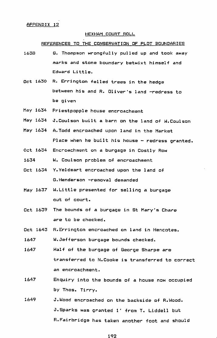
APPENDIX 12
HEX HAM CQ~RT RObh
REFERENCES TO THE CONSERVATION OF PLOT BOUNDARIES
1638 G. Thompson wrongfully pulled up and took away
marks and stone boundary betwixt himself and
Edward Little.
Oct 1630 R. Errington felled trees in the hedge
between his and R. Oliver's land -redress to
be given
May 1634 Priestpopple house encroachment
May 1634 J.Coulson built a barn on the land of W.Coulson
May 1634 A.Todd encroached upon land in the Market
Place when he built his house - redress granted.
Oct 1634 Encroachment on a burgage in Costly Row
1634 W. Coulson problem of encroachment
Oct 1634 Y.Yeldeart encroached upon the land of
G.Henderson -removal demanded
May 1637 W.Little presented for selling a burgage
out of court.
Oct 1639 The bounds of a burgage in st Mary's Chare
are to be checked.
Oct 1643 R.Errington encroached on land in Hencotes.
1647 W.Jefferson burgage bounds checked.
1647 Half of the burgage of George Sharpe are
transferred to N.Cooke is transferred to correct
an encroachment.
1647
1649
Enquiry into the bounds of a house now occupied
by Thos. Tirry.
J.Wood encroached on the backside of R.Wood.
J.Sparks was granted l' from T. Liddell but
R.Fairbridge has taken another foot and should

1650
1654
1655
1671
1673
1690
1691
replace the boundary. Borough jury called for
the resetting of a ledge between burgages
Will Marquesse encroached on the burgage of
J Soulsby in Priestpopple.
T Johnson wrongfully built a stone wall on the
ground of Will. Coulson
T Hutchinson ledge reset in R. Dobson's ground
W. Gibson encroached on J.Brown's land.
Enquiry into the ownership of a wall in
St Mary's Chare
Enquiry into the length of Ben Can's burgage
in Battlehill
R Fenwick encroached on the house of J Kirsopp
in Gilligate
How far does the garth of Cuthbert Ellwood
extend East to West and has J. Bell encroached
upon it
193

6.10.1685
13.10.1785
16,10,1789
ROTHBURY CQJ,JRT ~.QQKS - REFERENG.E TO THE
gONSERVATION OF PLOT BOUNDARIES~
w. Donkin licensed to build part of a
dwelling house near wellhouse .Three feet
beyond the boundary of his ancient freehold.
Complaints about non suits at court -
redress given
R.C.Brewer presented at court for taking
away the ancient boundary between land in
the borough of Rothbury,certain waste ground
and hath erected contiguous to his freehold
messuage/burg age and made other
encroachments.
194

EVIDENCE FOR THE EMPLOYMENT OF LAND MEASURERS -----" .... _._---_. .._ .. _--
Three land measurers appointed to help Mr A. Fenwick - they
are Thos. Gayre, Geo. Mann and Will. Fenwick.
Land Measurers ordered to get fixed bounds of Barn Garth
MQB?ETH COURT ROLL 1752
New Land Measurer Geo. Nichols sworn in.
195

BOROUGH OWNERSHIP 1900-1600
900 1000 1100 1200 1300 1400 1500 1600
ALNMOUTH DE VESCI PERCY
ALNWICK DE VESCI II
CORBRIDGE CROWN ROBERT FITZ CROWN ROGER
FELTON BERTRAM STUTEVILLE
HATL\'l SCOTLAND DEROOS MUSGRAV_E
- HARBOTTLE UMFREVILLE
HAYDON LANGLEY BRIDGE
HEX HAM ARCHBISHOP OF YORK
HOLY BISHOP OF DURHAM ISLAND
MORPETH MELRAY GREYSTOKE DACRE
NEWBIGGIN BALLIOL
NORHAM BISHOP OF DURHAM
ROTHBURY CROWN ROBERT FITZ PERCIES . CROWN ROGER
WARKWORTH CROWN " " CROWN
WOOLER MUSCHAMP CRo\~N
196

APPENDIX 16
DOCUtl~NTARY REFERENC~S TO 20' PERCH
Newminster Chartulary
P.211-2
Haec autem terra sicunt hoc ambitu continetur a latere
orientale ab acqua currit subtus Gloucestre versus aquitonem
habet longitudine lxiij perticatas, perticam xx pedum.
P.243
Parte mei dominici tofti continentem quindecim perticatas et
dimidium in longitudine, et tres perticatas in latitudine -
scit per perticam viginti pedum.
Feodorum Prioratus Dunelmensis
Willian de Grenville et patris et matris meae et omnium \
parentum meorum ecclesiam de Ellingham cum terra ad eam
pertinet et unam caractatum terrae in Cramlingtuna cum
toftus habentibus in latetude singulis iiij perticas quaram
unaquaeque habebit xx pedes, in longitudine.
e. 111
Viginti acrecum perticas xx pedum.
Quae furunt Radulfi generi Roberti, et cum vacres prati in
magno prate sub molendino de Trillesdere mensuaratis pertica
x)( pedum.
Brinkburn Chartulary
Cum omnibus pertinentiis suis perticam viginti pedum.
In super etiam in vi 11 a de Boh~enfel de I..lOam toftam
continentam V perticas in latitudine et xl in longitudine in
197

exidenteli et eustrali parte egesdem villae.
The Black Beek ef Hexham Pri~
Cemmunem pasturam ultra Birkburne quae cent. in latitudine x
perticas, xx pedum.
E~rcy Chartulary
Idem Ricardus simililer retinuit latitudinem duarum
perticatarum per pertica xx pedum.
198

GRAPHS SHOWING BURGAGE WIDTH AND FREQUENCY IN EACH OF THE
NORTHUM.PERLAND BORQUGH~ WHERE MEASUREMENTS WERE TAKEN
7 - ~
- I-
5 ,- ALNWICK BURGAGES l-
..
- I-
3 - f-
,
- I-
, - I , I -I
I I , I, I ,I, I ! I I I I
30 60 90 110 140 . FEET
- ~
.. ,
3 - ALNMOUTH BURGAGES I-
'-
- ' . r-
1 -\
r-
I I I I I I I
10 30 90 /10 130 150
199 .' "~: ; .~.: ~ ... ...... ..... .... .-.'

I I I
-
--V') UJ \..!) « \..!) ~ ::> . cx:::l
UJ \..!) a -0:::
. .' cx:::l ~-0 u
.
I I I
I -~
'.'.
l-
~
-..
~
l-
=-
-•
-
~
I -
<::) --<::)
0..1-UJ
'UJ u.
200
R -
_--J-<::) :::::
--I-~
<::) --

", . I
L 1 I ,
V') <::) UJ
'" !...... ~
'" l-e:::: ::::> cQ -UJ
~ _0 0.-
V') -~ -b ~ )
:r: -.
1-0 -.0 .
~
~
~ l-
I-
I I I I -
20\ ....... ~ ....... ..... . .
IUJ lL.J lJ...
J
V')
UJ \..J ~
'" ex: ::::> cQ
e5 c -ex: cQ
~ ~ ~
J
./
I
I-
~
--
- I-
~ -
'" I -

~...,
V'l LJ.J ,
" -" .. .-~
~ ::::> co c z a ~ ~ -.J ~
~ 0
t-:r: lJJ
Q~ '0
'~ ::
V'l LJ.J
~ a 0-. 0::
::::> .. co
< ~ a >< 'q-~ LJ.J
lJJ l.L.
~,,,--" ~
a t""\
,
202

=::::::~ . :.
r-I
-
?n~

r0-
t-
r0-
o 1"":'0 -V')
e5 r-
~ -z -t5 :J CQ
~ < -...; -~ z
« J: t-~ a r-< -
r-- ID 10--r--r-
'0
.. ~
l-
I-
I I I I --
20d

-----_ ......... .
./
,
---V'l
UJ \..? ~ « \..? e::: -:::> co >- r" e::: :::> co
§ f-.-
e::: ~
I l-
I-
.. , ~
--~
--~
--.;
-I-
-r I I I " -
205
.. ..
I I I I I ,
V'l
t5 .« \..? 0::: ::> co
¢: 0:: 0 '~ ~ 0::
~
I . I I I I I
.~\.\~:\.~:; . ":-., ..
,/'\.'
'.' ~ 'i.,
I
I
., '\' .> I .. r
!
.:-'
•
f-
f-
--~~
~
-~ --
-
- ---
r

\! !
3 WOOLER BURGAGES
I
FEET
" .
206, .. ., ... ~;- ,.,.,.\ .... ~ ~ .,' "'~"'."
- " ~, • <.' ',' > ' "
.... __ .... ~"_~ ~,~,1 ~ :' "~', ........ \. ... • ' .. ~ .... " ...... ,_~. ___ ._,_ ..... .:...>O._ ... _ ... ,.,_"'"t_ .... _...,.,~~.~~~ .. k., .... ~ ..... ~~~~4t~~"'t"!:'.~~.:"r':'.~:~

..
ARKWORTH

208
: '\ - I
\. I " . ,. t ,. - . ~:: ~ . .. ..,:: , -
, If:' "~';
:/,;,~,' .'~~ ~
'\ ~, .' ~;. . .. ; ~ - .. . ' ...... ,.
" -
ALNMOUTH

~~BREVIATIONS FPR THE BIBLIOGRAPHY
A.H.R.
A.H.
Antiq. Jour.
Archit and Arch Soc.
A.A.
Arch. Jour.
Bull. of J.R. Lib.
Cart. Jour.
Ec.H.R.
Geog. Jour.
Geog. Mag.
Geog. Rev.
1. B. G.
Jour. Hist. Geog.
M.A.
M.O.W.
N.R.O.
S~A.C.
S.G.M.
S.H.R.
S.H.S.
T.P.R.
Agricultural History Review.
Amateur Historian.
Antiquaries Journal.
Architecture and Archaeology Society.
Archaeologia Aeliana.
Archaeological Journal.
Bulletin of the John Ryland's Library.
Cartographic Journal.
Economic History Review.
Geographical Journal.
Geographical Maga2ine.
Geographical Review.
Institute of British Geographers.
Journal Of Historical Geography.
Medieval Archaeology.
Ministry of Works.
Northumberland Record Office.
Sussex Archaeological Collection.
Scottish Geographical Maga2ine.
Scottish Historical Review.
Scottish History Society.
Town Planning Review.
209

ADAMSON C.E.
ADAMSON C.E.
ADDY S.O.
ALLAUDDIN K.
ALLERSTON P.
ALLSOPP B.
CLARK W.
ANGUS W.S.
ARBUTHNOT.J
ASTON M,
BOND J.
AUSTIN D.
BIBLIOpRAPHY
The Manor of Haltwhistle in A.A. NS V 16
1894 pp162-74.
HaltwhistleD The History of the Manor
end Churc:h 1893.
Little John's Grave and the Lawful
Village Perch (Jour. Derby Arc:h.Nat.
Hist. Soc:. XLVII 1925 pp206-21.
Sc:ottish Burghs - Some Aspects of
their Origins and Development Unpubl.
B.Litt. Glasgow 1968-9.
English Village Development: Findings
from the Pic:kering Distric:t of North
Yorks. in Trans. I.B.G. 51 1970
pp95-110.
Historic Architecture of Northumberland
1969.
Anglo Saxon and Medieval Settlement
in Angus W.S. (ed) Scientific Survey of
N.E. England 1949 pp69-74.
A Table of Anc:ient Coins, Weights
and Measures 1727.
The Landsc:ape of Towns 1976.
Fieldwork and Exc:avations at Hart
County Durham in 1l:.£i: 5s IV pp69-132.
210

BAIN J(ed) The Border Papers (2 vols)
1894/6.
BAKER A.R.H. Local History and Early Estate Maps in
fh.tL Vol. 5 No.3 1962.
BALLARD A. The English Borough in the Reign of John
E.H.R. 14 1899.
BALLARD A. The Law of Breteuil in E.H.R. XXX 1915
pp646-58.
BALLARD A. The Theory of the Scottish Burgh in
S.H.R. 13 1916 p16-29.
BALLARD A. British Borough Charters 1042-1216 1913.
BALLARD A. The Domesday Boroughs 1904.
BALLARD A. The English Borough in 12th Century
1914.
BALLARD A, British Borough Charters 1216-1307 1923.
TAIT J.
BARLEY M.W. A Guide to British Topographical
Collections 1974.
BARTLETT J.N. Some Aspects of the Economy of York in
the Late Middle Ages Unpubl. PhD London
1958.
BATES C.J. The Border Lands of Northumberland
in A.A. 3s vol.XIV 1891.
BATESON M. The Laws of Breteuil in E.H.R. XV
1900 pp73-8, 302-18, 496-523, 754-757,
vol. XVI pp92-110, 332-45.
BEAN J.M.W. The Estates of the Percy Family
1416-1537 1950.
BENTON J.W. 'Town Origins - The Evidence for Medieval
England 1968.
BERESFORD M.W. New Towns of the Middle Ages 1967.
BERESFORD M.W. Medieval England 1958.
211

BERESFORD M.W.
BERESFORD M.W,
FINBERG H.P.R.
BERESFORD M.W,
HURST J.G.
BERRIMAN A.E.
BESTERMAN T.
BIDDLE M.
BIDDLE M.
BIDDLE M.
BIDDLE M.
HILL D.
HUNTER-BLAIR C.H.
HUNTER-BLAIR C.H.
HUNTER-BLAIR C.H.
HUNTER-BLAIR C.H.
BRADSHAW F.
Fallowfield: Early Cartographic
Representation' of a Deserted Village in
M.A.3 1959 pp187-215.
Medieval Boroughs: A Handlist 1973.
Wharram Percy: A Case Study in
Microtopography in P.H. Sawyer (ed)
English Medieval Settlement 1979.
Historical Metrology 1953.
A World Bibliography Of Bibliographies
Vol.2.
Archaeology And The History of British
Towns in Antiquity XLII 1968 pp109-116.
The Evolution of Planned Towns Before
1066 in Barley M.W. (ed) The Plans and
Topography of Medieval Towns in England
and Wales 1980.
Excavation At Winchester 1966 in Antig.
Jour. 1967 pp259-66.
Late Saxon Planned Towns in
Antig. Jour. 51 1971 p70-85.
Warkworth Castle M.O.W. Guide
43 1955.
The Northumbrians and their Southern
Frontiers in ~. 4th series Vol 26
pp98-126.
The Early Castles of Northumberland in
A.A. 4th series XXII 1944 ppl16-68.
Norham Castle and Church in Proc.Soc.
Antiq N/cle 45 vol.3 1927 pp45-56.
The Lay Subsidy Roll of 1296 in.fu.!!. 3s
212

BRAUN H.
BRITISH MUSEUM
BRITISH MUSEUM
BROOKS N.P.
BROOKS N.P.
WHITTINGTON G.
BUTLER L.
BUTLIN R.A
BUTLIN R.A.
CAMPBELL P.
CANT R.G.
CARTER H.
XIII 1936 pp186-302.
An Introduction to English Medieval
Architecture 1934.
The Catalogue of the Manuscript
Collection 1951.
Catalogue of Printed Map, Charts ~
Plans 15vols 1967.
Urban Archaeology in Scotland in Barley
M.W(ed) The Archaeology ~ History' of
the European town I.B.G 1977.
Planning and Growth in the Medieval
Scottish Burgh in Trans.I.B.G.
vol.2 No3 1977 pp278-95.
The Evolution of Towns -Planned Towns
After 1066 in Barley M.W. (ed) The Plans
and Topography of Medieval Towns in
England and Wales 1980.
The Development of the Irish Town 1977.
The Historical Geography of The Rural
Landscape of Northumberland Unpubl. M.A.
Liverpool 1960-61.
Two Fortified Houses in Haltwhistle
in fh...B..: 4s Vo1.48.
The Development of the Burgh of
St. Andrews in the Middle Ages in Ann.
Rept. of St. Andrews Preservation Trust
for 1970 1971 pp12-16.
The Geographical Approach in Barley
M.W(ed) The Plans and Topography
of English Medieval Towns 1980.
213

CARUS-WILSON E.M.
CHAMBERS G.E.
CHANEY H.J.
CHARLES F.W.B.
CHARLESWORTH D.
CHARLTON E.
CHENEY C.R.
CHISHOLM H.W.
CHRISTIE J.
CLAR~: G.
The First Half Century of the Borough
of Stratford upon Avon in Ec. Hist. Rev.
2s vol.18 1965 pp 46-63.
The French Bastides and The Town Plan
of Winchelsea in Arch. Jour. XCIV. 1937
pp177-206.
Our Weights and Measures:A Practical
Treatise on the Standard Weights and
Measures in use in the British Empire
1897.
Medieval Cruck Building and its
Derivatives 1967.
The Raid on Haydon Bridge 1587 in A.A.
Vol.35 1981 pp72-9.
North Tynedale -the Borders in C16th in
~. vol.5 1861.
Handbook of Dates for Students of
English History No 4 1945.
Weighing and Measurinq 1877.
Northumberland: its History Features
and People 1893.
Guide for Research Students working on
Historical Subjects 1958.
Bracing Bamburgh and The Fair Farnes
1931.
214

CLARKE H.B.
CLAR~:::E H. B.
CLAY C.T.
COLGRAVE B.
MYNORS R.
CONZEN M.R.G.
CONZEN M.R.G.
CONZEN M.R.G.
DAVIES J.C.
DAVISON W.
DICKINSON P.
DICKINSON R.E.
DICKINSON R.E.
DICKINSON R.E.
DIC~~INSON W. C.
The Topographical Development of Early
Medieval Dublin in Jour. of Royal Soc.
of Antigu of Ireland 107 1977 pp2-51.
The Medieval Town in the Modern City:
Dublin 1978.
The Ancestry of the Early Lords of
Warworth in ~. vol.32 1888 pp65-70.
Dede: Historia Ecclesiastica
1969.
Alnwick Northumberland:A Study in
Town Plan Analysis I.B.G. 27 1960.
Modern Settlement in Angus W.S(ed)
Scientific Survey of N.E. England 1949.
Geography and Townscape Conservation in
Giessener,Geographischeschr Anglo-German
Symposium in Applied Geography 1975
pp95-100.
Medieval Northumberland 1918.
A Descriptive and Historical View of
Alnwick 1822.
Th@ Historical Geography of County
Durham During the Middle Age~ Unpubl.
DPhil. Durham 1956-7.
The Development and Distribution
of the Medieval German Town in Geography
vol.27 1942.
The West European City 1951.
The Morphology of the Medieval
German Town in Geog.Rev. 35 1945.
The Early Records of the Burgh of
Aberdeen 1398-1407 in S.H.S. 1957.
215

DIC~<SON W.
DIXON D.O.
DIXON S.F.
DODD W.
DODDS M.H.
DONISTHORPE W.
DUPREE A.H.
EMMISON F.G.
EVANS C.M.
FAULKNER D.A.
FIELD N.H.
FORSTER R.
FRASER C.M.
GLASSCOCK R.E.
Four Chapters from the History of
Alnmouth 1852.
Upper Coguetdale Northumberland 1903.
History of the Saxon Royal Town of
Corbridge on Tyne 1912.
Ayr: A Study in Urban Growth in Ayr
Arch. Nat. Hist. Colla 2s vol.l0
1972 pp302-82.
The Bishops Boroughs in A.A. 3s
vol.12 1915 pp81-185.
A System of Measures of Length, Area,
Bulk, Weight, Value, Force etc 1895.
English System for Measuring Fields in
A.H.R. XLV2 1971 pp124-5.
Estate maps and Surveys in History 48
1963 pp34-7.
The Medieval Borough of Beaumarisl The
Commiote of Dindaethey 1200-1600 Unpubl.
M.A. Bangor 1949.
Medieval Undercrofts and Town Houses in
Arch. Jour. 123 1966 p120-35.
The Leaze Wimborne: An excavation in a
Deserted Medieval Quarter of the Town in
Proc. Derby. Nat. Hist. Arch. Soc. 94
1972 pp49-62.
History of Corbridge and its Antiguities
1881.
Northumberland Lay Subsidy 1296 in Proc.
Soc. Antiq. N/cle Record Series no.l
1968.
The Lay Subsidy of 1334 1975.
216

STEPHENS S.N.
GDRANSSDN S.
GRAHAM B.J.
GRAHAM B.J.
GRIERSON P.
HALL H.
HARLEY J.B.
HARLEY J.B.
PHILLIP C.B.
HARLEY J.B.
HEADLAM H.
HEMMEDN M.DE W •
• HILL D.H.
HILLABY J.
Irish Geographical studies 1970.
Morphogentic Aspects of the Agarian
Landscape in Dikos Supplementum 12 1969
pp68-78.
The Evolution of Urbanisation in
Medieval Ireland in Jour. of Hist. Geog.
vol.2 1979.
The Evolution of the Settlement Pattern
of Anglo-Norman Eastmeath in Buchannan
R.H., Butlin R.A., McCourt D. (eds)
Fields, Farms and Settlements in Europe
1976 pp38-47.
English Linear Measurements The Stenton
Lecture 1971 1972.
Select Tracts, Table Books Relating to
English Weights and Measures 1100-1742
in Cambden Miscellany XV 1929.
Maps for the Local Historian 1972.
The Historian's Guide to D.S.Maps 1964
The Settlement Geography of Early
Medieval Warwickshire in I.B.G. 34 1964
pp115-31.
Lists of Rentals ~ Surveys ~ Other
Analogus Documents in the P.R.D. 1909.
Burgage Tenure in Medieval England 1914.
The Anglo Saxon Town Unpubl. PhD
Southampton 1974-5.
The Parliamentary Borough of Weobley
1628-1709 in Woolhope Nat. Field Club
1967 p138.
217

HILLABY J.
HILLABY J.
PEARSON E.
HINDLE B.P.
HODGES C.C.
HODGES C.C.
GIBSON J.
HODGSON J.
HODGSON J.
HODGSON J.
HOPE St.John H.
HOUSTON J.M.
HUGILL R.
HUNTAR A.
HUTCHINSON R.G.A.
The Boroughs of the Bishops of Hereford
in the late C13th: with particular
reference to Ledbury in Trans. Woolhope
Nat. Field Club 1970-2 40 pp10-35.
Bromyardl A Local History 1970.
The Study of Medieval Town Plans: with
special reference to S. Shropshire.
Discussion Papers in Geography No.14
University of Salford 1981.
The Abbey of St. Andrew 1916.
Hexham and its Abbey 1919.
Northumberland 1818.
History of Northumberland in 3 parts 7
vols. 1820-58.
History of Morpeth 1832 •.
Ancient Topography of the Town of Ludlow
in Archaeologia LXI 2 1909 pp 383-8.
The Scottish Burgh in Town Planning Rev.
25 1954-5 ppl14-20.
Castles and Peles of the English Border
1970.
A Treatise of Weights and Measures for
Scotland 1624.
Topographical Notes on Bamburgh in Proc.
Soc. of Antig. N/cle 4s 3 1927 pp75-80.
218

ILLINGWORTH W.
CALEY J.
IRVINE A.
JERNINGHAM H.E.H.
JOHNS E.
JONES A.
KEENE D.J.
KIELY E.R.
KIETH G.8.
KISHIMOTO H.
LAMBERT A.M.
LANGTON J.
LEE w. LESLEY W.
LEWIS E.A.
LEY BOURN W.
LILBURN A.J.
LILBURN A.J.
LINDSAY I.
Placita de Quo Warranto Ed.I,II,III.
Morpeth: An Urban Study Unpubl. M.A.
Edin. 1962-63.
Norham Castle 1883.
British Townscapes 1965.
Land Measurement in England 1150-1350 in
A.H.R. 1979 vol.27 pp10-18.
Aspects of the N.E. Part of Medieval
Winchester with special reference to the
Brooks area Unpubl. DPhil. O~ford
1974-5.
Surveying Instrument? 1947
Tracts on Weights and Measures 1791.
Cartographic Measurements 1968.
Early Maps and Local Studies in
Geography 193 1956 p13.
Late Medieval Gloucester: Some Data from
the Rental of 1455 in I.B.G. vol.2 No.3
1977 pp259-78.
Historical Notes on Haydon Bridg~ 1876.
The History of Haltwhistle, Gilsland:
Past and Present 1922.
The Medieval Boroughs of Snowdonia 1912.
The Compleat Surveyor 1653
The Pipe Rolls of Edward I in A.A. 33
pp163-75, 39 pp327-43.
The Pipe Rolls of Edward I in Proc. Soc.
of Antig. N/cle 5s vol.1 No.7 pp261-9,
vol.1 No. 16 pp384-92.
Scottish Burgh Architecture 1948.
219

LOBEL M.D.
LOBEL M.D.
LOBEL M.D. (ed)
LOYN H.
LYNAN E.
LYONS H.G.
MADGE S.J.
MADOX T.
MAC~<ENZ IE E.
MACKENZIE W.M.
Mc:DONALD A.B.
Mc:GUINESS M.
Mc:KAY D.A.
Mc:NIVEN P.
MAITLAND F.W.
MALING D.H.
MALING D.H.
The Value of Early Maps as Evidenc:e for
the Topography of English Towns in
Immago Mund~ XXII 1968.
The Growth of Medieval England:
Town Plantations in 8eog. Jour 134 1968
pp9-81.
The Atlas of Historic: Towns vol.1 1969.
Towns in Late Anglo Saxon England in
Clemoes P. and Hughes K. England Before
the Con guest pp115-28.
The Map Makers Art 1953.
Anc:ient and Modern Land Measurements in
8eog. Teac:her vol.13 1925 pp425-32.
The Domesday of the Crown Lands 1938.
The Firma Burgi 1726.
Historic:al Topographic:al and Desc:riptive
Views of Northumberland 1825.
The Sc:ottish Borough 1949.
Extrac:ts from the Rec:ords of the Royal
Borough of Sterling 1889.
I.P.M's in A.H. 6 -:1964 pp235-41.
Medieval Boroughs in A.H. 2 1954
pp321-5.
Rebellion; Disaffec:tion in the north of
England 1403-8 unpubl. M.A. M/c: 1967-8.
Domesday Book and Beyond 1898.
How Long is a Piec:e of String in Cart.
Jour. vol.5 No.2 pp147-56.
Some Quantitative Ideas about
Cartographic:al Generalisation in Nac:hr~
a.d. Karten v Vermessungswesen R.V.
Heft,. N 5 1963.
220

MARTIN G.H.
MARTIN G.H.
MARTIN G.H.
MARTIN G.H.
MARTIN M.T.
MATTHEWS G.W.
MEYER E.F.
MILLAN J.
MONTGOMERY G.C.
MORGAN M.
MORRIS A.E.J.
MULLINS E.L.C.
MUMFORD L.
MUNDY J.H.
RIESENBERG P.
MYERS A.R. (ed)
NASH A.E.
NEWMAN L.F.
NEWTON G.
The English Borough in the C13th in
Trans R.H.S. 5s XIII 1963. ppI23-44.
The Town 1961.
The Town as Palimpsest in Dyos H.J.
(ed) The Study of Urban History 1968
pp155-69
The Borough and Merchant Community of
Ipswich 1317-1422 Unpubl. DPhil. Oxford
1955-6
Index to I.P.M's in Proc. Soc. of Antig.
N/cle 1905 3s vol.ll pp27-30.
Northumberland Tithe Award in N.R.O.
1963.
Boroughs in Willard J.F. et ala Th~
English Government at Work 1327-36 3vols
1940-50 ppl05-41.
Coins,Weights,Measures 1747
Copyhold,Eguity and Common Law 1963.
Historical Sources in Geography 1979.
The History of Urban Form 1972.
Texts and Calendars 1958.
The City in History 1961.
The Medieval Town 1958
English Historical Documents 1327-1485
1969.
Perch and Acre Sizes in Medieval Sussex
in S.A.C. 116 1978 pp57-62.
Weights and Measures in Folklore LXV
no.3 1954.
Parliamentary Surveys in History 53 1968
pp51-4.
221

NEWTON R.
NEWTON R.
NICHOLSON E.
NOBLE F.
NOBLE M.
NORDEN J.
NORDEN J.
The Northumberland Landscap@ 1972.
The Decay of the Borders in Chalkin C.W.
and Havendon M.A. Ceds) Rural Change and
Urban Growth 1974 pp2-32.
Men and Measures 1912.
Medieval Boroughs of West Herefordshire
in Trans. Wool hope Nat. Field Club 38
1964 pp62-70.
Land Tax Returns in the Investigation of
Building Processes and Morphological
Change in Small Towns in Hedon Local
Hist. Soc. No.5.
The Surveyor's Dialogue 1610.
England: An Intended Guyde for English
Travellers.
NBLD.CO.HIST.COMM. A History of Northumberland 15vols.
OFFLER H.S. Hexham: The Historia Regnum in Archit.
and Arch. Soc. of Durham and
Northumberland 2 1970 pp51-62.
OLIVER A.M. Ced) Northumberland and Durham: Deeds
OLSEN C.P.M.
OSBORN M.
PAGE W.
from Dodsworth MSS Held in the Bodleian
Library 1929.
The Older Settlements of North
Northumberland: A Studu in Geography and
History Unpubl. M.A. London 1947.
Wordsworth Borderers: The Landscape of
Penrith in Cumberland in Westmorland
Arch. Soc. 76 1976 pp154-8.
The origin and Form of Hertfordshire
Towns and Villages in Archaeologia Lxix
1917 pp47-60.
222

PALLISER D.M.
PANTIN W.A.
PEATHER N.
PETRIE F.
PEVSNER N.
PLATT C.
PLATT C.
PLATT C.
POSTAN M.M.
POWICKE M.
PRINGLE E.
PRIOR W.H.
RADLEY J.
RAINE J.
REYNOLDS S.
RICHESON A.W.
RIDPATH C.
Sources for Urban'Topography, Documents,
Buildings, Archaeology in Barley M.W.
(ad) The Plans and topography of
Medieval Towns in England and Wales
1980.
English Medieval Town House Plans in
11&.. 6 1962 pp202-40.
Mass, Time and Length 1959.
Measures and Weight~ 1934.
Northumberland: Buildings of England
1957.
The English Medieval Town 1976.
Medieval Southampton A.D. 1000-1600 1979.
The Evolution of Towns in Barley
M.W. (ed) The Plans and Topography of
Medieval Towns of England and Wales
1980.
Medieval Economy and Society 1972.
The C13th 1216-1307 1953.
The Government of the North of England
During the Reign of Henry II Unpubl.
M Litt. N/cle 1972-3.
Notes on Weights and Measures in
Medieval England 1924.
Economic Aspects of Anglo Danish York in
M.?l.15 1971 p37.
A History of North Durham 1852.
English Medieval Towns 1977.
English Land Measuring to 1800 1966.
The Border History of England and
Scotland 1776.
223

ROBERTS B. 1<.
ROBERTS B.K.
ROBERTS B.K.
ROLAND T.H.
RUSH P.
O'KEEFE J.A.
SALZMAN E.
Village Plans in County Durham in M.A.
16 1972 p33.
The Green Villages of County Durham
1977.
Rural Settlement in County Durham:
Forms, Pattern and System in Green D.,
Haselgreve C. and Spriggs M. (eds) Social
Organisation and Settlement.
Morpeth Medieval Bridge inb A.A. 2
1974 pp283-4.
Weights and Measures 1962.
Tre Legal Status of Markets in Cam~.
Hist. Jour. II pp205-12.
SANDERSON R.P. (ed) The Survey of the Debateable and Border
SAVAGE W.
SCOTT A.
SHEPPARD J.A.
SHILLABER C.
SIMMS A.
SIMPSON W.D.
SKINNER F.G.
SLATER T.R.
Lands 1604 1891.
The Making of our Towns 1952.
A Historical Guide to Rothbury 1885.
Metrological AnalYSis of Regular Village
Plans in A.H.R. 22 1974 pp118-35.
Edward I: Builder of Towns in Speculum
XXII 1947.
Medieval Dublin: A Topographical
Analysis in Irish Geog. vol.12 1979
pp25-41.
Warkworth: A Castle of Livery and
Maintenance in A.A. 4s 15 1938 ppl15-36.
Weights and Measures 1967.
The Analysis of Burgage Patterns in
Medieval Towns in Area vol.13 No.3 1981
pp211-18.
224

SLATER T.R.
SMAILES A.E.
SMAILES A.E.
SMAILES A.E.
SMAILES A.E.
SMITH C.
SMITH J.T.
STEPHENSON C.
STENTON F.M.
STOREY A.
STOREY A.
STRAW F. I.
STURDY D.A.M.
TAIT J.
TATE G.
TAYLOR E.G.R.
Urban Genesis in Medieval Town Plans in
Warwickshire and Worcestershire in
Slater T.R. and Jarvis P.J. Field and
Forest 1972 pp173-202.
The Gepgraphy of Towns 1953.
Northern England 1960.
Towns in Watson J.W. and Sissons J.B.
The British Isles 1967 pp380-403.
Some Reflections on The Geographical
Description and Analysis of Townscapes
in ~. No.21 1955 pp99-115.
Lancashire Villages Unpubl. M.A. Edin
1978-9.
A Note on the Origin of the Town Plan of
Bury St. Edmunds in Arch. Jour. 1951
pp162-4.
Borough and Town 1933.
Anglo Saxon England 1947.
Haltwhistlel A Territorial Town Unpubl.
D Phil. Notts. 1960.
Haltwhistle and South Tynedal@ 1973.
An analysis of the Town Plan of
Nottingham Unpubl. M.A. Notts. 1967-8.
The Topography of Medieval Oxforq
B Litt. Oxford 1964-65.
The English Medieval Borough 1936.
The History of Alnwick 1866.
The Surveyor in Ec.H.R. XVIII 1947.
225

TAYLOR H.M.S<J.
THOMPSON G.
TOOLEY R.V.
TOUT T.F.
TRENHOME N.M.
TWISS T.
TYSON P.
URRY W.G.
VALE M.G.A.
WADE H.O.
WATSON C.M.
WEINBAUM M.
WEINBAUM M.
WEST J.
WHITEHAND J.W.R.
ALLAUDDIN K.
WHITTINGTON G.
WILLARD J.F.
WILLARD J.F.
WILSON J.A.
WILSON M.L.
Anglo Saxon Architecture 1965.
Warkworth: Its Castle 1962.
Maps and Map Makers 1949 •.
Medieval Town Planning in Bull. of
J.R.Lib. vol.IV pp26-58.
The English Monastic Borough 1927.
Brackdon de Legibus et consuetudinibus
Angliae 1885 pp83-6.
Morpeth: An Archaeological Survey in
Clark P.A.G. and Gosling P.F.
Archaeology in the North 1976.
Canterbury Under the Angevin King~ 1967.
New Towns of the Middle Ages in Welsh
Hist. Rev.5 1970 pp72-7.
Hexham 1966.
British Weights and Measures 1910.
The Incorporation of the Boroughs 1937.
British Borough Charters 1307-1660 1943.
Village Records 1962.
The Town Plans of Scotland in S.G.M.
1969
Medieval Towns Built to Plan in Geog.
Mag. vol.57 No.8 1979.
Taxation and Parliamentary Boroughs
1933.
Parliamentary Taxes on Personal Property
1290-1334 1934.
Alnwick and the Changes it has Undergone
Since the Latter Part of the C18th 1872.
Hexham: An Analysis of the Town Plan
Unpubl. M.A. Edin. 1978-9.
226

WOOD H.
WOOD M.
WOOLER E.
WRIGHT A.B.
WRIGHT R.P.
YOUNG C.R.
Borough by Prescription: A History of
the Municipality of Tamworth 1958.
The English Medieval House 1965.
The Palatinate Boroughs of Durham in
Antiguary 1910.
An Essay Towards the History of Haxham
1823.
The Stanegate at Corbridge in A.A. 4s
vol.19 1941 p194.
The English Borough and Royal
Administration 1130-1307 1961.
227