Perspectives on Space Technology for Africa’s socio-economic development United Nations Economic...
22
Perspectives on Space Perspectives on Space Technology for Africa’s socio- Technology for Africa’s socio- economic development economic development United Nations Economic Commission for Africa ICT and Sciences & Technology Division (ISTD) Makane Faye Officer-in-charge, e@pplications Section High level conference « Space for the African Citizen High level conference « Space for the African Citizen » » 16 September 2010, Brussels 16 September 2010, Brussels
-
Upload
zachariah-henson -
Category
Documents
-
view
216 -
download
2
Transcript of Perspectives on Space Technology for Africa’s socio-economic development United Nations Economic...
Perspectives on Space Technology for Africa’s Perspectives on Space Technology for Africa’s socio-economic developmentsocio-economic development
United Nations Economic Commission for Africa
ICT and Sciences & Technology Division (ISTD)
Makane Faye
Officer-in-charge, e@pplications Section
High level conference « Space for the African Citizen »High level conference « Space for the African Citizen »16 September 2010, Brussels16 September 2010, Brussels

22www.uneca.owww.uneca.orgrg
OutlineIntroductionSpace Technology & Applications for socio-economic developmentUNECA’s support to African countries on exploitation of Space technology for socio-economic developmentThe African ICT Ministers Abuja Declaration & RecommendationsThe Committee on Development Information, Science and Technology (CODIST)Challenges on Space Technology and Applications in Africa The Way Forward

33www.uneca.owww.uneca.orgrg
Introduction
Globalization and the emerging new global economy put emphasis on information as an economic assetA major imperative in each African country is the commitment to deliver relevant information that could promote and sustain socio-economic developmentWithin its programme of Harnessing Information for Development, UNECA supports Member States in the exploitation of spatially enabled information technologies for decision-making at all levels through advisory services, capacity building and development of common resources and online repositories.

44www.uneca.owww.uneca.orgrg
Space Technology & Applications for Socio-economic development
Geospatial technology is critical to the development of the Knowledge Economy and an equitable Information SocietyIts importance lies on the fact that Location affects nearly everything we do in life and is also at the heart of some of the world’s most pressing problemsNeed for Africa to acquire orbital locations to facilitate acquisition of data & development of suitable space applicationsService delivery industries that depend on location and spatial knowledge benefit from reduced transaction costs, thus, leading to up scaling of economic activities contributing to socio-economic development

55www.uneca.owww.uneca.orgrg
Space Technology & Applications for Socio-economic development (ctd) Examples
Food Security Land cover, soil, topography,
hydrography, rainfall, demographics,
infrastructure, yield, production etc.
Water Supply Hydrography, topography, aquifers,
waterbodies, land cover, soil types,
vegetation, rainfall, etc.
Resources
Management
Ecosystems, biodiversity, vegetation,
land cover, soils, water, wetlands, biomass
etc.
Drought Rainfall, temperature, evapo-
transpiration, wind, aerosols etc.
All the information products exemplified would not be complete without the location attribute
They need to be localized: Where are the features located? Where are the population involved in an activity, vis-à-vis location of
the activity? Who will benefit from an activity or event ? Or at risk? Where are they? Where are the markets for the products? The input factors? Where are the infrastructure elements, utilities, etc? What areas are suitable (or unsuitable) for specific activities or events? How do we move (people, products, services) from source to
destination?

66www.uneca.owww.uneca.orgrg
Space Technology & Applications for Socio-economic development (ctd) Examples (ctd)
Security and
Emergency
Land cover, soil chemistry, topography,
geology, mining, utilities, settlements,
transport infrastructure, flood, etc.
Health
Planning
Hospitals locations, settlements and
demographics, disease vectors,
environmental factors distribution, etc.
E-Services
for socio-
economic
development
Telecom, market prices, demographics, e-
edcuation, e-health, e-government, e-
commerce, etc.
All the information products exemplified would not be complete without the location attribute
They need to be localized: Where are the features located? Where are the population involved in an activity, vis-à-vis location of
the activity? Who will benefit from an activity or event ? Or at risk? Where are they? Where are the markets for the products? The input factors? Where are the infrastructure elements, utilities, etc? What areas are suitable (or unsuitable) for specific activities or events? How do we move (people, products, services) from source to
destination?

77www.uneca.owww.uneca.orgrg
More examples on use of Space Technology for for Socio-economic development
Various sectors of the economy benefit significantly from access to Spatial Applications, including:
Communications in general;location/mobile services;travel and tourism;National defence;Environmental modelling; etc.
370 million Africans subscribed to mobiles in 2009 Most of the mobile are now embedded with spatial applications such as GPS and street mapsWeb-based GIS technology is also widely used in Africa

88www.uneca.owww.uneca.orgrg
UNECA Vision on Space Technology and Applications
Our Vision is to generate, share and disseminate knowledge: By ensuring that spatial data permeates every
aspect of society and that they are available to people who need them, when they need them, and in a form that they can use them to make decisions with minimal pre-processingBy ensuring that generated information is put to the maximum possible uses by publicising their existence and making them easily available to the widest possible audience

99www.uneca.owww.uneca.orgrg
Selected on-going activities
The African Regional Spatial Data Infrastructure Adopt cooperative, multi-stakeholder approach to production, management,
and dissemination of spatially enabled data: Regional and National level Improve regional scale development decision-making
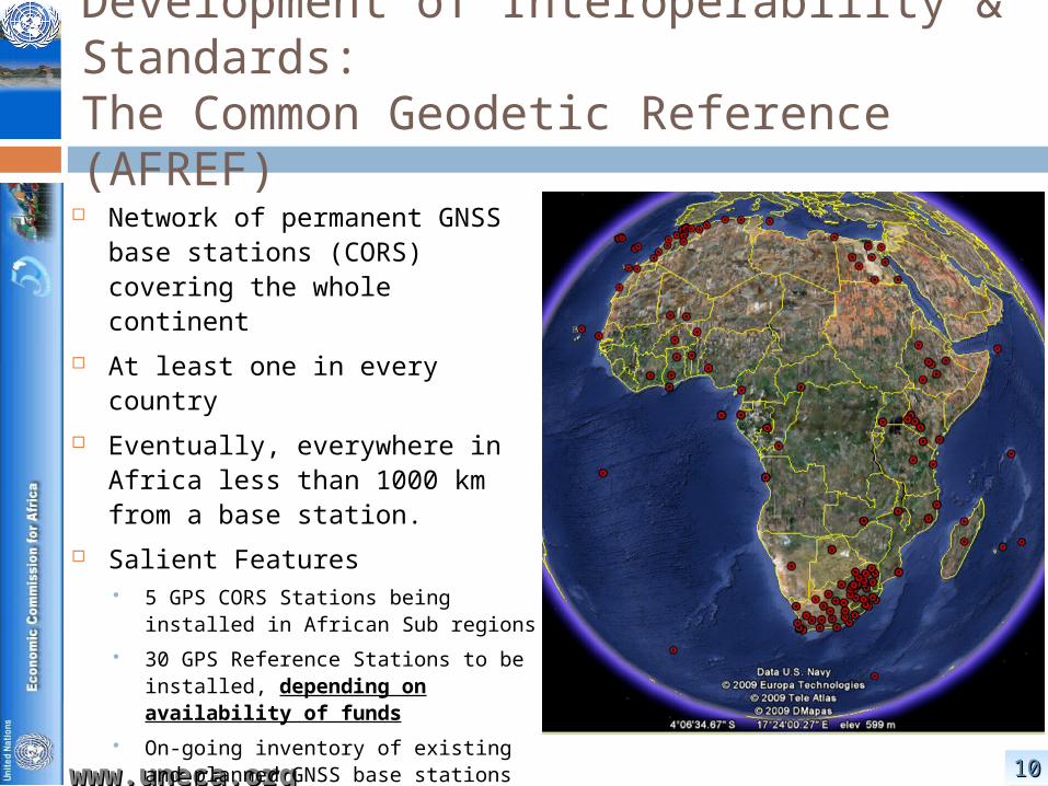
The African Geodetic Reference Frame (AFREF) Project
A scientific project using modern satellite based positioning with aim to To determine a continental reference system for Africa and to establish continuous, permanent GNSS base stations to ensure that data is freely available to all African nations
The Mapping Africa for Africa (MAfA) Initiative Based on the Durban Statement, it is a plan of action to provide the
fundamental geo-spatial information for sustainable development in support of regional projects
1010www.uneca.owww.uneca.orgrg
Development of Interoperability & Standards: The Common Geodetic Reference (AFREF)
Network of permanent GNSS base stations (CORS) covering the whole continent
At least one in every country Eventually, everywhere in Africa
less than 1000 km from a base station.
Salient Features 5 GPS CORS Stations being installed
in African Sub regions
30 GPS Reference Stations to be installed, depending on availability of funds
On-going inventory of existing and planned GNSS base stations in African countries
http://geoinfo.uneca.org/afref/

1111www.uneca.owww.uneca.orgrg
Development of Interoperability & Standards: The Harmonized Administrative Boundary
Second Administrative Level Boundary (SALB)
Produce a comprehensive digital database of Second Administrative Level Boundaries
Provide a flexible and intuitive coding scheme that can be applied to any country, independently from administrative structure an international borders template developed
by the UN Cartographic Section in order to be able to create a global data set that is cross-boundary
an editing protocol in order to insure the comparability between the countries
a coding scheme for the identification of each administrative unit through time and space
a metadata profile that is associated with the information
a validation process of all the information by an official entity (generally the National Mapping Agency
www.salb.org

1212www.uneca.owww.uneca.orgrg
Creation of Regional Databases TheTransport Infrastructure Database (TIDB)
The segments of the trans-African highway have been entered, together with proposed priority transport infrastructure projects of the various regional economic communities and specialized technical organizations. (http://geoinfo.uneca.org/afriquecentrale)
Programme of Infrastructure Development in Africa (PIDA) The database covers all existing and planned infrastructure facilities in the
continent. A compendium of maps was generated from the database and customized as an interactive digital atlas. (http://geoinfo.uneca.org/africaninfrastructure)
The African Fiber optic connectivity data base Describes international Sea connectivity and current as well as planned
connections within and between African countries. An African fiber optic map was generated. (http://geoinfo.uneca.org/downloads/Fiber%20Optic%20Network.pdf)

1313www.uneca.owww.uneca.orgrg
The Trans African Highways

1414www.uneca.owww.uneca.orgrg

1515www.uneca.owww.uneca.orgrg
e-Services Delivery (Clearinghouse Services) To use data produced by another
person/agency, potential users need to know: That the data resource
exists How the data was produced How to access the data
The metadata collections are best maintained By the producers of the data As an integral part of the data
production process But they should be accessible to
potential users Always available and easy to
access Result: on-line metadata
clearinghouse services Search and discover what
exists, where and how to access
Publish and advertise what you have and do
Field level, location and other criteria-based searches
http://geoinfo.uneca.org/

1616www.uneca.owww.uneca.orgrg
e-Services Delivery (Online Mapping)
Exploit the vast opportunities provided by the Web Make it easy and
rapid to search, and access geospatial information from multiple locations
Enable standards and interoperable web-based exploitation of Geodata
Develop value-add products and services
Decentralized Mapping…
Previously unthinkable map themes now common at demand: Visualizing MDG
Progress Dynamic maps and
Statistics… http://
geoinfo.uneca.org

1717www.uneca.owww.uneca.orgrg
Meeting of African ICT Ministers, August 2010
3rd ordinary session of the African Union ICT Ministers, held in Abuja, Nigeria, from 6-7 August 2010, adopted The Abuja 2010 Declaration, which requests the AU Commission to, enter alia, : Conduct a feasibility study on the establishment
of the African Space Agency and develop an African Space Policy in cooperation with the Regional Economic Communities (RECs), the United Nations Economic Commission for Africa (UNECA) and the International Telecommunications Union (ITU).

1818www.uneca.owww.uneca.orgrg
Meeting of African ICT Ministers, August 2010 (ctd)
Also the ministers endorsed the following recommendations from the experts: Undertake awareness raising campaigns for policy
makers; Promote the use of African Regional Centres of
Excellence to build the capacity of Member States; Provide appropriate input to African members of the
Committee on the Peaceful Uses of Outer Space; (COPUOS), in order to better take into account Africa’s concerns and needs, especially on Disaster Management, Emergency Response and peaceful use of satellite imagery;
Improve communication and coordination among existing initiatives in African countries.

1919www.uneca.owww.uneca.orgrg
Regional Coordination: CODISTRegional Coordination: CODIST
Committee on Development Information, Science and Technology
UNECA’s parliamentary body to provide technical advice on, and oversight over the ICT, Science & Technology sub programme Reports to the African Ministers of Finance and Economic
Development
Meets every two years Official delegates are government official in areas of
geographic information, space, ICT, Science and Technology Governments encouraged to include wide representation of all
stakeholders in their delegations
Observers from Private Sector, Academia, NGOs and non-African officials and industry partners

2020www.uneca.owww.uneca.orgrg
Challenges on Space Technology & Applications in Africa
Communication infrastructure not yet fully developed to support remote access to data and services
Data not available at appropriate scale, and they are not up to date
Human capacity: lack of critical mass and retention of staff
Computing resources not always available Awareness raising: decision-makers not aware of
space benefits Policy environment not yet developed

2121www.uneca.owww.uneca.orgrg
The Way Forward
Implement the Abuja 2010 Declaration and Recommendations
African Stakeholders and decision-makers to capitalize on the regularly organized Committee on Development Information, Science and Technology
UNECA & technical African organizations to secure funding from the EU to provide technical support to the AU for implementing the Abuja Declaration and the Experts recommendations