PENNSYLVANIA PIPELINE PROJECT- BECKERSVILLE …files.dep.state.pa.us/ProgramIntegration/PA Pipeline...
8
PENNSYLVANIA PIPELINE PROJECT- BECKERSVILLE STATION BRECKNOCK TOWNSHIP, BERKS COUNTY PENNSYLVANIA POST CONSTRUCTION STORMWATER MANAGEMENT PLAN NOVEMBER 2016 SUNOCO PIPELINE L.P. 525 FRITZTOWN ROAD SINKING SPRING, PENNSYLVANIA 19608 610-670-3200
-
Upload
phungkhanh -
Category
Documents
-
view
220 -
download
0
Transcript of PENNSYLVANIA PIPELINE PROJECT- BECKERSVILLE …files.dep.state.pa.us/ProgramIntegration/PA Pipeline...

PENNSYLVANIA PIPELINE PROJECT- BECKERSVILLE STATIONBRECKNOCK TOWNSHIP, BERKS COUNTY
PENNSYLVANIA
POST CONSTRUCTION STORMWATER MANAGEMENT PLAN
NOVEMBER 2016
SUNOCO PIPELINE L.P.525 FRITZTOWN ROAD
SINKING SPRING, PENNSYLVANIA 19608610-670-3200
AutoCAD SHX Text
LOCATION MAP BECKERSVILLE STATION MORGANTOWN QUADRANGLE BRECKNOCK TOWNSHIP, BERKS COUNTY, PENNSYLVANIA
AutoCAD SHX Text
DRAWING INDEX
AutoCAD SHX Text
SHEET No.
AutoCAD SHX Text
DRAWING TITLE
AutoCAD SHX Text
1 2 3 4 5 6 7 8
AutoCAD SHX Text
COVER SHEET AND NOTES OVERALL SITE PLAN PROPOSED CONDITIONS PLAN PRE-POST DEVELOPED D.A. PLAN CONSTRUCTION DETAILS BASIN #1 CONSTRUCTION DETAILS CONSTRUCTION DETAILS CONSTRUCTION DETAI
AutoCAD SHX Text
PREPARED FOR:
AutoCAD SHX Text
PREPARED BY:
AutoCAD SHX Text
PROJECT LOCATION
AutoCAD SHX Text
0
AutoCAD SHX Text
1000
AutoCAD SHX Text
2000
AutoCAD SHX Text
SCALE IN FEET
AutoCAD SHX Text
www.tetratech.com
AutoCAD SHX Text
1134 TWIN STACKS DRIVE DALLAS, PA 18612 T: (570) 674-8648 | F: (570) 674-8651 DATE: MARCH 11, 2016 COVER SHEET 1 OF 11 REVISION #1 - 4.22.16 REVISION #2 - 5.13.16 REVISION #3 - 7.01.16 REVISION #4 - 10.18.16
AutoCAD SHX Text
1-800-242-1776
AutoCAD SHX Text
CONSTRUCTION PHASE AND 10 WORKING
AutoCAD SHX Text
DAYS IN DESIGN STAGE - STOP CALL
AutoCAD SHX Text
Pennsylvania One Call System, Inc.
AutoCAD SHX Text
CALL BEFORE YOU DIG!
AutoCAD SHX Text
3 WORKING DAYS NOTICE FOR
AutoCAD SHX Text
PENNSYLVANIA LAW REQUIRES
AutoCAD SHX Text
AS PER F.E.M.A. MAPPING, FIRM PANEL 629 OF 700,
AutoCAD SHX Text
5. NO PORTION OF THE SITE LIES WITHIN ANY 100 YEAR FLOOD ZONES,
AutoCAD SHX Text
4. EXISTING CONTOURS AND FEATURES COMPILED FROM WWW.PASDA.PSU.EDU.
AutoCAD SHX Text
3. PUBLIC SEWER AND WATER WILL NOT BE PROVIDED. THE FACILITY IS UNMANNED.
AutoCAD SHX Text
6. THERE ARE NO WETLANDS WITHIN THE DISTURBED AREA OF THE SITE.
AutoCAD SHX Text
SUNOCO PIPELINE, LP
AutoCAD SHX Text
2. CURRENT TAX IDENTIFICATION #: 34-5302-02-56-2952
AutoCAD SHX Text
1. DEVELOPER/ OWNER:
AutoCAD SHX Text
GENERAL NOTES
AutoCAD SHX Text
MAP #42011C0629G, EFFECTIVE DATE IS 06/03/2012.
AutoCAD SHX Text
7. THE ASSOCIATED STORM WATER MANAGEMENT REPORT FOR THIS PROJECT IS TITLED:
AutoCAD SHX Text
EROSION AND SEDIMENTATION CONTROL PLAN PENNSYLVANIA PIPELINE PROJECT BECKERSVILLE STATION EXPANSION ACTIVITIES BRECKNOCK TOWNSHIP BERKS COUNTY, PA MARCH, 2016
AutoCAD SHX Text
8. THE SITE LIES WITHIN A 50%%% RELEASE RATE DISTRICT OF THE CONESTOGA RIVER
AutoCAD SHX Text
ACT 167 STORMWATER MANAGEMENT PLAN.
AutoCAD SHX Text
TOTAL PARCEL SIZE = 17.45 AC
AutoCAD SHX Text
9. UN-NAMED TRIBUTARY TO MUDDY CREEK IS LISTED AS "HQ-TSF" UNDER CHAPTER 93.
AutoCAD SHX Text
INSTRUMENT #2014027505, RECORDED 8-25-2014
AutoCAD SHX Text
525 FRITZTOWN ROAD
AutoCAD SHX Text
SINKING SPRING, PA. 19608
AutoCAD SHX Text
SCALE:1"=1000'
AutoCAD SHX Text
610-670-3200
AutoCAD SHX Text
10. THE PADOT DRIVEWAY HOP NO. 05048641 WAS ISSUED ON 7/17/2014.
AutoCAD SHX Text
KACHEL RD
AutoCAD SHX Text
DIEHL RD
AutoCAD SHX Text
SHEA DR
AutoCAD SHX Text
SPECK RD
AutoCAD SHX Text
11. SUNOCO LOGISTICS PARTNERS, LP WILL BE RESPONSIBLE FOR PERMANENT INSPECTION
AutoCAD SHX Text
AND MAINTENANCE OF ALL STORMWATER MANAGEMENT FACILITIES.
AutoCAD SHX Text
EXISTING CONTOURS ARE BASED ON NAVD 88 DATUM.
AutoCAD SHX Text
TIMOTHY J. CONNOLLY JR.,P.E. DATE
AutoCAD SHX Text
1134 TWIN STACKS DRIVE, DALLAS, PA. 18612
AutoCAD SHX Text
PE-39066-E
AutoCAD SHX Text
ENGINEER IN THE COMMONWEALTH OF PENNSYLVANIA,
AutoCAD SHX Text
ACCURATE, TO THE BEST OF MY KNOWLEDGE.
AutoCAD SHX Text
PLANS AND SUPPORTING DOCUMENTATION ARE TRUE AND
AutoCAD SHX Text
DOES HEREBY CERTIFY THAT THE ACCOMPANYING APPLICATION,
AutoCAD SHX Text
I, TIMOTHY J. CONNOLLY JR.,P.E., A LICENSED PROFESSIONAL
AutoCAD SHX Text
ENGINEER CERTIFICATION
AutoCAD SHX Text
17. LADDER RUNGS SHALL BE PROVIDED FOR ALL STORM SEWER INLETS AND MANHOLES
AutoCAD SHX Text
WITH A DEPTH OF 4 FEET OR GREATER.
AutoCAD SHX Text
18. ALL STORM MANHOLES SHALL HAVE THE WORD "STORM" CAST ON THE TOP MANHOLE COVER.
AutoCAD SHX Text
TIMOTHY J. CONNOLLY JR.,P.E. DATE
AutoCAD SHX Text
UNDERLAIN BY CARBONATE GEOLOGY.
AutoCAD SHX Text
CERTIFY THAT THE PROPOSED DETENTION BASIN IS NOT
AutoCAD SHX Text
I, TIMOTHY J. CONNOLLY JR.,P.E.,
AutoCAD SHX Text
TIMOTHY J. CONNOLLY JR.,P.E. DATE
AutoCAD SHX Text
STANDARDS AND CRITERIA OF THE BRECKNOCK TOWNSHIP
AutoCAD SHX Text
HEREBY CERTIFIES THAT THE DRAINAGE PLAN MEETS ALL DESIGN
AutoCAD SHX Text
I, TIMOTHY J. CONNOLLY JR.,P.E., ON THIS DATE
AutoCAD SHX Text
STORMWATER MANAGEMENT ORDINANCE
AutoCAD SHX Text
SUNOCO PIPELINE L.P. DATE
AutoCAD SHX Text
BE APPROVED BY THE TOWNSHIP AND THE BERKS CO.
AutoCAD SHX Text
ANY REVISION TO THE APPROVED DRAINAGE PLAN MUST
AutoCAD SHX Text
SUNOCO PIPELINE L.P. ACKNOWLEDGES THAT
AutoCAD SHX Text
CONSERVATION DISTRICT
AutoCAD SHX Text
TIMOTHY J. CONNOLLY JR.,P.E. DATE
AutoCAD SHX Text
SEDIMENT CONTROL MEET THE REQUIREMENTS, STANDARDS
AutoCAD SHX Text
HEREBY CERTIFY THAT THE PLAN FOR SOIL EROSION AND
AutoCAD SHX Text
I, TIMOTHY J. CONNOLLY JR.,P.E.,
AutoCAD SHX Text
AND SPECIFICATIONS OF THE COUNTY CONSERVATION DISTRICT.
AutoCAD SHX Text
10/18/2016
AutoCAD SHX Text
EXISTING LIGHT POLE, LITHONIA STSH 30 6-4B SQUARE TAPERED STEEL HINGED LIGHT POLE (6.41"x 3.08" RECT. x 30' TALL) FROM ME-1 PHASE. NO LIGHTS PROPOSED IN PPP PHASE.
AutoCAD SHX Text
12. BRECKNOCK TOWNSHIP AND ITS AUTHORIZED AGENTS HAVE THE RIGHT, BUT NOT THE
AutoCAD SHX Text
DUTY TO ENTER THE PROPERTY TO PERFORM INSPECTIONS OF STORMWATER FACILITIES.
AutoCAD SHX Text
13. THE EXISTING WELL AND SEPTIC SYSTEM ON THE PARCEL WILL BE ABANDONED IN
AutoCAD SHX Text
ACCORDANCE WITH DEP AND TOWNSHIP REGULATIONS, IF THE BUILDING IS DEMOLISHED.
AutoCAD SHX Text
ACCESS AND INSPECTIONS WITHIN THE SECURED AREA CAN ONLY BE COMPLETED WITH
AutoCAD SHX Text
AUTHORIZED REPRESENTATIVES OF THE PROPERTY OWNER.
AutoCAD SHX Text
14. SITE LIGHTING WILL BE ACCOMPLISHED WITH POLE MOUNTED FIXTURES.
AutoCAD SHX Text
LIGHTS WILL REMAIN IN THE "OFF" POSITION UNLESS NIGHTTIME WORK IS ANTICIPATED.
AutoCAD SHX Text
15. THERE ARE NO ADVERTISING SIGNS PROPOSED FOR THIS SITE.
AutoCAD SHX Text
IT IS REQUIRED BY BRECKNOCK TOWNSHIP THAT ALL SITE LIGHTING SHALL REMAIN IN THE OFF MODE DURING ALL NIGHT TIME HOURS. THE SITE LIGHTING SHALL BE DESIGNED TO BE MANUALLY OPERATED BY SUNOCO PERSONNEL ONLY WHEN NECESSARY DURING NIGHT TIME HOURS OF OPERATION WHEN SUNOCO PERSONNEL ARE ON-SITE.
AutoCAD SHX Text
16.
AutoCAD SHX Text
10/18/2016
AutoCAD SHX Text
10/18/2016
AutoCAD SHX Text
10/18/2016
AutoCAD SHX Text
735
AutoCAD SHX Text
PROPOSED CONTOURS
AutoCAD SHX Text
EXISTING CONTOURS
AutoCAD SHX Text
730
AutoCAD SHX Text
PRE-DEV DA BOUNDARY
AutoCAD SHX Text
POST-DEV DA BOUNDARY
AutoCAD SHX Text
LOD/ESCGP-2 BOUNDARY = 5.985 AC
AutoCAD SHX Text
%%ULEGEND
AutoCAD SHX Text
RRA#2
AutoCAD SHX Text
PADOT TYPE M PRECAST INLET
AutoCAD SHX Text
4' DIA. PADOT PRECAST STORM MH
AutoCAD SHX Text
STORM PIPE W/ FES
AutoCAD SHX Text
RIPRAP APRON
AutoCAD SHX Text
8' HEIGHT "SIMTEK" FENCE
AutoCAD SHX Text
SETBACK LINE
AutoCAD SHX Text
PROPERTY LINE
AutoCAD SHX Text
EXISTING R/W
AutoCAD SHX Text
SOIL BOUNDARY
AutoCAD SHX Text
JnC
AutoCAD SHX Text
Tc FLOW PATH

SOILS LIMITATIONS
SOIL LIMITATION RESOLUTIONS
All soils within the site are suitable for the intended use. Any topsoil needed in the area can be imported from off-site
areas. All soil groups are within acceptable limits of pH reaction. All soils within this project have a slight erosion hazard.
However, erosion control blankets (S-150) will be placed on all slopes at 3:1 or steeper. None of the soils on site are
susceptible to sinkholes. All storm pipes are backfilled with select material, and all proposed storm pipes will havewatertight connections. All pipe to inlet connections will also be grouted to remain watertight. Embankments for thedetention basin will be compacted to 95% density.
TOPSOIL SPECIFICATIONS: All topsoil to be imported to the site shall meet the requirements of Section 802 of PADOT
Form 408 specifications. The material shall meet the following grading requirements:
Sieve Min. % passing
2 in. 100 %
No. 4 75 %
No. 10 60 %
Sand, silt and clay material passing the No. 10 sieve, as defined by PTM No. 103, and within the following ranges:
Min. % Max %
Sand 5 70
Silt 10 70
Clay 5 36
SOILS ANALYSISExisting soils on site include the following:JpD - Joanna loam, 8-25%, Depth to Bedrock = 72-100 inchesErosion Hazard = SlightJnC - Joanna loam, 8-15%, Depth to Bedrock = 72-100 inchesErosion Hazard = SlightAbA - Abbottstown silt loam, 0-3%, Depth to Bedrock = 40-60 inchesErosion Hazard = Slight
AutoCAD SHX Text
STEEL PIPE
AutoCAD SHX Text
STEEL PIPE
AutoCAD SHX Text
N 54°06'22" W
AutoCAD SHX Text
300.000'
AutoCAD SHX Text
N 24°15'00" E (R)
AutoCAD SHX Text
SAUTER, ROBERT W & SANDRA S.
AutoCAD SHX Text
BK. 4062 PG. 1242
AutoCAD SHX Text
25.24'
AutoCAD SHX Text
N75%%D23'53"E
AutoCAD SHX Text
N 19%%D09'58" E (M)
AutoCAD SHX Text
41.88'
AutoCAD SHX Text
S80%%D13'49"E
AutoCAD SHX Text
105.94'
AutoCAD SHX Text
S 85%%D12'08" E
AutoCAD SHX Text
ODEBISI, FATAI T.
AutoCAD SHX Text
BK. 3196 PG. 1419
AutoCAD SHX Text
LEWANDOWSKI, B.L.
AutoCAD SHX Text
INST # 2012030998
AutoCAD SHX Text
ZIEGLER, ALBERT R
AutoCAD SHX Text
BK. 1665 PG. 701
AutoCAD SHX Text
16.224 ACRES
AutoCAD SHX Text
POLLAK, LOUIS H. & KATHERINE W.
AutoCAD SHX Text
EXISTING SUNOCO PIPELINE R/W
AutoCAD SHX Text
REBAR FOUND
AutoCAD SHX Text
BK04860 PG2434
AutoCAD SHX Text
LAUVER, L.S. & N.F.
AutoCAD SHX Text
MOYER, M.E. & M.E.
AutoCAD SHX Text
V2343 PG1770
AutoCAD SHX Text
EXISTING SUNOCO PIPELINE R/W
AutoCAD SHX Text
740
AutoCAD SHX Text
730
AutoCAD SHX Text
EX. TREE LINE
AutoCAD SHX Text
JpD
AutoCAD SHX Text
JnC
AutoCAD SHX Text
AbA
AutoCAD SHX Text
JpB
AutoCAD SHX Text
JnB
AutoCAD SHX Text
JpD
AutoCAD SHX Text
730
AutoCAD SHX Text
STONE
AutoCAD SHX Text
S24%%D05'01"E 470.39'(M)
AutoCAD SHX Text
S64%%D29'10"W (M)
AutoCAD SHX Text
70.00'
AutoCAD SHX Text
S 21°45'00" E
AutoCAD SHX Text
485.10' (R)
AutoCAD SHX Text
N 63°00'00" W
AutoCAD SHX Text
2268.75' (R)
AutoCAD SHX Text
REBAR FOUND
AutoCAD SHX Text
IP FOUND
AutoCAD SHX Text
IP FOUND
AutoCAD SHX Text
S21°30'00"E 465.30'(R)
AutoCAD SHX Text
176.85'
AutoCAD SHX Text
N89%%D06'46"E
AutoCAD SHX Text
R=674.85'
AutoCAD SHX Text
L=161.32'
AutoCAD SHX Text
S69°30'00"W (R)
AutoCAD SHX Text
N 65%%D35'01" W
AutoCAD SHX Text
2268.75' (M)
AutoCAD SHX Text
S 24%%D23'36" E
AutoCAD SHX Text
496.68' (M)
AutoCAD SHX Text
729.89'
AutoCAD SHX Text
R=5555.04'
AutoCAD SHX Text
L=531.07'
AutoCAD SHX Text
ALLEGHENYVILLE
AutoCAD SHX Text
ROAD
AutoCAD SHX Text
SUNOCO PIPELINE. LP
AutoCAD SHX Text
INSTRUMENT # 2014027505
AutoCAD SHX Text
17 AC - 147 PERCHES (R)
AutoCAD SHX Text
17.444 AC (M)
AutoCAD SHX Text
ASH, THOMAS
AutoCAD SHX Text
BK. 5391 PG. 1504
AutoCAD SHX Text
13.072 ACRES
AutoCAD SHX Text
GLASFORD, DONALD E. & NATALIE V.
AutoCAD SHX Text
733.0
AutoCAD SHX Text
733.0
AutoCAD SHX Text
734.4
AutoCAD SHX Text
EXISTING HOME
AutoCAD SHX Text
OVERHEAD UTILITY
AutoCAD SHX Text
#62107 (HQ-TSF)
AutoCAD SHX Text
UN-NAMED TRIB. TO
AutoCAD SHX Text
EXIST +/- 50' WIDTH PIPELINE R/W
AutoCAD SHX Text
700
AutoCAD SHX Text
720
AutoCAD SHX Text
750
AutoCAD SHX Text
SR 3024
AutoCAD SHX Text
EX. DRIVE
AutoCAD SHX Text
EX. DRIVE
AutoCAD SHX Text
EX. DRIVE
AutoCAD SHX Text
12' CARTWAY
AutoCAD SHX Text
12' CARTWAY
AutoCAD SHX Text
3%%% SLOPE
AutoCAD SHX Text
DEED BOOK 125, PAGE 330
AutoCAD SHX Text
700
AutoCAD SHX Text
690
AutoCAD SHX Text
680
AutoCAD SHX Text
670
AutoCAD SHX Text
660
AutoCAD SHX Text
650
AutoCAD SHX Text
640
AutoCAD SHX Text
630
AutoCAD SHX Text
620
AutoCAD SHX Text
610
AutoCAD SHX Text
690
AutoCAD SHX Text
680
AutoCAD SHX Text
670
AutoCAD SHX Text
660
AutoCAD SHX Text
650
AutoCAD SHX Text
640
AutoCAD SHX Text
630
AutoCAD SHX Text
620
AutoCAD SHX Text
610
AutoCAD SHX Text
B
AutoCAD SHX Text
B
AutoCAD SHX Text
B
AutoCAD SHX Text
B
AutoCAD SHX Text
B
AutoCAD SHX Text
B
AutoCAD SHX Text
B
AutoCAD SHX Text
B
AutoCAD SHX Text
B
AutoCAD SHX Text
B
AutoCAD SHX Text
B
AutoCAD SHX Text
B
AutoCAD SHX Text
B
AutoCAD SHX Text
B
AutoCAD SHX Text
B
AutoCAD SHX Text
B
AutoCAD SHX Text
B
AutoCAD SHX Text
B
AutoCAD SHX Text
B
AutoCAD SHX Text
B
AutoCAD SHX Text
710
AutoCAD SHX Text
ALLEGHENYVILLE ROAD
AutoCAD SHX Text
EX. DRIVE
AutoCAD SHX Text
750
AutoCAD SHX Text
740
AutoCAD SHX Text
720
AutoCAD SHX Text
730
AutoCAD SHX Text
RECORDING DATE: 8-25-2014
AutoCAD SHX Text
x
AutoCAD SHX Text
EX. FENCE LINE
AutoCAD SHX Text
SETBACK LINE
AutoCAD SHX Text
740
AutoCAD SHX Text
EX. DRIVE
AutoCAD SHX Text
PROPERTY LINE
AutoCAD SHX Text
TB #1 SURF. ELEV.=711.0 TEST ELEV.=708.0 RATE=0.16 IN/HR
AutoCAD SHX Text
TB #2 SURF. ELEV.=712.0 TEST ELEV.=704.0 RATE=0.08 IN/HR
AutoCAD SHX Text
EXISTING PAD AREA
AutoCAD SHX Text
EXISTING DRIVE
AutoCAD SHX Text
EX. PUMP BLDG
AutoCAD SHX Text
EX. PDC
AutoCAD SHX Text
EX. FLARE
AutoCAD SHX Text
EXIST. HOME
AutoCAD SHX Text
EXISTING DRIVE
AutoCAD SHX Text
WOODED AREA TO REMAIN
AutoCAD SHX Text
730
AutoCAD SHX Text
730
AutoCAD SHX Text
TB #C SURF. ELEV.=691.0 TEST ELEV.=687.5 RATE=0.12 IN/HR
AutoCAD SHX Text
720
AutoCAD SHX Text
720
AutoCAD SHX Text
720
AutoCAD SHX Text
720
AutoCAD SHX Text
710
AutoCAD SHX Text
700
AutoCAD SHX Text
690
AutoCAD SHX Text
740
AutoCAD SHX Text
TB #A SURF. ELEV.=726.0 TEST ELEV.=722.5 PIT BOTTOM=720.5 RATE=1.88 IN/HR
AutoCAD SHX Text
TB #B SURF. ELEV.=725.0 TEST ELEV.=722.0 PIT BOTTOM=720.0 RATE=0.00 IN/HR
AutoCAD SHX Text
TB #D SURF. ELEV.=689.0 TEST ELEV.=686.0 PIT BOTTOM=684.0 RATE=3.38 IN/HR
AutoCAD SHX Text
736
AutoCAD SHX Text
734
AutoCAD SHX Text
MARK
AutoCAD SHX Text
DATE
AutoCAD SHX Text
DESCRIPTION
AutoCAD SHX Text
BY
AutoCAD SHX Text
SCALE:
AutoCAD SHX Text
CHECKED BY:
AutoCAD SHX Text
PROJECT NO.:
AutoCAD SHX Text
DRAWN BY:
AutoCAD SHX Text
www.tetratech.com
AutoCAD SHX Text
1134 TWIN STACKS DRIVE DALLAS, PA 18612 T: (570) 674-8648 | F: (570) 674-8651
AutoCAD SHX Text
NAME:
AutoCAD SHX Text
DATE:
AutoCAD SHX Text
COPYRIGHT TETRA TECH INC.
AutoCAD SHX Text
FILE:
AutoCAD SHX Text
OF
AutoCAD SHX Text
03/11/16
AutoCAD SHX Text
212IC-PB-00136
AutoCAD SHX Text
GZ
AutoCAD SHX Text
TC
AutoCAD SHX Text
1"=100'
AutoCAD SHX Text
BASEPLAN
AutoCAD SHX Text
OVERALL 2
AutoCAD SHX Text
PPP - BECKERSVILLE PUMP STATION
AutoCAD SHX Text
BRECKNOCK TOWNSHIP, BERKS COUNTY
AutoCAD SHX Text
PCSM PLAN - OVERALL SITE
AutoCAD SHX Text
2
AutoCAD SHX Text
8
AutoCAD SHX Text
MAGNETIC
AutoCAD SHX Text
0
AutoCAD SHX Text
100
AutoCAD SHX Text
200
AutoCAD SHX Text
SCALE: 1"=100'
AutoCAD SHX Text
PROPERTY BOUNDARY LINES AS PER ALTA SURVEY COMPLETED BY TRICO SURVEYING, 441 W. GOURLEY PIKE, BLOOMINGTON, IN 47404
AutoCAD SHX Text
2
AutoCAD SHX Text
5/13/16
AutoCAD SHX Text
REVISED PER LTL LETTER (4/20/16)
AutoCAD SHX Text
GZ
AutoCAD SHX Text
1
AutoCAD SHX Text
4/22/16
AutoCAD SHX Text
REVISED PER EXISTING SURVEY
AutoCAD SHX Text
GZ
AutoCAD SHX Text
3
AutoCAD SHX Text
7/01/16
AutoCAD SHX Text
REVISED PER LTL LETTER (6/7/16)
AutoCAD SHX Text
GZ
AutoCAD SHX Text
4
AutoCAD SHX Text
10/18/16
AutoCAD SHX Text
REVISED PER PA DEP REVIEW
AutoCAD SHX Text
GZ
AutoCAD SHX Text
735
AutoCAD SHX Text
PROPOSED CONTOURS
AutoCAD SHX Text
EXISTING CONTOURS
AutoCAD SHX Text
730
AutoCAD SHX Text
PRE-DEV DA BOUNDARY
AutoCAD SHX Text
POST-DEV DA BOUNDARY
AutoCAD SHX Text
LOD/ESCGP-2 BOUNDARY = 5.985 AC
AutoCAD SHX Text
%%ULEGEND
AutoCAD SHX Text
RRA#2
AutoCAD SHX Text
PADOT TYPE M PRECAST INLET
AutoCAD SHX Text
4' DIA. PADOT PRECAST STORM MH
AutoCAD SHX Text
STORM PIPE W/ FES
AutoCAD SHX Text
RIPRAP APRON
AutoCAD SHX Text
8' HEIGHT "SIMTEK" FENCE
AutoCAD SHX Text
SETBACK LINE
AutoCAD SHX Text
PROPERTY LINE
AutoCAD SHX Text
EXISTING R/W
AutoCAD SHX Text
SOIL BOUNDARY
AutoCAD SHX Text
JnC
AutoCAD SHX Text
Tc FLOW PATH
AutoCAD SHX Text
740
AutoCAD SHX Text
730
AutoCAD SHX Text
730
AutoCAD SHX Text
734.0
AutoCAD SHX Text
733.0
AutoCAD SHX Text
733.0
AutoCAD SHX Text
734.4
AutoCAD SHX Text
EXISTING HOME
AutoCAD SHX Text
OVERHEAD UTILITY
AutoCAD SHX Text
#62107 (HQ-TSF)
AutoCAD SHX Text
UN-NAMED TRIB. TO
AutoCAD SHX Text
700
AutoCAD SHX Text
720
AutoCAD SHX Text
750
AutoCAD SHX Text
SR 3024
AutoCAD SHX Text
EX. DRIVE
AutoCAD SHX Text
EX. DRIVE
AutoCAD SHX Text
EX. DRIVE
AutoCAD SHX Text
12' CARTWAY
AutoCAD SHX Text
12' CARTWAY
AutoCAD SHX Text
3%%% SLOPE
AutoCAD SHX Text
700
AutoCAD SHX Text
690
AutoCAD SHX Text
680
AutoCAD SHX Text
670
AutoCAD SHX Text
660
AutoCAD SHX Text
650
AutoCAD SHX Text
640
AutoCAD SHX Text
690
AutoCAD SHX Text
680
AutoCAD SHX Text
670
AutoCAD SHX Text
660
AutoCAD SHX Text
650
AutoCAD SHX Text
640
AutoCAD SHX Text
630
AutoCAD SHX Text
620
AutoCAD SHX Text
PROPOSED TREE LINE
AutoCAD SHX Text
B
AutoCAD SHX Text
B
AutoCAD SHX Text
B
AutoCAD SHX Text
B
AutoCAD SHX Text
B
AutoCAD SHX Text
B
AutoCAD SHX Text
B
AutoCAD SHX Text
B
AutoCAD SHX Text
B
AutoCAD SHX Text
B
AutoCAD SHX Text
B
AutoCAD SHX Text
B
AutoCAD SHX Text
B
AutoCAD SHX Text
B
AutoCAD SHX Text
B
AutoCAD SHX Text
B
AutoCAD SHX Text
B
AutoCAD SHX Text
B
AutoCAD SHX Text
B
AutoCAD SHX Text
B
AutoCAD SHX Text
710
AutoCAD SHX Text
ALLEGHENYVILLE ROAD
AutoCAD SHX Text
EX. DRIVE
AutoCAD SHX Text
750
AutoCAD SHX Text
740
AutoCAD SHX Text
720
AutoCAD SHX Text
730
AutoCAD SHX Text
x
AutoCAD SHX Text
EX. FENCE LINE
AutoCAD SHX Text
SETBACK LINE
AutoCAD SHX Text
740
AutoCAD SHX Text
PROPERTY LINE
AutoCAD SHX Text
MH #1 RIM=712.0 INV.=706.5
AutoCAD SHX Text
HW #1 INV.=711.0
AutoCAD SHX Text
INLET #2 RIM=731.5 INV.=722.0
AutoCAD SHX Text
INLET #1 RIM=731.5 INV.=726.0
AutoCAD SHX Text
EX. ST. MH RIM=626.0 INV.=615.0
AutoCAD SHX Text
EX. RRA INV.=614.1
AutoCAD SHX Text
EX. ST. MH RIM=653.0 INV.=646.0
AutoCAD SHX Text
BASIN OUTLET RIM=690.0 INV.=686.0
AutoCAD SHX Text
EXISTING PAD AREA
AutoCAD SHX Text
EX. RRA INV.=718.0
AutoCAD SHX Text
EX. ST. MH RIM=723.0 INV.=719.0
AutoCAD SHX Text
EX. INL. RIM=729.0 INV.=725.0
AutoCAD SHX Text
EX. BASIN #1
AutoCAD SHX Text
ME-2 PIPING
AutoCAD SHX Text
EX. PUMP BLDG
AutoCAD SHX Text
EX. PDC
AutoCAD SHX Text
EX. FLARE
AutoCAD SHX Text
RELOCATED
AutoCAD SHX Text
GATE
AutoCAD SHX Text
FLARE
AutoCAD SHX Text
KNOCK OUT
AutoCAD SHX Text
DRUM
AutoCAD SHX Text
PROPOSED DRIVE IMPROVEMENTS
AutoCAD SHX Text
RELOCATED FENCE LINE
AutoCAD SHX Text
EX.FENCE TO BE REMOVED
AutoCAD SHX Text
TIE NEW FENCE INTO EXIST.
AutoCAD SHX Text
TREES TO REMAIN
AutoCAD SHX Text
TIE NEW FENCE INTO EXIST.
AutoCAD SHX Text
RELOCATED FENCE LINE
AutoCAD SHX Text
EXIST. HOME
AutoCAD SHX Text
P-1
AutoCAD SHX Text
P-2
AutoCAD SHX Text
P-3
AutoCAD SHX Text
EXISTING STONE DRIVE
AutoCAD SHX Text
686
AutoCAD SHX Text
692
AutoCAD SHX Text
692
AutoCAD SHX Text
690
AutoCAD SHX Text
688
AutoCAD SHX Text
686
AutoCAD SHX Text
684
AutoCAD SHX Text
MH #4 RIM=660.0 INV.=653.8
AutoCAD SHX Text
686
AutoCAD SHX Text
690
AutoCAD SHX Text
PROP.BASIN #2
AutoCAD SHX Text
MH #3 RIM=684.0 INV.=678.0
AutoCAD SHX Text
MH #2 RIM=702.0 INV.=688.0
AutoCAD SHX Text
CHANNEL #2
AutoCAD SHX Text
P-6
AutoCAD SHX Text
P-4
AutoCAD SHX Text
P-5
AutoCAD SHX Text
P-7
AutoCAD SHX Text
LOD ON ME2 PLANS=5.985 AC
AutoCAD SHX Text
730
AutoCAD SHX Text
730
AutoCAD SHX Text
720
AutoCAD SHX Text
720
AutoCAD SHX Text
720
AutoCAD SHX Text
720
AutoCAD SHX Text
710
AutoCAD SHX Text
700
AutoCAD SHX Text
690
AutoCAD SHX Text
740
AutoCAD SHX Text
RRA #1 INV.=686.0
AutoCAD SHX Text
694
AutoCAD SHX Text
INLET #3 RIM=715.0 INV.=710.5
AutoCAD SHX Text
P-8
AutoCAD SHX Text
P-9
AutoCAD SHX Text
CHANNEL #1
AutoCAD SHX Text
WOODED AREA TO REMAIN
AutoCAD SHX Text
RRA #2 INV.=710.0
AutoCAD SHX Text
734
AutoCAD SHX Text
736
AutoCAD SHX Text
744
AutoCAD SHX Text
732
AutoCAD SHX Text
730
AutoCAD SHX Text
720
AutoCAD SHX Text
714
AutoCAD SHX Text
718
AutoCAD SHX Text
736
AutoCAD SHX Text
734
AutoCAD SHX Text
ALL BASIN SIDE SLOPES SHALL BE LINED WITH NA GREEN S-150 EROSION CONTROL BLANKETS.
AutoCAD SHX Text
CHANNEL #1
AutoCAD SHX Text
EMERGENCY SPILLWAY
AutoCAD SHX Text
MARK
AutoCAD SHX Text
DATE
AutoCAD SHX Text
DESCRIPTION
AutoCAD SHX Text
BY
AutoCAD SHX Text
SCALE:
AutoCAD SHX Text
CHECKED BY:
AutoCAD SHX Text
PROJECT NO.:
AutoCAD SHX Text
DRAWN BY:
AutoCAD SHX Text
www.tetratech.com
AutoCAD SHX Text
1134 TWIN STACKS DRIVE DALLAS, PA 18612 T: (570) 674-8648 | F: (570) 674-8651
AutoCAD SHX Text
NAME:
AutoCAD SHX Text
DATE:
AutoCAD SHX Text
COPYRIGHT TETRA TECH INC.
AutoCAD SHX Text
FILE:
AutoCAD SHX Text
OF
AutoCAD SHX Text
03/11/16
AutoCAD SHX Text
212IC-PB-00136
AutoCAD SHX Text
GZ
AutoCAD SHX Text
TC
AutoCAD SHX Text
1"=50'
AutoCAD SHX Text
BASEPLAN
AutoCAD SHX Text
PROP 3
AutoCAD SHX Text
PPP - BECKERSVILLE PUMP STATION
AutoCAD SHX Text
BRECKNOCK TOWNSHIP, BERKS COUNTY
AutoCAD SHX Text
PCSM PLAN - PROPOSED CONDITIONS
AutoCAD SHX Text
3
AutoCAD SHX Text
8
AutoCAD SHX Text
MAGNETIC
AutoCAD SHX Text
0
AutoCAD SHX Text
50
AutoCAD SHX Text
100
AutoCAD SHX Text
SCALE: 1"=50'
AutoCAD SHX Text
2
AutoCAD SHX Text
5/13/16
AutoCAD SHX Text
REVISED PER LTL LETTER (4/20/16)
AutoCAD SHX Text
GZ
AutoCAD SHX Text
1
AutoCAD SHX Text
4/22/16
AutoCAD SHX Text
REVISED PER EXISTING SURVEY
AutoCAD SHX Text
GZ
AutoCAD SHX Text
3
AutoCAD SHX Text
7/01/16
AutoCAD SHX Text
REVISED PER LTL LETTER (6/7/16)
AutoCAD SHX Text
GZ
AutoCAD SHX Text
4
AutoCAD SHX Text
10/18/16
AutoCAD SHX Text
REVISED PER PA DEP REVIEW
AutoCAD SHX Text
GZ
AutoCAD SHX Text
%%UPROPOSED STORM PIPE TABLE
AutoCAD SHX Text
ALL INLETS ARE PADOT TYPE M PRECAST CONCRETE.
AutoCAD SHX Text
ALL STORM PIPE IS SLCPP, ADS-N12 OR APPROVED EQUAL.
AutoCAD SHX Text
ALL MANHOLES ARE 4' DIAMETER PRECAST CONCRETE.
AutoCAD SHX Text
ALL STORM INLETS AND MANHOLES MUST HAVE LADDER RUNGS ALL MANHOLES SHALL HAVE THE WORD "STORM" ON COVER.
AutoCAD SHX Text
ALL INLETS SHALL CONTAIN A PAINTED MARKER THAT STATES, "NO DUMPING, DISCHARGES TO STREAMS".
AutoCAD SHX Text
FOR PIPE P-6, USE RCCP.
AutoCAD SHX Text
735
AutoCAD SHX Text
PROPOSED CONTOURS
AutoCAD SHX Text
EXISTING CONTOURS
AutoCAD SHX Text
730
AutoCAD SHX Text
PRE-DEV DA BOUNDARY
AutoCAD SHX Text
POST-DEV DA BOUNDARY
AutoCAD SHX Text
LOD/ESCGP-2 BOUNDARY = 5.985 AC
AutoCAD SHX Text
%%ULEGEND
AutoCAD SHX Text
RRA#2
AutoCAD SHX Text
PADOT TYPE M PRECAST INLET
AutoCAD SHX Text
4' DIA. PADOT PRECAST STORM MH
AutoCAD SHX Text
STORM PIPE W/ FES
AutoCAD SHX Text
RIPRAP APRON
AutoCAD SHX Text
8' HEIGHT "SIMTEK" FENCE
AutoCAD SHX Text
SETBACK LINE
AutoCAD SHX Text
PROPERTY LINE
AutoCAD SHX Text
EXISTING R/W
AutoCAD SHX Text
SOIL BOUNDARY
AutoCAD SHX Text
JnC
AutoCAD SHX Text
Tc FLOW PATH
AutoCAD SHX Text
STEEL PIPE
AutoCAD SHX Text
STEEL PIPE
AutoCAD SHX Text
740
AutoCAD SHX Text
730
AutoCAD SHX Text
POST-DEVELOPED D.A.=3.317 ACRES
AutoCAD SHX Text
2.872 AC - POST DEV
AutoCAD SHX Text
POST DEV
AutoCAD SHX Text
730
AutoCAD SHX Text
734.0
AutoCAD SHX Text
733.0
AutoCAD SHX Text
733.0
AutoCAD SHX Text
734.4
AutoCAD SHX Text
EXISTING HOME
AutoCAD SHX Text
OVERHEAD UTILITY
AutoCAD SHX Text
#62107 (HQ-TSF)
AutoCAD SHX Text
UN-NAMED TRIB. TO
AutoCAD SHX Text
EXIST. POND
AutoCAD SHX Text
EXIST +/- 50' WIDTH PIPELINE R/W
AutoCAD SHX Text
700
AutoCAD SHX Text
720
AutoCAD SHX Text
750
AutoCAD SHX Text
SR 3024
AutoCAD SHX Text
EX. DRIVE
AutoCAD SHX Text
EX. DRIVE
AutoCAD SHX Text
EX. DRIVE
AutoCAD SHX Text
12' CARTWAY
AutoCAD SHX Text
12' CARTWAY
AutoCAD SHX Text
3%%% SLOPE
AutoCAD SHX Text
DEED BOOK 125, PAGE 330
AutoCAD SHX Text
700
AutoCAD SHX Text
690
AutoCAD SHX Text
680
AutoCAD SHX Text
670
AutoCAD SHX Text
660
AutoCAD SHX Text
650
AutoCAD SHX Text
640
AutoCAD SHX Text
630
AutoCAD SHX Text
620
AutoCAD SHX Text
610
AutoCAD SHX Text
690
AutoCAD SHX Text
680
AutoCAD SHX Text
670
AutoCAD SHX Text
660
AutoCAD SHX Text
650
AutoCAD SHX Text
640
AutoCAD SHX Text
630
AutoCAD SHX Text
620
AutoCAD SHX Text
610
AutoCAD SHX Text
PROPOSED TREE LINE
AutoCAD SHX Text
B
AutoCAD SHX Text
B
AutoCAD SHX Text
B
AutoCAD SHX Text
B
AutoCAD SHX Text
B
AutoCAD SHX Text
B
AutoCAD SHX Text
B
AutoCAD SHX Text
B
AutoCAD SHX Text
B
AutoCAD SHX Text
B
AutoCAD SHX Text
B
AutoCAD SHX Text
B
AutoCAD SHX Text
B
AutoCAD SHX Text
B
AutoCAD SHX Text
B
AutoCAD SHX Text
B
AutoCAD SHX Text
B
AutoCAD SHX Text
B
AutoCAD SHX Text
B
AutoCAD SHX Text
B
AutoCAD SHX Text
710
AutoCAD SHX Text
ALLEGHENYVILLE ROAD
AutoCAD SHX Text
EX. DRIVE
AutoCAD SHX Text
750
AutoCAD SHX Text
740
AutoCAD SHX Text
720
AutoCAD SHX Text
730
AutoCAD SHX Text
x
AutoCAD SHX Text
EX. FENCE LINE
AutoCAD SHX Text
SETBACK LINE
AutoCAD SHX Text
740
AutoCAD SHX Text
PROPERTY LINE
AutoCAD SHX Text
MH #1 RIM=712.0 INV.=706.5
AutoCAD SHX Text
HW #1 INV.=711.0
AutoCAD SHX Text
INLET #2 RIM=731.5 INV.=722.0
AutoCAD SHX Text
INLET #1 RIM=731.5 INV.=726.0
AutoCAD SHX Text
EX. ST. MH RIM=626.0 INV.=615.0
AutoCAD SHX Text
EX. RRA INV.=614.1
AutoCAD SHX Text
EX. ST. MH RIM=653.0 INV.=646.0
AutoCAD SHX Text
BASIN OUTLET RIM=690.0 INV.=686.0
AutoCAD SHX Text
EXISTING PAD AREA
AutoCAD SHX Text
EX. RRA INV.=718.0
AutoCAD SHX Text
EX. ST. MH RIM=723.0 INV.=719.0
AutoCAD SHX Text
EX. INL. RIM=729.0 INV.=725.0
AutoCAD SHX Text
EX. BASIN #1
AutoCAD SHX Text
ME-2 PIPING
AutoCAD SHX Text
EX. PUMP BLDG
AutoCAD SHX Text
EX. PDC
AutoCAD SHX Text
EX. FLARE
AutoCAD SHX Text
RELOCATED
AutoCAD SHX Text
GATE
AutoCAD SHX Text
FLARE
AutoCAD SHX Text
KNOCK OUT
AutoCAD SHX Text
DRUM
AutoCAD SHX Text
PROPOSED DRIVE IMPROVEMENTS
AutoCAD SHX Text
RELOCATED FENCE LINE
AutoCAD SHX Text
EX.FENCE TO BE REMOVED
AutoCAD SHX Text
TIE NEW FENCE INTO EXIST.
AutoCAD SHX Text
TREES TO REMAIN
AutoCAD SHX Text
TIE NEW FENCE INTO EXIST.
AutoCAD SHX Text
RELOCATED FENCE LINE
AutoCAD SHX Text
EXIST. HOME
AutoCAD SHX Text
P-1
AutoCAD SHX Text
P-2
AutoCAD SHX Text
P-3
AutoCAD SHX Text
EXISTING STONE DRIVE
AutoCAD SHX Text
686
AutoCAD SHX Text
692
AutoCAD SHX Text
692
AutoCAD SHX Text
690
AutoCAD SHX Text
688
AutoCAD SHX Text
686
AutoCAD SHX Text
684
AutoCAD SHX Text
MH #4 RIM=660.0 INV.=653.8
AutoCAD SHX Text
686
AutoCAD SHX Text
690
AutoCAD SHX Text
PROP.BASIN #2
AutoCAD SHX Text
MH #3 RIM=684.0 INV.=678.0
AutoCAD SHX Text
MH #2 RIM=702.0 INV.=688.0
AutoCAD SHX Text
CHANNEL #2
AutoCAD SHX Text
P-6
AutoCAD SHX Text
P-4
AutoCAD SHX Text
P-5
AutoCAD SHX Text
P-7
AutoCAD SHX Text
UNDETAINED D.A. #1=0.254 AC.
AutoCAD SHX Text
730
AutoCAD SHX Text
730
AutoCAD SHX Text
720
AutoCAD SHX Text
720
AutoCAD SHX Text
720
AutoCAD SHX Text
720
AutoCAD SHX Text
710
AutoCAD SHX Text
700
AutoCAD SHX Text
690
AutoCAD SHX Text
740
AutoCAD SHX Text
RRA #1 INV.=686.0
AutoCAD SHX Text
694
AutoCAD SHX Text
CHANNEL #1 DA=0.523 AC.
AutoCAD SHX Text
CHANNEL #2 DA=0.413 AC.
AutoCAD SHX Text
INLET #3 RIM=715.0 INV.=710.5
AutoCAD SHX Text
P-8
AutoCAD SHX Text
P-9
AutoCAD SHX Text
CHANNEL #1
AutoCAD SHX Text
WOODED AREA TO REMAIN
AutoCAD SHX Text
RRA #2 INV.=710.0
AutoCAD SHX Text
POST-DEV FLOW PATH
AutoCAD SHX Text
POST-DEV FLOW PATH
AutoCAD SHX Text
734
AutoCAD SHX Text
736
AutoCAD SHX Text
744
AutoCAD SHX Text
732
AutoCAD SHX Text
730
AutoCAD SHX Text
720
AutoCAD SHX Text
714
AutoCAD SHX Text
718
AutoCAD SHX Text
736
AutoCAD SHX Text
734
AutoCAD SHX Text
ALL BASIN SIDE SLOPES SHALL BE LINED WITH NA GREEN S-150 EROSION CONTROL BLANKETS.
AutoCAD SHX Text
CHANNEL #1
AutoCAD SHX Text
EMERGENCY SPILLWAY
AutoCAD SHX Text
740
AutoCAD SHX Text
730
AutoCAD SHX Text
EX. TREE LINE
AutoCAD SHX Text
PRE-DEVELOPED D.A.=3.571 ACRES
AutoCAD SHX Text
730
AutoCAD SHX Text
733.0
AutoCAD SHX Text
733.0
AutoCAD SHX Text
734.4
AutoCAD SHX Text
EXISTING HOME
AutoCAD SHX Text
OVERHEAD UTILITY
AutoCAD SHX Text
#62107 (HQ-TSF)
AutoCAD SHX Text
UN-NAMED TRIB. TO
AutoCAD SHX Text
700
AutoCAD SHX Text
720
AutoCAD SHX Text
750
AutoCAD SHX Text
SR 3024
AutoCAD SHX Text
EX. DRIVE
AutoCAD SHX Text
EX. DRIVE
AutoCAD SHX Text
EX. DRIVE
AutoCAD SHX Text
12' CARTWAY
AutoCAD SHX Text
12' CARTWAY
AutoCAD SHX Text
3%%% SLOPE
AutoCAD SHX Text
700
AutoCAD SHX Text
690
AutoCAD SHX Text
680
AutoCAD SHX Text
670
AutoCAD SHX Text
660
AutoCAD SHX Text
650
AutoCAD SHX Text
640
AutoCAD SHX Text
630
AutoCAD SHX Text
620
AutoCAD SHX Text
610
AutoCAD SHX Text
690
AutoCAD SHX Text
680
AutoCAD SHX Text
670
AutoCAD SHX Text
660
AutoCAD SHX Text
650
AutoCAD SHX Text
640
AutoCAD SHX Text
630
AutoCAD SHX Text
620
AutoCAD SHX Text
610
AutoCAD SHX Text
B
AutoCAD SHX Text
B
AutoCAD SHX Text
B
AutoCAD SHX Text
B
AutoCAD SHX Text
B
AutoCAD SHX Text
B
AutoCAD SHX Text
B
AutoCAD SHX Text
B
AutoCAD SHX Text
B
AutoCAD SHX Text
B
AutoCAD SHX Text
B
AutoCAD SHX Text
B
AutoCAD SHX Text
B
AutoCAD SHX Text
B
AutoCAD SHX Text
B
AutoCAD SHX Text
B
AutoCAD SHX Text
B
AutoCAD SHX Text
B
AutoCAD SHX Text
B
AutoCAD SHX Text
B
AutoCAD SHX Text
710
AutoCAD SHX Text
ALLEGHENYVILLE ROAD
AutoCAD SHX Text
EX. DRIVE
AutoCAD SHX Text
750
AutoCAD SHX Text
740
AutoCAD SHX Text
720
AutoCAD SHX Text
730
AutoCAD SHX Text
x
AutoCAD SHX Text
EX. FENCE LINE
AutoCAD SHX Text
740
AutoCAD SHX Text
EX. DRIVE
AutoCAD SHX Text
PROPERTY LINE
AutoCAD SHX Text
EXISTING PAD AREA
AutoCAD SHX Text
EXISTING DRIVE
AutoCAD SHX Text
EX. PUMP BLDG
AutoCAD SHX Text
EX. PDC
AutoCAD SHX Text
EX. FLARE
AutoCAD SHX Text
EXIST. HOME
AutoCAD SHX Text
EXISTING DRIVE
AutoCAD SHX Text
WOODED AREA TO REMAIN
AutoCAD SHX Text
730
AutoCAD SHX Text
730
AutoCAD SHX Text
720
AutoCAD SHX Text
720
AutoCAD SHX Text
720
AutoCAD SHX Text
720
AutoCAD SHX Text
710
AutoCAD SHX Text
700
AutoCAD SHX Text
690
AutoCAD SHX Text
740
AutoCAD SHX Text
PRE-DEV FLOW PATH
AutoCAD SHX Text
PRE-DEV FLOW PATH
AutoCAD SHX Text
PRE-DEV DA BOUNDARY
AutoCAD SHX Text
736
AutoCAD SHX Text
734
AutoCAD SHX Text
MARK
AutoCAD SHX Text
DATE
AutoCAD SHX Text
DESCRIPTION
AutoCAD SHX Text
BY
AutoCAD SHX Text
SCALE:
AutoCAD SHX Text
CHECKED BY:
AutoCAD SHX Text
PROJECT NO.:
AutoCAD SHX Text
DRAWN BY:
AutoCAD SHX Text
www.tetratech.com
AutoCAD SHX Text
1134 TWIN STACKS DRIVE DALLAS, PA 18612 T: (570) 674-8648 | F: (570) 674-8651
AutoCAD SHX Text
NAME:
AutoCAD SHX Text
DATE:
AutoCAD SHX Text
COPYRIGHT TETRA TECH INC.
AutoCAD SHX Text
FILE:
AutoCAD SHX Text
OF
AutoCAD SHX Text
03/11/16
AutoCAD SHX Text
212IC-PB-00136
AutoCAD SHX Text
GZ
AutoCAD SHX Text
TC
AutoCAD SHX Text
1"=100'
AutoCAD SHX Text
BASEPLAN
AutoCAD SHX Text
DA 5
AutoCAD SHX Text
PPP - BECKERSVILLE PUMP STATION
AutoCAD SHX Text
BRECKNOCK TOWNSHIP, BERKS COUNTY
AutoCAD SHX Text
PCSM PLAN - PRE-POST DEVELOPED D.A.
AutoCAD SHX Text
4
AutoCAD SHX Text
8
AutoCAD SHX Text
MAGNETIC
AutoCAD SHX Text
0
AutoCAD SHX Text
100
AutoCAD SHX Text
200
AutoCAD SHX Text
SCALE: 1"=100'
AutoCAD SHX Text
PRE-DEVELOPED D.A. MAP - ME2 STATION
AutoCAD SHX Text
SCALE: 1"=100'
AutoCAD SHX Text
POST-DEVELOPED D.A. MAP - ME2 STATION
AutoCAD SHX Text
SCALE: 1"=100'
AutoCAD SHX Text
2
AutoCAD SHX Text
5/13/16
AutoCAD SHX Text
REVISED PER LTL LETTER (4/20/16)
AutoCAD SHX Text
GZ
AutoCAD SHX Text
1
AutoCAD SHX Text
4/22/16
AutoCAD SHX Text
REVISED PER EXISTING SURVEY
AutoCAD SHX Text
GZ
AutoCAD SHX Text
3
AutoCAD SHX Text
7/01/16
AutoCAD SHX Text
REVISED PER LTL LETTER (6/7/16)
AutoCAD SHX Text
GZ
AutoCAD SHX Text
4
AutoCAD SHX Text
10/18/16
AutoCAD SHX Text
REVISED PER PA DEP REVIEW
AutoCAD SHX Text
GZ
AutoCAD SHX Text
735
AutoCAD SHX Text
PROPOSED CONTOURS
AutoCAD SHX Text
EXISTING CONTOURS
AutoCAD SHX Text
730
AutoCAD SHX Text
PRE-DEV DA BOUNDARY
AutoCAD SHX Text
POST-DEV DA BOUNDARY
AutoCAD SHX Text
LOD/ESCGP-2 BOUNDARY = 5.985 AC
AutoCAD SHX Text
%%ULEGEND
AutoCAD SHX Text
RRA#2
AutoCAD SHX Text
PADOT TYPE M PRECAST INLET
AutoCAD SHX Text
4' DIA. PADOT PRECAST STORM MH
AutoCAD SHX Text
STORM PIPE W/ FES
AutoCAD SHX Text
RIPRAP APRON
AutoCAD SHX Text
8' HEIGHT "SIMTEK" FENCE
AutoCAD SHX Text
SETBACK LINE
AutoCAD SHX Text
PROPERTY LINE
AutoCAD SHX Text
EXISTING R/W
AutoCAD SHX Text
SOIL BOUNDARY
AutoCAD SHX Text
JnC
AutoCAD SHX Text
Tc FLOW PATH

AutoCAD SHX Text
MARK
AutoCAD SHX Text
DATE
AutoCAD SHX Text
DESCRIPTION
AutoCAD SHX Text
BY
AutoCAD SHX Text
SCALE:
AutoCAD SHX Text
CHECKED BY:
AutoCAD SHX Text
PROJECT NO.:
AutoCAD SHX Text
DRAWN BY:
AutoCAD SHX Text
www.tetratech.com
AutoCAD SHX Text
1134 TWIN STACKS DRIVE DALLAS, PA 18612 T: (570) 674-8648 | F: (570) 674-8651
AutoCAD SHX Text
NAME:
AutoCAD SHX Text
DATE:
AutoCAD SHX Text
COPYRIGHT TETRA TECH INC.
AutoCAD SHX Text
FILE:
AutoCAD SHX Text
OF
AutoCAD SHX Text
03/11/16
AutoCAD SHX Text
212IC-PB-00136
AutoCAD SHX Text
GZ
AutoCAD SHX Text
TC
AutoCAD SHX Text
AS NOTED
AutoCAD SHX Text
BASEPLAN
AutoCAD SHX Text
CONSTDET5
AutoCAD SHX Text
PPP - BECKERSVILLE PUMP STATION
AutoCAD SHX Text
BRECKNOCK TOWNSHIP, BERKS COUNTY
AutoCAD SHX Text
PCSM PLAN - PIPE PROFILES
AutoCAD SHX Text
5
AutoCAD SHX Text
8
AutoCAD SHX Text
DATUM: 610
AutoCAD SHX Text
EX. RRA INV.=614.1
AutoCAD SHX Text
EX. ST. MH. RIM=653.0 INV.=646.0
AutoCAD SHX Text
EX. ST. MH. RIM=626.0 INV.=615.0
AutoCAD SHX Text
EX/24'/15" SLCPP @ 3.75%
AutoCAD SHX Text
EX/106'/15" SLCPP @ 29.25%
AutoCAD SHX Text
%%USTORM PROFILE
AutoCAD SHX Text
HORIZ: 1"=20'
AutoCAD SHX Text
VERT: 1"=20'
AutoCAD SHX Text
SCALE:
AutoCAD SHX Text
DATUM: 700
AutoCAD SHX Text
MH #1 RIM=712.0 INV.=706.5
AutoCAD SHX Text
P-3/22'/15" SLCPP @ 20.45%
AutoCAD SHX Text
HW #1 INV.=711.0
AutoCAD SHX Text
A
AutoCAD SHX Text
%%USECTION A-A
AutoCAD SHX Text
1 1/2"
AutoCAD SHX Text
2 1/2"
AutoCAD SHX Text
%%USECTION B-B
AutoCAD SHX Text
1 1/2"
AutoCAD SHX Text
24"
AutoCAD SHX Text
8"
AutoCAD SHX Text
B
AutoCAD SHX Text
A
AutoCAD SHX Text
36"
AutoCAD SHX Text
1 1/2"
AutoCAD SHX Text
1 1/4"X1 1/4"X1/8"(MIN.)
AutoCAD SHX Text
6"
AutoCAD SHX Text
NOT TO SCALE
AutoCAD SHX Text
%%UTYPE M INLET
AutoCAD SHX Text
B
AutoCAD SHX Text
2 1/2"
AutoCAD SHX Text
1 1/2"
AutoCAD SHX Text
GRATE (STRUCTURAL STEEL SHOWN)
AutoCAD SHX Text
INLET BOX
AutoCAD SHX Text
CONCRETE TOP UNIT - TYPE M
AutoCAD SHX Text
GRADE ADJUSTMENT RING, SEE NOTE 4.
AutoCAD SHX Text
TYPE M CONCRETE TOP UNIT
AutoCAD SHX Text
PRECAST MANHOLE
AutoCAD SHX Text
BASE PREPARATION
AutoCAD SHX Text
2. PLACE SUBBASE MATERIAL MEETING THE REQUIREMENTS OF PUBLICATION 408,
AutoCAD SHX Text
SECTION 350.2, IN LAYERS 100 (4") THICK, COMPACTED TO A DENSITY
AutoCAD SHX Text
SATISFACTORY TO THE ENGINEER AND INCIDENTAL TO THE MANHOLE PAY ITEM.
AutoCAD SHX Text
TYPICAL BASE SECTION
AutoCAD SHX Text
TOP AND BOTTOM
AutoCAD SHX Text
STEEL
AutoCAD SHX Text
TYPICAL FLAT TOP SECTION
AutoCAD SHX Text
USED FOR SHALLOW FILL PIPES.
AutoCAD SHX Text
ADJUST TO FINAL GRADE WITH
AutoCAD SHX Text
PRECAST CONCRETE GRADE RINGS
AutoCAD SHX Text
MAXIMUM 305 (12") TOTAL
AutoCAD SHX Text
THICKNESS.
AutoCAD SHX Text
VARIABLE HEIGHT
AutoCAD SHX Text
230
AutoCAD SHX Text
(9")
AutoCAD SHX Text
BASE
AutoCAD SHX Text
4x12-W4xW1.7 WWF
AutoCAD SHX Text
LIP REINFORCEMENT
AutoCAD SHX Text
2-#16 (#5) BARS
AutoCAD SHX Text
#16 (#5) BARS
AutoCAD SHX Text
203
AutoCAD SHX Text
(8")
AutoCAD SHX Text
4x12-W4xW1.7 WWF
AutoCAD SHX Text
LIP REINFORCEMENT
AutoCAD SHX Text
1219 (48")
AutoCAD SHX Text
129
AutoCAD SHX Text
129
AutoCAD SHX Text
(5")
AutoCAD SHX Text
(5")
AutoCAD SHX Text
B
AutoCAD SHX Text
B
AutoCAD SHX Text
SECTION B-B
AutoCAD SHX Text
1. PRECAST MANHOLES MEETING THE REQUIREMENTS OF PUBLICATION 408,
AutoCAD SHX Text
SECTION 714, MAY BE SUBSTITUTED FOR THE STANDARD CAST-IN-PLACE
AutoCAD SHX Text
MANHOLE. FOR DEVIATION OR MODIFICATION OF THE STANDARDS, SUBMIT
AutoCAD SHX Text
SHOP DRAWINGS FOR APPROVAL.
AutoCAD SHX Text
PRECAST MANHOLE
AutoCAD SHX Text
WITH FLAT TOP
AutoCAD SHX Text
610 (24") MIN TO
AutoCAD SHX Text
762 (30") MAX ID
AutoCAD SHX Text
40
AutoCAD SHX Text
(11/2")
AutoCAD SHX Text
CLR
AutoCAD SHX Text
2-#16 (#5) TYP
AutoCAD SHX Text
610 (24") MIN TO
AutoCAD SHX Text
762 (30") MAX ID
AutoCAD SHX Text
SUBBASE MATERIAL
AutoCAD SHX Text
300 (12") MIN,
AutoCAD SHX Text
SEE NOTE 2
AutoCAD SHX Text
#16 (#5)
AutoCAD SHX Text
@ 150 (6") C TO C
AutoCAD SHX Text
EACH WAY
AutoCAD SHX Text
NOTES
AutoCAD SHX Text
2
AutoCAD SHX Text
5/13/16
AutoCAD SHX Text
REVISED PER LTL LETTER (4/20/16)
AutoCAD SHX Text
GZ
AutoCAD SHX Text
1
AutoCAD SHX Text
4/22/16
AutoCAD SHX Text
REVISED PER EXISTING SURVEY
AutoCAD SHX Text
GZ
AutoCAD SHX Text
3
AutoCAD SHX Text
7/01/16
AutoCAD SHX Text
REVISED PER LTL LETTER (6/7/16)
AutoCAD SHX Text
GZ
AutoCAD SHX Text
4
AutoCAD SHX Text
10/18/16
AutoCAD SHX Text
REVISED PER PA DEP REVIEW
AutoCAD SHX Text
GZ
AutoCAD SHX Text
EX/35'/15" SLCPP @ 22.29%
AutoCAD SHX Text
P-7/181'/15" SLCPP @ 13.37%
AutoCAD SHX Text
P-6/125'/15" SLCPP @ 6.40%
AutoCAD SHX Text
ST. MH. 4 RIM=660.0 INV.=653.8
AutoCAD SHX Text
ST. MH. 3 RIM=684.0 INV.=678.0
AutoCAD SHX Text
BASIN OUTLET RIM=690.0 INV.=686.0
AutoCAD SHX Text
DATUM: 700
AutoCAD SHX Text
RRA 2 INV.=710.0
AutoCAD SHX Text
P-9/22'/15" SLCPP @ 2.27%
AutoCAD SHX Text
P-8/52'/15" SLCPP @ 16.35%
AutoCAD SHX Text
EX. PIPE/52'/15" SLCPP @ 11.54%
AutoCAD SHX Text
INL. 3 RIM=715.0 INV.=710.5
AutoCAD SHX Text
EX. ST. MH. RIM=723.0 INV.=719.0
AutoCAD SHX Text
EX. INL. RIM=729.0 INV.=725.0
AutoCAD SHX Text
DATUM: 680
AutoCAD SHX Text
RRA 1 INV.=686.0
AutoCAD SHX Text
P-5/125'/15" SLCPP @ 1.60%
AutoCAD SHX Text
ST. MH. 2 RIM=702.0 INV.=688.0
AutoCAD SHX Text
ST. MH. 1 RIM=712.0 INV.=706.5
AutoCAD SHX Text
INL. 2 RIM=731.5 INV.=722.0
AutoCAD SHX Text
INL. 1 RIM=731.5 INV.=726.0
AutoCAD SHX Text
P-4/78'/15" SLCPP @ 23.72%
AutoCAD SHX Text
P-2/49'/15" SLCPP @ 31.63%
AutoCAD SHX Text
P-1/65'/15" SLCPP @ 6.15%
AutoCAD SHX Text
P-4/78'/15" SLCPP @ 23.72%
STANDARD CONSTRUCTION DETAIL #9-1
RIPRAP APRON AT PIPE OUTLET
WITH FLARED END SECTION OR ENDWALL
STANDARD CONSTRUCTION DETAIL #7-16
CONCRETE ANTI-SEEP COLLAR FOR
PERMANENT BASINS OR TRAPS
STANDARD CONSTRUCTION DETAIL #7-13
BASIN EMERGENCY SPILLWAY WITH TRM LINING
AutoCAD SHX Text
MARK
AutoCAD SHX Text
DATE
AutoCAD SHX Text
DESCRIPTION
AutoCAD SHX Text
BY
AutoCAD SHX Text
SCALE:
AutoCAD SHX Text
CHECKED BY:
AutoCAD SHX Text
PROJECT NO.:
AutoCAD SHX Text
DRAWN BY:
AutoCAD SHX Text
www.tetratech.com
AutoCAD SHX Text
1134 TWIN STACKS DRIVE DALLAS, PA 18612 T: (570) 674-8648 | F: (570) 674-8651
AutoCAD SHX Text
NAME:
AutoCAD SHX Text
DATE:
AutoCAD SHX Text
COPYRIGHT TETRA TECH INC.
AutoCAD SHX Text
FILE:
AutoCAD SHX Text
OF
AutoCAD SHX Text
03/11/16
AutoCAD SHX Text
212IC-PB-00136
AutoCAD SHX Text
GZ
AutoCAD SHX Text
TC
AutoCAD SHX Text
AS NOTED
AutoCAD SHX Text
BASEPLAN
AutoCAD SHX Text
CONSTDET6
AutoCAD SHX Text
PPP - BECKERSVILLE PUMP STATION
AutoCAD SHX Text
BRECKNOCK TOWNSHIP, BERKS COUNTY
AutoCAD SHX Text
PCSM PLAN - CONSTRUCTION DETAILS
AutoCAD SHX Text
6
AutoCAD SHX Text
8
AutoCAD SHX Text
2:1
AutoCAD SHX Text
%%USECTION THRU DETENTION/INFILTRATION BASIN #2
AutoCAD SHX Text
2:1
AutoCAD SHX Text
10' WIDE
AutoCAD SHX Text
TOP OF BERM=692.0
AutoCAD SHX Text
TOP OF BERM = 692.0
AutoCAD SHX Text
2:1
AutoCAD SHX Text
CREST = 690.0
AutoCAD SHX Text
SPILLWAY - DET. BASIN
AutoCAD SHX Text
6.0' WIDE
AutoCAD SHX Text
6' WIDE SPILLWAY @ ELEV. 690.0
AutoCAD SHX Text
NO SCALE
AutoCAD SHX Text
EXIST. GRADE
AutoCAD SHX Text
BASIN INV. = 686.0
AutoCAD SHX Text
MAX ELEV=687.65
AutoCAD SHX Text
MAX 100 YR ELEV=687.65
AutoCAD SHX Text
NOTES: 1. ALL EMBANKMENTS SHALL BE PLACED IN A MAXIMUM 8" LIFTS TO A MINIMUM OF 95% OF MAXIMUM DRY DENSITY AS ESTABLISHED BY ASTM D-1557.
AutoCAD SHX Text
BASIN OUTLET STRUCTURE (PADOT TYPE "M" INLET)
AutoCAD SHX Text
INV.=686.0
AutoCAD SHX Text
TG=690.0
AutoCAD SHX Text
125 L.F. - 15" RCCP @ 6.40%%%
AutoCAD SHX Text
%%U4" DIA. ORIFICE @ 686.25
AutoCAD SHX Text
690.0
AutoCAD SHX Text
BASIN BOTTOM = 686.0
AutoCAD SHX Text
TYPE "M" INLET
AutoCAD SHX Text
CONC. TOP UNIT
AutoCAD SHX Text
OUTLET STRUCTURE INV=686.0
AutoCAD SHX Text
%%UBASIN OUTLET STRUCTURE
AutoCAD SHX Text
NO SCALE
AutoCAD SHX Text
PADOT PRECAST
AutoCAD SHX Text
1- 12" PROJECTION (S=39") ANTI-SEEP COLLAR
AutoCAD SHX Text
ST MH 3
AutoCAD SHX Text
INV.=678.0
AutoCAD SHX Text
TG=684.0
AutoCAD SHX Text
10' SPACING
AutoCAD SHX Text
2:1
AutoCAD SHX Text
NOT TO SCALE
AutoCAD SHX Text
NOTES: ALL APRONS SHALL BE CONSTRUCTED TO THE DIMENSIONS SHOWN. TERMINAL WIDTHS SHALL BE ADJUSTED AS NECESSARY TO MATCH RECEIVING CHANNELS. ALL APRONS SHALL BE INSPECTED AT LEAST WEEKLY AND AFTER EACH RUNOFF EVENT. DISPLACED RIPRAP WITHIN THE APRON SHALL BE REPLACED IMMEDIATELY. PLACE CLASS 2 TYPE B GEOTEXTILE UNDER ALL RIPRAP APRONS.
AutoCAD SHX Text
0% SLOPE
AutoCAD SHX Text
PLAN VIEW
AutoCAD SHX Text
SECTION Y-Y
AutoCAD SHX Text
SECTION Z-Z
AutoCAD SHX Text
GEOTEXTILE
AutoCAD SHX Text
GEOTEXTILE
AutoCAD SHX Text
0% SLOPE
AutoCAD SHX Text
AI
AutoCAD SHX Text
AI
AutoCAD SHX Text
Atw
AutoCAD SHX Text
Pd
AutoCAD SHX Text
Rt
AutoCAD SHX Text
Aiw
AutoCAD SHX Text
Pd
AutoCAD SHX Text
Y
AutoCAD SHX Text
Y
AutoCAD SHX Text
Z
AutoCAD SHX Text
Z
AutoCAD SHX Text
OUTLET NO.
AutoCAD SHX Text
PIPE DIA Pd (IN)
AutoCAD SHX Text
RIPRAP
AutoCAD SHX Text
APRON
AutoCAD SHX Text
SIZE R-_
AutoCAD SHX Text
THICK. Rt (IN)
AutoCAD SHX Text
LENGTH Al (FT)
AutoCAD SHX Text
INITIAL WIDTH Aiw (FT)
AutoCAD SHX Text
TERMINAL WIDTH Atw (FT)
AutoCAD SHX Text
RRA 1
AutoCAD SHX Text
15
AutoCAD SHX Text
R-4
AutoCAD SHX Text
18
AutoCAD SHX Text
11
AutoCAD SHX Text
4
AutoCAD SHX Text
15
AutoCAD SHX Text
PROVIDE SC250 LINED SPILLWAY, 1%%% - 4%%% MAX. SLOPE
AutoCAD SHX Text
2. Maintenance is necessary to ensure proper functionality of the detention basin and should take place on a quarterly basis. A basin maintenance plan should be developed which includes the following measures: 3. All basin structures expected to receive and/or trap debris and sediment (forebay) should be inspected for clogging and excessive debris and sediment accumulation at least four times per year, as well as after every storm greater than 1 inch. Structures include basin bottoms, forebays, trash racks, outlets structures, riprap or gabion structures, and inlets. 4. Sediment removal should be conducted when the basin is completely dry. Sediment should be disposed of properly and once sediment is removed, disturbed areas should be immediately stabilized and revegetated. 5. Mowing and/or trimming of vegetation should be performed as necessary to sustain the system, but all waste and debris should be removed from the basin. 6. Vegetated areas should be inspected annually for erosion. 7. Vegetated areas should be inspected annually for unwanted growth of exotic/invasive species. 8. Vegetative cover should be maintained at a minimum of 95 percent. If vegetative cover has been reduced by 10%, vegetation should be reestablished.
AutoCAD SHX Text
9. Catch Basins and Inlets (upgradient of basin) should be inspected and cleaned at least two times per year and after major runoff events. 10. Vehicles should not be parked or driven on a Basin, and care should be taken to avoid excessive compaction by mowers. 11. Inspect the basin after runoff events and make sure that runoff drains down within 72 hours. Mosquito's should not be a problem if the water drains in 72 hours. Mosquitoes require a considerably long breeding period with relatively static water levels. considerably long breeding period with relatively static water levels. considerably long breeding period with relatively static water levels. 12. Also inspect for accumulation of sediment, damage to outlet control structures, erosion control measures, signs of water contamination/spills, and slope stability in the berms. Mow only as appropriate for vegetative cover species. 13. Remove accumulated sediment from basin as required. Properly dispose of sediment.
AutoCAD SHX Text
NOT TO SCALE
AutoCAD SHX Text
BASIN OR TRAP NO.
AutoCAD SHX Text
PIPE SIZE (IN)
AutoCAD SHX Text
S (IN)
AutoCAD SHX Text
NO. OF COLLARS
AutoCAD SHX Text
RISER TO FIRST COLLAR (FT)
AutoCAD SHX Text
COLLAR SPACING (FT)
AutoCAD SHX Text
1
AutoCAD SHX Text
15
AutoCAD SHX Text
39
AutoCAD SHX Text
1
AutoCAD SHX Text
10
AutoCAD SHX Text
N/A
AutoCAD SHX Text
NOTES: -ALL COLLARS SHALL BE INSTALLED SO AS TO BE WATERTIGHT. -COLLAR SIZE AND SPACING SHALL BE AS INDICATED WITHIN TABLE. -DO NOT CONSTRUCT WITH 2' OF A PIPE JOINT.
AutoCAD SHX Text
PROVIDE WATERTIGHT CONNECTION AROUND PIPE
AutoCAD SHX Text
12 IN. THICK (MIN.) CAST-IN-PLACE OR PRECAST CONCRETE COLLAR (MIN. 2000 PSI)
AutoCAD SHX Text
BASIN INV. = 686.0
AutoCAD SHX Text
BASIN OUTLET STRUCTURE (PADOT TYPE "M" INLET)
AutoCAD SHX Text
INV.=686.0
AutoCAD SHX Text
TG=690.0
AutoCAD SHX Text
TOP=690.0
AutoCAD SHX Text
CPS SCREEN
AutoCAD SHX Text
BYPASS FLOW
AutoCAD SHX Text
%%UINV. OF CPS SCREEN = 686.0
AutoCAD SHX Text
%%UTOP OF CPS SCREEN = 687.94
AutoCAD SHX Text
CPS SCREEN
AutoCAD SHX Text
%%U4" DIA. ORIFICE @ 686.25
AutoCAD SHX Text
RRA 2
AutoCAD SHX Text
15
AutoCAD SHX Text
R-4
AutoCAD SHX Text
18
AutoCAD SHX Text
11
AutoCAD SHX Text
4
AutoCAD SHX Text
15
AutoCAD SHX Text
SC250 LINING TO EXTEND 2' BELOW SPILLWAY
AutoCAD SHX Text
ON INTERIOR OF BASIN AND EXTEND TO
AutoCAD SHX Text
TOE OF SLOPE ON EXTERIOR OF BASIN.
AutoCAD SHX Text
2
AutoCAD SHX Text
5/13/16
AutoCAD SHX Text
REVISED PER LTL LETTER (4/20/16)
AutoCAD SHX Text
GZ
AutoCAD SHX Text
1
AutoCAD SHX Text
4/22/16
AutoCAD SHX Text
REVISED PER EXISTING SURVEY
AutoCAD SHX Text
GZ
AutoCAD SHX Text
3
AutoCAD SHX Text
7/01/16
AutoCAD SHX Text
REVISED PER LTL LETTER (6/7/16)
AutoCAD SHX Text
GZ
AutoCAD SHX Text
4
AutoCAD SHX Text
10/18/16
AutoCAD SHX Text
REVISED PER PA DEP REVIEW
AutoCAD SHX Text
GZ
AutoCAD SHX Text
EX. RRA
AutoCAD SHX Text
15
AutoCAD SHX Text
R-4
AutoCAD SHX Text
18
AutoCAD SHX Text
8
AutoCAD SHX Text
4
AutoCAD SHX Text
12
AutoCAD SHX Text
CUT OFF TRENCH-2' COVER OVER PIPE,
AutoCAD SHX Text
USE IMPERVIOUS MATERIAL
AutoCAD SHX Text
8'
AutoCAD SHX Text
2' DEEP X 8' WIDE
AutoCAD SHX Text
8'
AutoCAD SHX Text
1:1
AutoCAD SHX Text
1:1
AutoCAD SHX Text
NOT TO SCALE
AutoCAD SHX Text
WTE
AutoCAD SHX Text
WCE
AutoCAD SHX Text
Z3
AutoCAD SHX Text
Z4
AutoCAD SHX Text
1
AutoCAD SHX Text
1
AutoCAD SHX Text
EMBANKMENT INTERIOR SLOPE
AutoCAD SHX Text
EMBANKMENT EXTERIOR SLOPE
AutoCAD SHX Text
BASIN BOTTOM
AutoCAD SHX Text
X
AutoCAD SHX Text
X
AutoCAD SHX Text
Z
AutoCAD SHX Text
Z
AutoCAD SHX Text
TOP OF EMBANKMENT
AutoCAD SHX Text
EMERGENCY SPILLWAY
AutoCAD SHX Text
ANCHOR TRENCH
AutoCAD SHX Text
SIDE SLOPE Z4
AutoCAD SHX Text
SIDE SLOPE Z3
AutoCAD SHX Text
KEY TRENCH
AutoCAD SHX Text
TRM
AutoCAD SHX Text
TOE OF SLOPE
AutoCAD SHX Text
OVERLAPPED TERMINAL END OF TRM
AutoCAD SHX Text
Z
AutoCAD SHX Text
Z
AutoCAD SHX Text
WTE
AutoCAD SHX Text
WCE
AutoCAD SHX Text
Z5
AutoCAD SHX Text
1
AutoCAD SHX Text
NON-WOVEN GEOTEXTILE
AutoCAD SHX Text
RIPRAP OUTLET DISSIPATOR
AutoCAD SHX Text
SEE KEY TRENCH DETAIL
AutoCAD SHX Text
TRENCH END INTO INTERIOR SLOPE PER MANUFACTURER TRENCHING DETAILS
AutoCAD SHX Text
TRM LINING
AutoCAD SHX Text
WEIR SECTION Z-Z
AutoCAD SHX Text
PLAN VIEW RIPRAP OUTLET DISSIPATOR
AutoCAD SHX Text
KEY TRENCH AT TOE OF SLOPE OF SPILLWAY
AutoCAD SHX Text
EMBANKMENT SECTION ALONG EMERGENCY SPILLWAY SECTION X-X
AutoCAD SHX Text
BASIN NO.
AutoCAD SHX Text
WEIR
AutoCAD SHX Text
LINING
AutoCAD SHX Text
CHANNEL
AutoCAD SHX Text
DISSIPATOR
AutoCAD SHX Text
Z3 (FT)
AutoCAD SHX Text
Z4 (FT)
AutoCAD SHX Text
TOP ELEV WTE (FT)
AutoCAD SHX Text
CREST ELEV WCE (FT)
AutoCAD SHX Text
WIDTH Ww (FT)
AutoCAD SHX Text
TRM TYPE
AutoCAD SHX Text
STAPLE PATTERN
AutoCAD SHX Text
Z5 (FT)
AutoCAD SHX Text
DEPTH Cd (FT)
AutoCAD SHX Text
LENGTH DI (FT)
AutoCAD SHX Text
WIDTH Dw (FT)
AutoCAD SHX Text
RIPRAP SIZE (R-_)
AutoCAD SHX Text
RIPRAP THICK. DRt (IN)
AutoCAD SHX Text
2
AutoCAD SHX Text
2
AutoCAD SHX Text
2
AutoCAD SHX Text
692.0
AutoCAD SHX Text
690.0
AutoCAD SHX Text
6.0
AutoCAD SHX Text
SC250
AutoCAD SHX Text
"E"
AutoCAD SHX Text
12
AutoCAD SHX Text
2.0
AutoCAD SHX Text
8
AutoCAD SHX Text
12
AutoCAD SHX Text
R-4
AutoCAD SHX Text
18
AutoCAD SHX Text
NOTES: HEAVY EQUIPMENT SHALL NOT CROSS OVER SPILLWAY WITHOUT PRECAUTIONS TAKEN TO PROTECT TRM LINING. DISPLACED LINER WITHIN THE SPILLWAY AND/OR OUTLET CHANNEL SHALL BE REPLACED IMMEDIATELY. RIPRAP AT TOE OF EMBANKMENT SHALL BE EXTENDED A SUFFICIENT LENGTH IN BOTH DIRECTIONS TO PREVENT SCOUR. THE USE OF BAFFLES THAT REQUIRE SUPPORT POSTS ARE RESTRICTED FROM USE IN BASINS REQUIRING IMPERVIOUS LINERS.
AutoCAD SHX Text
2H:1V
AutoCAD SHX Text
WIDTH VARIES
AutoCAD SHX Text
(ON PRIVATE PROPERTY)
AutoCAD SHX Text
TYPICAL STORM SEWER TRENCH
AutoCAD SHX Text
NO SCALE
AutoCAD SHX Text
DEPTH VARIES
AutoCAD SHX Text
SUBGRADE
AutoCAD SHX Text
AND 12" COVER OF #57 STONE
AutoCAD SHX Text
PROVIDE 6" OF BEDDING
AutoCAD SHX Text
ADS-N12 PIPE, DIA. VARIES
AutoCAD SHX Text
SECTION 703.3, SELECT GRANULAR MATERIAL (2RC)
AutoCAD SHX Text
THE REQUIREMENTS OF PADOT FORM 408
AutoCAD SHX Text
BACKFILL W/ SELECT BACKFILL MEETING
AutoCAD SHX Text
COMPACT TO 97%%% DENSITY WITH MECHANICAL EQUIPMENT.
AutoCAD SHX Text
PLACE BACKFILL IN 8" LOOSE LAYERS,
AutoCAD SHX Text
12" MIN.
AutoCAD SHX Text
12" MIN.
AutoCAD SHX Text
RESTORE SURFACE IN KIND
AutoCAD SHX Text
PROVIDE S-150 NA GREEN BLANKETS ON ALL BASIN SIDESLOPES. USE STAPLE PATTERN "C".
’
•
•
•
•
•
•
•
4'(1.2m)
2'(0.6m)
10"(25cm)
10"(25cm)
20"(0.5m)
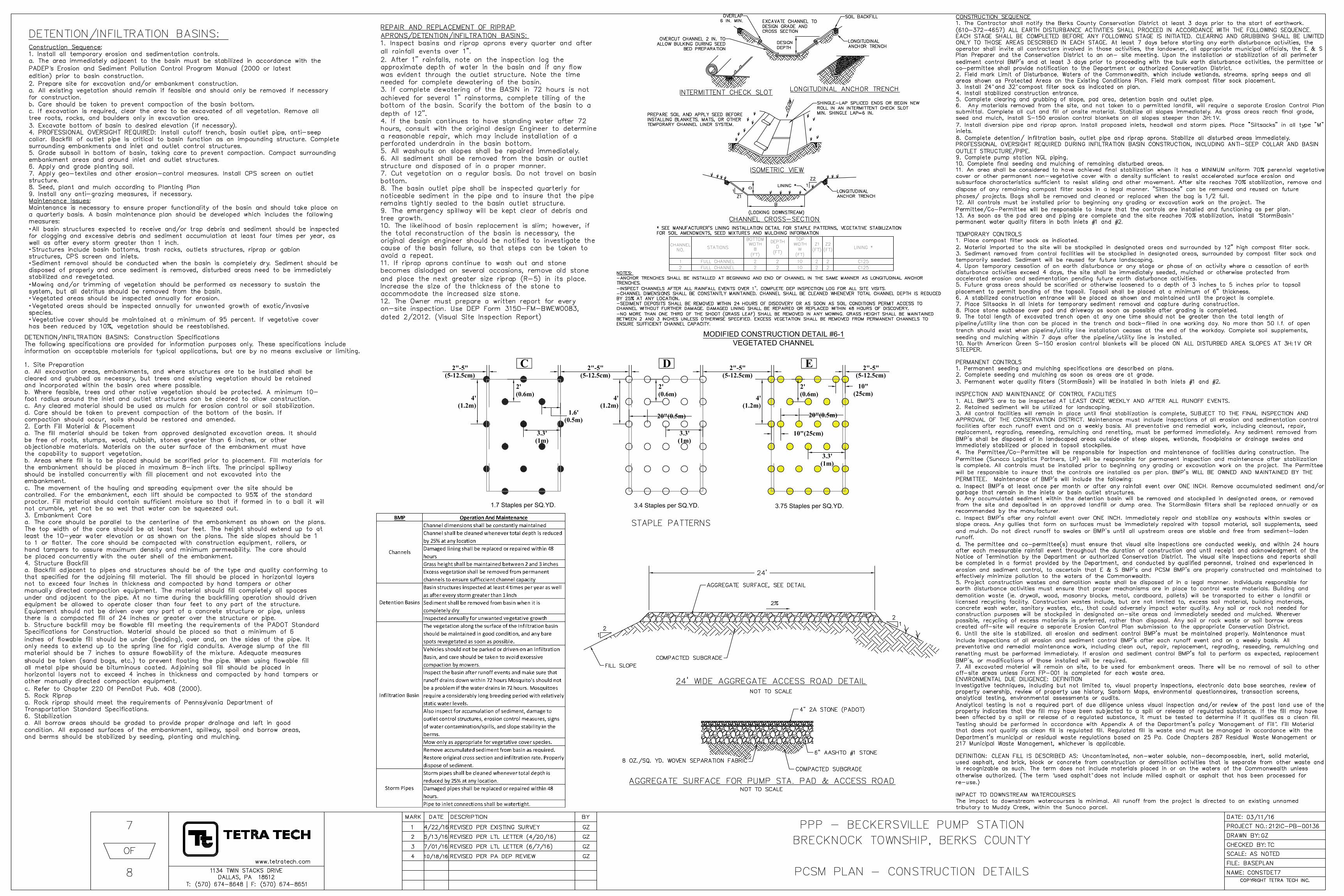
1.7 Staples per SQ.YD.3.4 Staples per SQ.YD.
3.75 Staples per SQ.YD.
C D E2"-5"(5-12.5cm)
2"-5"(5-12.5cm)
2"-5"(5-12.5cm)
2"-5"(5-12.5cm)
3.3'(1m)
3.3'(1m)
3.3'(1m)
1.6'(0.5m)
4'(1.2m)
4'(1.2m)
2'(0.6m)
2'(0.6m)
20"(0.5m)
MODIFIED CONSTRUCTION DETAIL #6-1
VEGETATED CHANNEL
” ”
“ ”
“ ”
“ ”
AutoCAD SHX Text
MARK
AutoCAD SHX Text
DATE
AutoCAD SHX Text
DESCRIPTION
AutoCAD SHX Text
BY
AutoCAD SHX Text
SCALE:
AutoCAD SHX Text
CHECKED BY:
AutoCAD SHX Text
PROJECT NO.:
AutoCAD SHX Text
DRAWN BY:
AutoCAD SHX Text
www.tetratech.com
AutoCAD SHX Text
1134 TWIN STACKS DRIVE DALLAS, PA 18612 T: (570) 674-8648 | F: (570) 674-8651
AutoCAD SHX Text
NAME:
AutoCAD SHX Text
DATE:
AutoCAD SHX Text
COPYRIGHT TETRA TECH INC.
AutoCAD SHX Text
FILE:
AutoCAD SHX Text
OF
AutoCAD SHX Text
03/11/16
AutoCAD SHX Text
212IC-PB-00136
AutoCAD SHX Text
GZ
AutoCAD SHX Text
TC
AutoCAD SHX Text
AS NOTED
AutoCAD SHX Text
BASEPLAN
AutoCAD SHX Text
CONSTDET7
AutoCAD SHX Text
PPP - BECKERSVILLE PUMP STATION
AutoCAD SHX Text
BRECKNOCK TOWNSHIP, BERKS COUNTY
AutoCAD SHX Text
PCSM PLAN - CONSTRUCTION DETAILS
AutoCAD SHX Text
7
AutoCAD SHX Text
8
AutoCAD SHX Text
2
AutoCAD SHX Text
5/13/16
AutoCAD SHX Text
REVISED PER LTL LETTER (4/20/16)
AutoCAD SHX Text
GZ
AutoCAD SHX Text
1
AutoCAD SHX Text
4/22/16
AutoCAD SHX Text
REVISED PER EXISTING SURVEY
AutoCAD SHX Text
GZ
AutoCAD SHX Text
3
AutoCAD SHX Text
7/01/16
AutoCAD SHX Text
REVISED PER LTL LETTER (6/7/16)
AutoCAD SHX Text
GZ
AutoCAD SHX Text
4
AutoCAD SHX Text
10/18/16
AutoCAD SHX Text
REVISED PER PA DEP REVIEW
AutoCAD SHX Text
GZ
AutoCAD SHX Text
AGGREGATE SURFACE FOR PUMP STA. PAD & ACCESS ROAD NOT TO SCALE
AutoCAD SHX Text
FILL SLOPE
AutoCAD SHX Text
COMPACTED SUBGRADE
AutoCAD SHX Text
AGGREGATE SURFACE, SEE DETAIL
AutoCAD SHX Text
1
AutoCAD SHX Text
2
AutoCAD SHX Text
2%
AutoCAD SHX Text
4" 2A STONE (PADOT)
AutoCAD SHX Text
6" AASHTO #1 STONE
AutoCAD SHX Text
COMPACTED SUBGRADE
AutoCAD SHX Text
24' WIDE AGGREGATE ACCESS ROAD DETAIL NOT TO SCALE
AutoCAD SHX Text
8 OZ./SQ. YD. WOVEN SEPARATION FABRIC
AutoCAD SHX Text
1
AutoCAD SHX Text
2
AutoCAD SHX Text
Construction Sequence: : 1. Install all temporary erosion and sedimentation controls. a. The area immediately adjacent to the basin must be stabilized in accordance with the PADEP’s Erosion and Sediment Pollution Control Program Manual (2000 or latest s Erosion and Sediment Pollution Control Program Manual (2000 or latest edition) prior to basin construction. 2. Prepare site for excavation and/or embankment construction. a. All existing vegetation should remain if feasible and should only be removed if necessary for construction. b. Care should be taken to prevent compaction of the basin bottom. c. If excavation is required, clear the area to be excavated of all vegetation. Remove all tree roots, rocks, and boulders only in excavation area. 3. Excavate bottom of basin to desired elevation (if necessary). 4. PROFESSIONAL OVERSIGHT REQUIRED: Install cutoff trench, basin outlet pipe, anti-seep collar. Backfill of outlet pipe is critical to basin function as an impounding structure. Complete surrounding embankments and inlet and outlet control structures. 5. Grade subsoil in bottom of basin, taking care to prevent compaction. Compact surrounding embankment areas and around inlet and outlet structures. 6. Apply and grade planting soil. 7. Apply geo-textiles and other erosion-control measures. Install CPS screen on outlet structure. 8. Seed, plant and mulch according to Planting Plan 9. Install any anti-grazing measures, if necessary. Maintenance Issues: : Maintenance is necessary to ensure proper functionality of the basin and should take place on a quarterly basis. A basin maintenance plan should be developed which includes the following measures: All basin structures expected to receive and/or trap debris and sediment should be inspected for clogging and excessive debris and sediment accumulation at least four times per year, as well as after every storm greater than 1 inch. Structures include basin bottoms, trash racks, outlets structures, riprap or gabion structures, CPS screen and inlets. Sediment removal should be conducted when the basin is completely dry. Sediment should be disposed of properly and once sediment is removed, disturbed areas need to be immediately stabilized and revegetated. Mowing and/or trimming of vegetation should be performed as necessary to sustain the system, but all detritus should be removed from the basin. Vegetated areas should be inspected annually for erosion. Vegetated areas should be inspected annually for unwanted growth of exotic/invasive species. Vegetative cover should be maintained at a minimum of 95 percent. If vegetative cover has been reduced by 10%, vegetation should be reestablished.
AutoCAD SHX Text
DETENTION/INFILTRATION BASINS: Construction Specifications The following specifications are provided for information purposes only. These specifications include information on acceptable materials for typical applications, but are by no means exclusive or limiting. 1. Site Preparation a. All excavation areas, embankments, and where structures are to be installed shall be cleared and grubbed as necessary, but trees and existing vegetation should be retained and incorporated within the basin area where possible. b. Where feasible, trees and other native vegetation should be protected. A minimum 10- foot radius around the inlet and outlet structures can be cleared to allow construction. c. Any cleared material should be used as mulch for erosion control or soil stabilization. d. Care should be taken to prevent compaction of the bottom of the basin. If compaction should occur, soils should be restored and amended. 2. Earth Fill Material & Placement a. The fill material should be taken from approved designated excavation areas. It should be free of roots, stumps, wood, rubbish, stones greater than 6 inches, or other objectionable materials. Materials on the outer surface of the embankment must have the capability to support vegetation. b. Areas where fill is to be placed should be scarified prior to placement. Fill materials for the embankment should be placed in maximum 8-inch lifts. The principal spillway should be installed concurrently with fill placement and not excavated into the embankment. c. The movement of the hauling and spreading equipment over the site should be controlled. For the embankment, each lift should be compacted to 95% of the standard proctor. Fill material should contain sufficient moisture so that if formed in to a ball it will not crumble, yet not be so wet that water can be squeezed out. 3. Embankment Core a. The core should be parallel to the centerline of the embankment as shown on the plans. The top width of the core should be at least four feet. The height should extend up to at least the 10-year water elevation or as shown on the plans. The side slopes should be 1 to 1 or flatter. The core should be compacted with construction equipment, rollers, or hand tampers to assure maximum density and minimum permeability. The core should be placed concurrently with the outer shell of the embankment. 4. Structure Backfill a. Backfill adjacent to pipes and structures should be of the type and quality conforming to that specified for the adjoining fill material. The fill should be placed in horizontal layers not to exceed four inches in thickness and compacted by hand tampers or other manually directed compaction equipment. The material should fill completely all spaces under and adjacent to the pipe. At no time during the backfilling operation should driven equipment be allowed to operate closer than four feet to any part of the structure. Equipment should not be driven over any part of a concrete structure or pipe, unless there is a compacted fill of 24 inches or greater over the structure or pipe. b. Structure backfill may be flowable fill meeting the requirements of the PADOT Standard Specifications for Construction. Material should be placed so that a minimum of 6 inches of flowable fill should be under (bedding), over and, on the sides of the pipe. It only needs to extend up to the spring line for rigid conduits. Average slump of the fill material should be 7 inches to assure flowability of the mixture. Adequate measures should be taken (sand bags, etc.) to prevent floating the pipe. When using flowable fill all metal pipe should be bituminous coated. Adjoining soil fill should be placed in horizontal layers not to exceed 4 inches in thickness and compacted by hand tampers or other manually directed compaction equipment. c. Refer to Chapter 220 0f PennDot Pub. 408 (2000). 5. Rock Riprap a. Rock riprap should meet the requirements of Pennsylvania Department of Transportation Standard Specifications. 6. Stabilization a. All borrow areas should be graded to provide proper drainage and left in good condition. All exposed surfaces of the embankment, spillway, spoil and borrow areas, and berms should be stabilized by seeding, planting and mulching.
AutoCAD SHX Text
REPAIR AND REPLACEMENT OF RIPRAP APRONS/DETENTION/INFILTRATION BASINS: 1. Inspect basins and riprap aprons every quarter and after all rainfall events over 1". 2. After 1" rainfalls, note on the inspection log the approximate depth of water in the basin and if any flow was evident through the outlet structure. Note the time needed for complete dewatering of the basin. 3. If complete dewatering of the BASIN in 72 hours is not achieved for several 1" rainstorms, complete tilling of the bottom of the basin. Scarify the bottom of the basin to a depth of 12". 4. If the basin continues to have standing water after 72 hours, consult with the original design Engineer to determine a reasonable repair, which may include installation of a perforated underdrain in the basin bottom. 5. All washouts on slopes shall be repaired immediately. 6. All sediment shall be removed from the basin or outlet structure and disposed of in a proper manner. 7. Cut vegetation on a regular basis. Do not travel on basin bottom. 8. The basin outlet pipe shall be inspected quarterly for noticeable sediment in the pipe and to insure that the pipe remains tightly sealed to the basin outlet structure. 9. The emergency spillway will be kept clear of debris and tree growth. 10. The likelihood of basin replacement is slim; however, if the total reconstruction of the basin is necessary, the original design engineer should be notified to investigate the cause of the basin failure, so that steps can be taken to avoid a repeat. 11. If riprap aprons continue to wash out and stone becomes dislodged on several occasions, remove old stone and place the next greater size riprap (R-5) in its place. Increase the size of the thickness of the stone to accommodate the increased size stone. 12. The Owner must prepare a written report for every on-site inspection. Use DEP Form 3150-FM-BWEW0083, dated 2/2012. (Visual Site Inspection Report)
AutoCAD SHX Text
DETENTION/INFILTRATION BASINS:
AutoCAD SHX Text
STAPLE PATTERNS
AutoCAD SHX Text
SOIL BACKFILL
AutoCAD SHX Text
LONGITUDINAL ANCHOR TRENCH
AutoCAD SHX Text
OVERLAP 6 IN. MIN.
AutoCAD SHX Text
OVERCUT CHANNEL 2 IN. TO ALLOW BULKING DURING SEED BED PREPARATION
AutoCAD SHX Text
EXCAVATE CHANNEL TO DESIGN GRADE AND CROSS SECTION
AutoCAD SHX Text
DESIGN DEPTH
AutoCAD SHX Text
PREPARE SOIL AND APPLY SEED BEFORE INSTALLING BLANKETS, MATS, OR OTHER TEMPORARY CHANNEL LINER SYSTEM.
AutoCAD SHX Text
SHINGLE-LAP SPLICED ENDS OR BEGIN NEW ROLL IN AN INTERMITTENT CHECK SLOT MIN. SHINGLE LAP=6 IN.
AutoCAD SHX Text
FLOW
AutoCAD SHX Text
Z2
AutoCAD SHX Text
1
AutoCAD SHX Text
Z1
AutoCAD SHX Text
1
AutoCAD SHX Text
LINING *
AutoCAD SHX Text
* SEE MANUFACTURER'S LINING INSTALLATION DETAIL FOR STAPLE PATTERNS, VEGETATIVE STABILIZATION FOR SOIL AMENDMENTS, SEED MIXTURES AND MULCHING INFORMATION
AutoCAD SHX Text
LONGITUDINAL ANCHOR TRENCH
AutoCAD SHX Text
(LOOKING DOWNSTREAM)
AutoCAD SHX Text
ISOMETRIC VIEW
AutoCAD SHX Text
CHANNEL CROSS-SECTION
AutoCAD SHX Text
INTERMITTENT CHECK SLOT
AutoCAD SHX Text
LONGITUDINAL ANCHOR TRENCH
AutoCAD SHX Text
NOTES: -ANCHOR TRENCHES SHALL BE INSTALLED AT BEGINNING AND END OF CHANNEL IN THE SAME MANNER AS LONGITUDINAL ANCHOR TRENCHES. -INSPECT CHANNELS AFTER ALL RAINFALL EVENTS OVER 1". COMPLETE DEP INSPECTION LOG FOR ALL SITE VISITS. -CHANNEL DIMENSIONS SHALL BE CONSTANTLY MAINTAINED. CHANNEL SHALL BE CLEANED WHENEVER TOTAL CHANNEL DEPTH IS REDUCED BY 25% AT ANY LOCATION. -SEDIMENT DEPOSITS SHALL BE REMOVED WITHIN 24 HOURS OF DISCOVERY OR AS SOON AS SOIL CONDITIONS PERMIT ACCESS TO CHANNEL WITHOUT FURTHER DAMAGE. DAMAGED LINING SHALL BE REPAIRED OR REPLACED WITHIN 48 HOURS OF DISCOVERY. -NO MORE THAN ONE THIRD OF THE SHOOT (GRASS LEAF) SHALL BE REMOVED IN ANY MOWING. GRASS HEIGHT SHALL BE MAINTAINED BETWEEN 2 AND 3 INCHES UNLESS OTHERWISE SPECIFIED. EXCESS VEGETATION SHALL BE REMOVED FROM PERMANENT CHANNELS TO ENSURE SUFFICIENT CHANNEL CAPACITY.
AutoCAD SHX Text
CHANNEL NO.
AutoCAD SHX Text
STATIONS
AutoCAD SHX Text
BOTTOM WIDTH B (FT)
AutoCAD SHX Text
DEPTH D (FT)
AutoCAD SHX Text
TOP WIDTH W (FT)
AutoCAD SHX Text
Z1 (FT)
AutoCAD SHX Text
Z2 (FT)
AutoCAD SHX Text
LINING *
AutoCAD SHX Text
1
AutoCAD SHX Text
FULL CHANNEL
AutoCAD SHX Text
2
AutoCAD SHX Text
2
AutoCAD SHX Text
10
AutoCAD SHX Text
2
AutoCAD SHX Text
2
AutoCAD SHX Text
C125
AutoCAD SHX Text
2
AutoCAD SHX Text
FULL CHANNEL
AutoCAD SHX Text
2
AutoCAD SHX Text
2
AutoCAD SHX Text
10
AutoCAD SHX Text
2
AutoCAD SHX Text
2
AutoCAD SHX Text
C125
AutoCAD SHX Text
CONSTRUCTION SEQUENCE 1. The Contractor shall notify the Berks County Conservation District at least 3 days prior to the start of earthwork. (610-372-4657) ALL EARTH DISTURBANCE ACTIVITIES SHALL PROCEED IN ACCORDANCE WITH THE FOLLOWING SEQUENCE. EACH STAGE SHALL BE COMPLETED BEFORE ANY FOLLOWING STAGE IS INITIATED. CLEARING AND GRUBBING SHALL BE LIMITED ONLY TO THOSE AREAS DESCRIBED IN EACH STAGE. At least 7 days before starting any earth disturbance activities, the operator shall invite all contractors involved in those activities, the landowner, all appropriate municipal officials, the E & S Plan Preparer and the Conservation District to an on- site meeting. Upon the installation or stabilization of all perimeter sediment control BMP's and at least 3 days prior to proceeding with the bulk earth disturbance activities, the permittee or co-permittee shall provide notification to the Department or authorized Conservation District. 2. Field mark Limit of Disturbance, Waters of the Commonwealth, which include wetlands, streams, spring seeps and all areas shown as Protected Areas on the Existing Conditions Plan. Field mark compost filter sock placement. 3. Install 24” and 32” compost filter sock as indicated on plan. and 32” compost filter sock as indicated on plan. compost filter sock as indicated on plan. 4. Install stabilized construction entrance. 5. Complete clearing and grubbing of slope, pad area, detention basin and outlet pipe. 6. Any materials removed from the site, and not taken to a permitted landfill, will require a separate Erosion Control Plan submittal. Complete all cut and fill of onsite material. Stabilize all slopes immediately. As grass areas reach final grade, seed and mulch, install S-150 erosion control blankets on all slopes steeper than 3H:1V. 7. Install diversion pipe and riprap apron. Install proposed inlets, headwall and storm pipes. Place "Siltsacks" in all type "M" inlets. 8. Complete detention/ infiltration basin, outlet pipe and riprap aprons. Stabilize all disturbed areas immediately. PROFESSIONAL OVERSIGHT REQUIRED DURING INFILTRATION BASIN CONSTRUCTION, INCLUDING ANTI-SEEP COLLAR AND BASIN OUTLET STRUCTURE/PIPE. 9. Complete pump station NGL piping. 10. Complete final seeding and mulching of remaining disturbed areas. 11. An area shall be considered to have achieved final stabilization when it has a MINIMUM uniform 70% perennial vegetative cover or other permanent non-vegetative cover with a density sufficient to resist accelerated surface erosion and subsurface characteristics sufficient to resist sliding and other movement. After site reaches 70% stabilization, remove and dispose of any remaining compost filter socks in a legal manner. "Siltsacks" can be removed and reused on future phases/ projects. Bags shall be removed and cleaned or replaced when the bag is 1/2 full. 12. All controls must be installed prior to beginning any grading or excavation work on the project. The Permittee/Co-Permittee will be responsible to insure that the controls are installed and functioning as per plan. 13. As soon as the pad area and piping are complete and the site reaches 70% stabilization, install “StormBasin” StormBasin” permanent water quality filters in both inlets #1 and #2. TEMPORARY CONTROLS 1. Place compost filter sock as indicated. 2. Material imported to the site will be stockpiled in designated areas and surrounded by 12" high compost filter sock. 3. Sediment removed from control facilities will be stockpiled in designated areas, surrounded by compost filter sock and temporarily seeded. Sediment will be reused for future landscaping. 4. Upon temporary cessation of an earth disturbance or any stage or phase of an activity where a cessation of earth disturbance activities exceed 4 days, the site shall be immediately seeded, mulched or otherwise protected from accelerated erosion and sedimentation pending future earth disturbance activities. 5. Future grass areas should be scarified or otherwise loosened to a depth of 3 inches to 5 inches prior to topsoil placement to permit bonding of the topsoil. Topsoil shall be placed at a minimum of 6" thickness. 6. A stabilized construction entrance will be placed as shown and maintained until the project is complete. 7. Place Siltsacks in all inlets for temporary sediment removal and capture during construction. 8. Place stone subbase over pad and driveway as soon as possible after grading is completed. 9. The total length of excavated trench open at any one time should not be greater than the total length of pipeline/utility line than can be placed in the trench and back-filled in one working day. No more than 50 l.f. of open trench should exist when pipeline/utility line installation ceases at the end of the workday. Complete soil supplements, seeding and mulching within 7 days after the pipeline/utility line is installed. 10. North American Green S-150 erosion control blankets will be placed ON ALL DISTURBED AREA SLOPES AT 3H:1V OR STEEPER. PERMANENT CONTROLS 1. Permanent seeding and mulching specifications are described on plans. 2. Complete seeding and mulching as soon as areas are at grade. 3. Permanent water quality filters (StormBasin) will be installed in both inlets #1 and #2. INSPECTION AND MAINTENANCE OF CONTROL FACILITIES 1. ALL BMP'S are to be inspected AT LEAST ONCE WEEKLY AND AFTER ALL RUNOFF EVENTS. 2. Retained sediment will be utilized for landscaping. 3. All control facilities will remain in place until final stabilization is complete, SUBJECT TO THE FINAL INSPECTION AND APPROVAL OF THE CONSERVATION DISTRICT. Maintenance must include inspections of all erosion and sedimentation control facilities after each runoff event and on a weekly basis. All preventative and remedial work, including cleanout, repair, replacement, regrading, reseeding, remulching and renetting, must be performed immediately. Any sediment removed from BMP's shall be disposed of in landscaped areas outside of steep slopes, wetlands, floodplains or drainage swales and immediately stabilized or placed in topsoil stockpiles. 4. The Permittee/Co-Permittee will be responsible for inspection and maintenance of facilities during construction. The Permittee (Sunoco Logistics Partners, LP) will be responsible for permanent inspection and maintenance after stabilization is complete. All controls must be installed prior to beginning any grading or excavation work on the project. The Permittee will be responsible to insure that the controls are installed as per plan. BMP's WILL BE OWNED AND MAINTAINED BY THE PERMITTEE. Maintenance of BMP's will include the following: a. Inspect BMP's at least once per month or after any rainfall event over ONE INCH. Remove accumulated sediment and/or garbage that remain in the inlets or basin outlet structures. b. Any accumulated sediment within the detention basin will be removed and stockpiled in designated areas, or removed from the site and deposited in an approved landfill or dump area. The StormBasin filters shall be replaced annually or as recommended by the manufacturer. c. Inspect BMP's after any rainfall event over ONE INCH. Immediately repair and stabilize any washouts within swales or slope areas. Any gullies that form on surfaces must be immediately repaired with topsoil material, soil supplements, seed and mulch. Do not direct runoff to swales or BMP's until all upstream areas are stable and free from sediment-laden runoff. d. The permittee and co-permittee(s) must ensure that visual site inspections are conducted weekly, and within 24 hours after each measurable rainfall event throughout the duration of construction and until receipt and acknowledgment of the Notice of Termination by the Department or authorized Conservation District. The visual site inspections and reports shall be completed in a format provided by the Department, and conducted by qualified personnel, trained and experienced in erosion and sediment control, to ascertain that E & S BMP's and PCSM BMP's are properly constructed and maintained to effectively minimize pollution to the waters of the Commonwealth. 5. Project construction wastes and demolition waste shall be disposed of in a legal manner. Individuals responsible for earth disturbance activities must ensure that proper mechanisms are in place to control waste materials. Building and demolition waste (ie. drywall, wood, masonry blocks, metal, cardboard, pallets) will be transported to either a landfill or licensed recycling facility. Construction wastes include, but are not limited to, excess soil material, building materials, concrete wash water, sanitary wastes, etc., that could adversely impact water quality. Any soil or rock not needed for construction purposes will be stockpiled in designated on-site areas and immediately seeded and mulched. Wherever possible, recycling of excess materials is preferred, rather than disposal. Any soil or rock waste or soil borrow areas created off-site will require a separate Erosion Control Plan submission to the appropriate Conservation District. 6. Until the site is stabilized, all erosion and sediment control BMP's must be maintained properly. Maintenance must include inspections of all erosion and sediment control BMP's after each runoff event and on a weekly basis. All preventative and remedial maintenance work, including clean out, repair, replacement, regrading, reseeding, remulching and renetting must be performed immediately. If erosion and sediment control BMP's fail to perform as expected, replacement BMP's, or modifications of those installed will be required. 7. All excavated material will remain on site, to be used for embankment areas. There will be no removal of soil to other off-site areas unless Form FP-001 is completed for each waste area. ENVIRONMENTAL DUE DILIGENCE: DEFINITION Investigative techniques, including but not limited to, visual property inspections, electronic data base searches, review of property ownership, review of property use history, Sanborn Maps, environmental questionnaires, transaction screens, analytical testing, environmental assessments or audits. Analytical testing is not a required part of due diligence unless visual inspection and/or review of the past land use of the property indicates that the fill may have been subjected to a spill or release of regulated substance. If the fill may have been affected by a spill or release of a regulated substance, it must be tested to determine if it qualifies as a clean fill. Testing should be performed in accordance with Appendix A of the Department's policy “Management of Fill”. Fill Material Management of Fill”. Fill Material . Fill Material that does not qualify as clean fill is regulated fill. Regulated fill is waste and must be managed in accordance with the Department's municipal or residual waste regulations based on 25 Pa. Code Chapters 287 Residual Waste Management or 217 Municipal Waste Management, whichever is applicable. DEFINITION: CLEAN FILL IS DESCRIBED AS: Uncontaminated, non-water soluble, non-decomposable, inert, solid material, used asphalt, and brick, block or concrete from construction or demolition activities that is separate from other waste and is recognizable as such. The term does not include materials placed in or on the waters of the Commonwealth unless otherwise authorized. (The term “used asphalt” does not include milled asphalt or asphalt that has been processed for used asphalt” does not include milled asphalt or asphalt that has been processed for does not include milled asphalt or asphalt that has been processed for re-use.) IMPACT TO DOWNSTREAM WATERCOURSES The impact to downstream watercourses is minimal. All runoff from the project is directed to an existing unnamed tributary to Muddy Creek, within the Sunoco parcel.

AutoCAD SHX Text
MARK
AutoCAD SHX Text
DATE
AutoCAD SHX Text
DESCRIPTION
AutoCAD SHX Text
BY
AutoCAD SHX Text
SCALE:
AutoCAD SHX Text
CHECKED BY:
AutoCAD SHX Text
PROJECT NO.:
AutoCAD SHX Text
DRAWN BY:
AutoCAD SHX Text
www.tetratech.com
AutoCAD SHX Text
1134 TWIN STACKS DRIVE DALLAS, PA 18612 T: (570) 674-8648 | F: (570) 674-8651
AutoCAD SHX Text
NAME:
AutoCAD SHX Text
DATE:
AutoCAD SHX Text
COPYRIGHT TETRA TECH INC.
AutoCAD SHX Text
FILE:
AutoCAD SHX Text
OF
AutoCAD SHX Text
03/11/16
AutoCAD SHX Text
212IC-PB-00136
AutoCAD SHX Text
GZ
AutoCAD SHX Text
TC
AutoCAD SHX Text
AS NOTED
AutoCAD SHX Text
BASEPLAN
AutoCAD SHX Text
CONSTDET8
AutoCAD SHX Text
PPP - BECKERSVILLE PUMP STATION
AutoCAD SHX Text
BRECKNOCK TOWNSHIP, BERKS COUNTY
AutoCAD SHX Text
PCSM PLAN - CONSTRUCTION DETAILS
AutoCAD SHX Text
8
AutoCAD SHX Text
8
AutoCAD SHX Text
PROVIDE MODEL 9730-2X STORMBASIN FILTERS AS MANUFACTURED BY FABCO, OR APPROVED EQUAL. PLACE FILTERS IN BOTH INLETS #1 AND #2.
AutoCAD SHX Text
2
AutoCAD SHX Text
5/13/16
AutoCAD SHX Text
REVISED PER LTL LETTER (4/20/16)
AutoCAD SHX Text
GZ
AutoCAD SHX Text
1
AutoCAD SHX Text
4/22/16
AutoCAD SHX Text
REVISED PER EXISTING SURVEY
AutoCAD SHX Text
GZ
AutoCAD SHX Text
3
AutoCAD SHX Text
7/01/16
AutoCAD SHX Text
REVISED PER LTL LETTER (6/7/16)
AutoCAD SHX Text
GZ
AutoCAD SHX Text
4
AutoCAD SHX Text
10/18/16
AutoCAD SHX Text
REVISED PER PA DEP REVIEW
AutoCAD SHX Text
GZ