Pedestrian planning and design guide. chapter 4 community ...
6
The principles of pedestrian network planning 4-1 4 COMMUNITY WALKABILITY COMMUNITY WALKABILITY Making communities walkable Urban form Feeling secure 4.2 Aspects of walkable communities Getting there – on foot, by cycle, the national strategy for walking and cycling, states in its key principles that: ‘Individuals are more likely to choose to walk or cycle if they see the environment as being walk-and-cycle-friendly – that is, convenient, safe and pleasant, with direct routes that minimise travel time. ‘A comprehensive approach that works to maximise the range of destinations within walking or cycling distance, to improve the environment for walking and cycling, and to show individuals how these modes can effectively meet their personal needs will have the best chance of success.’ It takes several important qualities to describe a walkable community. Many ways are used to classify these, but all attempt to describe the same characteristics. The nine primary characteristics shown in Table 4.1 are considered to provide a convenient description of a truly walkable community. Three interrelated areas – land use planning, pedestrian infrastructure and the road controlling authority’s (RCA) attitude [19] – have a significant impact on walkability. Appendix 2 has more details on pedestrian issues to address in district plans. Table 4.2 summarises the policies affecting walkable communities. Table 4.1 – Primary characteristics of walkable communities Characteristic Definition Connected Does the network provide direct access for pedestrians to the places they wish to reach? Do paths connect well to public transport and to surrounding networks? Legible Are walking networks clearly signposted and are they published in local maps? Can visitors find their way? Do users intuitively sense how to use the facilities? Comfortable Are routes unpolluted by excessive noise and fumes? Are paths wide enough with even surfaces and gentle gradients? Is there shelter from the elements and places to rest? Convenient Are routes continuous, efficient, unimpeded by obstacles, and undelayed by other path users and road traffic? Pleasant Are the pedestrian spaces enjoyable, interesting, quiet and clean with qualities encouraging lingering and social interaction? Safe Are road crossing places and driveway crossings safe from traffic danger and do all surfaces provide a good grip when wet and provide even surfaces free from trip hazards? Secure Does the walking environment discourage antisocial and criminal behaviour due to the application of the principles of crime prevention through environmental design? Universal Are facilities suitable for mobility and vision-impaired pedestrians through gentle gradients, visual contrast, audible and tactile features? Accessible Are popular destinations within easy walking distance. 4.1 Introduction ‘Walkability’ describes the extent to which the built environment is walking-friendly. It is a useful way to assess the characteristics of an area or a route, although it can be subjective. Section 11 discusses methods for assessing walkability.
Transcript of Pedestrian planning and design guide. chapter 4 community ...

The principles of pedestrian network planning 4-1
4 cOMMUNITy WALkABILITyCoMMunITy WALKABILITy
Making communities walkable
Urban form
feeling secure
4.2 Aspects of walkable communitiesGetting there – on foot, by cycle, the national strategy for walking and cycling, states in its key principles that:
‘Individuals are more likely to choose to walk or cycle if they see the environment as being walk-and-cycle-friendly – that is, convenient, safe and pleasant, with direct routes that minimise travel time.
‘A comprehensive approach that works to maximise the range of destinations within walking or cycling distance, to improve the environment for walking and cycling, and to show individuals how these modes can effectively meet their personal needs will have the best chance of success.’
It takes several important qualities to describe a walkable community. Many ways are used to classify these, but all attempt to describe the same characteristics. The nine primary characteristics shown in Table 4.1 are considered to provide a convenient description of a truly walkable community.
Three interrelated areas – land use planning, pedestrian infrastructure and the road controlling authority’s (RcA) attitude [19] – have a significant impact on walkability. Appendix 2 has more details on pedestrian issues to address in district plans. Table 4.2 summarises the policies affecting walkable communities.
Table 4.1 – Primary characteristics of walkable communities
Characteristic definition
Connected does the network provide direct access for pedestrians to the places they wish to reach? do paths connect well to public transport and to surrounding networks?
Legible Are walking networks clearly signposted and are they published in local maps? Can visitors find their way? do users intuitively sense how to use the facilities?
Comfortable Are routes unpolluted by excessive noise and fumes? Are paths wide enough with even surfaces and gentle gradients? Is there shelter from the elements and places to rest?
Convenient Are routes continuous, efficient, unimpeded by obstacles, and undelayed by other path users and road traffic?
Pleasant Are the pedestrian spaces enjoyable, interesting, quiet and clean with qualities encouraging lingering and social interaction?
Safe Are road crossing places and driveway crossings safe from traffic danger and do all surfaces provide a good grip when wet and provide even surfaces free from trip hazards?
Secure does the walking environment discourage antisocial and criminal behaviour due to the application of the principles of crime prevention through environmental design?
universal Are facilities suitable for mobility and vision-impaired pedestrians through gentle gradients, visual contrast, audible and tactile features?
Accessible Are popular destinations within easy walking distance.
4.1 Introduction‘Walkability’ describes the extent to which the built environment is walking-friendly. It is a useful way to assess the characteristics of an area or a route, although it can be subjective. Section 11 discusses methods for assessing walkability.
The principles of pedestrian network planning4-2
4.3 The importance of urban form‘Urban form’ relates to how settlements are designed and structured, the type of development that is allowed and where, and how the different areas are connected. Urban form affects the need to travel [63, 106, 163] and the attractiveness (or otherwise) of walking as a practical form of transport [26, 63, 64, 106, 172].
Three interrelated elements affect whether urban form is suitable for pedestrians – pedestrian permeability, connections to transport and strategic planning [5, 103] (see Table 4.3).
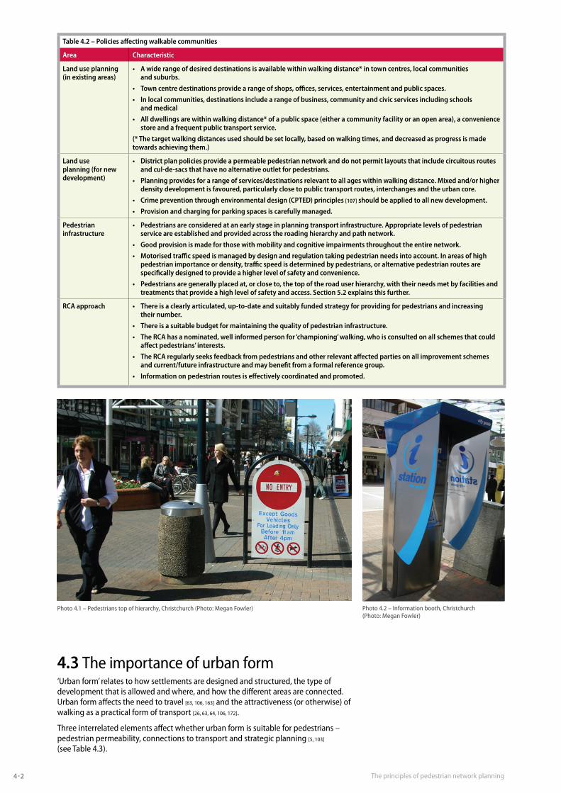
Table 4.2 – Policies affecting walkable communities
Area Characteristic
Land use planning (in existing areas)
• Awiderangeofdesireddestinationsisavailablewithinwalkingdistance*intowncentres,localcommunities and suburbs.
• Towncentredestinationsprovidearangeofshops,offices,services,entertainmentandpublicspaces.
• Inlocalcommunities,destinationsincludearangeofbusiness,communityandcivicservicesincludingschools and medical
• Alldwellingsarewithinwalkingdistance*ofapublicspace(eitheracommunityfacilityoranopenarea),aconveniencestore and a frequent public transport service.
(* The target walking distances used should be set locally, based on walking times, and decreased as progress is made towards achieving them.)
Land use planning (for new development)
• Districtplanpoliciesprovideapermeablepedestriannetworkanddonotpermitlayoutsthatincludecircuitousroutesand cul-de-sacs that have no alternative outlet for pedestrians.
• Planningprovidesforarangeofservices/destinationsrelevanttoallageswithinwalkingdistance.Mixedand/orhigherdensity development is favoured, particularly close to public transport routes, interchanges and the urban core.
• Crimepreventionthroughenvironmentaldesign(CPTED)principles[107] should be applied to all new development.
• Provisionandchargingforparkingspacesiscarefullymanaged.
Pedestrian infrastructure
• Pedestriansareconsideredatanearlystageinplanningtransportinfrastructure.Appropriatelevelsofpedestrianservice are established and provided across the roading hierarchy and path network.
• Goodprovisionismadeforthosewithmobilityandcognitiveimpairmentsthroughouttheentirenetwork.
• Motorisedtrafficspeedismanagedbydesignandregulationtakingpedestrianneedsintoaccount.Inareasofhighpedestrian importance or density, traffic speed is determined by pedestrians, or alternative pedestrian routes are specifically designed to provide a higher level of safety and convenience.
• Pedestriansaregenerallyplacedat,orcloseto,thetopoftheroaduserhierarchy,withtheirneedsmetbyfacilitiesandtreatments that provide a high level of safety and access. Section 5.2 explains this further.
RCA approach • Thereisaclearlyarticulated,up-to-dateandsuitablyfundedstrategyforprovidingforpedestriansandincreasing their number.
• Thereisasuitablebudgetformaintainingthequalityofpedestrianinfrastructure.
• TheRCAhasanominated,wellinformedpersonfor‘championing’walking,whoisconsultedonallschemesthatcouldaffect pedestrians’ interests.
• TheRCAregularlyseeksfeedbackfrompedestriansandotherrelevantaffectedpartiesonallimprovementschemesand current/future infrastructure and may benefit from a formal reference group.
• Informationonpedestrianroutesiseffectivelycoordinatedandpromoted.
Photo 4.1 – Pedestrians top of hierarchy, christchurch (Photo: Megan fowler) Photo 4.2 – Information booth, christchurch (Photo: Megan fowler)
The principles of pedestrian network planning 4-3
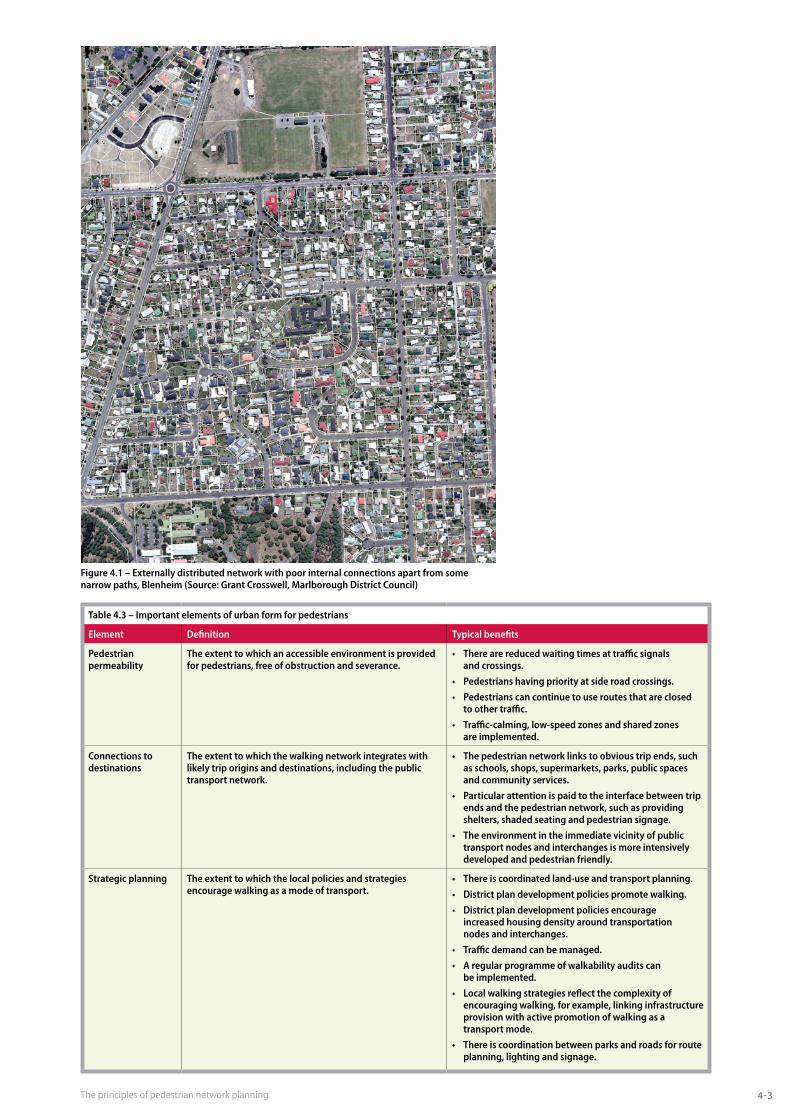
figure 4.1 – externally distributed network with poor internal connections apart from some narrow paths, Blenheim (Source: grant Crosswell, Marlborough district Council)
Table 4.3 – Important elements of urban form for pedestrians
element definition Typical benefits
Pedestrian permeability
The extent to which an accessible environment is provided for pedestrians, free of obstruction and severance.
• Therearereducedwaitingtimesattrafficsignals and crossings.
• Pedestrianshavingpriorityatsideroadcrossings.
• Pedestrianscancontinuetouseroutesthatareclosed to other traffic.
• Traffic-calming,low-speedzonesandsharedzones are implemented.
Connections to destinations
The extent to which the walking network integrates with likely trip origins and destinations, including the public transport network.
• Thepedestriannetworklinkstoobvioustripends,suchas schools, shops, supermarkets, parks, public spaces and community services.
• Particularattentionispaidtotheinterfacebetweentripends and the pedestrian network, such as providing shelters, shaded seating and pedestrian signage.
• Theenvironmentintheimmediatevicinityofpublictransport nodes and interchanges is more intensively developed and pedestrian friendly.
Strategic planning The extent to which the local policies and strategies encourage walking as a mode of transport.
• Thereiscoordinatedland-useandtransportplanning.
• Districtplandevelopmentpoliciespromotewalking.
• Districtplandevelopmentpoliciesencourage increased housing density around transportation nodes and interchanges.
• Trafficdemandcanbemanaged.
• Aregularprogrammeofwalkabilityauditscan be implemented.
• Localwalkingstrategiesreflectthecomplexityofencouraging walking, for example, linking infrastructure provision with active promotion of walking as a transport mode.
• Thereiscoordinationbetweenparksandroadsforrouteplanning, lighting and signage.

The principles of pedestrian network planning4-4
Because pedestrians are the slowest mode, any deviation in their routes will inconvenience them more than other modes. Pedestrians benefit most from finely grained permeable networks. The appropriate spacing of pedestrian network elements relative to other modes can be judged from Table 4.4.
A trend in urban design today is towards compact, ‘neo-traditional’ patterns that feature an interconnected street network with closely located employment, retail and neighbourhood centres, transport nodes and open spaces [118]. Walking is a viable travel option in these areas owing to the reduced distance between trip origins and destinations [61, 63] and because the road layout helps to reduce severance [118]. Because highly connected grid networks have a poor traffic safety record at intersections, low-speed intersection treatments such as traffic-calming roundabouts will be important. The road network does not need to be as permeable as the pedestrian network.
Off-street pedestrian networks can have a role in neo-traditional areas as they may provide pedestrians with their most enjoyable walking experiences [4]. If well placed they can also reduce the distance travelled by those on foot and alleviate the need to walk beside high-speed roads where there is an increased chance of being hit by a vehicle [118].
careful urban design can result in drivers, cyclists and pedestrians modifying their behaviour and can reduce the dominance of motorised traffic. creating a total multi-purpose space when a development is being built eliminates the need later to retrofit a road network with disconnected traffic-calming devices [163]. It becomes safer and easier for people to walk to jobs, shopping, education, leisure and services [163]. Locating high-density residential, retail and other services around public transport interchanges provides options for longer distance trips that do not require a private motor vehicle. This further contributes to enhancing the walking
Table 4.4 – Average distance travelled in one minute
Mode Average Speed distance
Walking 5.4 km/h 90 metres
Cycling 20 km/h 330 metres
Car 54 km/h 900 metres
figure 4.2 – Traditional grid network, Blenheim (Source: grant Crosswell, Marlborough district Council)

The principles of pedestrian network planning 4-5
environment, and can result in areas deliberately created with fewer cars and greater pedestrian activity [55, 159].
Since many journeys start or end at home, the location of new housing and links to existing transport routes are particularly important. Pedestrians may be given a higher priority than private cars within residential developments [43, 122].
The quality of the street scene is particularly important for pedestrians and is associated with higher walking levels [63]. Pedestrians prefer both close and distant views of features of interest, and landscaping should be provided and maintained while always ensuring personal security. Pedestrians enjoy lively and animated street scenes, so in many situations a modest flow of vehicles is generally acceptable and provides improved natural surveillance. As traffic engineering devices can be ugly, attention to attractive design is important [124].
We need to ensure that our view of a street is more than just functional. Streets and public spaces should be beautiful, engaging and inspiring. Too often they are boring, repetitive and ugly. As a general principle, it is important to promote a quality public environment where impediments to walking are only implemented when they are absolutely essential. for urban design, People – places – spaces: a design guide for urban New Zealand [105] provides guidance on urban design principles and how to create better urban design at project level. Urban design also relates to procedures discussed further in Easy steps section c2 [175] and Manual for streets [176].
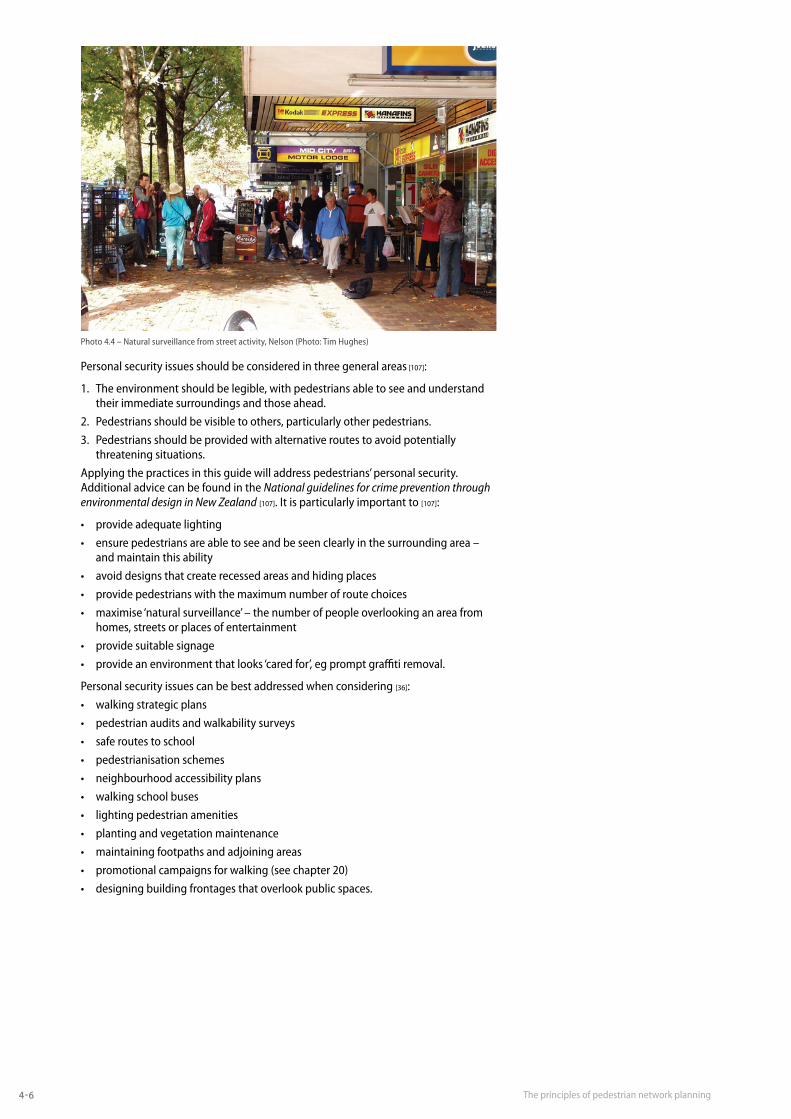
4.4 Personal security issuesPersonal security issues can be a major barrier to walking and creating walkable communities, especially during hours of darkness and in town centres [36]. People who are concerned about perceived dangers, may modify their travel behaviour by not going out alone after dark or avoiding certain areas or routes. Parents, because of perceived danger, may also modify their children’s behaviour by not allowing them to walk without adult supervision. Personal security issues can also create a barrier to accessing public transport services on foot.
Photo 4.3 – Pedestrian precinct, christchurch (Photo: Susan cambridge)
The principles of pedestrian network planning4-6
Personal security issues should be considered in three general areas [107]:
1. The environment should be legible, with pedestrians able to see and understand their immediate surroundings and those ahead.
2. Pedestrians should be visible to others, particularly other pedestrians.
3. Pedestrians should be provided with alternative routes to avoid potentially threatening situations.
Applying the practices in this guide will address pedestrians’ personal security. Additional advice can be found in the National guidelines for crime prevention through environmental design in New Zealand [107]. It is particularly important to [107]:
• provideadequatelighting
• ensure pedestrians are able to see and be seen clearly in the surrounding area – and maintain this ability
• avoid designs that create recessed areas and hiding places
• provide pedestrians with the maximum number of route choices
• maximise ‘natural surveillance’ – the number of people overlooking an area from homes, streets or places of entertainment
• provide suitable signage
• provideanenvironmentthatlooks‘caredfor’,egpromptgraffitiremoval.
Personal security issues can be best addressed when considering [36]:
• walking strategic plans
• pedestrian audits and walkability surveys
• safe routes to school
• pedestrianisation schemes
• neighbourhood accessibility plans
• walking school buses
• lighting pedestrian amenities
• planting and vegetation maintenance
• maintaining footpaths and adjoining areas
• promotional campaigns for walking (see chapter 20)
• designing building frontages that overlook public spaces.
Photo 4.4 – Natural surveillance from street activity, Nelson (Photo: Tim hughes)