Collector/Distributor -...
14
Collector/Distributor Can a collector/distributor between Vancouver in Washington State and Martin Luther King Boulevard in Oregon be of value in making the CRC better, safer and less expensive? This paper considers how a collector distributor might work and how the idea might be configured? Preface Three interchanges in the urban area and the presence of two significant river crossings force I-5 in a little over a mile ends up with an expansive array of interchange ramps, merging traffic and less than idea freeway geometric alignment. The consequence is that the freeway is big, intrusive, complicated and may suffer from safety and congestion consequences due to merging traffic conflicts and speed differences as vehicles share the same road surface for local and regional movements. This paper ever so briefly presents the possibility of a collector/distributor. As the author is not a transportation engineer or planner the ideas put forth are notional and should be considered as indicative. The intent is to present an overview of the idea to a skeptical technical and public audience that has not considered the possibility and may be subject to schedule induced pressures biasing objective consideration. This ‘eleventh hour’ consideration requires that the idea be presented in sufficient detail to ‘test’ the idea by demonstrating at least one layout that appears logical. The author has attempted to do this by preparing an indicative layout showing one notional arrangement. Please do not think that this layout is the only one possible; it is not. Showing a single notional layout is very risky when multiple configurations are possible. Why is this risky? Many who read this document will find inconsistencies, irregularities and better ways to fit a collector/distributor to the urban freeway alignment. I know the ideas presented are not as good as they might be if the notion benefits from the creative input that comes when transportation planners and traffic engineers collectively seeking the best solution. The author therefore asks for some indulgence with respect to the programmatic concept and a supportive hypothetical arrangement. Basic function Three interstate freeway lanes complying with interstate freeway standards are assumed for northbound (NB) and southbound (SB) directions. Three lanes appear to satisfy the capacity needs for the region well into this century. Without conflicts or unusual geometry three lanes should be able to move between 6,500 and 7,200 vehicles per hour per direction. This is consistent with the often expressed desire to complete I-5 between Mexico and Canada as a national connector with at least this capacity. These lanes will be referred to as the ‘Express’ movement in this paper. Collector/distributor (CD) local movements are a derivative of the service area. Without benefit of discussion with transportation planners, the need to provide an indicative layout results in the author making assumptions on need. Intersections identified presently by the project in lower downtown
-
Upload
trinhquynh -
Category
Documents
-
view
215 -
download
1
Transcript of Collector/Distributor -...
Collector/Distributor Can a collector/distributor between Vancouver in Washington State and Martin Luther King Boulevard
in Oregon be of value in making the CRC better, safer and less expensive?
This paper considers how a collector distributor might work and how the idea might be configured?
Preface
Three interchanges in the urban area and the presence of two significant river crossings force I-5 in a
little over a mile ends up with an expansive array of interchange ramps, merging traffic and less than
idea freeway geometric alignment. The consequence is that the freeway is big, intrusive, complicated
and may suffer from safety and congestion consequences due to merging traffic conflicts and speed
differences as vehicles share the same road surface for local and regional movements.
This paper ever so briefly presents the possibility of a collector/distributor. As the author is not a
transportation engineer or planner the ideas put forth are notional and should be considered as
indicative. The intent is to present an overview of the idea to a skeptical technical and public audience
that has not considered the possibility and may be subject to schedule induced pressures biasing
objective consideration. This ‘eleventh hour’ consideration requires that the idea be presented in
sufficient detail to ‘test’ the idea by demonstrating at least one layout that appears logical. The author
has attempted to do this by preparing an indicative layout showing one notional arrangement. Please
do not think that this layout is the only one possible; it is not.
Showing a single notional layout is very risky when multiple configurations are possible. Why is this
risky? Many who read this document will find inconsistencies, irregularities and better ways to fit a
collector/distributor to the urban freeway alignment. I know the ideas presented are not as good as
they might be if the notion benefits from the creative input that comes when transportation planners
and traffic engineers collectively seeking the best solution. The author therefore asks for some
indulgence with respect to the programmatic concept and a supportive hypothetical arrangement.
Basic function
Three interstate freeway lanes complying with interstate freeway standards are assumed for
northbound (NB) and southbound (SB) directions. Three lanes appear to satisfy the capacity needs for
the region well into this century. Without conflicts or unusual geometry three lanes should be able to
move between 6,500 and 7,200 vehicles per hour per direction. This is consistent with the often
expressed desire to complete I-5 between Mexico and Canada as a national connector with at least this
capacity. These lanes will be referred to as the ‘Express’ movement in this paper.
Collector/distributor (CD) local movements are a derivative of the service area. Without benefit of
discussion with transportation planners, the need to provide an indicative layout results in the author
making assumptions on need. Intersections identified presently by the project in lower downtown

Vancouver/SR-14, Hayden Island, and Martin Luther King Boulevard (MLK)/Marine Drive are the only
interchanges assumed to use the CD.
Calculating the number of vehicle anticipated to make local connections at these three locations is
based on limited understanding and interpretation of project materials that the non-transportation
planner author found on the project web site. These assumed volumes will be the basis for this paper
and are indicated in the following schematic:
Assumed CD volumes
Note that the black line represents through movements accommodated on the upper deck. Red
movements are interchange volumes with link loads over the bridges indicated in the dashed racetrack
areas. Numbers are vehicles per hour per direction.
From this simplistic interpretation the CD is assumed as two lanes in each direction with each lane
accommodating 1,100 vehicles per hour during the peak hour (vph). This capacity is consistent with
urban arterials and should be readily accommodated with a limited access arrangement operating at
speeds of 45 to 50 mph. Keeping in mind that the volumes indicated are in all likelihood poor
interpretations of project data it is very important that these be vetted by competent transportation
modelers! However, if these are close to correct the number of local movements – between MLK,
Hayden Island and Vancouver/SR-14 – appear to support the need for a local collector/distributor
consisting of two lanes in each direction.
Readers are reminded that the CD may extend to serve interchanges north of SR-14/downtown
Vancouver or south of MLK/Marine Drive. Again, this paper tests only one of many one possibilities.

Simply for the sake of demonstrating applicability of the CD idea a layout will be tested that considers
express movements on an upper level bridge deck outfitted with six lanes meeting interstate standards.
Four lanes meeting urban arterial design standards will be considered for a lower level CD.
Merging the CD with I-5 through traffic
Merging CD and Express traffic requires considerable distance so that Express traffic can cross CD traffic
before encountering the next exit. A distance of between 2.200’ and 2,800’ is felt to be a minimal length
of freeway to merge I-5 traffic before the next exit ramp is encountered. For those who drive the
Northwest the ‘Mercer Weave’ between SR 520 and the I-5 exit to Mercer is approximately 3,000’ and
requires crossing four lanes of interstate freeway before the Mercer exit. The merging weave of 410
with SR 167 in the Puyallup area occurs in approximately 1,500’ and requires merging two lanes on each
roadway. Both of these are considered marginally adequate distances which suggest to the author that
a distance of 2,200 to 2,800 feet should be considered a minimum when weaving across two CD lanes.
On the Washington side, merging CD/Express movements south of Mill Plain is considered in the
indicative layout. This may not ultimately the best location to merge. For example, merging may make
sense just north of Mill Plain.
On the Oregon side, merging CD/Express movements is more difficult given the present arrangement of
ramps serving N. Denver Avenue. For the sake of identifying an indicative layout this paper assumes
that the goal of ODOT and PDOT is to develop the section between MLK and N. Columbia Boulevard
such that Portland Meadows and Portland Raceway areas ultimately have the ability to be even more
important destinations with greater I-5 connection. This future may include additional mixed-use
development or significant redevelopment as urban sub-centers.
Indicative layout discussion
Grades, clearances and dimensional information are not included in this paper. This understanding is
essential to know and is available upon request – although it will take a few days to assemble previous
notes and studies to respond to specific requests. Also, the indicative CD alignment is much too long to
share in a single plan from north of Mill Plain in Washington to south of Victory Boulevard in Oregon.
This paper will therefore consider the alignment as two part; north and south of the Columbia River.
South of the Columbia River

Plan of CD across Hayden Island and MLK/Marine Drive area
Note that the MLK interchange is shown with MLK passing under I-5. The existing North Portland Harbor
Bridge is used for the CD. Dashed lines above the CD bridge represent new Express bridges. A new south
abutment on the North Portland Harbor Bridge integrated with the MLK underpass is suggested.
Hayden Island
Here the need is to connect the CD with a redeveloped and attractive Hayden Island. Understanding
how Hayden Island might advantage the straight alignment of I-5 is found with the following
assumptions:
1. Minimizing the footprint of I-5 so that the structure can be aesthetically improved and
objectionable freeway noise contained are essential considerations. This suggests a tight
placement of the CD under Express lanes of the freeway.
2. Have the CD connection operate more like that of an intersection between two important city
streets than that of a freeway interchange. This is done so that the personality of Hayden Island
can be more pedestrian friendly and not subject to freeway vehicular intrusions onto surface
streets.
3. Place the connection so that the vehicular connection is centrally located and facilitates
redevelopment of surface streets in a hierarchy consistent with denser mixed-use development.
4. Use the existing North Portland Harbor Bridge for the CD.
These assumptions then allow a layout that continues the two level Express/CD arrangement across
Hayden Island where the structure can be enveloped within an attractive noise barrier ‘wrap’.
Connecting the CD level with surface streets suggests a signaled intersection placed at the crossroads of
a centrally located 25mph four lane tree lined east west surface street that distributes traffic to a
redeveloped Hayden Island. This centrally located surface street acts as a spine to Hayden Island – the
‘Main Street’ of the community. The indicative alignment also assumes that Hayden Island might opt for
a street grid based on city blocks of 200’ modules.

Indicative plan view of the CD level across Hayden Island
To the left is the North Portland Bridge used for the CD level and the new Columbia River bridge to the
right. Note that the LRT station, to the west of I-5, is at the CD level on the upper side of the freeway in
this view. East of the CD level is the pedestrian walk across both bridges.
Surface level plan
This Plan from an earlier study shows a simple intersection at ground level with the LRT station
concourse to the west of the freeway

Hayden Island ‘Main Street’ LRT Station sketch
Sketch sharing how the LRT station and translucent noise barrier results in the image of I-5 as a
architectural asset to the community.
Aerial sketch of Hayden Island
The freeway is shown wrapped in an attractive, translucent noise barrier
Hayden Island roadway geometry is very simple as the CD level incorporates ramps that drop directly to
an intersection placed under the freeway. This frees most of the ground surface for use as a transit
center and surface streets. Areas under the freeway can be used for neighborhood parking, ideally as a
Park & Ride serving LRT and bus needs.
MLK/Marine Drive

MLK is assumed to serve industrial, airport and local traffic needs. Connecting the CD level with
MLK/Marine Drive should use simple geometry that is not an impediment to the mixing of large trucks
with smaller cars where a good number of drivers are not familiar with local movements. To achieve
this and minimize the footprint and complexity of surface streets in the vicinity the CD connection is
shown connecting with two signaled intersections on MLK. MLK/Marine Drive is shown passing under
the CD near the abutment of the existing North Portland Harbor I-5 Bridge. This arrangement presents
users with a simple relationship that is easily understood by users. This arrangement also anticipates
abutment work required to the existing I-5 bridge for earthquake resistance and new bridges required
for the express bridges. The notion is to focus streets and roads to allow a less expensive, less expansive
intrusion on the landscape while simplifying movements.
Plan of MLK intersection with the CD level
Note that MLK is shifted to the north so it is accommodated under I-5. Note the LRT bridge that connects
with the existing surface LRT station. Also, this view shows I-5 Express and CD lanes merging just south
of MLK.
Merging CD and Express movements
With the merging of I-5 express and CD movements at the MLK interchange the distance to the Denver
Avenue exit is 1,800’ to 2,000’. This distance may be acceptable during the first couple decades of use
but on the long run will likely be inadequate when CD movements exceed 1,200 to 1,400 vehicles per
hour. When traffic volumes start to approach the capacity of the CD then increasing this merging

distance to, say, 2,500’will be very important. Let’s consider what might happen just south of this
merging location.
Victory Blvd/Schmeer Rd/Columbia Blvd/Denver Ave opportunities and implications
North Denver Avenue allows traffic to flow from North Columbia Blvd and North Interstate Ave to and
from northbound I-5. The geometry to accomplish this is both simple but rather complicated.
Southbound movements from North Columbia Blvd and North Interstate Ave tend not to use this route
as they can access SB I-5 directly from North Columbia Blvd. This suggests that:
1. The best solution simplifies I-5 connection to the major destinations of Portland Meadows and
Portland International Raceway anticipating that future uses at these locations will result in
either increased peak traffic flows and/or increased urban use with the need for greater access.
The freeway and freeway access should encourage redevelopment and efficient movement of
large number of vehicles to and from the freeway.
2. Any improvement must work in concert with North Columbia Blvd so that I-5 capacity and
access makes sense on the longer term. For example, if I-5 use reaches 10,000 vehicles per hour
per direction then the segment between North Columbia Way and the Columbia River bridge
will require 5 or 6 SB lanes when the hill climb is considered (note to those who think cars are
not the future – hydrogen fueled vehicles operating as smart cars that form trains making
regional movements and operate independently on city streets are closer to today than horse
and buggies are to the past implying that the bridge investment will most likely need to
accommodate greater numbers of vehicles in the future life of the I-5 bridge).
3. This stretch of I-5 is optimal for locating traveler services within the urban context of Vancouver
to Portland. The immediate vicinity of Schmeer/Victory is where these services are best located
and accessed.
These assumptions suggest the following interchanges:
1. A SPUI located between Victory and Schmeer. This allows the LRT station and existing freeway
underpass to be more pedestrian and suggests that Denver/Victory/Schmeer/Whitaker acts as a
supportive ‘arterial’ connector between the SPUI and destination.
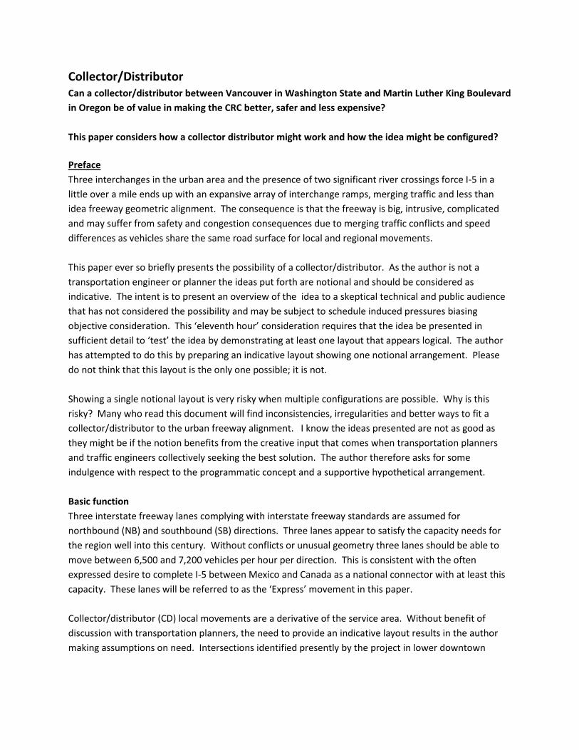
Single point interchange located between Victory Blvd and Schmeer Road
Note how this interchange can feed many vehicles directly into Portland Meadows and Portland
International Raceway
2. Treat Denver/Victory/Schmeer/Whitaker as an integrated connection of arterials that connects
the freeway with destinations. This might be accomplished with Victory feeding SB I-5
movements and acting as the exit from NB I-5. Schmeer would then feed NB I-5 and acts as an
exit from SB I-5. Surface streets then act as ‘mini’ collector distributors.
Plan of ramps to and from I-5 utilizing both Schmeer and Victory
Both of these ideas and future capacity requirements of I-5 suggest that the I-5 bridge over the
Columbia Slough will likely need to widen. This is most intriguing as the grade issue and proximity to the
unique configured North Columbia Blvd freeway ramps may result in combining SB ramps from the SPUI
or Victory on-ramps with the SB I-5 ramp from North Columbia Blvd.
Either solution places the CD/express merge at MLK a distance of 3,200’ to 3.400’ from an interchange in
the Schmeer/Victory vicinity.

I have not had opportunity to discuss the Oregon side of the CD/Express idea with ODOT or PDOT
people. This is unfortunate as I am certain that these agencies have spent considerable time considering
how this section of the freeway can be improved. This knowledge is extremely important to consider
and I hope that discussions with these two transportation authorities can occur.
Long term implication to downtown Portland
Many people have expressed anxiety that any improvement to I-5 that adds capacity to the freeway is
not wise until such time as the issue of throughput in downtown Portland is resolved. This issue is
important to understand and should be considered by civic leaders at the earliest opportunity.
However, the I-5 transportation corridor is the primary north/south transportation corridor and, in my
opinion, should continue in this role for the next few centuries. To do otherwise is to channel future
regional movement increases through established neighborhoods or suggest that regional trips will
diminish or be denied by inadequate transportation infrastructure. Given the growth in regional
secondary urban centers and reluctance to develop true high capacity transit corridors and systems it is
highly unlikely that a regional viable high capacity transportation system will be available in the next half
century to augment the car. For example, a high speed rail system will likely take two or three decades
to develop plus a number of decades after completion to have a meaningful impact on regional travel.
That’s if we decide today to do it! With this in mind the choice to the region is to increase capacity in
the I-5 corridor or cope with more and more restrictive congestion in this century.
I view the Portland throughput issue as two different areas. One is between North Columbia Blvd and
the hillside overlooking the Willamette River valley plain. Capacity can be added to this second with a
structure that is located above the freeway and below crossing surface streets, possibly continuing the
philosophy of a CD to the city. Cross streets will likely need to rise to accomplish this and this expensive
idea. However, the cost and time needed to create another corridor and environmental and social costs
of shifting traffic to another corridor likely will be greater.
The other capacity constraint is between the hillside overlooking the Willamette valley plain and
downtown Portland that includes I-405 in Portland and the I-5 freeway along the east shore of the river.
This distance will require a very expensive investment regardless of any corridor located to the north.
Options include an express tunnel (TBM) like Seattle is building or might be part of reconstructing I-5 or
I-405. This will be a difficult issue to resolve but will most likely be required if the city is to grow as a
destination. When this occurs is dependent on the ability of society to undertake the improvement and
may likely need to wait until I-5 along the east shore of the Willamette needs to be replaced or is
brought down by an earthquake.
However, every effort should be made to leverage the freeway investment over the Columbia River to
provide maximum flexibility accommodating rubber tire and steel wheel modes. This includes a
structure and alignment allowing one or two rail lines to be added to the initial LRT. This then allows
high capacity to the mix of transportation modes available to planners as they sort out opportunities to
relieve Portland capacity constraints.

North of the Columbia River
Overall plan of the CD and idea between the Columbia River and Mill plain
Note that the freeway is flanked by two outside lanes between Mill Plain and Vancouver so that no
traffic conflicts exist between the Mill Plain ramps and the separation of CD and Express lanes. This is a
distance of +/-2,400’
Downtown Vancouver and SR-14
Downtown Vancouver and SR-14 connect with the CD at the north shore of the Columbia River. The
North abutment and landside transition structure is configured to so that a simple 90 degree turn
connects EB and WB SR-14 with the I-5 CD on the Columbia River bridge. SB I-5 to EB SR-14 movement
utilizes a ramp that descends below Third Street. WB SR-14 to NB I-5 is by an elevated ramp.
Downtown linkages are facilitated by Third Street (to NB I-5, from SB I-5, to EB SR-14 and from WB SR-
14), Columbia Way (from NB I-5) and at 6th and ‘C’ Street (to SB I-5).
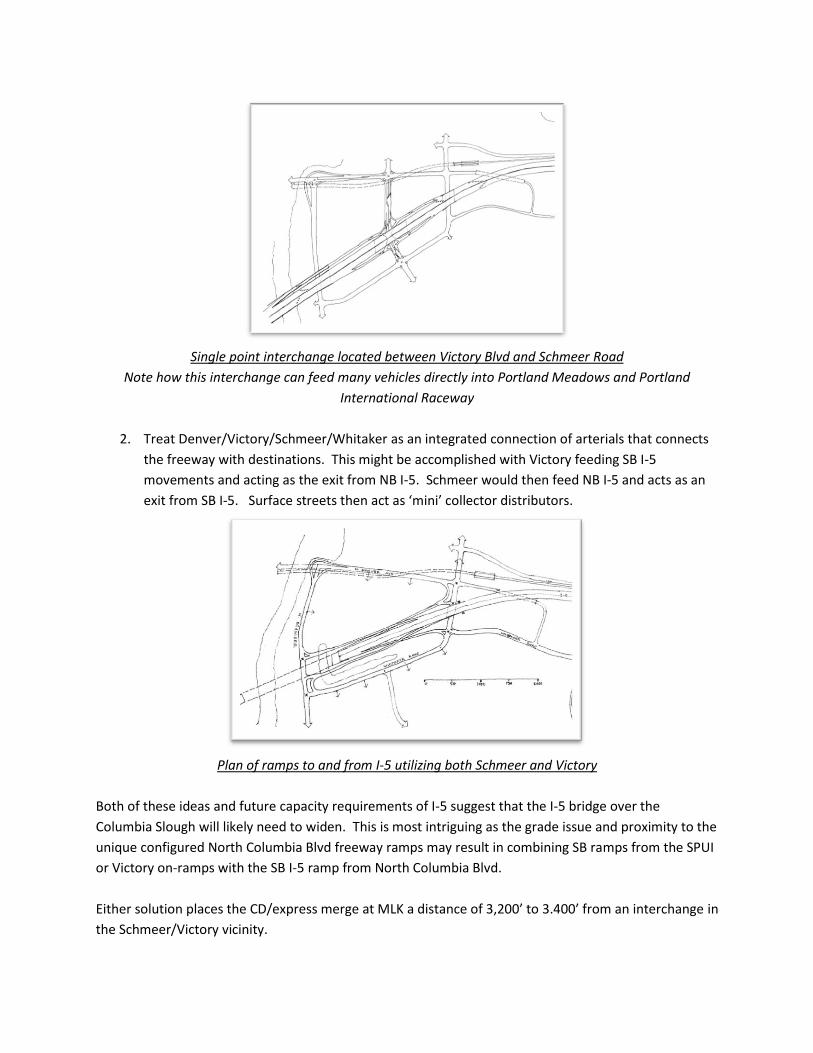
Plan of CD level at SR-14 and downtown Vancouver
Note the light rail line to the top. To the right the freeway passes adjacent to the historic hospital at Fort
Vancouver (the rectangle just under the freeway to the right of the sketch).
This arrangement merges the CD with Express lanes at a location above Third Street. The 90 degree turn
between the I-5 CD and SR-14 is a radius of approximately 500’ to the median between lanes. The same
radius holds for the WB SR-14 to NB I-5 ramp. This allows a speed of 35 mph.
Downtown access to Vancouver from NB I-5 requires a ramp that descends to the east until low enough
to pass under the BNSF railroad. This is a distance approximately 1000’ east of I-5 and utilizes SE
Columbia Way to access downtown Vancouver on a route that enjoys the Columbia River and
redeveloped waterfront.
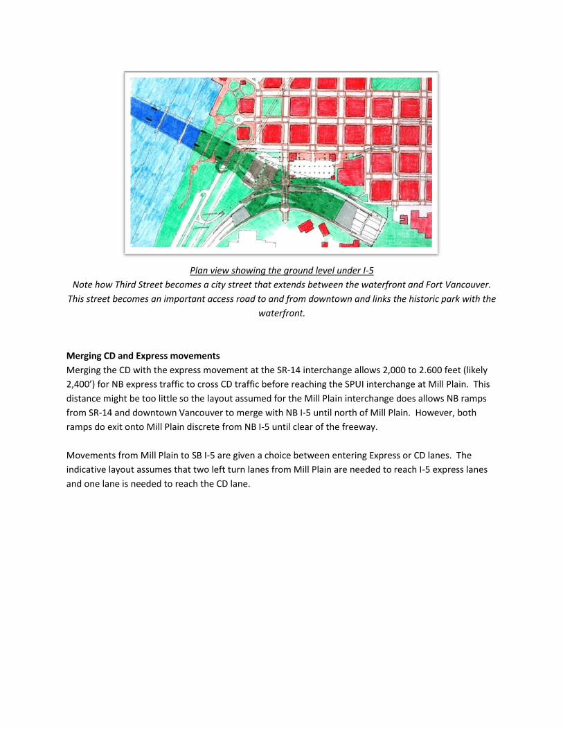
Plan view showing the ground level under I-5
Note how Third Street becomes a city street that extends between the waterfront and Fort Vancouver.
This street becomes an important access road to and from downtown and links the historic park with the
waterfront.
Merging CD and Express movements
Merging the CD with the express movement at the SR-14 interchange allows 2,000 to 2.600 feet (likely
2,400’) for NB express traffic to cross CD traffic before reaching the SPUI interchange at Mill Plain. This
distance might be too little so the layout assumed for the Mill Plain interchange does allows NB ramps
from SR-14 and downtown Vancouver to merge with NB I-5 until north of Mill Plain. However, both
ramps do exit onto Mill Plain discrete from NB I-5 until clear of the freeway.
Movements from Mill Plain to SB I-5 are given a choice between entering Express or CD lanes. The
indicative layout assumes that two left turn lanes from Mill Plain are needed to reach I-5 express lanes
and one lane is needed to reach the CD lane.
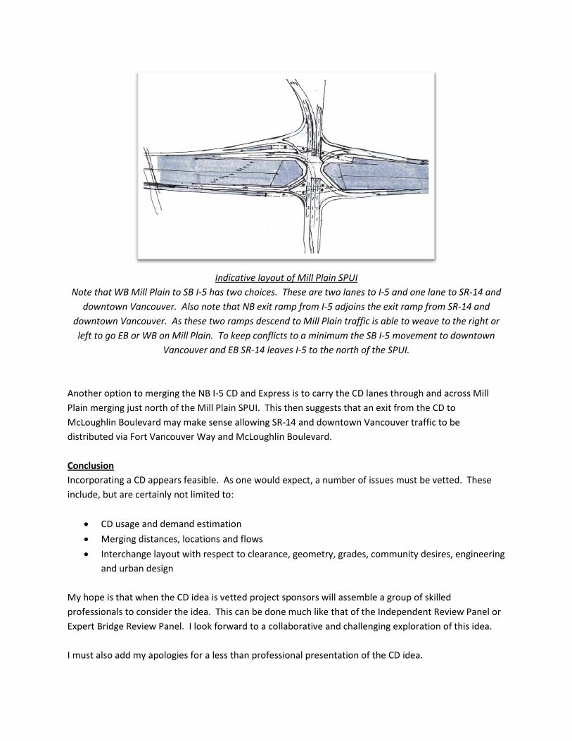
Indicative layout of Mill Plain SPUI
Note that WB Mill Plain to SB I-5 has two choices. These are two lanes to I-5 and one lane to SR-14 and
downtown Vancouver. Also note that NB exit ramp from I-5 adjoins the exit ramp from SR-14 and
downtown Vancouver. As these two ramps descend to Mill Plain traffic is able to weave to the right or
left to go EB or WB on Mill Plain. To keep conflicts to a minimum the SB I-5 movement to downtown
Vancouver and EB SR-14 leaves I-5 to the north of the SPUI.
Another option to merging the NB I-5 CD and Express is to carry the CD lanes through and across Mill
Plain merging just north of the Mill Plain SPUI. This then suggests that an exit from the CD to
McLoughlin Boulevard may make sense allowing SR-14 and downtown Vancouver traffic to be
distributed via Fort Vancouver Way and McLoughlin Boulevard.
Conclusion
Incorporating a CD appears feasible. As one would expect, a number of issues must be vetted. These
include, but are certainly not limited to:
CD usage and demand estimation
Merging distances, locations and flows
Interchange layout with respect to clearance, geometry, grades, community desires, engineering
and urban design
My hope is that when the CD idea is vetted project sponsors will assemble a group of skilled
professionals to consider the idea. This can be done much like that of the Independent Review Panel or
Expert Bridge Review Panel. I look forward to a collaborative and challenging exploration of this idea.
I must also add my apologies for a less than professional presentation of the CD idea.