Participatory rural appraisal: Vulnerability study of ... · Participatory rural appraisal –...
60
PARTICIPATORY RURAL APPRAISAL – VULNERABILITY STUDY OF AYEYARWADY DELTA FISHING COMMUNITIES IN MYANMAR AND SOCIAL PROTECTION OPPORTUNITIES FAO Fisheries and Aquaculture Circular FIAP/C1177 (En) ISSN 2070-6065
Transcript of Participatory rural appraisal: Vulnerability study of ... · Participatory rural appraisal –...

PARTICIPATORY RURAL APPRAISAL – VULNERABILITY STUDY OF AYEYARWADY DELTA FISHING COMMUNITIES IN MYANMAR AND SOCIAL PROTECTION OPPORTUNITIES
FAO
Fisheries and
Aquaculture Circular
FIAP/C1177 (En)
ISSN 2070-6065


FAO Fisheries and Aquaculture Circular No. FIAP/C1177 (En)
PARTICIPATORY RURAL APPRAISAL: VULNERABILITY STUDY OF AYEYARWADY DELTA FISHING COMMUNITIES IN MYANMAR AND THEIR SOCIAL PROTECTION OPPORTUNITIES
Aung Kyaw Thein
Richard Gregory
Michael Akester
Florence Poulain
Romain Langeard
9

Required citation: Thein, A. K., Gregory, R., Akester, M., Poulain, F. and Langeard, R. 2019. Participatory rural appraisal- Vulnerability study of Ayeyarwady Delta fishing communities in Myanmar and social protection opportunities. FAO Fisheries and Aquaculture Circular no.1177. FAO. Rome. 56 pp. Licence: CC BY-NC-SA 3.0 IGO.
The designations employed and the presentation of material in this information product do not imply the expression of any opinion whatsoever on the part of the Food and Agriculture Organization of the United Nations (FAO) concerning the legal or development status of any country, territory, city or area or of its authorities, or concerning the delimitation of its frontiers or boundaries. The mention of specific companies or products of manufacturers, whether or not these have been patented, does not imply that these have been endorsed or recommended by FAO in preference to others of a similar nature that are not mentioned.
The views expressed in this information product are those of the author(s) and do not necessarily reflect the views or policies of FAO.
ISBN 978-92-5-131217-9 © FAO, 2019
Some rights reserved. This work is made available under the Creative Commons Attribution-NonCommercial-ShareAlike 3.0 IGO licence (CC BY-NC-SA 3.0 IGO; https://creativecommons.org/licenses/by-nc-sa/3.0/igo/legalcode/legalcode).
Under the terms of this licence, this work may be copied, redistributed and adapted for non-commercial purposes, provided that the work is appropriately cited. In any use of this work, there should be no suggestion that FAO endorses any specific organization, products or services. The use of the FAO logo is not permitted. If the work is adapted, then it must be licensed under the same or equivalent Creative Commons licence. If a translation of this work is created, it must include the following disclaimer along with the required citation: “This translation was not created by the Food and Agriculture Organization of the United Nations (FAO). FAO is not responsible for the content or accuracy of this translation. The original [Language] edition shall be the authoritative edition.
Disputes arising under the licence that cannot be settled amicably will be resolved by mediation and arbitration as described in Article 8 of the licence except as otherwise provided herein. The applicable mediation rules will be the mediation rules of the World Intellectual Property Organization http://www.wipo.int/amc/en/mediation/rules and any arbitration will be conducted in accordance with the Arbitration Rules of the United Nations Commission on International Trade Law (UNCITRAL).
Third-party materials. Users wishing to reuse material from this work that is attributed to a third party, such as tables, figures or images, are responsible for determining whether permission is needed for that reuse and for obtaining permission from the copyright holder. The risk of claims resulting from infringement of any third-party-owned component in the work rests solely with the user.
Sales, rights and licensing. FAO information products are available on the FAO website (www.fao.org/publications) and can be purchased through [email protected]. Requests for commercial use should be submitted via: www.fao.org/contact-us/licence-request. Queries regarding rights and licensing should be submitted to: [email protected].
Cover photograph: Fisher from Papin Village in Maubin Township, Ayeyarwady, Myanmar (Michael Akester)

PREPARATION OF THIS DOCUMENT
This circular is part of the efforts by the Food and Agriculture Organization of the United Nations (FAO) to explore evidence of the linkages between poverty, social protection and natural resource management with a view to implementing programmes to empower rural communities in the transition to sustainable natural resource management and poverty reduction.
In Myanmar, with support from FAO, the WorldFish and the Pyoe Pin Institute carried out a participatory-based vulnerability study to assess the state of social protection and poverty dimensions in the Myanmar fisheries sector. 1
Participatory rural appraisal – Vulnerability study of Ayeyarwady Delta fishing communities in Myanmar and social protection opportunities (PRA-V study) seeks to inform fisheries management and social protection2 processes of the key vulnerability issues faced by fishers at five pilot sit es selected for fisheries co-management within the research programme of the Myanmar Department of Fisheries, WorldFish and FAO on an Australian Centre for International Agricultural Research (ACIAR) funded project.
An analysis of the PRA-V study information leads to some broad conclusions. The PRA-V study suggests that the most vulnerable communities are in Maubin and Hinthada. In both areas, community fisheries co-management is unlikely enough to reduce household or individual vulnerability significantly. The communities in Thabaung, Labutta and Dedaye appear to offer more livelihood opportunities for local people. In these areas, improving fishing ground access would likely have a positive effect on the overall livelihoods of people. However, the remoteness of the two coastal areas could prohibit social and economic development.
The PRA-V study also explored gender vulnerability aspects, focusing on female-headed households and individual women from fisher households. Due to the patriarchal social structure and cultural norms, many female-headed households appear to be more vulnerable than male-headed households. The PRA-V study suggests that there is gender disparity in terms of vulnerability in many communities.
Recommendations for further Ayeyarwady fisheries law reforms, fisheries management and social protection interventions that would reduce fisher household vulnerability are included in the discussion section.
1 This is a follow up to the 2015 nation-wide survey and analysis on the dimensions of poverty, vulnerability and social protection in rural communities in Myanmar, which the Myanmar Department of Rural Affairs (DRD) commissioned with the support from the Food and Agriculture Organization of the United Nations (FAO): FAO. 2016. Report of the Workshops to present the initial research findings from a nation-wide survey and analysis on social protection and poverty dimensions in support of rural development and poverty reduction in Myanmar, Nay Pyi Taw and Yangoon, Myanmar, 29–30 September 2015. FAO Fisheries and Aquaculture Report No. 1126. Rome, Italy. The survey can be found on line at the following address: http://www.fao.org/3/a-i5348e.pdf2 Social protection, as defined by the United Nations Research Institute for Social Development, consists of policies and programmes designed to reduce poverty and vulnerability by promoting efficient labour markets, diminishing people's exposure to risks and enhancing their capacity to manage economic and social risks, such as unemployment, exclusion, sickness, disability and old age.
iii


Contents
Abbreviation and acronyms ..................................................................................................................................... viii
1 - Introduction ................................................................................................................ 1 1.1. Introduction to the participatory rural appraisal vulnerability study ....................................... 1 1.2. Vulnerability – the Delta context ................................................................................................................ 2 1.3. Objectives and research questions ............................................................................................................ 3
2. Methodology ............................................................................................................ 42.1. Participatory rural appraisal levels .......................................................................................................... 4 2.2. Developing participatory rural appraisal vulnerability tools ........................................................ 4
3. Results ...................................................................................................................... 6Site 1 Inn Gyi Hinthada ................................................................................................................................................... 6
Background to Site 1 ........................................................................................................................................................... 6 Table 2 Inn Gyi village information .............................................................................................................................. 6 Village profile information ............................................................................................................................................... 6 Table 3 Inn Gyi village land use ...................................................................................................................................... 6 Land use ..................................................................................................................................................................................... 6 Timeline highlights ............................................................................................................................................................... 7 Livelihoods ................................................................................................................................................................................ 7 Inn Gyi is a large village of 196 households .............................................................................................................. 7 Fishing ........................................................................................................................................................................................ 8 Seasonality ............................................................................................................................................................................... 8 Site 1 Resource map .......................................................................................................................................................... 10 Disaster risk management ............................................................................................................................................. 11 Household economic vulnerabilities .......................................................................................................................... 11 Five capitals .......................................................................................................................................................................... 11 Conclusions ............................................................................................................................................................................ 11
Site 2 Thabaung .............................................................................................................................................................. 12 Background to Site 2 villages ....................................................................................................................................... 12 Infrastructure and assets................................................................................................................................................ 12 Land use .................................................................................................................................................................................. 12 Site 2 Resource Map .......................................................................................................................................................... 14 Timeline .................................................................................................................................................................................. 15 Livelihoods ............................................................................................................................................................................. 16 Fishing ..................................................................................................................................................................................... 16 Seasonality ............................................................................................................................................................................ 16 Disaster risk management pre-Cyclone Nargis and currently ...................................................................... 17 Household economic vulnerabilities .......................................................................................................................... 17 Five capitals .......................................................................................................................................................................... 18 Conclusions ............................................................................................................................................................................ 18
Site 3 Maubin ................................................................................................................................................................... 18 Background to Site 3 villages ....................................................................................................................................... 18 Infrastructure and assets................................................................................................................................................ 19 Land use .................................................................................................................................................................................. 19
v

Timeline .................................................................................................................................................................................. 19 Site 3 Resource map .......................................................................................................................................................... 21 Livelihoods ............................................................................................................................................................................. 22 Fishing activities ................................................................................................................................................................. 23 Seasonality ............................................................................................................................................................................ 23 Disaster risk management ............................................................................................................................................. 24 Household economic vulnerabilities .......................................................................................................................... 24 Five capitals .......................................................................................................................................................................... 25 Conclusions ............................................................................................................................................................................ 26
Site 4 Dedaye ................................................................................................................................................................... 26 Background to Site 4 villages ....................................................................................................................................... 26 Infrastructure and assets................................................................................................................................................ 26 Land use .................................................................................................................................................................................. 27 Figure 17 Tha Kyar Hin Oe and Nyi Naung associated with coastal fishery .......................................... 27 Site 4 Resource map .......................................................................................................................................................... 28 Figure 18 Tha Kyar Hin Oe and Nyi Naung associated with a coastal fishery ...................................... 28 Timeline .................................................................................................................................................................................. 29 Seasonality ............................................................................................................................................................................ 30 Livelihoods ............................................................................................................................................................................. 30 Fishing ..................................................................................................................................................................................... 31 Disaster risk management ............................................................................................................................................. 31 Household economic vulnerabilities .......................................................................................................................... 32 Five capitals .......................................................................................................................................................................... 34 Conclusions ............................................................................................................................................................................ 34
Site 5 Labutta ................................................................................................................................................................... 35 Background to Site 5 villages ....................................................................................................................................... 35 Infrastructure and assets................................................................................................................................................ 35 Land use .................................................................................................................................................................................. 35 Site 5 Resource map .......................................................................................................................................................... 36 Figure 20 Ah Ya Taw and Yae Twin Seik associated with a coastal fishery ........................................... 36 Timeline .................................................................................................................................................................................. 37 Livelihoods ............................................................................................................................................................................. 39 Seasonality ............................................................................................................................................................................ 39 Disaster risk management ............................................................................................................................................. 39 Household economic vulnerabilities .......................................................................................................................... 40 Individual vulnerabilities................................................................................................................................................ 41 Conclusions ............................................................................................................................................................................ 42
4. Discussion ............................................................................................................... 42
5. Conclusions ................................................................................................................ 46
vi

Acknowledgements
The authors would like to thank the fisherfolk of the Ayeyarwady Delta Myanmar and the Department of Fisheries for their collaboration.
vii
Abbreviations and acronyms
ACIAR DRMDRRFDA NAGNGOPRAPRA-V
Australian Centre for International Agricultural Research Disaster Risk ManagementDisaster Risk ReductionThe Department of Food and Drug Administration Networks Activity GroupNon-governmental OrganizationParticipatory Rural AppraisalParticipatory rural appraisal – Vulnerability study of Ayeyarwady Delta fishing communities in Myanmar and social protection opportunities
viii

1
1 - Introduction
1.1. Introduction to the participatory rural appraisal vulnerability study
Fisheries co-management projects, bringing together fisher communities, government, non-governmental organizations (NGO) and research organizations, represent the best opportunity for developing and sustaining inland and delta fisheries in Myanmar. Each partner brings different competencies, field-tested experiences and an extensive network of communities, service providers and trading networks into the process.
Vulnerability can be defined as the extent to which an activity or a group of persons is exposed to a hazard, and also the extent to which they are able to respond or adapt. It also includes socio-economic characteristics (e.g. poverty and employment rates, age of the population, power dynamics). The Participatory rural appraisal – Vulnerability study of Ayeyarwady Delta fishing communities in Myanmar and social protection opportunities (PRA-V study) seeks to inform fisheries management and social protection processes of the key vulnerability issues faced by fishers at the five pilot sites selected for fisheries co-management. The five co-management sites are located in: Labutta, Pyapon, Maubin, Hinthada and Thabaung townships (Figure 2). All sites have a t least one villa ge t ha t is implementing a rudimentary form of fisheries co-management. Two of the sites (Labutta and Pyapon) are in coastal saline areas, two are in freshwater areas (Hinthada and Thabaung) while the fifth site (Maubin) is in an area inland that alternates between freshwater and brackish conditions.
Figure 1. Fishers at Papin village, Maubin, Ayeyarwady with a mix of freshwater fish from a floodplain fishery (Photo credit: Michael Akester, WorldFish)

2
Figure 2. Map of the Ayeyarwady Delta showing the five sites selected for the PRA-V study
1.2. Vulnerability – the Delta contextThe Ayeyarwady Delta can be divided into three zones: the coastal saline areas that tend to be dominated by fisher-based livelihoods and where single crop rice farming is the norm; the brackish water zone where commercial scale fishing is less common but it might be possible to grow two crops of rice; and the freshwater zone where extensive floodplain fisheries sit alongside multiple rice cropping areas (Figure 3). Each of these areas exhibits different vulnerability characteristics, and the communities in these areas use different coping strategies to overcome hardships.
Figure 3. Delta salinity fronts: March and November (source Eric Baran).
The fishing and farming communities of the Delta have long learned to live with a range of threats from nature that have the potential to increase vulnerability. These include floods, droughts, saline intrusion, potable water shortages, crop diseases and storms. In many areas, communities have also had to bear the brunt of laws and policies that have effectively harnessed their labour for the

3
systematic extraction of natural resources from the Delta, all at the expense of the impoverished people who live there. In May 2008, Cyclone Nargis demonstrated how ill-prepared and vulnerable many Delta communities were in the face of a large-scale disaster. Since that time, many communities have become better prepared for climate related events and have better systems for communication (e.g. improved roads, mobile phones) to allow faster and better targeted responses, should a similar disaster occur.
Climate change is a serious issue for the people of the Delta, who depend on natural resources and seasonal changes. Climate change predictions for the region suggest an increasing frequency and severity of storms. Predictions also suggest there could be more frequent and severe drought and saline intrusion. Any such climactic changes will require concerted efforts to support and help sustain livelihoods in the area. The coastal fishing communities in this study are in some of the most exposed parts of the Delta. In some areas, the coast is exposed because mangroves, which provide a buffer from hurricanes and typhoons as well as a filter for sediment, have been cleared either for firewood, shrimp production or to make room for more rice production. Communities in inland areas could be better protected against storms but they still face a number of threats, many of them climate related, such as from storms and droughts. In the freshwater areas, tensions exist between fishers and farmers and access to natural resources is a key element affecting community and individual household vulnerability.
1.3. Objectives and research questionsThe main objectives of the study were threefold and focused on:
1. Reducing rural poverty by highlighting social protection systems that could be strengthenedin support of rural fisher communities;
2. advising on policy; and3. providing capacity development and advocacy to improve social protection systems that
foster sustainable and equitable rural development, poverty reduction and food (nutrition)security.
The study included a participatory vulnerability analysis and study to assess the state of social protection and poverty dimensions in the Myanmar fisheries sector. The research included designing tailor made participatory rural appraisal (PRA) instruments and field-testing them together with a well-being ranking analysis at a range of locations in the Ayeyarwady Delta.
Specific objectives included:
Providing a holistic understanding of vulnerability in Delta fishing communities; understanding the power dynamics in each of the local communities; assessing how different actors/groups might view resource (fisheries) co–management; identifying risks of different groups, including risks to women specifically; disaggregating data for different groups; assessing disaster risk management (DRM) and social protection plans for community-scale
threats and stresses; and creating a guide for subsequent WorldFish and other interventions to make them locally
appropriate and so they will not add to the vulnerability of marginalized groups.

4
2. Methodology
2.1. Participatory rural appraisal levelsTo understand fisher community vulnerability better, the PRA-V study was carried out at four different levels:
1. Community vulnerability, which explores issues that affect most people in each community(including climate related issues);
2. fisher group vulnerability, which looks at fisher specific vulnerability within the widercommunity context;
3. household vulnerability, which looks at the economic vulnerability of fisher households towithstand shocks; and
4. individual vulnerability, which explores the capacity of individual fishers or their spouses tolead sustainable lives and withstand shocks.
2.2. Developing participatory rural appraisal vulnerability toolsFollowing an initial orientation and planning day, conventional PRA tools (key informant interviews, seasonality, stakeholder mapping) involving the PRA-V study team were pre-tested in one village in Labutta and one village in Pathein Townships. This showed that existing PRA tools did not provide adequate insight into fisher vulnerability issues, and it led to the conclusion that the PRA-V study tools ought to be modified and/or further developed to better record fisher community and individual vulnerability issues. Pyoe Pin and the Networks Activity Group (NAG) field staff were given capacity building by involving them in the process to modify the PRA-V study tools and involving them in discussions on how to use them effectively and purposefully. Through a series of planning and development days, seven PRA tools were modified/designed specifically for the PRA-V study. These were as follows (and in Table 1):
1. Profiling village and DRM preparedness;2. mapping villages and highlighting areas of vulnerability;3. highlighting timelines of historical events where vulnerability either increased or was reduced;4. highlighting seasonality and identifying the most vulnerable issues and times of year;5. creating DRM awareness (fisher group perspectives);6. assessing household economic livelihood vulnerability; and7. assessing five capitals’ individual vulnerability, disaggregated by gender.

5
Table 1 Vulnerability framework for analysis

6
3. ResultsThis section summarizes the main PRA-V study findings from each of the five incipient co-management sites.
Site 1 Inn Gyi Hinthada
Background to Site 1 Hinthada is situated in the freshwater zone of the Delta and does not have problems with saline intrusion or coastal cyclones. Inn Gyi is a village3 on the shores of the 38-hectare Inn Gyi leasable water body. Farming is intensive probably due to abundant fresh water resources. All landowners have a Form 7 temporary land title. 4 The site is remove and access is difficult. Transportation is predominantly by motorbike.
Table 2 Inn Gyi village information
Village profile information Infrastructure and Assets Inn Gyi Pagoda 4 Monastery 1 School 1 - Primary Shops 5 Health Clinic 1 Power tillers 28 Rice mills 0 Functioning wells 50 Boats with engines 0 Canoes (bamboo rafts) 10 (94) Motorcycles5 50 Mobile phones All (196) Solar panels 28
Table 3 Inn Gyi village land use
Land use Land use issue Inn Gyi Number of households 196 Number – percentage of land owners 20 (10%) Share cropping households (3%) Number – percentage of land owners with Form 7
20 (100%)
Total acres of paddy 150 Average paddy land holding (acres) 7.5 Other farmland (common grazing) acres 70
3 The PRA-V study was only carried out in one village in Hinthada because the other villages around the Inn Gyi leasable fishery did not have fisher communities.4 Land use certificate (Form 7) is issued according to section 7 Farmland Law 2012. It can be sold, transferred and inherited. Changing the use requires permission from the Central Farmland Management Committee (paddy land) or Regional/State Farmland Management Committee (other types of farmland).5 Accessibility is difficult in the dry season, but easier in the wet season by boat.

7
Timeline highlights Gyi was established in 1945. Fishing was very good at that time but catches began to decline in 1980. Migration caused the village population to increase quickly from 1986 onward. Since the 1980s the community has had to cope with numerous shocks such as: political unrest (1986); flooding due to the failure of the main embankment (1990); and out-migration from the area (1998 onwards). Positive events occurring over the same time include: a new clinic (1986): embankment repaired (1996): no serious damage from the cyclone (2008); road improvements (2015): and the formation of the community fisheries organization (2017).
Table 4 Inn Gyi timeline of events
Year Negative events Positive events1945 Inn owners controlled fishing Village established1945 onwards Fish abundant1955 Monastic education1975 Land allocated for clinic1980 onwards Scarcity of jobs and livelihoods
Some cases of theft Decline in fish catches
1985 onwards Transportation difficult1986 Unrest broke out in the village Clinic opened
In-migration from other areas - population increased
1987 Good income for Inn fishers and farmers1988 onwards Out-migration to other areas began1990 Htin Gu Thar embankment broke
causing flooding in village1996 Embankment repaired2008 No significant damage by Cyclone Nargis2014 Telecommunication improved2015 Road conditions improved2016 Incomes increased due to migrant remittances2017 Co-management of Inn by community, and
Formation of fishers’ association2018 Scarcity of fish, enough for
consumption
Livelihoods Inn Gyi is a large village of 196 households. It is atypical of northern Delta villages in that it has a relatively large percentage (28 percent) of full-time fishers. This is likely because the village is close to the Inn.6 Fifty-three percent of households rely on casual labour either in agriculture or commercial fishing. As is typical of the northern Delta, only 13 percent of households have access to agricultural land. Ten percent of households farm their own land, and three percent of households are able to establish sharecropping arrangements with local landowners.
More than 50 percent of households survive by working as labourers in agriculture, as full-time fishers or by working other menial jobs. It is likely that this group also engages in seasonal small-scale fishing for home consumption and local sale. Almost all households in the village have to sell their labour at some time during the year. Landowners employ around 20 percent of village households for rice farming. Large-scale fishers also employ some casual labour, and there is other casual work such as
6 The word Inn means leasable fishery – hence Inn Gyi is the name of the waterbody and the village has the same name.

8
road building available at times. More than one third of households (80) have at least one member who has migrated (sometimes seasonally) to other areas such as Yangon to find work.
Figure 4 Inn Gyi labour distribution
Fishing The Inn was leased to the community in 2016 for MMK 1.45 million (USD 1 089 7 ). This rose to MMK 1.66 million (USD 1 247) in 2017. Leased fisheries typically have a minimum 10 percent year-on-year lease rate increase, regardless of the fishery yield. In this case, the 14 percent lease increase adds to the vulnerability of the production system. There is a village committee to manage the Inn, but it does not include fisherfolk. There are 73 large-scale fishers and around 100 small-scale fishers from seven nearby villages who fish the Inn. Species caught include: gourami, tilapia, catla, rohu, featherback, mrigal, climbing perch, snakehead and walking catfish. Co-management measures include: no take zones; prohibition of electro fishing, poisoning and explosives; and a closed season (except for home consumption) between May and July. Co-management appears to have resolved what had been ongoing conflicts.
Seasonality Two seasonal vulnerability issues were identified by the fisher groups: flooding and storms. Flooding is most prevalent from July to September, and storms (including whirlwinds) are most damaging from May to July. The community does not have an organized coping mechanism for flooding, perhaps because everyone is affected in the same way. However, there are coping and recovery mechanisms for storm damage, which can affect single households.
7 April 2018 exchange rate USD 1 = MMK 1 331
Land owners
10%
Share croppers3%
Full-time fishers28%
Casual labour, agriculture
15%
Casual labour, fishing and other
38%
Small business3%
Teachers/ health
workers1%
Skilled artisans2%
Inn Gyi Hinthada

9
Figure 5 Inn Gyi Hinthada, an oxbow lake (yellow lines) at the edge of a complex system of old river meanders (blue lines), and oxbow lakes on what was the Pathein (Ngawan) River that now flows further east.
Figure 6 Satellite image of Inn Gyi south of Hinthada during the mid-dry season on 27.12.2016. The permanent water area is highlighted in blue while the wet season area is shown by the yellow line. The greater area is planted with rice during the dry season.

10
Site 1 Resource map
Figure 7 Detail of Inn Gyi oxbow lake and fishing village

11
Disaster risk management The Hinthada area was not badly affected by Cyclone Nargis and so DRM measures do not appear to have been institutionalized. No precautions are being taken apart from flooding or storms/whirlwinds, but the community does help those people most badly affected by seasonal storms or flooding.
Household economic vulnerabilities Two typical households (one part-time and one full-time fishing household) were examined from an economic vulnerability perspective. The full-time fisher family has benefitted from improved access to the Inn but is vulnerable to policy change. They are worried that policies might be reversed with the community losing its rights to fish the Inn. Members of the family work part of the year as casual labourers and they are worried about the decline in available agricultural work (as more rice farmers are using machinery).8 The part-time fisher household’s situation is extremely vulnerable. They have only one person in the family earning money. They suffer regularly from both financial and natural disasters. Fishing gear, motors, chemicals and oil have to be purchased from in Hinthada, though they are able to get bamboo, wood, a boat, loans and fishing licences from the village. The family also trades betel, beans and eggplant from the village to a town collector. This family is able to support two children in university.
Five capitals The following is an analysis of sustainable livelihood capital for a male full-time fisher, a male part-time fisher and for one female part-time fisher. In all cases, financial capital was very low and human and social capital scores were low. Natural capacity was scored at the mid-level, reflecting improved access to fishing grounds. The exercise ranked the two male fishers as vulnerable and the female fisher as highly vulnerable. The example of the female fisher is below:
Figure 8 Vulnerability of a female fisher in Inn Gyi as shown by livelihood capitals
Conclusions The families of Inn Gyi Village are barely managing to make a subsistence living in an area often affected by natural disasters and where there are numerous hardships, although they have not had to cope with a major disaster in their history. Traditional village level coping mechanisms are in place for individual households hit hardest. Many households in the community are dependent on fishing for their livelihoods, whether full-time or part-time. There are fewer jobs for members of landless households in and around the villages since agriculture is becoming more mechanized. However, there are opportunities for migrant workers in the cities, which means relocating (permanently or
8 Although he is a full-time fisher, he cannot fish during the three-month closed season and has to find work as an agricultural labourer during this period.
012345HUMAN
SOCIAL
PHYSICALNATURAL
FINANCIAL
Very small angular footprint Very low social and financial capitals Low human capital Natural and physical capitals at the mid-
range Overall assessment - Highly vulnerable

12
temporarily) from the village. The women in the small sample who were interviewed appeared to be more vulnerable than the men. Although access to the Inn fishery has improved in recent years, fish catches have declined since the community took over co-management of the fishery. In addition, the annual 10 percent increase in the lease rate will eventually make the fishery untenable for local fishers.
Site 2 Thabaung
Background to Site 2 villages Thabaung Township is situated in the freshwater zone of the Delta and does not experience problems from saline intrusion or coastal cyclones. Khay Nan Inn is a seasonally flooded deep-water area that recedes to a few isolated bodies of water as the dry season progresses. It is a single crop rice growing area and is planted as the floodplain waters recede, since the water is too deep for growing rice during the monsoon.
The two villages studied, Wn Lo Kay and Lay Pwe Kone, are in the south and the north of Khay Nan Inn, respectively. Wn Lo Kay is the co-management community and is the larger of the two villages both in terms of population and arable land (Table 5).
Table 5 Wn Lo Kay and Lay Pwe Kone infrastructure and assets
Infrastructure and assets Infrastructure and assets Wn Lo Kay Lay Pwe Kone Pagoda 0 1 Monastery 0 1 School 1 - Secondary 1- Primary Shops 3 4 Rice mills 1 0 Boats with engines 20 5 Canoes 70 30 Motorcycles9 15 15 Mobile phones 70 60 Solar panels 10 8
Wn Lo Kay has more arable land and an unusually high percentage of households owning land (71.4 percent). The average paddy land holding is also greater in Wn Lo Kay.
Table 6 Wn Lo Kay and Lay Pwe Kone land use
Land use Land use issue Wn Lo Kay Lay Pwe Kone Number of households 105 73 Number – percentage of land owners 70 - (71.4%) 25 – (34.2%) Number – percentage of land owners with form 7
70 – (100%) 17- (68%)
Total acres of paddy 300 40 Average paddy land holding (acres) 4.3 acres 1.6 acres Other farmland 200 acres – cashew nut 0.5 acre- pulses
9 Accessibility is difficult in the dry season. It is easier in the wet season when boats can be used.

13
The area has a history of conflict between fishers and farmers, but this has been reduced recently. Repeated conflict over water and land use is the main reason the Department of Fisheries agreed to co-management.
Figure 9 The location of the Khay Nan Inn floodplain fishery (yellow oval) in relation to road networks and the Inn Gyi (red oval). The two parallel floodplain systems are outlined in yellow and red.

14
Site 2 Resource Map
Figure 10 The location of Lay Pwe Kone and Wn Lo Kay von the edges of the Khay Nan Inn floodplain

15
Table 7 Win Lo Kay and Lay Pwe Kone: timeline of events
Timeline Wn Lo Kay Lay Pwe Kone Year Events Coping mechanism Events Coping mechanism 1900 Village established,
monastic education Village established
1920 Village recognition from Government
Self-built village school
Rice price decline
1930 Armed conflicts Fled to safe areas 1938 Resettled in the village 1950 Storm occurred,
houses destroyed Re-established the village
1960 Storm hit, houses destroyed
Storm hit
1960–1964
Armed groups robbed village “toll” collections
Villagers fled for a few years
1966 Started a self-built learning centre
Malaria outbreak Traditional medicine
1977–1980
Armed conflict returned
Villagers fled again
1980– 1989
Responsible rice sold to Department of Trade
Built village monastery
1989 Free market for rice 1990 Forced labour by
Tatmadaw Government, incomes affected
Hired labour within the village and from other villages
1991 Health officer posted in the village tract
1995 Foot and mouth disease (cattle died)
No means to cope with disease
TV/video in village
1998 Responsible rice system scrapped, fishers fined for not having licences
2007 Outbreak of diarrhea, several people died
Used traditional medicines
2008 Nargis, no deaths, a few houses destroyed, all paddy destroyed, many cattle died
Took loan with interest on losses (fishing gear, etc.)
Nargis, no deaths, all paddy destroyed, cattle died, a few houses destroyed
2014 Floods, houses destroyed, paddy destroyed
2015 Better road-condition, mobile phones
Self-reliant power Road conditions improved, before only water transportation
2017 Land registration
Formed fishers’ group

16
Wn Lo Kay Lay Pwe Kone Year Events Coping mechanism Events Coping mechanism 2018 Many cattle died due
to diseases No solution
Livelihoods The livelihood profiles of the two villages are quite different. In Wn Lo Kay, a very high percentage (61 percent) of households own arable land. The percentage is lower in Lay Pwe Kone (34 percent), though it is still relatively high for the Delta. The number of full-time fishing households is low in Wn Lo Kay (13 percent) and very low in Lay Pwe Kone (one percent). The percentage of households living off casual labour is relatively low in Wn Lo Kay (17 percent). In Lay Pwe Kone a much higher percentage (59 percent) of households depend on casual labour. At least one member out of fifteen households in each village seasonally migrates to look for employment.
Figure 11 Wn Lo Kay and Lay Pwe Kone labour distribution
Fishing The main species caught are catla, wallago attu, rohu, featherback and snakeheads. Co-management promotes the policy of releasing featherback and snakehead broodstock back to the Inn every year.
Seasonality Villagers in Wn Lo Kay identified a range of vulnerability issues that occur during different seasons, such as: paddy infestations (November/December and February/March); transportation difficulties (wet season); flooding (August – October); forest fires (dry season); elephants (October – December); and illness (wet season). Their coping strategies include: more systematic planting with more insecticides to deal with rice pests; using mobile phones since the service has improved recently to communicate on issues such as forest fires and elephants; and improved awareness about health issues, especially preparing potable water to reduce health vulnerabilities
Land owners
61%
Full-time fishers
13%
Casual labour paddy13%
Casual labour fishing
4%
Small businesses
3%
Teachers / health workers
4%
Skilled artisans
2%
Wn Lo Kay - Thabaung
Land owners
34%
Full-time fishers
1%
Casual labour paddy59%
Small businesses
6%
Lay Pwe Kone - Hinthada
17
Lay Pwe Kone also experiences a regular wet season with flooding, rice pest infestations (November/December and February/March), and poor health (wet season). The villagers also identified problems from storms (July/August and October/November) and from a scarcity of employment during the wet season. Their coping strategies include: improved exchange of information on storms; evacuate households to higher land and safe zones during flooding; and diversifying crops in winter to help with employment shortages.
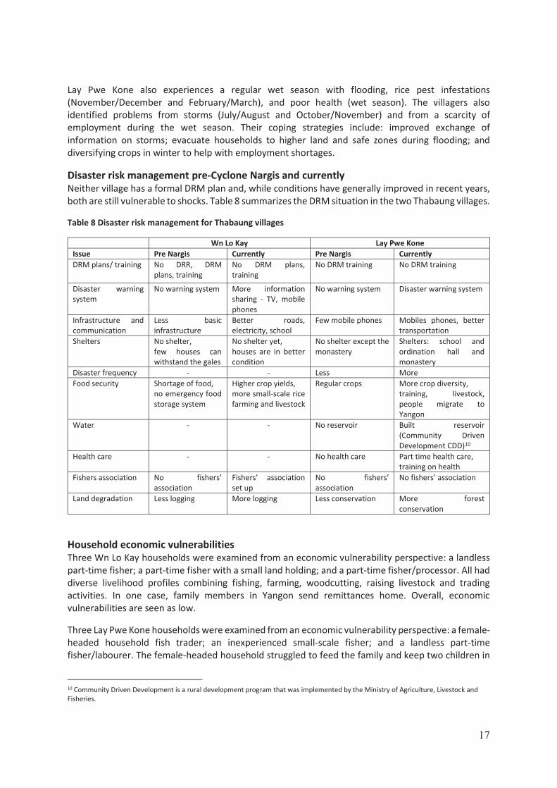
Disaster risk management pre-Cyclone Nargis and currently Neither village has a formal DRM plan and, while conditions have generally improved in recent years, both are still vulnerable to shocks. Table 8 summarizes the DRM situation in the two Thabaung villages.
Table 8 Disaster risk management for Thabaung villages
Wn Lo Kay Lay Pwe Kone Issue Pre Nargis Currently Pre Nargis Currently DRM plans/ training No DRR, DRM
plans, training No DRM plans, training
No DRM training No DRM training
Disaster warning system
No warning system More information sharing - TV, mobile phones
No warning system Disaster warning system
Infrastructure and communication
Less basic infrastructure
Better roads, electricity, school
Few mobile phones Mobiles phones, better transportation
Shelters No shelter, few houses can withstand the gales
No shelter yet, houses are in better condition
No shelter except the monastery
Shelters: school and ordination hall and monastery
Disaster frequency - - Less More Food security Shortage of food,
no emergency food storage system
Higher crop yields, more small-scale rice farming and livestock
Regular crops More crop diversity, training, livestock, people migrate to Yangon
Water - - No reservoir Built reservoir (Community Driven Development CDD)10
Health care - - No health care Part time health care, training on health
Fishers association No fishers’ association
Fishers’ association set up
No fishers’ association
No fishers’ association
Land degradation Less logging More logging Less conservation More forest conservation
Household economic vulnerabilities Three Wn Lo Kay households were examined from an economic vulnerability perspective: a landless part-time fisher; a part-time fisher with a small land holding; and a part-time fisher/processor. All had diverse livelihood profiles combining fishing, farming, woodcutting, raising livestock and trading activities. In one case, family members in Yangon send remittances home. Overall, economic vulnerabilities are seen as low.
Three Lay Pwe Kone households were examined from an economic vulnerability perspective: a female-headed household fish trader; an inexperienced small-scale fisher; and a landless part-time fisher/labourer. The female-headed household struggled to feed the family and keep two children in
10 Community Driven Development is a rural development program that was implemented by the Ministry of Agriculture, Livestock and Fisheries.

18
the local school. Her household also depended on selling vegetables on credit, which made them vulnerable to repayment default. The inexperienced fishing family also made bricks for sale, although the local market is small. The main earner in the family also drives a motorcycle taxi in the dry season. The final household combined fishing with casual labour and carpentry but now depends more on casual labour, as fish catches have been poor in recent years. All three households were classified as vulnerable.
Five capitals Three individuals (including two women) from each village were assessed from a sustainable livelihoods, five capitals perspective. The Wn Lo Kay individuals all had low financial capital but otherwise had quite large, rounded footprints,11 supported by good natural capital. None of the Wn Lo Kay individuals were seen as particularly vulnerable. The three Lay Pwe Kone individuals also had low financial capital, but their natural capacity was fairly good. Overall their footprints were of a smaller size but of a less pointed shape, suggesting consistently low but balanced sustainable livelihoods. None of the Lay Pwe Kone individuals were seen as particularly vulnerable. There were no obvious differences between the women’s and the men’s footprints in each of the villages.
Conclusions From this study, it appears that the people of Wn Lo Kay and Lay Pwe Kone are not extremely vulnerable. Their livelihoods are diverse and supported by productive (but possibly declining) local natural resources. Although they lost assets to Cyclone Nargis, they suffered no fatalities and have been able to recover well without extensive external support. They have not received any DRM training, the lack of which could make them vulnerable to future large-scale disasters. The relatively large number of households with arable land allows for regular casual labour, although local labour opportunities are low between rice transplanting and harvest. Wn Lo Kay’s involvement in co-management should strengthen and secure livelihood fisheries components. At the household level, Wn Lo Kay appears to be less vulnerable to economic shocks than those in Lay Pwe Kone. At the individual level, Win Lo Kay fishers appear to be less vulnerable than their peers in Lay Pwe Kone. Women do not appear to be especially vulnerable in either of the villages.
Site 3 Maubin
Background to Site 3 villages The two villages selected for the PRA-V study in Maubin were Ta Ma Lo and Pa Yaik. These villages are in an area that has freshwater for much of the year but also suffers some saline intrusion during the dry season. The area once supported abundant fisheries but the rapid development of large-scale aquaculture farms has changed this in recent years (see timeline). Since these villages are relatively close to and have easy communications with Yangon, there is significant seasonal migration from the area.
11 Footprint refers to the shape of the diagram based on the 5 Capitals. The more rounded towards the outer edge of the diagram the more resilient the household or individual. The dependence on only one of the five capitals – less rounded diagram or footprint indicates a higher level or vulnerability.

19
Table 9 Infrastructure and assets at Ta Ma Lo and Pa Yaik
Infrastructure and assets Infrastructure and assets Ta Ma Lo Pa Yaik Pagoda 1 1 Monastery 1 1 School 1 - Primary 1 - Primary Shops 15 2 Rice mills 0 0 Boats with engines 120 20 Canoes 150 15 Motorcycles12 120 0 Cars/trucks 2 0 Power tillers 8 15 Mobile phones 350 50 Solar panels 70 5
Table 10 Land use in Ta Ma Lo and Pa Yaik
Land use Land use issue Ta Ma Lo Pa Yaik Number of households 278 67 Number – percentage land owners 18 23 Number – percentage of land owners with form 7
9 013
Total acres of paddy 140 single crop 170 Inn name (area) Ah Lay Ma Kon (120 acres) A Tay (170) Average paddy land holding (acres) 11.7 7.4 Other farmland (acres) 10 0
Timeline The villages in this area have a complex history. Around 1955, the Government introduced aquaculture to Maubin, but it was not successful due to limited technology, extensive system,14 high investment and low production. The project only covered less than 100 acres. The industry accelerated in the 1960s with technical support from China. Yet aquaculture was still a small, localized activity that was not attractive to local farmers. From the mid 90’s, the military regime started confiscating land in the Delta, including many acres of land in Maubin, through enforcement of the 1894 Land Acquisition Act. The military regime introduced the integrated model of fish and rice farming, which reinforced the acceleration of aquaculture. At this time many businesses were set up by providing privileges, bank loans and free access to land to those in power and their associates. The military regime asked the companies that were given land to invest heavily in agriculture and aquaculture.
In Ta Ma Lo companies, including local elites, invested heavily in aquaculture. It started in this village area in 1997–1998. Once the model looked profitable, companies started grabbing land without compensation. The Dr. Myint Sein Company was given three 4 000-acre parcels of land for aquaculture. Other companies compensated local landowners at a rate of MMK 400 000 per acre. In this area
12 Accessibility is difficult in the dry season. It is easier in the wet season when boats can be used. 13 The low incidence of Form 7 ownership could be a consequence of complex land access issues in the area that might have been exacerbated by the boom in fish farming. Many will technically be illegal if they have neither a land title or a Lan Na 39 certificate, which is required to convert permanently paddy land to other purposes. 14 Extensive here refers to low stocking density of fish and hence low yields per unit area.

20
fishers used to fish on productive flooded farmland and in the Ma Let To river (the name of this river means abundant crocodiles and is an indicator of how much the area has changed) on an open access basis.
Nowadays, the open access fishing grounds have shrunk beyond recognition. A Google Earth image of the area shows how hemmed in the two villages have become. Some of the fishponds are huge (up to 800 acres). Fishers can only fish some areas during the wet season and have to stop when farming starts. Daily incomes are low at around MMK 600 to MMK 1000. There are few available opportunities for work because the aquaculture firms tend not to employ local villagers. Freshwater is scarce in the dry season and sanitation is a big issue; diarrhea outbreaks are common. Villagers are suffering from the loss of access to land and fisheries.15 The villagers also suffer from blocked access to main roads and navigation canals. As a result, an estimated 70 households have migrated permanently to other areas including Yangon.
Figure 12 Ta Ma Lo and Pa Yaik associated with the Ahtet Met Kun leasable fishery, which is the blue line. The red outlined areas show large-scale aquaculture systems. Clearly, these large-scale aquaculture areas will have a negative impact on the connectivity between the fishery and the river system to the west.
15 The villagers of Pa Yaik explained their situation to the PRA team: “Before the companies came, we were quite well off. Livelihoods were stable and we could afford to send our children to school. We had good transportation along the river freely and could do good farming.”

21
Site 3 Resource map
Figure 13 Pa Yaik and Ta Ma Lo with leased fishery (blue area) and large fishpond systems that break up the connectivity between rivers and floodplains

22
Table 11 Ta Ma Lo and Pa Yaik: timeline of events
Ta Ma Lo Pa Yaik Year Events Coping mechanism Events Coping mechanism 1951 Village established 1951–2001
Only water transportation, experienced floods every year, fish abundant
1978 Built a primary school 1980 Built a primary school 1995 The deep-water pond
and farmland project built a sluicegate, reducing fish-migration by two-thirds.
1996–2013
Food security bad, fishing rights controlled by companies
Increased migration to other areas or abroad
1999 Embankment built by government and private company, better transportation
After embankment was built the companies got more involved in the Inn, affected the livelihoods of people
Most left the village
2000 Mobile telephones available
Middle school built in nearby village
2004 Earthquake, but not much loss
2007 One villager (hook-line fisher) drowned, primary school built
2008 A lot of damage, loss of houses and property during Nargis
2010 Houses destroyed due to gales
2015 Government provided a middle school, community got tender through association
Started using mobile phones
2017 Telecommunication towers erected
2018 Concrete road built
Livelihoods The livelihood profiles of the two villages are quite different. The village of Ta Ma Lo (278 households) has 18 landowner households, 12 of which are paddy farmers, while 6 have converted their paddy land to aquaculture. The local fish farms employ casual labour from 25 households in the village. Ta Ma Lo has a significant number of households (87) with members who can be considered full-time fishers. There is also a relatively large number of small businesses (18) operating in the village, some of which may be selling inputs, such as feed and supplies, for aquaculture.
The smaller village of Pa Yaik (67 households) has a different livelihood profile. Out migration has reduced the size of the village significantly, leaving behind a relatively large percentage (49%) of

23
farming and sharecropping households. No full time fishers remain, and the landless households (24) that remain engage in casual labouring and part-time fishing. This village also has a relatively large number of small businesses (10).
Figure 14 Ta Ma Lo and Pa Yaik labour distribution
Fishing activities Common fish species targeted in this area are catfish and other local species (ngakunma, ngapyinma, ngagyi, ngapanwe, ngakhunma).
Seasonality Villagers in Ta Ma Lo identified a range of vulnerability issues that occur on a seasonal basis. These include flooding (August/September), freshwater shortages (all year), and storms (May–September). Generally, there is little preparation for disasters, but people listen to the radio for news. NGOs such as Kayae Group, NAG and the company Telenor have supported villagers with cash, clothing and housing materials for rebuilding after storm damage. Freshwater shortages cause diarrhea outbreaks but the risks are reduced by drinking filtered creek water. The township health department officials occasionally come to the village. Pa Yaik also experiences regular wet season flooding (July–September). Villagers also identified storms (April–May and December–February). There is no DRM plan per se. The villagers manage most of the shocks themselves. Eighty percent of households have their own boat, which is essential during a flood. If flooding occurs during school break periods, the school buildings cannot be used for shelter. Local medicines are collected for use during disaster periods.
Land owners/fish farmers
Fish farm labour
Full-time fisher
Rice farm casual labour
Small businesses
Skilled artisans
Ta Ma Lo
Land owners/fish
farmers34%
Share croppers
15%
Part-time fisher/casual labour36%
Small businesses
15%
Pa Yaik

24
Table 12 Disaster risk management for Ta Ma Lo and Pa Yaik
Disaster risk management Ta Ma Lo Pa Yaik
Issue Pre Nargis Currently Pre Nargis Currently Communication Dirt road Concrete Good access Irrigation blocked
(digging a pond) No mobile, no telephone
Every household has a mobile phone
No mobile phones Mobile phones
Food security - - Good Poor due to fish farms
Health No clinic Clinic - - Village size - - 150 households 67 households DRM plan No DRM plan No DRM plan Access to drinking water
Good No access Good access No access
Fisher association - - No fisher association
Fisher association
Household economic vulnerabilities Three Ta Ma Lo households were examined from an economic vulnerability perspective: two part-time fisher/casual labour households, and the village fish collector.
Like many households in the Delta, the first part-time fisher/casual-labour household was tied to a local collector, who provided loans that entitled the collector to buy all the fisher family’s catch at a reduced rate. The household also takes loans from a local moneylender and a revolving loan from the community fund. As 90 percent of this household’s income comes from fishing, it is possible that the community co-managed fishery has encouraged them to take out additional loans to invest in more fishing gear and to take advantage of their new circumstances. This might have increased their vulnerability.
The second part-time fisher household depends on fishing for 80 percent of its income. Members of the household also find work as casual labour at the local fish farms in November and December. The household is considering changing their main livelihood to selling housing materials, as the fishing grounds have become very narrow. They also take advances from the village fish buyer and must sell fish back to the same person often at a reduced rate. Other work performed by members of the household includes driving a motorcycle taxi. This household is also trying small-scale fish farming and have plans to sell aquaculture fish to Yangon and bring fingerlings from Yangon. The household receives regular remittances from children who have migrated to Yangon. This household is considered less vulnerable.
The village fish buyer household (female headed) has a large family of six children. Seventy percent of their annual income comes from fisheries but they also run a small shop and must work as labourers from time to time. They take loans from the village moneylender to provide fishers with cash-advances for fishing gear and tender fees in exchange for their fish catch. Fresh fish are sold through brokers to Yangon Sanpya Market. They also sell dry fish to Bayinnaung Market in Yangon. Key inputs such as ice and salt are purchased in Maubin. This household is not considered vulnerable.
25
Three Pa Yaik households were examined from an economic vulnerability perspective: a part-time fisher/ fish-trading household; a full-time fisher; and a fish processor. The part-time fisher/ fish trading household family is large (eight people including the parents). Though the husband sometimes works as a migrant worker in Yangon, fisheries account for 90 percent of their annual income. Their livelihood has been affected by shrinking access to fishing grounds. They take advances from a local fish buyer and, as a result, do not have the right to sell fish freely. The husband holds a fisher ID card and pays fishing gear tax at the Department of Fisheries township office. The family must also work as casual agricultural labour in the village. This family is not seen as especially vulnerable.
The second part-time fisher family are also large (seven family members including the parents). They have to take loans, and they buy rice, oil and food from the village on credit during the low season. They fish mainly in paddy fields or with cast nets in the creeks. They have to work as labourers in the village to make ends meet. Fish accounts for 90 percent of their annual income. This household is regarded as highly vulnerable as they depend on seasonal fishing in open access areas, which continue to shrink.
The third household is also involved in part-time fishing (July–November). They specialize in processing wild-caught tilapia, and they sell it to Yangon through brokers. Fisheries account for 70 percent of their annual income. During the low season, several family members have to go to Yangon for work where they are sometimes paid to make announcements through loudspeakers in the village. They also pay their fishing gear licence fee at the Department of Fisheries. This family is not seen as especially vulnerable due to their trading business, which appear to be able to access fish sourced from aquaculture.
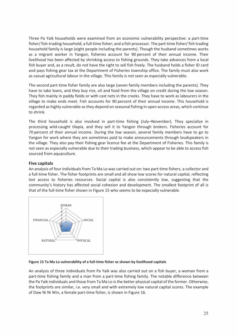
Five capitals An analysis of four individuals from Ta Ma Lo was carried out on: two part-time fishers, a collector and a full-time fisher. The fisher footprints are small and all show low scores for natural capital, reflecting lost access to fisheries resources. Social capital is also consistently low, suggesting that the community’s history has affected social cohesion and development. The smallest footprint of all is that of the full-time fisher shown in Figure 15 who seems to be especially vulnerable.
Figure 15 Ta Ma Lo vulnerability of a full-time fisher as shown by livelihood capitals
An analysis of three individuals from Pa Yaik was also carried out on a fish buyer, a woman from a part-time fishing family and a man from a part-time fishing family. The notable difference between the Pa Yaik individuals and those from Ta Ma Lo is the better physical capital of the former. Otherwise, the footprints are similar, i.e. very small and with extremely low natural capital scores. The example of Daw Ni Ni Win, a female part-time fisher, is shown in Figure 16.
012345HUMAN
SOCIAL
PHYSICALNATURAL
FINANCIAL

26
Figure 16 Pa Yaik vulnerability of Daw Ni Ni Win, a female part-time fisher as shown by livelihood capitals
Conclusions Villagers in the communities of Ta Ma Lo and Pa Yaik appear to be highly vulnerable. They are cut off from their traditional fishing and farming lands. Many in Pa Yaik have already moved away, and the trend toward out migration looks set to continue and probably spread to Ta Ma Lo as well. In this situation, the five capital analyses suggest individuals in these areas are in a more vulnerable state than in any of the other sites. It seems unlikely that improved fishery access through co-management will help. The long-term prospects for sustainable livelihoods of many fisher-livelihood households do not look good.
Site 4 Dedaye
Background to Site 4 villages The two villages selected for the PRA-V study in Dedaye Township are Tha Kyar Hin Oe and Nyi Naung. Both villages are close to the coast in a productive fishing area. Although hit very hard by Cyclone Nargis, fisheries have been especially important to the recovery in the area. NGO support (including NAG) has been crucial. Table 13 Infrastructure and assets at Tha Kyar Hin Oe and Nyi Naung
Infrastructure and assets Infrastructure and assets Tha Kyar Hin Oe Nyi Naung Pagoda 1 1 Monastery 2 1 School 1 - Primary 1 - Primary Shops 5 1 Rice mills 1 0 Boats with engines 50 23 Canoes 15 3 Motorcycles16 0 13 Cars/trucks 0 0 Power tillers 30 15 Mobile phones 300 50 Solar panels 146 50
16 Accessibility is difficult in the dry season. It is easier in the wet season when boats can be used.
012345HUMAN
SOCIAL
PHYSICALNATURAL
FINANCIAL

27
Table 14 Land use at Tha Kyar Hin Oe and Nyi Naung
Land use Land use issue Tha Kyar Hin Oe Nyi Naung Number of households 146 60 Number – percentage of land owners 27 17 Number – percentage of land owners with form 7
17 17
Total acres of paddy 720 acres single crop 200 acres single crop Inn name (area) Tha Kyar Hin OE (20 acres) 0 Average paddy land holding (acres) 26.7 acres 11.8 acres Other farmland (acres) 0 0
Figure 17 Tha Kyar Hin Oe and Nyi Naung associated with coastal fishery Mya Sein Kan and Ahkae Chaung Wa Tender

28
Site 4 Resource map
Figure 18 Tha Kyar Hin Oe and Nyi Naung associated with a coastal fishery

29
Table 15 Tha Kyar Hin Oe and Nyi Naung: timeline of events
Timeline Tha Kyar Hin Oe Nyi Naung Year Events Coping mechanism Events Coping mechanism 1910 Village established 1940 Village established,
war-torn Started to pay homage to Nat (Spirits)
1950 Co-operative system introduced, people given limited food rations
1960 Sent children to other villages for schooling before monastic education started
Village militia training
1965 Self-built primary school Village in cross-fire between armed groups
1970 Rice fields destroyed by insects
1971 Started to use radios 1974 School recognized by
Government Teacher appointed Rice price down and
recession
1975 Villagers arrested for not meeting demands of responsible rice policy
1980 Armed conflict Started to use radios Monastic education introduced 1981–1985
Actions taken against villagers for not meeting the demands of responsible rice policy
Government co-operation system abolished, villagers forced to give responsible rice and fish paste to Government
1988 Village tract clinic established
1989 Drinking water shortage, diarrhea, people died
1990 Forced labour Village clinic established 1991 Big flood, fisher /farmer
conflict Evacuate to safe zones during floods
1995 A lot of fish caught but price low. Tender system introduced-conflict
1997 No-fishing zone set up 1998 Fishers lost access to
fishing grounds. Low fish price
Monastery and temple built
Responsible rice system scrapped
1999 Fishing boundary dispute Temple built 2000–2001
Fish collecting centre opened
Fish collecting centre started
2002 Mya Sein Kan road built by Government
2004 Earthquake, some damage and loss
Self-built primary school
2008 Nargis, 30 people killed, all houses, paddy destroyed, cattle died, embankment broke, diarrhea, drinking water scarce every year since
Nargis, 160 people died, all houses, paddy destroyed, cattle died, water shortages, diarrhea
Training on DRM
2009 A shelter built by 1981/1982 old medical students’ association, embankment repaired
Red Cross – 30 houses built, Mayta No Thu Company - 60 houses, remainder self-built, young people migrated
2010 UN Habitat built village bridge, NAG provided revolving funds
Fish catches low
UN Habitant upgraded school and built a 5 000-gallon reservoir, women became more engaged in

30
Tha Kyar Hin Oe Nyi Naung Year Events Coping mechanism Events Coping mechanism
community welfare and social activities
2011 Jetty built by community 2012 Fishers fined by the
Department of Fisheries for not having licences
First migrants to other townships, started to use motorized boats, DRR trainings
ID cards issued
Shelter built by Community Based Oragnization (CBO), UNDP roads and village streets and small motorized boats, fisher association set up, community tender, village power supply
2013 Fish price low
Village power supply, village committee formed - CESIVE
Medical checks in village once a week, started to use TVs
Health-staff was appointed, revolving funds by NAG
2014 First TV in village, better fishing gear, fishing boats
Community tender, fisher association set up, bylaws developed, mangrove protection started
Start to use mobile phones
No-fishing zone set up
2015 First mobile phones Scarcity of drinking water Mangrove protection 2016 Dam built by paddy
farmers affecting navigation to village, fishers unhappy
Have to go to sea to bypass dam, increased risk to safety
Fishing ground dispute with other villages, fish catches good (Hilsa), motorcycles in village
Dispute resolved by authorities, village road repaired
2017 Village bridge (II) built with government funds
Social resettlement department provided DRP trainings, community social welfare group formed
2018 Village road repaired
Seasonality Villagers in Tha Kyar Hin Oe identified a range of vulnerability issues that occur on a seasonal basis. These include: storms (peaking in July/August and October/November); fish shortages (May/June); no employment (May/June and November/December); sickness (August/September); and livestock diseases (April/May). Nyi Naung experiences similar wet season vulnerability issues including: storms (peaking in July/August and October/November); fish deficit (May/June); transportation problems (March/April); employment shortages (April–June); and sickness (July/August and November–February). In both villages, people manage most of the shocks themselves; however, NGOs such as NAG have been present in the village since 2008 to assist where necessary.
Livelihoods Despite the villages being only two kilometres apart, their livelihood profiles are quite different. There are significantly more full-time fishers living in Nyi Naung (62 percent of households), which is closer to the sea, than in Tha Kyar Hin Oe (38 percent of households). Nyi Naung also has a larger percentage of landowner households (27 percent) than Tha Kyar Hin Oe (18 percent). The other significant difference between the two villages is the number of casual labourers: 36 percent of households in Tha Kyar Hin Oe and only 6 percent in Nyi Naung.

31
Figure 19 Tha Kyar Hin Oe and Nyi Naung labour distribution
Fishing Hilsa fishing in the main rivers. Crab fishing in the sea.
Disaster risk management Due to their proximity to the coast, both villages suffered considerably during Cyclone Nargis. Nyi Naung lost 160 people and Tha Kyar Hin Oe lost 60 people. However, both villages appear to have made significant improvements in terms of DRM since the disaster. Table 16 highlights some of the changes in the two villages.
Table 16 Disaster Risk Management for Tha Kyar Hin Oe and Nyi Naung
Tha Kyar Hin Oe Nyi Naung Pre Nargis Currently Pre Nargis Currently
No trainings on DRR and DRM
Training on DRR and DRM provided, disaster warning system established, mangrove conservation
No DRR or DRM training DRR and DRM training provided by social welfare department, draft DRM
Village youth group, women’s group,
Assistant midwife and healthcare staff, community healthcare committee, youth association (better organized), women’s association (better organized), funeral service association
Monastery, self-built school
Monastery and ordination hall
Poor infrastructure, pagoda trustee, monastery, school (self-built)
Shelter, bridges, roads, every house has mobile phones, better storage for food
Monastery, self-built school, bad transportation, poor road conditions, no electricity, only candlelight
Monastery and ordination hall, small-scale village power generation
No fishers’ association,
Fishers’ association, farmers’ association, livestock breeding group
No fishers’ association, two fish collecting centres
Fishers’ association formed, revolving fund
Poor transportation and communication
Motorized boats, mobiles phones Only paddle boats Motorized boats, motorcycles, tractors, mobiles phones
Rice and Inn farmers’ conflicts
Inn and rice farmers’ conflicts reduced
Fishers’ conflicts “No-fish” zone set up, mangrove planted, conservation, fishers’ conflicts significantly reduced, community fish rules set
Land owners/
fish farmers
18%
Full-time fishers
38%
Casual labour36%
Small businesses
7%
Skilled artisans
1%
Tha Kyar Hin Oe
Land owners/
fish farmers27%
Full-time fishers
62%
Casual labour/ farming
6%
Small businesses
5%
Nyi Naung

32
Household economic vulnerabilities Six households were assessed from an economic vulnerability perspective in Tha Kyar Hin Oe. Household #1 is a small family (a couple with one child) where the husband of the household is a part-time fisher targeting hilsa. He takes a loan from the village collector and sells his fish at a fixed price. He also takes loans from the Mya Sein Taung village fund.17 The head of the household can build boats by himself. The family also grow nipa palm to sell in the village. The head of the household must pay MMK 7 000 (USD 5.3) for his Hilsa net licence fee to the fishers’ development committee. He also raises livestock (pigs) and sells them at the local market. Fisheries work accounts for 60 percent of his income. This household is not considered especially vulnerable due to its diverse livelihood, but hilsa migrations18 can be unpredictable. The small family size increases their vulnerability. Household #2 is a small family of two (one male, one female). They specialize in dried fish processing (croaker, dwarf catfish). They collect fish from fishers in the village, they sell the dried fish at Hlaingtharyar Market once a month in the dry and cold seasons, and they grow nipa to sell in the village. They take loans from the Mya Sein Taung fund. The couple also raise pigs to sell at local markets. Fisheries accounts for 50 percent of household income. This household is not considered especially vulnerable due to diverse livelihoods. The wife works equally in the business. It is likely that they suffer cash flow problems in the wet season when drying fish is impossible.
Household #3 is a four-member family (three males, one female). The husband operates a Ba’win (comprising wooden poles and netting resembling a fence) purchased for MMK 40 (USD 3 000)19 from Yangon and a motorized boat from Kotelett. He buys bamboo and other materials from Pyapon. He bought the Ba’win licence from a local fish collector and sells the fish catch back to him. He also takes loans from the Mya Sein Taung fund and a village moneylender. Mostly, he targets dwarf catfish, crab, prawn, kanbalu and ngaponna. Also, he raises pigs in the village and sells them in Pyapon and Kotelett. Fisheries account for 95 percent of their income. This household is heavily dependent on fishing for their livelihood. It should be noted that Ba'win fishing gear is technically illegal and is, therefore, vulnerable to policy change or law enforcement. This household’s current assets have considerable value, which can be used as collateral or sold if necessary.
Household #4 is a family of four (two males, two females). The husband is a small-scale fisher who sells to the main village collector. He takes cash advances from the collector to buy fishing gear in the village. He also takes loans from the Mya Sein Taung fund and pays two percent interest per month. He fishes for hilsa and buys vegetables from Pyapon (Figure 17), which he sells in the village. They also raise pigs to sell at the Pyapon market. A hilsa licence costs MMK 5 000 MMK (USD 4) from the Fishers Development Committee. Fisheries account for 55 percent of household income. This household is not considered especially vulnerable due to its diverse livelihood and household manpower. The seasonality of hilsa might affect cash flow.
Household #5 is a family of three (two males, one female). This is a part-time fisher family. They take loans from the Mya Sein Taung fund and have a licence from the Department of Fisheries. They purchase their fishing gear in Pyapon. They sell fish to the collector and also to the village fishers’ group. They have to buy drinking water from water carriers. They buy rice bran from the rice-mill in
17 Mya Sein Taung is a Buddhist fund that makes donations to help communities at times of crisis.18 There are more tidal barrages being built to improve saline-free irrigation water for rice cultivation. These barrages have no fish passes; hence, the hilsa fisheries have been negatively impacted by these barrages, some of which are large. 19 A Lakh is a unit = 100,000 hence here its 4,000,000.

33
town and raise livestock, especially pigs, which they sell in the village. Fisheries accounts for 70 percent of the household’s livelihood. This household is not considered especially vulnerable due to its quite diverse livelihood. They are well connected to collectors, the Department of Fisheries and to village organizations.
Household #6 is a family of five (one male, four females). The women have to help their father/husband with hilsa fishing. They bought a net in Yangon at the local market. They take loans from both the village collector and the Mya Sein Taung fund. They sell fish to the village collector at a price less than the market. A licence for a hilsa net cost MMK 7 000 (USD 5) from the Department of Food and Drug Administration (FDA). The family also raises pigs to sell in the village. Fisheries accounts for 95 percent of household income. This household is considered vulnerable due to their specialization in hilsa, which is seasonal and shows large variation in annual catches. Six households were also assessed from an economic vulnerability perspective in Nyi Naung. Household #1 is a large family of nine. They target hilsa and sea crabs. They buy fishing gear in Pyapon and use a lobster net (diamond net) to catch crab at sea. They take loans from the village collector and they sell hilsa back to the village collector. They sell crabs in Pyapon. The family members also work as casual labourers cutting wood and carrying rice-baskets, where they earn MMK 3 000 (USD 2) per day. They raise pigs to sell in Pyapon (Figure 17). One member of the family has a fisher ID card and a fishing gear licence from the Dedaye Department of Fisheries. Fisheries account for 90 percent of household income. This household is not considered so vulnerable despite being fishery dependent. Such a large family can diversify their income through casual labour and other village activities. Household #2 is a family of five (three are children). They sell fish, crab, hilsa and pigs in Pyapon. They take loans from the village revolving fund, buy fishing gear in Pyapon and a fishing gear licence from the Dedaye Department of Fisheries. They sometimes sell fish to the village collector. Sometimes they work as casual labour in the village and raise pigs, but fishing provides their main source of income accounting for 80 percent of household income. This household is not considered so vulnerable their dependence on fishing. They have a moderately diversified income from casual labour and trade.
Household #3 is a family of three (one child). They are full-time fishers who set lobster nets in the dry season for crabs and set Katpalay nets for hilsa in the wet season. They take loans from the village revolving fund. They also take loans and buy gasoline from the village collector, and they sell hilsa to the village collector. They sell other fish in Pyapon. This household is fully dependent on fisheries for their entire household income. This household is considered vulnerable because it is totally dependent on fishing for its livelihood, the family is small and they are unable to withstand shocks such as ill health or fish stock decline.
Household #4 is a family of five. The husband is a part-time fisher/farmer. They own some paddy land and do not need to take a loan from the village revolving fund; but they do take loans from the village collector. The husband does not have a fisher ID card and has to pay licence fees. He sells hilsa to the village collector and sends crab to Pyapon. The village collector provides gasoline, which must be paid back weekly. He buys fishing gear in Pyapon and a fishing gear licence from the district Department of Fisheries. He cuts nipa leaves and sells them in town, sells rice in Pyapon, and he has also taken a loan from a bank in town. Fisheries accounts for 60 percent of household income. This household is not especially vulnerable because of its diverse livelihoods, including paddy farming. They have access to multiple credit avenues. This household can probably withstand shocks easily.

34
Household #5 is a family of three (one child). They catch crabs in paddy fields and in the sea. Crabs are sold live for MMK 3 000 to MMK 10 000 MMK (USD 2 to 7) per kilogram. They buy fishing gear in Pyapon and sell catches directly to a collector in Pyapon. Sometimes the husband has to work as a fishing labour for a lobster net (diamond net) owner, earning MMK 2 000 (USD 1.50) for six hours per tide. He also raises pigs and sells to collectors who come from Pyapon. He has a fisher ID card and a licence from the Dedaye Department of Fisheries. Fisheries account for 90 percent of the household income. This household is vulnerable to shocks such as illness because it is a small family with a dependent child. The household is fishing dependent but specializes in crab rather than hilsa, which might be less risky. Household #6 is a family of five (with three children still in school). They are part-time fishers using a lobster net (diamond net). They bought fishing gear in Pyapon. They take advances from the village collector. They also take loans from a Pyapon rice buyer and a commercial bank (agriculture/livestock). They mainly target hilsa, which brings MMK 21 000 to 22 000 (USD 10) per kilogram. The husband has a fisher ID card and he works as a casual labourer in the village. Fisheries account for 60 percent of this household’s annual income. This household is vulnerable to shocks such as illness and natural disasters because they have three dependent children and are dependent on hilsa fishing and casual labour.
Five capitals Six individuals from each village were assessed from a sustainable-livelihoods five capitals perspective. The Tha Kyar Hin Oe village households were all similar in shape and size. They had quite well-rounded footprints, supported by stable natural capital. None of the individuals in this village appeared to be especially vulnerable.
The six Nyi Naung individuals were very similar to each other, with an average level of financial capital and with good, social and natural capital. All but one of the footprints were rounded in shape, suggesting consistently low but balanced sustainable livelihood profiles.
Conclusions The communities of Tha Kyar Hin Oe and Nyi Naung have made significant improvements in terms of DRM since Cyclone Nargis and appear to be better able to respond to a similar threat should it ever happen again. They have also benefitted from governmental policy changes favouring fisher livelihoods. While seasonal hardships exist, the communities (with NGO and Government support) have managed to organize themselves effectively, reducing possible shocks to individual households. Household businesses appear stable, and the family members who were interviewed had diverse livelihood portfolios and did not appear to be especially vulnerable. There are opportunities for fish processing in both villages, which encourages women to participate. All households depend on credit to start-up business each year. It is interesting to note that village revolving funds have not replaced the need for village collector financing. In many cases, fishers take on both types of loan. Of the six households assessed for economic vulnerabilities in Tha Kyar Hin Oe, two were considered to be not especially vulnerable to future shocks. Three of the six households in Nyi Naung were considered vulnerable. None of the individuals in either village were considered especially vulnerable. The similarity of footprint shape and size in the two villages suggests that the various capitals in coastal communities are more equally shared and able to support fisher livelihoods more consistently. Or, it could be a reflection of NAG having been active in the villages for several years and having worked on building capacity at individual and community organizational levels.

35
Site 5 Labutta
Background to Site 5 villages The two villages selected for the PRA-V study in Labutta township were Ah Ya Taw and Yae Twin Seik. Both villages are close to the coast in a productive fishing area. Ah Ya Taw is significantly larger than Yae Twin Seik. Due to their remote exposed position, they are among the villages hardest hit by Cyclone Nargis. As with the Dedaye villages, fisheries have been especially important in the recovery.
Table 17 Infrastructure and assets at Ah Ya Taw and Yae Twin Seik
Infrastructure and assets Infrastructure and assets Ah Ya Taw Yae Twin Seik Pagoda 1 1 Monastery 1 1 School 1 - Secondary 1 - Secondary Shops 10 7 Rice mills 0 0 Drinking water ponds 10 2 Wells 0 0 Boats with engines 100 60 Canoes 20 3 Motorcycles20 2 3 Cars/trucks 0 0 Power tillers 0 5 Mobile phones 300 50 Solar panels 100 30
Table 18 Land use in Ah Ya Taw and Yae Twin Seik
Land use Land use issue Ah Ya Taw Yaw Twin Seik Number of households 326 75 Number – percentage of land owners 8 5 Number – percentage of land owners with form 7
7
Total acres of paddy 700 single 200 single Inn /tender name (area) Thaung Mu River 6 sq miles Thaung Du River
3 sq miles Average paddy land holding (acres) 87.5 40.0 Other land (acres) 0 400 acres (mangrove)
20 Accessibility is difficult in the dry season, but is easier in the wet season when boats can be used.

36
Site 5 Resource map
Figure 20 Ah Ya Taw and Yae Twin Seik associated with a coastal fishery

37
Figure 21 details of the Site 5 fishery (WorldFish MYFish II)
Table 19 Ah Ya Taw and Yae Twin Seik: timeline of events
Timeline
Ah Ya Taw Yae Twin Seik Year Events Coping mechanism Events Coping mechanism 1938 Village established Monastic education introduced
1950 Village recognition from Government
Self-built village school Village established armies, forcibly took properties from the village
Monastic education introduced, a self-reliance primary school set up
1951 Armed groups robbed village, “toll” collections
Villagers fled for a few days
1979 Malaria epidemic, some deaths
1980 Motorized boats introduced Some villagers arrested due to being unable to give responsible rice to the Government
1986 Villagers forced to give responsible rice and fish paste to the Government
Needed to borrow from each other to avoid action taken against them
88-89 Villagers forced to labour building bridges and roads
Armies forced villagers were forced to labour. Food shortages due to ship routes

38
Ah Ya Taw Yae Twin Seik Year Events Coping mechanism Events Coping mechanism
being suspended, private tender operators exploited the fisheries resources
1990 Village clinic established
Right to sell rice independently
Self-arranged power supply
1991 Big flood, loss of draft animals
1996 Tender system introduced, fishery access reduced
1998 Responsible rice system scrapped
Armies forced children into becoming soldiers
Primary school upgraded with help from the Government
2000 Cholera, 6 people died 2002 Conflicts occurred between
tender takers and fishers (reached court)
2003 Many fish died in the river due to pollution
2004 Earthquake, but not much loss
A few people died while gill net fishing
2006 One villager (hook line fisher) drowned
2007 Primary school built 2008 Nargis, two-thirds of
population killed, all paddy destroyed, cattle died, buildings destroyed
Red Cross built 30 houses, Mayta No Thu Company built 60 houses, remainder self-built, training on DRM, campaign to eradicate paddy rats, funeral service association
Nargis, only a quarter of total village population survived, drinking water scarce, food, farms destroyed due to saline intrusion and rats for 3 years
A nurse was appointed to conduct a medical-check in the village twice a month after Nargis
2009 Jetty built by a community organization
First TV CBOs helped build roads, reservoirs and a shelter
2010 Revolving credit funds and income generation schemes
Flood occurred, many paddy fields destroyed
2011 Shelter built by CBO, UNDP built roads and village streets and brought small motorized boats
Farmers in trouble due to paddy price decline
DRM trainings, warehouse built for better storage and production
2012 Motor boats to help people escape flooding and storms
2013 First TV purchased in village
Training of villagers, storage of food and medicine, safe evacuation of aged and children
2014 First mobile phones in village
Mobile phones reduced vulnerability by allowing for information sharing and an early warning system
2016 Self-reliant power (generator/solar) People started using mobile phones
2017 Saline water intrusion, regular paddy rat infestations, few jobs
Increasing migration, form 7s issued Fisheries co-management association formed
2018 Capture fisheries decline noticeably
Scarce drinking water every year, livestock died every year, shelter not big enough for all people

39
Livelihoods Although Ah Ya Taw and Yae Twin Seik differ in size (326 and 60 households, respectively), they are similar in terms of livelihood percentages. In both, around 50 percent of households fish full-time. The percentages of households with arable land are very low in both villages (two percentand seven percent, respectively). Individual land holdings are very high, with an average of more than 80 acres in Ah Ya Taw (much of it used for shrimp cultivation). More households in Ah Ya Taw (39 percent) depend on casual labour than in Yaw Twin Seik (21 percent).
Figure 22 Ah Ya Taw and Yae Twin Seik labour distribution
Seasonality Villagers in Ah Ya Taw identified a range of vulnerability issues that occur seasonally. These include: storms (peaking from April–July); flooding (June–November); strong waves (February–April); and livestock diseases (February–April ). Yae Twin Seik experiences similar wet season vulnerability issues including: flooding (peaking in May and June); freshwater scarcity (January–May); diarrhea (January–May); and livestock diseases (April–June). In both villages the people manage most of the shocks themselves.
Table 20 Disaster risk management for Ah Ya Taw and Yae Twin Seik
Disaster risk management Disaster risk management
Ah Ya Taw Yae Twin Seik
Issue Pre Nargis Currently Pre Nargis Currently Warning system no Yes No Yes Shelter no 2 No Shelter attached to the
primary school Communications no Mobile phones,
solar power batteries
No communication , no mobile phones,
Mobile phones, solar batteries
Land owners/
fish farmers2%
Share croppers
1%
Full-time fishers
46%Casual labour
farming 5%
Casual labour fishing
11%
Casual labour other23%
Skilled artisans
1%
Teachers/health
workers3%
Small businesses
8%
Ah Ya Taw
Land owners/
fish farmers7%
Full-time fishers
48%Casual labour
farming 8%
Casual labour other13%
Skilled artisans
8%
Small businesses
16%
Yae Twin Seik

40
Disaster risk management
Ah Ya Taw Yae Twin Seik
Issue Pre Nargis Currently Pre Nargis Currently Population More people Less through
migration Less migration More workers
migrating to other areas
Disaster frequency Less More unpredictable Weather stable Weather unstable, change, occasional rains, floods
Mangroves Abundant Degraded More mangroves Mangrove degraded (illegal logging)
DRM training No Yes No Yes Fisher association No Yes No Fishers’ association
recently formed Fish abundance - - More catch Low catch Market access - - Not much gap between
income and expense Income affected due to fixed low prices
Revolving funds - - No support UNDP supports revolving fund
Health staff - - Health staff in village, midwife assistant
Lack of healthcare staff (though healthcare committee is formed)
Household economic vulnerabilities Ah Ya Taw - Household #1. The U Min Aung family is a couple with two children. The husband is a full-time commercial fisher who operates a stow net and purse seine to catch shrimp, which he dries and sells to a local collector. He employs some casual labourers and pays them MMK 90 000 per month (USD 68). The cost of fishing gear is high; a stow net costs MMK 50 000 MMK (USD 38), and the moorings and raft cost MMK 400 000 (USD 300). The seine net cost MMK 100 000 (USD 75). He pays MMK 12 000 per year (USD 9) for a licence. The family took out a significant loan of MMK 500 000 (USD 376) from the village revolving fund. They can sell raw shrimp at MMK 10 000 per kilogram (USD 8) and dried shrimp at MMK 20 000 per kilogram (USD 15). The by-fish catch is salted and sold at MMK 50 000 to 65 000 per kilogram (USD 38 to 49). This household is not considered vulnerable due to the commercial scale of its livelihood and capital assets.
Ah Ya Taw Household #2. The Daw Tin Tin Mying family has seven members. They specialize in stow net fishing and fish processing. They sell raw shrimp in the wet season and dry shrimp in the summer to the village collector. They take an advance from the collector and have also taken MMK 350 000 (USD 263) from the UNDP funded revolving fund. This household is not considered vulnerable due to the commercial scale of its livelihood, family labour availability and capital assets.
Ah Ya Taw Household #3. The U Kyaw Moe family is a couple with one child. They are full-time shrimp fishers, but they also collect crabs from other fishers in the village and sell them to the village collector. They have taken a loan of MMK 400 000 (USD 300) from the UNDP fund. 21 This household is considered quite vulnerable due to the small size of the family and their dependency on fishing and sub-collecting (although they are possibly less vulnerable than households who rely only on fishing). Sickness or a stock decline would hit this type of household hard, affecting loan repayments that could push them deeper into debt.
Yae Twin Seik Household #1. The Ma Thay Mar family has five members (two males, three females). They are full-time fishers for mud crab and fence net fishing, which requires a licence. They buy crab
21 It is a village revolving fund that used start-up funds from UNDP in 2010 (see timeline). The fund grows as villagers repay their loans.

41
traps from Labutta (100 pieces for MMK 60 (USD 5). They fish in the village creek, which has open access, and sell crabs, prawns, dwarf-catfish, mullet and Kabalu. They take loans from the village crab collector. This household is considered vulnerable due to its dependency on fishing. They have no other livelihood activities. A decline in natural resources would affect this type of household seriously.
Yae Twin Seik - Household #2. The U Aung Myo family has three members. The family depends on crab fishing and collecting in and around the village. They provide crab traps, bait and cash to crab fishers in the village who then have to sell their catches to them. Crab traps are purchased in Labutta. Sometimes they have to take loans from the village moneylender. This family is considered quite vulnerable due to its dependency on fisheries, although being one-step removed from the actual practice of fishing offers them some protection against stock or price declines. The fact that they only take out loans sometimes suggests that they might have some savings or other assets that they can liquidate as required.
Yae Twin Seik - Household #3. The U Tin Aye family has three members. One member is a full-time, casual fisher. He obtains crab traps from household #2 above and sells crabs to the collector at a fixed price. This household has no other livelihood activities. This household is extremely vulnerable due to the small size of the family and its dependency on fishing. They have no fisheries assets of their own. They are forced to sell their catch at a low price.
Individual vulnerabilities Four individuals from Ah Ya Taw were assessed from a sustainable livelihoods, five capitals perspective. A wide range of results were achieved, which suggests a great disparity between the various types of fishers in the community. As can be seen in Figure 23, U Tin Aye has very low physical capital, having to rent crab traps and a boat on a short-term basis. His financial capital is also weak. His strongest capital is social. In contrast is the result from U Min Aung, a stow net/seine net fisher who regularly employs casual labour. U Min Aung is also able to make some savings from his business. The result is a well-rounded 5 capital diagram except for some financial capital concerns. The other individuals analyzed showed intermediate results but were generally weak on financial capital due to tied credit relationships and the lack of local markets, which makes it necessary to use middlemen/collectors.
U Tin Aye (from Household #3) U Min Aung (from Household #1)
Figure 23 Yae Twin Seik and Ah Ya Taw vulnerability among fishers, as shown by livelihood capitals
Six individuals from Yae Twin Seik were also assessed. All but one household produced small but well-rounded capital footprints. The exception being one part-time fisher who had to rent fishing
0.01.02.03.04.05.0
HUMAN
SOCIAL
PHYSICALNATURAL
FINANCIAL
0
1
2
3
4
5HUMAN
SOCIAL
PHYSICALNATURAL
FINANCIAL

42
equipment and a boat (Figure 23, left side). Natural capital scores ranged widely suggesting some disparity in fishery access, or the quality of natural resources. All individuals had low financial capital and were surprisingly weak in terms of social and human capitals. This could be due to the absence of NGOs or government programmes aimed at strengthening individual and village organizational capacity.
Conclusions Cyclone Nargis devastated the communities of Ah Ya Taw and Yae Twin Seik. Ah Ya Taw lost 66 percent of its people and Yae Twin Seik lost 75 percent. With the support of external agencies, recovery has been achieved, though more so in Ah Ya Taw. Many households in the two villages completely depend upon fishing for their livelihoods, and financing these livelihoods remains a challenge for many of them. Fishers in Ah Ya Taw still depend on traditional moneylenders and village collectors for financing, while in Yae Twin Seik, UNDP revolving funds have supported some fishers. An economic vulnerability assessment suggests that households in Ah Ya Taw are less vulnerable than in Yae Twin Seik. The remoteness of the two sites gives fishers few choices for marketing outside the value chain of sub collectors and collectors for the resources they extract from the Delta. Low market prices may encourage more fishing, which risks depleting the local resources. As with the Dedaye sites, there are opportunities for fish processing and this encourages women’s involvement in fisheries in the area. A fishers’ association established in Yae Twin Seik is a positive indication that fishers might receive more recognition from the Government and local institutions in the future. Individual vulnerability is, in some cases, very high while in others it is moderate to low.
4. DiscussionVulnerability contexts in terms of geographic location, social incorporation and livelihoods, climate change and the current political changes around resource access, need serious attention in the Ayeyarwady Delta Division in Myanmar. The issue of access to and over-exploitation of natural resources threatens to deepen vulnerability and undermine the prospects of sustainable development. Vulnerability contexts in Ayeyarwady are varied across villages, sectors, and social and political groups.
Small-scale fisher households depend heavily on common property resources for their survival. At the same time, there are organized efforts to develop co-management mechanisms for sustainable management and equitable benefits. Such an approach is likely to have a more positive impact on managing vulnerability and risk. This is evident from the findings from villages where incipient co-management practices are already in place such as in Nyi Naung.
Understanding the external factors and local dimensions of vulnerability are critical to support developing appropriate and targeted adaptation efforts, by considering both formal institutions (laws, policies, etc.) and informal institutions (attitudes, behaviours and practices). The Ayeyarwady Parliament and Government along with civil society organizations are making significant efforts to reform the fisheries, agriculture and land sectors. These rapid changes need immediate support to provide knowledge and more in-depth understanding of the multi-dimensional factors of vulnerability in terms of technical aspects, environmental factors and political processes associated with the democratization and decentralization of decision making.
The PRA-V study found that many of the targeted villages tend to be vulnerable to seasonal climatic events and to the adverse impacts of social and political changes, since they largely depend on livelihood-sensitive sectors like fisheries, agriculture and forestry. Many villages, especially isolated ones in Ayeyarwady Delta, are geographically disadvantaged for livelihoods assets because they are remove and accessibility is limited. Nearly two-thirds of the Ayeyarwady population live mostly on

43
remote islands and face harsh climatic effects especially wind and floods every year. Transportation is dependent on seasonal climate changes that can have severe impacts on livelihoods, safety and security. These conditions are more susceptible to climate change. Policy makers need to recognize that the effects of climate change will not be felt in isolation, but in the context of multiple stresses and shocks externally and internally.
Conventional gender roles demand that men work on farms or migrate to other areas for labour, which involves a high level of physical risk and mental stress, in order to sustain the family. Women are often expected to take a subordinate role, and this has restricted their freedom in many ways and subjected them to social pressures that directly affect the way they can cope with internal and external shocks. The PRA-V study has also attempted to explore gender vulnerable aspects, focusing on female-headed households and individual women from fisher households. Due to the patriarchal social structure and cultural norms, many female-headed households appear to be more vulnerable when compared to male-headed households. There is gender disparity in terms of vulnerability conditions since the patriarchal social system does not enable women to participate in decision-making roles. Most members of the new fisheries organizations being established are men. Yet, there are examples of women receiving fish from their fisher husbands in order to add value to the products by producing salted, fermented and pickled fish products (Figure 24). One problem that has been noted is that the supply of fish for such activities is reducing due to the combined impacts of over-fishing, illegal fishing and the construction of tidal barrages designed to provide more freshwater for rice irrigation (Figure 25).
Figure 24 Daw Chaw Mar (right) with her daughter: fish processor and vendor from Papin village, Maubin. Daw Chaw Mar receives a range of freshwater fish species from her husband and other fishers and adds value by salting and sun-drying snakeskin gourami and fermenting pool barb to sell in Yangon. (Photo credit: Michael Akester, WorldFish)

44
Figure 25 Barrages at Mezali on the Pathein Road (160 56’ 38.10” N 950 47’ 52.34” E) are an example of blockages preventing connectivity between floodplains and rivers.
Limited access to fisheries, along with inefficient and unsustainable exploitation of such fisheries due to insufficient knowledge and poor access to formal loans, are the major causes of poverty. Marginalization, exclusion and ignorance within both political and economic institutional entities could also be associated with the major causes of poverty and livelihoods assets. Key vulnerability and poverty factors relate to the lack of efficient transportation and institutional barriers such as control over resource access and limited livelihood options combined with the effects of seasonal shocks such as floods and storms.
The loss of access to land and fishing grounds are the primary causes of poverty and vulnerability both in terms of livelihoods and social protection. Reduced access to natural resources and growing climate change effects are likely to impact negatively on production and on the health of communities in the Delta. Changes in water availability and wind patterns make villagers less secure in planning their livelihoods and, therefore, more vulnerable.
The PRA-V study finds that there are few formal social protection mechanisms to assist marginalized groups or households who are struggling to maintain viable livelihoods. Social insurance mechanisms that reduce risk associated with unemployment, illness, disability, work-related injuries and old age are not established in the Delta communities. However, traditional social assistance mechanisms, (Buddhist loan funds) are sometimes in place and can provide relief to affected communities.
Historically, casual labour associated with rice farming (preparing land, transplanting, harvesting and milling) have offered seasonal employment for small-scale fishers. Payment was often in rice, given at harvest time but annual or monthly cash payments have slowly become more common. In recent years, these opportunities have been in decline because of changes in rice farming practices, including tractors and hand tillers for preparing land, drum-seeding rice instead of transplanting seedlings, and harvesting with combines instead of by hand. No such changes have taken place in the fishing industry

45
and commercial operators continue to hire local labour for work such as stow net operation and dried shrimp processing. Labouring on inshore or offshore fishing boats or rafts is dangerous and no social protection mechanisms exist to protect labourers. For the past 20 years, Thailand has depended heavily on labourers from Myanmar in its fishing industry, many of whom were from the Delta. Labour abuses including slavery, trafficking, a lack of safety equipment and a lack of training are common, according to the International Labour Organization. Many Myanmar fishing operators pay scant attention to labour safety, as was obvious with the widespread loss of life on fishing rafts in the Delta’s inshore waters when Cyclone Nargis struck in May 2008.
The relatively recent trend in long-term and seasonal migrant labour from the Delta to Yangon and other urban/industrial areas in some ways replaces the dependence of poorer households on local labour and loans. However, absence from the village is likely to reduce the cohesion of traditional protection mechanisms, and it is unlikely that many employers provide social protection for their workforces in terms of health insurance, or work-related injury protection. This situation is likely to change as employers and businesses are pressured to meet international standards.
The widespread tied credit arrangement with collectors (fish traders) is often seen as fishers being taken advantage of by middlemen who are able to purchase fish at a lower than market price as repayment for the loans. However, the collectors can also be seen as providing something of a social protection service through the informal credit they provide, without which fishers would struggle to raise the funds to start their operations each year. Relationships between individual collectors and fishers sometimes go back many years, and in some cases generations. There is a risk that breaking these traditional credit ties and the social protection they provide, by introducing more formal credit mechanisms and institutions (such as revolving credit funds) that offer a fairer deal to the fisher could, in the long term, be counter-productive. Negative implications could include a loss of trust between the collectors and fishers, reductions in the number of collectors or the credit they provide and weakened value chain linkages. However, the PRA-V study provides examples of cases where an outside entity, such as NAG, has established a credit mechanism, such as a revolving fund, and yet most fisher households continue to maintain financial links with the village collector. In effect, they borrow more than they could from a single source. There is a risk that the increased availability of credit could encourage over-investment in fishing gear, which could lead to further stock decline and possibly increased hardship for the fisher households involved.
In Myanmar, traditional norms for helping one another are still in place. This was evident in the aftermath of Cyclone Nargis. Social assistance, providing help to the disadvantaged, is a core Buddhist principle. Pagodas and temples throughout the country organized cash and materials collections on a huge scale. This issue is often overlooked in the many reports of relief agency and in the government assistance provided.
This PRA-V study aims to contribute to on-going reform efforts and interventions. Those efforts should not value fisheries only from the perspective of tax and incomes, which can only lead to unsustainability and environmental degradation. This is because many farmers and fishers are inter-dependent and at high risk of conflicts (especially between big fishers – leaseholders - and small fishers). This PRA-V study highlights how most small-scale fishing households can survive only because of alternative livelihood options that go along with fishing. Out migration from the Delta is a relatively recent response by poorer households and will have implications for the future socio-economics and demographics.
The PRA-V study highlights many key issues and provides a deeper understanding of vulnerability in the Delta context. Following on from this study, more detailed and holistic assessments are required

46
to build on the knowledge acquired to provide a more comprehensive understanding of fisheries and land issues, allowing for the detailed design of interventions in each of the pilot areas, since their vulnerability contexts are significantly varied.
Providing alternative options for the poor is critical, since it is inevitable that it will be necessary to eventually reduce their dependency on common property resources. A more formalized and transparent co-management mechanism (including an improved tender system) that will regulate the use, enhance the sustainability and raise the productivity of common fisheries resources, is urgently needed. Therefore, any change in the Ayeyarwady fisheries law and management interventions require some of the following key considerations:
Introduce appropriate technological investments to empower communities to be able to cope with their current shocks and the potential impacts of climate change;
create economic incentives to conserve natural resources while raising the productivity of fisheries;
improve the planning of tidal barrages including, where necessary, constructing fish passes along key fish migration routes like that of the hilsa;
change the Ayeyarwady Freshwater fisheries law to consider managing natural resources by involving different resource user groups (both fishers and farmers) and consider the balance of revenue, access for the poor and sustainability;
create locally appropriate co-management mechanisms and mobilize community strategies that complement the technical interventions with the essential participation of local people and reduce conflict;
make an immediate effort to analyse the impacts of climate change and other weather change patterns on livelihoods for a more detailed understanding of climate variability and socio-economic impact of climate variability;
develop village-level practical coping strategies and mechanisms to implement DRM and DRR at both the household and the community level;
conduct more detailed studies to understand the socio-politics and (re)mobilization of the community by integrating urban and rural development plans (the most vulnerable communities could be considered for relocation);
make investments in and improvements to infrastructure and public services to increase access to the most vulnerable communities;
develop mechanisms for providing access to loans or credit including social protection and safety: and
introduce more formal social protection mechanisms in Delta villages to protect the most vulnerable households. Traditional social protection mechanisms are under threat as the cohesiveness of Delta communities is threatened by changing farming practices and migration.
5. ConclusionsAnalysis of the PRA-V study information allows for some broad conclusions. The study suggests that, perhaps surprisingly, the most vulnerable pilot areas are in Maubin and Hinthada. In both areas, community fisheries co-management is thought unlikely to provide enough of an impetus to reduce household or individual vulnerability significantly. The communities in Thabaung, Labutta and Dedaye appear to offer many more livelihood opportunities for local people. Improving fishing ground access in these areas is likely to have a positive effect on the livelihoods of people. However, the remoteness of the two coastal areas is an issue that might prevent social and economic development.
47
Sufficient evidence from the study suggests that households in the study communities are vulnerable both in terms of social, political and environmental pressures. Poor infrastructure, limited access to basic public services, such as education and healthcare, restricted access to the natural resources, especially to fisheries and land, and inadequate knowledge of and skills for income generating activities are major factors contributing to vulnerability.
Frequent floods and strong winds, including fire during the hot season and land erosion, add additional environmental stresses to the livelihoods of people, especially the poor. However, these climatic events are not new phenomena in some areas, and the findings do not provide sufficient evidence to claim that such events are affected by climate change. Many key informants such as village leaders, collectors, experienced fishers raise concerns regarding changing weather patterns such as temperature increase and change in seasonal floods and tidal surges. However, there is no strong evidence to suggest that climatic factors alone are the cause of vulnerability to overall livelihoods impacts.
Social dynamics, relational factors and conflict are expressed as major causes of vulnerability, especially threats regarding access to fishing grounds, daily labour opportunities and access to formal loans or to moneylenders. Every small-scale fisher appears to depend on moneylenders, fish collectors and other alternative sources of income for their survival. At the same time, most fish collectors are also vulnerable to the potential threat of money loss, since they provide loans to the small-scale fishers without any collateral or any arrangements to assure it will be returned. Community fisheries groups also depend on being offered tender licences at the lowest prices every year. However, the Government typically expects a 10 percent increase in lease prices annually. There is also evidence of sub-leasing, whereby the lease owner buys a fishery at a relatively low price and then sub-leases at a higher price to a fishing community. This is a major concern and requires investments and loans to make tender applications.
Some of the sites visited now have DRM systems in place as a result of the interventions of the Government, the United Nations and NGOs.
Finally, with regard to infrastructure planning, land use tenure and access to water, there must be a more coordinated approach to the way agriculture, aquaculture and capture fisheries are promoted and managed. Tidal barrages without fish passes, designed to improve rice irrigation opportunities, block the passage of migratory fish like hilsa from the sea to inland spawning grounds and back again. New road systems, without sufficient culverts, also interrupt the connectivity between dry season fish refuge areas and wet season floodplains. Historically imposed and recently unplanned large-scale aquaculture expansion also reduces connectivity and the scale of floodplain fisheries. When added to the other factors that contribute to fisherfolk vulnerability, it is clear that there needs to be a more holistic view of land and water use planning in order to reduce vulnerability trends, which are increasing despite recent development gains.


9 7 8 9 2 5 1 3 1 2 1 7 9