PART ONE: THE CONTEXT 1 - Welcome to the City of...
20
PART ONE: THE CONTEXT P A R T O N E 1
Transcript of PART ONE: THE CONTEXT 1 - Welcome to the City of...
P A R T
O N E
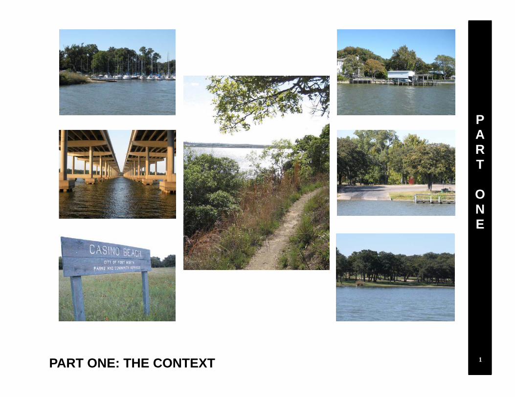
PART ONE: THE CONTEXT
P A R T
O N E
1

P A R T
O N E
Lake Worth History The City of Fort Worth constructed Lake Worth in 1914 as a municipal water supply reservoir and for recreation. Lake Worth is located approximately ten miles northwest of Downtown Fort Worth, Texas and is comprised of more than 3,700 acres (see Map 1). When constructed, the lake was the first man-made reservoir in Texas. From the start, Lake Worth was a center of activity, with people from all over North Texas visiting the lake. During the Depression Era, the Civilian Conservation Corps was active around the lake, and remnants of the Corps’ projects can still be found. Much of the lake’s original circumnavigating access roadway, Meandering Road, still exists today. Small fishing cottages proliferated around Lake Worth on land leased from the City of Fort Worth, which owned the entire lakefront and significant acreage beyond. Casino Beach Park on the north side of the lake became the site of a popular amusement park and a large dance hall. Fort Worth leased the property to investors that operated the park. Casino Beach Park experienced its heyday in the 1930s, and remained active through the 1950s. Over time, some fishing cottages on the lakeshore were replaced by new residential structures. More recently, higher-end homes have been built on City-owned, leased lakeshore property or on lots that the City platted and sold. As years passed, recreational conditions on and around the lake deteriorated, primarily due to siltation and the increasingly shallow lake depths. Accordingly, funding for dredging the lake has consistently been an issue. However, other factors conspired to reduce the importance of Lake Worth as a recreational destination, including the lack of funding to maintain Casino Beach Park. The park structures were demolished in the early 1970s. The demise of the attractions at Casino Beach Park led to a decrease in visitors to Lake Worth, because there was no longer a special recreational destination on the lake. Additionally, other North Texas lakes became increasing popular to boaters and other users.
Aerial view of Casino Beach Park on the north side of Lake Worth in 1930s
Water view of Casino Beach Park on the north side of Lake Worth 2
Nine Mile Bridge, Lake Worth from the Jack White Collection of Historic Fort Worth Photos, University of Texas at Arlington

P A R T
O N E
Map 1: Lake Worth Location
3
Lake Worth History (cont.) The City of Fort Worth still owns many acres of property near the lake (see Map 2). However, beginning in the mid-1990s the City platted and sold more than half of the residential lease property along the shore, primarily to long-time leaseholders. Many of the remaining leaseholders have options to purchase the land from the City when Fort Worth water and sewer infrastructure to serve the properties is made available. There are some areas around the lake where existing residential properties cannot be easily platted due to property configurations that do not comply with zoning or subdivision regulations. The City currently owns a total of 950 acres of non-park property around the lake, and approximately 885 acres of dedicated parkland abutting the lake. The Town of Lakeside, the City of Lake Worth, the City of River Oaks, the City of Sansom Park, and the City of White Settlement developed within close proximity to Lake Worth, but the City of Fort Worth is the only local government that owns property abutting the lake. These jurisdictions are viewed as important stakeholders in determining the future of Lake Worth. For additional Lake Worth history provided by Quentin McGown, please see Appendix A.

P A R T
O N E
Map 2: City of Fort Worth-Owned Property
Source: City of Fort Worth, TAD Parcel Data
4

P A R T
O N E
Citywide Context Fort Worth has been the fastest growing large city of more than 500,000 population in the nation since April 1, 2000. The population of Fort Worth as of January 1, 2010, is estimated to be 736,200 persons. From 2000 to 2010, Fort Worth’s total population increased by 201,506 persons. This represents an average annual increase of approximately 20,150 persons since the 2000 Census, a growth rate of approximately 3.9 percent per year. By 2030, Fort Worth’s population is projected to approach one million. The Far Northwest sector, which includes Lake Worth, is projected by the North Central Texas Council of Governments (NCTCOG) to be one of the fastest growing areas of the city through 2030. The rapid population growth projected to continue in the area around Lake Worth is depicted on the population growth rate map to the right. Darker colors on the map indicated a higher population growth rate. Once dependent on agriculture, oil, and defense, Fort Worth is a major center for industry, technology, distri-bution, and transportation. The State Comptroller pro-jects that job growth in the State of Texas is expected to slow from 2.1 percent annually from 1990 through 2004 to 1.5 percent annually from 2009 through the year 2030. These projections take into account the slowing of the national economy in the face of increasing global compe-tition and tightening labor markets. Major employers near Lake Worth include the Naval Air Station Joint Re-serve Base and Lockheed Martin Aeronautics Company. The map on the next page show the location of new sin-gle-family and multifamily building permits issued throughout the City and near Lake Worth since 2000. The area has experienced significant growth in the last decade. More residential growth is expected near Lake Worth through 2030, as privately-owned agricultural par-cels close to the lake attract developers.
Fort Worth’s population growth is expected to be highest in the northern and western parts of the city. The darker colors indicate increasingly high population growth rates within Transportation Survey Zones, as projected by NCTCOG.
Map 3: Fort Worth Population Growth Rates, 2005-2030
5

P A R T
O N E
Map 4: Residential Building Permits, 2000-2010
Areas near the lake have experienced significant permit activity since 2000. 6
P A R T
O N E
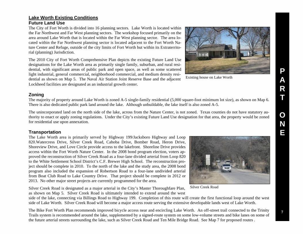
Lake Worth Existing Conditions Future Land Use The City of Fort Worth is divided into 16 planning sectors. Lake Worth is located within the Far Northwest and Far West planning sectors. The workshop focused primarily on the area around Lake Worth that is located within the Far West planning sector. The area lo-cated within the Far Northwest planning sector is located adjacent to the Fort Worth Na-ture Center and Refuge, outside of the city limits of Fort Worth but within its Extraterrito-rial (planning) Jurisdiction.
The 2010 City of Fort Worth Comprehensive Plan depicts the existing Future Land Use designations for the Lake Worth area as primarily single family, suburban, and rural resi-dential, with significant areas of public park and open space, as well as some scattered light industrial, general commercial, neighborhood commercial, and medium density resi-dential as shown on Map 5. The Naval Air Station Joint Reserve Base and the adjacent Lockheed facilities are designated as an industrial growth center. Zoning The majority of property around Lake Worth is zoned A-5 single-family residential (5,000 square-foot minimum lot size), as shown on Map 6. There is also dedicated public park land around the lake. Although unbuildable, the lake itself is also zoned A-5.
The unincorporated land on the north side of the lake, across from the Nature Center, is not zoned. Texas counties do not have statutory au-thority to enact or apply zoning regulations. Under the City’s existing Future Land Use designation for that area, the property would be zoned for residential use upon annexation. Transportation The Lake Worth area is primarily served by Highway 199/Jacksboro Highway and Loop 820.Watercress Drive, Silver Creek Road, Cahoba Drive, Bomber Road, Heron Drive, Shoreview Drive, and Love Circle provide access to the lakefront. Shoreline Drive provides access within the Fort Worth Nature Center. In the 2008 bond program election, voters ap-proved the reconstruction of Silver Creek Road as a four-lane divided arterial from Loop 820 to the White Settlement School District’s C.F. Brewer High School. The reconstruction pro-ject should be complete in 2010. To the north of the lake and the study area, the 2008 bond program also included the expansion of Robertson Road to a four-lane undivided arterial from Boat Club Road to Lake Country Drive. That project should be complete in 2012 or 2013. No other major street projects are currently programmed for the area.
Silver Creek Road is designated as a major arterial in the City’s Master Thoroughfare Plan, as shown on Map 5. Silver Creek Road is ultimately intended to extend around the west side of the lake, connecting via Billings Road to Highway 199. Completion of this route will create the first functional loop around the west side of Lake Worth. Silver Creek Road will become a major access route serving the extensive developable lands west of Lake Worth.
The Bike Fort Worth Plan recommends improved bicycle access near and encircling Lake Worth. An off-street trail connected to the Trinity Trails system is recommended around the lake, supplemented by a signed-route system on some low-volume streets and bike lanes on some of the future arterial streets surrounding the lake, such as Silver Creek Road and Ten Mile Bridge Road. See Map 7 for proposed routes .
Existing house on Lake Worth
Silver Creek Road
7

P A R T
O N E
Map 5: Future Land Use and Master Thoroughfare Plan
Source: City of Fort Worth
8

P A R T
O N E
Source: City of Fort Worth
Map 6: Zoning
9

P A R T
O N E
Map 7: Current Street Pattern and Bike Routes
Source: City of Fort Worth
10

P A R T
O N E
Parks There are 18 individual public parks that surround Lake Worth totaling 913 acres, not in-cluding the 3,621-acre Fort Worth Nature Center that encompasses the lake’s headwaters. The 18 parks currently provide 137 acres of parkland per 1,000 population within the Lake Worth area. In 2030, these parks will provide 102 acres of parkland per 1,000 projected population, which will continue to exceed the national standard. There is an opportunity to connect these existing parks through the implementation of the Lake Worth Vision Plan. Some parks have outdated equipment in need of repair or replacement. The Lake Worth Capital Improvement Implementation Plan recommends upgrading the parks. Environmental Constraints and Opportunities (See Maps 8-13)
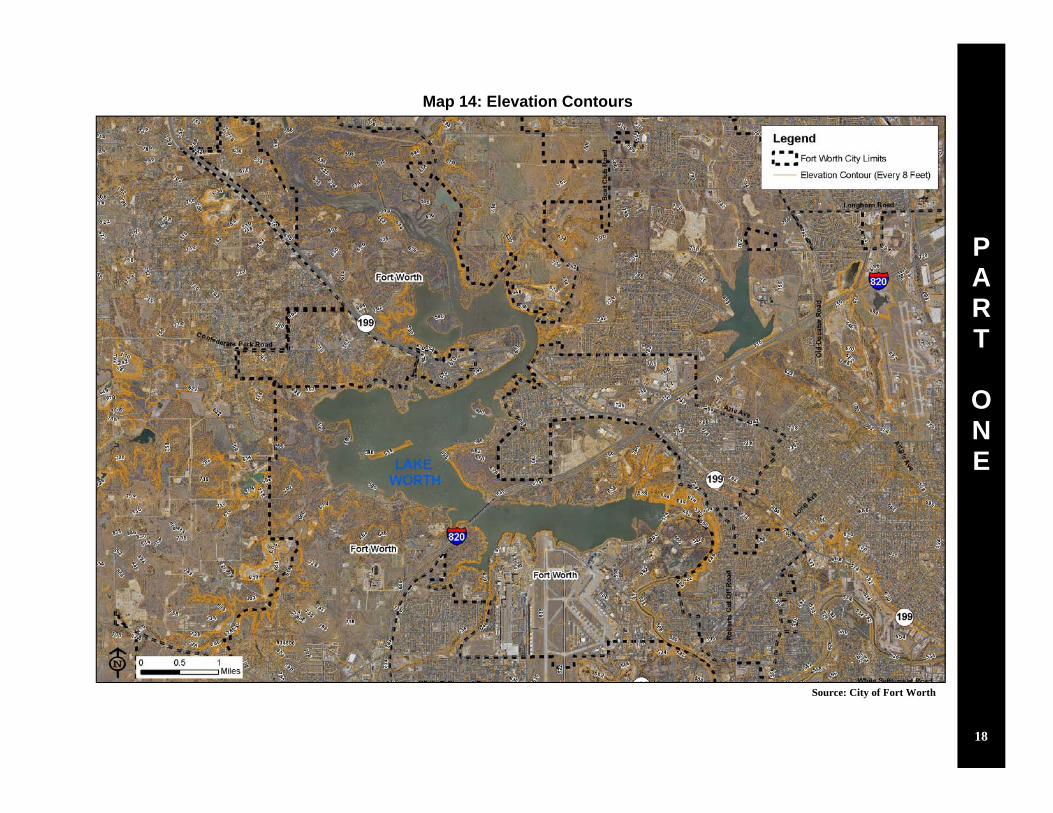
The topography around Lake Worth ranges in elevation from 594 feet at the shoreline to approximately 870 feet at the highest point south of the lake. Receiving waters feeding the lake are contained by relatively flat 100-year floodplain areas characterized by the presence of arable land and soils that are saturated for some parts of the year. Moder-ately steep slopes and bluff areas adjacent to the lake shore provide opportunities for scenic views of the lake.
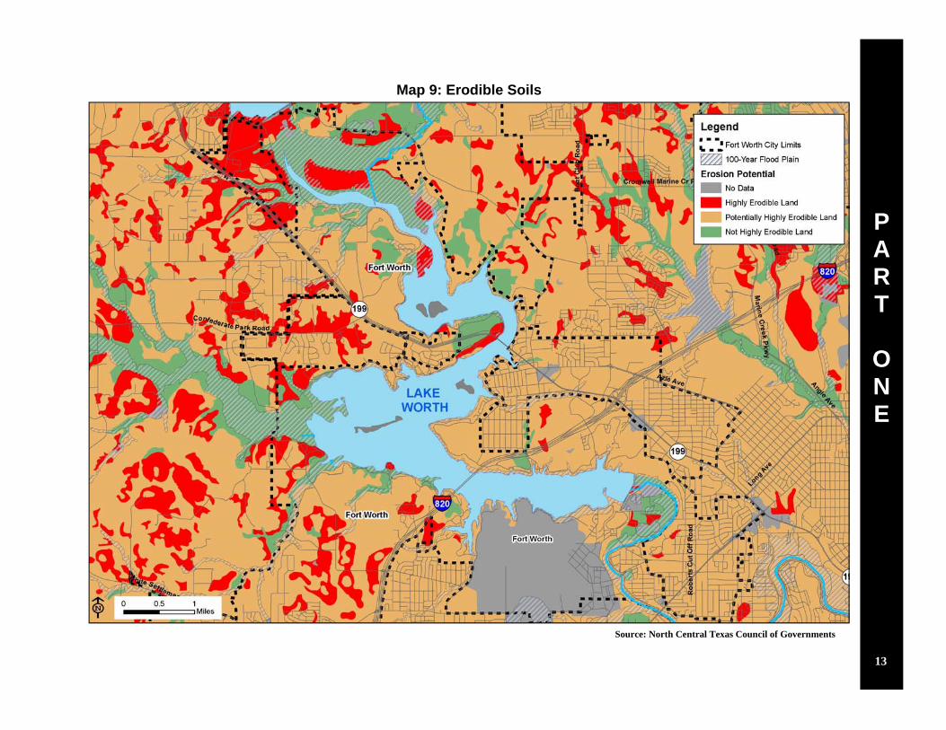
Soils beyond the immediate lake area, especially in the watershed west of Lake Worth, in-clude some highly erodible types. Unmanaged siltation over the years has significantly re-duced the depth of the lake in many areas, resulting in intrusion of wetlands beyond the for-mer lake shore.
There are several existing gas wells and pipelines on private land around Lake Worth that could represent a constraint to future development. Leasing of the City’s Lake Worth properties for development of the underlying Barnett Shale natural gas is expected to provide revenue to fund capital improvements at Lake Worth. This significant, if temporary, revenue stream creates an opportunity to develop Lake Worth as a premier recreation destination to benefit all the citizens of Fort Worth, as well as surrounding communities. To limit negative environmental impacts and preserve opportunities for recreational and other future uses of the land, City staff is working to ensure that best practices are used in the extraction and transportation of natural gas from under the City’s Lake Worth properties.
There are two identified Brownfield sites around Lake Worth. A 43-acre site on Silver Creek Road is a for-mer rifle and pistol club. The City has prepared a proposal to remediate existing lead contamination at the site. Remediation is expected to begin in 2011, following concurrence by the Texas Commission on Envi-ronmental Quality. The second site on Highway 199 has been classified as property that may require some level of environmental remediation due to an automotive repair shop previously operating on the site.
Lake Worth water quality is crucially important to the City, as the lake is a source of raw drinking water for the citizens of Fort Worth. Heightened levels of PCBs have been found in sediment at the east end of the lake, adjacent to the Naval Air Station Joint Reserve Base and the Lockheed Martin aircraft manufacturing facility. Currently, the City’s approach is to not dredge in these areas in order to avoid disturbing this con-taminated sediment, and the possible ramifications of having to mitigate for this impact.
Camp Joy Park on Lake Worth
Gas Drilling Rig
Lake dredging equipment
11

P A R T
O N E
Map 8: Environmental Constraints
Source: City of Fort Worth
12
P A R T
O N E
Map 9: Erodible Soils
Source: North Central Texas Council of Governments
13

P A R T
O N E
Map 10: Prime Farmland
Source: North Central Texas Council of Governments
14

P A R T
O N E
Map 11: Soil Drainage
Source: North Central Texas Council of Governments
15

P A R T
O N E
Map 12: Vegetation Cover
Source: North Central Texas Council of Governments
16

P A R T
O N E
Map 13: Water Features
Source: City of Fort Worth, North Central Texas Council of Governments
17
P A R T
O N E
Map 14: Elevation Contours
Source: City of Fort Worth
18
P A R T
O N E
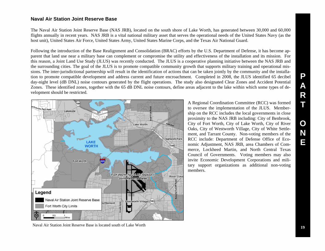
Naval Air Station Joint Reserve Base The Naval Air Station Joint Reserve Base (NAS JRB), located on the south shore of Lake Worth, has generated between 30,000 and 60,000 flights annually in recent years. NAS JRB is a vital national military asset that serves the operational needs of the United States Navy (as the host unit), United States Air Force, United States Army, United States Marine Corps, and the Texas Air National Guard. Following the introduction of the Base Realignment and Consolidation (BRAC) efforts by the U.S. Department of Defense, it has become ap-parent that land use near a military base can complement or compromise the utility and effectiveness of the installation and its mission. For this reason, a Joint Land Use Study (JLUS) was recently conducted. The JLUS is a cooperative planning initiative between the NAS JRB and the surrounding cities. The goal of the JLUS is to promote compatible community growth that supports military training and operational mis-sions. The inter-jurisdictional partnership will result in the identification of actions that can be taken jointly by the community and the installa-tion to promote compatible development and address current and future encroachment. Completed in 2008, the JLUS identified 65 decibel day-night level (dB DNL) noise contours generated by the flight operations. The study also designated Clear Zones and Accident Potential Zones. These identified zones, together with the 65 dB DNL noise contours, define areas adjacent to the lake within which some types of de-velopment should be restricted.
A Regional Coordination Committee (RCC) was formed to oversee the implementation of the JLUS. Member-ship on the RCC includes the local governments in close proximity to the NAS JRB including: City of Benbrook, City of Fort Worth, City of Lake Worth, City of River Oaks, City of Westworth Village, City of White Settle-ment, and Tarrant County. Non-voting members of the RCC include: Department of Defense Office of Eco-nomic Adjustment, NAS JRB, area Chambers of Com-merce, Lockheed Martin, and North Central Texas Council of Governments. Voting members may also invite Economic Development Corporations and mili-tary support organizations as additional non-voting members.
Naval Air Station Joint Reserve Base is located south of Lake Worth 19

P A R T
O N E
Map 15: NAS JRB Accident Potential Zones and Noise Contours
Source: City of Fort Worth
20