Paleoseismology and slip rate of the Conway Segment of the ...€¦ · Audru, 1999). Important...
22
1. Introduction The Hope Fault is a 230 km long system of dextral-slip faults at the southwestern edge of the Marlborough Fault Zone (MFZ), that can be traced from the Alpine Fault to the northeast coast of South Island near Kaikoura (Freund, 1119 ANNALS OF GEOPHYSICS, VOL. 46, N. 5, October 2003 Key words Hope Fault – Kaikoura – Conway Segment – New Zealand – paleoseismicity – neotec- tonics – slip rate – recurrence – NZMS 260 sheet 031 Mailing address: Dr. Robert Langridge, Institute of Ge- ological and Nuclear Sciences, P.O. Box 30-368, Lower Hutt, New Zealand; e-mail: [email protected] Paleoseismology and slip rate of the Conway Segment of the Hope Fault at Greenburn Stream, South Island, New Zealand Robert Langridge ( 1 ), Jocelyn Campbell ( 2 ), Nigel Hill ( 1 ), Verne Pere ( 2 ), James Pope ( 2 ), Jarg Pettinga ( 2 ), Beatriz Estrada ( 2 ) and Kelvin Berryman ( 1 ) ( 1 ) Institute of Geological and Nuclear Sciences, Lower Hutt, New Zealand ( 2 ) Department of Geological Sciences, University of Canterbury, Christchurch, New Zealand Abstract The Conway Segment of the dextral-slip Hope Fault is one of the fastest slipping fault segments along New Zealand’s plate boundary, but has not ruptured co-seismically in the historic period and little paleoseismic data exist to constrain its large earthquake record. Two paleoseismic trenches were opened adjacent to Greenburn Stream near Kaikoura for the 2001 ILP Paleoseismology Conference. Both trenches were excavated into deposits ponded against an uphill-facing shut- ter scarp. Trench 1, dug through a cobbly soil and surface deposit was dominated by a thick fan/fluvial sequence that was radiocarbon dated at 4409 ± 60 C 14 years BP (4844-5288 cal years BP) at the base of the trench. This trench exhibited evidence of complex deformation from many paleoseismic events. The most recent earthquakes are difficult to constrain due to a lack of cover stratigraphy on the fan deposits. However,the modern soil appears to be faulted and is covered by cobbles with a weathering rind-derived age of 220 ± 60 years. Trench 2, dug 50 m to the west has an expanded sequence of the younger cover deposits. Paleoseismic event horizons have been recognised from the combined evidence of upward- terminating faults, offset and mismatched units, a sandblow deposit, and abrupt landscape change shown by the burial of paleosol surfaces that form the event horizons. Two paleosols underlying the modern soil are clearly faulted by two sep- arate rupture events. A dome of sand interpreted as a liquefaction sandblow deposit overlies the lower paleosol (event horizon). Both paleosols are overlain by metre-thick debris deposits, interpreted as earthquake-induced rock avalanches that cascaded off the hillslope following Mw 7 + events. Four radiocarbon dates place some constraints on the timing of the three recent surface-rupturing events. The youngest and lowest date is 548 ± 60 C 14 years BP (504-656 cal years BP) and occurs below the lower paleosol. It constrains the maximum duration of time in which the last 2 earthquake events occurred to be 545 years (1295-1840 A.D.). This is consistent with the average Recurrence Interval (RI) of 180-310 years that we determine using two independent paths. The soil record indicates that each event is separated by a significant peri- od of time, comparable to the calculated RI. The most recent event is constrained between ca. 1780 A.D. ± 60 years, tak- ing into account the dates from these trenches, a weathering rind age, and from stratigraphic correlation at the site. Event III probably occurred before 1220 A.D. A maximum dextral slip rate of 23 ± 4 mm/yr is calculated from the minimum fan age and the offset/deflection of a stream channel along the shutter ridge. In concert with the estimate of single event displacement (5-6 m), these results show that the Conway Segment of the Hope Fault is fast-slipping and has ruptured regularly as a result of large earthquakes prior to the European colonisation of New Zealand.
Transcript of Paleoseismology and slip rate of the Conway Segment of the ...€¦ · Audru, 1999). Important...

1. Introduction
The Hope Fault is a 230 km long system ofdextral-slip faults at the southwestern edge of theMarlborough Fault Zone (MFZ), that can betraced from the Alpine Fault to the northeastcoast of South Island near Kaikoura (Freund,
1119
ANNALS OF GEOPHYSICS, VOL. 46, N. 5, October 2003
Key words Hope Fault – Kaikoura – ConwaySegment – New Zealand – paleoseismicity – neotec-tonics – slip rate – recurrence – NZMS 260 sheet 031
Mailing address: Dr. Robert Langridge, Institute of Ge-ological and Nuclear Sciences, P.O. Box 30-368, LowerHutt, New Zealand; e-mail: [email protected]
Paleoseismology and slip rate of theConway Segment of the Hope Fault at Greenburn Stream, South Island,
New Zealand
Robert Langridge (1), Jocelyn Campbell (2), Nigel Hill (1), Verne Pere (2), James Pope (2), Jarg Pettinga (2),Beatriz Estrada (2) and Kelvin Berryman (1)
(1) Institute of Geological and Nuclear Sciences, Lower Hutt, New Zealand(2) Department of Geological Sciences, University of Canterbury, Christchurch, New Zealand
AbstractThe Conway Segment of the dextral-slip Hope Fault is one of the fastest slipping fault segments along New Zealand’splate boundary, but has not ruptured co-seismically in the historic period and little paleoseismic data exist to constrain itslarge earthquake record. Two paleoseismic trenches were opened adjacent to Greenburn Stream near Kaikoura for the2001 ILP Paleoseismology Conference. Both trenches were excavated into deposits ponded against an uphill-facing shut-ter scarp. Trench 1, dug through a cobbly soil and surface deposit was dominated by a thick fan/fluvial sequence that wasradiocarbon dated at 4409 ± 60 C14 years BP (4844-5288 cal years BP) at the base of the trench. This trench exhibitedevidence of complex deformation from many paleoseismic events. The most recent earthquakes are difficult to constraindue to a lack of cover stratigraphy on the fan deposits. However, the modern soil appears to be faulted and is covered bycobbles with a weathering rind-derived age of 220 ± 60 years. Trench 2, dug 50 m to the west has an expanded sequenceof the younger cover deposits. Paleoseismic event horizons have been recognised from the combined evidence of upward-terminating faults, offset and mismatched units, a sandblow deposit, and abrupt landscape change shown by the burial ofpaleosol surfaces that form the event horizons. Two paleosols underlying the modern soil are clearly faulted by two sep-arate rupture events. A dome of sand interpreted as a liquefaction sandblow deposit overlies the lower paleosol (eventhorizon). Both paleosols are overlain by metre-thick debris deposits, interpreted as earthquake-induced rock avalanchesthat cascaded off the hillslope following Mw 7 + events. Four radiocarbon dates place some constraints on the timing ofthe three recent surface-rupturing events. The youngest and lowest date is 548 ± 60 C14 years BP (504-656 cal years BP)and occurs below the lower paleosol. It constrains the maximum duration of time in which the last 2 earthquake eventsoccurred to be 545 years (1295-1840 A.D.). This is consistent with the average Recurrence Interval (RI) of 180-310 yearsthat we determine using two independent paths. The soil record indicates that each event is separated by a significant peri-od of time, comparable to the calculated RI. The most recent event is constrained between ca. 1780 A.D. ± 60 years, tak-ing into account the dates from these trenches, a weathering rind age, and from stratigraphic correlation at the site. EventIII probably occurred before 1220 A.D. A maximum dextral slip rate of 23 ± 4 mm/yr is calculated from the minimumfan age and the offset/deflection of a stream channel along the shutter ridge. In concert with the estimate of single eventdisplacement (5-6 m), these results show that the Conway Segment of the Hope Fault is fast-slipping and has rupturedregularly as a result of large earthquakes prior to the European colonisation of New Zealand.

1971). Deformation across the MFZ accommo-dates the oblique convergence of the Australian-Pacific plate margin in Northern South Island(fig. 1), marking the transition from the west-facing Hikurangi subduction margin to the east-
facing Alpine Fault and Puysegur subductionmargin (Berryman et al., 1992; Holt and Haines,1995). The MFZ comprises four main strike-slipfaults with subsidiary oblique-slip faults (e.g.Kekerengu Fault) occurring at its northeastern
1120
Robert Langridge, Jocelyn Campbell, Nigel Hill, Verne Pere, James Pope, Jarg Pettinga, Beatriz Estrada and Kelvin Berryman
40 So
35 So
170 Eo 175 Eo180 Eo
Australian Plate
Pacific Plate
Hik
urang
i Tro
ugh
Wairau Fault
Awatere FaultWaihopai F.
Kakapo F.
NorthIsland
MFZ
47
34
39
37
Puys
egur
Tren
ch
Tasman Sea
PacificOcean
Nelson
Blenheim
Kaikoura
Hokitika
SouthIsland
N
Christchurch
Clarence F.1848
Alpine Fault
Kelly F. 1929Poulter F.
1717 ?1888
0 50km
Figure 2
Alpine Fault
SouthIsland
Hope Fault
Kekerengu F.
1 2
34 5
HF
42 So
172 Eo
Fig. 1. Location of the Hope Fault in the Marlborough Fault Zone (MFZ) (bold lines), Northern South Island.The Hope Fault System is shown boldest and fault segments are numbered in italics (1 - Kelly Fault; 2 - Hurunuisection; 3 - Hope River Segment; 4 - Conway Segment, and 5 - Seaward Segment), their boundaries beingmarked by open circles. Surface fault ruptures, e.g., 1888 North Canterbury earthquake, are shown as grey bands.Inset: New Zealand plate boundary including Alpine Fault, MFZ and Hikurangi Trough. Nuvel-1 directions(arrows) and plate rates relative to Australian Plate (in mm/yr) after DeMets et al. (1994).
end (Van Dissen and Yeats, 1991). Those fourfaults account for a large proportion of the plateboundary motion at their location, where almostcomplete locking occurs between the subducting(Pacific) plate and overriding (Australian) plate.From northwest to southeast, these faults are the Wairau, Awatere, Clarence, and Hope Faults(Lensen, 1968; Campbell, 1973; Kieckhefer,1979; Yeats and Berryman, 1987; Van Dissen,1989; McCalpin, 1996). These faults generallyhave higher slip rates as one progresses south-east across the MFZ. The eastern Hope Fault(Conway Segment) has the highest Holoceneslip rate (Bull, 1991; McMorran, 1991; Knuepfer,1992; Pope, 1994) and geodetic rate (Bibby,1976; Bourne et al., 1998) for faults within theMFZ. However, the Conway Segment has only amodest level of seismicity and no record of sur-face-rupturing earthquakes within New Zealand’sshort historic period (Anderson et al., 1993;Reyners and Cowan, 1993; Anderson and Webb,1994). Indeed, within the MFZ since 1840 A.D.only the eastern Awatere Fault (1848) and centralHope Fault (Hope River Segment - 1888) haveruptured co-seismically (McKay, 1890; Cowan,1991; Grapes et al., 1998). In addition, the pre-historic (paleoearthquake) record of the ConwaySegment of the Hope Fault is not well under-stood at this time.
The 2001 ILP Conference on Paleoseismo-logy offered us the unique opportunity to studyand present results from our second fastest slip-ping onland fault in an international forum.Data from two new trenches excavated, loggedand dated in conjunction with the conferenceprogram allow us to estimate: i) the age of thethree most recent earthquake events and theirbearing on previous studies, and ii) a new dex-tral slip rate for the Conway Segment of theHope Fault from the Greenburn Stream site.
2. The Hope Fault and Conway Segment
The Hope Fault has been traced from itsbranching junction with the Alpine Fault southof Hokitika (fig. 1), northeast to the coast northof Kaikoura (Freund, 1971; Van Dissen, 1989)and into the offshore shelf region (Barnes andAudru, 1999). Important early onshore studies
relate to the reconnaissance of the 1888 NorthCanterbury earthquake, recognition of strike-slip displacement (McKay, 1890), and subse-quent mapping of the fault system in its entire-ty (Freund, 1971; Hardy and Wellman, 1984).The Hope Fault has been the subject of numer-ous recent neotectonic and structural stud-ies, many emanating from the University ofCanterbury (e.g., Cowan, 1989, 1990; VanDissen, 1989; Bull, 1991; McMorran, 1991;Cowan and McGlone, 1991; Pope, 1994; Woodet al., 1994; Simpson, 1995; Eusden et al.,2000).
Based on tectonic geomorphology and therecord of the 1888 event, the Hope Fault can bedivided into a number of geometrically-definedsegments or sections (fig. 1), namely the KellyFault, and the Hurunui, Hope River, Conway,and Seaward segments (see Van Dissen, 1989;Cowan and McGlone, 1991; Simpson, 1995;Pettinga et al., 1998, 2001; Langridge, 2003).This paper focuses on the Conway Segment of the Hope Fault, a 70 km section from theKowhai River to the Hanmer Basin (fig. 2),emphasising results from a trench site adjacentto Greenburn Stream. East of the KowhaiRiver, the Conway Segment splays into a num-ber of dextral and transpressive features,including the Fyffe Fault, Kowhai Fault andJordan Thrust (Van Dissen and Yeats, 1991)(fig. 3). At its western end the Conway Se-gment begins from the Hanmer Basin, an exten-sional step-over or pull-apart in the Hope FaultSystem, which is also the northeastern termina-tion of the 1888 surface faulting event (McKay,1890; Freund, 1971; Cowan, 1991; Wood et al.,1994).
The Conway Segment is characterised by arelatively continuous linear trace striking aboutN73°E and has a slip rate of 18-35 mm/yr basedon offset alluvial features (Freund, 1971; VanDissen, 1989; Bull, 1991; McMorran, 1991;Knuepfer, 1992; Pope, 1994). The ConwaySegment bounds the southern rangefront of theSeaward Kaikoura, Hawk and Amuri ranges(figs. 2, 3). Oblique compression across theHope Fault System is responsible for > 2 km oftopography observed in these ranges (fig. 3).Where exposed, the fault dips steeply to theNW at 70° (Van Dissen, 1989; McMorran,
1121
Paleoseismology and slip rate of the Conway Segment of the Hope Fault at Greenburn Stream, South Island, New Zealand

1122
Robert Langridge, Jocelyn Campbell, Nigel Hill, Verne Pere, James Pope, Jarg Pettinga, Beatriz Estrada and Kelvin Berryman
Awatere Fault
Hope
FaultCulverdenBasin
Clarence Fault
PacificOcean
Conway Segment
Hope
Fault
Clarence
Fault
Figure 3
HanmerBasin
0 20 km10
Kaikoura
N
H
K
Fig. 2. Digital Terrain Model of the southeast MFZ, illuminated from the southeast. Major active faults are shownby arrows and delineated by the rangefronts and valleys. In the west, the Hope Fault System consists of ENE-trend-ing strike-slip sections separated by the Hanmer Basin extensional stepover, and passes east into oblique-contractionalfaults near the coast. The Conway Segment is shown between the Hanmer Basin and Kowhai River (K), marked bytwo white circles. The Greenburn Stream site is shown by a white arrow; Hossack Saddle (H).
Fig. 3. Structure of the eastern Hope Fault and location of the Greenburn Stream trench site (modified afterCampbell, 2001). The Conway Segment passes east into the Seaward Segment east of Kowhai River, and the Mt.Fyffe and Kowhai Faults. The trench site is adjacent to Greenburn Stream.
0 5 km
Mt. Manakau2610 m2151 m
Jord
an Thrust
Halfmoon Bay
Pacific Ocean
U
UU
Syncline
PuhipuhiFault
Seaward Kaikoura Range
60
Mt. Fyffe1602 m
70
8485
1873 m
Hope Fault(Seaward Segment)
Hawk Range
Kowhai
U
Greenburn Stream
trench site U
U
LEGEND85
1568 m
947 m
1444 m
Hapuku
River
48
28
Kaikoura
Kow
hai
River
Kahutara
River
Fyffe Fault
N
Active thrust- teeth toward upthrown side
Active strike-slip fault- U, upthrown side and dip
Syncline
Conway Downs
Hope Fault
Charwell
River
Conway
River
Clarence Reserve
Amuri Range
Sawyers Creek
(Conway Segment)

1991). Although no large earthquakes have ruptured the Conway Segment historically (last
160 years), lichenometric studies suggest thatthe Conway Segment was recently ruptured twi-ce by large seismic events (Mw 7 +) in 1768 A.D.and in the 1830’s, the decade preceding the adventof initial European colonisation (Bull, 1998; Bulland Brandon, 1998).
Paleoseismic studies have been conductedalong this segment of the Hope Fault by McMor-ran (1991) and by Pope (1994) near GreenburnStream. McMorran was able to demonstrate aHolocene slip rate of 18 ± 8 mm/yr but could notdetermine the age of any paleo-earthquakeevents. Pope (1994) trenched a small sag pond atClarence Reserve (fig. 3) and was able to recog-nise and date three paleoearthquake events. Noneof these events are believed young enough to rep-resent the most recent surface-rupturing event.Therefore, considerable scope still remained toundertake paleoseismic and slip rate studiesalong the Conway Segment.
3. The Greenburn Stream site
Near Greenburn Stream the Hope Fault hasa clear geomorphic trace in aerial photographsand on the ground (fig. 4). The fault scarp atGreenburn Stream forms a linear trace, charac-terised mainly by an uphill-facing scarp locatednear the base of the southern, faceted range-front of the Hawk Range. Several deeply-incised southward draining streams cross thefault trace (fig. 3). Two paleoseismic trencheswere opened at a site ~ 700 m upstream fromthe Highway 70 bridge over Greenburn Streamadjacent to a tributary stream, here informallyreferred to as «Urquhart Stream» (NZMS 260O31/423678), shown in fig. 5. The trencheswere excavated across a ridge or «shutterscarp», that has been dextrally displaced by thefault. The scarp is cored by sheared basementgreywacke sandstones (Torlesse Group) thatformerly created a barrier to stream flow. A fanaggraded against this ridge and it is clear that an
1123
Paleoseismology and slip rate of the Conway Segment of the Hope Fault at Greenburn Stream, South Island, New Zealand
shutter scarp
fault trace
debris fan lobe
Trench 1
«Urquhart» Stream Greenburn
valley
ponded fan
Fig. 4. The Greenburn Stream site with vehicle for scale. View to the east shows Trench 1 excavated throughthe shutter scarp and into the ponded alluvial fan surface. The site is elevated above modern «Urquhart Stream»and Greenburn valley. Drainage at the site was from left to right. Recent incision by Urquhart Stream has aban-doned this surface.

older channel was dextrally deflected around thewestern end of the ridge. This fan and channelwere later abandoned when Urquhart Streamincised through the bedrock shutter ridge.Scattered, angular blocks of greywacke thatremain on the top surface of the abandoned fanyield a weathering rind age of 220 years (Pope,1994). Trench 1 was dug through the scarp andfan surface, while Trench 2 was excavated 50 mfurther to the west (fig. 5). Immediately north ofthe fault at Trench 2 is a small debris fan and scarthat had potential as a datable, event-capping andshaking-induced deposit.
In detail, the shutter scarp has a sinuous,almost en échelon stepping scarp morphology.The style of the scarp (tectonic geomorphology)is influenced by the transpressive nature of theConway Segment (Campbell, 2001). The faultdips 60-70° to the north and the ranges have anup-to-the-north sense of topography, as does theuphill-facing shutter scarp. The Torlesse bedrockcoring the shutter ridge is highly sheared withoverthrust relations in exposures along UrquhartStream, and a 15 cm wide gouge (pug) zone, cor-
responding to the Hope Fault, is also exposed in itschannel.
A series of dextral displacement estimateswere measured from geomorphic features by Pope(1994) between Greenburn and Sawyers Creek.These measurements range from 3.4 to 31 m dex-tral displacement and reflect the likelihood of mul-tiple events accumulating offset on older features.The average of nine Single Event Displacement(SED) measures in this area is 5-6 m (Pope, 1994).Three displacement measures were made adjacentto the trenches within the modern, incised banksof Urquhart Stream. These values are 3.4,4.9 ± 0.2, and 10.4 ± 0.2 m. Pope concluded thatthe higher value was derived from two displace-ment events, while the lower value was consideredto be a minimum due to erosional trimming of thestream bank at the fault.
4. Trench 1
Trench 1 (T1) was located 10 m from the west bank of Urquhart Stream, excavated
1124
Robert Langridge, Jocelyn Campbell, Nigel Hill, Verne Pere, James Pope, Jarg Pettinga, Beatriz Estrada and Kelvin Berryman
N0 50 m
D~10.4 m
D~4.9 m
P
P*Shutter Scarp
Fault trace
Abandoned Outlet
Debris Fan
Trench 2 Trench 1
D~3.4 m
«Urquhart» Stream
Alluvial Fan
hillslope in bedrock
hillslope in bedrock
Fig. 5. Simplified geomorphic sketch of the trench site (modified after Pope, 1994). Modern incised UrquhartStream crosses the fault but was formerly deflected dextrally and drained through the abandoned outlet. The faultdeflection P to P* is marked by stars. Inferred measured single event dextral (D) displacement values (in metres)are shown. Trench 2 clips deposits of the landslide lobe at its northern end as shown on log.
to a length of 17 m and benched (fig. 4). Thescarp height there, relative to the fan surface,is 1.6 m and the total exposure from thehighest point on the shutter scarp to lowestpoint in the trench is 5 m. The site was cho-sen with several hypotheses about the geomor-phology and subsurface materials in mind, in-cluding: i) the presence of a thick fan aggrada-tion sequence deposited against the shutterridge; ii) post-fan abandonment deposits againstthe scarp, including the surficial cobble deposit,that may contain charcoal and evidence for themost recent earthquakes, and iii) a cross-section-al view through the scarp at the location of an enéchelon step, that may give insights into thestructure of such features. Only the east wall ofthe trench was logged at the time of the ILP con-ference and is presented in detail for this paper.However, the west wall of T1 was mapped inJanuary 2002. The west wall comprised similarunits to the east wall, though the thicknesseswere expanded, and therefore the sequence didnot extend as far back in time.
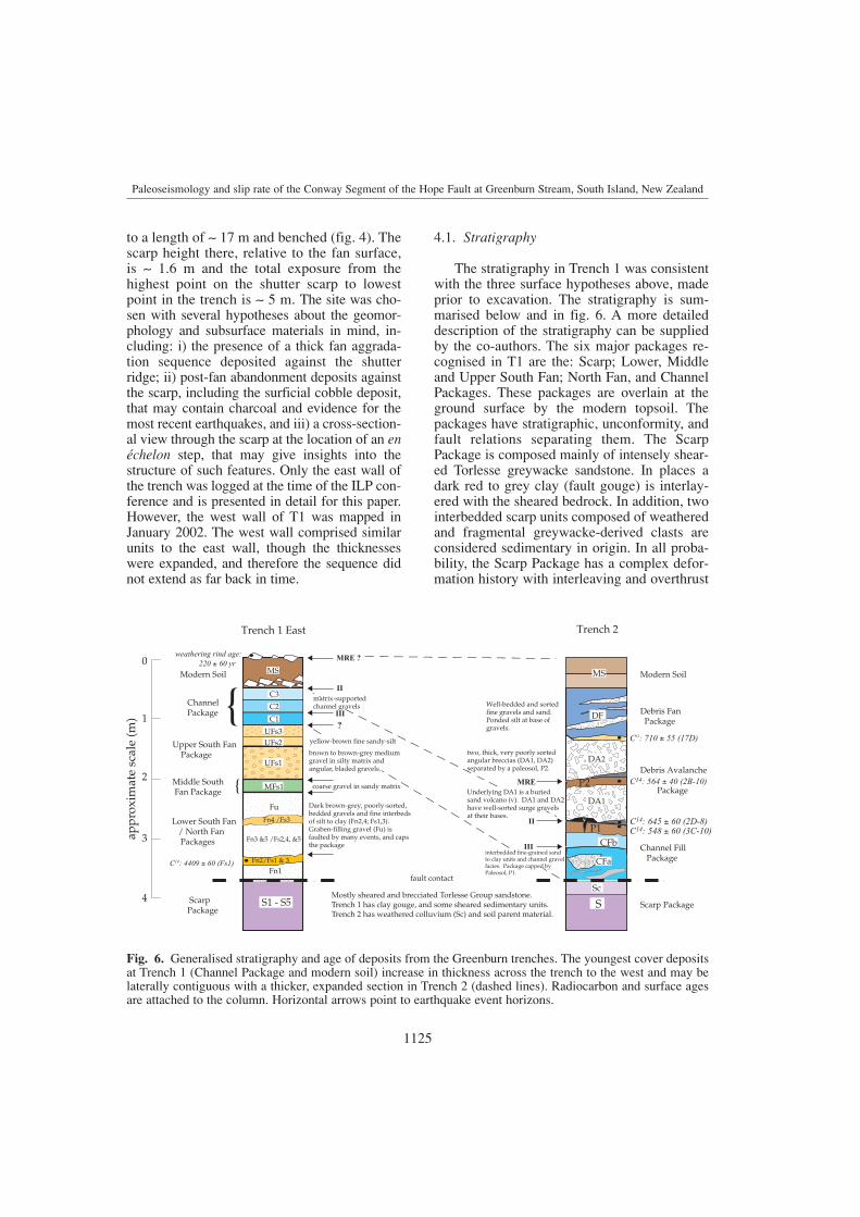
4.1. Stratigraphy
The stratigraphy in Trench 1 was consistentwith the three surface hypotheses above, madeprior to excavation. The stratigraphy is sum-marised below and in fig. 6. A more detaileddescription of the stratigraphy can be suppliedby the co-authors. The six major packages re-cognised in T1 are the: Scarp; Lower, Middleand Upper South Fan; North Fan, and ChannelPackages. These packages are overlain at theground surface by the modern topsoil. Thepackages have stratigraphic, unconformity, andfault relations separating them. The ScarpPackage is composed mainly of intensely shear-ed Torlesse greywacke sandstone. In places adark red to grey clay (fault gouge) is interlay-ered with the sheared bedrock. In addition, twointerbedded scarp units composed of weatheredand fragmental greywacke-derived clasts areconsidered sedimentary in origin. In all proba-bility, the Scarp Package has a complex defor-mation history with interleaving and overthrust
1125
Paleoseismology and slip rate of the Conway Segment of the Hope Fault at Greenburn Stream, South Island, New Zealand
Scarp Package
Debris Avalanche
Package
Channel Fill Package
C14: 710 ± 55 (17D)
CFb
ScarpPackage
Modern Soil
ChannelPackage
Upper South Fan Package
Middle South Fan Package
Lower South Fan / North Fan Packages
Trench 1 East Trench 2
Mostly sheared and brecciated Torlesse Group sandstone. Trench 1 has clay gouge, and some sheared sedimentary units.Trench 2 has weathered colluvium (Sc) and soil parent material.
Fn4 /Fs3
C14: 4409 ± 60 (Fs1)
weathering rind age: 220 ± 60 yr
S1 - S5
Fn1
Fn3 &5 /Fs2,4, &5
Fu
C3
C1
C2
fault contact
two, thick, very poorly sorted angular breccias (DA1, DA2)separated by a paleosol, P2.
Underlying DA1 is a buriedsand volcano (v). DA1 and DA2 have well-sorted surge gravels at their bases.
interbedded fine-grained sand to clay units and channel gravelfacies. Package capped by Paleosol, P1.
SSc
MSMS
MRE
II
III
II
III
MRE ?
MFs1
UFs1
UFs2UFs3
Modern Soil
Debris Fan Package
P1
P2
Dark brown-grey, poorly-sorted, bedded gravels and fine interbedsof silt to clay (Fn2,4; Fs1,3).Graben-filling gravel (Fu) is faulted by many events, and caps the package
brown to brown-grey mediumgravel in silty matrix and angular, bladed gravels.
matrix-supportedchannel gravels
C14: 645 ± 60 (2D-8)C14: 548 ± 60 (3C-10)
C14: 564 ± 40 (2B-10)
Well-bedded and sortedfine gravels and sand.Ponded silt at base ofgravels.
DA1
DA2
2
1
3
4
0
appr
oxim
ate
scal
e (m
) DF
Fn2/Fs1 & 3
coarse gravel in sandy matrix
yellow-brown fine sandy-silt
CFa
v
{
{
?
Fig. 6. Generalised stratigraphy and age of deposits from the Greenburn trenches. The youngest cover depositsat Trench 1 (Channel Package and modern soil) increase in thickness across the trench to the west and may belaterally contiguous with a thicker, expanded section in Trench 2 (dashed lines). Radiocarbon and surface agesare attached to the column. Horizontal arrows point to earthquake event horizons.

1126
Robert Langridge, Jocelyn Campbell, Nigel Hill, Verne Pere, James Pope, Jarg Pettinga, Beatriz Estrada and Kelvin Berryman
No
rth
So
uth
1D
1112
1517
1819
2220
2116
1F-1
8(4
309
0±
990
)
1C
1314
1C1B
rr
r
r
rip
-up
of
pal
eoso
l rr
rr
1E
rr
r
r
r
rock
cla
sts
larg
e en
ough
to m
ap
3C-1
0(5
48±
60)
2B-1
0(5
64±
40)
1C2
34
5
0
16
8
79
10
r
r
rr
r
r
2CLBU
B
2B
r
r
r
r
r
r
r
r
r
r
r
r
P1
0 21 3 4 5
Sc
1G
r
benc
h
bench
sand
01234
A
EG
RE
EN
BU
RN
ST
RE
AM
TR
EN
CH
1 -
Eas
t Wal
l
bench
No
rth
So
uth
m
Fn1
Fn2
S5
coar
se g
rave
l
brow
n gr
avel
defo
rmed
grav
el
D
F
G
Fs1
(440
9± 6
0)
C
B
dar
k br
own
coar
se g
rave
l
silt
unso
rted
bro
wn
sand
y gr
avel
fine
fri
able
chip
gra
vel
Fn4
pebb
lysi
lty
sand
coar
segr
avel
15
43
21
01
71
49
87
61
211
13
16
15
18
shut
ter
sca
rpH
I
Nor
th F
an
grab
en
S1S2S4
S3a
S1
S3b
S1
S3b
Fs5 F
s4
Fs3
Fs2
Fs1
Fn4
Fn3
S3a
Fu
Fu
Fu
Fn5
Fn3
Fn5
Fn4
Fn5
C1C
2C
3M
SM
S
MS
MS
UF
s3
UF
s2U
Fs1
MF
s1
m
m
Sou
th F
an
J
TR
EN
CH
2 -
Wes
t Wal
l (re
vers
ed)
AB
DE
FG
H
C 083o
rr
rr
rr
r
rr
collu
viu
m
r
2G
2C
r
r
A
B1
4
S
S
S
CFb
CFa
MS
MS
P1
P2
P2
DA
1
DA
2
DA
1
17D
(71
0± 5
5)D
F
DF
r
r
Rad
ioca
rbon
sam
ple
loca
tions
17D
S4
3F3D
2D
2D
2D-8
(645
± 6
0)
r
rvr
r
rr
r
r
r
rr
r
r
r
ba
Fig
. 7a
,b.
Col
ored
geo
logi
c lo
g of
(a)
eas
t wal
l of T
renc
h 1
(T1)
and
(b)
wes
t wal
l of T
renc
h 2
(T2-
reve
rsed
for
com
pari
son)
with
bro
ad s
trat
igra
phic
subd
ivis
ions
sho
wn,
as d
etai
led
in f
ig. 6
. The
shu
tter
scar
p co
nsis
ts o
f in
tens
ely
shea
red
Torl
esse
bed
rock
,col
luvi
al d
epos
its (
in p
urpl
e) a
nd s
oil.
The
pond
ed a
lluvi
al f
an s
eque
nce
of T
1 is
fau
lted
by m
ultip
le e
arth
quak
e ev
ents
bet
wee
n an
d w
ithin
pac
kage
s. I
n T
2,th
ree
dist
inct
soi
ls (
in b
row
n) r
ep-
rese
ntin
g pr
e-ru
ptur
e gr
ound
sur
face
s co
nver
ge t
owar
d th
e sc
arp,
whe
re P
1an
d P 2
are
faul
ted.
The
se s
oils
ove
rlie
allu
vial
and
deb
ris
aval
anch
ede
posi
ts. R
adio
carb
on s
ampl
e si
tes
and
ages
are
sho
wn
by g
reen
sta
rs.

1127
Paleoseismology and slip rate of the Conway Segment of the Hope Fault at Greenburn Stream, South Island, New Zealand
relations likely. All other packages onlap or arefaulted against the Scarp Package.
The South Fan refers to three packages ofdistinctive deposits between the scarp andintense graben faulting, all being separated byunconformities. The Lower South Fan Package(Fs) comprises five units dominated by poorlysorted, bedded gravels with angular to subangu-lar sandstone clasts in a clay matrix. Bands ofweakly indurated fine sand to clay act as mark-er horizons separating distinct gravel units.Fine-grained charcoal was located in several ofthese fine units. A single radiocarbon date froma sandy silt bed (Fs1) near the base of the trench(fig. 7a) yielded an age of 4409 ± 60 C14 yearsBP (table I). We use this age below to developa slip rate and recurrence data from this site.
The Middle South Fan Package consists ofonly one unit (MFs1), an unconformity-boundcoarse gravel deposit. The Upper South FanPackage consists of three units. The main bodyof this package consists of coarse, brown grav-el within a silty matrix. The capping unit is adark brown-grey gravel of angular bladed clastsof up to 10 cm diameter in a sandy matrix. Thisunit has accumulated ~ 30 cm of apparent ver-tical displacement across it against the scarpdeposits during recent displacement events.
The North Fan Package (Fn) comprises sixunits. The exposed lower half of this packageconsists of dark brown-grey, poorly sorted grey-wacke gravel (Fn1). Above this are interbeddedgravel and silt-clay units. These units are cappedby and faulted against undifferentiated, de-formed (Fu) gravels that fill a graben-shaped fea-
ture in the middle of this trench. There is a gen-eral correspondence between the North Fan andLower South Fan packages in this trench. How-ever, it is not possible to directly match gravel orsilt facies from north to south along the trenchwall. The South and North Fan Packages are con-sistent with fan aggradation related to the formercourse of Urquhart Stream.
The uppermost package is named theChannel Package (C). It consists of three units(C1-C3) of channel gravels that fine upwardsoverall, i.e. they show evidence for decreasingstream power up-section. The channel depositsappear to correspond to a scarp-parallel drainagesystem. Package C merges upward into the mod-ern topsoil (MS), which has formed on an angu-lar cobble deposit (fig. 6). Other angular blocksof greywacke up to 15 cm occur on the surfaceof MS. These blocks have thin weathering rindsthat yield young geomorphic ages ( 220 years)for the clasts and soil surface (Pope, 1994). Forreasons discussed below, we apply an uncer-tainty of ± 60 years to this age determination.As shown in fig. 6 and described below, the CPackage probably corresponds to the ChannelFill (CF) Package of Trench 2, while the MS inT1 corresponds to all deposits above CF inTrench 2.
4.2. Faulting
The log of Trench 1 is shown in fig. 7a. Thebench affects the geometry of units and conti-nuity of faults whose strike is oblique to the
Table I. Summary of radiocarbon dating results from the Greenburn trenches, Eastern Hope Fault.
Location/ Sample Sample Lab 13C./ 12C Radiocarbon Calendar-calibrated age (years BP)description I.D. type number (per mil) age (years BP) (1 range) (2 range)
Trench 1 fan silt Fs1 CH NZA 14707 – 25.1 4409 ± 60 4869-5050 4844-5288Trench 2below liquefaction sand 3C-10 CH NZA 14708 – 25.5 548 ± 60 520-559; 598-629 504-656at base of DF gravels 1F-18 CH NZA 14709 – 21.5 43090 ± 990 – –surge gravel of DA1 2D-8 CH NZA 15137 – 25.13 645 ± 60 556-603; 624-660 543-671within paleosol, P2 2B-10 CH NZA 15136 – 25.91 564 ± 40 533-558; 599-628 517-649ponded silt above DA2 17D CH NZA 14925 – 25.29 710 ± 55 651-679 555-603; 623-731
All radiocarbon analyses are AMS and were performed by Rafter Radiocarbon Laboratory, IGNS Ltd., Lower Hutt,NZ. Locations co-ordinates are from NZMS 260 Series Map O31/423678. Sample location abbreviations come fromfig. 6. Samples all consist of charcoal, CH. Ages are calibrated using INTCAL98-14C of Stuiver et al. (1998).
geomorphic trace. T1 has a complex deforma-tion history with many high- to low-anglefaults dipping both to the north and south. Inaddition to the dominant dextral motion, thefan of faults in Trench 1 between metres 6 to17 gives the appearance of a significant normalcomponent of motion behind the shutter scarp(fig. 7a). This style of young faulting mustoccur as a response (in covering fill deposits)to the fault dip and dextral-oblique (transpres-sional) nature of the rangefront and shutterscarp faulting. The Scarp Package is intenselysheared (cataclastically deformed) and doesnot yield any useful paleoseismic data. How-ever, the stepped nature of faulting within thescarp is consistent with the observation of anen échelon character to the shutter scarp. If weconsider the age of the fill units against thescarp shown by sample Fs1 ( 5000 years,table I), nature of the well developed faultzone, and a conservative estimate of the rangeof earthquake recurrence, it is clear that at least10 earthquakes are responsible for the defor-mation visible in Trench 1. This implies a con-siderable amount of strike-slip separation onthe sedimentary packages, explaining why ithas been difficult to match units of the Northand South Fan packages across the zone offaulting.
The fan of faults in T1 cut units to severallevels within the stratigraphy. Evidence forfaulting during the most recent surface-ruptur-ing earthquake event (MRE) comes from faultsB, C and D that appear to terminate upward inthe modern soil and clearly displace the unitcontacts below the soil. We believe that themodern soil and the ground surface are faulted.At this time we have no radiocarbon dates tobracket the timing of this event in T1. Thewidth of the zone of surface faulting in T1 dur-ing the MRE may be 8 m.
We also observe evidence for the 2nd and3rd events in Trench 1. The cobble deposit thatforms the parent material of MS was faulted inthe MRE. Additionally, it appears to drape overfaults (A and D) which were active during thesecond event. Channel C1 and is possibly drag-faulted on fault B. The occupation of channelsC1 to C3 parallel to the scarp, and faults bound-ing them, imply that faulting has occurred be-
tween fan abandonment (incision of UrquhartStream) and the present. Fault J clearly faultsand juxtaposes deposits of C1. This probablyoccurred during Event III.
Evidence for previous events comes fromseveral other faults and unconformities in thetrench. For example, faults H and I cut theNorth Fan Package, but not the paleosol on UnitFu or the Channel Package above it, and there-fore, probably represent events that occurredprior to the current incision of Urquhart Stream.Additionally, fault G cuts the Lower South FanPackage only, while fault F cuts up higher, to atleast the base of the Upper South Fan Package.None of these events can be temporally-con-strained at this time.
In summary, due to a lack of useful datablematerial and complex deformation over a peri-od of at least 5000 years (table I) it is difficultto separate out the number, or individual tim-ing, of events in Trench 1. However, this trenchhas provided useful information concerning thestyles of sedimentation and deformation overthis period and the uppermost deposits anddeformation form a strong partner to the paleo-seismic record observed in Trench 2.
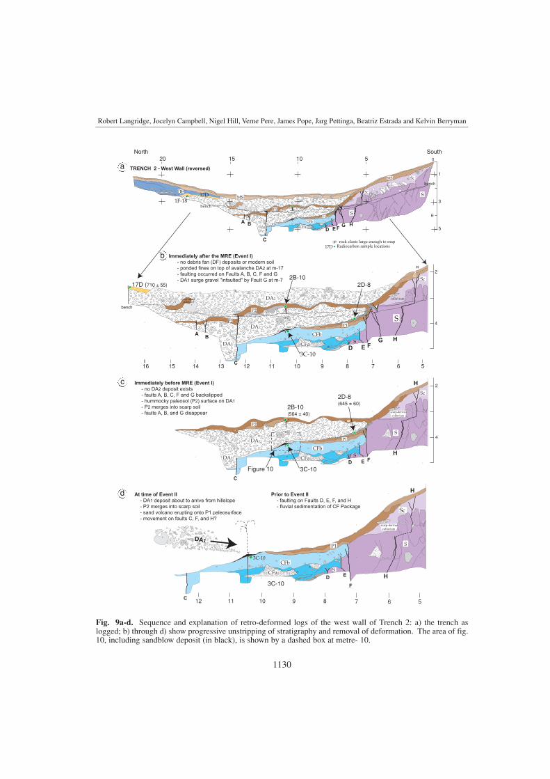
5. Trench 2
Trench 2 (T2) was excavated 50 m westof Trench 1 across the shutter scarp at a bear-ing of 002° near the outlet of the abandonedfan drainage (fig. 5). The trench was sited inthe lowest part of the basin behind the shutterscarp (fig. 8), where we suspected there wouldbe a ponded finer-grained sequence of units.The benched trench is 22 m long and has up to4.5 m relief from the top of the scarp to the bot-tom of the trench (fig. 7b). Only the west wallof this trench was logged as the units anddeformation were both very similar across thetrench.
The trench was excavated here in order tointercept: i) the highest point of the bedrockscarp and therefore scarp-derived colluvia; ii)the toe of a landslide expressed in the geomor-phology at the north end of the trench (fig. 5),and iii) a hypothesised thicker sequence ofyoung fault zone ponded alluvial deposits that
1128
Robert Langridge, Jocelyn Campbell, Nigel Hill, Verne Pere, James Pope, Jarg Pettinga, Beatriz Estrada and Kelvin Berryman

would be useful in the distinction of discreetpaleo-events.
5.1. Stratigraphy
Figure 7a,b shows both the stratigraphic andstructural comparisons between the two trench-es. The stratigraphic sequence of T2 is gener-ally younger, less complex, and less deformedthan that of Trench 1, with four packages overlain by the modern soil profile (fig. 6).Deposition patterns range from gradual, as in thedevelopment of soils and ponded fills, to chan-nel-filling alluvial deposition, to punctuated as inthe deposition of debris flows or avalanches.The Scarp Package (S) again consists mostly ofhighly sheared Torlesse sandstone, which isintensely fractured to chip-sized clasts and iscut by numerous minor shears. Above thebedrock is a 40-80 cm thick zone of large sand-
stone blocks in a weathered matrix of gravel toclay-sized fragments (fig. 9a-d). This unit rep-resents an active soil and colluvial pair formingon the fault scarp.
The stratigraphically-lowest onlap packageis the Channel Fill Package (CF), which con-sists of two main units. The lower unit (CFa)contains two channel gravels interbedded withfine-grained deposits. This is overlain by chan-nel-free yellow-brown silty clay which gradesupward into a wedge-shaped paleosol (Paleosol1) that includes pieces of charcoal. Paleosol 1(P1) thins and pinches out to the north becom-ing an organic silt, implying a facies changeinto a subaqueous pond environment (fig. 10). Weinterpret the change from gravel lenses to fine filland soil to correspond to the timing of abandon-ment of the deflected Urquhart Stream channel.
The Debris Avalanche Package is dominat-ed by two, 1 m thick, very poorly sorted,clast-supported angular greywacke sandstone
1129
fault F
fault C
shutter scarp
to abandonedoutlet
Greenburn Stream
Fig. 8. Trench 2 at the time of the 2001 ILP Meeting. The picture is taken looking southeast from a debris fanabove the trench toward Greenburn Stream. The trench reaches from the apex of the shutter scarp to the toe ofthe debris fan. Two main zones of recent fault rupture (arrows) were identified cutting the buried stratigraphy.
Paleoseismology and slip rate of the Conway Segment of the Hope Fault at Greenburn Stream, South Island, New Zealand
1130
Robert Langridge, Jocelyn Campbell, Nigel Hill, Verne Pere, James Pope, Jarg Pettinga, Beatriz Estrada and Kelvin Berryman
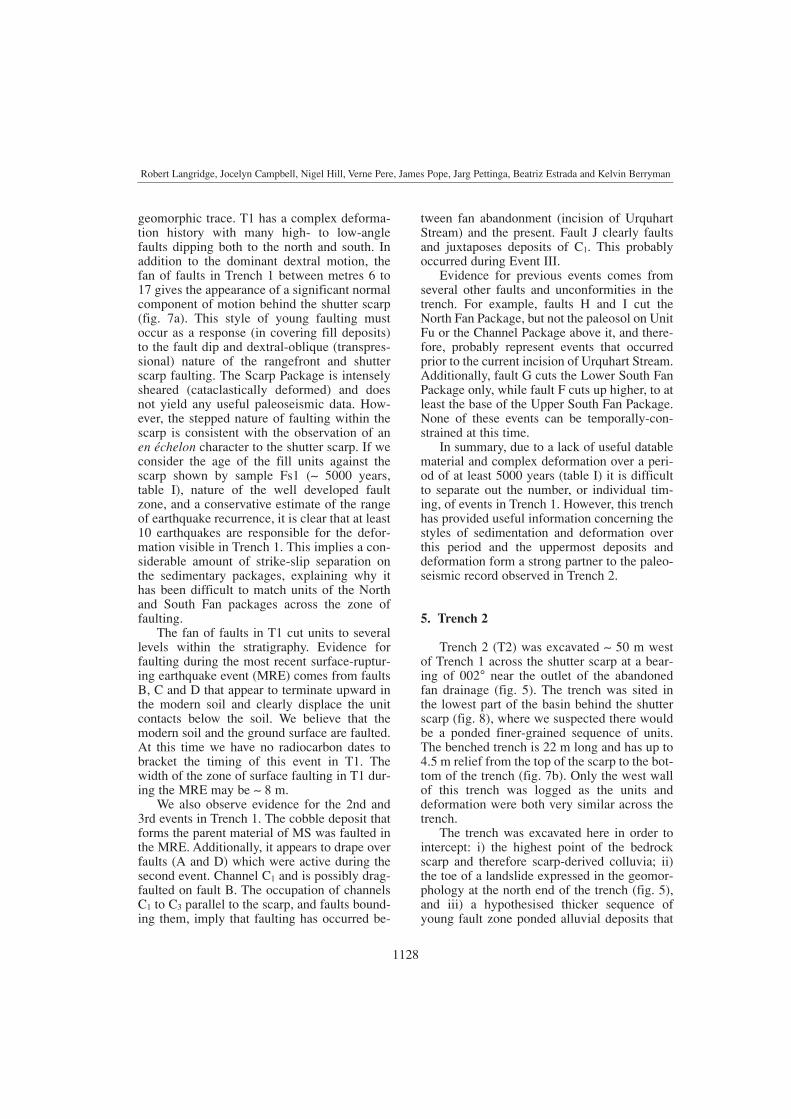
Fig. 9a-d. Sequence and explanation of retro-deformed logs of the west wall of Trench 2: a) the trench aslogged; b) through d) show progressive unstripping of stratigraphy and removal of deformation. The area of fig.10, including sandblow deposit (in black), is shown by a dashed box at metre- 10.
1D
11121516 1314
1C
r
r
r
r
r
1F-18
1C
568 7910
r
r
r
r
r
r
2C
LBUB
1G2D
2B
r
r
r
rr
r
r r
r
2D
P1
2
4
Immediately after the MRE (Event I)
- no debris fan (DF) deposits or modern soil
- ponded fines on top of avalanche DA2 at m-17
- faulting occurred on Faults A, B, C, F and G
- DA1 surge gravel "infaulted" by Fault G at m-7
2F
r
r
r
r
r
Da2
rr
A
C
B
H
17D
2C
r
r
r
r
rr
1C
r
3H 3I
3D
r r
2D
2
4
Immediately before MRE (Event I)
- no DA2 deposit exists
- faults A, B, C, F and G backslipped
- hummocky paleosol (P2) surface on DA1
- P2 merges into scarp soil
- faults A, B, and G disappear
r
r
3G
3F
3E
r
r
r
r
scarp-derived colluvium
1112
1C
568 7910
3E
3I
3D
At time of Event II
- DA1 deposit about to arrive from hillslope
- P2 merges into scarp soil
- sand volcano erupting onto P1 paleosurface
- movement on faults C, F, and H?
Prior to Event II
- faulting on Faults D, E, F, and H
- fluvial sedimentation of CF Package
3C-10r r
3F
r
SouthNorth
1520
1F-18 1C1C
1B
1A
r
r
r
r
rr
rr
r r
r
r
r rock clasts large enough to map
2B-10
1C
5 010
r
r
r
r
r
r
2C
LBUB
2B
r
r
r
rr
r
r
r
r
r
r
r
P1
1
3
5
Sc
r
bench
m
TRENCH 2 - West Wall (reversed)
A
C
BD E F
G H
rr r
r
r r r
rr
r
2G
2F
2C
3G
r
r
4
S
S
CFbCFa
MS
MS
P1
P2DA1
DA2
DA1
17D (710 ± 55)
DF
r
r
Radiocarbon sample locations17D
3F3D
r
r
r r
rr
r
r
r
rr
r
r
rip-up ofpaleosol
rr
r
r r
r
3C-10
Sc
D E FG H
r rr
r
rr colluvium
r
S
CFb
CFa
P1
P2
P2DA1
DA2
DA1
r
3F3D
2D-8
r
rr
r
r
r
r
S
S
r
r
2B-10(564 ± 40)
2D-8(645 ± 60)
r
r
3C-10
Sc
D E F
H
r rr S
CFb
CFa
P1
P2
DA1
DA1
rr
rr
S
r
r
Figure 10
Scbench
bench
C
H
H
3C-10
Sc
D E
F
H
CFb
CFa
P1
S
C
r
r
r
r
r
r rrr
rr
r
r
r
rr
r
r
rr
DA1
scarp-derived colluvium
v
v
v
3E
rr
S
A
B1
b
c
d
a

breccias (DA1, DA2), interpreted as debris ava-lanche deposits. Incorporated within these de-posits are ripped up blocks of the underlyingsoil horizons and chunky charcoal fragments.In addition, at the base and toward the toe ofthese deposits are pockets of well-sorted granu-lar gravels, and deformed obliquely-stackedsoil units, respectively. The former are inter-preted as debris avalanche surge deposits, whilethe latter are likely to be «bulldozed» toe de-posits related to the avalanches stripping off thesoil cover. Clast range in size from 1 m (soilrip-ups) to 50 cm (rock clasts), to as little assand size. The DA deposits are densely-packedbut have little definable matrix material. Thislist of features is indicative of an en masse styleof deposition or emplacement. It is likely thatthese deposits emanated from the greywackehillslopes above the trench. Unit DA1 probablycorrelates to the cobbly substrate to the modernsoil of Trench 1, the latter being a thin, distalequivalent of DA1.
Separating DA1 and DA2 is a grey-brown siltloam with mottles toward its base and a sharpupper contact. We interpret this unit to be apaleosol (Paleosol 2, P2) that was buried by the second avalanche. Included as part of the Debris Avalanche Package below DA1 is adome-shaped medium sand deposit with rem-nant vent, considered to be a preserved lique-faction sand volcano (fig. 10). No continuousfeeder dike that terminated downward into asource was exposed. However, a source (sand)layer for the sandblow was discovered ca. 1.5 mbelow it during later deepening of the trench.
The Debris Fan (DF) Package representsdeposits at the north end of the trench aboveDA2, related to the debris fan that extends alobe south toward the scarp (fig. 5). Unlike thedebris avalanche units, the Debris Fan units aregenerally well-bedded and sorted, clast-sup-ported gravels and are therefore clearly of dif-ferent origin. The DF gravels have a sheeted,non-waterlain fabric and are therefore consid-
1131
Paleoseismology and slip rate of the Conway Segment of the Hope Fault at Greenburn Stream, South Island, New Zealand
25 cm
DA1
3C-10
sandblow
remnant vent
rr
Fig. 10. Photo of trench stratigraphy at metre 10, including sandblow deposit and remnant vent (arrowed), over-lying the lateral equivalent unit to paleosol (P1), the top of which forms the event horizon for Event II, and theoverlying debris avalanche deposit, DA1.
ered to be of debris fan origin. At the base of theDF Package is an unbedded fine-grained clasticunit limited in its deposition to a small «back-basin» on top of debris avalanche DA2. Twosamples (17D and 1F-18), discussed below, weretaken from the upper surface of DA2 and overly-ing fine-grained unit. The Modern Soil (MS)overlies the Scarp, Debris Avalanche, and DebrisFan Packages. In the middle part of the trench itis a weakly-developed soil with a gravely A hori-zon and minor development of a nutty soil tex-ture. From metres 12 to 7, the three soils (includ-ing P1 and P2) converge toward the fault scarpwhere, albeit faulted, they appear to merge toform one composite soil profile on the scarp(figs. 7a,b and 9a-d).
5.2. Faulting
The geologic record in Trench 2 has beenprogressively stripped of units and retro-de-formed in fig. 9a-d to clearly demonstrate thesequence of events. The dominant mode of dis-placement (dextral) cannot be quantitativelyaccounted for in the trench. However, there isevidence of thickness changes in units and jux-taposition of dissimilar units across faults. Thezone of faulting in T2 covers a similar width ( 7 m) to that seen in Trench 1 (fig. 7a), wheremany more events have taken place over alonger timeframe. Paleoearthquake events inTrench 2 are recognised on the basis of bothstratigraphic and structural evidence.
The Most Recent Event (MRE) faultingappears to be completely buried by instanta-neous deposition of debris avalanche DA2 (fig.9b). DA2 overlies Paleosol 2, which is faultedfrom metres 12-14 by faults A-C. The apparentvertical separation across these three faults isca. 25 cm. Horizontal offset is implied from thedifference in thickness of Unit DA1 and P2
across these faults. DA2 and the modern soilhave buried and overlie the surface rupture, cre-ating the impression of a flat unfaulted surfacein the rift zone (fig. 9b). The rumpled form ofthe paleosol (P2) seen in the trench wall is mir-rored in the shape of the preserved scarp fromthe most recent event, immediately west of thetrench where no debris avalanche material was
deposited. At metre-7, at the base of the scarpwhere the geomorphic expression of faulting isgreatest, P2 was also faulted during the MRE onfault G with small vertical separation across it(< 5 cm). We infer that the debris avalancheDA2 was initiated due to strong shaking andground motions in the hillslope above thetrench site. The deposit itself is very poorly-sorted, has a brecciated texture, and shows evi-dence of surge facies and toe deposits at its baseand front. While the model of burial of theevent horizon is equivocal, the faulting itself isnot, and there does not appear to be better rea-son for the presence of such a deposit at thatstratigraphic level.
The best evidence for Event II is faulting onfault F at the main scarp that cuts Paleosol 1 andterminates at its top, not displacing the surge ortoe deposits of DA1. Fault F also juxtaposespaleosol P1 against sheared bedrock (fig. 9c).The penultimate event is also implied by anapparent increase in vertical separation on faultC from 25 cm (offset of P2) to 55 cm (offset ofCFb.) for two events. However, we recognisethat some of the observed vertical must be theresult of strike-slip separation on DA1. The liq-uefaction sandblow deposit (fig. 10) and DebrisAvalanche deposit (DA1) provide additionalevidence for the penultimate event, as punctuat-ed deposits associated with the strong groundmotions of a surface-rupturing earthquake event.Both of these deposits have a clear, instanta-neous relationship with each other and theunderlying paleosol (former ground surface).This model requires that the paleosol developedin the interseismic period. During the earth-quake a liquefaction fountain ejected sand ontothe paleosol surface, sourced from a sand layerdiscovered below the floor of the trench (fig.9d). Temporally, this deposit was almost imme-diately overlain by the debris avalanche, DA1.
Further evidence for a third paleoseismicevent is recorded at the bottom of the trenchbetween metres 7 to 8, where faults D and E cutthe lower Channel Fill Package deposits (CFa),juxtaposing those units against bedrock. Thetiming of these three events is discussed belowwith respect to the ages of radiocarbon samplesand the record in Trench 1. Additionally, thereare many mapped shears within the bedrock
1132
Robert Langridge, Jocelyn Campbell, Nigel Hill, Verne Pere, James Pope, Jarg Pettinga, Beatriz Estrada and Kelvin Berryman
scarp. Most of these have no impact upon therecent paleoearthquake story. However, fault Hat metre-5 does appear to cut the base of thecolluvial scarp deposits and is therefore likelyto have ruptured during one of the recent e-vents.
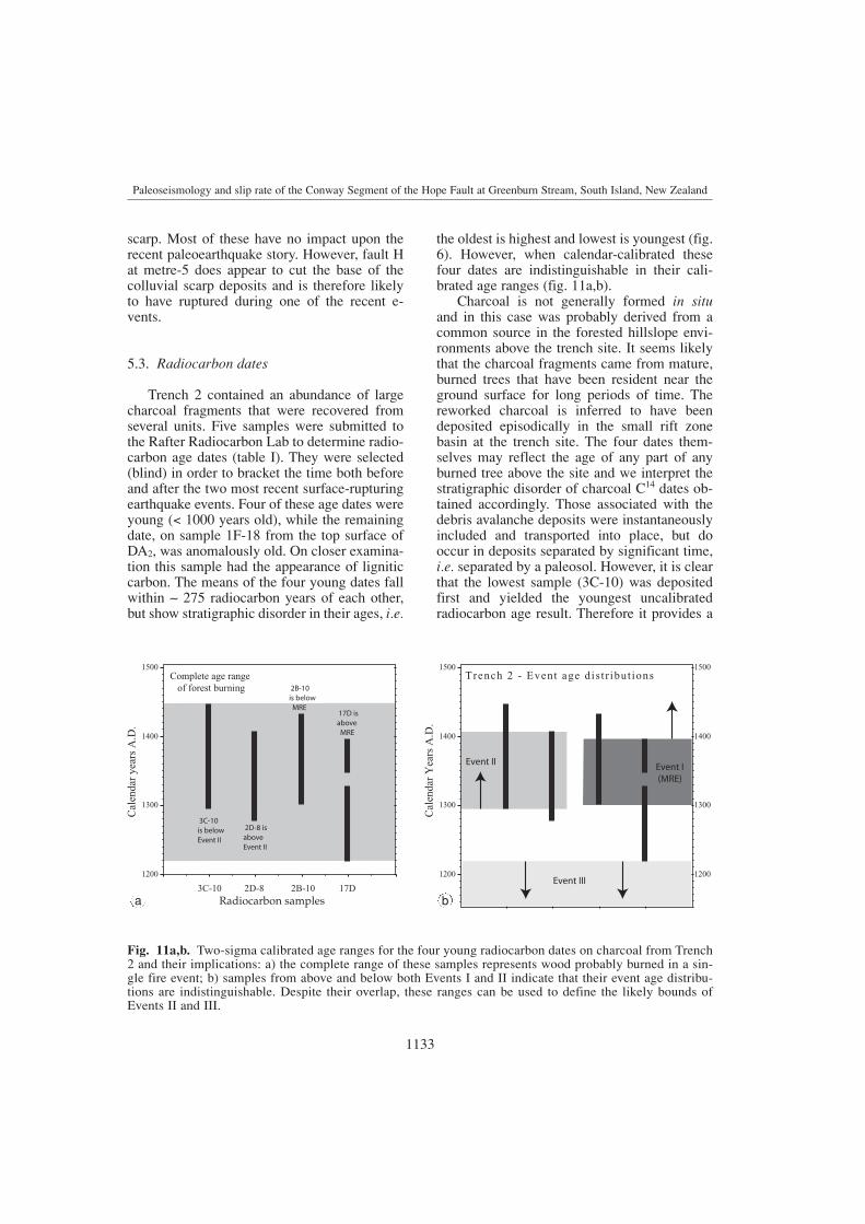
5.3. Radiocarbon dates
Trench 2 contained an abundance of largecharcoal fragments that were recovered fromseveral units. Five samples were submitted tothe Rafter Radiocarbon Lab to determine radio-carbon age dates (table I). They were selected(blind) in order to bracket the time both beforeand after the two most recent surface-rupturingearthquake events. Four of these age dates wereyoung (< 1000 years old), while the remainingdate, on sample 1F-18 from the top surface ofDA2, was anomalously old. On closer examina-tion this sample had the appearance of ligniticcarbon. The means of the four young dates fallwithin 275 radiocarbon years of each other,but show stratigraphic disorder in their ages, i.e.
the oldest is highest and lowest is youngest (fig.6). However, when calendar-calibrated thesefour dates are indistinguishable in their cali-brated age ranges (fig. 11a,b).
Charcoal is not generally formed in situand in this case was probably derived from acommon source in the forested hillslope envi-ronments above the trench site. It seems likelythat the charcoal fragments came from mature,burned trees that have been resident near theground surface for long periods of time. Thereworked charcoal is inferred to have beendeposited episodically in the small rift zonebasin at the trench site. The four dates them-selves may reflect the age of any part of anyburned tree above the site and we interpret thestratigraphic disorder of charcoal C14 dates ob-tained accordingly. Those associated with thedebris avalanche deposits were instantaneouslyincluded and transported into place, but dooccur in deposits separated by significant time,i.e. separated by a paleosol. However, it is clearthat the lowest sample (3C-10) was depositedfirst and yielded the youngest uncalibratedradiocarbon age result. Therefore it provides a
1133
Paleoseismology and slip rate of the Conway Segment of the Hope Fault at Greenburn Stream, South Island, New Zealand
1200
1300
1400
1500
Cal
enda
r ye
ars
A.D
.
3C-10 17D2D-8 2B-10Radiocarbon samples
3C-10is below Event II
2D-8 isaboveEvent II
2B-10is below MRE
17D isabove MRE
Complete age range of forest burning
1200
1300
1400
1500
1200
1300
1400
1500
Event II
Cal
enda
r Y
ears
A.D
.
Event I (MRE)
Trench 2 - Event age dis t r ibut ions
Event III
Fig. 11a,b. Two-sigma calibrated age ranges for the four young radiocarbon dates on charcoal from Trench2 and their implications: a) the complete range of these samples represents wood probably burned in a sin-gle fire event; b) samples from above and below both Events I and II indicate that their event age distribu-tions are indistinguishable. Despite their overlap, these ranges can be used to define the likely bounds ofEvents II and III.
ba

maximum age for the timing of the two paleo-seismic events that followed its deposition.
As discussed above, the four radiocarbondates have overlapping, indistinguishable cali-brated age ranges at the 2 limit (fig. 11a,b).Together with the abundance of charcoal of thesame age in units deposited by both gradual anden masse means, these results suggest a singleburn event of an old forest between 1295 and1450 A.D., that may be the result of Polynesianexpansion into Northern South Island in pre-European times.
6. Discussion
6.1. Slip rate of the Conway Segment
A new independent slip rate is determinedhere from the geomorphic offset of the aban-doned paleochannel of Urquhart Stream in con-cert with the age of associated fan deposits (fig.5). One end of the offset, defined by piercingpoint P, comes from projecting the valley axisat the head of the fan where the stream emergesfrom the mountain front, to the fault. This as-sumes that if the Hope Fault were not deflectingit, Urquhart Stream would flow straight across(perpendicular to) the mountain front. P is notlocated in the centre of the modern channel. P* isthe other piercing point and is related to the out-let of the former stream course as it crosses thefault and cuts through the scarp. P* is the projec-tion back to the fault of the straightened down-valley stretch of the former Urquhart Streambeyond the scarp. The distance PP* comes fromprogressive dextral displacement along the HopeFault related to the course and deflection ofUrquhart Stream prior to its current incision. PP*
has a value of 115 m and an associated error of± 15 m. The uncertainty comes from the combi-nation of the position of the modern channel andthe outlet of the abandoned channel.
The age of deposits related to this displace-ment is based on radiocarbon date Fs1 (table I)taken from charcoal in a basal silt layer inTrench 1 (fig. 6). This represents the oldestexposed unit containing datable material.Because we did not expose the base of the fansequence, we must consider this date to reflect
a minimum age for fan deposition within thefault furrow related to the stream deflection.Therefore, the slip rate derived from this calcu-lation is closer to a maximum rate. The combi-nation of displacement and age for the paleo-channel of Urquhart Stream produces a dextralslip rate for the Conway Segment at this site of18.9-26.8 mm/yr (rounded to 23 ± 4 mm/yr).We suspect that the actual slip rate should fallinside this maximum slip rate range.
This new data can be used to better definethe geologic slip rate for the Conway Segment.Our results compare favourably with other sliprate studies on the Conway Segment, such as the rate of 18 ± 8 mm/yr derived from HossackStation at the western end of the ConwaySegment (McMorran, 1991). Dextral slip ratesof ca. 28 and 33 ± 1.5 mm/yr have been deter-mined from offset terraces at Sawyers Creek,3 km east of this site (Van Dissen, 1989; Bull,1991). The weathering rind ages associated withthis offset were re-analysed by Pope (1994)using the calibration criteria of McSaveney(1992), yielding slip rates in the range 31-55mm/yr. Clearly, the upper end of this range isextreme, as it is greater than the whole platemotion rate for the entire MFZ (Bourne et al.,1994; De Mets et al., 1994).
In addition to our new results and using thesame method of offset geomorphology anddated deposits in trenches, we recognise acomparable value for a young offset fan at theClarence Reserve releasing step-over (Pope,1994; Campbell, 2001), 2 km to the east of our site. This site yields a slip rate of ca. 25mm/yr, implying that locally our new slip rateis a valid result. The greater weight of evi-dence, particularly from features dated byradiocarbon methods implies that the slip raterange for the Conway Segment is likely to besomewhat lower estimates than made usingweathering rind data, in accordance with ournew results.
6.2. Slip per event and recurrence interval
The average slip per event, or Single EventDisplacement (SED) mapped from offset ridges,terrace risers, and channels at 9 localities be-
1134
Robert Langridge, Jocelyn Campbell, Nigel Hill, Verne Pere, James Pope, Jarg Pettinga, Beatriz Estrada and Kelvin Berryman
tween Greenburn Stream and Sawyers Creek byPope (1994) is 5-6 m. This value is comparableto the 6 ± 2 m estimated by Bull (1991) fartherwest. At Urquhart Stream, where the slip rate iscalculated, displacements from offset featuresare measured at 3.4, 4.9 ± 0.2, and 10.4 ± 0.2 m.No new evaluation of SED has been undertak-en, therefore we apply the pre-existing datasetof Pope (1994) to the Greenburn Stream site.The Recurrence Interval (RI) for this site maythen be calculated independent of event agesusing the slip rate (23 ± 4 mm/yr) and SEDrange of 5-6 m. This yields an average RI of185-263 years. This range overlaps, but is gen-erally higher than (longer RI), the recurrencerange for the neighbouring Hope River segment(81-220 years) (Cowan and McGlone, 1991),the range calculated by Pope (1994) from datacollected locally, and recent estimates for theConway Segment (120-300 years) provided byPettinga et al. (1998, 2001). A caveat of our RIrange is that it is calculated from a lower SEDrange and a slip rate tending toward the maxi-mum. However, as shown in the next section,they compare favourably with the stratigraphicand chronologic evidence for large earthquakesat this site.
Using a variation of the v = d/t equation wecan use results from the Greenburn Stream siteto develop an independent test of our RI. Theequation we use is
RI = t1 = tn./n; where n = dn./d1.
The total displacement (dn) or deflection ofUrquhart Stream at the site is 115 ± 15 m. At 5to 6 m of displacement per event (i.e. d1), be-tween 17-26 large seismic events (n) are re-quired to achieve the displacement, dn. If theseevents occurred over a period of time (tn) repre-sented by the age of the fan deposits in Trench1 (sample Fs1), then the average recurrence forthese events (t1) is 179-311 years, consistentwith the range we calculated (185-263 years)above using the slip rate (v). Combining thesetwo techniques we present a value of 180-310years for the recurrence interval from theGreenburn Stream site. Given that only onepiece (Hope River Segment) of the Hope Faulthas ruptured during the historic period ( 160
years), we favour our results, which suggest alonger RI for at least the Conway Segment ofthe Hope Fault.
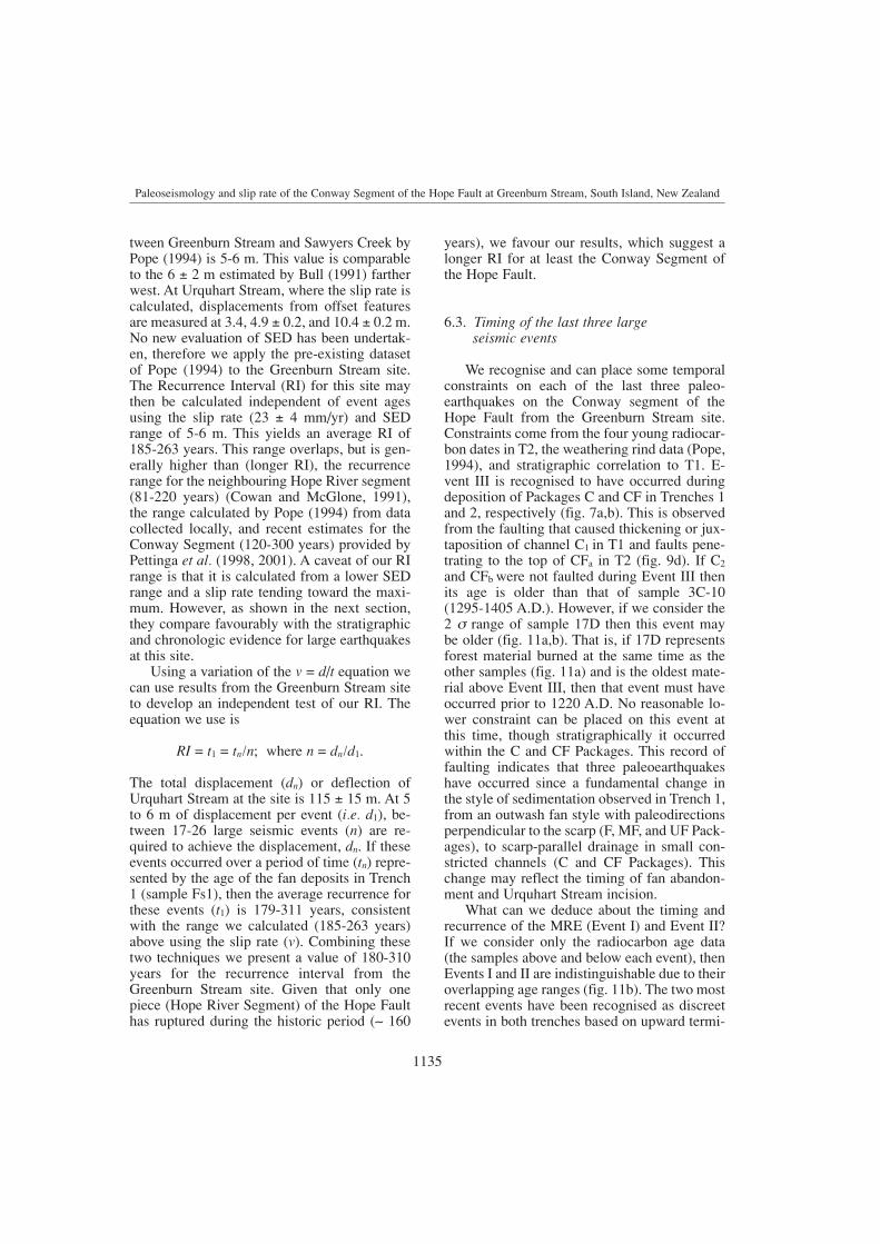
6.3. Timing of the last three large seismic events
We recognise and can place some temporalconstraints on each of the last three paleo-earthquakes on the Conway segment of theHope Fault from the Greenburn Stream site.Constraints come from the four young radiocar-bon dates in T2, the weathering rind data (Pope,1994), and stratigraphic correlation to T1. E-vent III is recognised to have occurred duringdeposition of Packages C and CF in Trenches 1and 2, respectively (fig. 7a,b). This is observedfrom the faulting that caused thickening or jux-taposition of channel C1 in T1 and faults pene-trating to the top of CFa in T2 (fig. 9d). If C2
and CFb were not faulted during Event III thenits age is older than that of sample 3C-10(1295-1405 A.D.). However, if we consider the2 range of sample 17D then this event may be older (fig. 11a,b). That is, if 17D representsforest material burned at the same time as theother samples (fig. 11a) and is the oldest mate-rial above Event III, then that event must haveoccurred prior to 1220 A.D. No reasonable lo-wer constraint can be placed on this event atthis time, though stratigraphically it occurredwithin the C and CF Packages. This record offaulting indicates that three paleoearthquakeshave occurred since a fundamental change inthe style of sedimentation observed in Trench 1,from an outwash fan style with paleodirectionsperpendicular to the scarp (F, MF, and UF Pack-ages), to scarp-parallel drainage in small con-stricted channels (C and CF Packages). Thischange may reflect the timing of fan abandon-ment and Urquhart Stream incision.
What can we deduce about the timing andrecurrence of the MRE (Event I) and Event II?If we consider only the radiocarbon age data(the samples above and below each event), thenEvents I and II are indistinguishable due to theiroverlapping age ranges (fig. 11b). The two mostrecent events have been recognised as discreetevents in both trenches based on upward termi-
1135
Paleoseismology and slip rate of the Conway Segment of the Hope Fault at Greenburn Stream, South Island, New Zealand
nations of faults and faulted horizons, support-ed by stratigraphic correlation, and a model ofinstantaneous event deposition of debris ava-lanche deposits and a liquefaction sandblow.First, we must clarify the timing of Event II.The maximum age of Event II is best con-strained by sample 3C-10 (the youngest andlowest of 4 dates) to be younger than 548 ± 60C14 years BP. Unlike the other three young sam-ples, 3C-10 was deposited in the organic siltadjacent to paleosol P1 and was faulted duringEvent II. When calendar calibrated to the 2level, this age becomes 1295-1405 A.D. (504-656 years BP). Therefore, even though the fourdated samples are likely to have a commonsource we can isolate sample 3C-10 as the onethat provides information concerning the age ofthat event horizon. Event II must be youngerthan 1295 A.D. The maximum age is alsodependent upon the length and timing of theprevious interseismic period, i.e. the periodbetween Events III and II. We recognise thatonly a few units were deposited after Event IIIand before the beginning of soil development(paleosol P1) on the CF Package. We arguebelow that such soil development requires aminimum of 160 years.
Clearly, two paleoseismic events have oc-curred on the Conway Segment since 1295A.D., and prior to the historic period, i.e. 1840A.D. Is it possible that the most recent (I) andpenultimate (II) events are broadly spaced andoccurred close to the edges of the recurrencerange? Or, were they closely spaced (clustered)in time, as suggested by Bull (1998)? As dis-cussed, the four samples that we attempted tobracket the events with have indistinguisha-ble age ranges at the 2 level. Therefore, theycannot be used to uniquely date the paleoearth-quakes themselves, i.e. the Event I and II rangesin fig. 11a,b reflect the age of a burning eventrather than two clustered earthquakes.
However, evidence for these earthquakesbeing spaced by a significant interseismic peri-od is gleaned from the history of soil develop-ment at the site. Three soils (including MS)exist in the middle part of Trench 2 (metres 7-15), which each formerly merged with the soilon the scarp. They (P1 and P2) formed theground surface prior to large earthquakes and
were buried by earthquake-induced debris ava-lanches. Interestingly, all three soils have beenthe main time units that have developed overmost of the last 3 interseismic periods, andtherefore themselves, represent the interseismicperiod. The modern soil has been forming for a minimum of 163 years (i.e. since 1840).It is weakly developed with little fine materialincluded from fluvial or aeolian input, and littleclay accumulation. Paleosol 2 is a moderately-developed soil with a thick accumulation offines and mottled B horizon. It formed betweenthe MRE and penultimate earthquakes. Pa-leosol 1 is a dark, moderately-developed soilformed on a fine-grained fill deposit against thepaleoscarp. It grades away from the scarp intoan organic-rich pond deposit (fig. 9a-d). Bothof these paleosols required significant time todevelop before being buried by debris ava-lanche deposits, possibly a factor of 2 timesmore than is seen in the modern soil. Thisamount of time (160-320 years) is equivalent tothe recurrence interval calculated previously.
Furthermore, soil accumulation at Trench 1was probably not interrupted by the depositionof scattered blocks of sandstone across its sur-face, cf. the complete burial of the soil P2 bydebris avalanche DA2 in T2 (fig. 9a-d). There-fore, in terms of time, the modern soil in T1probably represents the elapsed time required toform both Paleosol 2 and the MS in T2. In addi-tion, the cobbles on which the MS of T1 formedare equivalent in age to DA1 in Trench 2, andwere deposited en masse following Event II.These statements bear on the age bracketing ofthe MRE. The clasts on the surface of the mod-ern soil adjacent to Trench 1 are dated using theweathering rind technique at 220 ± 60 years,while the modern soil in T1 appears to be fault-ed. This evidence points to the age of the MREbeing equivalent to that of the weathering rindsurface age, i.e. 220 ± 60 years, or about 1780A.D. ± 60 years. Given the uncertainties thatmay exist in the surface age, the stratigraphiccorrelation between trenches, soil history andthe punctuated landscape change model, this isan impressive result.
By constraining the interval across whichthe MRE occurred in concert with the soil his-tory, we yield additional knowledge concerning
1136
Robert Langridge, Jocelyn Campbell, Nigel Hill, Verne Pere, James Pope, Jarg Pettinga, Beatriz Estrada and Kelvin Berryman

the minimum age of Event II. We argue thatPaleosol 2 took much more time to form thanthe modern soil, based on the accumulation offines and development of mottling (160-320years). We assert that the spacing of Events Iand II (interseismic period) is probably at theupper end of our recurrence range. This pushesthe minimum age of Event II back toward theage of the forest burning, or more reasonably towithin the period thereafter.
6.4. Implications of the timing of the MRE
The results of this work argue for a young,pre-European surface-rupturing earthquake(1780 A.D. ± 60 years) on the Conway Segmentof the Hope Fault. We consider that this rangegives the best estimate possible of the MRE,while giving due credence to the inherentuncertainties. At the upper end of this range(1840 A.D.), the historic period is encountered;thereafter it is known that no surface-rupturingevent exists for the Conway Segment. At thelower end of the range, an equivalent uncertain-ty is accounted for, representing that whichstems from our stratigraphic, dating, or defor-mation argument. One implication of this resultand the recurrence data is that we are beginningto approach, or have already entered, the lowerlimit of the recurrence range for the ConwaySegment.
How does this MRE age compare with pre-vious studies? No previous trench (on-fault)studies have produced event timing for theMRE (see McMorran, 1991; Pope, 1994). Theonly other MRE information comes fromlichenometric studies of earthquake-inducedrockfall throughout the Kaikoura ranges (Bull,1991, 1998; Bull and Brandon, 1998). Lichenre-colonisation has been used as a proxy forvery strong earthquake shaking. However, theseresults are off-fault or indirect paleoseismicindicators and so are therefore not necessarilyassociated with large earthquakes. Bull (1998)identifies two surface-rupturing events attrib-uted to the Conway segment that occur withinthe uncertainty range of our results, at 1768A.D. and at 1832 A.D. Our evidence supportsBull’s assertion that large shaking events have
occurred in the Kaikoura ranges in the recentpast, immediately prior to European settlementof New Zealand. However, our trenches showclear evidence for only one event over this timeperiod on the Conway Segment, with a signifi-cant time break (equivalent to the calculated RI) between the MRE and penultimate event,shown by the development of soil (Paleosol 2)at the site. We cannot separate or confirm thereliability of the 1768 or 1832 A.D. events,though we consider it possible that the MREobserved at Greenburn Stream is one of theseevents. Other fault segments in the region, e.g.,Kowhai Fault (fig. 3), could be the source of aseparate young, rockfall-inducing event. Infuture, more historical data from Kaikoura, anearly New Zealand whaling and sealing settle-ment may help confirm the age of the mostrecent events in the Southeastern MarlboroughFault Zone.
7. Summary
i) Two trenches were opened near Green-burn Stream on the Conway Segment of theHope Fault. These trenches were dug throughponded fill deposits against an uphill-facingscarp next to Urquhart Stream.
ii) Trench 1 intercepted alluvial fan depo-sits up to ca. 5000 years old, and showed evi-dence for multiple earthquake events. Datafrom this trench was used to develop an inde-pendent dextral slip rate of 23 ± 4 mm/yr.
iii) Trench 2 intercepted a fill of youngerdeposits and showed evidence for the last 3paleo-earthquakes. The two youngest events areconstrained by radiocarbon dates and the his-toric period to have occurred between 1295-1840 A.D. Event III probably occurred prior to1220 A.D.
iv) The age of the most recent event couldbe constrained between 1720-1840 A.D. giventhat the modern soil of Trench 1 is faulted andthat the cobbly surface deposit on it is dated at220 ± 60 years BP. Significant time exists be-tween each of these three events as observed inthe record of soil development.
v) The single event displacement based onoffset features near Urquhart Stream is 5-6 m.
1137
Paleoseismology and slip rate of the Conway Segment of the Hope Fault at Greenburn Stream, South Island, New Zealand

In combination with the calculated slip rate,age, and total displacement, the SED producesa recurrence interval of 180-310 years.
Acknowledgements
The authors wish to thank Murray Urquhart(Hawks Hill Station) for permission to accesshis farm – you are now immortalised throughthe naming of this stream. Thanks also to theILP participants for review in the field. A spe-cial thanks for assistance from ILP and the ILPConference Organisers for including the ideafor this project. We thank Tim Dawson andRamon Arrowsmith for thoughtful review com-ments. We also thank Mark Stirling and Ni-cola Litchfield of GNS for internal review com-ments and discussion that significantly improvedthis paper. This work was funded by FRST Post-Doctoral Fellowship CO5903, FRST Subduc-tion Geology 43014300 and South Island ActiveFaults 41020411, ILP Conference support, and U-niversity of Canterbury Research Grant U6451.
REFERENCES
ANDERSON, H. and T. WEBB (1994): New Zealand seismic-ity: patterns revealed by the upgraded National SeismicNetwork, N. Z. J. Geol. Geophys., 37, 477-493.
ANDERSON, H., T. WEBB and J.A. JACKSON (1993): Focalmechanisms of large earthquakes in the South Island ofNew Zealand: implications for the accommodation ofthe Pacific-Australia Plate motion, Geophys. J. Int.,115, 1032-1054.
BARNES, P.M. and J.C. AUDRU (1999): Recognition of activestrike-slip faulting from high-resolution marine seis-mic reflection profiles: Eastern Marlborough FaultSystem, New Zealand, Geol. Soc. Am. Bull., 111, 538-559.
BERRYMAN, K.R., S. BEANLAND, A.F. COOPER, H.N.CUTTEN, R.J. NORRIS and P.R. WOOD (1992): TheAlpine Fault, New Zealand: variation in Quaternarystructural style and geomorphic expression, Ann.Tectonicae, VI, 126-163.
BIBBY, H.M. (1976): Crustal strain across the MarlboroughFaults, New Zealand. N. Z. J. Geol. Geophys., 19,407-425.
BOURNE, S.J., T. ARNADOTTIR, J. BEAVAN, D.J. DARBY, P.C.ENGLAND, B. PARSONS, R.I. WALCOTT and P.R. WOOD
(1998): Crustal deformation of the Marlborough FaultZone in the South Island of New Zealand: geodeticconstraints over the interval 1982-1994, J. Geophys.Res., 103, 30,147-30,165.
BULL, W.B. (1991): Geomorphic Responses to ClimateChange (Oxford University Press, New York), pp. 326.
BULL, W.B. (1998): Lichenometry: a new way of dating andlocating prehistorical earthquakes, in Dating andEarthquakes: Review of Quaternary Geochronologyand its Application to Paleoseismology, U.S. NuclearRegulatory Commission volume, NUREG/CR-5562.
BULL, W.B. and M.T. BRANDON (1998): Lichen dating of earthquake-generated regional rockfall events,Southern Alps, New Zealand, Geol. Soc. Am. Bull.,110, 60-84.
CAMPBELL, J.K. (1973): Displacement data from the AlpineFault at Lake Rotoiti and its relevance to glacialchronology and the tempo of tectonism, in Proceedingsof the IX Congress INQUA (International Union forQuaternary Research), Abstracts volume, 57-58.
CAMPBELL, J. (2001): The Hope Fault: field trip guide, inInternational Lithosphere Program, Ten Years inPaleoseismology in the ILP, Kaikoura, New Zealand,December 2001, pp. 31
COWAN, H.A. (1989): An evaluation of the Late Quaternarydisplacements and seismic hazard associated with theHope and Kakapo faults, Amuri District, North Can-terbury, Unpublished M.Sc. Engineering GeologyThesis (lodged in the Library, University ofCanterbury), pp. 239.
COWAN, H.A. (1990): Late Quaternary displacements on theHope Fault at Glynn Wye, North Canterbury, N. Z. J.Geol. Geophys., 33, 285-293.
COWAN, H.A. (1991): The North Canterbury earthquake ofSeptember 1, 1888, J. R. Soc. N. Z., 21, 1-12.
COWAN, H.A. and M.S. MCGLONE (1991): Late Holocenedisplacements and characteristic earthquakes on theHope River Segment of the Hope Fault, New Zealand.J. R. Soc. N. Z., 21, 373-384.
DEMETS, C., R.G. GORDON, D.F. ARGUS and S. STEIN
(1994): Effect of recent revisions to the geomagneticreversal time scale on estimates of current platemotions, Geophys. Res. Lett., 21, 2191-2194.
EUSDEN, J.D., J.R. PETTINGA and J.K. CAMPBELL (2000):Structural evolution and landscape development of a transpressive duplex on the Hope Fault, NorthCanterbury, New Zealand, N. Z. J. Geol. Geophys., 43,391-404.
FREUND, R. (1971): The Hope Fault: a strike-slip fault inNew Zealand, N. Z. Geol. Surv. Bull., 86, p. 49.
GRAPES, R., T. LITTLE and G. DOWNES (1998): Rupturing of theAwatere Fault during the 1848 October 16 Marlboroughearthquake, New Zealand: historical and present day evidence, N. Z. J. Geol. Geophys., 41, 387-400.
HARDY, E.F. and H.W. WELLMAN (1984): The Alpine,Wairau and Hope faults, Victoria University ofWellington, Geology Dept. Publication, 27.
HOLT, W.E. and A.J. HAINES (1995): The kinematics ofnorthern South Island, New Zealand, determined fromgeologic strain rates, J. Geophys. Res., 100, 17,991-18010.
KIECKHEFER, R.M. (1979): Sheets M31D, N31A, N31C, andparts of M32A and M32B Leader Dale (1st edition),Sheets N31B and N31D Dillon (1st edition), in LateQuaternary Tectonic Map of New Zealand 1:50.000(Department of Scientific and Industrial Research,Wellington, New Zealand), 3 maps and text, pp. 28.
1138
Robert Langridge, Jocelyn Campbell, Nigel Hill, Verne Pere, James Pope, Jarg Pettinga, Beatriz Estrada and Kelvin Berryman

KNUEPFER, P.L.K. (1992): Temporal variations in latestQuaternary slip across the Australian-Pacific plateboundary, northeastern South Island, New Zealand,Tectonics, 11, 449-464.
LANGRIDGE, R.M. (2003): Holocene displacement and sliprate for the Hurunui section of the Hope Fault, SouthIsland, New Zealand, N. Z. J. Geol. Geophys. (in press).
LENSEN, G. (1968): Analysis of progressive fault displace-ments during downcutting at the Branch River terraces,South Island, Geol. Soc. Am. Bull., 79, 545-566.
MCCALPIN, J.P. (1996): Tectonic geomorphology andHolocene paleoseismicity of the Molesworth section ofthe Awatere Fault, South Island, New Zealand, N. Z. J.Geol. Geophys., 39, 33-50.
MCKAY, A. (1890): On the earthquakes of September 1888,in the Amuri and Marlborough Districts of the SouthIsland, N. Z. Geol. Surv. Rep. Geol. Explor., 20, 1-16.
MCMORRAN, T.J. (1991): The Hope Fault at HossackStation east of Hanmer Basin, North Canterbury,Unpublished M.Sc. Thesis (lodged in the University ofCanterbury Library, Christchurch), pp. 239.
MCSAVENEY, M.J. (1992): A manual for weathering-rinddating for sandstone clasts of the Torlesse Supergroup,Institute of Geological and Nuclear Sciences Report92/4 (Lower Hutt, New Zealand, Institute of Geol-ogical and Nuclear Sciences Ltd.), pp. 52.
PETTINGA, J.R., C.G. CHAMBERLAIN, M.D. YETTON, R.J.VAN DISSEN and G. DOWNES (1998): Earthquake sourceidentification and characterisation: stage 1 (Part A)earthquake hazard and risk assessment study, Canter-bury Regional Council CRC, Publication No. U98/10,pp. 121 and 6 appendices.
PETTINGA, J.R., M.D. YETTON, R.J. VAN DISSEN and G.DOWNES (2001): Earthquake source identification andcharacterisation for the Canterbury region, South
Island, New Zealand, Bull. N. Z. Soc. Earthquake Eng.,34, 282-317.
POPE, J.G. (1994): Secondary structures, Holocene dis-placements and paleoseismicity of the Conway Seg-ment of the Hope Fault, Greenburn Stream to SawyersCreek, Unpublished B.Sc. (Hons.) Project (GeologicalSciences Library, University of Canterbury, Christ-church, New Zealand).
REYNERS, M. and H. COWAN (1993): The transition fromsubduction to continental collision: crustal structure inthe North Canterbury region, New Zealand, Geophys.J. Int., 115, 1124-1136.
SIMPSON, R.J. (1995): The Seaward segment of the HopeFault, Seaward Kaikoura ranges, Southeast Marlbo-rough, Unpublished B.Sc. (Hons.) Project (GeologicalSciences Library, University of Canterbury).
STUIVER, M., P.J. REIMER, E. BARD, J.W. BECK, G.S. BURR,K.A. HUGHEN, B. KROMER, F.G. MCCORMAC, J. VAN
DER PLICHT and M. SPURK (1998): INTCAL98_14C:Atmospheric delta 14C and radiocarbon ages, Radio-carbon, 40, 1041-1083.
VAN DISSEN, R. (1989): Late Quaternary faulting in theKaikoura region, Southeastern Marlborough, NewZealand, Unpublished M.Sc. Thesis (Oregon StateUniversity, USA), pp. 72.
VAN DISSEN, R. and R.S. YEATS (1991): Hope Fault, Jordanthrust, and uplift of the Seaward Kaikoura Range, NewZealand, Geology, 19, 393-396.
WOOD, R.A., J.R. PETTINGA, S. BANNISTER, G. LAMARCHE
and T.J. MCMORRAN (1994): Structure of the HanmerStrike-slip Basin, Hope Fault, New Zealand, Geol. Soc.Am. Bull., 106, 1459-1473.
YEATS, R. and K.R. BERRYMAN (1987): South Island, NewZealand, and transverse ranges, California: a seismo-tectonic comparison, Tectonics, 6, 363-376.
1139
Paleoseismology and slip rate of the Conway Segment of the Hope Fault at Greenburn Stream, South Island, New Zealand

n n n n n n