Paleoseismology, Active Tectonics and Archaeoseismology
7
• • •
Transcript of Paleoseismology, Active Tectonics and Archaeoseismology

Durham Research Online
Deposited in DRO:
14 April 2016
Version of attached �le:
Published Version
Peer-review status of attached �le:
Peer-reviewed
Citation for published item:
Forlin, Paolo and Gerrard, Christopher and Petley, David (2015) 'ArMedEa project : archaeology of medievalearthquakes in Europe (1000-1550 AD). First research activities.', Miscellanea INGV., 27 . pp. 166-169.
Further information on publisher's website:
http://www.ingv.it/editoria/miscellanea/2015/miscellanea27/
Publisher's copyright statement:
Additional information:
Use policy
The full-text may be used and/or reproduced, and given to third parties in any format or medium, without prior permission or charge, forpersonal research or study, educational, or not-for-pro�t purposes provided that:
• a full bibliographic reference is made to the original source
• a link is made to the metadata record in DRO
• the full-text is not changed in any way
The full-text must not be sold in any format or medium without the formal permission of the copyright holders.
Please consult the full DRO policy for further details.
Durham University Library, Stockton Road, Durham DH1 3LY, United KingdomTel : +44 (0)191 334 3042 | Fax : +44 (0)191 334 2971
http://dro.dur.ac.uk

Istituto Nazionale diGeofisica e Vulcanologia
27
miscellaneaINGV
Abstracts Volume 6th International INQUA Meeting on Paleoseismology, Active Tectonics andArchaeoseismology19 | 24 April 2015, Pescina, Fucino Basin, Italy
Anno 2015_Numero 27m ISSN 2039-6651

Anno 2015_Numero 27mmiscellaneaINGV
6TH INTERNATIONAL INQUA MEETING ON
PALEOSEISMOLOGY, ACTIVE TECTONICS AND ARCHAEOSEISMOLOGY
19 | 24 APRIL 2015, PESCINA, FUCINO BASIN, ITALY
Editors Anna Maria Blumetti, Francesca Romana Cinti, Paolo Marco De Martini, Fabrizio Galadini, Luca GuerrieriAlessandro Maria Michetti, Daniela Pantosti, Eutizio Vittori
27
ISSN 2039-6651
6th International INQUA Meeting on Paleoseismology, Active Tectonics and Archaeoseismology, 19-24 April 2015, Pescina, Fucino Basin, Italy
INQUA Focus Group on Paleoseismology and Active Tectonics
ArMedEa project: archaeology of medieval earthquakes in Europe (1000-1550 AD). First research activities
Forlin, P. (1), Gerrard, C. (1), Petley, D. (2)
(1) Department of Archaeology, Durham University, South Road, Durham, DH1 3LE, UK. Email: [email protected] (2) School of Environmental Science, University of East Anglia, Norwich Research Park, Norwich, NR4 7TJ, UK Abstract: This paper introduces the research of the Armedea project. Armedea (Archaeology of medieval earthquakes in Europe, 1000-1550 AD) is a medieval archaeology project undertaken at the Department of Archaeology of Durham University which analyses archaeological evidence related to late medieval seismic-affected contexts at a European scale. This project is therefore focused on both earthquake effects on archaeological sites, their standing buildings and environment, and the archaeological evidence that reveals the response of medieval societies in terms of risk reduction, protection and resilience. A first preview of GIS analysis of seismic activity impact on medieval societies and fieldwork activities carried out in Italy, Cyprus and Azores (Portugal) is presented here. This research is supported by a Marie Curie Intra European Fellowship within the 7th European Community Framework Programme. Key words: Medieval Archaeology, Medieval Europe, historical seismicity, GIS, fieldwork. INTRODUCTION Seismic catalogues of historic events play a significant role in hazard mitigation across the European Union. These projects are based mainly on documentary surveys or driven from an earth-science perspective but the archaeological verification for seismic activity remains under-researched. The aim of ArMedEa project (April 2014 - March 2016) is to develop more fully the analysis of the physical impacts of and human reaction to earthquakes, tsunamis and seismic-induced landslide during the later Middle Ages (Gerrard and Petley, 2013). Our work is at a European scale and adopts a specifically archaeological approach to collate and integrate information from a wide range of sources including standing buildings, buried stratigraphical sequences and palaeoenvironmental data. The main objectives of the ArMedEa project are fourfold: 1 - To develop a geographical database (GIS) able to collect, organise and interrogate archaeological and environmental evidence related to seismic events in the Middle Ages, drawing on existing catalogues, publications and untapped ‘grey literature’; 2 - to create maps which appropriately quantify exposure to seismic risk in the later medieval period, taking into account changing medieval population densities through time against actual seismic hazards maps. A similar analysis will be carried out to understand the impact of known earthquakes on medieval societies through a comparison of the same population density maps with the isoseismal maps of the most significant medieval earthquakes; 3 - To investigate a sample of well-documented episodes using a combination of remote sensing and fieldwork. These case-studies will be located in different European countries, such as Spain, Portugal, Italy, Greece and Austria, for instance; 4 - To understand the ‘risk-sensitive tactics’ adopted by medieval societies in different regions, particularly their
resilience and hazard reduction strategies from an archaeological perspective.
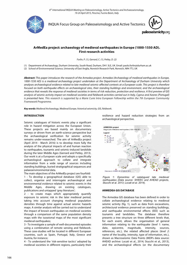
ARMEDEA GIS DATABASE The Armedea GIS database has been defined in order to collate archaeological evidence relating to medieval seismic activity (fig. 1), such as data from excavations, architectural evidence preserved on standing buildings, and earthquake environmental effects (EEE) such as tsunamis and landslides. The database therefore presents a tree structure on three different levels that, for each event, allows the organisation of general information relating to the earthquake (level 1: name, date, epicentre, magnitude, intensity, sources, references, etc.), the related affected places (level 2: name of the locality, intensity, type of information, etc.), shown as Macroseismic Data Points (MDPs data source: AHEAD archive: Locati et al., 2014; Stucchi et al., 2013), and the archaeological effects (or the documentary
Figure 1: Epicentres of catalogued late medieval earthquakes (Data source: SHEEC and AHEAD projects, Stucchi et al. 2013; Locati et al. 2014).
166

6th International INQUA Meeting on Paleoseismology, Active Tectonics and Archaeoseismology, 19-24 April 2015, Pescina, Fucino Basin, Italy
INQUA Focus Group on Paleoseismology and Active Tectonics
sources that recorded them) within each MDP (level 3: data from excavations, architectural evidence, tsunami, landslide, with details). This catalogue will allow us to implement queries about the quality and geographical distribution of information, the nature of the damage and strategy of response relating to the medieval earthquakes in Europe during the period 1000-1550 AD from an archaeological perspective. Earthquakes occurring up to the beginning of the 13th century have been recorded so far. Figure 2 shows an output map from the Veronese earthquake (1117 AD, highest intensity = IX) file, indicating buildings and archaeological excavations with seismic-related evidence in the Dome’s area of Padua (after Brogiolo, 2011, p. 62, fig. 38).
EARTHQUAKES IMPACT ON MEDIEVAL SOCIETIES AND ECONOMIC ACTIVITIES By virtue of national and international historical seismic catalogues, we already know with a reasonable accuracy where earthquakes occurred during the late Middle Ages in Europe. The real unknown is to gauge how great the impact of these seismic events was on societies and their economies. GIS data management allows us to run a crude analysis to quantify the effects of catalogued earthquakes on people and economic activity in medieval Europe. To do this, a set of preliminary maps was created showing the medieval population density for every century in 1000-1550 time-window (fig. 3). These data were obtained from pre-existing studies of medieval demography (for instance, Malanima, 2010) which illustrate, for example, regions of Europe with the highest population density during the Middle Ages (Italy and Flanders), and fluctuations in European medieval population, characterised by progressive growth up to 1348 followed by a profound contraction and a weak recovery. The creation of those maps is still in progress, and a greater refinement of regional-scale outputs is currently underway.
The next step is to overlay these population and urban density maps with raster maps displaying the macro-seismic effects (isoseismal maps) of each single medieval earthquake with an equivalent calculated magnitude ≥ 5. The end result, therefore, will be a set of maps showing the degree of seismic impact in terms of population affected by the catalogued seismic activity.
Nevertheless, we need to take into account that population density and seismic recording represent two parameters that may provide a false positive when correlated (the denser the population and the higher the economic activity, the greater the accuracy of the historical information). To avoid this, actual seismic hazard maps will be compared against both medieval population density maps and medieval seismic activity maps. Only then we can identify regions in which exposure to seismic activity has been underestimated because of a lack of relevant information. In addition, one outcome of this analysis will be therefore an archaeological predictive ‘risk’ map that infers the distribution of seismic-related sites in medieval Europe, but within a contemporary social and economic context. ARMEDEA CASE STUDIES AND FIELDWORK Armedea aims to develop fieldwork on several European areas affected by seismic activity during the Middle Ages (fig. 4). So far, five case studies have been selected. They are:
Azores (earthquake and landslide in 1522);
Figure 2: Padua, Piazza del Duomo. Gis map showing catalogued buildings and excavations with earthquake archaeological evidence.
Figure 3: Mosaic of European population density maps in 1000-1500 AD time-window.
167

6th International INQUA Meeting on Paleoseismology, Active Tectonics and Archaeoseismology, 19-24 April 2015, Pescina, Fucino Basin, Italy
INQUA Focus Group on Paleoseismology and Active Tectonics
Andalusia (earthquakes during the 12th and 13th century);
Northern Italy and Carinthia, Austria (earthquakes and landslides in 1117, 1222 and 1348);
Crete (earthquake 1303); Cyprus (earthquakes, tsunamis and landslides
in 1222 and 1491). By the end of 2014, preliminary fieldworks have been carried out in Cyprus and in the Azores. In Saõ Miguel, the largest Azorean island, a preliminary evaluation of the archaeological potential of the ancient Vial da Franca do Campo site was undertaken (fig. 5). On October 22nd, 1522, a Mw 5.0-5.9 earthquake triggered several landslides on the island of Saõ Miguel. The largest one was activated by an active fault identified east of the Fogo volcano on the Achada das Furnas plateau (Carmo et al., 2013). This mass movement, the volume of which has been calculated as 6.75×10⁶ m3 with an extension of 4.5 km2 (Marques et Al. 2009), buried most of the settlement of Vila Franca do Campo, then-capital of Portuguese Azores, killing ca. 5000 people according to contemporary sources (Frutuoso, 1981). Archaeological investigations carried out during the
1960s and ‘70s by a local archaeologist, Sousa d’Oliveira (Bento, 1989), identified several remains of the buried settlement at a depth of between 2 and 5 m underneath the actual surface. However, the quality of the archaeological documentation was not detailed; only very approximate plans and sections were produced. Nevertheless, the site presents a very high archaeological potential, as most of the ancient Vila Franca do Campo possibly lies preserved beneath this mass movement deposit. Preliminary fieldwork conducted in November gave us the opportunity to cross-reference available archaeological and palaeoenvironmental information, as shown by the attached GIS map. A first evaluation of the archaeological deposit distribution has therefore been assessed in order to consider possible future research. This case study allows us to open an exceptional window on the effects of the seismic event, but also on the reaction activated by the local population. Since the ‘new’ Vila Franca do Campo was founded along the western side of the landslide (for instance, the convent of São Francisco was built immediately after the earthquake in 1522), this context can be seen as an extraordinary example of resilience of that community, who again faced another destructive earthquake in 1536.
Figure 5: Map showing the distribution of the archaeological sites found by Oliveira (Bento 1989) in relationship with the landslide that buried the old Vila Franca do Campo in 1522 (after Marques et al. 2009).
168

6th International INQUA Meeting on Paleoseismology, Active Tectonics and Archaeoseismology, 19-24 April 2015, Pescina, Fucino Basin, Italy
INQUA Focus Group on Paleoseismology and Active Tectonics
In Cyprus, research has focused on sites affected by earthquakes in 1222 and 1491. At Saranda Kolones, Paphos, a Crusader castle completely destroyed by 1222 earthquake (fig. 6), and at churches in Nicosia and Famagusta severely damage by 1491 seismic event, preliminary EAE (earthquake archaeological effects) analysis allowed to recognise several structural damages such as detached walls, penetrative fractures in walls, displaced masonry blocks, collapsed vaults, deformed arches and columns. Consultation of local archives under the supervision of the Department of Antiquities of Cyprus has begun, and unpublished evidence about the destruction of Saranda Kolones site, for instance, has been identified. Moreover, a preliminary mapping of landslides possibly related with the aforementioned events has been carried out in the surroundings of Satvrovouni and Chrysoroiatissa monasteries. Archaeological contexts in Cyprus are of primary interest as they show different strategies of response to medieval seismic effects, ranging from complete site abandonment to articulated efforts in reconstructing, reshaping and restoring the damaged buildings.
In northern Italy, fieldwork is mainly focused on those medieval cities that suffered during the 1117 AD earthquake. A reassessment of some urban archaeological sequences and architectural remains is currently in progress, above all in Veneto’s cities such as Verona, Vicenza and Padua. Here, new data on 1117 earthquake effects are emerging with data crossing of published and unpublished researches with recent fieldwork and excavation. This event appears crucial in terms of medieval response to seismic risk analysis since it affected a large portion of what was one of the most densely inhabited and economically significant European region. Again, archaeological evidence allows us to open a new window on 12th century northern Italian societies and on their effort to react to one of the most destructive seismic events that this region has suffered during the last 2000 years.
Acknowledgements: We would like to thank the Department of Antiquities of Cyprus, the Soprintendenza per i Beni Archeologici del Veneto, prof. Gian Pietro Brogiolo (University of Padua), prof. Massimiliano Stucchi, dr. Mario Locati (INGV) and José Bettencourt (University of Lisbon) for their support. References Bento, C.M., (1989). Escavações Arqueológicas em Vila Franca do
Campo 1967-1982. São Miguel. Associação Arqueológica do Arquipélago dos Açores.
Brogiolo, G.P., (2011). Architetture religiose a Padova, In: Padova, architetture medievali. Progetto ARMEP (2008-2010) (Chavarria Arnau, A., ed.), Mantova, 35-74.
Carmo, R., J. Madeira, A. Hipólito, T. Ferreira, (2013). Paleoseismological evidence for historical surface faulting in São Miguel island (Azores). Annals of Geophysics. 56, 6, 2013, S0671. doi: 10.4401/ag-6221.
Frutuoso, G., (1522-1591†). Livro Quarto das Saudades da Terra, In: Saudades da Terra. (Frutuoso, G., ed.), 2a ed. Ponta Delgada. Instituto Cultural de Ponta Delgada. II, 1981.
Gerrard, C.M. and D. Petley, (2013). A risk society? Environmental hazards, risk and resilience in the later Middle Ages in Europe. Natural Hazards. June 2013. doi: 10.1007/s11069-013-0750-7.
Locati, M., A. Rovida, P. Albini and M. Stucchi, (2014). The AHEAD Portal: A Gateway to European Historical Earthquake Data. doi: 10.1785/0220130113
Malanima, P., (2010). Pre-modern European economy. One thousand years (10th-19th centuries). Leiden-Boston, Bril.
Marques, R., J.L. Zêzere, J.L. Gaspar, P. Amaral, (2009). Reconstituição e modelação probabilística da escoada detrítica de Vila Franca do Campo desencadeada pelo sismo de 22 de Outubro de 1522 (S. Miguel, Açores). Publicações da Associação Portuguesa de Geomorfólogos. Volume VI, APGEOM. Braga. 2009. p. 175-182.
Stucchi M., A. Rovida, A.A. Gomez Capera, P. Alexandre, T. Camelbeeck, M.B. Demircioglu, P. Gasperini, V. Kouskouna, R.M.W. Musson, M. Radulian, K. Sesetyan, S. Vilanova, D. Baumont, H. Bungum, D. Fäh, W. Lenhardt, K. Makropoulos, J.M. Martinez Solares, O. Scotti, M. Živcic, P. Albini, J. Batllo, C. Papaioannou, R. Tatevossian, M. Locati, C. Meletti, D. Viganò, and D. Giardini, (2013). The SHARE European Earthquake Catalogue (SHEEC) 1000-1899. Journal of Seismology. doi: 10.1007/s10950-012-9335-2.
Figure 6: Paphos, Cyprus. Saranda Kolones Crusader castle. Internal pilaster with penetrative fractures.
169