
Tectonic Geomorphology and Paleoseismology
104
Tectonic geomorphology and paleoseismology RNDr. Petra Štěpančíková, Ph.D. Institute of Rock Structure and Mechanics Czech Academy of Sciences, Prague, Czech Republic Department of Engineering Geology
Transcript of Tectonic Geomorphology and Paleoseismology

Tectonic geomorphology and
paleoseismology
RNDr. Petra Štěpančíková, Ph.D.
Institute of Rock Structure and Mechanics
Czech Academy of Sciences, Prague, Czech Republic
Department of Engineering Geology

Outline:
1. Definition of active tectonics, tectonic processes and their types
related to different tectonic regimes
3. Tectonic geomorphology, tectonic control on landscape evolution
4. Response of tectonic processes in fluvial systems, asymmetry of
river basins, related increased erosion and accumulation, river
pattern analysis
2. Landforms characteristic for different types of tectonic movements
(horizontal or vertical)

5. Analyses of fluvial landforms affected by tectonic movements – river
terraces, alluvial fans, analysis of longitudinal river profile and valley
cross sections
6. Fault scarps, their evolution, erosion
7. Paleoseismology, study of prehistoric earthquakes from geological
record, reconstruction of movements
8. Study of paleoseismic parameters of active faults, intensity of
movements, average slip rate, spatio-temporal distribution within the
fault

Active tectonics, tectonic processes and their types
resulting from different tectonic regimes
Tectonics – endogenous processes, structures and landforms
associated with Earth´s crust deformation (movements of lithospheric plates)

Lithosphere = solid shell of the Earth (up to 100 km)
Earth´s crust + uppermost solid mantle
continental crust (30-80km), density 2.7 g/cm3
Sedimentary, granitic, basaltic layer
oceanic crust (5-10km), density 2.9 g/cm3
Sedimentary, basaltic layer
direct observations – drills, geologic information (xenolites)
Mohorovičič discontinuity –
crust/mantle – density change, higher
velocity P-waves
Lithosphere / asthenosphere
(semifluid) 3.6 g/cm3, lower viscosity
– below lithospheric plates – velocity of seismic waves
Seismogenic crust!

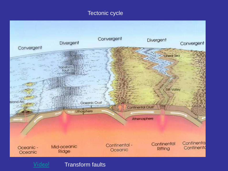
Global scale tectonics: origin of continents and ocean basins
Plate tectonics

107 m
10,000 km
Scale 1:100,000,000 106 m
1000 km
Scale 1:10,000,000
Regional Neotectonics
Satellite images
Global Neotectonics
mountain chains microplates

105 m
100 km
Scale 1:1.000,000 104 m
10 km
Scale 1:100,000
103 m
1 km
Scale 1:10,000
Local scale: individual landforms such as folds,
fault scarps, small hills etc.
satellite images
Active Tectonics
Tectonic Geomorphology

10-1 m
10 cm
Scale 1:1
100 m
1 m
Scale 1:10
101 m
10 m
Scale 1:100
Structural Geology
Petrology
outcrop/ hand sample
offset channels
tectonic breccia
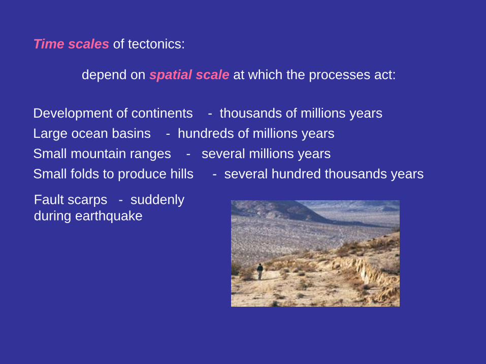
Time scales of tectonics:
depend on spatial scale at which the processes act:
Development of continents - thousands of millions years
Large ocean basins - hundreds of millions years
Small mountain ranges - several millions years
Small folds to produce hills - several hundred thousands years
Fault scarps - suddenly
during earthquake
Neotectonics - crustal movements starting after the youngest orogenic
phase or related to the youngest stress field occurring in the late
Neogene and Quaternary
Active tectonics – tectonic processes that caused deformation of
the Earth´s crust of local scale and on a time scale
significant for humans (earthquakes)
Active faults – have moved during last 10.000 yrs – Holocene
(paleoseismology)
Potentially active faults (capable faults) – have moved during Quaternary
(2.6 million yrs)
Rates of tectonic processes:
Very variable – 0.00X-X mm/year for fault displacement
X cm/year for movement on plate boundaries

Tectonic processes - driven by
forces in the depth that deform
the crust => origin of ocean
basins, continents, mountains
Litosphere broken into plates - relatively move; triple junction

divergent – extension (spreading), convergent – shortening (subduction) video!

Video!
Summary video

Active Tectonics: confirmation of plate tectonics…
• Earthquakes
• Volcanoes
• Faults
World Seismicity, 1963–2000
video
• Topography
• Surface
deformation

Tectonic movements
• Producing new lithosphere in ocean ridges, subduction
of old one and plates sliding along each other – produce
stress (force per unit area) and strain (deformation –
change in length, volume).
• Seismic movements
- accompanied by earthquakes
• Aseismic movements (tectonic creep)
- more or less continuous movements with minimal
seismicity, confined to narrow zone

Seismic tectonic movements
When the stress exceeds the strength of rocks, then rocks fail (rupture),
energy is released in a form of an earthquake (elastic seismic waves)
and faulting (breaking the rocks, rock deformation).
Foreshocks – low intensity
Main shock – tens of seconds to minutes with
maximum intensity
Aftershocks – several months with decreasing
effects
seismograph
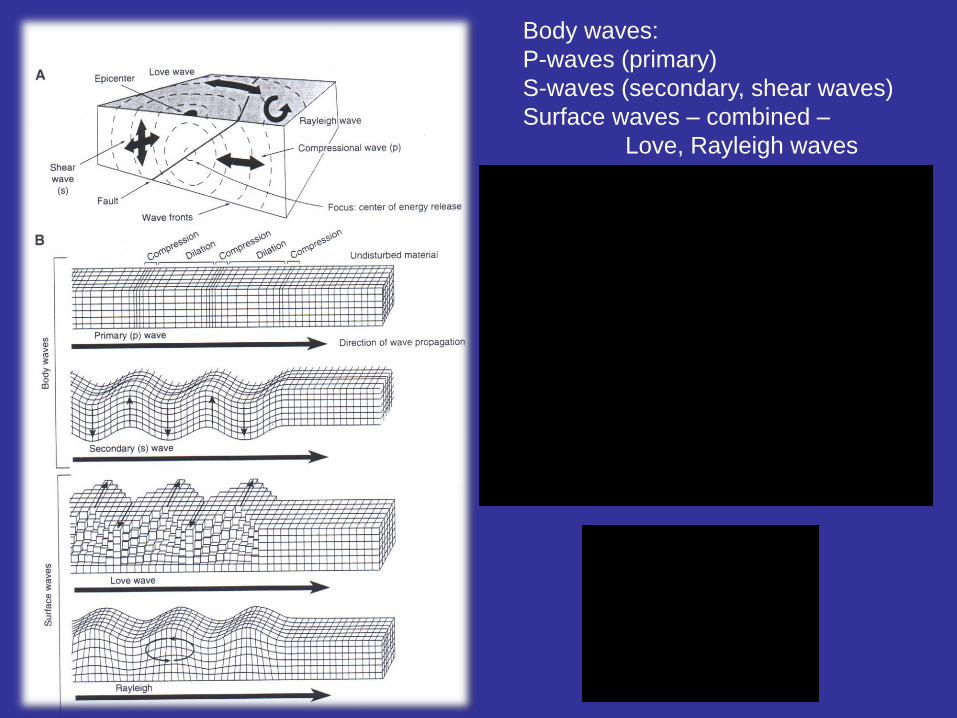
Body waves:
P-waves (primary)
S-waves (secondary, shear waves)
Surface waves – combined –
Love, Rayleigh waves

Epicentre location
Estimation of epicentre distance - based on time difference between P and S waves
P-waves followed
by S-waves

Earthquake cycle (seismic cycle):
1. accumulation of stress = produces elastic
strain (not permanent)
2. during earthquake stress is released
when rocks break and permanent
displacement occurs, then strain also
drops (stress drop)
3. = elastic rebound (deformed material in
the original shape)
Video!
After the earthquake, stress is accumulated again
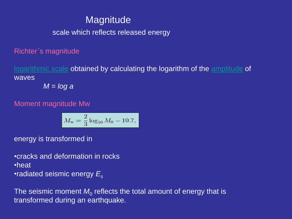
Magnitude
scale which reflects released energy
Richter´s magnitude
logarithmic scale obtained by calculating the logarithm of the amplitude of
waves
M = log a
Moment magnitude Mw
energy is transformed in
•cracks and deformation in rocks
•heat
•radiated seismic energy Es
The seismic moment M0 reflects the total amount of energy that is
transformed during an earthquake.
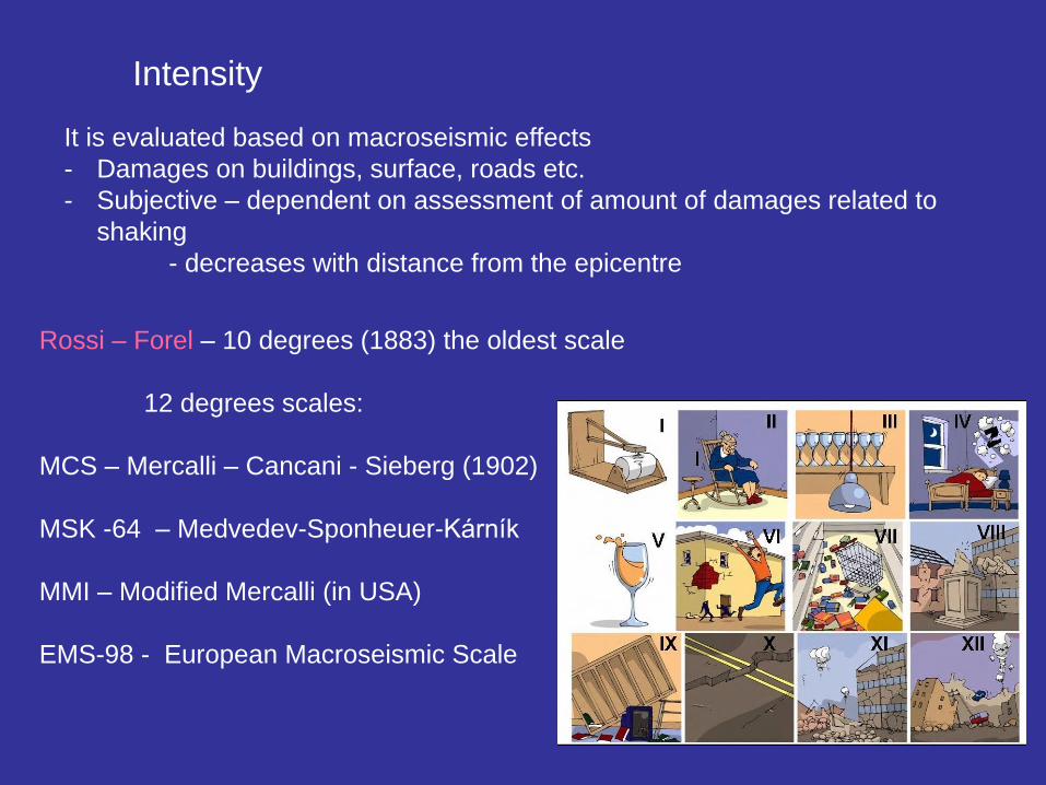
Rossi – Forel – 10 degrees (1883) the oldest scale
12 degrees scales:
MCS – Mercalli – Cancani - Sieberg (1902)
MSK -64 – Medvedev-Sponheuer-Kárník
MMI – Modified Mercalli (in USA)
EMS-98 - European Macroseismic Scale
Intensity
It is evaluated based on macroseismic effects
- Damages on buildings, surface, roads etc.
- Subjective – dependent on assessment of amount of damages related to
shaking
- decreases with distance from the epicentre

EMS-98
European
Macroseismic
Scale
I. Not felt Not felt by anyone.
II. Scarcely felt Vibration is felt only by individual people at rest in houses, especially on
upper floors of buildings.
III. Weak The vibration is weak and is felt indoors by a few people. People at rest feel
swaying or light trembling. Noticeable shaking of many objects.
IV. Largely observed
The earthquake is felt indoors by many people, outdoors by few. A few
people are awakened. The level of vibration is possibly frightening. Windows,
doors and dishes rattle. Hanging objects swing. No damage to buildings.
V. Strong
The earthquake is felt indoors by most, outdoors by many. Many sleeping
people awake. A few run outdoors. Entire sections of all buildings tremble.
Most objects swing considerably. China and glasses clatter together. The
vibration is strong. Topheavy objects topple over. Doors and windows swing
open or shut.
VI. Slightly damaging
Felt by everyone indoors and by many to most outdoors. Many people in
buildings are frightened and run outdoors. Objects on walls fall. Slight
damage to buildings; for example, fine cracks in plaster and small pieces of
plaster fall.
VII. Damaging
Most people are frightened and run outdoors. Furniture is shifted and many
objects fall from shelves. Many buildings suffer slight to moderate damage.
Cracks in walls; partial collapse of chimneys.
VIII. Heavily damaging
Furniture may be overturned. Many to most buildings suffer damage:
chimneys fall; large cracks appear in walls and a few buildings may partially
collapse. Can be noticed by people driving cars.
IX. Destructive Monuments and columns fall or are twisted. Many ordinary buildings partially
collapse and a few collapse completely. Windows shatter.
X. Very destructive Many buildings collapse. Cracks and landslides can be seen.
XI. Devastating Most buildings collapse.
XII. Completely
devastating All structures are destroyed. The ground changes.

Macroseismic effects on the surface controlled by:
• Size of earthquake, focus depth, distance from epicentre, rheology of the surface layers
• Locally – types and physical condition of the rocks,
ground water level,
geology - site effects
Larger amplitude – worse damages
Mexico city 1985, M = 8,
epicentre 350km far away,
10,000 casualties
- Unconsolidated sediments
and soil – shaking is amplified
- Sediments thickness above
hardrock – amplified if higher
thickness
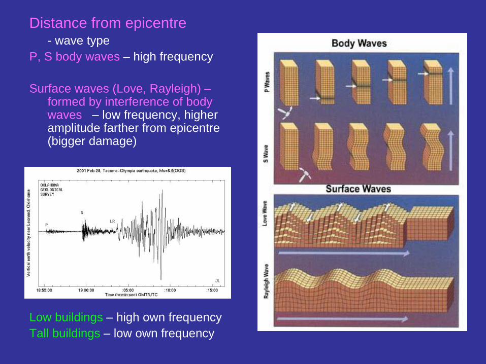
Distance from epicentre - wave type
P, S body waves – high frequency
Surface waves (Love, Rayleigh) – formed by interference of body waves – low frequency, higher amplitude farther from epicentre (bigger damage)
Low buildings – high own frequency
Tall buildings – low own frequency
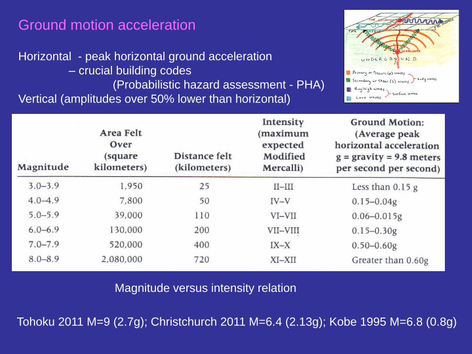
Ground motion acceleration Horizontal - peak horizontal ground acceleration
– crucial building codes
(Probabilistic hazard assessment - PHA)
Vertical (amplitudes over 50% lower than horizontal)
Magnitude versus intensity relation
Tohoku 2011 M=9 (2.7g); Christchurch 2011 M=6.4 (2.13g); Kobe 1995 M=6.8 (0.8g)

Effects of earthquakes
Primary effects: ground-shaking motion and rupture of the surface
(shear or collapse of large buildings, bridges, dams, tunnels, pipelines)
Chi-chi EQ Taiwan 1999 with M=7.6 Landers EQ, Emerson fault, CA 1992, M=7.3

Secondary effects:
Liquefaction – water-saturated material transforms to liquid state (loose soil
into mud) during shaking, compaction causes an increase of pore-water
pressure = material loses shear strength and flows.
Water under the soil rises and the ground sinks causing extensive damage to
buildings, roads and other structures.
Buildings tilted due to soil
liquefaction,1964
earthquake, Japan.
video
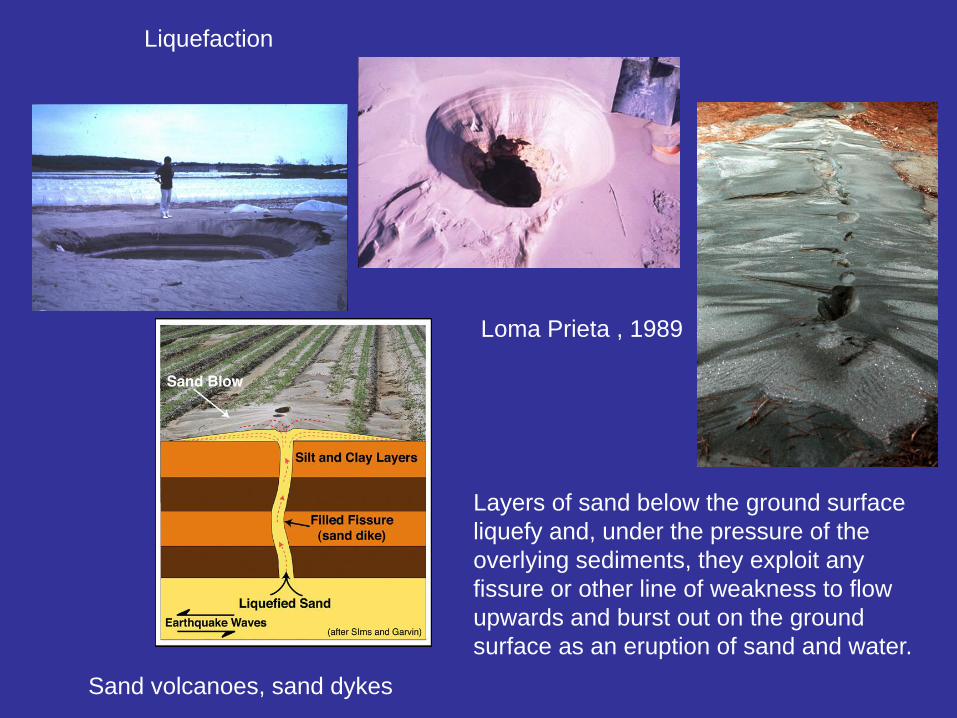
Liquefaction
Sand volcanoes, sand dykes
Layers of sand below the ground surface
liquefy and, under the pressure of the
overlying sediments, they exploit any
fissure or other line of weakness to flow
upwards and burst out on the ground
surface as an eruption of sand and water.
Loma Prieta , 1989
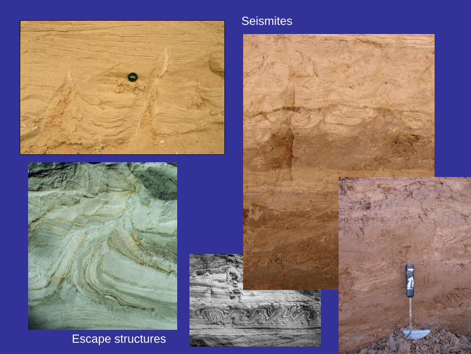
Escape structures
Seismites
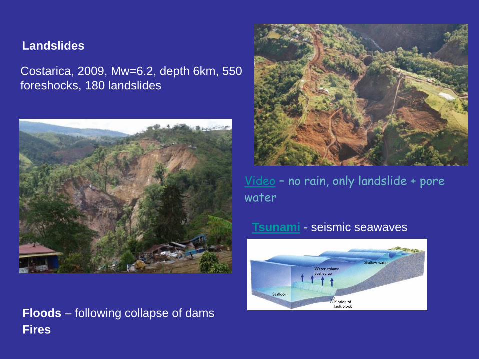
Landslides
Costarica, 2009, Mw=6.2, depth 6km, 550
foreshocks, 180 landslides
Tsunami - seismic seawaves
Video – no rain, only landslide + pore
water
Floods – following collapse of dams
Fires
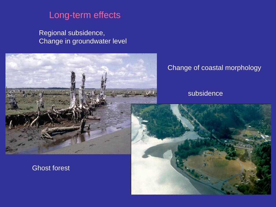
Long-term effects
Regional subsidence,
Change in groundwater level
Change of coastal morphology
subsidence
Ghost forest

Tectonic creep – aseismic movements
Geodetically detectable (GPS, InSAR,
creepmeter etc..... )
Less damage from creep – generally along
narrow fault zones subject to slow
movements,
Not much studied – no seismic hazard
Displacement along a fault zone accompanied by minimal earthquakes,
more or less continuous, confined to narrow zone

Hayward fault – SAF zone, San Francisco
Bay area
Creep rate measured by creepmeter installed across the fault – typically 5 mm/year,
max in Fremont 7.8 - 8.5 mm/year
Creepmeters

Between 5 and 12 km in depth
is believed to slip entirely in
earthquakes, but the surface
and deepest part of the fault
also slips by a process of
aseismic creep.
High rate: slow damage of
roads, sidewalks, building
etc.
Creep since 1896 large EQ, the creep partially releases the strain energy on the
fault

Berkeley – Memorial stadium
3.2 cm in 11 years,
periodic repairs needed
Hayward faults

Berkeley, offset sidewalk
Contra Costa,
deformed road
Hayward, offset fence

Higher creep rate:
Calaveras fault (SAF zone)
Creep rate – varies
1910-1929 no creep, based on offset in two sidewalks constructed in 1910 and
1929, and pipeline laid in 1929
1929 ......- creep commenced, with 8 mm/yr (average)
1961 - 1967, slip rate about 15 mm/yr
1979....2 sites monitored in Hollister with 6.6 mm/yr and 12 mm/yr (2.3km NW)
20.000 earthquakes a year - small, strain not
accumulated and it is released by slow creep – not
able to produce a large earthquake
Hollister, twisted house

Calaveras fault - winery
Calaveras fault

Creeping tree

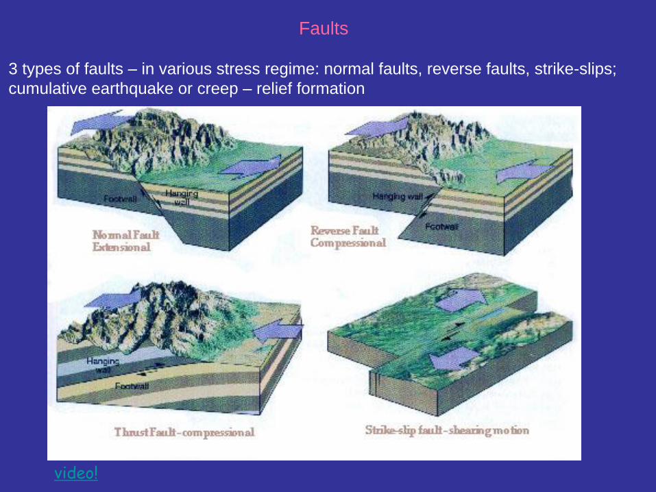
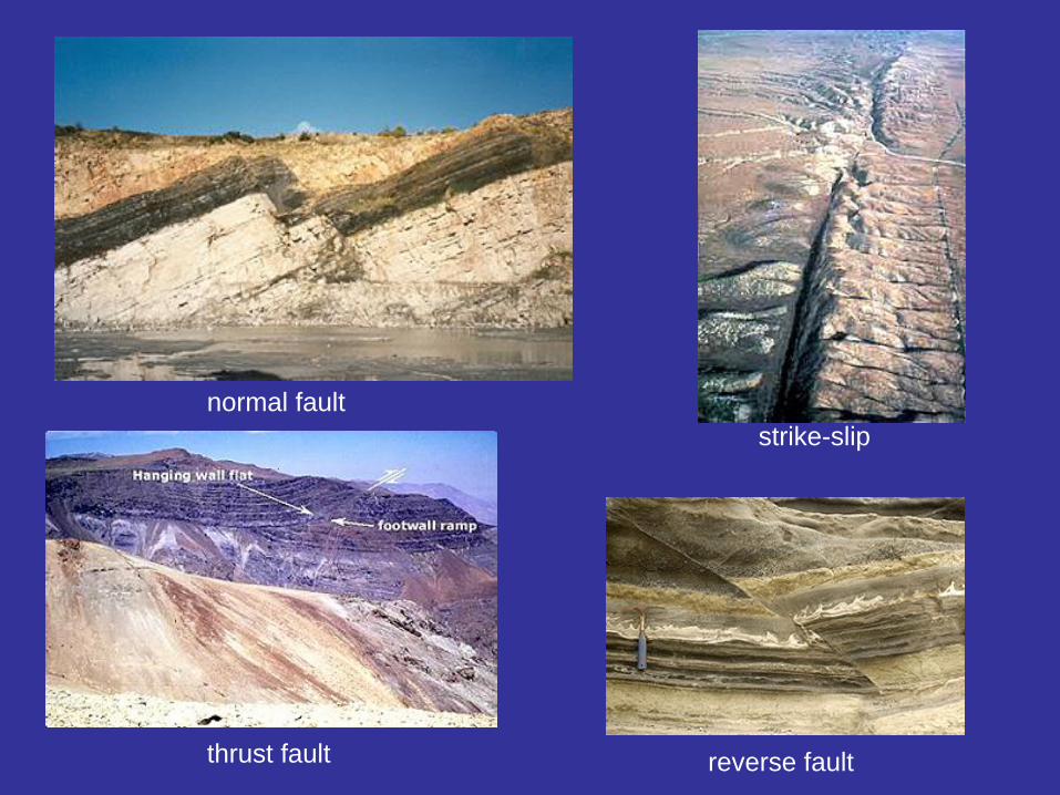
Faults
3 types of faults – in various stress regime: normal faults, reverse faults, strike-slips;
cumulative earthquake or creep – relief formation
video!

normal fault
reverse fault thrust fault
strike-slip

Landforms related to different types of
movements
Some features indicate the presence of a fault, but say little about
activity or type of movements
Vegetation alignments, springs, fault scarps, other lineaments
Change in landscape caused by change in landscape
process
Look for morphological anomalies – surfaces warped, tilted,
uplifted, fractured
Faults
3 types of faults – in various stress regime: normal faults, reverse faults, strike-slips;
cumulative earthquake or creep – relief formation
video!
normal fault
reverse fault thrust fault
strike-slip

Gilman Hot Springs, San Jacinto Valley
All Fault Types Have Potential to Disrupt Groundwater
Flow/Create Scarps
• Springs – fault gouge can be an effective barrier

• Vegetation Lineaments (arid areas)
San Andreas Fault -Thousand Palms Oasis, Indio Hills, California
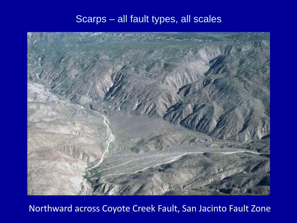
Scarps – all fault types, all scales
Northward across Coyote Creek Fault, San Jacinto Fault Zone

Carboneras fault, Spain
A young scarp!! TINY!
Scarp on Strike-Slip (oblique slip)
Coyote Mts, Elsinore
fault, CA

Scarps on normal fault
Krupnik fault , Bulgary, 1904 M=7,8
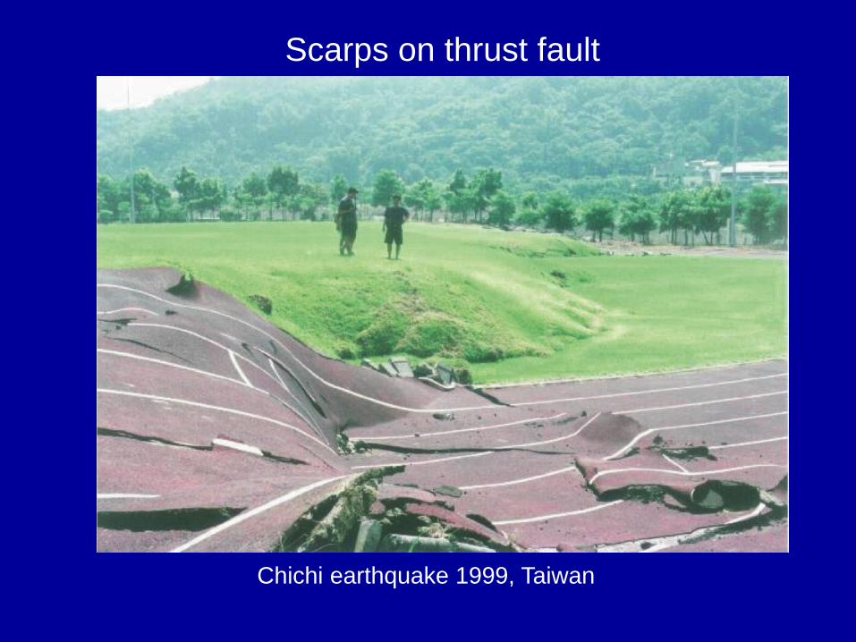
Scarps on thrust fault
Chichi earthquake 1999, Taiwan

Active or Inactive?
• Differential weathering along inactive faults can
produce features that resemble features
produced by active faults
– Vegetation lineaments,
– Linear valleys
– Scarps
• Known as
“Fault-Line Scarps”
Sometimes these features exist, but they are not associated with any active faulting!! (differential erosion)
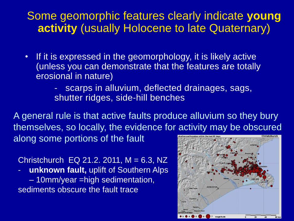
Some geomorphic features clearly indicate young activity (usually Holocene to late Quaternary)
• If it is expressed in the geomorphology, it is likely active
(unless you can demonstrate that the features are totally erosional in nature)
- scarps in alluvium, deflected drainages, sags, shutter ridges, side-hill benches
Christchurch EQ 21.2. 2011, M = 6.3, NZ
- unknown fault, uplift of Southern Alps
– 10mm/year =high sedimentation,
sediments obscure the fault trace
A general rule is that active faults produce alluvium so they bury themselves, so locally, the evidence for activity may be obscured
along some portions of the fault

Active Strike-Slip Fault Geomorphology
Burbank and Anderson, 2001

Effects on Stream Channels
Offsets • Implies a previously straight,
now-curved channel as a
result of displacement
• the bend in the channel
must agree with the sense
of slip!
Deflections • The curve in the channel
can be with or against the
sense of slip
• Result of drainage capture
– (water will take the easiest
path downhill, alluvial fans)
All offsets are deflections, but not all deflections are offsets!
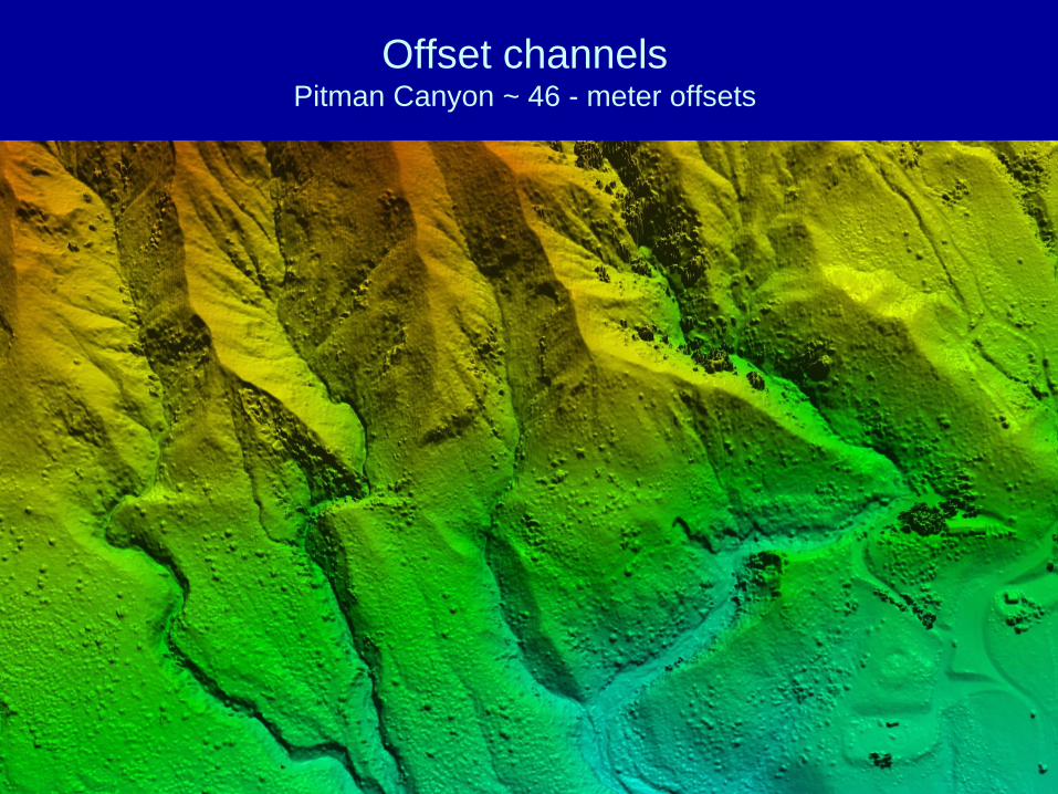
Offset channels Pitman Canyon ~ 46 - meter offsets

San Andreas Fault,
Carrizo plain, CA
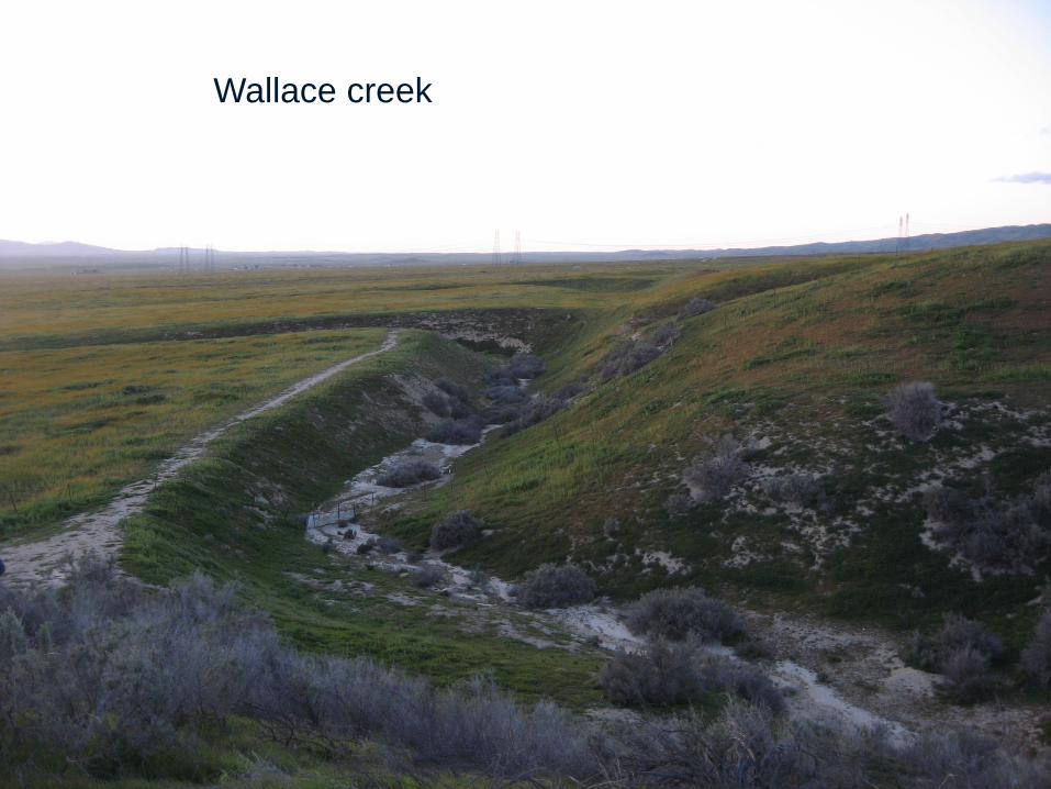
Wallace creek
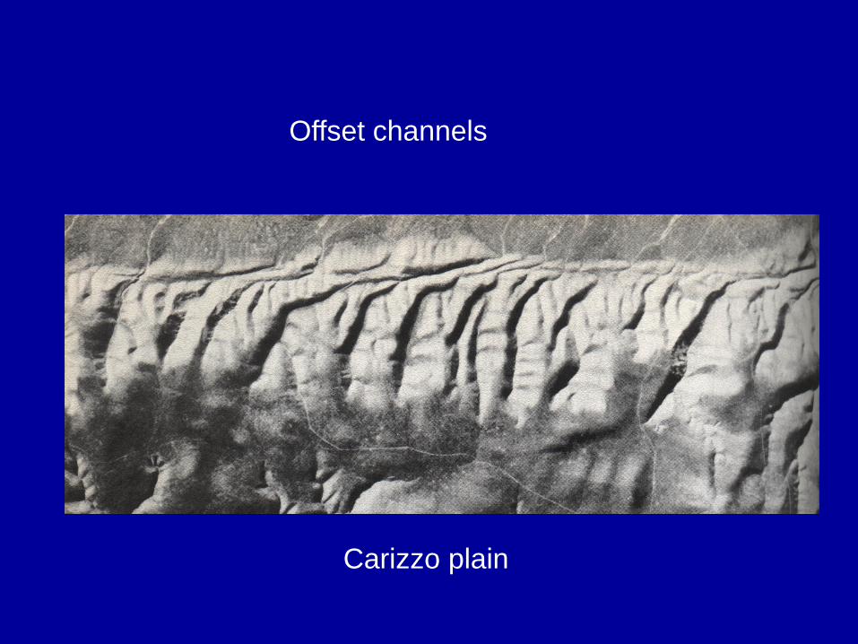
Offset channels
Carizzo plain

Elsinore fault

0 40 km
Coyote Mts
0 10 km
Coyote Mts
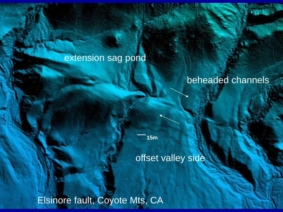
extension sag pond
offset valley side
beheaded channels
15m
Elsinore fault, Coyote Mts, CA

15m
beheaded channels
5-8m cumulative slip
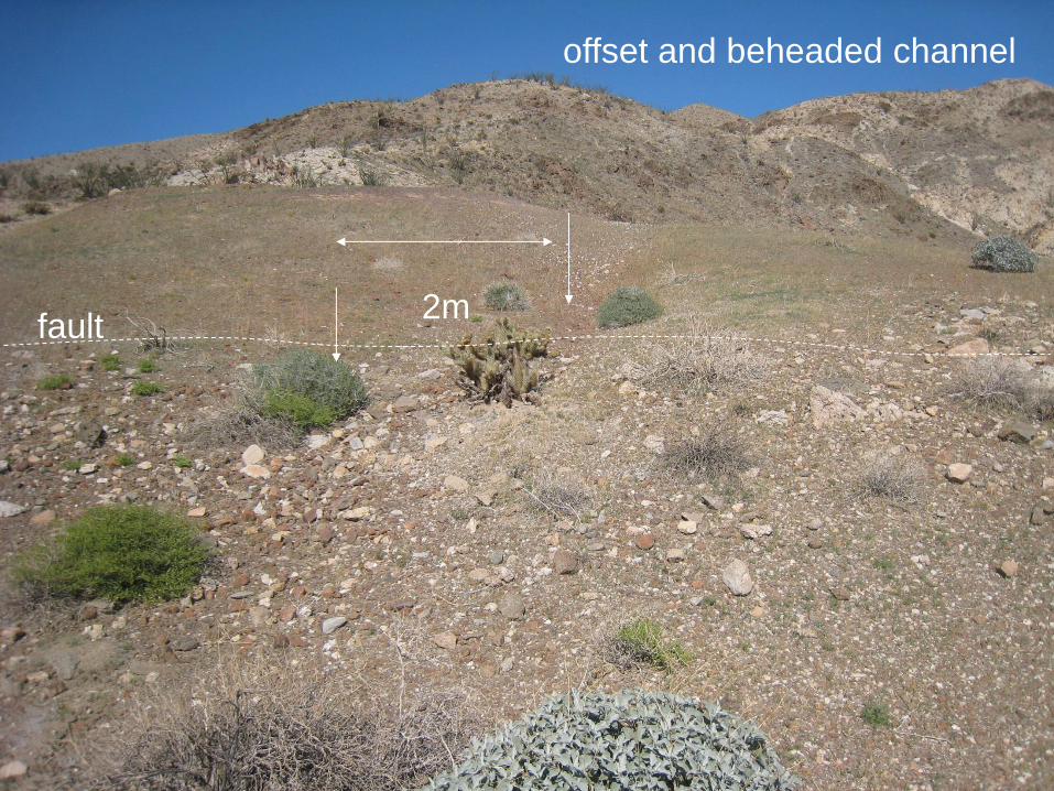
offset and beheaded channel
2m fault

0 500 m
Offset alluvial fans
Elsinore fault, Coyote Mts, CA

Alverson canyon, offset valley side
0 40 m
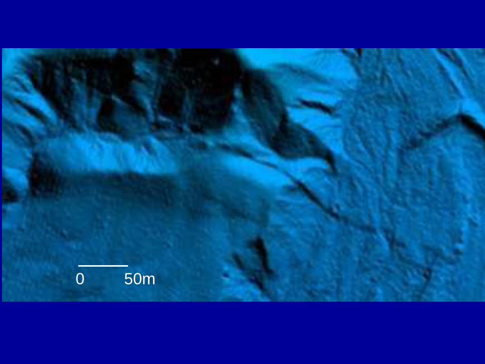
0 50m

offset channels and bars
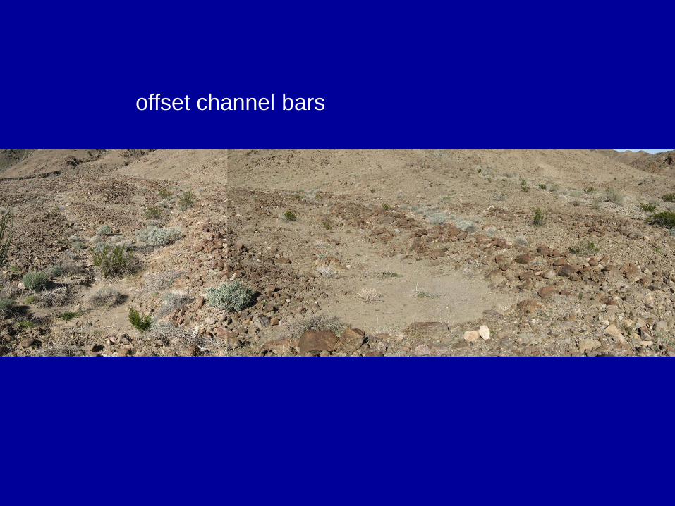
offset channel bars

offset alluvial fan

150m
offset alluvial fan
Different lithology – tells us about the amount of offset
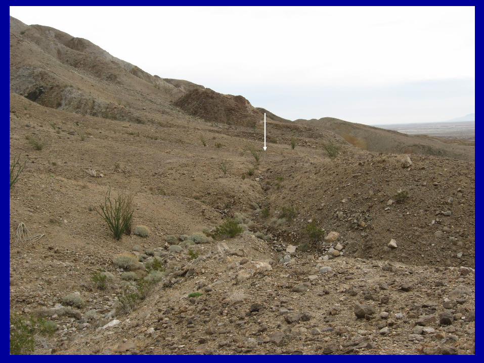

offset channel
Laguna Salada fault, 2010, M= 7.2 El Mayor

offset channel
offset valley side
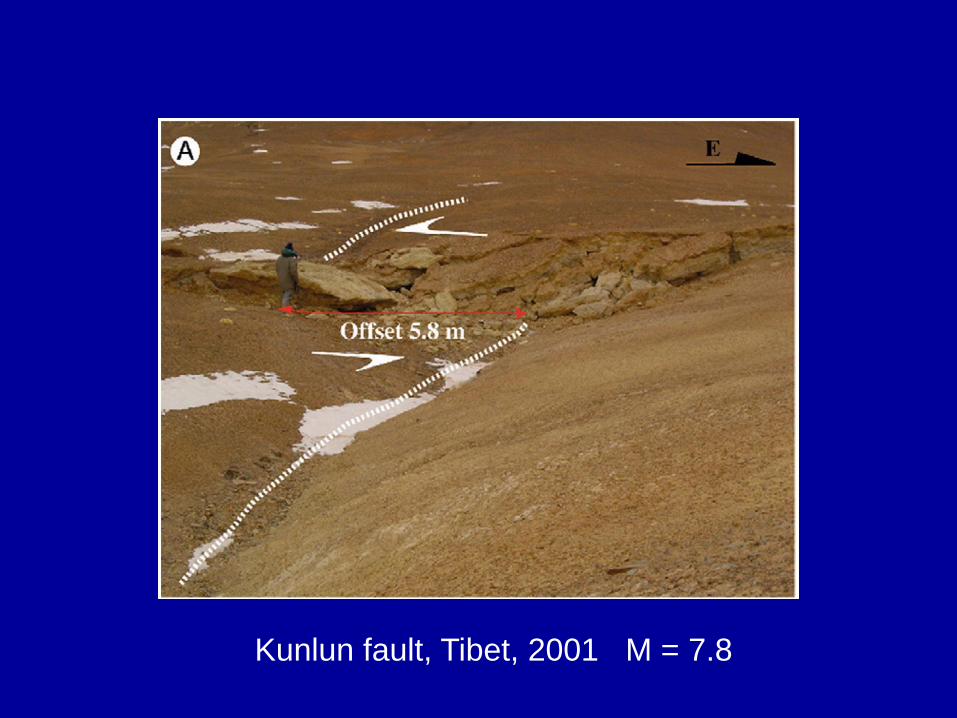
Kunlun fault, Tibet, 2001 M = 7.8

San Jacinto Fault, Southern California
Offset Channel
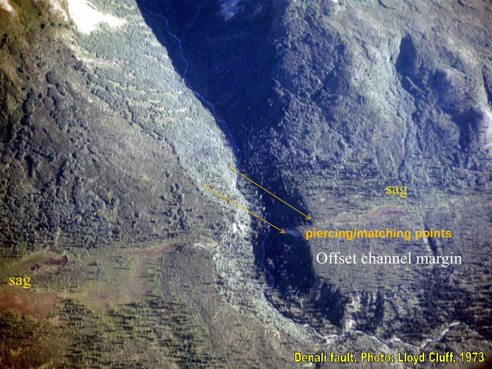
sag
sag
Offset channel margin
piercing/matching points

Shutter Ridge
• Hřbet, který se pohyboval podél horizontálního
zlomu a zablokoval odtok, údolí
Drainage Shutter Ridge(s) blocking drainage
Clark strand of the San Jacinto

Hector Mine Rupture, 1999

San Jacinto Fault, Southern California
Shutter Ridge(s)

Linear valleys
Linear valleys - related to faulting or just
fault-line eroding crushed fault zone rocks

Transtension/Transpression
Transtension
• Simultaneous occurrence
of strike-slip faulting and
extension
Transpression
• Simultaneous occurrence
of strike-slip faulting and
shortening
•Both occur at all scales! Local to regional features
•Controlled by bends in SS fault (local), or overall
convergence/divergence along a SS fault (regional)

Transtension • Component of divergence along SS fault (strike-slip)
• Right steps in Dextral SS fault
• Left steps in Sinistral SS fault
Opening causes a “sag,” or pull-apart basin

San Andreas
Sag Ponds
Topographic depression
produced by extensional bends
or stepovers along a strike-slip
fault. It may or may not contain
water year-round. Synonymous
with pull-apart basin.

Transpression
• Component of convergence along SS fault
• Left step in Dextral SS fault
• Right step in Sinistral SS Fault
Right-step causes a space problem, and a “pressure ridge” is
formed

Small pressure ridge along SAF in Cholame Valley
Pressure ridge
A topographic ridge produced by compressional bends or
stepovers along a strike-slip fault

Dragon’s Back Pressure Ridge System along the San Andreas
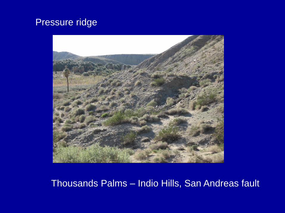
Thousands Palms – Indio Hills, San Andreas fault
Pressure ridge

Kunlun fault, Tibet, 2001 M = 7.8
„Mole track“ structure
Material is extruded along the
fault by pressure
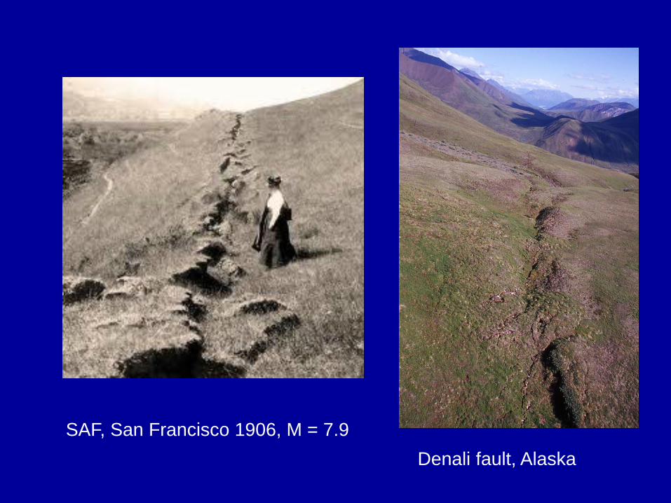
SAF, San Francisco 1906, M = 7.9
Denali fault, Alaska
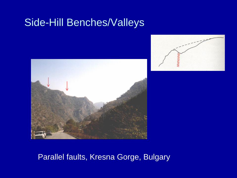
Side-Hill Benches/Valleys
Parallel faults, Kresna Gorge, Bulgary

Slope inflection along San Andreas Fault
Flat step on the slope
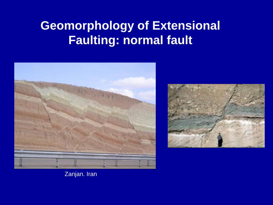
Geomorphology of Extensional
Faulting: normal fault
Zanjan. Iran
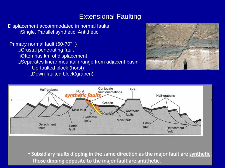
Extensional Faulting
Displacement accommodated in normal faults
Single, Parallel synthetic, Antithetic
Primary normal fault (60-70°)
Crustal penetrating fault
Often has km of displacement
Separates linear mountain range from adjacent basin
Up-faulted block (horst)
Down-faulted block(graben)

Crustal extension and normal faults – related to the most
remarkable topography at regional scale
Rifts valleys
rift – elevated heatflow,
vertical compression,
horizontal extension
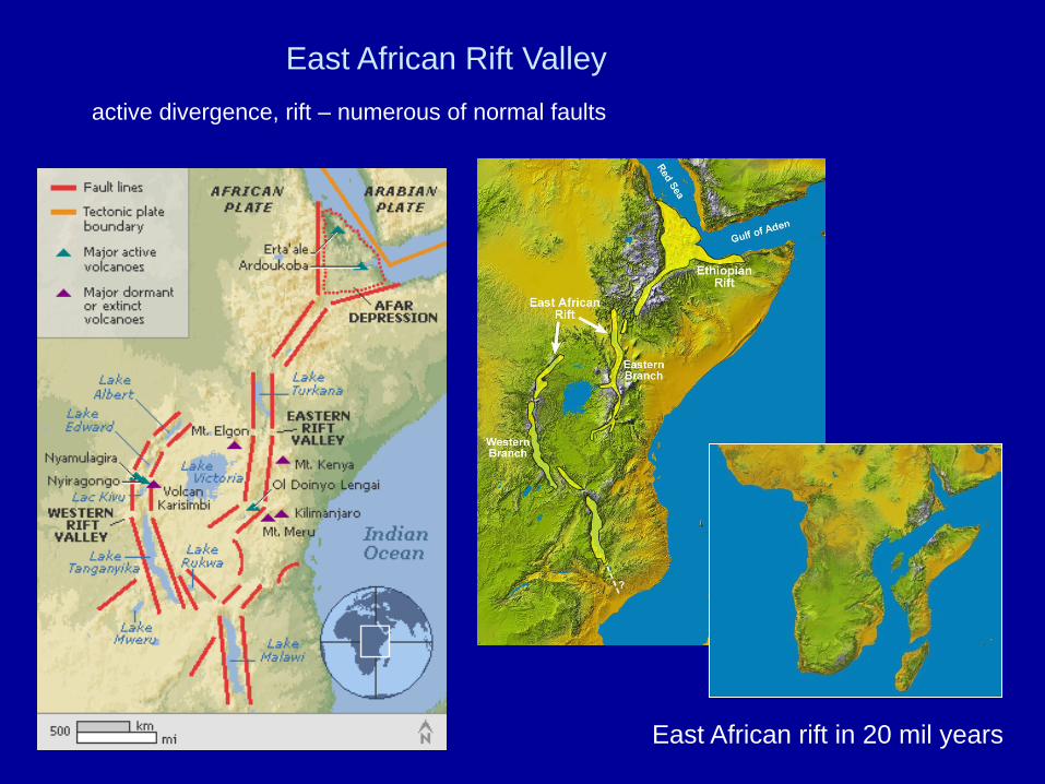
East African Rift Valley
East African rift in 20 mil years
active divergence, rift – numerous of normal faults
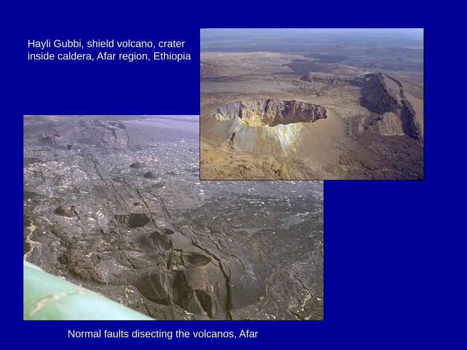
Hayli Gubbi, shield volcano, crater
inside caldera, Afar region, Ethiopia
Normal faults disecting the volcanos, Afar

Rift activity 2009
Massive fissure splits open in the
Ethiopian Desert
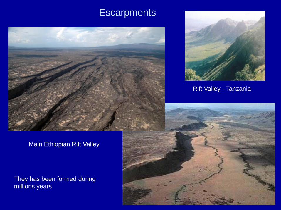
Main Ethiopian Rift Valley
Escarpments
Rift Valley - Tanzania
They has been formed during
millions years


Iceland - shaded area shows the Icelandic
Basalt Plateau, red points the migration of the
hot spot and orange lines are the rifts, both
active and inactive.
Iceland – Rift Valley
ridge represents submarine
segments of the mid-ocean ridge

Rift valley, Thingvellir national park, Iceland
Geological map of Iceland -
volcanic systems and volcanic
zones and the division of the island
into formations.
Each volcano with the
typical lifetime of 0.5-1.5
my. Around 30 active
volcanic systems in
Iceland.

Mid-Atlantic oceanic ridge
Ocean ridge – basaltic oceanic crust