Palen Class III final draft - California Energy Commission · Keywords: Archaeological Survey,...
200
Appendix G Palen Solar Power Project August 2009 APPENDIX G Cultural Resources Technical Report
Transcript of Palen Class III final draft - California Energy Commission · Keywords: Archaeological Survey,...

Appendix G
Palen Solar Power Project August 2009
APPENDIX G
Cultural Resources Technical Report

CULTURAL RESOURCES CLASS III REPORT FOR THE
PROPOSED PALEN SOLAR POWER PROJECT RIVERSIDE COUNTY, CALIFORNIA
Prepared for: Solar Millennium, LLC
and Chevron Energy Solutions
Prepared by: Matthew Tennyson, M.A., R.P.A.
Rebecca Apple, M.A., R.P.A.
With contributions by: James Cleland, Ph.D., R.P.A.
M.K. Meiser, M.A.
EDAW AECOM 1420 Kettner Boulevard, Suite 500
San Diego, California 92101 (619) 233-1454
August 2009
USGS Quadrangle: Corn Spring, Sidewinder Well 7.5"
Keywords: Archaeological Survey, Architectural Survey, Riverside County, Bureau of Land Management, California Energy Commission

Solar Millennium Palen Cultural Resources Class III Technical Report Page i Palen Class III final draft .doc 8/13/2009
TABLE OF CONTENTS Section Page
EXECUTIVE SUMMARY .......................................................................................................... vii
CHAPTER 1 – INTRODUCTION ................................................................................................ 1 Project Description ................................................................................................................ 1 Regulatory Setting ................................................................................................................. 1
LORS ............................................................................................................................ 5 Federal LORS ...................................................................................................... 7 State LORS .......................................................................................................... 8 Local LORS ....................................................................................................... 11
Area of Potential Effects (APE)........................................................................................... 12 Project Personnel ................................................................................................................. 12 Report Organization............................................................................................................. 13
CHAPTER 2 – PROJECT SETTING.......................................................................................... 15 Natural Context.................................................................................................................... 15
Physiography and Geology......................................................................................... 15 Climate................................................................................................................................. 19
Temperature ................................................................................................................ 19 Precipitation ................................................................................................................ 19
Vegetation (Modern/Holocene) ........................................................................................... 20 Fauna (Modern/Holocene)................................................................................................... 21 Holocene Climate Change ................................................................................................... 22
Terminal Wisconsin to Middle Holocene ................................................................... 22 Late Holocene ............................................................................................................. 23
Cultural Context................................................................................................................... 24 Prehistory .................................................................................................................... 24 Malpais Pattern ........................................................................................................... 24 Paleoindian Period ...................................................................................................... 24 Archaic Period ............................................................................................................ 25 Late Prehistoric Period................................................................................................ 26 Ethnographic Background .......................................................................................... 27
Quechan ............................................................................................................. 28 Halchidhoma...................................................................................................... 28 Mohave .............................................................................................................. 28 Chemehuevi ....................................................................................................... 29 Desert Cahuilla .................................................................................................. 29
History......................................................................................................................... 30 Early Exploration ........................................................................................................ 30 Regional Development................................................................................................ 31 Transportation ............................................................................................................. 32 Mining......................................................................................................................... 33

Solar Millennium Palen Cultural Resources Class III Technical Report Page ii Palen Class III final draft .doc 8/13/2009
Military Training Activities ........................................................................................ 34 Desert Training Center (DTC)........................................................................... 35 Desert Strike ...................................................................................................... 36
Agriculture/Ranching.................................................................................................. 37
CHAPTER 3 – ARCHIVAL RESEARCH AND CONTACT PROGRAM ............................... 39 Records Search .................................................................................................................... 39
Previous Surveys......................................................................................................... 39 Previously Recorded Sites .......................................................................................... 40
Other Archival Research...................................................................................................... 41 Historic Maps.............................................................................................................. 42 Museums and Historical Societies .............................................................................. 42 BLM Archives ............................................................................................................ 43
Contact Program .................................................................................................................. 43 Native American Contact Program............................................................................. 43 Historical Society Contact Program............................................................................ 45 Agency Contacts ......................................................................................................... 46
Permits Required................................................................................................ 46
CHAPTER 4 – METHODS......................................................................................................... 47 Survey Methodology ........................................................................................................... 47
Documentation............................................................................................................ 48 Site Types ............................................................................................................................ 48
Prehistoric ................................................................................................................... 48 Trails .................................................................................................................. 48 Lithic Scatters and Flaking Stations .................................................................. 48 Ceramic Scatters and Pot Drops ........................................................................ 49 Cleared Circles................................................................................................... 49 Rock Rings......................................................................................................... 49 Prehistoric Cairns............................................................................................... 49 Habitation Sites.................................................................................................. 50 Petroglyphs ........................................................................................................ 50 Ground Figures – Geoglyphs and Rock Alignments ......................................... 50 Cremations/Human Remains ............................................................................. 50 Groundstone Quarries and Groundstone Tools ................................................. 50
Historic........................................................................................................................ 50 Transportation Routes........................................................................................ 51 Historic Camps .................................................................................................. 51 Refuse Scatters and Dumps ............................................................................... 51 Historic Cairns ................................................................................................... 51
Isolated Finds .............................................................................................................. 51 Research Issues and Themes................................................................................................ 51
Prehistoric Research Themes...................................................................................... 51 Chronology ........................................................................................................ 52 Prehistoric Settlement ........................................................................................ 52 Lithic Technology.............................................................................................. 53

Solar Millennium Palen Cultural Resources Class III Technical Report Page iii Palen Class III final draft .doc 8/13/2009
Historic Research Themes .......................................................................................... 54
CHAPTER 5 – ARCHAEOLOGICAL RESULTS ..................................................................... 57 Site Descriptions and Significance Assessments........................................................ 58
SMP-H-1001...................................................................................................... 58 SMP-H-1002...................................................................................................... 59 SMP-H-1003...................................................................................................... 61 SMP-H-1004...................................................................................................... 62 SMP-H-1005...................................................................................................... 63 SMP-H-1006...................................................................................................... 65 SMP-H-1007...................................................................................................... 66 SMP-H-1008...................................................................................................... 67 SMP-H-1009...................................................................................................... 68 SMP-H-1010...................................................................................................... 69 SMP-H-1011...................................................................................................... 70 SMP-H-1012...................................................................................................... 71 SMP-H-1013...................................................................................................... 72 SMP-P-1015 ...................................................................................................... 73 SMP-P-1016 ...................................................................................................... 74 SMP-P-1017 ...................................................................................................... 75 SMP-P-1018 ...................................................................................................... 76 SMP-P-1019A.................................................................................................... 78 SMP-P-1019B.................................................................................................... 79 SMP-H-1020...................................................................................................... 80 SMP-H-1021...................................................................................................... 81 SMP-H-1022...................................................................................................... 82 SMP-H-1023...................................................................................................... 83 SMP-H-1024...................................................................................................... 84 SMP-H-1025...................................................................................................... 85 SMP-H-1026...................................................................................................... 86 SMP-H-1027...................................................................................................... 87 SMP-H-1032...................................................................................................... 87 SMP-H-2002...................................................................................................... 88 SMP-H-2003...................................................................................................... 89 SMP-H-2004...................................................................................................... 90 SMP-H-2006...................................................................................................... 91 SMP-H-2007...................................................................................................... 92 SMP-H-2008...................................................................................................... 93 SMP-H-2009...................................................................................................... 93 SMP-H-2010...................................................................................................... 94 SMP-H-2011/2012............................................................................................. 96 SMP-P-2013A.................................................................................................... 99 SMP-P-2013B.................................................................................................... 99 SMP-P-2014 .................................................................................................... 100 SMP-P-2015 .................................................................................................... 102

Solar Millennium Palen Cultural Resources Class III Technical Report Page iv Palen Class III final draft .doc 8/13/2009
SMP-H-2016.................................................................................................... 103 SMP-H-2017.................................................................................................... 105 SMP-P-2018 .................................................................................................... 105 SMP-H-2019.................................................................................................... 107 SMP-H-2020.................................................................................................... 108 SMP-H-2021.................................................................................................... 108 SMP-H-2022.................................................................................................... 110 SMP-P-2023 .................................................................................................... 111 SMP-H-RMA-1 ............................................................................................... 112
Isolated Finds ............................................................................................................ 113 Discussion.......................................................................................................................... 121
CHAPTER 6 – SUMMARY AND MANAGEMENT RECOMMENDATIONS .................... 126 Summary............................................................................................................................ 126
Recommendations for Archaeological Resources .................................................... 131
CHAPTER 7 – REFERENCES ................................................................................................. 132 ATTACHMENTS 1 Resumes 2 Records Search (Confidential) 3 Contact Program (Confidential) 4 Project Maps (Confidential) 5 DPR Site Forms (Confidential) 6 Architectural Survey Report (Confidential)

Solar Millennium Palen Cultural Resources Class III Technical Report Page v Palen Class III final draft .doc 8/13/2009
LIST OF FIGURES Figure Page 1 Regional Setting of the Project Area .................................................................................. 2 2a Project Area ........................................................................................................................ 3 2b Project Area ........................................................................................................................ 4 3 Dikes South of the Project Area...................................................................................... 123
LIST OF PLATES Plate Page 1 Patinated desert pavement................................................................................................. 16 2 Rocky alluvial sediments .................................................................................................. 17 3 Ephemeral drainage .......................................................................................................... 18 4 Sand dunes ........................................................................................................................ 18 5 Dune to playa transition .................................................................................................... 19 6 SMP-H-1002 facing north................................................................................................. 60 7 SMP-H-1005 facing the east............................................................................................. 63 8 SMP-P-1015 facing south-southwest................................................................................ 73 9 SMP-P-1016 facing west .................................................................................................. 74 10 Hearth feature at SMP-P-1017.......................................................................................... 76 11 Hearth feature at SMP-P-1018.......................................................................................... 77 12 SMP-P-1019a facing west................................................................................................. 78 13 SMP-P-1019b facing north ............................................................................................... 79 14 Wooden pole at SMP-H-1024........................................................................................... 84 15 SMP-H-1026 facing east................................................................................................... 86 16 Tank tracks at SMP-H-2009 ............................................................................................. 94 17 Pocketknife at SMP-H-2011/2012.................................................................................... 97 18 Sparkplug at SMP-H-2011/2012....................................................................................... 98 19 FAR at site SMP-P-2013B.............................................................................................. 100 2 SMP-P-2015 facing southeast......................................................................................... 102 21 SMP-H-2016 facing north............................................................................................... 104 22 SMP-P-2018 facing south ............................................................................................... 106 23 X-cut can at SMP-H-2021 .............................................................................................. 109 24 FAR at SMP-P-2023....................................................................................................... 111
Solar Millennium Palen Cultural Resources Class III Technical Report Page vi Palen Class III final draft .doc 8/13/2009
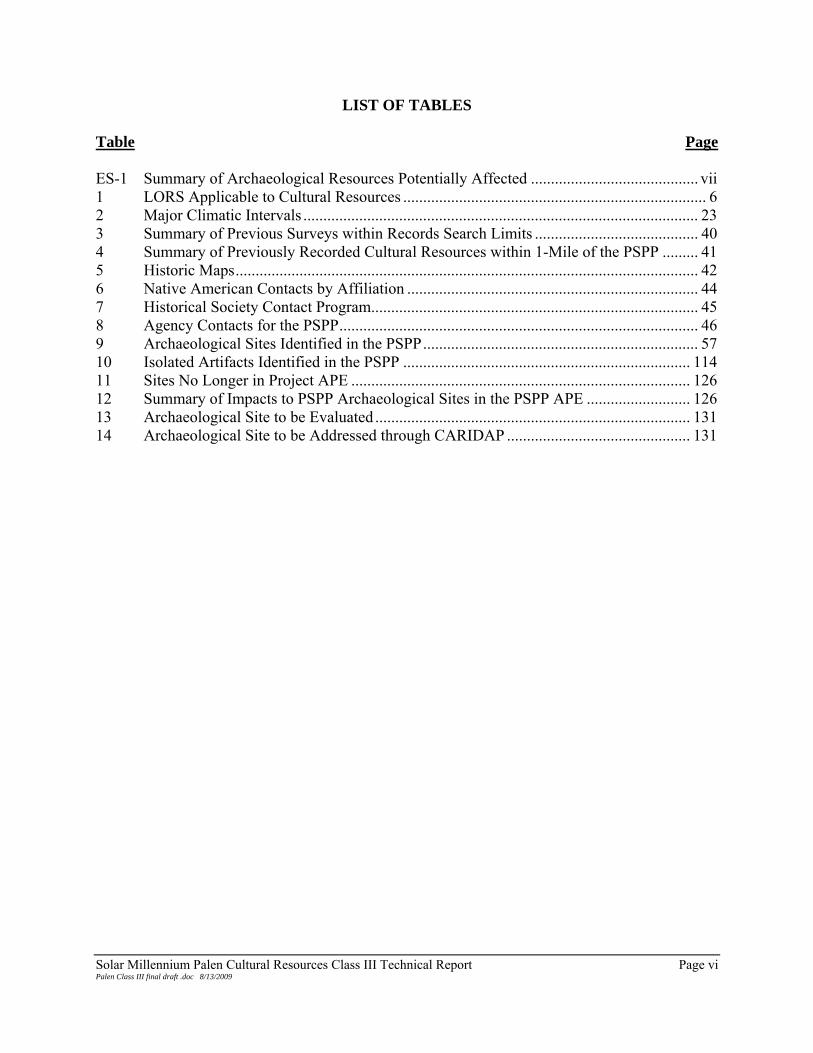
LIST OF TABLES Table Page ES-1 Summary of Archaeological Resources Potentially Affected .......................................... vii 1 LORS Applicable to Cultural Resources ............................................................................ 6 2 Major Climatic Intervals ................................................................................................... 23 3 Summary of Previous Surveys within Records Search Limits ......................................... 40 4 Summary of Previously Recorded Cultural Resources within 1-Mile of the PSPP ......... 41 5 Historic Maps.................................................................................................................... 42 6 Native American Contacts by Affiliation ......................................................................... 44 7 Historical Society Contact Program.................................................................................. 45 8 Agency Contacts for the PSPP.......................................................................................... 46 9 Archaeological Sites Identified in the PSPP..................................................................... 57 10 Isolated Artifacts Identified in the PSPP ........................................................................ 114 11 Sites No Longer in Project APE ..................................................................................... 126 12 Summary of Impacts to PSPP Archaeological Sites in the PSPP APE .......................... 126 13 Archaeological Site to be Evaluated ............................................................................... 131 14 Archaeological Site to be Addressed through CARIDAP .............................................. 131

Solar Millennium Palen Cultural Resources Class III Technical Report Page vii Palen Class III final draft .doc 8/13/2009
EXECUTIVE SUMMARY Solar Millennium, LLC and Chevron Energy Solutions (the Applicants) are proposing to construct a solar electric generating facility called the Palen Solar Power Project (PSPP or Project) in eastern Riverside County, California. To meet applicable regulatory requirements an archaeological resources survey and a built environment survey were conducted of the Project site and buffer zones. As a thermal power plant over 50 megawatts (MW) proposed on public lands managed by the Bureau of Land Management (BLM), the project is undergoing review by both the California Energy Commission (CEC) and BLM and the two agencies are conducting a combined review. The cultural resources work was conducted under BLM Cultural Use Permit (CA-06-21) and a BLM Fieldwork Authorization dated March 10, 2009. This report addresses the inventory and significance of cultural resources identified within the PSPP. Fieldwork was conducted between April 13 and May 6, 2009. Surveys were undertaken to determine what cultural resources are present in the Project area and buffer and to determine potential Project impacts on these resources. Prior to the fieldwork, archival research was conducted, including a records search to determine if there were any previously recorded sites present within the Project area. In addition, to meet CEC requirements for preparation of an Application for Certification (AFC), local historical societies, the Native American Heritage Commission, and local tribal representatives were contacted for input. The survey of the built environment identified five resources (see Attachment 6 to this report). The archaeological survey identified 50 sites and 330 isolated finds. Based on changes to the Project that occurred subsequent to the survey, four of the archaeological sites and 42 of the isolates are no longer within the Project site or buffer. Five sites are located in the buffers and were not evaluated for inclusion to the California Register of Historical Resources (CRHR) or the National Register of Historic Places (NRHP). Of the 46 sites on the Project site that potentially could be affected, nine are prehistoric sites and 37 are historic sites. The historic period sites are primarily historic debris scatters containing combinations of glass, metal and ceramics. Historic artifacts include solder-top cans, square cans, side-seam cans, and broken bottles. The prehistoric cultural resources consisted of lithic scatters of varying sizes, including flakes, cores, groundstone, ceramic, clusters of fire-affected rock, and temporary camps. Assessments of the archaeological sites based on surface materials and conditions indicate that six of the sites are potentially eligible for the CRHR under Criterion 4 and are unevaluated for the NRHP under Criterion D. Table ES-1 summarizes the identified archaeological resources and their status. Subsurface investigations will be required to determine the significance of the identified resources under Section 106 of the National Historic Preservation Act. Table ES-1. Summary of Archaeological Resources Potentially Affected
Total Potentially Eligible Not Eligible Not Evaluated Prehistoric 9 6 0 3 Historic 37 0 35 2 Isolated Finds 288 0 288 0

Solar Millennium Palen Cultural Resources Class III Technical Report Page 1 Palen Class III final draft .doc 8/13/2009
CHAPTER 1 – INTRODUCTION
PROJECT DESCRIPTION Solar Millennium LLC and Chevron Energy Solutions (the Applicants) are proposing to develop the Palen Solar Power Project (PSPP or Project), a solar thermal power generating facility with a capacity of 500 megawatts (MW) in eastern Riverside County, California (Figure 1 and Figure 2). EDAW AECOM (EDAW) has been retained to conduct cultural resources studies, including archaeological and architectural surveys for the Project. As a thermal power plant over 50 megawatts (MW) proposed on public lands managed by the Bureau of Land Management (BLM), the project is undergoing review by both the California Energy Commission (CEC) and BLM and the two agencies are conducting a combined review. Thus, this report is intended to support compliance with both the California Environmental Quality Act (CEQA) and the National Environmental Policy Act (NEPA). The Applicants have applied for a BLM Right-of-Way (ROW) grant totaling approximately 5,200 acres within which the area that will be disturbed during construction and operation will be approximately 3,870 acres. The culturally-sensitive Palen Dry Lake is located less than 1 kilometer (km) (0.6 miles) to the north of the northern edge of the ROW, although the area that will be disturbed by Project activities is in the southern portions of the ROW, the area furthest from the dry lake.. The PSPP plant site and its general environs are essentially undeveloped. The site is relatively flat, with elevations ranging from approximately 700 ft above mean sea level (amsl) in the southwest to 425 ft amsl in the northeast. Palen will use parabolic trough solar thermal technology to concentrate the sun’s energy on a linear receiver located at the center point of each parabolic solar subarray. Energy collected in the array is used to generate steam, driving a turbine that generates electricity. The route of the transmission line that will interconnect the Project with the regional grid has not yet been finalized and thus no cultural resources investigation has been performed to date. When the route is finalized, the needed cultural resources investigation will be conducted and the results provided to the regulatory agencies and other stakeholders. REGULATORY SETTING Cultural resources were assessed for eligibility for inclusion in the California Register of Historical Resources (CRHR) and the National Register of Historical Places (NRHP). Cultural resources are defined as buildings, sites, structures, or objects, each of which may have historical, architectural, archaeological, cultural, and/or scientific importance. For listing in the CRHR a historical resource must be significant at the local, state or national level under one or more of the following four criteria:
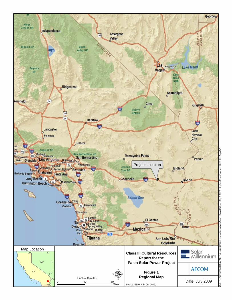
Source: ESRI; AECOM 2009;
Class III Cultural ResourcesReport for the
Palen Solar Power Project
Figure 1Regional Map
LEGEND
CA
NV
AZ
UT
OR IDMap Location
Date: July 2009
Path
: P:\2
009\
0908
0081
Sol
Mil
Pale
n\6.
0 G
IS\6
.3 L
ayou
t\Rep
orts
\Cul
tura
l Cla
ss II
I Rep
ort\F
ig 1
_PSP
P_Re
gion
alLo
catio
n.m
xd,
07/2
9/09
, Au
gello
P
µ
Project Location
Blythe
0 40 80Miles
1 inch = 40 miles

Source: NAIP, 2005; USGS; AECOM 2009
Class III Cultural ResourcesReport for the
Palen Solar Power Project
Figure 2aProject Area
LEGEND
Map Location
Date: August 2009
Legend
Palen Dry Lake
Match Line Match Line
0 2,000 4,000Feet
1 inch = 2,000 feet
Facility FootprintArchaeological Survey Area µ
Path
: P:\2
009\
0908
0081
Sol
Mil
Pale
n\6.
0 G
IS\6
.3 L
ayou
t\Rep
orts
\Cul
tura
l Cla
ss II
I Rep
ort\F
ig 2
pro
ject
are
a.m
xd,
08/1
0/09
, St
einB
CA
NV
AZ
UT
OR ID

Source: NAIP, 2005; USGS; AECOM 2009
Class III Cultural ResourcesReport for the
Palen Solar Power Project
Figure 2bProject Area
LEGEND
Map Location
Date: August 2009
Legend
Match Line Match Line
0 2,000 4,000Feet
1 inch = 2,000 feet
Facility FootprintArchaeological Survey Area µ
Path
: P:\2
009\
0908
0081
Sol
Mil
Pale
n\6.
0 G
IS\6
.3 L
ayou
t\Rep
orts
\Cul
tura
l Cla
ss II
I Rep
ort\F
ig 2
pro
ject
are
a.m
xd,
08/1
0/09
, St
einB
CA
NV
AZ
UT
OR ID

Solar Millennium Palen Cultural Resources Class III Technical Report Page 5 Palen Class III final draft .doc 8/13/2009
1. It is associated with events that have made a significant contribution to the broad patterns of local or regional history, or the cultural heritage of California or the United States;
2. It is associated with the lives of persons important to local, California or national history;
3. It embodies the distinctive characteristics of a type, period, region or method of construction, or represents the work of a master or possesses high artistic values;
4. It has yielded or has the potential to yield information important to the prehistory or history of the local area, California or the nation.
For listing in the NRHP, a historical resource must be significant at the local, state or national level under one or more of the following four criteria:
A. That are associated with events that have made a significant contribution to the broad patterns of our history;
B. That are associated with the lives of persons significant in our past;
C. That embody the distinctive characteristics of a type, period, or method of construction, or that represent the work of a master, or that possess high artistic values, or that represent a significant and distinguishable entity whose components may lack individual distinction;
D. That has yielded or may be likely to yield, information important in prehistory or history.
All resources nominated for listing must have integrity, which is the authenticity of a historical resource’s physical identity evidenced by the survival of characteristics that existed during the resource’s period of significance. Resources, therefore, must retain enough of their historic character or appearance to be recognizable as historical resources and to convey the reasons for their significance. Integrity is evaluated with regard to the retention of location, design, setting, materials, workmanship, feeling and association. It must also be judged with reference to the particular criteria under which a resource is proposed for nomination. LORS Numerous laws, ordinances, regulations, and standards (LORS), on federal, state and local levels, seek to protect and target the management of cultural resources. The PSPP will comply with applicable LORS throughout construction and operation. Applicable LORS are summarized in Table 1 and briefly discussed below.

Solar Millennium Palen Cultural Resources Class III Technical Report Page 6 Palen Class III final draft .doc 8/13/2009
Table 1. LORS Applicable to Cultural Resources Laws Applicability Federal Antiquities Act of 1906, Title 16 United States Code, Sections 431-433
Federal legislation for protection of cultural resources on federal land
National Historic Preservation Act (NHPA), Title 16 United States Code Section 470 et seq.
Establishes national policy of historic preservation; requires that Federal agencies consider significant cultural resources prior to undertakings.
Archaeological Resources Protection Act of 1979, Title 16 United States Code Sections 470aa-470mm
Provides protection for archaeological resources on public lands and Indian lands
Executive Order 11593 of May 13, 1971, 36 Federal Register (FR) 8921
Provides for protection and enhancement of the cultural environment
Secretary of Interior’s Standards for Archaeology and Historic Preservation 48 FR 44716-42
Establishes guidelines for technical reports and standards for evaluation for State Historic Preservation Office
Federal Land Policy Management Act of 1976 Sections 1710 (a)(8) and 1740
Establishes that public lands be managed in a manner that will protect the quality of scientific, scenic, historical, …and archeological values.
Native American Graves Protection and Repatriation Act, Title 25, United States Code Sections 3001-3013
This law provides for ownership of Native American graves and grave goods on federal lands..
American Indian Religious Freedom Act, Title 42 United States Code Section 1996
Provides protection of Native American religious practices
State California Environmental Quality Act (CEQA), Public Resources Code Section 21083.2
Requires public agencies to evaluate impacts to cultural resources; provides guidance for evaluating and mitigating impacts.
CEQA Guidelines, California Code of Regulations Title 14 Sections 15064.5, 10564.7, 105126.4(b), Appendix G Section V
Addresses reburial options for Native American remains and provides for treatment of archaeological discoveries. Encourages agencies to develop thresholds of significance to determine the significance of environmental effects Outlines mitigation measures related to impacts on historical resources. Environmental checklist for identifying potential disturbances to cultural resources
Public Resources Code Sections 5024.1, 5097.98, 5097.99, 5097.991, and 21084.1
Establishes the California Register of Historical Resources Discusses the procedures that need to be followed upon the discovery of Native American human remains. Establishes that removal of Native American grave artifacts or remains is a felony Establishes that it is the policy of the state to repatriate Native American grave artifacts Provides a definition of historical resources, and states that projects that cause a substantial adverse change in the significance of an historical resource are projects that may have a significant effect on the environment
Assembly Bill 2641 Modifies the process that private land owners follow after discovering Native American human remains (set forth in California Public Resources Code 5097.98).

Solar Millennium Palen Cultural Resources Class III Technical Report Page 7 Palen Class III final draft .doc 8/13/2009
Laws Applicability Health and Safety Code Sections 7050.5, and 8010-8011
Establishes procedures for notification in the event of the discovery of human remains. Requires construction to be halted and the County Coroner to be contacted if human remains are encountered. Makes it a misdemeanor to disturb or remove human remains found outside a cemetery.
Local Riverside County General Plan, Chapter 5 (Multipurpose Open Space [OS] Element), Policies OS 19.2-19.4
Provides that the County will promote the preservation of cultural resources and promote Native American consultation
Riverside County General Plan, Chapter 5 (Multipurpose Open Space [OS] Element), Policies OS 19.5-19.7
Provides historic structure evaluation and enforcement of the Historic Building Code during development projects
Riverside County General Plan, Exhibit A, CEQA Findings of Fact and Statement of Overriding Considerations, Section 4.7, Mitigation Monitoring Program, Measures 4.7.1A, 4.7.1B, and 4.7.1C
Outlines mitigation measures for cultural resources monitoring programs
Federal LORS Antiquities Act of 1906, Title 16 United States Code Sections 431 - 433. This Act establishes criminal penalties for unauthorized destruction or appropriation of “any historic or prehistoric ruin or monument, or any object of antiquity” on federal land. National Historic Preservation Act, Title 16 United States Code Section 470 et seq. The National Historic Preservation Act (NHPA) sets in place a program for the preservation of historic properties. Section 106 of the NHPA requires federal agencies to take in to account the effects of projects on historic properties (resources included in or eligible for the NRHP. It also gives the Advisory Council on Historic Preservation and State Historic Preservation Offices (SHPO) an opportunity to consult. Federal agencies issuing permits for the PSPP would be required to comply with NHPA requirements. Archaeological Resources Protection Act of 1979, Title 16 United States Code Section 470aa-470mm. This Act provides protection of archaeological resources from vandalism and unauthorized collecting on federal land. Executive Order 11593 of May 13, 1971, 36 Federal Register (FR) 8921. This Executive Order focuses on the protection and enhancement of the cultural environment. It outlines responsibilities of the federal agencies and Secretary of the Interior with regard to cultural resources. Archeology and Historic Preservation: Secretary of Interior’s Standards and Guidelines 48 FR 44716-42. This document establishes standards and guidelines regarding professional qualification requirements for archaeological and historic preservation professionals, technical

Solar Millennium Palen Cultural Resources Class III Technical Report Page 8 Palen Class III final draft .doc 8/13/2009
report format and content, and standards for resource evaluation required by the State Historic Preservation Officer. Federal Land Policy Management Act of 1976 43 United States Code Section 1701 et seq. The Federal Land Policy Management Act (FLPMA) declares that it is the policy of the United States that public lands be managed so as to protect historical and archaeological resources, and that the Secretary of Interior shall establish rules and regulations regarding resource protection on public lands. Native American Graves Protection and Repatriation Act, Title 25 United States Code Sections 3001-3013. Provides for the protection of Native American graves, funerary objects, and “objects of cultural patrimony” on federal land and establishes the procedures for determining ownership for Native American human remains, funerary objects, and other sacred objects under federal jurisdiction American Indian Religious Freedom Act, Title 42 United States Code Section 1996. This measure establishes a national policy to protect the right of Native Americans and other indigenous groups to exercise their traditional religions. Federal agencies issuing permits for the PSPP would be required to comply with this Act if Native Americans identified issues regarding their right to exercise traditional religious practices. State LORS California Environmental Quality Act (CEQA), Public Resources Code Section 21083.2. Under CEQA, the lead agency is responsible for determining whether a project may have a significant effect on historical and archaeological resources. Section 21083.2 states that if the lead agency determines that the project may have a significant effect on “unique” archaeological resources, an environmental impact report shall address these resources. A unique archaeological resource is an artifact, object, or site about which it can be clearly demonstrated that, without merely adding to the current body of knowledge, there is a high probability that it meets one of the following criteria: (1) Contains information needed to answer important research questions and that there is a demonstrable public interest in that information; (2) Has a special and particular quality such as being the oldest or best example of its type; or (3) Is directly associated with a scientifically recognized important prehistoric or historic event or person. If it can be demonstrated that a project will cause damage to a unique archaeological resource, the lead agency may require that reasonable efforts be taken to preserve these resources in place or provide mitigation measures. CEC licensing is a CEQA-equivalent process. CEQA Guidelines, California Code of Regulations Title 14 Section 15064.5. State CEQA Guidelines define a “historical resource” to include:
• Resource(s) listed or eligible for listing on the California Register of Historical Resources (14 California Code of Regulations (CCR) Section 15064.5(a)(1); Resource(s) either listed in the National Register of Historic Places or in a “local register of historical resources” unless “the preponderance of evidence demonstrates that it is not historically

Solar Millennium Palen Cultural Resources Class III Technical Report Page 9 Palen Class III final draft .doc 8/13/2009
or culturally significant.” (14 CCR Section 15064.5(a)(2)); Resources identified as significant in an historical resource survey meeting the requirements section 5024.1(g) of the Public Resources Code (14 CCR Section 15065.5(a)(2)). Subdivision (g) provides that
[a] resource identified as significant in an historical survey may be listed in the CRHR if the survey meets all of the following criteria:
1) The survey has been or will be included in the State Historic Resources Inventory.
2) The survey and the survey documentation were prepared in accordance with…procedures and requirements [of the (California) Office of Historic Preservation].
3) The resource is evaluated and determined [by the Office of Historic Preservation] to have a significance rating of Category 1 to 5 on [the Department of Parks and Recreation Historic Resources Inventory Form].
4) If the survey is five years or more old at the time of its nomination for inclusion in the California Register of Historical Resources, the survey is updated to identify historic resources that have become eligible or ineligible due to changed circumstances or further documentation and those that have been demolished or altered in a manner that substantially diminished the significance of the resource.
Resources identified by such surveys are presumed to be historically or culturally significant unless the preponderance of evidence demonstrates otherwise.
• The final category of “historical resources” is discretionary with the lead agency: Any object, building, structure, site, area, place, record, or manuscript, which a lead agency determines to be historically significant or significant in the architectural, engineering, scientific, economic, agricultural, education, social, political, military, or cultural annals of California may be considered to be an historical resource, provided the lead agency’s determination is supported by substantial evidence in light of the whole record. (14 CCR Section 15064.5(a)(3))
When initial study identifies the existence of, or the probable likelihood of, Native American human remains within the project, a lead agency shall work with the appropriate Native Americans as identified by the Native American Heritage Commission (NAHC). The applicant may develop an agreement for treating or disposing of, with appropriate dignity, the human remains, and any items associated with Native American burials with the appropriate Native Americans as identified by the NAHC. (14 CCR Section 15064.5(d).

Solar Millennium Palen Cultural Resources Class III Technical Report Page 10 Palen Class III final draft .doc 8/13/2009
CEQA Guidelines, California Code of Regulations Title 14, Section 15064.7. This section encourages lead agencies to develop, publish, and implement thresholds of significance in order to standardize environmental assessments. Such thresholds must be adopted by ordinance, resolution, regulation or rule at the conclusion of a public review process. CEQA Guidelines, California Code of Regulations Title 14, Section 15124(b). This section states that where several measures are available to mitigate an impact, each should be discussed and the basis for selecting a particular measure should be identified. Formulation of mitigation measures should not be deferred until some future time. However, measures may specify performance standards which would mitigate the significant effect of the project and which may be accomplished in more than one specified way. This section also states that the preferred mitigation for historical resources is treatment in a manner consistent with Secretary of the Interior's Standards for the Treatment of Historic Properties with Guidelines for Preserving, Rehabilitating, Restoring, and Reconstructing Historic Buildings. The preferred mitigation for archaeological sites is preservation in place. CEQA Appendix G Section V. This appendix is a checklist that identifies potential impacts to historical, cultural, or paleontological resources. The checklist includes four questions to determine if a potential project would:
a) Cause a substantial adverse change in the significance of a historical resource as defined in § 15064.5?
b) Cause a substantial adverse change in the significance of an archaeological resource pursuant to § 15064.5?
c) Directly or indirectly destroy a unique paleontological resource or site or unique geologic feature?
d) Disturb any human remains, including those interred outside of formal cemeteries? Questions on the checklist are assessed to determine if a project impacts would be potentially significant, less than significant with mitigation, less than significant, or have no impact. The final determination of project impacts is made by the lead agency on the project. Public Resources Code Section 5024.1. This section establishes the CRHR. A resource may be listed as a historical resource in the CRHR if it meets NRHP criteria or the following state criteria: (1) Is associated with events that have made a significant contribution to the broad patterns of California's history and cultural heritage; (2) Is associated with the lives of persons important in our past; (3) Embodies the distinctive characteristics of a type, period, region, or method of construction, or represents the work of an important creative individual, or possesses high artistic values; or (4) Has yielded, or may be likely to yield, information important in prehistory or history. Public Resources Code Section 5097.98. This section discusses the procedures that need to be followed upon the discovery of Native American human remains. The NAHC, upon notification of the discovery of human remains by the County Coroner, is required to notify those persons it

Solar Millennium Palen Cultural Resources Class III Technical Report Page 11 Palen Class III final draft .doc 8/13/2009
believes to be most likely descended from the deceased Native American. It enables the descendant to inspect the site of the discovery of the Native American human remains and to recommend to the land owner (or person responsible for the excavation) means of treating, with dignity, the human remains and any associated grave goods. Public Resources Code Sections 5097.99, 5097.991. These sections establish that it is a felony to obtain or possess Native American artifacts or human remains taken from a grave or cairn and sets penalties for these actions. They also mandate that it is the policy of the state to repatriate Native American remains and associated grave goods. Public Resources Code Section 21084.1. This section sets forth that a project that may cause a significant adverse change in a significant historical resource is a project that may be considered to have adverse effects on the environment. Historical resources not listed on the CRHR or other local lists may still be considered historical resources at the discretion of the lead agency on the project. Assembly Bill (AB) 2641. This section provides procedures for private landowners to follow upon discovering Native American human remains. Landowners are encouraged to consider culturally appropriate measures if they discover Native American human remains as set forth in California Public Resources Code 5097.98. AB 2641 further clarifies how the landowner should protect the site both immediately after discovery and into the future. Health and Safety Code Section 7050.5. This code establishes that any person who knowingly mutilates, disinters, wantonly disturbs, or willfully removes any human remains in or from any location without authority of the law is guilty of a misdemeanor. It further defines procedures for the discovery and treatment of Native American remains. Health and Safety Code Sections 8010-8011. This code is intended to provide consistent state policy to ensure that all California Indian human remains and cultural materials are treated with dignity and respect. The code extends policy coverage to non-federally recognized tribes, as well as federally recognized groups. Local LORS Riverside County General Plan, Chapter 5 (Multipurpose Open Space Element), Open Space Policies 19.2-19.4. This portion of the General Plan outlines policies intended to promote the preservation of cultural resources in the County of Riverside. Policies within this chapter identify the need for a review of project area archaeological sensitivity, resource confidentiality, Native American consultation, and a report of findings. Riverside County General Plan, Chapter 5 (Multipurpose Open Space Element), Open Space Policies 19.5-19.7. This portion of the General Plan outlines policies for the preservation of historic resources in the County of Riverside. Policies within this chapter identify the need for review of proposals for large development projects by the History Division of the Riverside County Regional Park and Open-Space District for the purposes of evaluation in relation to the potential destruction or preservation of historical sites. The chapter also calls for promotion of

Solar Millennium Palen Cultural Resources Class III Technical Report Page 12 Palen Class III final draft .doc 8/13/2009
built environment preservation through application of the Historic Building Code and authorization of tax credits for historic building and structure retrofitting. Riverside County General Plan, Exhibit A, CEQA Findings of Fact and Statement of Overriding Considerations, Section 4.7, Mitigation Monitoring Program, Measures 4.7.1A, 4.7.1B, and 4.7.1C. The Riverside Mitigation Monitoring Program addresses cultural resource protection. Mitigation measures include contacting the County Coroner in the event of the discovery of human remains and contacting the NAHC if the remains are determined to be prehistoric, promoting avoidance as the preferred mitigation measure, and five specific measures (4.7.1C a-e) to be implemented as part of data recovery for sites where impacts cannot be avoided.
AREA OF POTENTIAL EFFECTS (APE) The BLM and CEC provide guidelines for the inventory and documentation of cultural resources within a proposed project area. For the purposes of this report, this includes the identification and inventory of archaeological resources that are at least 50 years old. According to CEC guidelines, archaeological survey is to be conducted on all project sites and extend beyond project boundaries at least 200 ft. For linear facilities, the right-of-way (ROW) and at least 50 ft either side of the ROW is to be surveyed. BLM guidelines require that all cultural resources identified during a Class III survey be recorded. In the event that a project footprint changes and cultural resources identified during a survey are outside the revised Project boundary, those cultural resources are still recorded and included in the Class III report, although their significance is not assessed in this report nor are they included in an assessment of project impacts. Also, for the purposes of this study, sites located outside the PSPP boundaries but within the Project buffers are considered out of the Project area and are not evaluated. PROJECT PERSONNEL Rebecca Apple M.A., Register of Professional Archaeologists (R.P.A.) served as the Principal Investigator for the Project. Matthew Tennyson, M.A., R.P.A. directed the fieldwork and is primary author of this report. Michael Buxton, James Keasling, Celeste LeSuer, Pat Moloney, Ryan McCarthy, Lucas Piek, Brian Spelts, and Britt Wilson participated in the field survey. M.K. Meiser, M.A., conducted the architectural research and survey and co-author portions of this report. James Cleland, Ph.D., R.P.A. provided senior review for the Project and report. Resumes of key personnel are provided in Attachment A.
Solar Millennium Palen Cultural Resources Class III Technical Report Page 13 Palen Class III final draft .doc 8/13/2009
REPORT ORGANIZATION Chapter 1 of this report provides a description of the proposed Project, including the regulatory setting of applicable LORS, APE, and Project personnel. Chapter 2 is a discussion of the physical and cultural setting of the Project. The physical setting includes climate, hydrology, geology, flora and fauna while the cultural setting includes a discussion of the prehistoric and historic contexts relevant to the immediate area and surrounding Colorado Desert. Archival research, including records searches conducted at the Eastern Information Center (EIC) at the University of California, Riverside and the NAHC as well as research undertaken at the BLM field office in Palm Springs and various historical societies and museums, and EDAW’s contact program, including contacts with Native Americans identified by the NAHC and local historical societies, is documented in Chapter 3. Field methods, reporting methods, evaluating criteria for inclusion in the NRHP and the CRHR, and the results of fieldwork are summarized in Chapter 4. Chapter 5 provides a summary of each site, its significance recommendation for inclusion in NRHP and the CRHR, and impact assessments for archaeological sites within the survey area. Chapter 6 provides a summary and management considerations for the PSPP. Attachment 1 includes resumes of key personnel on the Project. Attachment 2 includes the results of the records search undertaken at the EIC. Attachment 3 is the results of the Native American contact program, historical society contact program, and contacts with the BLM. Attachment 4 includes Project maps. Attachment 5 is the California Department of Parks and Recreation (DPR) site forms for archaeological sites identified during the Class III survey. Attachment 6 is the Historic Architectural Field Survey Report. Once the report has been finalized, a copy will be sent to the EIC as a permanent record.

Solar Millennium Palen Cultural Resources Class III Technical Report Page 14 Palen Class III final draft .doc 8/13/2009

Solar Millennium Palen Cultural Resources Class III Technical Report Page 15 Palen Class III final draft .doc 8/13/2009
CHAPTER 2 – PROJECT SETTING
NATURAL CONTEXT Physiography and Geology A subdivision of the greater Sonoran Desert, the Colorado Desert encircles the northern Gulf of California, spanning northwestern Mexico, southwestern Arizona, and southeastern California. It is a subtropical desert, influenced by tropical weather conditions. In general, the Colorado Desert differs from the Mojave Desert to the north by being lower, flatter, and warmer both in summer and winter (Hickman 1993). Mountain ranges in the Colorado Desert include the Palen, Mule, McCoy, and Big Maria mountains. The rocks and basin-and-range physiography of the Colorado Desert is similar to that of the Mojave Desert. The PSPP is located in the Chuckwalla Valley of Riverside County, bounded by the Chuckwalla Mountains to the south, Coxcomb Mountain and the Palen Mountains to the north, and the Eagle Mountains to the west. The area is situated in the northern portion of the Colorado Desert. The overall geographic composition of the PSPP is dominated by an active alluvial fan descending from the Chuckwalla Mountains to the south and trending north-northeast towards Palen Dry Lake to the north. The fan is bisected by several northeast-trending alluvial washes. This surface is not conducive to preservation of surface archaeological sites; specifically it is a poor environment for the preservation of trails. The Chuckwalla Mountains are comprised of undifferentiated granitic rocks, mostly from the Mesozoic, and includes granite, quartz monazite, granodiorite, and granitic porphyry (Geologic Map of California [Salton Sea Sheet], CDC 1992). Portions of the base of the Chuckwalla Mountains are part of the Precambrian Igneous and Metamorphic Rock Complex, which includes gneiss and schist, the true age of which is not certain. The southern portion of the PSPP is located at the base of the Chuckwalla Mountains, where these older deposits exist. Rocky surfaces at the base of the Chuckwalla Mountains exhibit highly patinated desert pavements that have been exposed on the surface for millennia (Plate 1).

Solar Millennium Palen Cultural Resources Class III Technical Report Page 16 Palen Class III final draft .doc 8/13/2009
Plate 1. Patinated desert pavement Patinated desert pavement at the base of the mountains gives way to alluvium eroding from the mountains to the north. Within the PSPP, from the south towards the north, recent alluvium consisting of tan to grey silty sands are found among pockets of younger desert pavement surfaces (Geologic Map of California [Salton Sea Sheet], CDC 1992). Desert pavement in this portion of the Project area has little to no patination and poorly sorted rocky gravels and cobbles are present among alluvial sediments (Plate 2).

Solar Millennium Palen Cultural Resources Class III Technical Report Page 17 Palen Class III final draft .doc 8/13/2009
Plate 2. Rocky alluvial sediments Further down the alluvial fan, sediments stabilize and cobbles and pebbles become less common. Active alluvial washes give way to ephemeral drainages (Plate 3). As the fan dissipates, sediments from the fan become sandier. Aeolian surfaces develop through wind-driven processes in the form of sand dunes, which become larger and more permanent closer to the playa shore (Plate 4). Playa deposits are located at the northeastern portion of the PSPP (Plate 5). The playa consists of Quaternary lake deposits, including claystone, sand, and beach gravels deposited of lacustrine origins (Geologic Map of California [Salton Sea Sheet], CDC 1992).

Solar Millennium Palen Cultural Resources Class III Technical Report Page 18 Palen Class III final draft .doc 8/13/2009
Plate 3. Ephemeral drainage
Plate 4. Sand dunes

Solar Millennium Palen Cultural Resources Class III Technical Report Page 19 Palen Class III final draft .doc 8/13/2009
Plate 5. Dune to playa transition CLIMATE The climate throughout this region is hot and arid. The sun shines more than 90 percent of the time that it is above the horizon (Bailey 1966). Temperature Conditions within the Colorado Desert are among the hottest found in the United States. Average daily temperatures typically range from the low 40s in winter to 105 degrees Fahrenheit (°F) in summer, although summer temperatures can reach into the 120s. This region also experiences rapid heat loss at night, resulting in a wide daily temperature variance of approximately 30°F. The eastern slopes of the Peninsular Ranges are cooler, but still dry. Cumulative weather data from July 1, 1948, through June 30, 2004, indicate that these slopes have an average winter low of 27.9°F and an average summer high of 82.8°F, although summer highs can reach over 100°F. Precipitation Most of the moisture from Pacific winter storms moving south and east falls on the steep, west-facing slopes of the Peninsular Ranges, creating a “rain shadow” effect for the east-facing slopes and deserts. These areas are among the driest in the United States. However, because they are

Solar Millennium Palen Cultural Resources Class III Technical Report Page 20 Palen Class III final draft .doc 8/13/2009
open to the south, they receive some moisture from summer tropical storms. This results in a bimodal pattern of rainfall for the Sonoran Desert and its subdivision, the Colorado Desert, with a significant portion of the annual precipitation falling in August and September as thunderstorms. The climate is so dry that the moisture from tropical summer thunderstorms can contribute 30 to 40 percent of the yearly total. The summer thunderstorms can be severe, with a total of up to 3 to 5 in (8-14 centimeters [cm]) falling in a few hours. However, these storms are usually localized, with little or no precipitation falling a few miles away. While a significant portion of the yearly rainfall can occur in summer, most of the precipitation falls from December to March (Schoenherr 1992:413). Annual rainfall totals within the Colorado Desert are among the lowest in the Sonoran Desert, averaging less than 2 in (5 cm) per year in the Salton Trough and between 2 to 4 in (5-10 cm) along the Colorado River (Crosswhite and Crosswhite 1982). Data collected at the Anza-Borrego Desert State Park indicate a yearly average of 6.9 in (16.9 cm) (Western Regional Climate Center 2005). Droughts of up to 60 days occur frequently, with the longest recorded drought lasting more than three years with only 0.01 in (0.02 cm) of rainfall (Jaeger 1957; Shreve and Wiggins 1964). VEGETATION (MODERN/HOLOCENE) Although the vegetation communities are similar to those of the Mojave Desert to the north, the Colorado Desert’s bimodal pattern of rainfall allows for greater diversity. Species commonly found throughout both deserts are varieties of agave (Agave spp.), including the desert agave or century plant (Agave deserti), creosote (Larrea tridentate), white bursage (Ambrosia dumosa), and saltbushes (Atriplex spp.). However, the Sonoran Desert is effectively outlined by the distribution of ocotillo (Fouquiera splendens), and the Mojave Desert by Joshua trees (Yucca brevifolia). The Sonoran Desert differs also in the presence of frost-sensitive species, as well as trees and large shrubs. The Colorado Desert subdivision differs from other Sonoran subdivisions by having mostly small cactus. Creosote scrub is the dominant vegetation community through most of the desert, with a greater variety of species occurring along the Colorado River corridor, seasonal washes, and the Salton Sea. On sandy flats and slopes and desert-pavemented terraces, the usually sparse vegetation is dominated by creosote bush, white bursage, and brittlebush (Encelia farinosa) with saltbushes occurring where the soil becomes more alkaline. Along seasonal washes the vegetation is more lush, with a greater variety of species. In these washes are found small trees, including blue palo verde (Cercidium floridum), ironwood (Olneya tesota), catclaw acacia (Acacia greggii), and smoke trees (Psorothamnus spinosa). Shrubs such as mesquites (Prosopis sp.), burrobush (Hymenoclea salsola var. pentalepis), and desert broom (Baccharis sarothroides) also occur along dry water courses. Seeps and oasis are marked by the presence of the California fan palm (Washingtonia filifera) (MacMahon 1985; Minckley and Brown 1994; and Schoenherr 1992).

Solar Millennium Palen Cultural Resources Class III Technical Report Page 21 Palen Class III final draft .doc 8/13/2009
Active dunes such as those near Palen Dry Lake, require specialized plant adaptations. The soil is poor and provides unstable ground for rooting; shifting sands can either bury plants or expose the root systems to the sun. However, the dunes retain moisture from infrequent rainfall. Plants such as the sand dune buckwheat (Erigonum deserticola) and croton (Croton wigginsii) have adapted to this environment with a high tolerance of low nutrient conditions and long horizontal roots that help anchor the plant (MacMahon 1985). On upper rocky slopes, particularly on eastern side of the Peninsular Ranges, is found the cactus scrub community, consisting of succulents and other drought-resistant plants. The eastern slopes of the Peninsular Ranges are marked by distinctive banding of vegetation communities, with cactus scrub in the lower elevations, replaced by desert chaparral higher on the slopes. Cactus scrub can occur with creosote scrub and includes brittlebush, ocotillo, and a variety of cactus (Opuntia sp.). Desert chaparral consists of open stands of big berry manzanita (Arctostaphylos glauca), western mountain mahogany (Cercocarpus montanus), and California buckwheat (Eriogonum fasciculatum) (Schoenherr 1992; Raven 1966). In the desert slopes of the Transverse Ranges, chamise is often a dominant species in the desert chaparral community (Schoenherr 1992). Along the Colorado River floodplain, riparian communities are dominated by cottonwood (Populus fremontii) and sycamore trees (Platanus racemosa) close to the river, and varieties of mesquite (Prosopis sp.) in the drier parts of the floodplain. Two species of mesquite (honey and screwbean) were key food sources for native inhabitants along the river. Mesquite, along with cottonwood, was also used to make arrow shafts, digging sticks, mortars, and pestles (Forde 1931). Dense stands of willow (Salix gooddingii var. variavilis) and arrow weed (Pluchea sericea) are also found bordering the river, although today this area is used primarily for agriculture. In portions of the floodplain, saltcedar or tamarisk (Tamarix chinensis) has replaced much of the mesquite and other native vegetation (Minckley and Brown 1994). FAUNA (MODERN/HOLOCENE) Because of the high diurnal temperatures, most of the desert mammals have adapted by spending much of the day underground in burrows or aestivating. Small, burrowing rodents are particularly abundant in sandy plains. Animals commonly found in dry desert lands include black-tailed jackrabbit (Lepus californicus), desert cottontail (Sylvilagus audoboni), kit fox (Vulpes macrotis), and a variety of rodents such as round-tailed ground squirrel (Spermophilus tereticaudus), white-tailed antelope squirrel (Ammosphermophilus leucurus), desert and Merriam kangaroo rats (Dipodomys merriami), and desert pocket mouse (Perognathus penicillatus). Larger mammals are usually limited to desert bighorn sheep (Ovis Canadensis nelsoni), Sonoran pronghorn antelope (Antilocapra americana sonorensis), and coyote (Canis latrans). Several species of bat are found, including California leaf-nosed bat (Macrotus californicus). In the sandy plains and dunes of the Colorado Desert regions there are several species of reptiles with unique adaptations to sandy environments, including fringe-toed lizards (Uma inornata, U. notata), flat-tailed horned lizards (Phrynosoma m’calli), banded sandsnake (Chilomeniscus

Solar Millennium Palen Cultural Resources Class III Technical Report Page 22 Palen Class III final draft .doc 8/13/2009
cinctus) and sidewinder (Crotalus cerastes). Other reptiles include the desert tortoise (Gopherus agassizi); chuckwalla (Sauromalus obesus); desert iguana (Dipsosaurus dorsalis); and snakes such as the rosy boa (Lichanura trivirgata) and western diamondback (Crotalus atrox) (Schoenherr 1992; Turner and Brown 1994). This is the poorest subdivision of the Sonoran Desert for birds, as the open, sparsely vegetated areas provide little suitable habitat. More commonly occurring species are the burrowing owl (Aihene cunicularia), turkey vulture (Cathartes aura), red-tailed hawk (Buteo jamaicensis), common raven (Corvus corax), and cactus wren (Polioptila melanura). The riparian vegetation along the Colorado River and the Salton Sea attracts and supports a variety of birds, including migratory birds such as ducks and geese. Resident species include roadrunner (Geococcyx californianus), mourning dove (Zenaida macroura), Gambels’s quail (Callipepla gambelii), and black-tailed gnatcatcher (Polioptila melanura). Also found are numerous bats, a variety of rodents, both large and small game, and along the river, the Colorado River toad (Bufo alvarius) (Minckley and Brown 1994). Migratory birds commonly found at the Salton Sea include pelicans, cormorants, and eared grebes. Native fish species found in the main channel of the Colorado River are limited, consisting primarily of Colorado squawfish (Ptychocheilus lucius), razorback sucker (Xyrauchen texanus), and bonytail chub (Gila elegans). Woundfin (Plagopterus argentissimus) and flannelmouth sucker (Castosomus latipinnis), although rare, are also native to the stretch of river below Boulder Dam. Nonnative species now found in the river include largemouth and smallmouth bass, striped bass, lesser sunfishes, ciclids, mosquitofish, and flathead catfish (Minckley and Brown 1994). Within the Salton Sea are found native razorback sucker and bonytail chub, and also several species of sport fish, including tilapia (Tilipia mossanbica), croaker (Bairdella icistia), and sargo (Anistramus davidsoni). The desert pupfish (Cyprenodon macularis), now an endangered species, is also found in the Salton Sea. HOLOCENE CLIMATE CHANGE Climatic shifts over the course of the Holocene have resulted in a number of biotic and hydrologic changes that would affect the distribution of resources important to humans occupying the northern Colorado Desert (Table 2). Terminal Wisconsin to Middle Holocene Packrat middens from the Pichaco Peak locality suggest that summer temperatures during the terminal Wisconsin in the Chocolate Mountains and Salton Trough regions to the south and west were cooler than present, but that winter temperatures were generally comparable. Rainfall was winter-dominant, at levels around 50 percent greater than present. As the Holocene developed after about 10,000 years ago, temperatures increased overall but summer temperatures apparently were still cooler than present. There is some evidence of an increase in precipitation at this time, possibly resulting from more frequent and intense El Niño patterns (Spaulding 1995). The

Solar Millennium Palen Cultural Resources Class III Technical Report Page 23 Palen Class III final draft .doc 8/13/2009
Table 2. Major Climatic Intervals
Climatic Interval
Period Years before Present (B.P.) Climate and Hydrology
Early Holocene 10,000 - 7000 Cooler summer temperatures; upslope retreat of woodland species; precipitation greater than present
Middle Holocene 7000 - 4000 Warmer temperatures; arrival of modern Colorado Desert vegetation; precipitation generally lower than present
Neoglacial 4000 - 2000 Cooler temperatures; precipitation greater than present Med. Climatic Anomaly 1150 - 550 Warmer temperatures; extreme droughts from 1060 - 850 and
740 - 600 B.P. Little Ice Age 450 - 150 Cooler temperatures; precipitation greater than present
concept of an arid middle Holocene (ca. 7,000 – 4,000 years before present [B.P.]), first proposed by Antevs (1948), is now supported by a variety of packrat midden, geomorphic, and pollen data (Byrne et al. 1979; Hall 1985; Holliday 1989; Mehringer 1986; Spaulding 1991). Although many lines of evidence suggest that this period was one of high climatic variability rather than unremitting heat and drought (Grayson 1993), overall it seems to have been warmer and more arid than present. Late Holocene Evidence from the late Holocene (after ca. 4000 B.P.) indicates at least three climatic episodes that would affect humans living in the desert. The Neoglacial (ca. 4000 - 2000 B.P.) is a period of generally lower temperatures and increased effective moisture that is indicated both by macrofossils from packrat middens and by hydrologic evidence for extended lacustral intervals in the Mojave Desert (Drover 1979; Enzel et al. 1992; Smith 1979; Wells et al. 1989). Some of the most extensive desert lakestands in the Mojave Sink region were the result of flooding of the Mojave River and thus provide evidence for enhanced precipitation in the Transverse Range. The Medieval Climatic Anomaly, which extended from about 1,200 to 700 years ago, was marked by generally warm temperatures and punctuated by extreme, extended droughts from A.D. 890 to 1100, and A.D. 1210 and 1350 (Stine 1994). In the Mojave Desert, packrat middens provide evidence of effectively drier conditions associated with increased temperatures during this period; and, to date, there are no published records of increased spring activity or desert lake high stands throughout the region (Jones et al. 1999). In the Colorado Desert, however, there is evidence for high stands of Lake Cahuilla during much of this interval (Waters 1983), which may have mitigated somewhat the effects of the droughts on local populations. The arid conditions of the Medieval Climatic Anomaly reversed sharply by about 600 years ago, marking the beginning of the Little Ice Age (Grove 1988). A variety of data from the Mojave Desert indicate both lower temperatures and increased winter precipitation during this period. Cooler temperatures are indicated by the descent of blackbrush scrub at this time; again,

Solar Millennium Palen Cultural Resources Class III Technical Report Page 24 Palen Class III final draft .doc 8/13/2009
evidence for extended lakestands in the Mojave Sink (Enzel et al. 1989, 1992) indicates enhanced precipitation in the Transverse Range. CULTURAL CONTEXT The Colorado Desert has a long and culturally rich past beginning thousands of years ago and continuing through the World War II desert training activities. The following section addresses the prehistory, ethnohistory, and history of the Project area and the area surrounding it. Prehistory The Colorado Desert contains a wealth of prehistoric archaeological sites and has been intensively studied by archaeologists for over 80 years. Precise chronometric dating of archaeological materials in the Colorado Desert is limited due to the lack of sites with substantial subsurface components (Schaefer 1994a, 1994b). The site assemblage of the Colorado Desert is particularly diverse when it comes to sites associated with what might generally be termed ritual events. In addition to the remains of Native American habitations and resource procurement activities, there are abundant earth figures and shrines, petroglyphs and pictographs, and a well-preserved trail system (Altschul and Ezzo 1994; Cachora 1994; Johnson 1985; McGuire and Schiffer 1982; Pendleton et al. 1986; Pigniolo et al. 1997; Rogers 1939; Schaefer 1994a, 1994b; von Werlhof 1987). Pioneering work by Malcolm Rogers and subsequent work by others has provided a basic cultural-historical framework for the prehistory of the area. This discussion employs a basic four-period cultural chronology drawn from previous investigations. Malpais Pattern The term Malpais was first used by Rogers to refer to very early archaeological materials that he later re-labeled as San Dieguito I (Rogers 1939). Julian Hayden later used the term to classify assemblages of heavily varnished or patinated core-based tools found on old desert pavements. Hayden’s work focused on northern Mexico, but he reasoned that Malpais applied to a larger area, including western Arizona and southeastern California. Cultural materials assigned to this pattern have been posited to predate the Paleoindian or Lake Mojave/San Dieguito periods (e.g., Begole 1973, 1981; Childers 1974, 1977, 1980; Davis 1978; Davis et al. 1980; Hayden 1976; von Werlhof et al. 1977). Dating this pattern has proved problematic and many researchers are skeptical of such early occupation (see Schaefer 1994a, 1994b). Paleoindian Period The term “Paleoindian” is used here to refer to human occupation in North America during the terminal Pleistocene and early Holocene, approximately 12,000 to 8000 B.P. In the Colorado

Solar Millennium Palen Cultural Resources Class III Technical Report Page 25 Palen Class III final draft .doc 8/13/2009
Desert, the San Dieguito complex is thought to represent a Paleoindian tradition. Rogers (1939) first defined this complex based on surveys in southern California in the 1930s. The subsistence pattern associated with this complex is generally thought to have been focused on highly ranked resources such as large mammals, although numerous small mammals were also taken at some sites. This subsistence strategy may have encouraged a pattern of relatively high residential mobility. Cultural materials have often been assigned to the San Dieguito complex based on desert varnish patination and degree of embeddedness in ancient desert pavements. Based on these measures, various cleared circles, trails, and geoglyphs have been included within the San Dieguito complex in the desert regions. Such claims must be considered tentative at best, since patination and embeddedness have not been shown to be reliable for dating (see McGuire and Schiffer 1982). Although San Dieguito materials have been found around dry inland lakes, on old desert terraces, and at Ventana Cave, they were first documented at the Harris Site in coastal southern California (Rogers 1966{tc "Rogers 1966 " \f D }; Warren 1966{tc "Warren 1966 " \f D }). The San Dieguito artifact assemblage is characterized by core and flaked-based tools, crescentics, choppers, planes and scrapers. Also found in some of the collections are leaf-shape projectile points and to the north in the Mojave Desert, large stemmed Lake Mojave and Silver Lake projectile points. Archaic Period The Archaic period in North American prehistory has been generally characterized as the time when regional cultural adaptations became well established to varying local conditions. The Archaic spans the time from the end of early Holocene climatic conditions, which were generally less arid than today across much of the interior west (Antevs 1955; Grayson 1993; Van Devender and Spaulding 1979), to the first introduction of pottery and the bow and arrow around 1500 B.P. Regional populations were generally expanding, leading to a diversification and intensification of subsistence activities, and regional networks were becoming well established. Groundstone tools, largely absent during the earliest period of occupation, became widespread during the Archaic. In contrast with the general pattern of population expansion and regionalization during the Archaic period, there is a dearth of evidence of Archaic occupation in the Colorado Desert (Schaefer 1994b; Weide 1976). Those sites that have been found are usually associated with a water source, such as a spring. This apparent lack of occupation in the region is a key regional research topic (Schaefer 1994b). Due to the scarcity of clearly dated Archaic sites in the Colorado Desert, developments within the Archaic are generally inferred adjacent areas. Rogers (1939) identified the Archaic assemblages of the Colorado Desert as the Amargosa complex, which he divided into three phases: Amargosa I, II, and III. Pinto series projectile points are markers for Amargosa I. To the north of the Project area in the Mojave Desert, these date to between 8000 B.P. and 4000 B.P. (Vaughn and Warren 1980). Thin, slab metates are

Solar Millennium Palen Cultural Resources Class III Technical Report Page 26 Palen Class III final draft .doc 8/13/2009
found at sites that date to this time period. The artifacts assemblage also includes scrapers, knives, scraper-planes, and choppers. The second Amargosa phase (Amargosa II) generally appears to correlate with the Gypsum Complex of found in the Mojave Desert, and dating between 4000 to 1500 B.P. The point assemblage is characterized by pressure-flaked Gypsum, Elko, and Humboldt type projectile points. Along with a more diversified inventory of flaked tools, metates and manos are present at sites. This broader tool kits has been interpreted as reflecting a shift in economic focus toward seed collection and small game (Warren 1984; Warren and Crabtree 1986). Amargosa III in Arizona is characterized by more groundstone and long, triangular-blades, corner-notched projectile points similar to San Pedro points (McGuire and Schiffer 1982). Brown ware pottery is found in some late Amargosa III sites. Unfortunately, the Archaic record in the Colorado Desert is not fine-grained enough to clearly distinguish between Amargosa II and III. Although Archaic period cultural deposits are rare in the Colorado Desert, Indian Hill Rock Shelter in Anza Borrego Desert State Park contains an extensive component from this time period. Excavation at the site revealed over a meter of Archaic period deposit under a Late period component (McDonald 1992). In addition to Elko points, flaked stone and milling tools recovered from the site, rock-lined pits or caches, and numerous hearths were encountered. Three burials were also identified at the site, one of which dated to 4,070±100 B.P. This habitation site is strategically located at the eastern edge of the Peninsular Ranges, and appears to have been supplied water from a large granitic basin or “tenaja” at the base of the mountains. Late Prehistoric Period The Late Prehistoric encompasses the period between approximately 1500 B.P. (A.D. 500) and the Historic period. Subsistence practices in the Colorado Desert may have undergone a notable shift with the final recession of Lake Cahuilla late in this period. It is during the Late Prehistoric that floodplain agriculture, featuring maize, beans, squash, and other crops, appears along the lower Colorado River. Relying on seasonal flooding, there was a mix of horticultural and hunter-gatherer subsistence practices. Within the Colorado Desert the Late Prehistoric archaeological materials are referred to as the Patayan complex. There is a clear correspondence between the geographical distribution of Patayan cultural materials and the historic territories of the Yuman-speaking peoples: the Quechan, Mohave, Cocopah, Paipai, Yavapai, Havasupai, and others. Based on this, Patayan can be seen as directly ancestral to these ethnographic cultures. The Patayan complex is characterized by marked changes in the artifact assemblage, economic system, and settlement patterns. Buff and brown ware pottery appears in the Colorado Desert during this period. Paddle and anvil pottery was introduced, possibly from Mexico (Rogers 1945; Schroeder 1975, 1979{tc "Schroeder 1975, 1979 " \f D }{tc "Rogers 1945 " \f D }). Three Late period ceramic phases have been identified - Patayan I, II, and III. Ceramics are recorded at a

Solar Millennium Palen Cultural Resources Class III Technical Report Page 27 Palen Class III final draft .doc 8/13/2009
large prehistoric habitation area (CA-RIV-1515) north of the Project (Ritter 1975), but have not been assigned to a particular phase. The bow and arrow was also introduced during this period as evidenced by the presence of Cottonwood Triangular and Desert Side-notched series projectile points. Cottonwood series projectile points apparently predate the Desert Side-notched series and probably the advent of pottery. Also during the Late period, burial practices shifted from inhumations to cremations. Other culture traits generally associated with this period include increasingly elaborate kinship systems, rock art including ground figures, and expanded trading networks (McGuire and Schiffer 1982{tc "McGuire and Schiffer 1982 " \f D }). Numerous trails systems throughout the Colorado Desert suggest that travel was an important part of the culture; including trading expeditions, religious activities, visiting, and warfare. “Pot drops” and trail shrines attributed to the Patayan complex can be found along these travel routes. Although no trails are recoded within the Project area, a short (500 m) segment of trail (CA-RIV-893t) was documented to the south in the vicinity of Chuckwalla Valley Road by McCarthy in 1980. Unfortunately, no evidence of the trail remained by 1987 (Underwood et al. 1987). As discussed earlier in this chapter and in some of the site descriptions (Chapter 4), the geomorphological setting of the Project area is not conducive to the preservation of trails. In the Chuckwalla Mountains, south of the PSPP, impressive panels of petroglyphs are located at Corn Springs (CA-RIV-32). The petroglyphs at Corn Springs are located along an important east-west trail connecting the Colorado River Valley to the Coachella Valley and are associated with a prehistoric village. According to Whitley (1996), petroglyphs at Corn Springs represent the initial stages of a shaman’s altered state and it is likely that the Corn Springs petroglyphs were created within the last 1,000 years. Ethnographic Background As discussed above, there is archaeological evidence that ancestors of the Yuman-speaking groups have been in the area for some time. However, these were not the only people who would have used this area. Ethnographic information indicates that several other Native American groups, such as the Cahuilla and Chemehuevi, at least traversed the Project area (e.g., Bean 1978; Kelly and Fowler 1986; Laird 1976). Most groups living in the vicinity of the Project when the Spanish first made forays into the area spoke languages in the Yuman family of the Hokan language stock. These include the Halchildhoma and Mohave, and the Quechan. Surrounding groups are Uto-Aztecan speakers; the Chemehuevi speaking a language of the Numic branch, while the Cahuilla are Takic-speakers. The final desiccation of Lake Cahuilla is thought to have caused major disruptions in the population in the Colorado Desert, and perhaps contributing to the persistent warfare reported along the lower Colorado and Gila rivers (Aschmann 1973; Castetter and Bell 1951; Schaefer 1994b; Stone 1981; Weide 1976; White 1974).
Solar Millennium Palen Cultural Resources Class III Technical Report Page 28 Palen Class III final draft .doc 8/13/2009
Quechan Primary ethnographic sources for the Quechan include Bee (1983), Castetter and Bell (1951) and Forde (1931). The Quechan traditionally lived at the confluence of the Colorado and Gila rivers. However, they were not reported in that area in 1540, when the Alacon and Diaz expeditions reached there (Forbes 1965; Forde 1931). According to Quechan oral tradition, their range extended from near Blythe to Mexico. At the time of contact, the Quechan may have numbered in the thousands. Their economy was based on both horticulture and gathering. During the winter and spring they lived in seasonal settlements location on terraces above the river floodplain. After the spring floods receded, they would disperse to their plots along the river to plant crops. Fishing provided an important source of protein and occurred in non-flood times. After the harvest in the fall, the Quechan would gather in the villages on the terraces (Bee 1983; Forde 1931). Numerous named villages were located along the Colorado River, with Avi Kwotapai located on the west side of the Colorado River between Blythe and Palo Verde Valley and Xenu mala vax on the east side of the river near present-day Ehrenhberg (Bee 1982). Yuman-speaking groups, including the Quechan, report trails that extend along the Colorado River (e.g., see discussions in Cleland and Apple 2003). Halchidhoma Although no longer located in the area, the Halchidhoma were a Yuman-speaking group that lived in Palo Verde Valley and along the Colorado River in the vicinity of Blythe and Needles. There is not a lot of available ethnographic information about the Halchidhoma. Spier’s (1933) ethnography of the Maricopa deals only minimally with the Halchildhoma. Other sources include Castetter and Bell (1951), Kroeber (1925), and a modern summary article by Harwell and Kelly (1983). The Halchidhoma were known to travel and trade over great distances. The Cocomaricopa Trail leading from Palo Verde Valley linked the Halchidhoma with the Pacific Coast (Dobyns et al. 1963). Ceramics seriation and dates on marine shell indicate that their Pacific trade network was established by A.D. 900 (Sample 1950). They also traded with the Hualapai of northern Arizona and had close affiliations with the Maricopa. It appears that the Halchidhoma were frequently in conflict with the Quechan and Mohave, establishing alliances with the Maricopa and Cocopa. Eventually the Halchidhoma moved east to join other Yuman groups along the Gila River. Mohave The Mohave were encountered by the Oñate Spanish expedition as far south as the present Colorado River Indian tribes (CRIT) Reservation in 1604 (Stewart 1969) and intermittently controlled areas as far south as Palo Verde (Kroeber 1959{tc "Kroeber 1959 " \f D }). After the Halchidhoma vacated the Parker-Blythe Valley between 1825 and 1830, the Mohave settled this area for a year or so but then returned to the Mohave Valley. Although Mohave and Quechan bands still made use of the area, the Chemehuevi, who had been west of the Chemehuevi and Whipple mountains, moved into the area ({tc "( " \f D }Bean and Vane 1982). Primary ethnographic sources for the Mohave include Castetter and Bell (1951) and Kroeber (1920, 1925). A more recent summary article regarding the Mohave was written by Stewart (1983). The Mojave occupied the area north of Bill Williams River to the Nevada border.
Solar Millennium Palen Cultural Resources Class III Technical Report Page 29 Palen Class III final draft .doc 8/13/2009
Kroeber (1959) reported that their core occupation are included both sides of the lower Colorado River from south of Davis Dam to Topock. According to Stewart (1969) the Mohave also extended their territory from Cottonwood Island to the north and the Chemehuevi and Colorado valleys to the south. The Mohave lived in villages on terraces above the floodplain and would move onto the floodplain to plant crops in the spring. Like most Colorado River people the Mohave relied on both horticulture and gathering for subsistence. Mesquite and screwbean pods were major food staples. The Mohave were unique among river groups in that individual trees were owned. The pods could be eaten green, but typically were pounded into flour using long stone or wooded pestles. Planted crops included maize, black-eyed beans (cowpeas), squash, and pumpkin. Wild and cultivated plants were supplemented by hunting and fishing. Spring was a good time to hunt, with hunters waiting near springs where young grass would attract deer. Fishing occurred in July and August as the high water receded (Stewart 1957). The Mohave are well known for their long distance travel. Like other Colorado River tribes, they participated in a trade network up and down the river and extending both east to the Puebloan area and west to the coast. Chemehuevi The Chemehuevi are the most southern of the 16 subgroups of the Southern Paiute (Kelly and Fowler 1986{tc "(Kelly and Fowler 1986 " \f D }). Their traditional territory was a large area southwest of Las Vegas, including the eastern Mojave Desert of California. The Chemehuevi were traditional allies of the Mohave. After the Quechan and Mohave drove the Halchidhoma from the Colorado River area in the early 19th century, the Chemehuevi moved into the river area. Ethnographic sources for the Chemehuevi include Laird (1976) and Kelly and Fowler (1986). Euler (1966) wrote a comprehensive ethnohistory of the Southern Paiute. When Europeans first reached the California desert, the Chemehuevi occupied the eastern half of the Mojave Desert from south of Death Valley to Riverside and Imperial counties. The traditional Chemehuevi subsistence was based on hunting and gathering. As with other river tribes, small game and mesquite also were important food sources. However, by the mid-19th century, after the Halchidhoma were driven from the Colorado River area by the Quechan and Mohave, the Chemehuevi moved into the river area. Once there, they began practicing floodplain farming (Kroeber 1925; Roth 1976). Desert Cahuilla The Desert Cahuilla occupied the Coachella Valley. They were known to be in contact with groups along the Colorado River and one of the routes they would have traveled to reach the river would have been though Chuckwalla Valley. There are a number of ethnographic sources for the Cahuilla (e.g., Barrows 1900; Kroeber 1908; Strong 1929). Since the 1970s, Bean (1972, 1978) has summarized extensive portions of the

Solar Millennium Palen Cultural Resources Class III Technical Report Page 30 Palen Class III final draft .doc 8/13/2009
ethnographic information about the Cahuilla, as well as working with living tribal members (Bean and Saubel 1972). The Cahuilla, and other Takic speakers are believed to have migrated into California from the southern Great Basin. Details of this migration have not been agreed upon by researchers and are a topic of ongoing discussion (e.g. see Golla 2007; Sutton 2009). Based on linguistic data, as well as archaeological material, suggested dates range from 1500 B.P. to as early as 2500 B.P. Cahuilla villages were inhabited year-round. However, seasonally as different foods became available, members of the village would move to temporary camps to collect plant resources and hunt. Game animals included rabbits, deer, and bighorn sheep. In addition to exploiting desert plant resources such as agave and mesquite, the Desert Cahuilla traveled up into the mountains to harvest acorns and pinyon nuts that they would take back to their permanent settlements. Other important food resources included yucca, various cacti, and grass seeds. History The PSPP is located in an area that has historically been and remains to be remote from centers of development and settlement. From the era of Spanish exploration of the Colorado Desert to the present, the regional study area has encompassed transportation routes, mining claims, homesteads, military training grounds, nurseries, and residences. The history of the area relates to themes involving the development of the West and the Colorado Desert, mining and homesteading activities, military desert training, and agribusiness in the late 20th century. Early Exploration The 16th century Spanish explorers Francisco de Ulloa, Hernando de Alarcon, and Francisco de Coronado led expeditions from the Gulf of Mexico up the Colorado River past the Gila confluence, but it was not until 1702 that Father Eusebio Francisco Kino, a Jesuit missionary, cartographer, and explorer, explored the interior of the Colorado Desert. One focus of Kino’s exploration was to dispel the myth that Baja California was an island, which led him to seek routes from Arizona to the Pacific Ocean. The establishment of an overland route to Monterey to access the Manila galleon trade was rejected by New Spain officials in Mexico City, who felt that the idea was too risky and that resources could be better spent elsewhere (Rice et al. 1996; Lavender 1972). The inhospitable nature of the route deterred further immediate exploration. Kino’s route was later followed by Father Francisco Garcés, who reached the confluence of the Gila and Colorado rivers in 1771. The Garcés expedition, assisted by Native American guides, crossed the Colorado River (near present-day Needles) and traveled west through the desert until the San Jacinto Mountains were visible in the distance before returning to Sonora. Garcés attempted an overland route to Monterey again three years later, accompanying border captain Juan Bautista de Anza. When they reached the Colorado River, the local Yumans assisted them in fording the river, locating wells and trails, and rescuing an exploring party lost in the desert. Anza and Garcés crossed the desert to the west, eventually crossing the San Jacinto Mountains by way of a small canyon, arriving at Mission San Gabriel on March 1774. Because of a shortage

Solar Millennium Palen Cultural Resources Class III Technical Report Page 31 Palen Class III final draft .doc 8/13/2009
of supplies, most of the party, including Garcés, turned back while Anza continued on to Monterey (Rice et al. 1996). Garcés route across the desert became part of what became known as the Old Spanish Trail, an important transportation link between New Mexico and California. While the major route of migration to the north primarily circumvented the Colorado Desert, early Spanish development of the region was tied to activity along the Colorado River. In 1780, missions La Purísima Concépcion and San Pedro y San Pablo de Bicuner were established under the direction of Father Garcés on the west bank of the Colorado River (near present-day Yuma). Although the Yumans were initially welcoming, assisting the early settlements, abuse and theft of prize farmland by the Spanish soldiers resulted in escalating hostilities between the two groups. In 1781, the Quechan attacked a military camp and both missions. Over 30 soldiers and settlers were killed, including Garcés. The women and children were taken prisoner by the Quechan, although they were eventually ransomed (Lavender 1972). This action, dubbed the “Yuma massacre,” effectively closed Anza’s trail, halting further immigration and forcing Spain to supply the new California colonies by the expensive and unreliable sea route (Rice et al. 1996:99-100). Subsequent military campaigns by Spain and later Mexico failed to defeat or subdue the Quechan, and the area was effectively closed to European exploration, settlement, and mining until after the Republic of Mexico was established in 1823. Into the early 19th century and the period of Mexican rule until 1848, development in the Colorado Desert remained sparse. The Romero Expedition was undertaken during this time period (between 1823 and 1826). The expedition crossed into Cahuilla territory near the San Grogonio Pass in 1823 and may have explored as far east as present-day Desert Center (Bean and Mason 1962). Meanwhile, early American settlers began arriving in California. Jedediah Smith blazed a new trail to California in 1826 (through present-day Needles). As the migration into California continued and later boomed with the Gold Rush after the 1848 discovery of gold at Sutter’s Mill, and tensions between the Americans and Native Americans increased, the U.S. Calvary developed camps and forts throughout Arizona, Nevada, and California desert to protect settlers and immigrants from hostile tribes. One of the earliest of these was Camp Calhoun, established in 1849 by the Americans on the banks of the Colorado River near present-day Yuma. In 1855, the name was changed to Fort Yuma. Regional Development Following the establishment of forts through the area, the California desert region again opened up for exploration and settlement. As part of an effort to establish a railroad route from St. Louis to the Pacific Ocean, the U.S. government conducted a series of surveys between 1853 and 1855 to identify feasible routes. Lieutenant Amiel Weeks Whipple, a topographical engineer in the army, was assigned the task of determining the westernmost section from Arkansas to Los Angeles. Whipple passed through Mojave territory in 1854, crossing the Colorado River near present-day Needles (Rice et al. 1996). The railroad surveys recorded the terrain and geology of areas of the Colorado Desert, as well. The land contained in the PSPP area was titled for the survey in 1853 (BLM Land Entries 2009).

Solar Millennium Palen Cultural Resources Class III Technical Report Page 32 Palen Class III final draft .doc 8/13/2009
Significant economic development of the Colorado Desert region began in the 1870s and came to fruition in the early part of the 20th century. Development was dependent largely on two things: transportation and water. The first of these came in 1872, with the construction of the Southern Pacific Railroad from Los Angeles to present-day Indio and, eventually, Yuma. The early townsite of Indio, the mid-point between Los Angeles and Yuma, was created to provide living quarters for train crews and railroad workers. A nearby Indian reservation provided some of the labor force. The first trains ran on May 29, 1876 (Pittman 1995:36). Railroad stops were built at Walters (now called Mecca), Woodspur (Coachella), and Thermal, among others. The second transcontinental railroad was completed when the Southern Pacific and the Atchison, Topeka, and Santa Fe railroads were linked at Deming in New Mexico Territory on March 8, 1881, providing settlers relatively quick and easy access to the region. The Southern Pacific Railroad reached Yuma on September 30, 1877. The railroad was the single most important boost to mining in the southeastern Colorado Desert, offering convenient transportation of heavy mining equipment, supplies, personnel, and bullion. By 1880, the Southern Pacific Railroad was providing regional access to gold and silver ore deposits in the Chocolate Mountains, Cargo Muchachos, and Palo Verde Mountains. When mines opened up near the turn of the 20th century, stamp mills, and small tracks leading from the mines to the stamp mills, were built. Mining productivity in the southeastern Colorado Desert was greatest between 1890 and 1910, with a brief resurgence in the 1930s (Rice et al. 1996; Morton 1977). A further boost to regional development in the Colorado Desert was the rail rate war of 1887, when fares from Missouri River to California were slashed to $1. Advertising programs were developed to attract settlers to the west. With the railroad to transport crops and the consistent climate, irrigated areas in the desert were attractive places for prospective farmers of the time. Besides settlers, others were attracted to sanitariums that took advantage of the climate and desert hot springs at Palm Springs for health reasons. Transportation The first road through Riverside County was blazed by William Bradshaw in 1862, as an overland stage route beginning at San Bernardino, California and ending at La Paz, Arizona (now Ehrenberg, Arizona). The east-west overland stage route was used extensively between 1862 and 1877 to haul miners and other passengers to the gold fields at La Paz (Lyman 2004). Presently, the trail has been largely or completely obliterated and is now a 65-mile graded road that traverses mostly public land south of the Chuckwalla Mountains. The early highway system in the United States developed out of a patchwork of trails that later became unimproved roads and eventually were connected into an integrated system of paved routes. Oftentimes, early roads in the U.S. followed prehistoric trails, which had been established by Native Americans in prehistoric times. One of the earliest transportation corridors through the Chuckwalla Valley was U.S. Routes 60 and 70, which is currently known as Chuckwalla Valley Road. As late as 1926, portions of Chuckwalla Valley Road were still unpaved.

Solar Millennium Palen Cultural Resources Class III Technical Report Page 33 Palen Class III final draft .doc 8/13/2009
Topographic maps of the PSPP indicate that at least one other unpaved road traversed the Chuckwalla Valley. The U.S. Army map of Hopkins Well (1943) and U.S. Geological Survey (USGS) Chuckwalla Mountains 15-minute map (1947) shows a road that generally traverses the PSPP from the northwest to the southeast. A map of the Desert Training Center (DTC) in 1942 also shows a dirt road that traverses the Project area. Though the road is unnamed, it follows a parallel alignment as Chuckwalla Valley Road to the south, just like the road on the Hopkins Well and Chuckwalla Mountains maps. Interstate 10 (I-10) is the major transportation corridor through the Chuckwalla Valley today. The highway is the major connector between Los Angeles and Phoenix. The road was completed in 1968 and since has become a major east-west corridor for travelers and commerce. Mining Mining, particularly of precious metals, was a fundamental factor in influencing California’s early economy, culture, and politics. Gold and silver mines from the mid- to late 19th century and the wealth that they generated were central to the influx of prospectors and settlers that transformed the former Mexican outpost into a land of plenty. The Colorado Desert’s mining history, albeit less intensive than in other areas of California, similarly fostered the arrival of prospectors and the subsequent development of numerous towns and communities. Between 1849 and 1860, an estimated 8,000 emigrants crossed the Colorado Desert (Laflin 1998:10). The surge in mining activities in the early 1850s led to rapid changes in mining technology and the character of the industry. Before the 1850s, mining activities in the Colorado Desert region were limited. Franciscan monks began hard rock mining and placer mining near Yuma by 1780. Some of the earliest mining activity in the region occurred at “Potholes,” located about 10 miles north of present-day Yuma Potholes are named for the placer deposits that were worked there by the Spanish from 1779 until 1781 (Morton 1977:27). In the 1820s, limited placer mining occurred in the eastern Colorado Desert. These early Spanish prospectors named the Cargo Muchacho (“loaded boy”) Mountains after the gold they found there (Rice et al. 1996). These activities continued into the mid-19th century. Survey and prospecting of the mountains near Palen Lake began to increase in the 1860s. With declining results in Lode mines in the Sierra Nevada, mineral exploration was being undertaken in other areas. In the 1860s, mining districts were established at La Paz and Castle Rock on the Arizona side of the Colorado River near Blythe. Miners moved into the area in the 1860s and 1870s. No large-scale mining took place in Riverside County, but small-scale mining operations were present in isolated spots throughout the Colorado Desert (California Department of Transportation 2008:18) Prospects for mining were known to have existed in the Mule Mountains in 1861, and in the Big Maria Mountains and McCoy Mountains (named for prospector William McCoy) in 1862. These mines were part of the larger Ironwood Mining District (Gunther 1984; Vredenburgh et al. 1981; Warren et al. 1981). The Big Maria Mountains were originally called the Half-Way Mountains

Solar Millennium Palen Cultural Resources Class III Technical Report Page 34 Palen Class III final draft .doc 8/13/2009
by the Ives expedition and the Chemehuevi Mountains on maps dating to the 1860s (Gunther 1984:310-311). In addition to mines that were part of the Ironwood Mining District, the Chemehuevi Mining District included mines in the Big Marias, the McCoys and the Palen Mountains (named for prospector Matt Palen) (Gunther 1984). Eagle Mountain (to the west of the PSPP), was prospected by Joe Torres between the late 1870s and early 1880s. Jack Moore staked a claim with his father at the Eagle Mountains in the early 1880s. They established the Eagle Mountain Mining District for the extraction of iron, gold, and silver. They were unsuccessful in maintaining the mine and it was abandoned shortly after it was founded. The mine was reopened in 1895 by L. S. Barnes as part of a consolidation of Joe Torres’s former claims (Belden 1964). Small-scale mining took place in the Chuckwalla Mountains near Corn Springs as well. The Bryan Mine and a stamp mill were located near Corn Springs between 1898 and 1900 and operated by two men. The men, Adams and Pickering, processed their ore at the stamp mill and may have processed ore from other nearby mines (Vredenburgh et al. 1981). In 1909, the Chemehuevi Mountains were divided and renamed the Big Maria and Little Maria Mountains. Mineral deposits at these mines included gold, silver, fluorite, manganese, copper, gypsum, and uranium (Warren et al. 1981). Mining continued at Corn Springs into the early 20th century. The “Hotel de Corn Springs,” a small house located nearby shows evidence of approximately 20 to 40 visitors a year. Two prospectors are known to have lived near Corn Springs. Terry Jones lived there until his death in 1923, and Gus Lerder (the so-called “Mayor of Corn Springs”) lived there until his death in 1932 (Vredenburgh et al. 1981). With the onset of World War II (WWII), the demand for steel increased. However, the iron ore in the Eagle Mountain claims was protected as part of the Joshua Tree National Monument. Henry J. Kaiser, who had a steel mill at Fontana and the Vulcan iron mine near Kelso that supplied materials for his west coast shipyards. Kaiser purchased the mine and succeeded in having the boundaries of Joshua Tree Monument shifted to exclude Eagle Mountain. Kaiser constructed a rail line that connected to the Southern Pacific Railroad and ore mining commenced in 1948. By 1971, the Eagle Mountain Mine produced 90 percent of California’s iron (USDI Bureau of Mines 1971). At its height the mine employed over 4,000 people, making it the largest employer in Riverside County. The town of Eagle Mountain included schools, fire and police departments, facilities, 416 rental houses, 185 trailers, 383 dormitories, and 32 apartments (Bull et al. 1991). The mine was forced to close in 1983 because of economic factors and competition from abroad. Kaiser Steel needed to provide medical care for the residents of Eagle Mountain. Medical care provided by the company eventually became what is today Kaiser Permanente (Love 1994). Military Training Activities

Solar Millennium Palen Cultural Resources Class III Technical Report Page 35 Palen Class III final draft .doc 8/13/2009
Desert Training Center (DTC) During WWII, shortly after the bombing of Pearl Harbor and the U.S. entry into the war, Lt. General Lesley J. McNair, Director of Army Ground Forces and Combat Training for the War Department, decided to establish the DTC in southeastern California, Arizona, and Nevada to train U.S. troops in the event they would be sent to North Africa to fight the Germans. It would be the first simulated theater of operations in the United States (Meller 1946: Introduction). Major General George S. Patton, Jr., the first DTC Commanding General, was tasked with overseeing the transformation of the desert stretching from the California-Arizona border and the Mexican border up to the lower part of Nevada. Participation in large-scale maneuvers was a standard practice for all divisions and corps prior to deployment to active theaters of operation. General Patton scouted the area by plane, jeep, and horseback beginning in March of 1942. The area was suitable for training because of its openness, established railroads and highways, and the presence of several military installations throughout the region (Henley 1992:5-7). The DTC was also suitable because it contained a variety of terrain types and no large population centers (Howard 1985:273-274). Patton also investigated water supplies, meeting with the Water District Office in Los Angeles to ascertain what facilities would be available (Meller 1946:2). He brokered agreements with the Southern Pacific Railroad to use the only existing tracks between Indio and Yuma, and with the Southern California Telephone Company and the Coachella Valley Home Telephone Company to set up three talking circuits for use at the DTC and to prohibit female operators on the circuits (Meller 1946:2). He was “unstinting in his praise of the area,” and found it “probably the largest and best training ground in the United States” (Meller 1946:3). Ironically, the first reaction of the troops was “distinctly unfavorable” (Meller 1946:11). The DTC was the largest training installation ever created (approximately 26,000 square km [16,156 square miles]). Its purpose was to train soldiers for the harsh conditions of North Africa as well as field test equipment and supplies. The original facility extended from the Colorado River on its eastern border to just west of Desert Center, California and from Searchlight, Nevada in the north to Yuma, Arizona in the south. After 19 months of training and expansion, the DTC was officially named “The Desert Training Center California-Arizona Maneuver Area,” and had grown in size to an area twice the size of Maryland. The DTC included tank, infantry, and air units all training for desert warfare. Patton established his base of operations at Shaver’s Summit (now Chiriaco Summit) at Camp Young. Troops began arriving at the DTC in April of 1942 and enduring harsh physical training that included restricted access to water, physical endurance training, and lack of sleep. Life at the DTC was so difficult that the officers and enlisted men came to refer to the area as “the place that God forgot” (Henley 1992:22-24). Patton commanded the Desert Training Center until July of 1942, when he was placed in charge of “Operation Torch,” the Allied invasion of North Africa. Patton had developed tactics at the DTC that he would use in his campaign. When Patton was replaced by Major General Alvan Gillem, Jr., twelve thousand troops were stationed at the DTC. As WWII continued, that number grew to over 200,000 by May of 1943 (Henley 1992:25). The need for troops around the world during WWII required that the various units stationed there be sent to places other than North Africa. In light of this need, the DTC was closed in April of 1944.

Solar Millennium Palen Cultural Resources Class III Technical Report Page 36 Palen Class III final draft .doc 8/13/2009
With the end of WWII came a reduction in the military activity in the Colorado Desert region. Civilian buildings and airports converted for use by the military during the war years returned to civilian use. Surplus military barracks were recycled for a variety of uses throughout the local communities. The primary post-war activities in the area were mining and agriculture. Agricultural practices were primarily confined from the middle to the western portion of the county, but there also was agricultural development in the Palo Verde Valley due to its location near the Colorado River. Desert Strike One brief military training exercise, known as Desert Strike, took place in the desert maneuver area in May 1964. Amidst the nuclear arms race, the U.S. Strike Command conducted the joint Army and Air Force field training exercise for the major combat organizations and their support units in employing tactical nuclear and conventional weapons (Desert Strike n.d.:312). Army and Air Force troop units were trained in passive and active tactics, and concepts and procedures for joint operations. The exercise was a two-sided enactment, with fictitious world powers “Calonia” and “Nezona” sharing a common border at the Colorado River. The premise of the conflict between these two entities, each led by a Joint Task Force, was a dispute over water rights. Major tactical operations during the exercise included deep armor thrusts, defensive operations along natural barriers, counterattacks including airmobile and airborne assaults, and the simulated use of nuclear weapons. The Air Force provided fighter, air defense, interdiction, counterair reconnaissance, and troop carrier operations in support of both joint task forces (Desert Strike undated:316). In the first phase of Desert Strike, Calonia initiated mock battle with a full-scale invasion of Nezona. A new concept for military river crossings was put into operation during this invasion, accomplished with a combination of assault boats, amphibious armored personnel carriers, ferries, bridges, and fords at eight major sites across a 140-mile long stretch of the Colorado River. The practice of attack and counterattack continued into a second phase, in which simulated nuclear strikes and airborne assaults were traded between the forces. Desert Strike “proved once again the lessons which had been learned in World War II when this same area had been part of the great California-Arizona Maneuver Area,” with one commander, General Bastion, praising the extensive Desert Maneuver Area as it “provided freedom of maneuver and reduced the dependence of units on existing road nets. The long distances involved, the possibility for uninhibited movement, and the lack of civilian population centers as an alternate supply source provided extremely fine tests in logistics, communications, and maintenance” (Desert Strike undated:325). The magnitude of the troop movements, and the required supplies and equipment, was one of the largest operations that occurred in the United States since the WWII period (Desert Strike undated:319). The nature of the Desert Strike joint training exercise proved cumbersome and somewhat controversial. The total cost of Desert Strike was $35,342,493, with the participation of 89,788 troops (Desert Strike undated:323). The U.S. Continental Army Command initially critiqued the operation as being inefficiently planned because of poor timing in the unit training cycles, equipment degradation in the difficult environment, and a lack of value in troop training

Solar Millennium Palen Cultural Resources Class III Technical Report Page 37 Palen Class III final draft .doc 8/13/2009
for the time and cost (Desert Strike undated:321). After Desert Strike, large scale joint filed training exercises were discontinued in the Desert Maneuver Area. Agriculture/Ranching Agriculture became an important industry, second only to mining, by the late 1850s. Homesteading formed the foundation for California’s agricultural economy in the 19th century, and the official passage of the Homestead Act in 1862 opened vast areas of the public domain to private citizens. The Desert Land Act of 1877 also promoted the acquisition of open tracts of land, with an entitlement to 640 acres for each applicant, who were primarily speculators. Generally, lands that fell under this act were marginal for sustained agriculture. Transforming arid land into productive farming and grazing lands was the fundamental key. While agriculture became an important industry in the Palo Verde Valley near Blythe and the Colorado River, significant agricultural development did not take place near the PSPP. Land claims continued into the 20th century, with numerous Desert Land Entries in the PSPP area dating to 1909 and 1910 (BLM 2009). However, most 20th century claims on residual federal lands were poorly suited for agriculture. Several claims were abandoned or rejected. Many Desert Land Entries were never improved and established due to inadequate water and harsh conditions. Lands available for homesteading also became increasingly marginal over time, requiring ever-larger tracts to achieve success. Large-scale farming came to dominate the regional marketplace. Currently, the Cocopah Nurseries, a palm tree plantation, is located to the immediate west of the PSPP. The plantation appears to have been established in the late 20th century. In the past, a palm farm was located at Desert Center. The farm was started by Stanley Ragsdale, who planted the trees in the 1990s. The farm has fallen into disrepair since his death and many of the trees are dead or dying due to a lack of proper irrigation (Center for Land Use Interpretation n.d.).

Solar Millennium Palen Cultural Resources Class III Technical Report Page 38 Palen Class III final draft .doc 8/13/2009

Solar Millennium Palen Cultural Resources Class III Technical Report Page 39 Palen Class III final draft .doc 8/13/2009
CHAPTER 3 – ARCHIVAL RESEARCH AND CONTACT PROGRAM
This chapter outlines the results of records searches and background research into the PSPP. Archival research was conducted for the PSPP to determine if any previous surveys have been conducted within the limits of or near the Project area. Various sources were consulted, including historic maps and photographs on file with different agencies and institutions that may have information pertinent to the Project area. A contact program was initiated with individual Native American individuals and tribal groups to solicit their input on the Project. Historical societies located near the Project area were also contacted to learn of any additional information or concerns they may have relevant to the Project. Archival research was conducted to encompass the areas required under Section 106 of NHPA and CEC siting regulations; the archival research included a record search (Attachment 2) through the EIC at the University or California, Riverside. RECORDS SEARCH Information regarding previously conducted studies and site records were obtained for a study area that was defined by a 1-mile area around the Project right-of-way and within 0.5-mile of the linear facilities routes (as noted earlier, the Project transmission line route, its only linear facility) has not yet been finalized and thus there is no information provided concerning linear facilities). Previous Surveys A records search request was submitted on January 29, 2009 for the proposed PSPP site. The results were received on February 4, 2009. The records and literature search results indicated that 11 previous investigations had been conducted within a 1-mile radius of the Project area (Table 3). Of the 11 previous surveys identified by the records search, five were conducted within portions of the PSPP. Two reports that crossed the PSPP (Greenwood 1975; Hammond 1980) were linear studies that did not identify any cultural resources. Crew (1980) completed a survey for geotechnical test pits that identified historic and modern debris near the Project area and Schmidt (2005) reported a negative linear survey for a Southern California Edison pole replacement along the Blythe-Eagle Mountain 161-kilovolt (kV) transmission line that runs through the PSPP. The final report that includes the PSPP is an overview of the Colorado Desert by von Till Warren et al. (1980). The remaining six cultural resources studies located near the PSPP include linear surveys for transmission lines and fiber-optic lines, geotechnical test pit location surveys, and an overview of Palen Dry Lake playa. Surveys near the Project area identified cultural materials, such as trails (Underwood et al. 1986) and remnants of prehistoric hearth features, groundstone fragments,

Solar Millennium Palen Cultural Resources Class III Technical Report Page 40 Palen Class III final draft .doc 8/13/2009
lithic debitage, cores, pottery, beads, projectile points, and faunal remains (site CA-RIV-1515) along the playa shoreline (Ritter 1981). None of the previous surveys within the current PSPP footprint identified cultural materials. Table 3. Summary of Previous Surveys within Records Search Limits Report Number Date Author Title RI-00161 1975 Roberta S. Greenwood Paleontological, Archaeological, Historical, and
Cultural Resources -- West Coast-Midwest Pipeline Project, Long Beach to Colorado River.
RI-00190 1981 Stephen R. Hammond Archaeological Survey Report for The Proposed Safety Project on Interstate 10 Between Chiriaco Summit and Willey's Well Overcrossing, Riverside County, California.
RI-00220 1977 Richard Cowan and Kurt Wallof Interim Report -- Fieldwork and Data Analysis: Cultural Resource Survey of the Proposed Southern California Edison Palo Verde-Devers 500 kV Power Transmission Line.
RI-00221 1982 Westec Services, Inc. Cultural Resource Inventory and National Register Assessment of the Southern California Edison Palo Verde to Devers Transmission Line Corridor (California Portion).
RI-00222 1977 Kurt Wallof and Richard A. Cowan
Final Report: Cultural Resource Survey of the Proposed Southern California Edison Palo Verde-Devers 500KV Power Transmission Line.
RI-00813 1980 Bureau of Land Management Eastern Riverside County Geothermal Temperature Gradient Holes.
RI-00982 1980 Harvey L. Crew An Archaeological Survey of Geothermal Drilling Sites in Riverside County.
RI-01211 1980 Elisabeth von Till Warren et al. A Cultural Resources Overview of the Colorado Desert Planning Units.
RI-01341 1981 Eric W. Ritter Archaeological Appraisal of the Palen Dry Lake Area of Critical Environmental Concern, Riverside County, California.
RI-02210 1986 J. Underwood, et al. Preliminary Cultural Resources Survey Report for the US Telecom Fiber Optic Cable Project, From San Timoteo Canyon to Socorro, Texas: The California Segment.
RI-05245 2005 James Schmidt Negative Archaeological Survey Report: Southern California Edison Company, Blythe-Eagle Mountain 161kV Deteriorated Pole Replacement Project.
Previously Recorded Sites The records search identified 11 resources within the 1-mile PSPP plant site records search limits (Table 4), none of which are recorded within the Project footprint. Cultural resources located

Solar Millennium Palen Cultural Resources Class III Technical Report Page 41 Palen Class III final draft .doc 8/13/2009
within the records search area include historic can scatters, prehistoric habitation sites, and prehistoric trail segments. Table 4. Summary of Previously Recorded Cultural Resources within 1-Mile of the PSPP Primary Number (P-33-)
Permanent Trinomial CA-RIV- Site Type Site Constituents Time Period
N/A 893t Trail segment Disturbed trail segment Prehistoric N/A 1515 Habitation site Fire-affected rock, core fragments,
milling implements, bone fragments, beads, projectile points
Prehistoric
13591 Isolate Quartzite biface fragment Prehistoric 13592 Historic debris scatter Church-key opened beverage cans,
juice cans, meat tins Historic – Early 20th Century
13681 Isolate Hole-in-cap can Historic – Early 20th Century
13964 7648 Historic can scatter; section marker
Wood fragments and tin cans Historic – Late 19th Early 20th Century
14160 Ceramic scatter Incised rim sherd and body sherd Prehistoric 14161 Isolate Historic G.I. periscope style flashlight Historic – 1940s 14177 Rock ring Cleared circle rock ring – no artifacts Prehistoric 17137 8920 Historic can scatter Hole-in-top cans, evaporated milk
cans, glass fragments Historic – Early 20th Century
17138 8921 Historic can scatter Tin cans, milled lumber, glass fragments
Historic – Early 20th Century
Site CA-RIV-1515 is a large prehistoric habitation site located to the north of the PSPP along the shore of the Palen Dry Lake. There are numerous occupation areas throughout the site, including hearth features, groundstone fragments, lithic debitage, cores, pottery, beads, projectile points, and faunal remains over a 4,800 meter (m) by 400 m area. CA-RIV-1515 may have been identified as site C-82 or C-82a by Malcolm Rogers during his surveys of the Colorado Desert in the 1930s (Rogers n.d.). Site CA-RIV-1515 was recorded by Ritter in 1975. Ritter reported that numerous fire-affected rock (FAR) features were scattered across the site and cremations had been identified at some of them. Ritter noted fragmentary human bone associated with FAR features. Specific information about cremations loci was not included in the site form. OTHER ARCHIVAL RESEARCH Various sources were consulted for the PSPP. Archival research is useful in learning more about the regional history of an area to provide a more refined historical context for a Project area.

Solar Millennium Palen Cultural Resources Class III Technical Report Page 42 Palen Class III final draft .doc 8/13/2009
Research for the PSPP included historic topographic maps and archival records on file at different agencies and institutions. The results of archival research are discusses below. Historic maps on file at California State University Chico and the University of Alabama were referenced online. In addition, historic maps from Malcolm Rogers on file at the Museum of Man in San Diego were also reviewed. Historic Maps Historic topographic maps can indicated the locations of historic roads or structures. Historic topographic maps of the Project area are listed in Table 5. Table 5. Historic Maps Map Name Scale Year Chuckwalla Mtns. 1:50,000 1947 Sidewinder Well 1:62,500 1952 Palen Mtns. 1:48,000 1943 Hopkins Well 1:48,000 1943
Historic maps of the PSPP did not indicate any standing structures within the Project area. Roads identified in the Project area include the historic Highway 60/70 (presently Chuckwalla Valley Road) and an unnamed graded dirt road running northwest-southeast. The graded road appears on the U.S. Army 1:50,000 scale Chuckwalla Mountains map from 1947 and the USGS 1:48,000 scale Hopkins Well 1943 map. Museums and Historical Societies The General Patton Memorial Museum at Chiriaco Summit near Desert Center was visited on April 30, 2009. The museum yielded information about the DTC and military history related to the Project area in the form of exhibits and interpretive narratives. The museum’s reference library was unavailable for research; the museum did offer publications regarding the DTC for purchase. The Palo Verde Historical Museum and Society in Blythe was visited on May 4–5, 2009. The reference library contained several vertical files pertaining to the history of the region, particularly focusing on the development of the Blythe community. Vertical files also contained unpublished memoirs, photographs, pamphlets, and newspaper clippings filed by themes, topics, places, important individuals, and eras. The society also had a comprehensive collection of relevant local periodicals, specifically the local newspaper, the Palo Verde Valley Times. The society’s President of the Board of Directors, Sylvia Summers, provided assistance in the location of references and an expansive knowledge of regional history.

Solar Millennium Palen Cultural Resources Class III Technical Report Page 43 Palen Class III final draft .doc 8/13/2009
BLM Archives The BLM Field Office in Palm Springs was visited on May 4, 2009. BLM references include General Land Office (GLO) plat maps of the Project area, desert land entries, and various survey reports. Christopher Dalu, Archaeologist, provided archived reports and site information from the BLM files. CONTACT PROGRAM Native American Contact Program Native American tribes in the Colorado Desert maintain strong traditional ties to the land and to the cultural resources that have been left by their ancestors. In accordance with CEC AFC requirements, EDAW contacted the NAHC for a list of local Native Americans who might have concerns about the Project area on April 13, 2009. EDAW also requested a search of the Sacred Lands File (SLF) for areas of concern in the vicinity of the Project. A response was received on April 20, 2009 indicating that cultural resources are located within a 1-mile radius of the Project area. The NAHC also provided a list of Native American contacts indicating groups or individuals who may have an interest in the Project area. Subsequent requests for information were sent to these contacts on May 5, 2009. Results of the Native American Contact Program are provided in Table 6. Copies of the letters and other contact information are provided in Attachment 3. EDAW assumes that in accordance with federal mandates BLM will initiate government-to-government consultation with Native Americans. However, CEC requires that applicants show that sufficient efforts have been made to identify Native American concerns for cultural resources and sites of traditional and religious significance. Table 6 shows the results of Native American consultation to date. Judy Stapp, Director of Cultural Affairs for the Cabazon Band of Mission Indians in Indio indicated that she had no comment about the Project area at this time. Joseph Benitez recommended contacting the Chemehuevi Tribe. Follow-up contacts were made via telephone on July 8, 2009. Native American representatives that had not yet commented on the Project were called. Bennae Calac of the Paula Band of Luiseno Indians and Tim Williams of the Fort Mojave Indian Tribe requested that the information packet originally mailed be resent. Copies of the Project maps were resent on July 8, 2009. Native American contacts were called on July 28, 2009 to discuss the results of the NAHC SLF search. Report forms for these contacts are included in Attachment 3.

Solar Millennium Palen Cultural Resources Class III Technical Report Page 44 Palen Class III final draft .doc 8/13/2009
Table 6. Native American Contacts by Affiliation Contact Affiliation Sent Response Joseph R. Benitez None provided by NAHC Letter (5/5/2009) 6/17/2009 – Indicated
Chemehuevi Tribe should be contacted
Ann Brierty San Manuel Band of Mission Indians
Letter (5/5/2009) Phone (7/8/2009) Phone (7/28/2009)
None to date
Bennae Calac, Tribal Council Member
Pauma Valley Band of Luiseño Indians
Letter (5/5/2009) Phone (7/8/2009) Phone (7/30/2009)
None to date Requested information packet be resent (Sent 7/8/2009) (7/10/2009) E-mail requesting continued consultation about concerns for the Project area. Asked to call at later date
Daryl Mike Chairperson
Twenty-nine Palms Band of Mission Indians
Letter (5/5/2009) Phone (7/8/2009) Phone (7/28/2009)
None to date
Diana L. Chihuahua, Cultural Resources Coordinator
Torres-Martinez Desert Cahuilla Indians
Letter (5/5/2009) Phone (7/8/2009) Phone (7/28/2009)
None to date
Michael Contreras, Cultural Heritage Program Manager
Morongo Band of Mission Indians
Letter (5/5/2009) Phone (7/8/2009) Phone (7/28/2009)
None to date No comment to date Referred to Torres-Martinez
Joseph Hamilton, Chairman
Ramona Band of Cahuilla Mission Indians
Letter (5/5/2009) Phone (7/8/2009) Phone (7/28/2009)
None to date
John A. James, Chairperson
Cabazon Band of Mission Indians
Letter (5/5/2009) Phone (7/8/2009)
None to date Referred to David Roosevelt
Linda Otero, Director AhaMaKav Cultural Society, Fort Mojave Indian Tribe
Letter (5/5/2009) Phone (7/8/2009) Phone (7/28/2009)
None to date Will contact with information
James Ramos, Chairperson San Manuel Band of Mission Indians
Letter (5/5/2009) Phone (7/8/2009) Phone (7/28/2009)
None to date
Mary Resvaloso, Chairperson
Torres-Martinez Desert Cahuilla Indians
Letter (5/5/2009) Phone (7/8/2009) Response (7/14/2009)
None to date Requested information packet be resent (Sent 7/14/2009)
Luther Salgado, Sr. Cahuilla Band of Indians Letter (7/8/2009) Phone (7/28/2009)
None to date Number disconnected
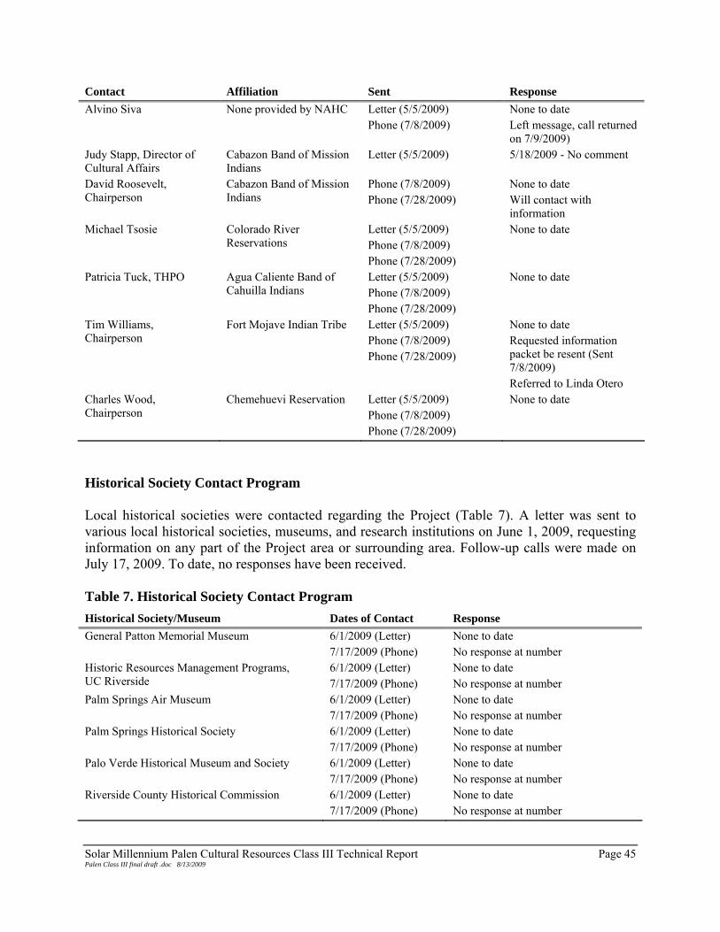
Solar Millennium Palen Cultural Resources Class III Technical Report Page 45 Palen Class III final draft .doc 8/13/2009
Contact Affiliation Sent Response Alvino Siva None provided by NAHC Letter (5/5/2009)
Phone (7/8/2009) None to date Left message, call returned on 7/9/2009)
Judy Stapp, Director of Cultural Affairs
Cabazon Band of Mission Indians
Letter (5/5/2009) 5/18/2009 - No comment
David Roosevelt, Chairperson
Cabazon Band of Mission Indians
Phone (7/8/2009) Phone (7/28/2009)
None to date Will contact with information
Michael Tsosie Colorado River Reservations
Letter (5/5/2009) Phone (7/8/2009) Phone (7/28/2009)
None to date
Patricia Tuck, THPO Agua Caliente Band of Cahuilla Indians
Letter (5/5/2009) Phone (7/8/2009) Phone (7/28/2009)
None to date
Tim Williams, Chairperson
Fort Mojave Indian Tribe Letter (5/5/2009) Phone (7/8/2009) Phone (7/28/2009)
None to date Requested information packet be resent (Sent 7/8/2009) Referred to Linda Otero
Charles Wood, Chairperson
Chemehuevi Reservation Letter (5/5/2009) Phone (7/8/2009) Phone (7/28/2009)
None to date
Historical Society Contact Program Local historical societies were contacted regarding the Project (Table 7). A letter was sent to various local historical societies, museums, and research institutions on June 1, 2009, requesting information on any part of the Project area or surrounding area. Follow-up calls were made on July 17, 2009. To date, no responses have been received. Table 7. Historical Society Contact Program Historical Society/Museum Dates of Contact Response General Patton Memorial Museum 6/1/2009 (Letter)
7/17/2009 (Phone) None to date No response at number
Historic Resources Management Programs, UC Riverside
6/1/2009 (Letter) 7/17/2009 (Phone)
None to date No response at number
Palm Springs Air Museum 6/1/2009 (Letter) 7/17/2009 (Phone)
None to date No response at number
Palm Springs Historical Society 6/1/2009 (Letter) 7/17/2009 (Phone)
None to date No response at number
Palo Verde Historical Museum and Society 6/1/2009 (Letter) 7/17/2009 (Phone)
None to date No response at number
Riverside County Historical Commission 6/1/2009 (Letter) 7/17/2009 (Phone)
None to date No response at number
Solar Millennium Palen Cultural Resources Class III Technical Report Page 46 Palen Class III final draft .doc 8/13/2009
Agency Contacts Several agencies were contacted for consultation on the PSPP. Relevant agency contacts are provides in Table 8. Table 8. Agency Contacts for the PSPP Agency Contact Phone/E-mail Permit/Issue Native American Heritage Commission David Singleton
(916) 653-6251 [email protected]
Native American cultural issues
Bureau of Land Management, Palm Springs Field Office Chris Dalu
(760) 833-7105 [email protected]
BLM Fieldwork Authorization and coordination of fieldwork on behalf of the BLM
California Energy Commission Mike McGuirt
[email protected] CEC coordination of project activities
Permits Required The PSPP is located on BLM land. Prior to all archaeological field investigations on BLM land, a Fieldwork Authorization Request must be filed and approved by the BLM. EDAW filed a Fieldwork Authorization Request under statewide BLM permit (CA-06-21). The request indicated areas to be surveyed, supervisory personnel, and survey dates. Maps of the survey areas accompanied the request. A Fieldwork Authorization was obtained on March 10, 2009 for cultural resources studies of the PSPP.

Solar Millennium Palen Cultural Resources Class III Technical Report Page 47 Palen Class III final draft .doc 8/13/2009
CHAPTER 4 – METHODS
SURVEY METHODOLOGY EDAW conducted a Class III archaeological survey of the Project footprint and a 200-ft buffer per CEC requirements. The survey corridor for linear components included the ROW and 50 ft on both sides of the alignment. A historical architecture field survey of the built environment with a buffer of 0.5-miles was also completed by EDAW. The methods and results of that survey are included in Attachment 6 of this report. The Class III survey was conducted by four- to eight-person survey teams, each led by a crew chief. A maximum survey interval of 20 m was employed. The survey teams were supplemented by follow-up site recordation teams. When archaeological sites were encountered, the survey team determined the location of the site using handheld global positioning system (GPS) units and flagged the location for subsequent recordation by a recording team(s). An arbitrary distance of 50 m between artifacts and features was used to divide cultural material into individual sites. For the purposes of the Project, three or fewer artifacts within 30 m of one another were recorded as isolated finds and four or more artifacts within the same distance was recorded as an archaeological site. When survey teams identified cultural resources, transects were halted and the crew inspected the area for additional cultural resources in the general area. Once the site had been delineated based on surface conditions, a temporary recording form was completed. The form was designed to convey information from the survey team to the recordation team and included Universal Transverse Mercator (UTM) coordinates, site type, approximate site size, number and types of artifacts, and impacts noted at the site. There was also space for notations about specific site features or artifacts types to aid the recordation teams in finding and recording the site. Site recordation included photographic documentation (site overviews and detail shots including diagnostic artifacts), site sketch maps (recorded with submeter GPS units), artifact and feature descriptions, and environmental context. When recording a site, each team would re-survey the area at close an interval (typically 3 m or less) and identify all cultural material observed on the surface. Recordation teams also flagged unique or diagnostic artifacts to ensure they were photographed and recorded with the submeter GPS. Once a site was recorded, all flagging was removed from the site. There are no previously reported site locations within the PSPP survey area and a non-collective strategy was employed. The pedestrian archaeological survey of the entire Project site was conducted by EDAW between April 13 and May 6, 2009. The survey was conducted to identify possible cultural resources that

Solar Millennium Palen Cultural Resources Class III Technical Report Page 48 Palen Class III final draft .doc 8/13/2009
may be affected by the Project. The survey utilized both 7.5-minute USGS topographic maps and larger scale aerial maps. Documentation Sites identified during the survey were documented on appropriate DPR 523 forms. These included Primary forms (Form 523A) and USGS Location Map (Form 523J) at a minimum. More complex resources potentially required an Archaeological Site Record (Form 523C), Linear Feature Form (Form 523E), and/or a Sketch Map (Form 523K). Sketch maps included a site datum, features, artifacts concentrations, and other cultural elements. Isolated finds were noted and their location mapped. All isolates were recorded on a Primary form and USGS Location Map. Resource locations were determined using a GPS. Artifacts clustered in areas of the site were recorded as Concentrations. Parts of sites that could not be removed (i.e. hearths or mining claims) were recorded as Features. All completed DPR site forms will be sent to the EIC for the assignment of Primary number designations in the state inventory system. DPR forms are included in this report in Attachment 5. In addition to information for site forms, detailed field notes were produced for each site. Field notes contained information about site impacts, geology, vegetation, and diagnostic information about cultural materials at each site. SITE TYPES The Class III survey was designed to identify and evaluate archaeological sites to the extent possible from observed surface conditions. Prior to field investigations, it was important to consider first the types of cultural resources that were likely to be encountered and second the relevance of such resources for the investigation of regional research issues. Sites types common to the Colorado Desert and the PSPP were compiled in the Class III Work Plan (Apple and Cleland 2009) and are listed below. Prehistoric Trails Trails are generally tamped into stable surfaces, sometimes with larger gravel and pebbles pushed to the sides to form slight berms along the edges of the trail. In the desert, trails are typically found on shoulders and along tops of ridge systems, relatively stable alluvial fans, and other upland areas, often disappearing into a wash. Prehistoric trails can follow washes for considerable distances. Two trails, CA-RIV-53T (the Cocomaricopa Trail) and the CA-RIV-893T) are located near the PSPP (Eckhardt and Way 2004, Underwood et al. 2001) Lithic Scatters and Flaking Stations This resource category can range from single flaking stations to large scatters that often contain numerous flaking stations with a light background scatter of debitage. The flaking stations often include cores, but rarely tools. The tools that are found are usually blanks from early in the

Solar Millennium Palen Cultural Resources Class III Technical Report Page 49 Palen Class III final draft .doc 8/13/2009
manufacturing process, or expedient tools. The debitage in the lithic scatters is typically a result of core reduction activities. Debitage size is usually associated with the size of the parent material and is variable. A lithic study in nearby McCoy Wash attempted to look at reduction techniques and core size to provide a means of relative dating (Spencer et al. 2001). Although lithic scatters are generally interpreted by archaeologists as places where toolstone acquisition and tool manufacture occurred, Native American representatives have pointed out that certain ritual activities also result in the production of scatters of flaked stone materials (e.g., Cachora 1994). Ceramic Scatters and Pot Drops “Ceramic scatter” refers to a dispersed surface distribution of ceramics, typically from multiple vessels. A “pot drop” usually refers to a small, distinct concentration of sherds from a single vessel. As early as the 1930s, Malcolm Rogers recognized that trail shrines and other ceremonially significant sites in the Colorado Desert might contain concentrations of prehistoric ceramics. Cleared Circles Cleared circles, sometimes referred to as “sleeping circles,” are commonly found throughout the regional study area. These are cleared areas in the desert pavement that are roughly to nearly circular in outline. Cleared circles of sufficient size have often been considered to be “sleeping” or resting places, and smaller ones as vision quest or meditation circles (Davis 1980; Ezzo and Altschul 1993; Pigniolo et al. 1997; Rogers 1966; von Werlhof and von Werlhof 1977). Habitation debris is rarely found in direct association with cleared circles (Rogers 1966), and subsurface deposits at cleared circles in the Colorado Desert generally are very rare or absent (Marmaduke and Dosh 1994; Pendleton et al. 1986; Schaefer 1986). Rock Rings Prehistoric rock rings are commonly found throughout southeastern California, southwestern Arizona and Utah, southern Nevada, and the Pinacate region of Mexico. Rock rings are found as isolates or in clusters and are situated in areas of desert pavement or other stable surfaces. Rings larger than 1 m in diameter are generally regarded as habitation places, with the rocks possibly used to support brush “walls” (Pigniolo et al. 1997; von Werlhof and von Werlhof 1977). Smaller rock rings may indicate hearths or may have a ceremonial function (Cleland 2005; Pigniolo et al. 1997). Although generally circular in shape, these features also occur as ovoids or rectangles (Rogers 1966) and are composed of one (usually) or more courses of rocks ranging from cobble-sized to small boulders. Prehistoric Cairns Within the Colorado Desert, prehistoric cairns are typically situated on stable surfaces. The cairns, which may be partially collapsed, are generally composed of multiple courses of rocks consisting of pebbles to small boulders. Prehistoric cairns are frequently found associated with trails or other features.

Solar Millennium Palen Cultural Resources Class III Technical Report Page 50 Palen Class III final draft .doc 8/13/2009
Habitation Sites Habitation sites typically show evidence of a variety of occupation debris, including multiple artifact classes, subsistence wastes, FAR, and/or domestic architecture. This can include living areas (see also rock rings and cleared circles above); cooking hearths; subsistence remains (fish or mammal bone); middens; artifact scatters; and often discrete activity areas, such as lithic reduction, milling, or other subsistence-related activities. Petroglyphs Petroglyphs are formed by removing by various means the desert varnish or weathered surface from boulders or bedrock outcrops. Considered ceremonial in nature, petroglyphs in the Colorado Desert include anthropomorphic, zoomorphic, abstract, and geometric forms (Cleland and Apple 2003; Ezzo and Altshul 1993). Although found singly, petroglyphs usually occur clustered on rock faces, forming “panels.” Ground Figures – Geoglyphs and Rock Alignments For the purposes of this study, two types of ground figures are recognized: geoglyphs and rock alignments. Both are considered to have ceremonial or ritual significance. Geoglyphs, sometimes referred to as intaglios, are typically composed of figures incised or scraped into the desert pavement (Harner 1953; Johnson 1985; Rogers 1945). In this kind of geoglyph, the rocks and gravel forming the desert pavement are removed, exposing the lighter-colored soil to form the shape. The removed gravel is often pushed to the edge to form a low gravel berm around the geoglyph. Depending on the construction method and the degree of erosion, these berms can range from well defined to ill defined or nonexistent (von Werlhof 1987). Geoglyphs may alternatively be tamped into the desert pavement rather than incised. For example, in tamped rings, the pavement surface is compressed but not actually removed; these are thought to have been used in ritual circle dances (Johnson 1985; Solari and Johnson 1982; von Werlhof 2004). Ground figures can also be formed by an additive process wherein cobbles and/or small boulders are placed on the ground surface in various types of alignments (Johnson 1985; von Werlhof 1987). Such types are referred to herein as “rock alignments.” Cremations/Human Remains Human remains are highly sensitive culturally and are subject to special protection under federal and state law. Although relatively rare in the area, sites with cremations or other human remains have been recorded in the Colorado Desert. Groundstone Quarries and Groundstone Tools Evidence of groundstone production has been found in the Palo Verde Hills (Apple et al. 2001), Palo Verde Point (Johnson 2001), and Picacho Basin (Pendleton et al. 1986). Johnson (2001) indicates that there are several large quarries in the Palo Verde Point area utilized for the manufacture of mano, metate, and pestle blanks. At temporary campsites and habitation sites, groundstone tools are often cached or left in situ in places to which mobile groups intend to return. Historic

Solar Millennium Palen Cultural Resources Class III Technical Report Page 51 Palen Class III final draft .doc 8/13/2009
Transportation Routes Transportation routes consist of historic trails and roads. The condition of the roads may vary from faint two-tracks to graded or paved alignments, where the route not the road is significant. Roads in the PSPP may relate to early transportation through the Chuckwalla Valley. Other transportation routes in the area may be associated with DTC activities, such as two-track roads or tank tracks still visible on some surfaces. Historic Camps Evidence of temporary historic camps is found throughout the Colorado Desert. The camps may include cleared areas that are possibly historic tent pads and associated features such as campfire/hearths and debris scatters are often present. Types of camps include construction camps for linear facilities (railroads, transmission lines, water conveyance, etc.) and military or mining camps. Refuse Scatters and Dumps This feature type ranges from small discrete deposits to large sparse scatters. Often these are found along trails or roads, making associations difficult to establish. The Project is located in the DTC, which was an active military training facility during WWII. Refuse scatters dating between the mid-1930s to the late 1940s are likely representative of DTC activities. Earlier refuse deposits may date to historic routes through the area, including Highway 60/70 (presently Chuckwalla Valley Road). Historic Cairns Many of the rock piles within the Colorado Desert are associated with historic mining claims. These can vary in size and composition. Rarely a can or other container in the cairn will contain information regarding the claim. Isolated Finds Isolated finds consist of single, occasionally multiple, prehistoric or historic artifacts. Isolates have been found on a variety of surfaces, including desert pavement, gravel beds, and washes. RESEARCH ISSUES AND THEMES Research issues in the Colorado Desert region include questions that relate to both prehistoric and historic archaeological sites. Research issues can be categorized into research themes designed to answer questions about the past. Questions relevant to the region can be addressed by identification and analysis of cultural resources. Site types listed above can be assigned to various themes that may be used to answer questions about the use and development of the PSPP over time. Prehistoric Research Themes

Solar Millennium Palen Cultural Resources Class III Technical Report Page 52 Palen Class III final draft .doc 8/13/2009
Chronology Chronology building continues to be a major research emphasis in the Colorado Desert. Most of the known sites are surface sites consisting of lithic artifacts and ceramics. Stratified sites of any kind are very rare in the region as a whole (Cleland and Apple 2003; Schaefer 1994b{tc "Schaefer 1994 " \f D }{tc "Cleland and Apple 2003 " \f D }). The general concentration of populations within the lower river valleys has meant that the majority of sites with intact, datable deposits have been removed from the archaeological record by fluvial action. Thus, various factors have conspired to hinder the development of an adequate culture chronology in the region. In view of this, one of the most important aspects of a prehistoric research program for the Colorado Desert should be to aid in the refinement of the regional chronological framework. Any site that contains organic cultural remains suitable for radiocarbon dating could prove useful in this endeavor. Beyond this general observation, key chronometric topics that might be addressed include (1) the reliability of regional dating methods, (2) issues regarding the earliest phases of human occupation of the region, (3) problems related to the Archaic period occupation, and (4) refinements of the regional ceramic sequence. Additional areas of research include lithic technology, site formation processes, and trade and travel. Site types that may be associated with this theme include lithic scatters with temporally diagnostic projectile points, ceramic scatters and pot drops, and habitation sites. Prehistoric Settlement The PSPP is located in an area that has been categorized as containing highly mobile populations into the Late Prehistoric period (Singer 1984). Archaeological research in the Colorado Desert has not fully answered questions regarding early occupation and adaptations to unstable lacustrine environments (Schaefer 1994b). Archaeological sites along prehistoric shorelines in Mojave Desert to the north show evidence of a wide resource procurement strategy that included both small and large game, indicating that a range of habitats was utilized (Sutton et al. 2007:237). Studies of lacustrine environments in the Colorado Desert have mostly focused on Lake Cahuilla in the Coachella Valley beginning with Rogers (1945). Wilke’s (1978) archaeological excavations helped to confirm that the late Holocene saw a sequence of inundations at Lake Cahuilla. Working primarily around the northern end of the lake, Wilke focused largely on settlement and subsistence issues. He concluded that lake-stands were of sufficient duration and that the lacustrine environment was sufficiently productive to support year-round habitation of residential sites. However, evidence by Weide (1974) indicated that Lake Cahuilla filled and receded rapidly. As such, the viability of permanent shoreline settlements was called into question. Weide suggested that inland spring-fed streams provided more reliable and stable resources than shorelines could. Augmenting the argument, Weide and Barker (1974:106-107) suggested that the wide fluctuations of Lake Cahuilla would proved to be too unstable to support permanent habitation or large population shifts. Rather, small, seasonal camps were the only habitation sites possible along prehistoric shorelines.

Solar Millennium Palen Cultural Resources Class III Technical Report Page 53 Palen Class III final draft .doc 8/13/2009
This debate has fueled research across the Colorado Desert in subsequent years. Research orientations surrounding lacustrine environments are primarily focused on establishing sustainable population sizes within sites. This proves a challenging task because of the considerable variables involved, including site size, midden thickness/depth, artifact density, artifact variability, presence of multiple cremations or cremation grounds, presence of ceremonial artifacts, and other signs of sustained presence at a residential base for hunter-gatherer societies (Schaefer 1994b:69). Other aspects of lacustrine environments in the Colorado Desert are particularly relevant to the PSPP. Namely, areas where alluvial fans come abruptly down on to shorelines are likely to have more densely concentrated site clusters. Though research has indicated that shallow midden deposits exist at these sites (Schafer 1994b:70). The alluvial fan descending from the Chuckwalla Mountains towards the Palen playa may fit this physiologic characterization. Sub-surface midden or charcoal associated with hearth features or temporary campsites may contribute new information to the chronology of the Colorado Desert. Sites in the PSPP that may relate to this theme include lithic scatters and flaking stations, ceramic scatters and pot drops, habitation sites, cleared circles, rock rings, cremations and human remains, and groundstone tools. Lithic Technology The ways that hunter-gatherers chose to organize the procurement, manufacture, and discard of flaked stone tools varies in relationship to several factors, including the relative availability and quality of toolstone within their territorial range, intended tool functions, the frequency and nature of residential moves, organization of work groups, and division of labor (e.g., Bamforth 1990; Beck et al. 2002; Eerkens et al. 2007; Kelly 1988). Hence, the recording of lithic technology can be useful in addressing more general questions regarding territoriality, mobility, settlement patterns, and down-the-line exchange. For example, highly mobile peoples may “gear up” when they encounter knappable toolstone (Kelly and Todd 1988). In doing so, they discard curated tools, often from distant sources. Changes in toolstone procurement behavior may be reflective of intensified subsistence procurement within more restricted territories and/or changes in the scheduling and directionality of seasonal subsistence-related residential mobility. Because of high transport costs, groundstone tools are often cached or left in situ in places to which mobile groups intend to return. Though, high costs of groundstone transport may have been reduced by river transport (Schneider 2006). Because of this cost, these tool types may be good indications of a location of relatively frequent and/or long-term use. Groundstone procurement patterns have been studied along the lower Colorado River (Huckell 1986, Schneider 2006). The Bullhead City quarry, approximately 100 miles north of the PSPP on the Colorado River, produced a material variously referred to as alkali-olivine basalt or andesite used in the manufacture of metates (Schneider 2006). Huckell (1986) and Schneider (2006) both document Bullhead City (aka Big Bend) quarry. Huckell notes that the quarry appears to have been utilized by the Mohave for a period of a few hundred years (1986:55). Huckell further argues that the specialized nature and geographic range of metates is indicative of production and exchange of groundstone tools rather than simple procurement for personal use (1986:56).

Solar Millennium Palen Cultural Resources Class III Technical Report Page 54 Palen Class III final draft .doc 8/13/2009
Site types that may relate to this theme include lithic scatters, flaking stations, and groundstone tools. Historic Research Themes Previous cultural surveys indicate that historic period resources are present in lower frequency than prehistoric resources. Not surprisingly, as a result previous research efforts have similarly focused on prehistory, leaving historic period research questions relatively underdeveloped. From the inventory work that has been accomplished in the region, it appears that the following themes are most relevant to the PSPP: transportation, mining, agriculture/ranching, and military training activities. Today, the main route through the Chuckwalla Valley is I-10. According to historic topographic maps, Chuckwalla Valley Road (Highway 60/70) was the main road through the valley. In addition to established roads, numerous unpaved routes are present throughout the Colorado Desert. Two-track roads, unimproved roads, and graded dirt roads often are the remnants of early wagon or automobile routes. Material culture associated with early routes is evident on the landscape as well. Historic debris from early travel across the desert is evident in the form of cans or other refuse associated with vehicle maintenance. Oftentimes, debris associated with early automobile use is found adjacent to modern roadways, which may indicate the age and historic use of the route through time. Though large-scale mining was not a major endeavor in the Chuckwalla Valley or surrounding mountains, evidence of mining activities is still evident on the landscape. Remnants of prospect mining for various raw materials and claim posts with historic cans or jars may indicate that prospecting has taken place. Likewise, historic cairns may also indicate mining activities. Other signs include prospect pits, tailings, and debris located near a cairn or claim post. Historic references indicate that mining took place in the region well into the 20th century. Identifying mining activities, no matter the scale, informs the past development of the Project area and the region as a whole. California’s agricultural economy boomed with the advent of the Gold Rush, and further developed in the late 19th century with the passage of the Homestead Act in 1862 and the Desert Land Act of 1877. Passage of these acts allowed agriculture to develop in the Palo Verde Valley to the east. Agricultural development did not develop near the Project area, despite numerous Desert Land Entries filed in the PSPP. As agriculture and farming required larger tracts of land in order to achieve success, homesteading became marginalized over time. Though agriculture and ranching never became major industries near the PSPP before later in the 20th century (see Chapter 2), evidence of early attempts at agriculture and ranching may still be evident on the surface.

Solar Millennium Palen Cultural Resources Class III Technical Report Page 55 Palen Class III final draft .doc 8/13/2009
Lastly, one of the most significant research issues surrounds the area’s use as a military training facility. The history of the DTC has been well documented (see Bischoff 2000; Henley 1992; Meller 1946) though the material culture of the base is not well defined in all areas. The DTC was the largest military training facility ever operated and physical evidence of its use is visible throughout the region. Various activities may be identified due to the material remains of the DTC. One of the starkest pieces of evidence of DTC activities are tank tracks that have survived for decades. Just as prehistoric trails feature tamped surfaces from use over time, tank tracks leave a semi-permanent mark on the land. WWII-related military activity was not the only military presence in the PSPP in the past. Subsequent to Patton and the DTC, Operation Desert Strike (discussed in Chapter 2 above) encompassed portions of the current PSPP. Based on maps of the maneuver area, the PSPP was not a part of the active exercise. A water source was located near the PSPP, though it was not located in the Project area (Desert Strike n.d.). Debris from military activities is also evident on the surface. While tin cans tend to have wide dates of manufacture, other aspects, such as opening method, can date to very specific points in time. Tin cans are often overlooked in terms of their potential to yield information about a site, especially when artifacts like bottles are more easily dated. This can lead to archaeologists ignoring or not giving proper attention to their details (Busch 1981:102). However, proper identification and documentation of cans as one of several lines of evidence has the potential to narrow the range of historic archaeological sites.

Solar Millennium Palen Cultural Resources Class III Technical Report Page 56 Palen Class III final draft .doc 8/13/2009

Solar Millennium Palen Cultural Resources Class III Technical Report Page 57 Palen Class III final draft .doc 8/13/2009
CHAPTER 5 – ARCHAEOLOGICAL RESULTS
Project archaeologists performed pedestrian surveys of the Project between April 13 and May 6, 2009. The ground visibility was good, ranging between 95 and 100 percent. During the course of the survey, archaeologists identified 380 cultural resources. Fifty are archaeological sites and 330 are isolated finds. All archaeological sites were previously undocumented. The archaeological survey area, along with site and isolate locations are provided on 7.5-minute USGS topographical maps in Attachment 4. A summary of the identified resources are provided in Table 9 and site forms are included in Attachment 5. Of the 50 archaeological sites that were encountered, four are no longer within the Project APE (SMP-P-1019a, SMP-P-1019b, SMP-H-1027, SMP-P-2013a, and RMA-1). In addition, five archaeological sites are in the 200-ft buffer (SMP-P-1018, SMP-P-2008, SMP-P-2013b, and SMP-P-2018). Since these resources will not be impacted by the Project, no assessments were made. Table 9. Archaeological Sites Identified in the PSPP Temporary Number
Site Type/ Historic Context Theme(s) In APE In Buffer
Out of Project
SMP-H-1001 Historic Debris Scatter Military Y – – SMP-H-1002 Historic Debris Scatter Military Y – – SMP-H-1003 Historic Debris Scatter Military Y – – SMP-H-1004 Historic Debris Scatter Military Y – – SMP-H-1005 Historic Debris Scatter Military Y – – SMP-H-1006 Historic Debris Scatter Military Y – – SMP-H-1007 Historic Debris Scatter Military Y – – SMP-H-1008 Historic Debris Scatter Military Y – – SMP-H-1009 Historic Debris Scatter Military Y – – SMP-H-1010 Historic Debris Scatter Military Y – – SMP-H-1011 Historic Debris Scatter Military Y – – SMP-H-1012 Historic Debris Scatter Military Y – – SMP-H-1013 Historic Debris Scatter Military Y – – SMP-P-1015 Lithic Scatter Lithic Technology Y – – SMP-P-1016 Lithic Scatter Lithic Technology Y – – SMP-P-1017 Hearth Feature Prehistoric Settlement,
Lithic Technology Y – –
SMP-P-1018 Hearth Feature Prehistoric Settlement, Lithic Technology
– Y –
SMP-P-1019A Hearth Feature Prehistoric Settlement – – Y SMP-P-1019B Hearth Feature Prehistoric Settlement – – Y SMP-H-1020 Historic Debris Scatter Military Y – Y SMP-H-1021 Historic Debris Scatter Military Y – –

Solar Millennium Palen Cultural Resources Class III Technical Report Page 58 Palen Class III final draft .doc 8/13/2009
Temporary Number
Site Type/ Historic Context Theme(s) In APE In Buffer
Out of Project
SMP-H-1022 Historic Debris Scatter Military Y – – SMP-H-1023 Historic Debris Scatter Military Y – – SMP-H-1024 Power Line and Access
Road Regional Development Y – –
SMP-H-1025 Survey Markers Regional Development Y – – SMP-H-1026 Tank Tracks Military Y – – SMP-H-1027 Historic Road Transportation – Y SMP-H-1032 Historic Road Transportation Y – – SMP-H-2002 Historic Debris Scatter Military Y – – SMP-H-2003 Historic Debris Scatter Military Y – – SMP-H-2004 Historic Debris Scatter Military Y – – SMP-H-2006 Historic Debris Scatter Military Y – – SMP-H-2007 Historic Debris Scatter Military Y – – SMP-H-2008 Historic Debris Scatter Military – Y – SMP-H-2009 Tank Tracks Military Y – – SMP-H-2010 Historic Debris Scatter Military, Regional
Development Y – –
SMP-H-2011/2012
Historic Debris Scatter with military components
Military Y – –
SMP-P-2013A Temporary Camp Prehistoric Settlement – – Y SMP-P-2013B Lithic Scatter Lithic Technology – Y – SMP-P-2014 Lithic Scatter Lithic Technology Y – – SMP-P-2015 Lithic Scatter Lithic Technology Y – – SMP-H-2016 Historic Corral Agriculture/Ranching Y – – SMP-H-2017 Historic Debris Scatter Military Y – – SMP-P-2018 Lithic Scatter Lithic Technology – Y – SMP-H-2019 Historic Debris Scatter Military Y – – SMP-H-2020 Tank Tracks Military Y – – SMP-H-2021 Historic Debris Scatter Military Y – – SMP-H-2022 Historic Debris Scatter Military Y – – SMP-P-2023 Temporary Camp Prehistoric Settlement,
Lithic Technology Y – –
SMP-H-RMA-1 Historic Encampment Military – Y –
Site Descriptions and Significance Assessments SMP-H-1001 Site SMP-H-1001 is a historic debris scatter trending northeast-southwest and consisting of cans, glass fragments, and automobile parts located in an active alluvial wash. The site is situated between an improved graded dirt road and power line and I-10. All artifacts appear to be located on the surface without a subsurface component; though there is considerable redeposition of artifacts from sheet wash originating from one of several dikes located at the base of an alluvial fan descending from the Chuckwalla Mountains to the south.

Solar Millennium Palen Cultural Resources Class III Technical Report Page 59 Palen Class III final draft .doc 8/13/2009
The overall dimensions of the site are 110 m (360 ft) north-south by 43 m (140 ft) east-west. The site is located on an alluvial fan descending from the Chuckwalla Mountains to the south. The site sits in an active wash comprised of tan to grey sandy silts. The wash cuts through desert pavement with little to no patinated surfaces. Poorly sorted sub-angular to angular pebbles and small cobbles are present throughout the site. Vegetation on the site includes creosote, desert scrub plants, and sparse ironwood trees. There is one concentration (Concentration 1) of artifacts at the site consisting of tin cans and car parts. Concentration 1 measures 1.5 m (5 ft) north-south by 3.5 m (12 ft) east-west and includes punched evaporated milk cans, punched beverage cans, church-key opened beverage cans, can lids (5 measuring 3 in and 1 measuring 2 in), two key strip opened meat tins, and car parts (consisting of portions of the engine block and gasket). Outlying artifacts around Concentration 1 consist of beverage cans (including punched and church-key opened cans), evaporated milk cans, kerosene cans, key-wind meat tins, a clear glass bottle, and can fragments. The glass bottle has an Owens-Illinois Duraglas maker’s mark on the base. According to Toulouse (1971), Duraglas bottles were used by the Owen’s Illinois Company since 1940. Cans at the site likely date to the 1930s to 1950s based on mixed use of punched cans and church-key opened beverage cans (Rock 1987). Impacts to the site include alluvial and aeolian disturbance associated with the dike and wash to the south. These forces have compromised the site’s integrity. Other impacts are related to the site’s location near I-10 and dumping of modern debris. Based on artifacts identified at SMP-H-1001, it is possible that it is related to Patton’s DTC activities in the early 1940s. It is also possible that this site is related to early roadways through the Chuckwalla Valley, including Highway 60/70 (presently Chuckwalla Valley Road). Beverage cans identified at the site date to between 1935 and the 1950s. In addition, the presence of double-seamed sanitary cans date to between 1908 and the 1940s (Rock 1987). The glass bottle dates to between 1940 and 1954 (Toulouse 1971:403). SMP-H-1001 is recommended not eligible for inclusion to the CRHR and NRHP. The site is not associated with events that have contributed to the broad patterns of cultural history (CRHR Criterion 1/NRHP Criterion A). Nor is the site associated with the lives of persons important to California’s past (CRHR Criterion 2/NRHP Criterion B). The site does not embody a distinct style, type, period, or region (CRHR Criterion 3/NRHP Criterion C) and the site is not likely to yield information that is important to prehistory or history (CRHR Criterion 4/NRHP Criterion D). SMP-H-1002 This site is a historic debris scatter comprised of approximately 25 widely dispersed tin cans and one glass bottle fragment intermixed with modern debris. The site is located between a power line and graded dirt road (Site SMP-H-1024) and I-10. All artifacts appear to be located on the surface without a subsurface component; though there is considerable redeposition of artifacts due to sheet wash originating from one of several dikes located at the base of an alluvial fan

Solar Millennium Palen Cultural Resources Class III Technical Report Page 60 Palen Class III final draft .doc 8/13/2009
descending from the Chuckwalla Mountains to the south (Plate 6). The predominant vegetation on this site is creosote bush scrub with some sparse ironwood trees.
Plate 6. SMP-H-1002 facing north The site measures 50 m (170 ft) north-south by 100 m (325 ft) east-west and is located in an alluvial wash on an alluvial fan descending from the Chuckwalla Mountains. Sediments in the wash include sandy silts. Adjacent surfaces contain desert pavement with little to no patination. The desert pavement consists of poorly sorted subangular to angular pebbles and cobbles. Vegetation on the site includes creosote and desert scrub communities. Artifacts at the site include church-key opened beverage cans, food canisters measuring between 4¼ in in diameter and 5 to 5½ in tall, cone-top cans, and a clear glass Coca-Cola 6 ounce (oz.) bottle fragment from the San Bernardino Bottling Plant. Church-key-opened beverage containers and cone-top beer cans were mostly in use between 1935 and the 1950s (Rock 1987). Six-ounce glass Coca-Cola bottles were used between 1915 and the 1950s. It is possible that SMP-H-1002 dates to Patton’s DTC activities of the 1940s, early transportation along Highway 60/70 (presently Chuckwalla Valley Road), or to construction and maintenance of a nearby power line and associated access road. Impacts to the site include artifact redistribution due to sheet wash and aeolian actions. The wash in which the site is located originates from a dike located at the base of an alluvial fan descending from the Chuckwalla Mountains. It appears that artifacts at the site have been moved

Solar Millennium Palen Cultural Resources Class III Technical Report Page 61 Palen Class III final draft .doc 8/13/2009
since their original deposition. Additional impacts include modern debris that is intermixed with historic artifacts, from roadside dumping along I-10. Artifacts at the site date to multiple events associated with Project area and impacts to the site have compromised its integrity. SMP-H-1002 is recommended not eligible for inclusion in the CRHR or the NRHP. The site does not contribute to the broad patterns of history and is recommended not eligible under CRHR Criterion 1 and NRHP Criterion A. The site is not related to persons important to history and is recommended not eligible under CRHR Criterion 2 and NRHP Criterion B. The site does not represent a distinct or unique style, type, or design and is recommended not eligible under CRHR Criterion 3 and NRHP Criterion C. Site SMP-H-1002 is not likely to provide data important to history or prehistory and is recommended not eligible under CRHR Criterion 4 and NRHP Criterion D. SMP-H-1003 Site SMP-H-1003 sparsely scattered tin can deposit consisting of 11 tin cans and can fragments and one clear glass fragment. Modern debris is also intermixed with historic artifacts. The site is crossed by an unimproved two-track road (east-west) and an active ephemeral wash (north-south) is located along the site’s western edge. I-10 is also located to the south of the site and the Corn Springs exit on the interstate is located to the west of the site. All artifacts appear to be located on the surface and many of the artifacts appear to have been redeposited since original deposition. Vegetation is sparse on the site. Dominant vegetation species at SMP-H-1003 include creosote, desert scrub communities and sparse ironwood trees. Young, less cemented, lighter colored desert pavement characterizes the patches of more stable surfaces in this portion of the Project. Sediments on the site are tan to grey sandy silts located among the desert pavement as it deflates and transitions into an alluvial fan trending to the north from the Chuckwalla Mountains. Poorly sorted angular to subangular gravels and small and large cobbles are present. The site measures 80 m (270 ft) north-south by 50 m (170 ft) east-west and includes four oil cans, three key-strip opened cans, one water soluble coffee tin, three beverage cans, and one glass bottle fragment. Embossing is evident on several oil cans and includes a can embossed with “SAE 30” and “RICHFIELD OIL/ 20SAE/20 W/CORPORATION.” Oil cans began to be used in the 1930s with companies beginning to use cans exclusively in 1936 (Rock 1987:57). Oil cans and beverage cans at the site are church-key-opened, a method developed in 1935 (Rock 1987:112). The only glass identified at the site was a clear fragment of glass. Impacts to the site include displacement of artifacts since deposition. Other impacts to the site are associated with continued dumping of modern debris at and near the site. Based on the dates associated with artifacts located at SMP-H-1003, it is likely that the site represents a single refuse deposit dating to the 1930s or 1940s. It is possible that oil cans at the site are related to vehicle maintenance at Patton’s DTC operations in the area. Sinclair Oil Company was an oil manufacturer between the early 20th century and the 1960s and the

Solar Millennium Palen Cultural Resources Class III Technical Report Page 62 Palen Class III final draft .doc 8/13/2009
transition to tin oil cans occurred in the 1930s (Rock 1987). In addition, church-key-opened beverage cans at the site date to within the 1930s and 1940s timeframe. Site SMP-H-1003 is recommended not eligible for inclusion to the CRHR and NRHP. The site is does not directly relate to events important to the history of California (CRHR Criterion 1/NRHP Criterion A) and the site is not related to persons important to local, regional, or national history (CRHR Criterion 2/ NRHP Criterion B). The site does not contain elements that represent a distinct style, type, period, or region (CRHR Criterion 3/NRHP Criterion C). Due to impacts at the site, the site lacks integrity, is unlikely to yield information important to prehistory or history, and is recommended not eligible for inclusion to the CRHR under Criterion 4 or NRHP under Criterion D. SMP-H-1004 The site is a sparsely scattered historic debris scatter comprised of tin cans, porcelain ceramic fragments, and fragments of milled lumber. The site rests on an alluvial fan descending from the Chuckwalla Mountains. Several ephemeral drainages surround the site on the east and west, and cross the site near its southeastern boundary. None of the artifacts are clustered in an area and may have been redistributed since their initial deposition. An unnamed unimproved two-track road is located to the immediate east of the site, but does not cross the site. Vegetation on SMP-H-1004 is sparse and includes creosote, white bursage, and low-lying desert grasses. Invasive Saharan mustard is also a dominant species on the landscape. Sediments at the site include poorly sorted tan to grey sandy silt with angular to subangular gravels and small cobbles. The site measures 110 m (360 ft) north-south by 80 m (270 ft) east-west. Various can types are present at the site and include oil cans, vacuum packed tuna cans, church-key-opened and P38-opened beverage cans. Oil cans documented at SMP-H-1004 include one Esso oil can, one SAE 40 oil can, and seven Shell oil cans. A jadeite fragment is also present at the site. It appears to be a fragment from a mug or other small vessel and measures 3½ in tall by 2½ in wide. Milled lumber at the site is a modern intrusive deposit, consisting of wood lath measuring ⅝ in by 1½ in. Six pieces of wood lath of various lengths are located along the eastern and northwestern portions of the site. Impacts to the site include redeposition of artifacts located on the alluvial fan. Other impacts include dumping of modern refuse. It is possible that the artifacts at SMP-H-1004 are related to the DTC-activities during 1942 to 1944. The number of oil cans, many of which were punched open, and the number of beverage cans, many of which were church-key opened indicate that this site represents the remnants of a single event refuse deposit where large numbers of cans were discarded. Oil cans began to be widely used around 1936 (Rock 1987:57). Church-key can openers also became common in the 1930s (Rock 1987:112). Lastly, the presence of P38-opened cans indicates that the site is associated with military actions. The P38 was used widely during WWII as a means of opening C-rations (Moody 2008).
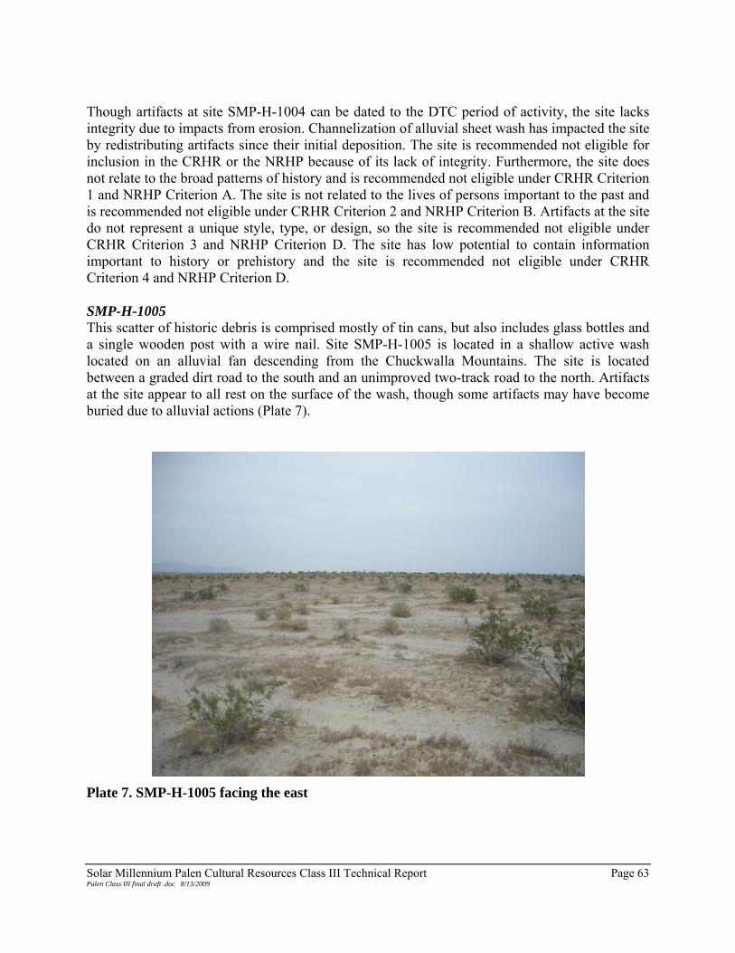
Solar Millennium Palen Cultural Resources Class III Technical Report Page 63 Palen Class III final draft .doc 8/13/2009
Though artifacts at site SMP-H-1004 can be dated to the DTC period of activity, the site lacks integrity due to impacts from erosion. Channelization of alluvial sheet wash has impacted the site by redistributing artifacts since their initial deposition. The site is recommended not eligible for inclusion in the CRHR or the NRHP because of its lack of integrity. Furthermore, the site does not relate to the broad patterns of history and is recommended not eligible under CRHR Criterion 1 and NRHP Criterion A. The site is not related to the lives of persons important to the past and is recommended not eligible under CRHR Criterion 2 and NRHP Criterion B. Artifacts at the site do not represent a unique style, type, or design, so the site is recommended not eligible under CRHR Criterion 3 and NRHP Criterion D. The site has low potential to contain information important to history or prehistory and the site is recommended not eligible under CRHR Criterion 4 and NRHP Criterion D. SMP-H-1005 This scatter of historic debris is comprised mostly of tin cans, but also includes glass bottles and a single wooden post with a wire nail. Site SMP-H-1005 is located in a shallow active wash located on an alluvial fan descending from the Chuckwalla Mountains. The site is located between a graded dirt road to the south and an unimproved two-track road to the north. Artifacts at the site appear to all rest on the surface of the wash, though some artifacts may have become buried due to alluvial actions (Plate 7).
Plate 7. SMP-H-1005 facing the east

Solar Millennium Palen Cultural Resources Class III Technical Report Page 64 Palen Class III final draft .doc 8/13/2009
Vegetation at the site includes creosote and desert scrub with ironwood trees, saltbrush, and cholla in the immediate vicinity. Vegetation is sparse within the site due to the active wash, The wash consists of poorly sorted tan to grey sands with angular to subangular pebbles. Sparse cobbles that have washed down the alluvial fan are also present within the wash. The wash in which the site is located is partially formed by a series of dikes located at the base of the Chuckwalla Mountains near Chuckwalla Valley Road. The site measures 455 m (1,490 ft) north-south by 125 m (415 ft) east-west and contains a total of 125 cans and three bottles. A single concentration of cans (Concentration 1) is located along the western edge of the site. Concentration 1 contains a total of 19 cans over a 39 m (127 ft) by 8 m (26 ft) area. The concentration includes eight key-strip-opened meat tins (one with the key still attached), seven church-key-opened or punched-open beverage cans, a juice can embossed with a Hines Apple Juice label, and a small unidentified can. The Heinz apple juice can was church-key opened and the unidentified can was P38 opened. Concentration 1 is in relatively good condition compared to the rest of the site because it rests on a high point in the wash where alluvial sheet wash appears to have had minimal impact. However, it is not clear if Concentration 1 represents a primary deposition or if it has been redistributed since its original deposition. Remaining artifacts at the site include 106 cans and three bottles widely dispersed throughout the wash. Cans at the site are primarily church-key opened beverage cans (48 total), seven oil cans, 31 key-strip-opened cans (four of which had intact lids attached), three water soluble coffee tins, and seventeen unidentified cans or can fragments. One of the beer cans had the remnants of a Coors label and several oil cans had legible embossing, including “SAE 50,” “SAE 30,” “Texaco” with a star emblem, and “Pennzoil SAE 30.” Three bottles at the site included a half pint amber glass bottle measuring 6¾ in tall with an Anchor Hocking maker’s mark. The bottle also contains the words “FEDERAL LAW FORBIDS SALE OR RE-USE OF THIS BOTTLE,” which was required on all liquor bottles beginning in 1935 (Busch 1987) A second half-pint amber glass bottle with the same measurements as the first was also located at the site, though its maker’s mark is an “F” in a hexagon. The last bottle located at the site is a clear glass bottle measuring 10¾ in tall with a 3¼-in base with an Owens-Illinois maker’s mark. The neck of this bottle also reads the same as the script on the two amber bottles. A wooden post is located on the eastern side of the site and contains a single wire nail. The post measures 3 in by 4 in by 55 in and is possibly the remnants of a mining claim. However, no information about the claim was located at the site and there is no evidence of mining in the immediate area. Artifacts at the site appear to date to the between the 1930s and 1940s, likely to the DTC period of use between 1942 and 1944. The presence of church-key-opened beer cans, P38-opened cans, and oil cans suggest that the site dates to the DTC. The Anchor Hocking glass bottle maker’s mark has been used since 1938 (Toulouse 1971:49). The “F” maker’s mark indicates the bottle was manufactured by Fairmount Glass works between 1945 and 1960 (Toulouse 1971:201). The Owens-Illinois maker’s mark consists of the “I” and “O” overlain by a diamond and dates to between 1929 and 1954 (Toulouse 1971:403).

Solar Millennium Palen Cultural Resources Class III Technical Report Page 65 Palen Class III final draft .doc 8/13/2009
It is unclear if the artifacts at SMP-H-1005 represent a single or multiple dumping episodes because the alluvial wash in which the site is located has severely compromised the site’s integrity. Artifacts have been redistributed due to alluvial and aeolian events. Artifacts that fall outside the years of operation of the DTC may date to roadside refuse or camping/picnicking travelers through the area, though this cannot be confirmed. Site SMP-H-1005 has poor integrity. The site does not contribute to the broad patterns of history and is recommended not eligible under CRHR Criterion 1 and NRHP Criterion A. The site is not related to persons important to history and is recommended not eligible under CRHR Criterion 2 and NRHP Criterion B. The site does not represent a distinct or unique style, type, or design and is recommended not eligible under CRHR Criterion 3 and NRHP Criterion C. Site SMP-H-1005 is not likely to provide data important to history or prehistory and is recommended not eligible under CRHR Criterion 4 and NRHP Criterion D. SMP-H-1006 Site SMP-H-1006 is a historic debris scatter that contains nine tin cans and a single glass jar sparsely scattered over an area 140 m (460 ft) north-south by 27 m (90 ft) east-west. The site is located in a wash with several ephemeral drainages impacting the site. The wash originates from a series of dikes located at the base of the Chuckwalla Mountains. An unimproved two-track dirt road is located to the north of the site. Vegetation at the site is dominated by creosote and desert scrub, including saltbush and low-lying grasses. Sediments at the site include poorly sorted tan to grey silty sand with angular to subangular pebbles. The wash in which the site is part of an alluvial fan and the site is located in a less active alluvial setting than other sites in the area (e.g. SMP-H-1005 above). Artifacts at SMP-H-1006 include two church-key-opened beverage cans, one knife-punched sanitary can, one church-key-opened evaporated milk can, one key-strip-opened can with no lid, one sanitary can fragment, and two indeterminate can fragments. The glass medicine bottle is located at the northern portion of the site and has “CHESEBROUGH/MFG/CO CD/ NEW YORK” on the base. The bottle measures 2 in on the base and is 2½ in tall. The artifacts at SMP-H-1006 appear to date to the DTC between 1942 and 1944. The use of church-keys to open beverage cans and punched sanitary cans suggest that these artifacts date to the late 1930s or early 1940s (Rock 1987). It is also possible that cans and glass at the site relate to travelers through the area before or shortly after the DTC was in use. Disturbances at the site are related to the alluvial actions. The number of artifacts suggests that the site represents a single event refuse deposit, but the site’s location within a wash suggests that it has been redistributed over time. Based on the poor integrity, lack of associations, and lack of data potential at site SMP-H-1006, the site is recommended not eligible for inclusion in the CRHR or the NRHP. The site does not contribute to the broad patterns of California’s history and is recommended not eligible under CRHR Criterion 1 and NRHP Criterion A. The site is not associated with persons important to California’s past and recommended not eligible for inclusion in the CRHR under Criterion 2 and

Solar Millennium Palen Cultural Resources Class III Technical Report Page 66 Palen Class III final draft .doc 8/13/2009
the NRHP under Criterion B. The site does not represent a distinct type, style, or design and recommended not eligible under CRHR Criterion 3 and NRHP Criterion C. Lastly, the site is unlikely to yield information important to history or prehistory and is recommended not eligible for inclusion in the CRHR under Criterion 4 and NRHP under Criterion D. SMP-H-1007 This widely dispersed historic debris scatter consisting of historic and modern debris appears to be the result of several depositional events. The site is located on an active alluvial wash that originates from a dike located south of the Project area at the base of the Chuckwalla Mountains. The dike has channelized alluvial sheet wash as it descends from the Chuckwalla Mountains towards Palen Dry Lake to the north. Erosion and channelization associated with the dike has redistributed artifacts after they were initially deposited. Vegetation at SMP-H-1007 includes creosote and desert scrub with low-lying grasses and ironwood trees. Vegetation is sparse within the site because of its location within the active alluvial wash. Sediments at the site include poorly sorted tan to grey sandy silts with angular to subangular pebbles. The site is part of an alluvial fan descending from the Chuckwalla Mountains and lies within a transition zone from an active wash to an alluvial fan. Dimensions of the site are 460 m (1,509 ft) north-south by 175 m (570 ft) east-west. The assemblage is composed of tin cans, glass fragments, automobile parts, and construction debris in the form of milled lumber. There is one concentration of artifacts (Concentration 1) and one feature (Feature 1). Concentration 1 is located near the center of the site and measures 10 m (33 ft) north-south by 5 m (16 ft) east-west. It includes a single hand saw, five church-key-opened beverage cans, two aluminum pull-ring cans, one pocket tobacco tin, one crushed can, and one unidentifiable can measuring 2 ⅛ in by 3 ⅞ in with illegible embossing. Artifacts in Concentration 1 are located on a high point in the wash that appears to be eroding away due to alluvial actions associated with the wash. Feature 1 is the remains of a mining claim and includes tin cans, the remains of a shovel, and two wooden posts embedded in the ground. One post has a cairn of rocks stacked at its base and measures 3½ in in diameter and is 38 in long. A piece of bailing wire is on the top of the post. The second post is located 8 ft to the southwest and measures ¼ in by 3½ in and measures 78 in tall. A metal fence post is lashed to the post with bailing wire. A clear jar is attached to the post with bailing wire. The jar is measures 4 in by 7½ in and has a maker’s mark that is a “T” with a smaller “M” and “C” under the bridge of the letter “T” The maker’s mark is unidentified, but a similar mark is associated with Thatcher Manufacturing Company between 1900 and at least 1971 (Toulouse 1971:496). Outlying artifacts scattered throughout the site are mostly tin cans (over 200), but glass fragments, milled lumber, and automobile parts are also present. The vast majority of cans at the site are church-key-opened beverage cans and ring-pull cans. Other cans at the site include various sizes of key-strip-opened cans, sanitary cans, oil cans, rotary-opened cans, P38-opened

Solar Millennium Palen Cultural Resources Class III Technical Report Page 67 Palen Class III final draft .doc 8/13/2009
cans, and meat tins. Glass at the site was fragmentary amber glass with no discernable maker’s mark. Milled lumber and construction debris at the site is the remnants of a wooden staircase and dispersed wood near the northern end of the site. Construction debris is intermixed with galvanized rubber, along with a 6 in metal pipe fragment. Automobile parts are located at the northern edge of the site and include a grill from a Ford vehicle and two circular air filters. Milled lumber fragments are also located near the automobile parts. It appears that artifacts at SMP-H-1007 date to between the 1940s and 1960s based on can types and opening methods observed. Church-key openers and P38 were widely used in the 1930s and 1940s (Moody 2008; Rock 1987:112) and pull rings began to be used on cans beginning in the early 1960s (Rock 1987:15). Glass at the site represents a long period of use and cannot provide a reliable date range. Based on surface conditions, it is possible that artifacts represent several depositional episodes, none of which can be reliably identified. Sheet wash has impacted the site. The site is located in the middle of a wash originating from a dike located south of Chuckwalla Valley Road at the base of the Chuckwalla Mountains. Other impacts are associated with debris from later years that has intermixed with historic artifacts within the wash. It is possible that much of the debris dates to as late as the 1970s (Rock 1987; Toulouse 1971). Site SMP-H-1007 is recommended not eligible for inclusion to the CRHR or the NRHP. The site does not relate to events important to history and is recommended not eligible for inclusion in the CRHR under Criterion 1 and the NRHP under Criterion A. The site is not associated with persons important to the past and is recommended not eligible for inclusion to the CRHR under Criterion 2 and NRHP under Criterion B. None of the artifacts at the site represent a unique style, type, or design and SMP-H-1007 is recommended not eligible under CRHR Criterion 3 and NRHP Criterion C. The site is unlikely to yield information important to history or prehistory and is recommended not eligible for inclusion in the CRHR under Criterion 4 and the NRHP under Criterion D. SMP-H-1008 Site SMP-H-1008 is a historic debris scatter consisting primarily of tin cans. Also present at the site are a glass jar fragment, milled lumber fragments, and a military issue spoon. Artifacts are widely dispersed. The site is located on an alluvial fan originating from the base of the Chuckwalla Mountains south of the Project area. All artifacts appear to be located on the surface of the site and appear to have been redistributed due to alluvial The site is located among sparse creosote and low-lying desert grasses. Several ironwood trees are also present. Sediments at the site include poorly sorted silty sand among angular to subangular pebbles and small cobbles. Artifacts are dispersed over an area with dimensions of 105 m (350 ft) north-south by 160 m (535 ft) east-west. Two ephemeral washes trending north-south cross the site. Flooding episodes appear to have clustered some artifacts. No features or concentrations were observed. The assemblage contains various tin cans, including sanitary, church-key opened beverage cans,

Solar Millennium Palen Cultural Resources Class III Technical Report Page 68 Palen Class III final draft .doc 8/13/2009
single friction, key-strip opened, flat round, hinge lid, and square meat tins. Also present are several pieces of milled lumber and metal spoon with “U.S.” stamped on the handle. Cans at the site likely date to the 1930s or later, possibly to the DTC between 1942 and 1944. The presence of sanitary cans and church-key-opened beverage cans would suggest this date range as sanitary cans were used less frequently in the 1930s and the church-key method of opening cans began in 1935 (Rock 1987). Additionally, the spoon stamped “U.S.” further indicates that the site dates to the DTC. Historic maps of the area do not show any structures at the site location. Milled lumber at the site may be associated with activities associated at the DTC or other automobile traffic through the area. No other evidence of structures is present at the site. Impacts to the site are mostly due to alluvial actions that have redistributed artifacts across the site, however, aeolian impacts may have redistributed artifacts as well. All artifacts appear to be located on the surface and a subsurface component does not seem apparent. Site SMP-H-1008 is recommended not eligible for inclusion in the CRHR or the NRHP under all Criteria. The site is does not contribute to the broad patterns of history and is recommended not eligible under CRHR Criterion 1 and NRHP Criterion A. The site is not related to individuals important to history and is recommended not eligible under CRHR Criterion 2 and NRHP Criterion B. The site does not represent a distinct style, type, or design and is recommended not eligible under CRHR Criterion 3 and NRHP Criterion C. The site has low potential to yield information that is important to history or prehistory and is recommended not eligible under CRHR Criterion 4 and NRHP Criterion D. SMP-H-1009 This widely dispersed historic debris scatter of modern and historic debris is scattered over a 165 m (540 ft) north-south by 85 m (280 ft) east-west area. Artifacts at the SMP-H-1009 include tin cans, pull-ring beverage cans, church-key-opened beverage cans, and one glass bottle. The site is located in an active wash on an alluvial fan extending north from the Chuckwalla Mountains. The wash originates from one of a series of dikes located at the base of the mountains. The vegetation includes sparse creosote, ironwoods, mesquite, and low bunch grasses. Sediments are fine- to medium-grain silty sand with poorly sorted angular to subangular gravels. Artifacts at the site are mostly beverage cans and include church-key-opened beverage cans and punched milk cans. Other cans at the site include key-strip-opened meat tins and oblong fish tins. An olive green glass bottle has an Obear-Nestor Glass Company maker’s mark dating to between 1915 and at least 1971 (Toulouse 1971). Impacts consist of erosion due to alluvial actions consistent with the southern portion of the PSPP. Other impacts are associated with modern refuse deposited at the site. Artifacts at SMP-H-1009 possibly date to the DTC, as church-key-opened cans and oblong fish tins date to the 1930s

Solar Millennium Palen Cultural Resources Class III Technical Report Page 69 Palen Class III final draft .doc 8/13/2009
and 1940s (Rock 1987:112). However, pull-tab beverage cans date to the late 1960s, suggesting that some artifacts from later dumping episodes are also present at the site (Rock 1987:15). Site SMP-H-1009 lack integrity based on sheet wash associated with the alluvial fan at the base of the Chuckwalla Mountains. Furthermore, artifacts at the site appear to date to a wide time period, with no identifiable dumping events evident because of alluvial impacts. Because of impacts, SMP-H-1009 is recommended not eligible for inclusion in the CRHR or the NRHP. The site does not contribute to the broad patterns of history and is recommend not eligible under CRHR Criterion 1 and NRHP Criterion A. The site is not associated with individuals important to history and is recommended not eligible under CRHR Criterion 2 and NRHP Criterion B. SMP-H-1009 does not represent a distinct style, type, or design and is recommended not eligible under CRHR Criterion 3 and NRHP Criterion C. Lastly, the site does not appear to contain information important to history or prehistory and is recommended not eligible under CRHR Criterion 4 and NRHP Criterion D. SMP-H-1010 Site SMP-H-1010 is a historic debris scatter consisting of 33 widely dispersed tin cans and a single medicine over a 80 m (265 ft) north-south by 150 m (490 ft) east-west area. In addition to the artifacts, a single set of tank tracks (Feature 1) trending southeast to northwest is present. The site is located on an alluvial fan descending from the Chuckwalla Mountains to the south. Vegetation at the site includes sparse creosote, desert scrub, and low-lying grasses. Sediments at the site consist of tan to grey silty sands with poorly sorted angular to subangular gravels and some small cobbles. The site is located on a portion of the alluvial fan that transitions from desert pavements to alluvium. Desert pavement at the site appears to less embedded and has no patination, suggesting that it is younger than pavements higher on the fan to the south. Tin cans at the site include various beverage cans such as punched three-piece cylindrical and church-key-opened beverage canisters, and key-opening nonreclosure cans (probably sardine or other fish tins). Feature 1 is a set of southeast-northwest-trending tank tracks that cross a portion of the northern part of the site. The tracks measure 9 ft across with a track width of between 18 and 20 in. Tank tracks extend approximately 140 ft across the desert pavement until they disappear is a shallow wash. Tank tracks combined with the tin cans that post-date 1935 suggest that the site is related to DTC activities. No subsurface component appears to be part of the site, especially the desert pavement surfaces. The site appears to have been impacted by sustained alluvial and aeolian actions over time that have compromised the site’s integrity. Sediments near the site appear to have degraded over time.

Solar Millennium Palen Cultural Resources Class III Technical Report Page 70 Palen Class III final draft .doc 8/13/2009
Site SMP-H-1010 is not recommended eligible for inclusion in the CRHR or the NRHP. The site does not contribute to the broad patterns of California’s history and is recommended not eligible for inclusion in the CRHR under Criterion 1 and NRHP Criterion A. The site is not directly related to individuals important to the past and is recommended not eligible for inclusion in the CRHR under Criterion 2 and NRHP under Criterion B. SMP-H-1010 does not represent a unique style, type, or design and is recommended not eligible for inclusion in the CRHR under Criterion 3 and NRHP under Criterion C. Lastly, it is unlikely the site contains information that is important to history or prehistory and is recommended not eligible under CRHR Criterion 4 and NRHP Criterion D. SMP-H-1011 This widely dispersed historic debris scatter is comprised of 13 tin cans and a glass bottle located on a stable alluvial fan originating from the Chuckwalla Mountains to the south. Several ephemeral drainages cross the site and alluvial actions appear to have redeposited the artifacts since their original deposition. No subsurface component is apparent at this site. Vegetation at the site includes creosote and desert scrub brush with some low-lying grasses. A single ironwood tree is also present and serves as the site datum. Sediments at the site include primarily sandy silts with poorly sorted angular to subangular pebbles. The ephemeral washes at the site are comprised of generally better-sorted sands and finer, rounded gravels. No concentrations of artifacts were noted at the site. Artifacts are dispersed over a 40 m (135 ft) north-south by 90 m (300 ft) east-west area and include a pail, one kerosene can, one tobacco tin, one 1-pound fish tin embossed with “Vacuum Packed, California U.S.A.”, two P38-opened cans, and three knife-punched sanitary cans. In addition to cans at the site, a single amber glass bottle was identified. It measures 6¾ in tall with at 2½-in base and has an Owens-Illinois maker’s mark and a script “Duraglas” on the base dating to at least the 1940s (Toulouse 1971). Pocket tobacco tins began being manufactured in 1908 and were used throughout the first half of the 20th century (Rock 1987:62) and the fish canning industry began packing fish in 1-pound tins by 1919 (Rock 1987:60). Other artifacts at the site date to later in the 20th century, including P38-opened cans that date to WWII era (Moody 2008) and the amber glass bottle that was manufactured after 1940 (Toulouse 1971: 403). Based on artifacts observed at SMP-H-1011, the site most likely dates to the between 1942 and 1944 when the military was active at the DTC. The use of P38 can openers and bottle glass from post-1940 indicates this time range. Despite alluvial and aeolian impacts, it appears that the artifacts relate to a single dumping event. However, artifacts do appear to have been displaced since their initial deposition. SMP-H-1011 is recommended not eligible for the CRHR or NRHP. The site does not contribute to the broad patterns of history and recommended not eligible under CRHR Criterion 1 and NRHP Criterion A. It does not relate to events or people important to California’s past and is recommended not eligible for inclusion under CRHR Criterion 2 and NRHP Criterion B. The site does not contain elements that represent a unique style, type, or design and is recommended not
Solar Millennium Palen Cultural Resources Class III Technical Report Page 71 Palen Class III final draft .doc 8/13/2009
eligible under CRHR Criterion 3 and NRHP Criterion B. The site is has a low potential to contribute information that is important to history or prehistory and recommended not eligible under CRHR Criterion 4 or NRHP Criterion D. SMP-H-1012 The site is a historic debris scatter in an alluvial fan with multiple southwest/northeast-trending washes present at the site. The site measures 150 m (490 ft) north-south by 95 m (310 feet) east-west and includes a discrete concentration of approximately 30 tin cans and milled lumber, with a widely dispersed scatter of 13 additional tin cans and glass. The site is located on an alluvial fan descending from the Chuckwalla Mountains to the south and sits in an active wash comprised of tan to grey sandy silts. The wash cuts through desert pavement with little to no patinated surfaces. Poorly sorted sub-angular to angular pebbles and small cobbles are also present throughout the site. Vegetation on the site includes creosote, desert scrub plants, and sparse ironwood trees. Tin cans at SMP-H-1012 consist of three-piece cylindrical, beverage canisters, oil cans, key-opening reclosure, hole-in-cap, and single friction. Many of the cans are church-key-opened, but cans with punched holes and pull tabs were noted as well. Glass at the site includes a clear Pepsi bottle with a embossing on base indicating it was manufactured at either plant 3 or plant 23, which produced soda bottles between 1929 and 1959 (Lockhart 2007). A second bottle is a clear screw top medicine bottle with no maker’s mark. All artifacts appear to be on the surface and no subsurface component is evident. Artifacts at the site likely date to the DTC. Church-key openers began to be used in 1935 and oil cans became widely used around 1936 (Rock 1987). Modern debris is also evident at the SMP-H-1012. The Pepsi bottle dates to between 1929 and 1959 (Lockhart 2007) and could have been deposited after WWII. Pull tab cans came into use in late 1950s (Rock 1987: 15) and also suggest modern dumping. Impacts to the site include alluvial and aeolian disturbance associated with the dike and wash to the south. These forces have compromised the site’s integrity. Additional impacts are from modern dumping at the site. Artifacts at the site date to multiple events associated with Project area and impacts to the site have compromised its integrity. SMP-H-1012 is recommended not eligible for inclusion in the CRHR or the NRHP. The site does not contribute to the broad patterns of history and is recommended not eligible under CRHR Criterion 1 and NRHP Criterion A. The site is not related to persons important to history and is recommended not eligible under CRHR Criterion 2 and NRHP Criterion B. The site does not represent a distinct or unique style, type, or design and is recommended not eligible under CRHR Criterion 3 and NRHP Criterion C. Site SMP-H-1012 is not likely to provide data important to history or prehistory and is recommended not eligible under CRHR Criterion 4 and NRHP Criterion D.

Solar Millennium Palen Cultural Resources Class III Technical Report Page 72 Palen Class III final draft .doc 8/13/2009
SMP-H-1013 Site SMP-H-1013 is a historic debris scatter composed of food canisters, tobacco tins, and one glass bottle over a 65 m (213 ft) north-south by 100 m (330 ft) east-west. The site is crossed by a graded dirt road (SMP-H-1032). Several ephemeral washes, trending from the southwest to the northeast also cross the site. Site SMP-H-1013 is situated on an alluvial fan extending north from the Chuckwalla Mountains Based on observations during recordation, the site appears to be in good overall condition with minimal disturbance. No subsurface component was apparent. Vegetation at the site includes sparse creosote and seasonal grasses. The alluvial fan where the site is situated is characterized by poorly sorted angular to subangular pebbles, with tan to light brown sandy sediments. Although the eastern half of the site sits within a small ephemeral drainage, it appears to have had little impact on the overall integrity of the site. The assemblage at SMP-H-1013 includes approximately 29 tin cans or can fragments, a fragment of iron, and a glass bottle. Tin can types consist of various sizes of three-piece cylindrical, sanitary, and key-opening nonreclosure (food tins), hinge-lid pocket (tobacco), and a rectangular key-wind (sardine), with crimped ends and lip-side seams. Opening methods include P38, key strip, and hinge-lid pocket. The piece of iron measured 4½ by 2 in. One clear glass bottle (condiment), located about 25 m (82 ft) southeast of the datum, measured 5 in high with a 2-in base, 3 in at the shoulder, and a 2-in thread-cap opening. A faded maker’s mark (an oval with a horizontal diamond flanked by “20” and “2”) is embossed on the base with “DES PAT 103023” above the maker’s mark and “3512 C 2” below. Based on the age and range of artifacts located at SMP-H-1013, it is likely that the site is related to DTC activities dating from between 1942 and 1944. This site appears to represent a single refuse dumping event by several people. The presence of P38-opened cans indicates that the site is associated with military actions. The P38 was used widely during WWII as a means of opening C-rations (Moody 2008). Pocket tobacco tins began being manufactured in 1908 and were used throughout the first half of the 20th century (Rock 1987:62). Key-wind-strip cans date to after 1919 (Rock 1987:59). The use of SMP-H-1032, which crosscuts is still in active use and artifacts appear have been redistributed since initial distribution. There are also impacts from sheet wash descending down the alluvial fan from the Chuckwalla Mountains. Site SMP-H-1013 is recommended not eligible for inclusion in the CRHR or the NRHP. The site does not contribute to the broad patterns of history and is recommended not eligible under CRHR Criterion 1 and NRHP Criterion A. The site is not related to persons important to history and is recommended not eligible under CRHR Criterion 2 and NRHP Criterion B. The site does not represent a distinct or unique style, type, or design and is recommended not eligible under CRHR Criterion 3 and NRHP Criterion C. Site SMP-H-1013 is not likely to provide data important to history or prehistory and is recommended not eligible under CRHR Criterion 4 and NRHP Criterion D.

Solar Millennium Palen Cultural Resources Class III Technical Report Page 73 Palen Class III final draft .doc 8/13/2009
SMP-P-1015 This prehistoric site is a low-density lithic scatter on a flat gravel terrace near the playa of Palen Dry Lake. The site measures 90 m (295 ft) north-south by 30 m (98 ft) east-west. There are approximately 31 pieces of debitage, two cores, and a core fragment. Material types include cryptocrystalline silicate (CCS), metavolcanic, basalt, and rhyolite. No other artifact types faunal remains were observed on the surface. Artifacts are clustered in two areas with scattered outliers (Plate 8).
Plate 8. SMP-P-1015 facing south-southwest Almost no vegetation is present within the site boundary. Vegetation in the immediate area includes saltbush and sparse creosote. The site appears largely undisturbed except for deflation and minor erosion. Sediments are very fine silty sand and gravels, which range from small pea-size gravel to 3 cm with an occasional angular cobble measuring up to 7 cm in size. All artifacts appear to be located on the surface of a deflated pan and a subsurface component is not apparent. The flakes at SMP-P-1015 are primary flakes and none appear to have any worked surfaces. Based on artifacts at the site, it appears to be a reduction area The site is recommended not eligible for inclusion to the CRHR or to the NRHP SMP-P-1015 does not contribute to the broad patterns of history and is recommended not eligible under

Solar Millennium Palen Cultural Resources Class III Technical Report Page 74 Palen Class III final draft .doc 8/13/2009
CRHR Criterion 1 and NRHP Criterion A. The site is not related to the lives of people important to the past and is recommended not eligible for inclusion to the CRHR under Criterion 2 and the NRHP under Criterion B. SMP-P-1015 is recommended not eligible for inclusion to the CRHR under Criterion 3 and NRHP Criterion C because it does not represent a unique style, type, or design. Finally, SMP-P-1015 appears to have very limited data potential and is recommended not eligible under CRHR Criterion 4 and NRHP Criterion D. Site SMP-P-1015 does appear to qualify to be addressed under California Archaeological Resources Identification Data Acquisition Program (CARIDAP): Sparse Lithic Scatters (OHP 1988). Successful treatment under CARIDAP would result in a no historic property finding. SMP-P-1016 SMP-P-1016 is a low-density lithic scatter consisting of seven pieces of debitage. The site is on a flat pea-gravel terrace and measures 45 m (148 ft) north-south by 25 m (82 ft) east-west. Material types include CCS, metavolcanic, basalt, and quartz. Vegetation is almost completely absent on site with very sparse saltbush on the terrace. Vegetation on the surrounding dunes includes saltbush and creosote. The datum is a low saltbush on the southern edge of the site (Plate 9).
Plate 9. SMP-P-1016 facing west

Solar Millennium Palen Cultural Resources Class III Technical Report Page 75 Palen Class III final draft .doc 8/13/2009
The site is located in a pan. It appears that the artifacts have eroded out and the underlying surface has deflated. Sediments are very fine silty sand and gravels, which are no larger than 3 cm, with an occasional angular cobble measuring up to 7 cm in size. All artifacts at the site are primary flakes, and no retouching or other evidence of tool use or manufacture is evident. It appears that the site is a reduction area, as no FAR or midden was noted at the site. The site appears largely undisturbed except for deflation, minor erosion, and a set of vehicle tracks that cross the northern edge. The presence of vehicle tracks across the northern edge of the site suggests that off-highway vehicle (OHV) use occurs near the site. Site SMP-P-1016 is recommended not eligible for inclusion to the CRHR under Criteria 1-3 and the NRHP under Criteria A-C. SMP-P-1016 is recommended potentially eligible for inclusion to the CRHR under Criterion 4 and the NRHP under Criterion D. The site does not contribute to the broad patterns of California history and is recommended not eligible for inclusion to the CRHR under Criterion 1 and the NRHP under Criterion A. The site is not associated with the lives of persons important to the past and is recommended not eligible for inclusion to the CRHR under Criterion 2 and the NRHP under Criterion B. The site does not represent a distinct style, type, or design and is recommended not eligible for inclusion to the CRHR under Criterion 3 or the NRHP under Criterion C. The site appears to have a limited data potential and is not eligible for inclusion to the CRHR under Criterion 4 and is unevaluated for the NRHP under Criterion D. The site does appear to qualify to be addressed under CARIDAP. Successful treatment under CARIDAP would result in a no historic property determination. SMP-P-1017 This site is a deflated hearth comprised of a concentration of FAR with a few outliers, a piece of groundstone, and a sparse lithic scatter on a flat deflated dune terrace. The site encompasses an area measuring 50 m (165 ft) north-south by 15 m (50 ft) east-west. FAR consists of metavolcanic, basalt, and granitic rocks. Lithic artifacts include a piece of tabular metavolcanic groundstone located within the hearth feature (Feature 1), a quartzite hammerstone fragment, and three pieces of metavolcanic debitage. No faunal remains were observed on the surface of the site. There is very little vegetation present on site. Vegetation on the surrounding dunes includes sparse saltbush, Russian thistle, and seasonal wild flowers. The site appears largely undisturbed except for deflation. Sediments are sandy, very fine silty light reddish clay, very dry and cracked. No naturally occurring rocks are present in the vicinity. Feature 1 measures 7 m east-west by 2.75 m north-south and is comprised of the majority of FAR at the site (Plate 10). Feature 1 includes approximately 60 pieces for FAR measuring between 2 cm long by 2 cm wide across to 10 cm long by 7 cm wide. Additional FAR is dispersed to the northeast and southwest, suggesting that deflation and possibly aeolian actions have impacted the site.

Solar Millennium Palen Cultural Resources Class III Technical Report Page 76 Palen Class III final draft .doc 8/13/2009
Plate 10. Hearth feature at SMP-P-1017 Since the site is located on a deflated pan south of Palen Dry Lake, a subsurface component seems unlikely, though cannot be ruled out at this time. Site SMP-P-1017 may also contribute information about prehistoric adaptations to fluctuating environmental conditions in the past (see Prehistoric Research Issues above). Based on a lack of associations SMP-P-1017, the site is recommended not eligible for inclusion to the CRHR under Criteria 1-3 and the NRHP under Criteria A-C. The site is recommended potentially eligible for inclusion to the CRHR under Criterion 4 and the NRHP under Criterion D. The site does not contribute to the broad patterns of California’s history and is not associated with individuals important to the past. As such, the site is recommended not eligible for inclusion to the CRHR under Criteria 1 or 2 and the NRHP under Criteria A and B. The hearth feature does not represent a unique style, type, or design and is recommended not eligible for inclusion to the CRHR under Criterion 3 and the NRHP under Criterion C. However, the site has the potential to yield information important to prehistory and appears potentially eligible for inclusion to the CRHR under Criterion 4 and is unevaluated for inclusion to the NRHP under Criterion D. SMP-P-1018 Site SMP-P-1018 is a deflated hearth comprised of a concentration and scatter of FAR, a metate, and debitage (Feature 1) with associated FAR scattered throughout the site. The scatter of FAR

Solar Millennium Palen Cultural Resources Class III Technical Report Page 77 Palen Class III final draft .doc 8/13/2009
extends away from the hearth feature and forms the site boundary. The site encompasses an area measuring 25 m (82 ft) north-south by 9 m (30 ft) east-west. Lithic artifacts include a granitic metate fragment and 13 pieces of metavolcanic debitage. No faunal remains were noted at the site. The site is located on a flat deflated pan on the edge of a pan south of Palen playa (Plate 11). There is very little vegetation present on site. Vegetation on the surrounding dunes includes saltbush, Russian thistle, and seasonal wild flowers. The site appears largely undisturbed except for deflation, likely due to aeolian and alluvial actions in the area. Sediments are sandy, very fine silty light reddish clay, very dry and cracked. No naturally occurring rocks are present in the vicinity.
Plate 11. Hearth feature at SMP-P-1018 Feature 1 measures 2.5 m north-south by 3 m east-west. It is comprised of FAR with two primary flakes and a single metate fragment. FAR is embedded in the surface. It is comprised of approximately 35 pieces of FAR ranging in size from between 2 cm long by 3 cm wide and 8 cm long and 5 cm wide. Based on surface observations, it appears that there is no subsurface component to the site, though it is possible that a subsurface component exists within Feature 1. If a subsurface component exists, it may contain information about adaptations and subsistence along prehistoric shorelines.

Solar Millennium Palen Cultural Resources Class III Technical Report Page 78 Palen Class III final draft .doc 8/13/2009
SMP-P-1018 is located in the 200-ft archaeological buffer of the PSPP, and it will not be impacted by the construction of the PSPP. As such, it is not evaluated for significance for inclusion in the CRHR or the NRHP. SMP-P-1019A The site consists of two small-deflated hearths (Feature 1 and Feature 2) comprised of concentrations of FAR on a flat deflated pan. The site encompasses an area measuring 9 m (29 ft) north-south by 4 m (13 ft) east-west. FAR at the two features consists of basalt and metavolcanic rocks (Plate 12). There are no artifacts or faunal remains associated with these features. The datum of the site is the center of Feature 1, which is the more northern of the two features.
Plate 12. SMP-P-1019a facing west There is very little vegetation present on site. Vegetation on the surrounding dunes includes sparse saltbush, Russian thistle, and seasonal wild flowers. The site appears largely undisturbed except for deflation due to alluvial and aeolian actions. Sediments are sandy, very fine silty light reddish clay, very dry and cracked. No naturally occurring rocks are present in the vicinity. Feature 1 measures 1 m north-south by 2.75 m east-west and includes at least seven pieces of FAR. Feature 1 is comprised of small to medium cobbles that have been fire cracked. Feature 2

Solar Millennium Palen Cultural Resources Class III Technical Report Page 79 Palen Class III final draft .doc 8/13/2009
is comprised of smaller cobbles that have been fire cracked. It measures 2.75 m north-south by 2.75 m east-west. There are at least 13 cobbles and cobble fragments in Feature 2. It is possible that artifacts associated with these hearth features have eroded or been washed away as surfaces have deflated. No artifacts or midden were observed at the site. There is no evidence of a subsurface component based on surface observations, but it is possible a subsurface deposit exists. SMP-P-1019a has not been evaluated because Project designs for the PSPP have changed. The site is now in the 200-ft buffer area and will not be impacted due to construction activities SMP-P-1019B Site SMP-P-1019B is deflated hearth comprised of a single concentration of FAR (Feature 1) on a flat deflated pan surrounded by low dunes. The site encompasses an area measuring 8 m (26 ft) north-south by 19 m (62 ft) east-west. Feature 1 consists of metavolcanic and granitic rocks (Plate 13). No artifacts or faunal remains are associated with this site.
Plate 13. SMP-P-1019b facing north There is very little vegetation present on site. Vegetation on the surrounding dunes includes sparse saltbush, Russian thistle, and seasonal wild flowers. The site appears largely undisturbed except for deflation. Sediments are sandy, very fine silty light reddish clay, very dry and cracked. No naturally occurring rocks are present in the vicinity.

Solar Millennium Palen Cultural Resources Class III Technical Report Page 80 Palen Class III final draft .doc 8/13/2009
A remnant modern survey marker is west-northwest of the hearth. The marker consists of very weathered milled lumber and lath set into the ground. Rusted nails are scattered adjacent to the marker. A long piece of lath is roughly 10 m (30 ft) northeast of the marker. Feature 1 measures 4 m north-south by 4 m east-west. It is comprised of 13 fire cracked rocks. Smaller pieces of FAR are located outside Feature 1, but no artifacts were identified at the site. It is likely that artifacts were washed away by alluvial or aeolian actions as the surface deflated. There does not appear to be a subsurface component to the site, but it is possible that artifacts have been buried by aeolian or alluvial actions. Site SMP-P-1019B has not been evaluated because Project designs for the PSPP have changed. The site is now outside the Project area and will not be impacted by construction activities. SMP-H-1020 The site is a large, widely dispersed historic refuse scatter consisting of numerous tin cans of various types. The site measures 390 m (1,290 ft) north-south by 110 m (360 ft) east-west and is about 85 m (280 ft) northeast of I-10. The site is located on an active wash that originates from a dike located south of the Project area at the base of the Chuckwalla Mountains. The dike has channelized alluvial sheet wash as it descends from the mountains. Alluvial action associated with the dike have redistributed artifacts since their original deposition. The site is cut by multiple southwest-northeast-trending ephemeral drainages. A freeway overpass (I-10) is south of the site and is probably the source for any modern debris present. A graded dirt road crosses the northern end of the site. Based on observations during recordation, the site has no apparent subsurface component. Vegetation at the site is desert scrub with bursage being the predominant plant. Sparse creosote, mustard and spring grasses are also present. Sediments at the site are the typical sandy gravel mix, poorly sorted, sub-rounded to sub-angular, with a very low frequency of cobbles. The site is part of an alluvial fan descending from the Chuckwalla Mountains and lies within a transition zone from an active wash to an alluvial fan. A concentration of approximately 25 tin cans is in the north-central portion of the site (Concentration 1). Tin can types consist of mostly church-key-opened beverage and three-piece cylinder sanitary food. Artifacts outside the concentration include about 170 tin cans or can fragments. Tin can types consist of three-piece cylindrical sanitary, motor oil, beverage, crown cap/cone top, key-opening nonreclosure and reclosure, single friction, and flat round. Tin cans have crimped ends and crimped and lip-side seams. Opening methods include church-key, P38, key strip, tear tabs, punched hole, jab lift, and rotary. A rectangular fuel can measuring 14 in high by 9¼ in square has a molded tin handle with a screw spout and an air hole in opposite corners of the top of the can. Both the top and bottom of the can are embossed with an octagonal shield-like design. It appears that artifacts at SMP-H-1020 date to between the 1930s and 1940s based on can types and opening methods observed. Church-key openers and P38 were widely used in the 1930s and

Solar Millennium Palen Cultural Resources Class III Technical Report Page 81 Palen Class III final draft .doc 8/13/2009
1940s (Moody 2008; Rock 1987:112). Based on surface conditions, it is possible that artifacts represent several depositional episodes, none of which can be reliably identified. Sheet wash has impacted the site. The site is located in the middle of a wash originating from a dike at the base of the Chuckwalla Mountains. Other impacts are associated with debris from later years that has intermixed with historic artifacts within the wash. Artifacts found at the site appear to have been originally deposited further to the south and have moved down the wash over time. SMP-H-1020 is recommended not eligible for inclusion in the CRHR or the NRHP. The site does not relate to events important to history and is recommended not eligible for inclusion in the CRHR under Criterion 1 and the NRHP under Criterion A. The site is not associated with persons important to the past and is recommended not eligible for inclusion under CRHR Criterion 2 and NRHP Criterion B. None of the artifacts at the site represent a unique style, type, or design and SMP-H-1020 is recommended not eligible under CRHR Criterion 3 and NRHP Criterion C. The site is unlikely to yield information important to history or prehistory and is recommended not eligible for inclusion in the CRHR under Criterion 4 and the NRHP under Criterion D. SMP-H-1021 The site is a small, single-event historic debris scatter consisting of tin cans on an ephemeral dune at the base of a dead creosote bush. The site measures 3 m (10 ft) north-south by 2 m (6 ft) east-west. The site rests in a transitional area between an alluvial fan and an ephemeral dune area trending towards a dry lakeshore. No apparent subsurface component was observed during recordation but it is possible that additional historical materials are present in the dune. Vegetation at SMP-H-1021 is dominated by invasive Saharan mustard that is more pervasive than low-lying desert grasses and sparse creosote. Sediments are fine- to medium-grain silty sand with poorly sorted gravels and some small cobbles. The geology at the site is sedimentary sand deposits and alluvium associated with the alluvial fan at the base of the Chuckwalla Mountains. Several ephemeral drainages were noted in the vicinity, but none are actively impacting the site. The site is in the transitional zone between the alluvial fan to the south and the sandier dune terrace area closer to the playa. The inventory includes 29 items consisting of 8 tin cans and 21 can lids. Most of the lids were stacked in the various cans. Cans are all three-piece cylindrical sanitary food containers. Opening methods used were center hole and circle slice. It is possible that more tin cans will be buried in the sand near the surface deposit. Based on the dates associated of artifacts located at SMP-H-1021, it is possible that the site is related to the DTC or earlier since opening methods observed were employed over a long period of time. The center-hole and circle-slice-opened cans date from the late 1920s to early 1930s (Rock 1987:113). This site appears to represent a single episode of refuse dumping. The site retains some integrity because the cans appear to have remained in place for some time.

Solar Millennium Palen Cultural Resources Class III Technical Report Page 82 Palen Class III final draft .doc 8/13/2009
The only impact to the site comes from potential aeolian actions and possible alluvial sheet wash. No drainages are noted in the area. Site SMP-H-1021 does not contribute to the broad patterns of history and is recommended not eligible under CRHR Criterion 1 and NRHP Criterion A. The site is not related to persons important to history and is recommended not eligible under CRHR Criterion 2 and NRHP Criterion B. The site does not represent a distinct or unique style, type, or design and is recommended not eligible under CRHR Criterion 3 and NRHP Criterion C. Site SMP-H-1021 has low potential to provide data important to history or prehistory and recommended not eligible under CRHR Criterion 4 and NRHP Criterion D. SMP-H-1022 This site is a widely dispersed historic refuse scatter on an alluvial fan within an active southwest-northeast-trending ephemeral wash. The site measures 155 m (515 ft) north-south by 130 m (420 ft) east-west and rests in a transitional area between an alluvial fan and an ephemeral dune area trending toward a dry lakeshore. The deposit includes a modest assortment of tin cans and can fragments, a clear glass jar, an amber glass screw-top bottle, milled lumber, and tar. No apparent subsurface component was observed during recordation. Vegetation includes sparse creosote, low-lying desert grasses, and invasive Saharan mustard. Sediments in the area are silty sands that are generally well-sorted with some small gravels and cobbles. The site is located near the transitional zone of the alluvial fan and the sandy dune terrace near the shoreline of the Palen Dry Lake. The site rests in an ephemeral southwest-northeast-trending alluvial wash. Artifacts include 24 tin cans and can fragments, a clear glass jar, an amber glass screw-top bottle, milled lumber, and tar. The tin can types include three-piece cylindrical sanitary food, beverage, and oblong key-opened, two-piece cylindrical and key-opening non-reclosure containers. The machine soldered cans have flush and crimped ends and lip-side seams. Opening methods include P38, key strip, church-key, punched hole, and X cut. The screw-top jar measures 51/16 in high by 3⅞ in in diameter with a 2⅞-in opening. The base is embossed with an Anchor Hocking maker’s mark and the numbers “3”, “5”, and “3900.” The screw-top bottle measures 6 ⅞ in high by 2¾ in in diameter with a 1 ⅛-in opening. The base is embossed with an Owens-Illinois maker’s mark and the numbers “6”, “3”, and “32.” The words “NOT TO BE REFILLED NO DEPOSIT NO RETURN” are embossed on the shoulder of the bottle. The piece of lumber measured 13 in long by 2½ in wide by 1½ in thick. It is likely that alluvial and aeolian forces have redistributed the artifacts over time. Based on the age of artifacts located at SMP-H-1022, it is likely that the site is related to DTC activities dating from 1942 to 1944. This site appears to represent a single refuse dumping event. The presence of P38-opened cans indicates that the site is associated with military actions. The P38 was used widely during WWII as a means of opening C-rations (Moody 2008). Church-key-opened cans date to 1935 and after (Rock 1987:112). The Owens-Illinois screw-top bottle dates to between 1929 and 1954 (Toulouse 1971:403).

Solar Millennium Palen Cultural Resources Class III Technical Report Page 83 Palen Class III final draft .doc 8/13/2009
Impacts at the site are associated with alluvial and Aeolian actions that are common to the area. Alluvial impacts come from sediments washing down a fan originating at the base of the Chuckwalla Mountains. Aeolian impacts occur when sediments are moved across the across the landscape by strong winds. Site SMP-H-1022 does not contribute to the broad patterns of California’s history and is recommended not eligible under CRHR Criterion 1 and NRHP Criterion A. The site is not related to individuals important to the past and is recommended not eligible under CRHR Criterion 2 and NRHP Criterion B. The site does not represent a distinct or unique style, type, or design and is recommended not eligible under CRHR Criterion 3 and NRHP Criterion C. Site SMP-H-1022 is not likely to contain data important to history or prehistory and recommended not eligible under CRHR Criterion 4 and NRHP Criterion D. SMP-H-1023 This site is a small collection of Coca-Cola bottles on a stable alluvial fan cut by south/northwest-trending ephemeral drainages. The site measures 13 m (40 ft) north-south by 10 m (30 ft) east-west and rests in a transitional area between an alluvial fan and an ephemeral dune area trending toward a dry lakeshore. No apparent subsurface component was observed during recordation. Vegetation consists of sparse creosote. Sediments are tan to grey silty sands with poorly sorted gravels and small cobbles. The geology is sedimentary sand deposits and alluvium. The site is on a stable alluvial fan that transitions to sandy dunes near the edge of Palen playa. Artifacts present consist of seven 6-oz. Coca-Cola hobbleskirt bottles. A discrete deposit of four bottles is in the northwest portion of the site with two bottles south and one east of the cluster. One bottle is not embossed. The remaining bottles are embossed with the following: four bottles with “El Centro Calif.,” one with “Bakersfield Calif.,” and one with “Los Angeles Calif.” Dates of manufacture were stamped on the heel of hobbleskirt Coca-Cola bottles using a two digit code beginning in 1934 (Lockhart 2007). Five bottles at the site have manufacture dates of 1942, indicted by a mark of “42” on the heel and one bottle has a manufacturing date of 1941. This site appears to represent a single refuse dumping event. The site is located near a set of tank tracks (SMP-H-1026). It is possible that these tank tracks are associated with the bottles at the site, as refillable Coca-Cola bottles are contemporaneous with the DTC. No impacts were noted at the site. Site SMP-H-1023 is recommended not eligible for inclusion in the CRHR or the NRHP. The site does not contribute to the broad patterns of history and is recommended not eligible under CRHR Criterion 1 and NRHP Criterion A. The site is not related to persons important to history and is recommended not eligible under CRHR Criterion 2 and NRHP Criterion B. The site does not represent a distinct or unique style, type, or design and is recommended not eligible under CRHR Criterion 3 and NRHP Criterion C. Site SMP-H-1023 is not likely to provide data important to history or prehistory and is recommended not eligible under CRHR Criterion 4 and NRHP Criterion D.
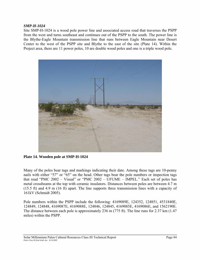
Solar Millennium Palen Cultural Resources Class III Technical Report Page 84 Palen Class III final draft .doc 8/13/2009
SMP-H-1024 Site SMP-H-1024 is a wood pole power line and associated access road that traverses the PSPP from the west and turns southeast and continues out of the PSPP to the south. The power line is the Blythe-Eagle Mountain transmission line that runs between Eagle Mountain near Desert Center to the west of the PSPP site and Blythe to the east of the site (Plate 14). Within the Project area, there are 11 power poles, 10 are double wood poles and one is a triple wood pole.
Plate 14. Wooden pole at SMP-H-1024 Many of the poles bear tags and markings indicating their date. Among these tags are 10-penny nails with either “57” or “65” on the head. Other tags bear the pole numbers or inspection tags that read “PMC 2002 – Visual” or “PMC 2002 – UFUME – IMPEL.” Each set of poles has metal crossbeams at the top with ceramic insulators. Distances between poles are between 4.7 m (15.5 ft) and 4.9 m (16 ft) apart. The line supports three transmission lines with a capacity of 161kV (Schmidt 2005). Pole numbers within the PSPP include the following: 4169089E, 124352, 124851, 4531840E, 124849, 124848, 4169087E, 4169088E, 124846, 124845, 4169085E, 4169086E, and 1562190E. The distance between each pole is approximately 236 m (775 ft). The line runs for 2.37 km (1.47 miles) within the PSPP.

Solar Millennium Palen Cultural Resources Class III Technical Report Page 85 Palen Class III final draft .doc 8/13/2009
A graded dirt road parallels the transmission line. It measures between 3.35 m (11 ft) and 4.6 m (15 ft) across at various sections and is bisected by several active alluvial washes originating from an alluvial fan at the base of the Chuckwalla Mountains to the south. Various sites are located near SMP-H-1024, including SMP-H-1001, SMP-H-1002, SMP-H-1005, SMP-H-2004, and SMP-H-2008. SMP-H-1024 does not appear on any historical topographic maps of the Project area, but the presence of nails with “57” stamped on the head would suggest that the line dates to at least 1957. It is unlikely the line was in existence before the late 1940s because the Town of Eagle Mountain, where the line terminates, was founded in 1948. While the transmission line appears to follow its original route and many of the poles appear to be original to the structure, SMP-H-1024 is recommended not eligible for inclusion in the CRHR or the NRHP. It does not contribute to the broad patterns of California history and is recommended not eligible for inclusion under CRHR Criterion 1 or NRHP Criterion A. The site is not associated with persons important to the past and is recommended not eligible for inclusion in the CRHR under Criterion 2 and NRHP under Criterion B. SMP-H-1024 does not represent a unique style, type, or design and is recommended not eligible under CRHR Criterion 3 and NRHP Criterion C. Lastly, the site is unlikely to yield information important to the past and is recommended not eligible under Criterion 4 of the CRHR or Criterion D of the NRHP. SMP-H-1025 This site consists of the remnants of U.S. Geological Survey/General Land Office (USGS/GLO) survey markers on a stable alluvial fan cut by southwest-northeast-trending ephemeral drainages. The site measures 8 m (25 ft) north-south by 60 m (190 ft) east-west. Vegetation consists of sparse creosote. Sediments are fine- to medium-grain silty sand with poorly sorted gravels and small cobbles. The geology at the site consists of sedimentary sand deposits and alluvium. The site is on an alluvial fan cut by southwest/northeast-trending ephemeral drainages. The survey markers, constructed of 2- by 4-in lumber nailed together, are buried in the ground. One stands 5 ft and the other is 12 in above the ground surface. Modern pieces of lath, wired together, are lying on the ground near a single piece of lath placed in the ground (likely related to the 2008 USGS survey). Artifacts include a broken, clear glass screw-top jar, which is adjacent to the southeastern marker. The base of the jar measures 2¾ in in diameter and is embossed with “443-16A, H4.” The site may be related to the 19th century GLO survey and subsequent updates. The site is located near the intersection of sections 3, 4, 33, and 34. Impacts at the site include minor erosion from alluvial actions associated with the alluvial fan descending from Chuckwalla Mountains. Site SMP-H-1025 is recommended not eligible for inclusion in the CRHR or the NRHP. It does not contribute to the broad patterns of history and is recommended not eligible under CRHR

Solar Millennium Palen Cultural Resources Class III Technical Report Page 86 Palen Class III final draft .doc 8/13/2009
Criterion 1 and NRHP Criterion A. The site is not related to individuals important to history and is recommended not eligible under CRHR Criterion 2 and NRHP Criterion B. The site does not represent a distinct or unique style, type, or design and is recommended not eligible under CRHR Criterion 3 and NRHP Criterion C. Site SMP-H-1025 is not likely to yield data important to history or prehistory and is recommended not eligible under CRHR Criterion 4 and NRHP Criterion D. SMP-H-1026 This resource consists of two segments of tank tracks and one segment of half-track vehicle tracks. The tracks cross a north-south-trending rocky outcrop on a stable alluvial fan. The track (T1-T3) segments measure: T1(half-track) is 53 m (175 ft) long northwest-southeast by 2.4 m (8 ft) wide with 46-cm (18-in) treads, T2 is 85 m (280 ft) long northwest-southeast by 2.8 m (9.4 ft) wide with 61-cm (24-in) treads, and T3 is 106 m (350 ft) long east-west by 2.8 m (9.4 ft) wide with 61-cm (24-in) treads. Several tracks were noted, but only three were in any condition to be accurately measured (Plate 15).
Plate 15. SMP-H-1026 facing east The vegetation includes sparse creosote. Sediments at the site are fine- to medium-grain sand with poorly sorted gravels and fist-size cobbles to small boulders. The tracks are most visible on an outcrop of younger desert pavement with no visible patination.

Solar Millennium Palen Cultural Resources Class III Technical Report Page 87 Palen Class III final draft .doc 8/13/2009
The T2 and T3 tracks match the width of M2 and M3 halftrack transports from WWII DTC activities. There are no artifacts associated with these tracks. Impacts to the site include erosion from sheet wash. Site SMP-H-1026 is recommended not eligible for inclusion to the CRHR or NRHP. It does not contribute to the broad patterns of history and is recommended not eligible under CRHR Criterion 1 and NRHP Criterion A. It is not related to the lives of individuals important to history and is recommended not eligible under CRHR Criterion 2 and NRHP Criterion B. The site does not represent a distinct or unique style, type, or design and is recommended not eligible under CRHR Criterion 3 and NRHP Criterion C. Lastly, site SMP-H-1026 is not likely to provide data important to history or prehistory and is recommended not eligible under CRHR Criterion 4 and NRHP Criterion D. SMP-H-1027 Site SMP-H-1027 is a section of Chuckwalla Valley Road located south of the PSPP. The road is a paved section of road at the base of the Chuckwalla Mountains and is the original route of U.S. Highway 60/70. Chuckwalla Valley Road is located among desert pavement-covered terraces with highly patinated surfaces. The road appears on several historic maps and at one time was the main route through the Chuckwalla Valley prior to the construction of I-10. Vegetation near the road consists of sparse creosote bushes and numerous Palo Verde trees located on the highly patinated desert pavement. There are several active alluvial washes, which Chuckwalla Valley Road crosses. Sediments nearby include poorly sorted gravels among tan to grey silty sands. The recorded segment of road includes a ROW that measures 12 m (40 ft) across and 213 m (700 ft) long trending from the northwest to the southeast. The road has been repaved and upgraded over time, but the road appears on a series of 15-minute maps including the Chuckwalla Mountains 1947 U.S. Army Map, the Palen Mountains 1943 USGS quadrangle, the 1943 Hopkins Well USGS quadrangle, and the 1952 Sidewinder Well USGS quadrangle. While the road has been upgraded and repaved over time, the road still follows the original route. Chuckwalla Valley Road is no longer within in the PSPP site due to Project redesign. As such, SMP-H-1027 was not evaluated. SMP-H-1032 Site SMP-H-1032 is a section of an unnamed historic road that traverses the PSPP. The road appears on several historic maps of the Project area. The route is a graded dirt road with several other sites nearby, including SMP-H-1008, SMP-H-1013, SMP-H-1025, SMP-H-2003, SMP-H-2007, SMP-H-2010, and SMP-H-2011/2012. The road is approximately 4.8 km (3 mile) long and measures and is between 4.6 m (15 ft) and 6 m (20 ft) wide. The road crosses several alluvial washes that originate from an alluvial fan descending from the Chuckwalla Mountains to the south. Alluvial washes originate from a series of dikes south of Chuckwalla Valley Road. The road is located on a stable portion of the alluvial

Solar Millennium Palen Cultural Resources Class III Technical Report Page 88 Palen Class III final draft .doc 8/13/2009
fan among mostly creosote bushes and desert scrub. Invasive Saharan mustard is also prevalent along the road. The road is listed on several historic maps including: the Chuckwalla Mountains 15-minute 1947 U.S. Army Map, the Palen Mountains 15-minute 1943 USGS quadrangle, the 1943 Hopkins Well USGS 15-minute quadrangle, and the 1952 Sidewinder Well 15-minute USGS quadrangle. It is possible that the road is one of the early transportation routes through the Chuckwalla Valley. It follows the same alignment as Chuckwalla Valley Road to the south. The early highway system in the United States developed out of a patchwork of trails that later became unimproved roads and eventually were connected into an integrated system of paved routes. SMP-H-1032 could be a part of the early road network in southern California. The road today is actively used by inhabitants of the Cocopah Nursery to the immediate west of the Project. Impacts to the road include those from sheet wash originating from the Chuckwalla Mountains to the south. A series of dikes to the south of Chuckwalla Valley Road form the alluvial washes present throughout the PSPP. Portions of the road have been washed away by alluvial action, though the routes remain intact. SMP-H-1032 retains integrity as a transportation route based on historic maps. However, the site is recommended not eligible for inclusion in the CRHR or the NRHP. The road may contribute to the broad patters of California’s history as a transportation route, but there is no archival evidence beyond maps from the mid-20th century indicating that it was an important route. SMP-H-1032 is recommended not eligible for inclusion in the CRHR under Criterion 1 and the NRHP under Criterion A. The site is not associated with people important to the past and is recommended not eligible for inclusion in the CRHR under Criterion 2 and the NRHP under Criterion B. The road does not represent a distinct style, type, or design and is recommended not eligible for inclusion in the CRHR under Criterion 3 and the NRHP under Criterion C. Site SMP-H-1032 has a low potential to yield information important to the past and is recommended not eligible for inclusion in the CRHR under Criterion 4 or the NRHP under Criterion D. SMP-H-2002 Site SMP-H-2002 is a widely dispersed historic refuse scatter on a southwest-northeast-trending ephemeral wash. The site measures 85 m (285 ft) north-south by 145 m (475 ft) east-west. The assemblage includes 26 tin cans and can fragments, a glass screw-top medicine bottle, clear glass fragments, and milled lumber. The site is situated on an alluvial fan descending from the Chuckwalla Mountains. The site has been severely eroded by alluvial and aeolian action and does not appear to have a subsurface component. Vegetation at the site includes sparse creosote and seasonal grasses. Sediments are fine- to medium-grain sand with poorly sorted gravels and small to medium cobbles. The geology of the site consists of a transition from stable alluvium to sedimentary sand deposits. The site is located on a southwest-northeast-trending ephemeral wash.

Solar Millennium Palen Cultural Resources Class III Technical Report Page 89 Palen Class III final draft .doc 8/13/2009
Artifacts include 26 tin cans and can fragments, an amber glass screw-top medicine bottle, clear glass fragments, and pieces of milled lumber. The tin can types include three-piece cylindrical sanitary food, beverage, oblong F style, key-opened coffee tin, and non-reclosure cans. All have crimped ends with lip-side seams. Filling methods include one hole-in-cap, three match-stick filler (milk cans), and the rest are entire-end filled. Opening methods include church-key, key strip, P38, punched hole, knife cut, and X cut. The medicine bottle measures 5½ in high by 2¼ in by 1½ in wide with a mould side seam. The intact metal cap is 1¼ in outside diameter and sits on a glass lip. A maker’s mark (the letter “I” inside an oval) and the letters/numbers “23, 7, 7 C, 51 S B 6856 – A” are embossed on the textured surface of the base. The two pieces of lumber measure 15½ in long by 5¼ in wide by 1½ in thick and 68 in long by 5 in wide by 1½ in thick. Based on the age of artifacts located at SMP-H-2002, it is likely that the site is related to DTC activities. This site appears to represent a single refuse dumping event. The presence of P38-opened cans indicates that the site is associated with military actions. The P38 was used widely during WWII as a means of opening C-rations (Moody 2008) and church-key openers came into use in 1935 (Rock 1987:112) Site SMP-H-2002 is recommended not eligible for inclusion in the CRHR or the NRHP. The site does not contribute to the broad patterns of California’s history and is recommended not eligible under CRHR Criterion 1 and NRHP Criterion A. The site is not related to individuals important to history and is recommended not eligible under CRHR Criterion 2 and NRHP Criterion B. The site does not represent a distinct or unique style, type, or design and is recommended not eligible under CRHR Criterion 3 and NRHP Criterion C. Finally, site SMP-H-2002 does not appear to posses data important to history or prehistory and is recommended not eligible under CRHR Criterion 4 and NRHP Criterion D. SMP-H-2003 The site is a very sparse historic refuse scatter on a stable alluvial fan cut by a shallow southwest-northeast-trending ephemeral wash. Site SMP-H-2003 measures 70 m (225 ft) north-south by 140 m (460 ft) east-west. The northeast portion of the site is crossed by a northwest-southeast-trending two-track dirt road (SMP-H-1032). Items reported at the site include tin cans, a condiment jar, a bottle, and bailing wire. The site is sparse and has been subjected to alluvial action and impacts from the dirt road. It does not appear to have a subsurface component. Vegetation at the site includes sparse creosote and seasonal grasses. Sediments are fine- to medium-grain sand with poorly sorted gravels and small to medium cobbles. The geology of the site consists of a transition from alluvium to sand deposits. The site is located on a southwest-northeast-trending ephemeral wash. Artifacts include 19 tin cans, a clear glass screw-cap condiment jar, an amber beverage bottle, and bailing wire from a single refuse dumping event. The tin can types include three-piece cylindrical sanitary food and motor oil, and beverage with flush or crimped ends and lip-side seams. Filling methods consist of hole-in-cap, match-stick filler, and entire-end filled. Opening methods include punched hole and church-key. The oval condiment jar measures 3½ in high by 2⅜ in by 211/16 in with a 2⅜-in opening. A geometric design is embossed on the sides of the jar
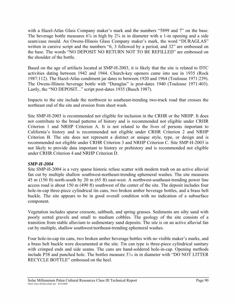
Solar Millennium Palen Cultural Resources Class III Technical Report Page 90 Palen Class III final draft .doc 8/13/2009
with a Hazel-Atlas Glass Company maker’s mark and the numbers “5899 and 7” on the base. The beverage bottle measures 6⅞ in high by 2¾ in in diameter with a 1-in opening and a side seam/case mould. An Owens-Illinois Glass Company maker’s mark, the word “DURAGLAS” written in cursive script and the numbers “6, 3 followed by a period, and 32” are embossed on the base. The words “NO DEPOSIT NO RETURN NOT TO BE REFILLED” are embossed on the shoulder of the bottle. Based on the age of artifacts located at SMP-H-2003, it is likely that the site is related to DTC activities dating between 1942 and 1944. Church-key openers came into use in 1935 (Rock 1987:112). The Hazel-Atlas condiment jar dates to between 1920 and 1964 (Toulouse 1971:239). The Owens-Illinois beverage bottle with “Duraglas” is post-dates 1940 (Toulouse 1971:403). Lastly, the “NO DEPOSIT...” script post-dates 1935 (Busch 1987). Impacts to the site include the northwest to southeast-trending two-track road that crosses the northeast end of the site and erosion from sheet wash. Site SMP-H-2003 is recommended not eligible for inclusion in the CRHR or the NRHP. It does not contribute to the broad patterns of history and is recommended not eligible under CRHR Criterion 1 and NRHP Criterion A. It is not related to the lives of persons important to California’s history and is recommended not eligible under CRHR Criterion 2 and NRHP Criterion B. The site does not represent a distinct or unique style, type, or design and is recommended not eligible under CRHR Criterion 3 and NRHP Criterion C. Site SMP-H-2003 is not likely to provide data important to history or prehistory and is recommended not eligible under CRHR Criterion 4 and NRHP Criterion D. SMP-H-2004 Site SMP-H-2004 is a very sparse historic refuse scatter with modern trash on an active alluvial fan cut by multiple shallow southwest-northeast-trending ephemeral washes. The site measures 45 m (150 ft) north-south by 20 m (65 ft) east-west. A northwest-southeast-trending power line access road is about 150 m (490 ft) southwest of the center of the site. The deposit includes four hole-in-cap three-piece cylindrical tin cans, two broken amber beverage bottles, and a brass belt buckle. The site appears to be in good overall condition with no indication of a subsurface component. Vegetation includes sparse creosote, saltbush, and spring grasses. Sediments are silty sand with poorly sorted gravels and small to medium cobbles. The geology of the site consists of a transition from stable alluvium to sedimentary sand deposits. The site is on an active alluvial fan cut by multiple, shallow southwest/northeast-trending ephemeral washes. Four hole-in-cap tin cans, two broken amber beverage bottles with no visible maker’s marks, and a brass belt buckle were documented at the site. Tin can type is three-piece cylindrical sanitary with crimped ends and side seams. The cans are hand-soldered hole-in-cap. Opening methods include P38 and punched hole. The bottles measure 37/16 in in diameter with “DO NOT LITTER RECYCLE BOTTLE” embossed on the heel.

Solar Millennium Palen Cultural Resources Class III Technical Report Page 91 Palen Class III final draft .doc 8/13/2009
Based on the age of artifacts located at SMP-H-2004, it is likely that the site is related to DTC activities occurring between 1942 and 1944. This site appears to represent a single refuse dumping event. The presence of P38-opened cans indicates that the site is associated with military actions. The P38 was used widely during WWII as a means of opening C-rations (Moody 2008). Impacts to the site include erosion from sheet wash and aeolian actions that are common to the area and appear to have redistributed artifacts since their initial deposition. Site SMP-H-2004 is recommended not eligible for inclusion in the CRHR or the NRHP. The site does not contribute to the broad patterns of history and is recommended not eligible under CRHR Criterion 1 and NRHP Criterion A. The site is not related to persons important to history and is recommended not eligible for inclusion under CRHR Criterion 2 and under NRHP Criterion B. The site does not represent a distinct or unique style, type, or design and is recommended not eligible to the CRHR under Criterion 3 and the NRHP under Criterion C. Site SMP-H-2004 has a low data potential and is not likely to yield information important to history or prehistory The site is recommended not eligible under CRHR Criterion 4 and NRHP Criterion D. SMP-H-2006 The site is a sparse historic refuse scatter on an active alluvial fan cut by shallow southwest-northeast-trending ephemeral washes. The site measures 55 m (190 ft) north-south by 105 m (355 ft) and is comprised of tin cans. Tin can types include three-piece cylindrical sanitary food, motor oil, beverage, and an oblong F style. The site appears to be in good overall condition with evidence of minor erosion. There does not appear to be a subsurface component. Vegetation includes sparse creosote, saltbush, and ironwood trees. The sediments on site are silty sands with poorly sorted gravels and small to medium cobbles. The site is on an active alluvial fan originating from the Chuckwalla Mountains and is crossed by shallow southwest-northeast-trending ephemeral washes. A total of 14 tin cans were recorded at site SMP-H-2006. Tin can types include three-piece cylindrical sanitary food and motor oil, beverage, and an oblong F style. Most have crimped ends with lip-side seams. Two cans are hand-soldered hole-in-cap. Opening methods include church-key, knife cut, P38, punched hole, tear top, and key strip. Based on the age of artifacts located at SMP-H-2006, it is likely that the site is associated with the DTC activities. This site appears to represent a single refuse dumping event. The presence of P38-opened cans indicates that the site is associated with military actions (Moody 2008). Church-key openers came into use around 1935 (Rock 1987:112), while modern key-wind-strip cans date to post-1919 (Rock 1987:59-60). Impacts to the site were observed in the form of sheet wash that appears to have redeposited the artifacts. Site SMP-H-2006 is recommended not eligible for inclusion in the CRHR or the NRHP. Site SMP-H-2006 does not contribute to the broad patterns of history and is recommended not

Solar Millennium Palen Cultural Resources Class III Technical Report Page 92 Palen Class III final draft .doc 8/13/2009
eligible for inclusion in the CRHR under Criterion 1 and the NRHP under Criterion A. The site is not related to the lives of individuals important to the past and is recommended not eligible under CRHR Criterion 2 and NRHP Criterion B. The site does not represent a distinct or unique style, type, or design and is recommended not eligible under CRHR Criterion 3 and NRHP Criterion C. Lastly, site SMP-H-2006 is unlikely to yield information important to history or prehistory and is recommended not eligible under CRHR Criterion 4 and NRHP Criterion D. SMP-H-2007 Site SMP-H-2007 is a sparse historic refuse scatter on a stable alluvial fan cut by a southwest-northeast-trending ephemeral wash. The site measures 28 m (90 ft) north-south by 60 m (200 ft) east-west. A northwest-southeast-trending two-track dirt road crosses through the center of the site (SMP-H-1032). The deposit includes tin cans, a crushed metal pail, glass fragments, shell casing, and tar. The site has been impacted by a road and minor erosion. There is no indication of a subsurface deposit. Vegetation includes sparse creosote and saltbush. Sediments in the area are fine- to medium-grain sand with poorly sorted gravels and small cobbles. The site is on an alluvial fan cut by a southwest-northeast-trending ephemeral wash. Artifacts include 11 tin cans, a crushed metal pail, 10 fragments of aqua glass, a shard of amethyst glass, a Colt 45 shell casing, and tar slag. Tin can types include three-piece cylindrical sanitary food, one beverage, a bimetal three-piece cylindrical, key-opening non-reclosure, and a square oval-end internal friction (Hershey’s Cocoa). Cans have crimped and flush ends and crimped and lip-side seams. Opening methods include tear top, key strip, punched hole, and church-key. The shell casing measures 15/16 in by ½ in in diameter. The center-fire casing has “WRA CO 45 COLT” (Winchester Repeating Arms) stamped on the end. Church-key openers came into use after 1935 (Rock 1987:112). Key-wind strip cans post-date 1919 and were widely used throughout the first half of the 20th century (Rock 1987: 56-60). Based on the age of artifacts located at SMP-H-2007, it is difficult to assign the site to a specific theme. However, the material may be associated with travel in the early part of the 20th century. This site appears to represent a single refuse dumping event. Impacts to the site include a northwest-southeast-trending two-track dirt road that crosses through the center of the site and erosion from sheet wash and aeolian action. Site SMP-H-2007 is recommended not eligible for inclusion in the CRHR or the NRHP. The site does not contribute to the broad patterns of history and is recommended not eligible for inclusion under CRHR Criterion 1 and NRHP Criterion A. The site is not related to people important to the past and is recommended not eligible for inclusion under CRHR Criterion 2 and NRHP Criterion B. The site does not represent a distinct or unique style, type, or design and is recommended not eligible under CRHR Criterion 3 and NRHP Criterion C. Site SMP-H-2007 does not appear to contain data important to history or prehistory and therefore it is recommended not eligible under CRHR Criterion 4 and NRHP Criterion D.

Solar Millennium Palen Cultural Resources Class III Technical Report Page 93 Palen Class III final draft .doc 8/13/2009
SMP-H-2008 This resource is a historic refuse scatter on an active alluvial fan cut by shallow southwest-northeast-trending ephemeral washes. The site measures 80 m (270 ft) north-south by 35 m (110 ft) east-west. The site is comprised of a concentration of about 24 tin cans and fragments of a clear glass bottle in the northeastern portion of the site (Concentration 1) surrounded by a scatter of tin cans/lids and the base of a clear glass jar further away. A northwest-southeast-trending power line access road is about 130 m (426 ft) south of the center of the can concentration. The site is in good overall condition with only minor erosion was noted. The site does not appear to have a subsurface component. Vegetation includes sparse creosote, ironwood trees, and spring grasses. Sediments are fine- to medium-grain sand with poorly sorted gravels and small to medium cobbles. The geology at the site consists of sedimentary sand deposits and alluvium. The site is on an active alluvial fan cut by shallow southwest-northeast-trending ephemeral washes. Concentration 1 is comprised of 24 tin cans and fragments of a clear glass bottle, in the northeastern portion of the site. Tin can types include three-piece cylindrical sanitary food and a two-piece oval with crimped ends and side seams, a match-stick-filled three-piece cylindrical can with flush ends and lip-side seams, and a hand-soldered hole-in-cap four-piece cylindrical can. Opening methods include P38, rotary, knife cut, and punched hole. An additional 30 tin cans/lids and the base of a clear glass jar are scattered further away from the concentration. Tin can types include three-piece cylindrical sanitary food and a beverage. All have crimped ends with crimped-side seams. Opening methods include key strip, rotary, P38, and knife cut. The jar base measures 3 in in diameter and is embossed with a Hazel-Atlas maker’s mark and the numbers “25 and 0-7350.” Based on the age of artifacts located at SMP-H-2008, it is likely that the site is related to the DTC. This site appears to represent a single refuse dumping event. The presence of P38-opened cans indicates that the site is associated with military actions since the P38 was used widely during WWII as a means of opening C-rations (Moody 2008). The Hazel-Atlas jar is dated to between 1902 and 1964 (Toulouse 1971:239). Site SMP-H-2008 is located in the 200-ft archaeological buffer and will not be impacted by construction of the PSPP. As such, it was not evaluated for inclusion in the CRHR or the NRHP. SMP-H-2009 The resource consists of a segment of northwest-southeast-trending vehicle (tank) tracks. The tracks cross a stable alluvial fan with desert pavement cut by shallow southwest-northeast-trending ephemeral drainages. The vehicle track segment measures 207 m (680 ft) long northwest-southeast by 2.7 m (9 ft) wide with 46-cm (18-in) treads. No associated artifacts were identified (Plate 16).
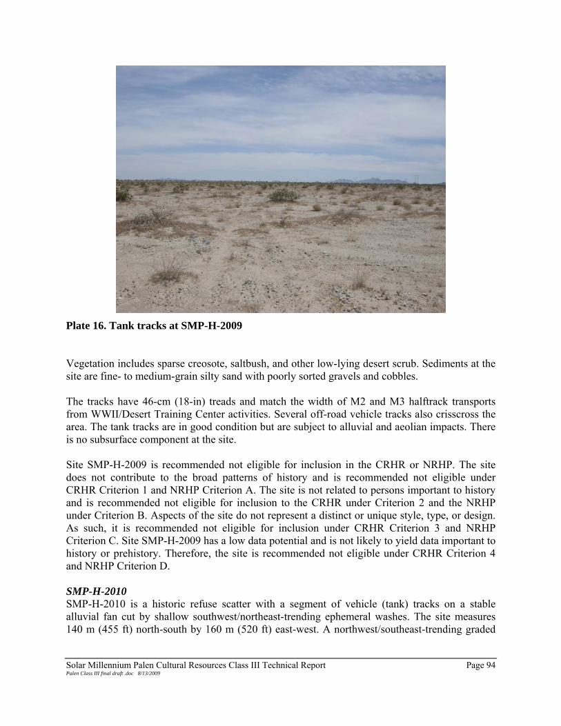
Solar Millennium Palen Cultural Resources Class III Technical Report Page 94 Palen Class III final draft .doc 8/13/2009
Plate 16. Tank tracks at SMP-H-2009 Vegetation includes sparse creosote, saltbush, and other low-lying desert scrub. Sediments at the site are fine- to medium-grain silty sand with poorly sorted gravels and cobbles. The tracks have 46-cm (18-in) treads and match the width of M2 and M3 halftrack transports from WWII/Desert Training Center activities. Several off-road vehicle tracks also crisscross the area. The tank tracks are in good condition but are subject to alluvial and aeolian impacts. There is no subsurface component at the site. Site SMP-H-2009 is recommended not eligible for inclusion in the CRHR or NRHP. The site does not contribute to the broad patterns of history and is recommended not eligible under CRHR Criterion 1 and NRHP Criterion A. The site is not related to persons important to history and is recommended not eligible for inclusion to the CRHR under Criterion 2 and the NRHP under Criterion B. Aspects of the site do not represent a distinct or unique style, type, or design. As such, it is recommended not eligible for inclusion under CRHR Criterion 3 and NRHP Criterion C. Site SMP-H-2009 has a low data potential and is not likely to yield data important to history or prehistory. Therefore, the site is recommended not eligible under CRHR Criterion 4 and NRHP Criterion D. SMP-H-2010 SMP-H-2010 is a historic refuse scatter with a segment of vehicle (tank) tracks on a stable alluvial fan cut by shallow southwest/northeast-trending ephemeral washes. The site measures 140 m (455 ft) north-south by 160 m (520 ft) east-west. A northwest/southeast-trending graded

Solar Millennium Palen Cultural Resources Class III Technical Report Page 95 Palen Class III final draft .doc 8/13/2009
dirt road cuts through the approximate center of the site (SMP-H-1032). The site includes nine features; five are rock rings/fire pits; three are survey markers; and one is a segment of tank tracks. Artifacts include numerous tin cans/lids, a glass jar, glass fragments, and whiteware and crockery fragments. The site is in good overall condition with minor erosion from sheet wash and aeolian action evident as well as disturbance from the dirt road. No subsurface component is evident. Vegetation includes sparse creosote with low-lying desert scrub, saltbush, and seasonal grasses. The site is on a stable alluvial fan cut by shallow southwest-northeast-trending ephemeral washes originating associated with washes further up the alluvial fan. Sediments are fine- to medium-grain sand with poorly sorted gravels and small to medium cobbles. Sandy soils are associated with the ephemeral drainages. The site includes nine features (Features 1-9). Features 1, 3, 4, 7, and 8 are rock rings/fire pits; Features 2, 5, and 6 are survey markers. Feature 9 is a segment of tank tracks. Feature 1 is south of the road, measures 60 by 55 in and is constructed of 28 rocks, six of which are 6 to 12 in in size. A 3-in-diameter tin can lid is in the center of the fire pit. Feature 3 is north of the road, measures 60 by 50 in and is comprised of 20 rocks with pieces of charcoal and burned wood still present. Feature 4 is north of the road and includes about 14 rocks placed in a small tight circle. A church-key-opened beverage canister is in the center of the ring. Feature 7 is south of the road, consists of six pieces of rock and measures 24 in in diameter. Feature 8 is south of the road, includes five pieces of rock and measures 35 by 20 in. Feature 2 is north of the road and consists of remnants of milled wood and twisted wire scattered in a 20-ft-diameter area. An upright piece of lumber, with wire cut nails in it, measures 3½ by 1½ in and stands 74 in above the ground surface. Also present is a 3½-in can lid and two pieces of whiteware. One piece of whiteware has a scalloped edge the other is a base fragment with a partial maker’s mark with green lettering. Feature 5 is north of the road and includes milled lumber and a long piece of wire scattered in a 10-ft-diameter area. An upright piece of lumber, measuring 3 by 5 in, stands 10 in above the ground surface. Feature 6 is also north of the road and includes pieces of milled lumber scattered in a 40- by 30-ft area. A partially intact bundle of wood lath wind fence is south of the marker. The wind fence is constructed of 3-ft lengths of lath woven together with strands of wire. An upright piece of lumber measuring 3½ by 4½ in stands 8½ in high. Feature 9 is a set of tank tracks measuring 466 ft long by 9 ft wide with 18- to 24-in treads spaced 6 ft apart. Artifacts include 111 tin cans/lids; a glass jar; aqua, green, and purple glass fragments; and whiteware and crockery fragments. Tin can types include three-piece cylindrical sanitary food, key-opening nonreclosure, oblong F style, easy-open oblong, and flat round (See Rock 1987). Most have crimped ends with lip-side seams. A few of the cans are hand-soldered hole-in-cap with a couple of match-stick filler. Opening methods include key strip, X cut, jab lift, hinge lid, twist open, church-key, knife cut, and punched hole. One small tin can embossed with

Solar Millennium Palen Cultural Resources Class III Technical Report Page 96 Palen Class III final draft .doc 8/13/2009
“BARRINGTON + HALL Soluble Coffee,” measures 2 in in diameter and ¾ in thick. A glass screw top jar, measuring 5½ in high by 4 in in diameter, embossed with “P-1048” a “Knox Glass Company” maker’s mark and a “12” on the base. Additional items include 20 fragments of whiteware, found in a 3-ft-diameter area; pieces of a crock-pot (base and lip fragments); a discrete deposit of fragments from a purple glass bottle (19 pieces); another cluster of purple glass (25 pieces) containing rim shards and a base fragment; fragments (20 pieces) of two green glass bottles; and fragments of two amber glass bottles. Based on the age of artifacts located at SMP-H-2010, it is likely that the site is related to the DTC. It is also possible that some artifacts from the site date to earlier dumping episodes, possibly related to travel on the road earlier in the 20th century. This site appears to represent multiple episodes of refuse dumping over a span of several years, possibly including military, camping, and land survey. Artifacts at the site date to various time periods. Church-key openers came into use in 1935 (Rock: 1987:112), while the Knox Glass Company jar dates to 1956 and after (Toulouse 1971:293). The presence of fire pits may indicate camping or refuse burning in the area while tank tracks suggest DTC activities. Survey markers present at SMP-H-2010 are perhaps remnants of USGS/GLO survey markers. Portions of the site may be related to the 19th century GLO survey and subsequent updates. Impacts to the site include a northwest-southeast-trending two-track dirt road that cuts through the approximate center of the site as well as continued erosion from sheet wash and aeolian action. Site SMP-H-2010 is recommended not eligible for inclusion in the CRHR or the NRHP. The site does not contribute to the broad patterns of history and is recommended not eligible under CRHR Criterion 1 and NRHP Criterion A. The site is not related to persons important to history and is recommended not eligible under CRHR Criterion 2 and NRHP Criterion B. The site does not represent a distinct or unique style, type, or design and is recommended not eligible under CRHR Criterion 3 and NRHP Criterion C. Site SMP-H-2010 is not likely to provide data important to history or prehistory and is recommended not eligible under CRHR Criterion 4 and NRHP Criterion D. SMP-H-2011/2012 Site SMP-H-2011/2012 is a historic refuse scatter with two segments of vehicle (tank) tracks on a stable alluvial fan cut by shallow southwest-northeast-trending ephemeral washes. The site measures 90 m (285 ft) north-south by 245 m (805 ft) east-west. A southwest-northeast-trending graded dirt road cuts through the southeastern edge of the site and a northwest-southeast-trending two-track road cuts through the approximate center of the site (SMP-H-1032). Artifacts include 60 tin cans/lids, a 6-oz. Coca-Cola (Coke) bottle, fragments of an amber glass jug (Purex), a pocketknife, and a spark plug. Modern debris has also been dumped in the southeastern end of the site. The site appears in good overall condition with impacts evident from the roads, recent dumping, minor erosion from sheet wash, and aeolian action. There appears to be no subsurface component to the site.

Solar Millennium Palen Cultural Resources Class III Technical Report Page 97 Palen Class III final draft .doc 8/13/2009
Vegetation includes sparse creosote and spring grasses. Sediments at the site are tan to grey silty sand with poorly sorted gravels and small to medium cobbles. The site is on a alluvial fan that transitions to sandy dunes approaching the playa shore. The site is cut by shallow southwest-northeast-trending ephemeral washes. The site is an elongated refuse scatter with two segments of vehicle (tank) tracks. The northwest-southeast-trending tracks are along the southwestern margins of the site. The main track segment measures about 130 m (430 ft) long by 2.4 m (8 ft) wide with 24-in treads. A shorter, east-west-trending segment, measuring 43 m (140 ft) long and 2.4 m (8 ft) wide with 24-in treads, intersects the main segment approximately 50 m (165 ft) from the southeastern end of the main segment. Artifacts include 60 tin cans/lids, a 6 oz. Coca-Cola bottle, fragments of an amber glass one-gallon jug (Purex), a pocketknife, and a sparkplug. Tin can types include two- and three-piece cylindrical sanitary food, beverage, key-opening nonreclosure, and hinge-lid pocket (tobacco tins). The cans have crimped and flush ends with lip-side seams and machine soldered. A few of the cans are hand-soldered hole-in-cap. Opening methods include key strip, punched hole, and circle slice. Many of the cans are crushed. The Coke bottle has “Los Angeles” written on the base. The pocketknife has a 3¾-in blade (rusted) (Plate 17). The sparkplug is ceramic and measures 3 in long with the words “Champion/Ford” written on the side (Plate 18). Modern debris has also been dumped at the southeastern end of the site near the graded dirt road.
Plate 17. Pocketknife at SMP-H-2011/2012

Solar Millennium Palen Cultural Resources Class III Technical Report Page 98 Palen Class III final draft .doc 8/13/2009
Plate 18. Sparkplug at SMP-H-2011/2012 Based on the age of artifacts located at SMP-H-2011/2012 is likely a single event deposit related to DTC military training activities dating to the 1940s, followed by more recent deposits. Pocket tobacco tins began being manufactured in 1908 and were used throughout the first half of the 20th century (Rock 1987:62). Champion/Ford spark plugs have a wide date range, including during WWII. The tank tracks have treads and match the width of M2 and M3 halftrack transports from DTC activities (Meller 1946). Impacts include the roads, modern refuse dumping, and erosion from sheet wash. Site SMP-H-2011/2012 is recommended not eligible for inclusion in the CRHR or NRHP The site does not contribute to the broad patterns of history and is recommended not eligible under CRHR Criterion 1 and NRHP Criterion A. The site is not related to persons important to history and is recommended not eligible under CRHR Criterion 2 and NRHP Criterion B. The site does not represent a distinct or unique style, type, or design and is recommended not eligible under CRHR Criterion 3 and NRHP Criterion C. Site SMP-H-2011/2012 possess a low data potential and is recommended not eligible under CRHR Criterion 4 and NRHP Criterion D.

Solar Millennium Palen Cultural Resources Class III Technical Report Page 99 Palen Class III final draft .doc 8/13/2009
SMP-P-2013A Site SMP-P-2013A is a temporary campsite comprised of a hearth (Feature 1) and lithics, including an obsidian flake, a metavolcanic tool (chopper), and a metavolcanic core. Groundstone artifacts include a metavolcanic metate and a possible tabular basalt metate. No faunal remains were noted on the surface. The site is located among sand dunes.. The site encompasses an area measuring 55 m (180 ft) north-south by 30 m (100 ft) east-west. Feature 1 is comprised of a concentration of FAR in a 5-by-3.5-m area. The FAR consists of metavolcanic, basalt, and granitic rocks. Outlying artifacts in addition to those listed above include several fragments of tortoise shell, two of which were burned. Vegetation includes sparse saltbush and creosote with very small low bunch grasses and invasive Saharan mustard. The surrounding area is comprised mostly stable dunes. The site is subject to shifting sand and erosion. Sediments are very light tan fine- to coarse-grain sand. No naturally occurring rocks are present in the vicinity. Impacts to the site are associated with aeolian impacts that may have partially buried the site. Because the site is located among shifting sands, a subsurface component is possible at SMP-P-2013a. SMP-P-2013a was identified during Class III surveys for the PSPP. However, redesigned Project plans place the site outside the Project area. As such, the site was not evaluated for inclusion in the CRHR or the NRHP. SMP-P-2013B The site SMP-P-2013B is a low-density lithic scatter with a possible hearth consisting of FAR on a west-facing stabilized dune. The site is located on the lower part of an alluvial fan near the shoreline of Palen Dry Lake. Artifacts include a basalt projectile point fragment, a metavolcanic core, a core fragment, and a primary flake. No faunal remains were identified at the site. The site encompasses an area measuring 35 m (115 ft) north-south by 22 m (72 ft) east-west (Plate 19). The basalt projectile point is the distal end and weathered. It is located approximately 23 m (75 ft) south from the site datum and measures 1.8 mm by 1.4. mm by 0.4 mm. Flakes are concentrated in two areas (Concentration 1 and Concentration 2). Two core fragments were also noted at the site, measuring 12 mm and 15.5 mm respectively. Vegetation includes sparse saltbush and creosote with very small low bunch grasses. The surrounding area is similar. The site is appears largely undisturbed except for some erosion and deflation. Sediments are very light tan fine- to coarse-grain sand in the northern portion with deflated reddish sandy silt in the southern portion of the site. No naturally occurring rocks are present in the vicinity. The site is located on the edge of the Palen playa.

Solar Millennium Palen Cultural Resources Class III Technical Report Page 100 Palen Class III final draft .doc 8/13/2009
Plate 19. FAR at site SMP-P-2013B Concentration 1 is located in the northeastern part of the site and measures 3 m north-south by 3 m east-west and is comprised of approximately 10 primary flakes. Concentration 2 measures 1 m north-south by 1 m east-west and has approximately 10 flakes. It is located at the extreme northeastern edge of the site. Two cores are located to the north and northeast of Concentration 1. Impacts to the site include aeolian and alluvial impacts associated with dunes near the Palen Dry Lake playa. A two-track road is located approximately 12 m south of the southern edge of the site. Based on surface conditions at SMP-P-2013b, it appears that a subsurface component may exist at the site. Given the potential for a subsurface deposit, the site could contribute information relevant to sites along prehistoric lakes in the Colorado Desert (see Research Issues above). Site SMP-P-2013b is located in the 200-ft archaeological buffer and will not be impacted by construction of the PSPP. As such, it will not be evaluated for inclusion in the CRHR or the NRHP. SMP-P-2014 Prehistoric site SMP-P-2014 is a low density lithic scatter located on a stable dune south of Palen Dry Lake. The site assemblage includes a core and several flakes. The site rests among sparse saltbush and creosote with very small low-lying bunch grasses and invasive Saharan mustard.

Solar Millennium Palen Cultural Resources Class III Technical Report Page 101 Palen Class III final draft .doc 8/13/2009
Site SMP-P-2014 sits at the base of an alluvial fan originating from the Chuckwalla Mountains to the south. The site is appears largely undisturbed except for some erosion and deflation. Sediments are tan fine-grain silty sands with gravels and small cobbles. The site measures 30 m (100 ft) north-south by 20 m (65 ft) east-west. There are a total of four artifacts at the site: one metavolcanic core and three flakes. The core measures 18 mm by 10 mm by 10 mm. There are two primary flakes and one secondary flake, all of which are metavolcanic. Flakes range in size from 5 mm to 45 mm. No concentrations of artifacts were noted at the site. The site is located on a stable, but deflating dune terrace. Impacts to the site can be attributed to aeolian and alluvial actions common to the area. Based on observed surface conditions, there is a possibility that a subsurface component exists at SMP-P-2014. In addition, the site has the potential to yield information about the playa region of the Chuckwalla Valley and is recommended potentially eligible for inclusion to the CRHR and the NRHP. Site SMP-P-2014 does not contribute to the broad patterns of history and is recommended not eligible under Criterion 1 for inclusion to the CRHR under Criterion A for the NRHP. The site is not associated with individuals important to the past and is recommended not eligible for inclusion to the CRHR under Criterion 2 and to the NRHP under Criterion B. Artifacts at the site do not represent a distinct style, type, or design and the site is recommended not eligible for inclusion to the CRHR under Criterion 3 or the NRHP under Criterion C. The site appears to have a limited data potential and is not eligible for inclusion to the CRHR under Criterion 4 and is unevaluated for inclusion to the NRHP under Criterion D. The site does appear to qualify to be addressed under CARIDAP. Successful treatment under CARIDAP would result in a no historic property affected determination. Based on observed surface conditions, there is a possibility that a sub-surface component exists at SMP-P-2014. In addition, the site has the potential to yield information about the playa region of the Chuckwalla Valley and is recommended potentially eligible for inclusion to the CRHR and the NRHP. Site SMP-P-2014 does not contribute to the broad patterns of history and is recommended not eligible under Criterion 1 for inclusion to the CRHR under Criterion A for the NRHP. The site is not associated with individuals important to the past and is recommended not eligible for inclusion to the CRHR under Criterion 2 and to the NRHP under Criterion B. Artifacts at the site do not represent a distinct style, type, or design and the site is recommended not eligible for inclusion to the CRHR under Criterion 3 or the NRHP under Criterion C. The site appears to have a limited data potential and is not eligible for inclusion to the CRHR under Criterion 4 and is unevaluated for inclusion to the NRHP under Criterion D. The site does appear to qualify to be addressed under CARIDAP. Successful treatment under CARIDAP would result in a no historic property determination.

Solar Millennium Palen Cultural Resources Class III Technical Report Page 102 Palen Class III final draft .doc 8/13/2009
SMP-P-2015 Site SMP-P-2015 is a lithic and groundstone scatter (Plate 20). The site features a metate, a metate fragment, and a ground boulder. There is also a core, a domed scraper, and biface among a scatter of flakes. The site is located on a stable dune with low deflating to deflated slopes. The site is sloping to the northeast. The site encompasses a 47 m (155 ft) north-south by 22 m (72 ft) east-west area with a lithic concentration (Concentration 1) measuring 20 m (65 ft) north-south by 11.5 m (38 ft) east-west.
Plate 20. SMP-P-2015 facing southeast The site is located on at the base of an alluvial fan. The surrounding area is comprised of very sparse creosote among low-lying desert grasses and invasive Saharan mustard (which is dominant at the site). Sediments at the site are tan fine-grain silty sand with gravels and small cobbles over reddish sandy silt. Artifacts in Concentration 1 include a metavolcanic core, 19 metavolcanic flakes (primary and secondary), 15 CCS flakes (primary and secondary), a CCS domed scraper, and an extremely weathered basalt biface base fragment. Outlying artifacts are located to the east and south of the Concentration 1. Groundstone artifacts include four pieces of a granitic metate, a boulder with a ground surface, and fragments of marine shell scattered throughout the site.

Solar Millennium Palen Cultural Resources Class III Technical Report Page 103 Palen Class III final draft .doc 8/13/2009
The site appears largely undisturbed except for some erosion and deflation due to aeolian actions that is common to the area. It is possible that there is a subsurface component to the site that has been buried by aeolian impacts. Based on its condition and possibility of contributing important information about the past, the site is recommended potentially eligible for inclusion in the CRHR and the NRHP. The site does not contribute the broad patterns of California’s history and is recommended not eligible for inclusion in the CRHR under Criterion 1 and the NRHP under Criterion A. Site SMP-P-2015 is not associated with individuals important to the past and is recommended not eligible for inclusion in the CRHR under Criterion 2 and the NRHP under Criterion B. Elements of the site do not represent a distinct style, type, or design and the site is recommended not eligible for inclusion in the CRHR under Criterion 3 and the NRHP under Criterion C. The site does have the potential to contribute information important to history or prehistory based on its possible subsurface component and is recommended potentially eligible for inclusion in the CRHR under Criterion 4 and is unevaluated for inclusion to the NRHP under Criterion D. SMP-H-2016 The site is a historic corral with seven features on a stable alluvial fan and dune terrace. The site measures 390 ft (119 m) northeast-southwest by 230 ft (70 m) northwest-southeast. A northwest to southeast-trending two-track road provides access to the site but continues through the south-central portion of the site and beyond. The site includes seven features; a corral; two remnant plywood structures; a 2008 USGS survey marker; two concentrations of construction materials; and a modern rock ring. The features appear to span several years with multiple deposits. Impacts include the road, recent dumping, minor erosion from sheet wash, and aeolian action. There does not appear to be a subsurface component to the site. The USGS survey marker, in the east-central portion of the site just north of the two-track road is the site datum. Vegetation includes sparse creosote and spring grasses among low-lying desert scrub and invasive Saharan mustard. Sediments are fine- to medium-grain silty sand with poorly sorted gravels and pebbles. The site is on an alluvial fan. There are seven features (Features 1-7) Features 1 through 4 and Feature 7 are north of the two-track road, Feature 5 and Feature 6 are south of the road. Feature 1 includes the remains of a corral, a stack of coiled barbed wire, a rock ring, a deposit of partial sheets of plywood, milled lumber, composite shingles, and a metal cylinder (Plate 21). The corral is constructed of 4- by 3½-in wood posts braced by 3¼-in-square lumber of varying lengths. The southwest, southeast, and northeast corner posts are still standing; the northwest corner has collapsed. There are remnants of white paint on some of the corner posts. Portions of the corral are still covered with 5 ft high 4- by 6-in wire mesh fencing attached with U-shaped fastener. The rock ring (likely historic) includes eight pieces of FAR and measures 3½ ft by 2 ft. The welded metal cylinder measures 18 in high by 14 in in diameter and is constructed of ¼-in steel. The cylinder is full of bullet holes. Feature 2 and Feature 3 are remnant structures (collapsed sheds) constructed of sheets of plywood, various lengths of dimensional lumber, and wire cut nails (some are galvanized nails). Pieces of composite shingles (1 ft by 9 in) were also noted. Feature 2 measures 21 ft east-west by 18 ft north-south. The dimensions of Feature 3 are 11 ft east-west by 8 ft

Solar Millennium Palen Cultural Resources Class III Technical Report Page 104 Palen Class III final draft .doc 8/13/2009
north-south. Feature 4 is a recent USGS survey marker (2008 date, T 5S R 17E). The marker is a brass cap with a 2½-in-diameter galvanized metal pipe standing 14½ in above the ground. A wooden stake (lath) and remnants of lath are nearby. Feature 5 is a concentration of milled lumber, plywood, composite shingles, and two rock rings. The deposit measures about 42 ft in diameter. There are two rock rings within Feature 5, one consist of 10 rocks in a rough circle measuring 3 ft by 2½ ft. The other consists of six rocks in a rough circle measuring 3 ft by 2 ft. Feature 6 is a large concentration of various lengths of milled lumber, two discrete deposits of wire-cut and square nails, and composite shingles with roofing nails. The feature measures 180 ft east-west by 25 ft north-south. Feature 7 is a modern rock ring measuring 3½ ft in diameter and constructed of 35 rocks.
Plate 21. SMP-H-2016 facing north Artifacts include two tin cans (church-key-opened beverage cans), one rotary-opened can lid, various sizes of milled lumber, and wire-cut and square nails. Based on the age of artifacts located at SMP-H-2016, the site appears to date to the early- to mid-20th century, but no definite date can be assigned. The wire corral and associated plywood sheds suggest ranching activity. Church-key can openers came into use in 1935 (Rock 1987:112). Wire-cut nails are modern while square nails date from the 19th century, though nails are often re-used in the archaeological record.

Solar Millennium Palen Cultural Resources Class III Technical Report Page 105 Palen Class III final draft .doc 8/13/2009
Site SMP-H-2016 is recommended not eligible for inclusion in the CRHR or the NRHP. The site does not contribute to the broad patterns of history and is recommended not eligible under CRHR Criterion 1 and NRHP Criterion A. The site is not related to persons important to history and is recommended not eligible under CRHR Criterion 2 and NRHP Criterion B. The site does not represent a distinct or unique style, type, or design and is recommended not eligible under CRHR Criterion 3 and NRHP Criterion C. Site SMP-H-2016 is not likely to provide data important to history or prehistory and is recommended not eligible under CRHR Criterion 4 and NRHP Criterion D. SMP-H-2017 Site SMP-H-2007 is a low density of historic debris on an alluvial fan. The site measures 25 m (80 ft) north-south by 20 m (65 ft) east-west. An old northwest to southeast-trending two-track road is just south of the site. A concentration of tin cans and lids is at the southern edge of the site, just southeast of the datum. Artifacts consist of eight tin cans and three can lids. The potential for a subsurface component exists due to sandy sediments. Vegetation includes sparse creosote among seasonal spring grasses, low-lying desert scrub, and invasive Saharan mustard. Sediments are fine- to medium-grain silty sand that is tan to grey with poorly sorted gravels and pebbles. A concentration of tin cans and lids is located at the southern edge of the site, just southeast of the datum (Concentration 1). Artifacts in Concentration 1 consist of six tin cans. Other artifacts at the site include three can lid fragments, a key-strip-opened meat tin, and a food canister. Two addition tin cans were found outside of the concentration. Can types include a three-piece cylindrical internal friction sanitary food and an oblong key-opened hole-in-cap meat tins. Based on the age of artifacts, SMP-H-2017 is a single event deposit. Can types present appear to date to the early 20th century (Rock 1987:113). Impacts observed at the site appear to originate from aeolian action that has shifted sandy sediments and redistributed artifacts. Site SMP-H-2017 is recommended not eligible for inclusion in the CRHR or the NRHP. The site does not contribute to the broad patterns of California’s history and it is recommended not eligible under CRHR Criterion 1 and NRHP Criterion A. The site is not related to individuals important to California’s past and is recommended not eligible under CRHR Criterion 2 and NRHP Criterion B. The site does not represent a distinct or unique style, type, or design and is recommended not eligible for inclusion in the CRHR under Criterion 3 and the NRHP under Criterion C. Site SMP-H-2017 is unlikely to provide information important to history or prehistory and is recommended not eligible under CRHR Criterion 4 and NRHP Criterion D. SMP-P-2018 The prehistoric site is a low-density lithic scatter with five clusters of FAR (Features 1-5) on a low north-sloping stabilized dune. Artifacts include a metavolcanic primary flake, a CCS biface-

Solar Millennium Palen Cultural Resources Class III Technical Report Page 106 Palen Class III final draft .doc 8/13/2009
thinning flake, a quartz secondary flake, a metavolcanic hammerstone/battered cobble, and a metavolcanic test cobble. A rusted machine-oil can was also noted on the site. The site encompasses an area measuring 54 m (177 ft) north-south by 28 m (92 ft) east-west (Plate 22). Vegetation includes sparse saltbush and creosote with small low bunch grasses and invasive Saharan mustard. Sediments are tan fine-to medium-grain silty sand with gravels and small cobbles. The site is located at the base of an alluvial fan originating from the Chuckwalla Mountains. The surrounding dune terraces are part of a transitional zone from the stable alluvial fan to the playa shoreline.
Plate 22. SMP-P-2018 facing south Feature 1 is a concentration of FAR located to the immediate southeast of the datum (a creosote bush at the center near the center of the site). The feature measures 2 m across by 65 cm across and contains nine pieces of basalt FAR. Feature 2 is located at the northern edge of the site and contains approximately 40 rocks. Most of the rocks are granitic with several metavolcanics. Approximately 20 percent of the rocks in the feature are burned. Feature 3 is located approximately 10 m (33 ft) south-southwest of Feature 2 and includes approximately 10 pieces of granitic and metavolcanic FAR over a 1 m by 1.5 m area.

Solar Millennium Palen Cultural Resources Class III Technical Report Page 107 Palen Class III final draft .doc 8/13/2009
Feature 4 consists of an FAR concentration measuring 3 m by 2 m. The feature is located on a mound that measures roughly 5.5 m by 5.5 m and recently burned roots, charcoal, and wood are evident on the surface. The mound has approximately 42 angular granitics and metavolcanics ranging in size from as large as 40 cm in length to less than 5 cm. Feature 5 is a 1.1 m by 1.5 m FAR feature consisting of approximately 25 metavolcanic and granitic rocks, most of which show evidence of burning. Six rocks in the feature are at least 20 cm in length. The remaining FAR at the feature measures between 3 and 7 cm. Outlying artifacts include a tested CCS battered stone, a grey metavolcanic tested cobble, a brown CCS biface-thinning flake, and a quartz secondary flake. The site appears to have been disturbed by track vehicle activity north of Feature 1. Other impacts may be associated with deflating dune surfaces due to aeolian actions common to the area. Portions of the site appear to have been buried by aeolian action. SMP-P-2018 is located in the 200-ft archaeological survey buffer and will not be impacted by construction of the PSPP. As such, it was not be evaluated for inclusion in the CRHR or the NRHP. SMP-H-2019 The site is a sparse historic refuse scatter on an active alluvial fan flanked by multiple southwest/northeast-trending washes. The site measures 130 m (420 ft) north-south by 50 m (165 ft) east-west. A north/south-trending two-track dirt road is just west of the site. Artifacts consist of tin cans, a medicine bottle, and a whiskey bottle. The site is in good overall condition with some erosion by sheet wash and aeolian action. There does not appear to be a subsurface component to the site. Vegetation includes sparse creosote and low-lying desert scrub with spring grasses and invasive Saharan mustard. Sediments include fine- to medium-grain sand with poorly sorted gravels. The geology is sedimentary sand deposits and alluvium originating from an alluvial fan at the base of the Chuckwalla Mountains. The site rests on an active alluvial fan flanked by multiple southwest-northeast-trending washes. Artifacts consist of 21 tin cans, a small medicine bottle, and a screw-top whiskey bottle. Tin can types include three-piece cylindrical sanitary food and motor oil, beverage, and a pear-shaped meat (ham) tin. Canisters have crimped and flush ends and lip-side seams. Opening methods include church-key, P38, knife cut, bayonet, and punched hole. Three of the cans are match-stick filled. The medicine bottle measures 2 in high by ¾ in wide. The screw-top whiskey bottle measures 6 in high by 4 in wide. Based on the age of artifacts located at SMP-H-2019, it is likely that the site is related to DTC activities. This site appears to represent a single refuse dumping event. The P38 was used widely during WWII as a means of opening C-rations (Moody 2008). Church-key openers came into use in 1935 (Rock 1987:112).

Solar Millennium Palen Cultural Resources Class III Technical Report Page 108 Palen Class III final draft .doc 8/13/2009
Impacts at the site seem to be associated with sheet wash that may have redeposited artifacts since original deposition. Site SMP-H-2019 is recommended not eligible for inclusion in the CRHR or the NRHP.. The site does not contribute to the broad patterns of history and is recommended not eligible under CRHR Criterion 1 and NRHP Criterion A. The site is not related to persons important to history and is recommended not eligible under CRHR Criterion 2 and NRHP Criterion B. The site does not represent a distinct or unique style, type, or design and is recommended not eligible under CRHR Criterion 3 and NRHP Criterion C. Site SMP-H-2019 does not appear to possess data important to history or prehistory and is recommended not eligible under CRHR Criterion 4 and NRHP Criterion D. SMP-H-2020 The resource is a segment of northeast-southwest-trending tank tracks on a flat gravel terrace likely dating to the DTC from between 1942 and 1944. The tracks run for approximately 76 m (250 ft) and measure 2.7 m (9 ft) wide, and the track width is approximately 50 cm (20 in). The tracks have good integrity with minor erosion but no associated artifacts and no subsurface component. The datum is a creosote bush on the western side of the tracks. The linear resource is on a less developed portion of desert pavement consisting of a flat gravel terrace. The vegetation includes sparse saltbush, creosote, and low bunch grasses. Sediments are fine- to medium-grain sand with gravels and small cobbles. No patinated surfaces are visible on the pavement as the tracks cross an alluvial fan and disappear. The surface on which the tracks are located is subject to erosion, deflation, and sheet wash originating from the base of the Chuckwalla Mountains to the south. Sheet wash has eroded the tracks to the northeast and the southwest. Site SMP-H-2020 is recommended not eligible for inclusion to the CRHR or NRHP. The site does not contribute to the broad patterns of history and is recommended not eligible for inclusion to the CRHR under Criterion 1 and the NRHP under Criterion A. The site is not related to the lives of individuals important to history and is recommended not eligible under CRHR Criterion 2 and NRHP Criterion B. The site does not represent a distinct or unique style, type, or design and is recommended not eligible under CRHR Criterion 3 and NRHP Criterion C. Lastly, site SMP-H-2020 is not likely to yield information important to history or prehistory and recommended not eligible under CRHR Criterion 4 and NRHP Criterion D. SMP-H-2021 Site SMP-H-2021 is an historic debris scatter in an ephemeral alluvial wash and stable alluvial fan cut by shallow southwest-northeast-trending washes. The site measures 55 m (180 ft) north-south by 115 m (375 ft) east-west. The site consists of two tin can concentrations with a few additional cans scattered between them. The artifact assemblage is comprised of tin cans and an enameled-metal bowl. The site has been impacted by erosion from sheet wash and aeolian action and does not appear to have a subsurface component.

Solar Millennium Palen Cultural Resources Class III Technical Report Page 109 Palen Class III final draft .doc 8/13/2009
Vegetation includes sparse creosote, low-lying desert grasses, and invasive Saharan mustard. Sediments in the area are silty sands that are generally well-sorted with some small gravels and cobbles. The site is located near the transitional zone of the stable alluvial fan and the sandy dunes south of Palen Dry Lake. The site rests in an ephemeral southwest-northeast trending alluvial wash. There are two tin can concentrations. Concentration 1 is in the southwestern portion of the site, and Concentration is in the eastern portion of the site. Concentration 1 measures 11 m (35 ft) northeast-southwest by 7 m (22.5 ft) northwest-southeast and contains four three-piece cylindrical containers and a church-key opened beverage canister. All of the cans are machine soldered. There is one match-stick filled can. Several of the cans are crushed or fragmentary. Concentration 2 measures 20 m (66 ft) east-west by 13 m (42 ft) north-south and consists of eight three-piece cylindrical containers, six key-opening nonreclosure containers, and an enameled-metal bowl. All of the cans are machine soldered. Can opening methods include punched hole, X or T cut, and key strip (Plate 23). Five of the cans are match-stick filled and six are hole-in-cap. Three of the hole-in-cap cans are key-strip opened and have “Brazil Inspeccionado” written on top of the can. The grey enameled bowl measures 53/16 in across the top, 3⅝ in across the base, and 2 in high. A U-shaped handle has broken off the side of the bowl.
Plate 23. X-cut can at SMP-H-2021

Solar Millennium Palen Cultural Resources Class III Technical Report Page 110 Palen Class III final draft .doc 8/13/2009
Artifacts outside of the concentration include 12 tin cans. Tin can types include three-piece cylindrical sanitary food containers and beverage canisters with crimped and flush ends and lip-side seams. All of the cans are machine soldered. Opening methods include jab lift, church-key, and punched hole. Five of the cans are match-stick filled. Based on the age of artifacts located at SMP-H-2021, it is likely that the site is related to DTC activities dating to between 1942 and 1944. This site appears to represent a single refuse dumping event. Church-keys became used as openers in 1935 (Rock 1987:112) and key-wind-strip cans were in active use in California since around 1919 (Rock 1987:59). Other can-opening methods observed at the site date from the 19th century into the mid-20th century (Rock 1987:113). Site SMP-H-2021 is recommended not eligible for inclusion in the CRHR or the NRHP. It does not contribute to the broad patterns of history and is recommended not eligible under CRHR Criterion 1 and NRHP Criterion A. The site is not related to persons important to history and is recommended not eligible under CRHR Criterion 2 and NRHP Criterion B. The site does not represent a distinct or unique style, type, or design and is recommended not eligible under CRHR Criterion 3 and NRHP Criterion C. Site SMP-H-2021 is not likely to provide data important to history or prehistory and is recommended not eligible under CRHR Criterion 4 and NRHP Criterion D. SMP-H-2022 Site SMP-H-2022 is a very sparse historic debris scatter in an active deflating dune field. The site measures 20 m (60 ft) north-south by 10 m (30 ft) east-west. A concentration, containing eight tin cans, is in the northeastern portion of the site. Artifacts outside of the concentration consist of 11 tin cans and bailing wire. The site has been impacted by erosion from sheet wash and aeolian action and does not appear to have a subsurface component. Vegetation includes sparse creosote, low-lying grasses, and invasive Saharan mustard. Sediments are fine- to medium-grain silty sands with poorly sorted gravels with one small boulder noted in the southeastern end of the site. The site is near an actively deflating dune field south of Palen Dry Lake. One refuse concentration (Concentration 1) measuring 15 ft east-west by 10 ft north-south contains six, church-key-opened hole-in-cap cans and two circle-slice opened food canisters. All of the cans are three-piece cylindrical sanitary with crimped ends and lip-side seams. Artifacts outside of the concentration include two church-key-opened hole-in-cap cans, one of which is crushed, and a circle-slice-opened sanitary food canister. The tin cans are three-piece cylindrical sanitary with crimped ends and lip-side seams. A 2 ft length of bailing wire is in the southeast portion of the site near a small boulder. Based on the age of artifacts located at SMP-H-2022, it is likely that the site dates to the DTC. Artifacts, such as church-key-opened beverage cans, appear to be from a single refuse dumping event. Church-key openers came into use in 1935, several years before the DTC, and circle-slice-

Solar Millennium Palen Cultural Resources Class III Technical Report Page 111 Palen Class III final draft .doc 8/13/2009
opened cans become less frequent during the 1930s (Rock 1987). The presence of both types of can openings indicate that the site dates to the late 1930s or early 1940s. Site SMP-H-2022 is recommended not eligible for inclusion to the CRHR or NRHP. The site does not contribute to the broad patterns of history and is recommended not eligible under CRHR Criterion 1 and NRHP Criterion A. The site is not related to persons important to history and is recommended not eligible under CRHR Criterion 2 and NRHP Criterion B. The site does not represent a distinct or unique style, type, or design and is recommended not eligible under CRHR Criterion 3 and NRHP Criterion C. Site SMP-H-2022 has a low data potential and recommended not eligible under CRHR Criterion 4 and NRHP Criterion D. SMP-P-2023 The site is a temporary camp site with associated groundstone and lithics that measures 75 m (246 ft) north-south by 16 m (52 ft) east-west. A discrete scatter of FAR (Feature 1) (Plate 24) is located near the center of the site. Outlying artifacts include fragments of at least five metates, a single granitic mano, two flakes, and one core. No faunal remains were noted at the site. The datum of the site is a creosote bush immediately east of Feature 1.
Plate 24. FAR at SMP-P-2023

Solar Millennium Palen Cultural Resources Class III Technical Report Page 112 Palen Class III final draft .doc 8/13/2009
Site SMP-P-2023 is located on an alluvial fan that descends from the Chuckwalla Mountains. Vegetation on the site includes creosote and low-lying desert scrub as well as spring grasses and invasive Saharan mustard. Feature 1 is a discrete scatter of FAR measuring 1 m north-south by 1 m east-west and includes six visible pieces of far between 7 cm and 10 cm in size. Feature 1 is partially buried under sandy sediments and is located at the base of a creosote bush. A subsurface element of Feature 1 appears possible based on observed surface conditions. Outlying artifacts include groundstone fragments of five metates, a mano, a core, and two flakes (one quartz and one CCS). The unifacial granitic mano is located approximately 36 m to the southeast of the datum and measures 15 cm by 10 cm. Two flakes at the site are a primary CCS flake and a secondary quartz flake located approximately 20 m north-northwest of the datum. The core is located 3 m south of the datum. It is metavolcanic and shows evidence of battering. Eight fragments from five granitic metates are located throughout the site. One is approximately 4 m south of the datum and includes three fragments from a single metate. A second metate fragment is 9 m south of the datum. The third is a single fragment 12 m north of the datum. The fourth metate is in five pieces and is located approximately 15 m northeast of the datum. The final metate is located approximately 30 m southeast of the datum at the edge of the site. Site SMP-P-2023 is a temporary camp with the remnants of a hearth feature and associated artifacts. No midden or charcoal was noted based on surface conditions, but a subsurface deposit may exist. Fragmentary metates could indicate that the site was used for a prolonged period of time or may have been returned to by inhabitants from season to season or year to year. Based on surface observations, site SMP-P-2023 is recommended potentially eligible for inclusion to the CRHR and the NRHP. The site does not contribute to the broad patterns of history and is recommended not eligible for inclusion in the CRHR under Criterion 1 and the NRHP under Criterion A. The site is not associated with individuals important to the past and is recommended not eligible for inclusion in the CRHR under Criterion 2 and the NRHP under Criterion B. Artifacts at the site do not represent a unique style, type, or design. As such, the site is recommended not eligible for inclusion under Criterion 3 of the CRHR and Criterion C of the NRHP. Site SMP-P-2023 has the potential to yield information important to prehistory and is recommended potentially eligible for inclusion in the CRHR under Criterion 4 and is unevaluated for inclusion to the NRHP under Criterion D. SMP-H-RMA-1 Site SMP-H-RMA-1 appears to be a bivouac area with several cleared pads and tank tracks. There are a total of seven features (Features 1-7) located at the site. Features 1 through 4 are in a line on the south side of the east-west trending tank tracks. There is approximately 2½ to 3 ft between the tent pads. Feature 5 is a cleared area that measures roughly 9 ft by 8 ft and is situated north of the tank tracks. . Two additional sets of tank tracks (Features 6 and 7) are also

Solar Millennium Palen Cultural Resources Class III Technical Report Page 113 Palen Class III final draft .doc 8/13/2009
present at the site. Feature 6 trends north/south between Features 4 and 5 while Feature 7 is located to the south of Feature 5. The site, located on an alluvial fan that originates from the Chuckwalla Mountains, measures approximately 13 m (42 ft) north-south by 33.5 m (110 ft) east-west. . It is situated in the transition zone between the alluvial fan and the even more active sandy dunes that dominate the landscape closer to the Palen Dry Lake Playa. Vegetation includes sparse creosote, low-lying grasses and saltbush. Invasive Saharan mustard is also present at the site. Sediments at the site are sandy silts that are fairly well sorted with relatively few of the pebbles and gravels found on the alluvial fan to the south. Features 1 through 4 are cleared areas that appear to be the remnants of bivouacs associated with the DTC or Desert Strike. They measure between 6 ft north-south and 8 ft east-west. There is an average distance of 2½ ft and 3 ft between each bivouac. Feature 5 is a larger cleared area for a larger bivouac. It measures 8 ft north-south by 9 ft east-west. Features 6 and 7 are sets of tank tracks located to the immediate west and south of the Feature 5, respectively. Feature 6 runs north-south between Feature 4 and Feature 5 and measures approximately 130 ft. It features treads that are 9 ft wide with 20-in treads. Feature 7 runs approximately 30 ft east-west to the immediate south of Feature 5. Tracks measure approximately 9 ft across with treads that area approximately 18- to 20-in wide. No artifacts were observed at the site and no subsurface component is apparent. Impacts consist of erosion from alluvial and aeolian actions that are common to the Project area. No active alluvial or ephemeral drainages are present at the site, though alluvial actions do occur at the base of the alluvial fan. Aeolian impacts may have redistributed sands over portions of the site. These impacts are likely to continue to erode and bury portions of the site. SMP-H-RMA-1 is located outside in the 200-ft archaeological buffer and will not be impacted by construction of the PSPP. As such, it was not evaluated for inclusion in the CRHR or the NRHP. Isolated Finds A total of 330 isolates were identified during Class III surveys. Isolates identified are listed in Table 10 below. Due to changes in the project area subsequent to field surveys, 42 of these isolates are now out of the project area and 200-ft buffer. The majority of isolated finds in the project boundary are single metal cans. Historic period items comprise 97 percent (n=279) of the isolates. Nine prehistoric isolated finds were documented. These include eight flakes and one ceramic body sherd.

Solar Millennium Palen Cultural Resources Class III Technical Report Page 114 Palen Class III final draft .doc 8/13/2009
Table 10. Isolated Artifacts Identified in the PSPP Isolate Number (SMP-I-) Description 001* 1 church-key-opened can 002* 1 church-key-opened oil can 003 2 church-key-opened beverage cans 004 3 cans (2 sanitary, 1 beverage) 005 2 cans (1 sanitary, 1 beverage) 006 1 beverage can 007 1 church-key-opened oil can 008 1 knife-punched steel can 009 3 crushed cans (2 sanitary, 1 oil) 010 1 spout-opened oil can 011 1 church-key-opened beverage can 012* 3 cans (2 beverage, 1 oil) 013 1 beverage can 014 1 church-key-opened beverage can 015 1 key-opened can 016* 2 cans (1 key opened, 1 sanitary) 017* 1 church-key-opened can 018 1 knife-opened steel can 019 1 punch-opened steel oil can 020 1 key-wind crimp-seam can 021 1 screw top can 022 1 church-key-opened can 023 3 cans (1 oil, 1 food, 1 church-key-opened beverage) 024 1 knife-punched beverage can 025 1 knife-punched hole-in-cap can 026 1 clear screw-cap bottle 027 1 evaporated milk can, 1 square oil drum 028 1 punched beverage can 029 1 church-key-opened beverage can 030 1 square spout-opened oil can 031 1 hole-in-cap sanitary can 032 2 cans (1 church-key-opened oil, 1 key-wind) 033 1 church-key-opened beverage can 034 1 key-wind-opened can 035 1 meat tin 036 1 church-key-opened beverage can 037 1 screw-top oil can 038 2 key-wind-opened lids and can 039 1 knife- punched/pried can 040 1 beverage can 041 1 church-key-opened oil can 042 1 punched oil can 043 1 evaporated milk can

Solar Millennium Palen Cultural Resources Class III Technical Report Page 115 Palen Class III final draft .doc 8/13/2009
Isolate Number (SMP-I-) Description 044 1 evaporated milk can 045 1 hole-in-cap sanitary can 046 1 food can, cross-cut/pried open 047 2 cans (1 church-key-opened beverage, 1 oil) 048 1 oil can 049 2 cans (1 church-key-opened beverage, 1 key-wind-opened food can) 050 3 cans (2 church-key-opened beverage, 1 evaporated milk) 051 1 large fruit can 052 3 cans (1 church-key-opened beverage, 1 evaporated milk, 1 fruit) 053 1 church-key-opened beverage can 054 3 fruit cans 055 2 cans (1 meat tin, 1 beverage can) 056 1 clear glass whiskey bottle 057 2 sanitary cans 058 4 cans (3 beverage, 1 oil) 059 1 food can, circle-sliced open 060 1 church-key-opened beverage can 061 2 church-key-opened beverage cans 062 1 prehistoric ceramic body sherd 063 2 church-key-opened beverage cans 064 1 church-key-opened can 065 1 horseshoe 066 1 clear glass condiment jar 067 1 clear glass log cabin screw-top bottle 068 1 church-key-opened beverage can 069 1 church-key-opened beverage can 070 1 oil can 071 1 church-key-opened beverage can 072 1 church-key-opened beverage can 073 1 church-key-opened beverage can 074 1 circle-sliced-opened fruit can 075 1 circle-sliced-opened sanitary can 076 2 church-key-opened oil cans 077 3 cans (1 church-key-opened beverage, 1 church-key-opened oil, 1 sanitary) 078 1 church-key-opened beverage can 079 2 cans (1 sanitary, 1 beverage) 080 2 church-key-opened beverage cans 081 3 cans (1 beverage, 1 fruit, 1 church-key-opened sanitary) 082 1 church-key-opened beverage can 083 1 church-key-opened beverage can 084 1 church-key-opened beverage can 085 1 church-key-opened beverage can 086 2 church-key-opened beverage cans 087 1 church-key-opened can

Solar Millennium Palen Cultural Resources Class III Technical Report Page 116 Palen Class III final draft .doc 8/13/2009
Isolate Number (SMP-I-) Description 088 3 cans (2 church-key-opened beverage cans, 1 church-key-opened oil can) 089 2 church-key-opened oil cans 090 1 P38-opened sanitary can 091 1 hole-in-cap sanitary can 092 2 cans (1 sanitary church-key-opened, 1 beverage punched) 093 2 cans (1 punched beverage, 1 meat tin) 094 2 clear glass jars (no maker’s mark) 095 2 church-key-opened beverage cans 096 3 cans (2 church-key-opened beverage can, 1 sanitary) 097 3 P38-opened food cans 098 2 cans (1 cone-top beverage can, 1 hole-in-cap) 099 1 circle-sliced sanitary can 100 5 pieces amethyst glass from single vessel 101 1 punched sanitary can 102 1 punched oil can 103 1 fruit can 104 1 punched evaporated milk can 105 1 ham tin 106 1 condiment jar with an Owens-Illinois maker’s mark 107 1 amber glass medicine bottle 108 3 cans (2 evaporated milk, 1 knife punched) 109 1 fruit can 110 1 church-key-opened beverage can 111 1 aqua bottle base 112 1 rolled seam fruit can, 1 clear glass bottle base with “Duraglas” maker’s mark 113 1 oil can with “SAE 40” 114 2 oil cans 115 1 hole-in-cap circle-sliced can 116* 2 cans (1 large oil, 1 coffee) 117* 1 knife-opened beverage can 118* 2 church-key-opened beverage cans 119 1 knife-punched oil can 120 2 key-wind-opened cans 121 1 knife-opened fruit can 122 2 church-key-opened beverage cans 123 1 hole-in-cap sanitary can 124* 1 hole-in-cap sanitary can 125* 1 key-wind-opened meat tin 126 1 meat tin 127 2 cans (1 cone-top beverage, 1 meat tin) 128 1 key-wind-opened can with lid 129 1 fruit can 130* 1 P38-opened food can 131 1 fruit can

Solar Millennium Palen Cultural Resources Class III Technical Report Page 117 Palen Class III final draft .doc 8/13/2009
Isolate Number (SMP-I-) Description 132* 1 clear glass jar 133 3 cans (2 key-wind-opened meat tins, 1 food can) 134 1 sanitary fruit can 135* 1 clear screw-top glass bottle 136* 1 knife-cut food can 137* 3 green bottle fragments 138* 1 rotary-opened food can 139* 1 metal stake 140* 1 oval ham tin 141* 2 cans (1 church-key-opened beverage, 1 fruit) 142* 2 church-key-opened juice can 143* 1 rotary-opened food can 144* 3 oval meat tins 145* 1 sanitary food can 146* 3 church-key-opened beverage cans 147 1 church-key-opened beverage can 148 1 meat tin and lid 149 3 cans (1 ham tin, 2 fruit cans) 150 1 church-key-opened food can 151 1 church-key-opened beverage can 152 1 fruit can 153 1 key-wind-opened food can 154 1 church-key-opened beverage can 155 1 prehistoric ceramic (redware body sherd) 156 1 CCS primary flake 157 3 knife-punched beverage cans 158 1 hole-in-cap can 159 2 key-wind-opened meat tins 160* 1 sanitary hole-in-cap can 161* 1 large primary flake (metavolcanic) 162 1 meat tin 163 3 cans (1 church-key-opened oil, 2 church-key-opened beverage) 164* 1 rotary-opened food can 165* 1 rotary-opened food can 166* 1 cement road marker for Chuckwalla Valley Road 167* 2 cans (1 church-key-opened oil, 1 coffee tin) 168 1 punched- and church-key-opened beverage can 169* 1 hole-in-cap evaporated milk can 170* 1 Dr. Pepper bottle (clear glass) in 6 pieces 171 1 primary flake (metavolcanic) 172 1 fruit can 173 1 spout-opened oil can 174 1 church-key-opened oil can 175 1 church-key-opened Olympia beer can

Solar Millennium Palen Cultural Resources Class III Technical Report Page 118 Palen Class III final draft .doc 8/13/2009
Isolate Number (SMP-I-) Description 176 2 church-key-opened oil cans 177 1 rifle clip 178 1 tobacco tin 179 1 10-in brown bottle, 1 food can 180 1 clear perfume bottle with cork 181 2 CCS flakes (1 primary, 1 utilized flake) 182 3 cans (1 ham tin, 2 fruit cans) 184 1 church-key-opened beverage can 185 1 clear Anchor Hocking glass jar 186 1 sanitary can 187 3 cans (2 church-key-opened beverage, 1 fruit) 188 1 fruit can with lid 189 1 clear cork top aspirin jar 190* 1 sanitary can 191 1/2 hobbleskirt Coke bottle 192* 3 cans (2 church-key-opened beverage, 1 can fragment) 193 1 CCS biface-thinning flake 194 3 (1 church-key-opened oil, 1 punched evaporated milk, 1 church-key-opened beverage) 195 2 sanitary cans 196 4 church-key-opened beverage cans 197 1 screw-top clear flask-shaped bottle 501 1 CCS flake 502* 2 cans (1 church-key-opened beverage can, 1 spout-opened oil can) 503* 1 knife-opened can 504 1 rolled-seam church-key-opened can 505 1 hole-in-cap can 506 1 rolled-seam church-key-opened can 507 1 knife-punched can 508 1 hole-in-cap can 509 1 historic/modern cairn 510 1 knife-opened cross-cut can 511 1 knife/pried-opened can 512 1 church-key-opened beverage can 513 1 punched kerosene can 514 1 green glass bottle w/crown top (Owens-Illinois maker’s mark) 515 1 knife-opened X-cut can 516 1 key-wind external-friction re-closable coffee can 517 1 punched beverage can 518 1 clear glass jar (Anchor Hocking maker’s mark) 519 1 punched beverage can 520 1 metal can 521 3 cans (2 solder dot, 1 external re-closable) 526* 1 hole-in-cap can 527 1 hole-in-cap knife-opened can

Solar Millennium Palen Cultural Resources Class III Technical Report Page 119 Palen Class III final draft .doc 8/13/2009
Isolate Number (SMP-I-) Description 528 1 punched can 529 1 utilized CCS flake 530 1 clear screw-top glass jar 531 1 clear glass pharmacy bottle 532 1 sanitary can 533 1 historic/modern cairn 534 3 church-key-opened cans 535 1 knife/pried-opened sanitary can 536 1 clear glass bottle 537 1 church-key-opened oil can 538 1 oyster shell 540* 1 clear glass bottle w/oval plastic screw lid 541* 1 hole-in-cap can 542* 1 tested cobble (metavolcanic) 543 1 flake (metavolcanic) 544 1 green glass bottle fragment 545 2 cans (1 rectangular, 1 five gallon) 546 1 flake (metavolcanic) 547 3 cans (1 solder top, 1 church-key-opened, 1 cone-top beverage) 548 3 church-key-opened beverage cans 549 1 punched hole-in-cap can 550 1 cairn historic/modern 551 3 hole-in-cap cans 552 wood and metal barrel remnants 553 1 hole-in-cap can 554 1 glass bottle, 2 cans (1 oil, 1 church- key opened) 555 1 external-compression can 556 1 hole-in-cap can 557 2 clear glass bottles (Owens-Illinois maker’s marks) 558 1 church-key-opened beverage can 559 1 knife-opened can 560 1 hole-in-cap can 561 1 water-soluble coffee tin 562 1 glass bottle, 1 Pyrex glass measuring cup 563 1 tobacco tin, 2 clear glass fragments 564 1 shell casing 565 1 five-gallon can, 1 oval key-wind can, 1 punched beverage can 566 1 knife-opened can 567 1 green glass bottle (Owens-Illinois maker’s mark) 568 2 shell casings 569 1 hole-in-cap can 570 2 cans (1 coffee tin, 1 key-wind opened) 571 1 military metal mess kit 572 hand painted ceramic white ware

Solar Millennium Palen Cultural Resources Class III Technical Report Page 120 Palen Class III final draft .doc 8/13/2009
Isolate Number (SMP-I-) Description 573 1 hole-in-cap can 574 2 punched beverage cans 575 1 amber glass bottle (Glass Container Corp. post 1945 maker’s mark) 576 1 coffee can 577 1 coffee can 578* 1 white opaque glass bottle (no maker’s mark) 579 1 50 caliber clip for 9-yard belt, 1 gas can 580 1 clear glass Best Foods jar 581 1 hole-in-cap can 582 1 hole-in-cap can 583 1 coffee can 584 1 clear glass bottle (Latchford-Marble maker’s mark) 585 1 metal pot with side latch 586 1 knife-opened hole-in-cap can 587 3 church-key-opened cans 588 1 church-key-opened beverage can 589 1 hole-punched beverage can 590 1 knife-opened food can 591 2 knife-punched beverage cans 592 1 external-compression lid 593 1 amber glass bottle (Owens-Illinois maker’s mark 594 1 knife-opened beverage can 595 1 knife-opened beverage can 596 2 cans (1 knife-opened solder dot, 1 key opened) 598 1 white opaque glass cosmetic jar 599 1 glass bottle 601 2 hole-in-cap cans, 1 brass casing fragment 602 1 internal-compression can and lid 603 1 coffee can 604 1 oil can w/spout 605 1 Ball glass jar 606 1 clear glass jar (Anchor Hocking maker’s mark), 1 hole-in-cap can 607 1 clear glass bottle (Owens-Illinois maker’s mark) 608 1 pocket tobacco tin 609 1 coffee can 610 1 Hires root beer bottle 611 1 condensed milk can 612 1 fence post 613 1 aspirin tin 614 1 metal knife, 1 baking powder can 615 1 semi-wide-mouth glass jar, 1 wood/metal property marker 616 1 clear glass bottle 617 1 coffee can 618 1 glass wide-mouth jar

Solar Millennium Palen Cultural Resources Class III Technical Report Page 121 Palen Class III final draft .doc 8/13/2009
Isolate Number (SMP-I-) Description 619 1 green glass bottle 620 1 key-wind external-friction re-closable coffee can 620 1 internal-compression can 621 2 bullet cartridges 622 1 bullet cartridge 623 1 U.S. Army-issue pocket knife, 1 pried-opened hole-in-cap can 624 3 key-wind-opened cans 625 1 Ball glass jar, screw-on cap 626 1 external-compression closure can 627 1 pocket tobacco tin 628 1 sanitary hole-in-cap can 629 1 pharmaceutical clear glass bottle 630 1 amber glass bottle (Owens-Illinois maker’s mark) 631 1 clear glass wide-mouth jar (Anchor Hocking maker’s mark) 632 1 amber half-gallon glass jug 633 1 water-soluble coffee tin 634 1 water-soluble coffee tin 635 1 clear glass wide-mouth jar (Anchor Hocking maker’s mark) 636 1 hobbleskirt Coca-Cola bottle (1939) 637 3 bullet casings 638 1 Hires root beer fragment 639 1 cosmetic/pharmaceutical bottle 640 1 knife-opened beverage can 641 1 external-compression closure can
*Isolates out of the PSPP due to Project redesigns. DISCUSSION Archaeological sites, both historic and prehistoric, reflect the history and past events of the PSPP. Of the sites in the PSPP, the majority are historic and appear to date to the WWII era when the DTC was in the Colorado Desert (between 1942 and 1944). Though most of these sites cannot be directly linked to this time period, aspects of artifacts date to or about the time that the DTC was in use. Prehistoric resources have been previously identified in the Chuckwalla Mountains to the south of the PSPP, but the majority of prehistoric resources in the Project area were identified further to the north closer to Palen Dry Lake. Most of the sites in the PSPP appear to have been impacted due to either natural or human activity. In some cases, both natural and human activities appear to have impacted the sites. No indication of collection of artifacts or pot hunting was evident in the Project area; though it is possible that surface artifacts may have been collected in the past. Most disturbances appear to be related to alluvial sheet wash from the Chuckwalla Mountains. Alluvial disturbances have been augmented by a system of dikes to the immediate south of Chuckwalla Valley Road. These dikes appear on a number of historic topographic maps of the

Solar Millennium Palen Cultural Resources Class III Technical Report Page 122 Palen Class III final draft .doc 8/13/2009
Chuckwalla Valley and are likely flood control for the roadway. Over time, these dikes have channelized alluvium through the Project area and significantly impacted sites located near I-10. Alluvial washes originating from these dikes have significantly impacted many sites including: SMP-H-1001, SMP-H-1002, SMP-H-1005, SMP-H-1007, SMP-H-1009, and SMP-H-1020. The alluvial washes become more ephemeral lower on the fan, but continue to impact sites. Sites near SMP-H-1032, especially near the northwestern portion of the PSPP, show evidence of displacement due to alluvial actions even though fewer active washes are in the area. Figure 3 shows the system of dikes at the base of the Chuckwalla Mountains. It is an aerial photograph of the PSPP with a topographic overlay. It demonstrates how the dikes have channeled alluvial sheet wash under Chuckwalla Valley Road and I-10 and into the PSPP to the north. Relatively little work has been undertaken in the Chuckwalla Valley since Malcolm Rogers’ original surveys in the area in the 1930s. Rogers identified sites near the PSPP, though none appears to have been formally recorded according to records at the EIC and the San Diego Museum of Man. Not unexpectedly, prehistoric sites in the area are located closer to the Palen Dry Lake playa near the northern portion of the Project area. Prehistorically the Chuckwalla Valley served as a travel corridor between the Colorado River and the Coachella Valley to the west. Trail segments, including portions of the Cocomaricopa Trail have been identified near the Project area to the south (Eckardt and Way 2004). There is a lack of diagnostic artifacts at the prehistoric sites in the Project area (ceramics, projectile points, charcoal, etc.). However, several sites identified (SMP-P-1017, SMP-P-1018, SMP-P-1019a, SMP-P-1019b, SMP-P-2013a, SMP-P-2013b, SMP-P-2014, SMP-P-2015, SMP-P-2018, and SMP-P-2023) may have buried components and diagnostic or datable cultural material. Relatively little work on paleoenvironmental conditions in the Chuckwalla Valley has been undertaken. It is thought that the closed basins like the Chuckwalla Valley were likely suitable catchments for runoff from the Transverse Ranges during the Miocene. Furthermore, this runoff may have remained in the low-lying playas in the area (Spencer et al. 2008:381). If Palen was a pluvial lake in the past, prehistoric populations may have utilized it as a resource area for hunting and gathering during wet episodes. During the Medieval Climactic Anomaly, between 1150 and 550 B.P., populations tended to stay in smaller and more mobile settlement patters, likely taking advantage of diminishing natural resources (Sutton et al. 2007:232). Populations near the Chuckwalla Valley likely spent short, sporadic periods in the valley while

Source: NAIP, 2005; USGS; AECOM 2009
Class III Cultural ResourcesReport for the
Palen Solar Power Project
Figure 3Dikes South of the Project Area
LEGEND
Map Location
Date: August 20090 1,000 2,000Feet
1 inch = 1,000 feet
µ
Path
: P:\2
009\
0908
0081
Sol
Mil
Pale
n\6.
0 G
IS\6
.3 L
ayou
t\Rep
orts
\Cul
tura
l Cla
ss II
I Rep
ort\F
ig 3
topo
_aer
ial_
deta
il.m
xd,
08/1
0/09
, St
einB
CA
NV
AZ
UT
OR ID

Solar Millennium Palen Cultural Resources Class III Technical Report Page 124 Palen Class III final draft .doc 8/13/2009
traveling from more stable resource areas to the east and west. As temperatures began to lower during the Little Ice Age (between 450 and 150 B.P.), precipitation increased throughout the southwest. During this time, Palen Dry Lake probably experienced more frequent and longer sustained periods of inundation and may have been able to support more permanent or semi-permanent populations. Evidence of semi-permanent settlement in an area could be indicated by the presence of metates at hearth features and temporary campsites near the playa edge. Metates and FAR were observed at several sites in the PSPP including SMP-P-1018, SMP-P-2013a, SMP-P-2015, and SMP-P-2023. If climatic conditions associated with the Little Ice Age allowed for sustained water resources in the area, it is possible that at least moderately sized prehistoric populations lived near the lake for sustained periods. As discussed above, historic resources in the Project area have been impacted by alluvial actions. Most if not all historic resources identified during the Class III survey are surface deposits and subject to redistribution over time. Washes channeled by a series of dikes south of the PSPP have added to these impacts, but have helped preserve some resources as well. Despite these impacts, evidence of historical use of the area is still apparent. Most historic era resources appear to date to the DTC, which was the largest military training facility in the world when it was conceived. Tank tracks are evident on the surface in several locations, having survived alluvial sheet wash on desert pavement terraces that have not been eroded away. Tank tracks near the northern end of the Project area are more prevalent, as alluvial impacts are less intense than farther south, near Chuckwalla Valley Road. Tracks closer to the southern edge of the Project area (SMP-H-2009) have been preserved on desert pavement surfaces located between the channelized washes caused by the system of dikes to the south. Additionally, impacts to some historic sites have been lessened because of their location between channelized washes. Sheet wash at sites like SMP-H-1003 and SMP-H-1010 appears to have been less intense than other historic camps in the vicinity. Historic debris scatters are remnants of a time when the Colorado Desert experienced intrusive military activity. Historic artifacts indicate that people using the area were stopping for short periods of time only. Little evidence of prolonged encampment was observed with the possible exception of one site (SMP-H-RMA-1). By far the most common artifact type in the PSPP is the tin can, and its frequency throughout the site suggests large numbers of people active in areas where they were found. It is also worth noting that the ratio of tin cans to bottles was extremely high, where frequently only one or two bottles would be found among dozens of cans. The lack of glassware in the Project area is further evidence of heavy military use of the area. Often, bottle glass on historical archaeological sites is from whiskey bottles, wine bottles, or other alcoholic beverages. A lack of these artifacts suggests they were not used (and subsequently discarded) at the sites. Glassware at most sites consisted of fragmented glass, Coca-Cola bottle glass, or medicine bottles, with alcoholic bottles occurring in less frequency. An alternative reason for the low number of bottle glass may be attributed to the value placed on returning bottles in the 1930s and 1940s. During the Depression, a soda, beer, or milk bottle had a return value of 2 cents. Later, during WWII, material demands caused shortages of glass

Solar Millennium Palen Cultural Resources Class III Technical Report Page 125 Palen Class III final draft .doc 8/13/2009
(Busch 1987:76). Low frequencies of bottle glass in the historic assemblages at the PSPP could indicate that the sites date to the WWII era, when the DTC was active. Aspects of artifacts at sites also indicate the evolution of tools and implements used from the early to mid-20th century. The church-key can opener was invented in 1935 and the P38-can opener a few years later (Rock 1987; Moody 2008). These technologies were used for years after WWII and do not, in and of themselves, indicate a deposit during WWII. However, the use of older can opening methods at the same sites as newer technologies suggests that the site dates to around the time the newer methods were employed. Opening methods such has punched holes, knife cuts, X-cuts, T-cuts, circle-slice, and jab lift (see Rock 1987) became less common when more modern methods became available. Most of these older opening methods were observed at numerous sites along with church-key-opened beverage cans. These artifacts in the same assemblage strongly indicate that a site dates to the late 1930s or early 1940s. There is a possibility that buried cultural deposits are located at the PSPP. The site is on an alluvial fan that has actively moved and redistributed archaeological resources. Prehistoric sites located on the more stable surfaces of the alluvial fan appear to be partially buried (i.e., SMP-P-2013a, SMP-P-2014, SMP-P-2015, SMP-P-2018, and SMP-P-2023) due to alluvial and aeolian disturbance. It is possible that portions of these sites or other buried sites in the vicinity remain buried and undiscovered. Silty sands and sand dune terraces have the potential to shift over time, revealing a broader pattern of settlement and subsistence in the Chuckwalla Valley in the past.

Solar Millennium Palen Cultural Resources Class III Technical Report Page 126 Palen Class III final draft .doc 8/13/2009
CHAPTER 6 – SUMMARY AND MANAGEMENT RECOMMENDATIONS
SUMMARY Field investigations identified 50 archaeological sites and 330 archaeological isolated resources. Resources identified during the historical architecture field survey are described in Attachment 6. Based on changes to the Project design subsequent to the survey, four of the sites (Table 11) and 42 of the isolates (see Table 10 above) are no longer within the Project area or buffers. Five other sites are located in the archaeological survey buffer zone and were not evaluated. None of the isolated finds are eligible for listing in the NRHP or CRHR. Based on surface observations, two archaeological sites are recommended potentially eligible for inclusion in the CRHR under Criterion 4 and are unevaluated for the NRHP under Criterion D. Another four sites appear to qualify for CARIDAP, and would be assessed as not significant if successfully treated under CARIDAP. Table 11. Sites No Longer in Project APE
Temporary Number
Site Type/Historic Context Theme(s) Significance
Project Impact
SMP-P-1019A Hearth Feature Prehistoric Settlement Not evaluated None SMP-P-1019B Hearth Feature Prehistoric Settlement Not evaluated None SMP-H-1027 Historic Road Transportation Not evaluated None SMP-P-2013A Temporary Camp Settlement Not evaluated None
Preservation of cultural resources is preferred. It may be possible to avoid some of the identified cultural resources through careful design. If avoidance is not possible then some sites will require further investigation to determine eligibility for listing in the CRHR and the NRHP. Potential Project impacts to archaeological sites within the APE are summarized in Table 12. Table 12. Summary of Impacts to PSPP Archaeological Sites in the PSPP APE
Temporary Number
Site Type/ Historic Context Theme(s) Significance Potential
Project Impact
SMP-H-1001 Historic Debris Scatter
Military Not significant; does not meet NRHP or CRHR criteria or criteria for uniqueness
Not significant
SMP-H-1002 Historic Debris Scatter
Military Not significant; does not meet NRHP or CRHR criteria or criteria for uniqueness
Not significant

Solar Millennium Palen Cultural Resources Class III Technical Report Page 127 Palen Class III final draft .doc 8/13/2009
Temporary Number
Site Type/ Historic Context Theme(s) Significance Potential
Project Impact
SMP-H-1003 Historic Debris Scatter
Military Not significant; does not meet NRHP or CRHR criteria or criteria for uniqueness
Not significant
SMP-H-1004 Historic Debris Scatter
Military Not significant; does not meet NRHP or CRHR criteria or criteria for uniqueness
Not significant
SMP-H-1005 Historic Debris Scatter
Military Not significant; does not meet NRHP or CRHR criteria or criteria for uniqueness
Not significant
SMP-H-1006 Historic Debris Scatter
Military Not significant; does not meet NRHP or CRHR criteria or criteria for uniqueness
Not significant
SMP-H-1007 Historic Debris Scatter
Military Not significant; does not meet NRHP or CRHR criteria or criteria for uniqueness
Not significant
SMP-H-1008 Historic Debris Scatter
Military Not significant; does not meet NRHP or CRHR criteria or criteria for uniqueness
Not significant
SMP-H-1009 Historic Debris Scatter
Military Not significant; does not meet NRHP or CRHR criteria or criteria for uniqueness
Not significant
SMP-H-1010 Historic Debris Scatter
Military Not significant; does not meet NRHP or CRHR criteria or criteria for uniqueness
Not significant
SMP-H-1011 Historic Debris Scatter
Military Not significant; does not meet NRHP or CRHR criteria or criteria for uniqueness
Not significant
SMP-H-1012 Historic Debris Scatter
Military Not significant; does not meet NRHP or CRHR criteria or criteria for uniqueness
Not significant
SMP-H-1013 Historic Debris Scatter
Military Not significant; does not meet NRHP or CRHR criteria or criteria for uniqueness
Not significant

Solar Millennium Palen Cultural Resources Class III Technical Report Page 128 Palen Class III final draft .doc 8/13/2009
Temporary Number
Site Type/ Historic Context Theme(s) Significance Potential
Project Impact
SMP-P-1015 Lithic Scatter Lithic Technology Appears to qualify for CARIDAP
Solar Field; if eligible, impact less than significant with mitigation under CEQA; no adverse effect if addressed under CARIDAP for NHPA
SMP-P-1016 Lithic Scatter Lithic Technology Appears to qualify for CARIDAP
Solar Field; if eligible, impact less than significant with mitigation under CEQA; no adverse effect if addressed under CARIDAP for NHPA
SMP-P-1017 Hearth Feature Prehistoric Settlement, Lithic Technology
Potentially eligible under CRHR Criterion 4 and unevaluated under NRHP Criterion D
If eligible, impact less than significant with mitigation under CEQA; adverse effect under NHPA addressed by consultation between BLM, SHPO and interested parties
SMP-P-1018 Hearth Feature Prehistoric Settlement
Not evaluated None – site is in buffer and will be avoided
SMP-H-1020 Historic Debris Scatter
Military Not significant; does not meet NRHP or CRHR criteria or criteria for uniqueness
Not significant
SMP-H-1021 Historic Debris Scatter
Military Not significant; does not meet NRHP or CRHR criteria or criteria for uniqueness
Not significant
SMP-H-1022 Historic Debris Scatter
Military Not significant; does not meet NRHP or CRHR criteria or criteria for uniqueness
Not significant
SMP-H-1023 Historic Debris Scatter
Military Not significant; does not meet NRHP or CRHR criteria or criteria for uniqueness
Not significant
SMP-H-1024 Power Line and Access Road
Regional Development
Not significant; does not meet NRHP or CRHR criteria or criteria for uniqueness
Not significant
SMP-H-1025 Survey Markers Regional Development
Not significant; does not meet NRHP or CRHR criteria or criteria for uniqueness
Not significant

Solar Millennium Palen Cultural Resources Class III Technical Report Page 129 Palen Class III final draft .doc 8/13/2009
Temporary Number
Site Type/ Historic Context Theme(s) Significance Potential
Project Impact
SMP-H-1026 Tank Tracks Military Not significant; does not meet NRHP or CRHR criteria or criteria for uniqueness
Not significant
SMP-H-1032 Historic Road Transportation Not significant; does not meet NRHP or CRHR criteria or criteria for uniqueness
Not significant
SMP-H-2002 Historic Debris Scatter
Military Not significant; does not meet NRHP or CRHR criteria or criteria for uniqueness
Not significant
SMP-H-2003 Historic Debris Scatter
Military Not significant; does not meet NRHP or CRHR criteria or criteria for uniqueness
Not significant
SMP-H-2004 Historic Debris Scatter
Military Not significant; does not meet NRHP or CRHR criteria or criteria for uniqueness
Not significant
SMP-H-2006 Historic Debris Scatter
Military Not significant; does not meet NRHP or CRHR criteria or criteria for uniqueness
Not significant
SMP-H-2007 Historic Debris Scatter
Military Not significant; does not meet NRHP or CRHR criteria or criteria for uniqueness
Not significant
SMP-H-2008 Historic Debris Scatter
Military Not Evaluated None – site is in buffer and will be avoided
SMP-H-2009 Tank Tracks Military Not significant; does not meet NRHP or CRHR criteria or criteria for uniqueness
Not significant
SMP-H-2010 Historic Debris Scatter with tank tracks and survey markers
Military, Regional Development
Not significant; does not meet NRHP or CRHR criteria or criteria for uniqueness
Not significant
SMP-H-2011/2012
Historic Debris Scatter
Military Not significant; does not meet NRHP or CRHR criteria or criteria for uniqueness
Not significant
SMP-2013B Lithic scatter Lithic Technology Not evaluated None – site is in buffer and will be avoided

Solar Millennium Palen Cultural Resources Class III Technical Report Page 130 Palen Class III final draft .doc 8/13/2009
Temporary Number
Site Type/ Historic Context Theme(s) Significance Potential
Project Impact
SMP-P-2014 Lithic Scatter Lithic Technology Appears to qualify for CARIDAP
Drainage discharge; if eligible, impact less than significant with mitigation under CEQA; no adverse effect if addressed under CARIDAP for NHPA
SMP-P-2015 Lithic Scatter Lithic Technology Potentially eligible under CRHR Criterion 4 and unevaluated under NRHP Criterion D
If eligible, impact less than significant with mitigation under CEQA; adverse effect under NHPA addressed by consultation between BLM, SHPO and interested parties
SMP-H-2016 Historic Corral Agriculture/ Ranching
Not significant; does not meet NRHP or CRHR criteria or criteria for uniqueness
Not significant
SMP-H-2017 Historic Debris Scatter
Military Not significant; does not meet NRHP or CRHR criteria or criteria for uniqueness
Not significant
SMP-P-2018 Lithic Scatter Lithic Technology Not evaluated None – site is in buffer and will be avoided
SMP-H-2019 Historic Debris Scatter
Military Not significant; does not meet NRHP or CRHR criteria or criteria for uniqueness
Not significant
SMP-H-2020 Historic Debris Scatter
Military Not significant; does not meet NRHP or CRHR criteria or criteria for uniqueness
Not significant
SMP-H-2021 Historic Debris Scatter
Military Not significant; does not meet NRHP or CRHR criteria or criteria for uniqueness
Not significant
SMP-H-2022 Historic Debris Scatter
Military Not significant; does not meet NRHP or CRHR criteria or criteria for uniqueness
Not significant
SMP-P-2023 Temporary campsite
Prehistoric Settlement, Lithic Technology
Potentially significant under Criterion 4 of CRHR and unevaluated under NRHP Criterion D
If eligible, impact less than significant with mitigation under CEQA; adverse effect under NHPA addressed by consultation between BLM, SHPO and interested parties
SMP-H-RMA-1
Historic encampment
Military Not evaluated None – site is in buffer and will be avoided

Solar Millennium Palen Cultural Resources Class III Technical Report Page 131 Palen Class III final draft .doc 8/13/2009
Recommendations for Archaeological Resources Currently, a testing program is recommended for three sites that possess the potential to qualify for the CRHR and are unevaluated for the NRHP, but that will be potentially impacted by the Project. These are listed in Table 13. An additional three sites appear to qualify for treatment under CARIDAP (Table 14). Table 13. Archaeological Site to be Evaluated
Temporary Number Site Type Date Significance
Project Component
SMP-P-1017 Hearth feature Prehistoric Potentially significant under CRHR Criterion 4 and unevaluated under NRHP Criterion D
Project site
SMP-P-2015 Lithic scatter Prehistoric Potentially significant under CRHR Criterion 4 and unevaluated under NRHP Criterion D
Water discharge area
SMP-P-2023 Temporary Campsite
Prehistoric Potentially significant under CRHR Criterion 4 and unevaluated under NRHP Criterion D
Solar field
Table 14. Archaeological Site to be Addressed through CARIDAP
Temporary Number Site Type Date Significance
Project Component
SMP-P-1015 Lithic scatter Prehistoric Potentially significant under CRHR Criterion 4 and appears to qualify for CARIDAP
Solar field
SMP-P-1016 Lithic scatter Prehistoric Potentially significant under CRHR Criterion 4 and appears to qualify for CARIDAP
Solar field
SMP-P-2014 Lithic scatter Prehistoric Potentially significant under CRHR Criterion 4 and appears to qualify for CARIDAP
Water discharge area
Solar Millennium Palen Cultural Resources Class III Technical Report Page 132 Palen Class III final draft .doc 8/13/2009
CHAPTER 7 – REFERENCES
@Altschul, Jeffery H., and Joseph A. Ezzo 1994 The Expression of Ceremonial Space Along the Lower Colorado River. In Recent
Research Along the Lower Colorado River, edited by Joseph A. Ezzo, pp. 51-68. Statistical Research Technical Series No. 51, Tucson, Arizona.
@Antevs, Ernst 1948 Climatic Changes and Pre-white Man. University of Utah Bulletin 38(20):167-
191. 1955 Geologic-Climatic Dating in the West. American Antiquity 20(4):317-335. Apple, Rebecca, and James H. Cleland 2009 Work Plan for the Class III Survey for the Palen Solar Energy Project, Riverside
County, California. On file at EDAW San Diego, California. @Apple, Rebecca McCorkle, Christy Dolan, Jackson Underwood, and James H. Cleland 2001 Cultural Evaluation for the North Baja Gas Pipeline. Prepared by EDAW, Inc.,
San Diego, California. Prepared for Foster Wheeler. Aschmann, Homer@ 1973 The Head of the Colorado Delta. In Geography as Human Ecology, edited by
S.R. Eyre and G.R.J. Jone, pp. 232-264. St. Martin’s Press, New York. @Bailey, Harry P. 1966 Weather of Southern California. University of California Press, Berkeley. Bamforth, Douglas B. 1990 Settlement, Raw Material, and Lithic Procurement in the Central Mojave Desert.
Journal of Anthropological Archaeology 9:70-104. Barrows, David Prescott 1900 Ethnobotany of the Cahuilla Indians, University of Chicago Press.
Bean, Lowell, J.@ 1972 Mukat’s People: The Cahuilla Indians of Southern California. University of
California Press, Berkeley. 1978 Cahuilla. In California, edited by Robert F. Heizer, pp. 575-587. Handbook of
North American Indians, Vol. 8, William C. Sturtevant, general editor. Smithsonian Institution, Washington D.C.

Solar Millennium Palen Cultural Resources Class III Technical Report Page 133 Palen Class III final draft .doc 8/13/2009
Bean, Lowell J., and Sylvia Brakke Vane 1978 Persistence and Power: A Study of Native American Peoples in the Sonoran
Desert and Devers-Palo Verde High Voltage Transmission Line. Report submitted to Southern California Edison Company. Cultural Systems Research, Inc., Menlo Park, California.
Bean, Lowell J., and William M. Mason 1962 The Romero Expeditions 1823-1826. Palm Springs Desert Museum. Library of
Congress Catalogue Number 63-14763, United States of America. Bean, Lowell J.,@ and Katherine Saubel 1972 Temalpakh: Cahuilla Indian Knowledge and Usage of Plants. Malki Museum
Press, Banning, California. Beck, Charlotte, Amanda K. Taylor, George T. Jones, Cynthia M. Faden, Caitlyn R. Cook, and Sara A. Millward 2002 Rocks are Heavy: Transport Costs and Paleoarchaic Quarry Behavior in the Great
Basin. Journal of Anthropological Archaeology 21:481-507. Bee, Robert L. 1982 The Quechan. In The APS/SDG&E Interconnection Project, Miguel to the
Colorado River and Miguel to Mission Tap: Identification and Evaluation of Native American Cultural Resources, edited by Clyde Woods, pp. 34-55. Document on file with San Diego Gas & Electric Company.
1983 The Quechan. In Southwest, edited by Alfonso Ortiz, pp. 86-98. Handbook of
North American Indians, Vol. 10, William C. Sturtevant, general editor. Smithsonian Institution, Washington D.C.
Begole, Robert@ S. 1973 An Archaeological Survey in the Anza-Borrego Desert State Park: 1972
Preliminary Report. Pacific Coast Archaeological Society Quarterly 9(2):27-55. 1981 1978-1980 Investigations in the Anza-Borrego Desert State Park: 1972
Preliminary Report. Pacific Coast Archaeological Society Quarterly 17(4):1-38. Belden, L. Burr 1964 Kaiser Revived iron Mines. San Bernardino Sun-Times, February 23. Bischoff, Matt C. 2000 The Desert Training Center/California-Arizona maneuver Area, 1942-1944
Historical and Archaeological Contexts. Statistical Research Technical Series No. 75 Tucson, Arizona.

Solar Millennium Palen Cultural Resources Class III Technical Report Page 134 Palen Class III final draft .doc 8/13/2009
Bureau of Land Management (BLM) 1980 Eastern Riverside County Geothermal Temperature Gradient Holes. Report on file
at Eastern Information Center, University of California, Riverside. 2007 State Protocol Agreement Among the California State Director of the Bureau of
Land Management and the California State Historic Preservation Officer and the Nevada State Historic Preservation Officer Regarding the Manner in Which the Bureau of Land Management Will Meet Its Responsibilities Under the National Historic Preservation Act and the National Programmatic Agreement Among the BLM, the Advisory Council on Historic Preservation, and the national Conference of State Historic Preservation Officers. Programmatic Agreement on file, Palm Springs-South Coast Field Office (PSSCFO), Bureau of Land Management (BLM), Palm Springs, California.
2009 Bureau of Land Management Land Entries. Available on BLM.gov. Bull, Charles S., Sue A. Wade, and McMillan Davis 1991 Cultural Resource Survey of the Eagle Mountain Mine and the Kaiser Industrial
Railroad, Cultural Resource permit #CA881916. RECON, San Diego. Busch, Jane 1981 An Introduction to the Tin Can. Journal of the Society for Historical Archaeology,
Volume 15 no. 1:95-104 @Byrne, R., C. Busby, and R. F. Heizer 1979 The Altithermal Revisited: Pollen Evidence for Leonard Rockshelter. Journal of
California and Great Basin Anthropology 1(2):280-294. @Cachora, Lorey 1994 The Spirit Life of Yuman-Speaking Peoples: Lower Colorado River Between
Arizona and California. In Recent Research Along the Lower Colorado River, edited by Joseph A. Ezzo, pp. 13-14. Statistical Research Technical Series No. 51, Tucson, Arizona.
California Department of Conservation (CDC) 1992 Geologic Map of California: Salton Sea Sheet. Division of Mines and Geology,
Sacramento, California. California Department of Transportation. 2008 Historical Context and Archaeological Research Design for Mining Properties in
California. Division of Environmental Analysis, California Department of Transportation, Sacramento, California.

Solar Millennium Palen Cultural Resources Class III Technical Report Page 135 Palen Class III final draft .doc 8/13/2009
Castetter, Edward F., and Willis H. Bell 1951 Yuman Indian Agriculture: Primitive Subsistence on the Lower Colorado and
Gila Rivers. University of New Mexico Press, Albuquerque. Center For Land Use Development 2009 Desert Center. Electronic source. Available at http://ludb.clui.org/ex/i/CA4927/.
Last accessed July 28, 2009. Childers, W. Morlin 1974 Preliminary Report on the Yuha Burial, California. Anthropological Journal of
Canada 1(1)2:9. 1977 Ridge-Back Tools of the Colorado Desert. American Antiquity 42(2):242-248. 1980 Evidence of Early Man Exposed at Yuha Wash. American Antiquity 42(2):293-
307. Cleland, James H. 2005 The Confines of Space: Circular Surface Features in the Colorado Desert. Paper
presented at the 70th Annual Meeting of the Society for American Archaeology, Salt Lake City, Utah.
@Cleland, James H., and Rebecca McCorkle Apple 2003 A View Across the Cultural Landscape of the Lower Colorado Desert: Cultural
Resource Investigations for the North Baja Pipeline Project. Prepared by EDAW, Inc., San Diego, California. December.
Cowan, Richard, and Kurt Wallof 1977 Interim Report -- Fieldwork and Data Analysis: Cultural Resource Survey of the
Proposed Southern California Edison Palo Verde-Devers 500kV Power Transmission Line. Report on file at Eastern Information Center, University of California, Riverside.
Crew, Harvey L. 1980 An Archaeological Survey of Geothermal Drilling Sites in Riverside County.
Report on file at Eastern Information Center, University of California, Riverside. @Crosswhite, Frank S., and Carol D. Crosswhite 1982 The Sonoran Desert. In Reference Handbook on the Deserts of North America,
edited by Gordon L. Bender, pp. 117-163. Greenwood Press, Westport, Connecticut. Davis, Emma Lou@ 1978 The Ancient Californians: Rancholabrean Hunters of the Mojave Lakes Country.
Natural History Museum Press, Banning, California.

Solar Millennium Palen Cultural Resources Class III Technical Report Page 136 Palen Class III final draft .doc 8/13/2009
1980 Shamanism, Little Stone Circles, and the Calico “Hearth.” In Evaluation of Early Human Activities and Remains in the California Desert, edited by Emma Lou Davis, Kathryn H. Brown, and Jacqueline Nichols, pp. 284-296. Bureau of Land Management, California Desert District, Riverside.
Davis, Emma Lou, Cathryn Brown, and Jacqueline Nichols 1980 Evaluation of Early Human Activities and Remains in the Colorado Desert.
Document on file with the Great Basin Foundation, San Diego and Bureau of Land Management, Riverside, California.
Dobyns, Henry F., Paul H. Ezell, and Greta S. Ezell 1963 Death of a Society. Ethnohistory 10(2):105-161. University of California Press,
Berkeley. @Drover, C. E. 1979 The Late Prehistoric Human Ecology of the Northern Mojave Sink, San
Bernardino County, California. Unpublished Ph.D. dissertation, University of California, Riverside.
Eckhardt, W.T., and K.R. Way 2004 California DPR Form for site CA-RIV-53t. On file at the Eastern Information
Center, University of California, Riverside. Eerkens, Jelmer W., Jeffrey R. Ferguson, Michael D. Glascock, Craig E. Skinner, and Sharon A. Waechter 2007 Reduction Strategies and Geochemical Characterization of Lithic Assemblages: A
Comparison of Three Case Studies from Western North America. American Antiquity 72:585-597.
@Enzel, Y., W. J. Brown, R. Y. Anderson, L. D. McFadden, and S. G. Wells 1992 Short-duration Holocene Lakes in the Mojave River Drainage Basin, Southern
California. Quaternary Research 38:60-73. Eric W. Ritter 1980 Archaeological Appraisal of the Palen Dry Lake Area of Critical Environmental
Concern, Riverside County, California. Euler, Robert C.@ 1966 Southern Paiute Ethnohistory. University of Utah Anthropological Papers 78, Salt
Lake City. @Ezzo, Joseph A., and Jeffery H. Altschul (editors) 1993 Glyphs and Quarries of the Lower Colorado River Valley. Statistical Research
Technical Series No. 44, Part 4, Tucson, Arizona.

Solar Millennium Palen Cultural Resources Class III Technical Report Page 137 Palen Class III final draft .doc 8/13/2009
Forbes, Jack D. 1965 Warriors of the Colorado: The Yumas of the Quechan Nation and Their
Neighbors. University of Oklahoma Press, Norman. Forde, Daryll C. 1931 Ethnography of the Yuma Indians. University of California Publications in
American Archaeology and Ethnology 28(4):83-278. University of California Press, Berkeley.
Golla, Victor 2007 Linguistic Prehistory. In California Prehistory: Colonization, Culture, and
Complexity, edited by Terry Jones and Kathryn A. Klar pp. 71-82. Altamira Press, Lanham, Maryland.
Grayson, Donald K. 1993 The Desert’s Past: A Natural Prehistory of the Great Basin. Smithsonian
Institution Press, Washington. @Grove, J. 1988 The Little Ice Age. Methuen, New York. Gunther, Jane Davies 1984 Riverside County, California, Place names: Their origins and Their Stories.
Rubidoux Printing, Riverside, California. @Hall, S. A. 1985 Quaternary Pollen Analysis and Vegetational History of the Southwest. In Pollen
Records of Late Quaternary North American Sediments, edited by V. M. Bryant, Jr., and R. G. Holloway, pp. 95-124. American Institute of Stratigraphic Palynologists Foundation, Dallas, Texas.
Hammond, Stephen R. 1980 Archaeological Survey Report for The Proposed Safety Project on Interstate 10
Between Chiriaco Summit and Willey's Well Overcrossing, Riverside County, California. Report on file at Eastern Information Center, University of California, Riverside.
@Harner, Michael J. 1953 Gravel Pictographs of the Lower Colorado River Region. University of California
(Berkeley) Archaeological Survey Report 20:1-32. Harwell, Henry O. and Marsha C. S. Kelly 1983 Maricopa. In Southwest, edited by Alfonso Ortiz, pp. 71-85. Handbook of North
American Indians, Vol. 10, William C. Sturtevant, general editor. Smithsonian Institution, Washington, D.C.

Solar Millennium Palen Cultural Resources Class III Technical Report Page 138 Palen Class III final draft .doc 8/13/2009
Hayden, Julian D. 1976 Pre-Altithermal Archaeology in the Sierra Pinacate, Sonora, Mexico. American
Antiquity 41:274-289. @Henley, Brigadier General David C. 1992 “The Land that God Forgot…” The Saga of General George Patton’s Desert
Training Camps. The Western Military History Association. @Hickman, J. C. (editor) 1993 The Jepson Manual: Higher Plants of California. University of California Press,
Berkeley. @Holliday, V. T. 1989 Middle Holocene Drought on the Southern High Plains. Quaternary Research
31:74-82. Howard, George W. 1985 The Desert Training Center/California-Arizona Maneuver Area. Journal of
Arizona History 26:273-294. Huckell, Bruce B. 1986 A Ground Stone Implement Quarry on the Lower Colorado River, Southwestern
Arizona. Cultural Resource Series Monograph No. 3. Cultural Resource Management Division, Arizona State Museum, University of Arizona.
@Jaegar, E. C. 1957 The North American Deserts. Stanford University Press, Stanford, California. @Johnson, Boma 1985 Earth Figures of the Lower Colorado and Gila River Deserts: A Functional
Analysis. Arizona Archaeological Society, Phoenix. 2001 Attachment A - Cultural Resources Overview of the North Baja Pipeline Project.
In: Appendix D of Cultural Resources Evaluation for the North Baja Gas Pipeline. Prepared by Archaeology Plus, Ivins, Utah. Prepared for Woods Cultural Research, LLC, Evergreen, Colorado.
@Jones, T. L. G. M. Brown, L. Mark Raab, J. L. McVickar, W. Geoffrey Spaulding, D. J.
Kennett, A. York, and P. L. Walker 1999 Environmental Imperatives Reconsidered: Demographic Crises in Western North
America during the Medieval Climatic Anomaly. Current Anthropology 40(2):137-170.

Solar Millennium Palen Cultural Resources Class III Technical Report Page 139 Palen Class III final draft .doc 8/13/2009
Kelly, Isabel, and Catherine Fowler 1986 Southern Paiute. In Great Basin, edited by Warren L. D’Azevedo, pp. 368-397.
Handbook of North American Indians Vol. 11, William G. Sturtevant, general editor. Smithsonian Institution, Washington, D.C.
Kelly, R. L., and L. C. Todd 1988 Coming into the Country: Early Paleoindian Hunting and Mobility. American
Antiquity 52(2):231-244. Kelly, Robert L. 1988 Three Sides of a Biface. American Antiquity 53:717-734. Kroeber, Alfred L. 1908 Ethnography of the Cahuilla Indians. University of California Publications in
American Archaeology and Ethnology 8:29-68. Berkeley. 1920 Yuman Tribes of the Lower Colorado. University of California Publications in
American Archaeology and Ethnology. University of California Press, Berkeley. 1925 Handbook of the Indians of California. Bulletin 78 of the Bureau of American
Ethnology, Smithsonian Institution, Washington D.C. (Reprinted Edition, Dover Publications, New York, 1976).
1959 Ethnographic Interpretations 7-11. American Archaeology and Ethnology 47:3. @Laflin, Patricia 1998 Coachella Valley California. The Donning Company Publishers, Virginia Beach,
Virginia. Laird, Carobeth@ 1976 The Chemehuevi. Malki Museum Press. Banning, California. @Lavender, David 1972 California, Land of New Beginnings. University of Nebraska Press, Lincoln. Lockhart, Bill 2007 Owens-Illinois Glass Company. Electronic resource. Available on-line at:
http://www.sha.org/research_resources/newsletter_articles/lockhart.cfm. Accessed July 26, 2009.
Love, Bruce 1994 Addendum Cultural Resources Reconnaissance: Eagle Mountain Pumped Storage
Transmission Corridor, Riverside County, CRM Tech, Riverside, California.

Solar Millennium Palen Cultural Resources Class III Technical Report Page 140 Palen Class III final draft .doc 8/13/2009
@MacMahon, James A. 1985 Deserts. The Audobon Society Nature Guides. Alfred A. Knopf, New York. @Marmaduke, William S., and Steven G. Dosh 1994 The Cultural Evolutionary Context of “Sleeping Circle” sites in the Lower
Colorado River Basin. Document on file with Northland Research, Flagstaff, Arizona and U.S. Army, Yuma Proving Ground, Yuma, Arizona.
McCarthy, Daniel 1980 Site form for CA-RIV-893T. On file at the Eastern Information Center, Riverside,
California. McDonald, Alison Meg 1992 Indian Hill Rockshelter and Aboriginal Adaptation in Anza-Borrego Desert State
Park, Southeastern California. Unpublished Ph.D. dissertation. Department of Anthropology, University of California, Riverside.
@McGuire, Randall H., and Michael B. Schiffer (editors) 1982 Hohokam and Patayan: Prehistory of Southwestern Arizona. Academic Press,
New York. @Mehriner, P. J. 1986 Prehistoric Environments. In Great Basin, edited by W. L. D’Azevedo, pp. 31-50.
Handbook of North American Indians Vol. 11, Smithsonian Institution, Washington, D.C.
Meller, Sidney L. 1946 The army ground forces: The desert training center and CAMA. Historical
Section Study No. 15. @Minckley, W. L., and David E. Brown 1994 Wetlands. In Biotic Communities Southwestern United States and Northwestern
Mexico, edited by David E. Brown, pp. 223-287. University of Utah Press, Salt Lake City.
Moody, LTC Charles “Chuck” 2008 “Mater Artium Necessitas.” The P-38! Electronic source. Available at:
http://www.army.mil/-news/2008/04/13/8145-mater-artium-necessitas-the-p-38/. Accessed July 26, 2009.
@Morton, Paul K. 1977 Geology and Mineral Resources of Imperial County, California. County Report 7.
Sacramento: California Division of Mines and Geology.

Solar Millennium Palen Cultural Resources Class III Technical Report Page 141 Palen Class III final draft .doc 8/13/2009
Office of Historic Preservation (OHP) 1988 California Archaeological Resources Identification and Data Acquisition
Program: Sparse Lithic Scatter Program, A Program for the Identification and Management of an Archaeological Resource Class. Sacramento, California.
@Pendleton, Lorann, Lisa Capper, Joyce Clevenger, Ted Cooley, Douglas Kupel, Jerome Schaefer, Robert Thompson, Janet Townsend, and Michael Waters 1986 The Archaeology of Picacho Basin, Southeast California. Prepared by Wirth
Environmental Services, Division of Dames & Moore, San Diego. Prepared for San Diego Gas & Electric, San Diego, California.
@Pigniolo, Andrew R., Jackson Underwood, and James H. Cleland 1997 Where Trails Cross: Cultural Resources Inventory and Evaluation for the
Imperial Project, Imperial County, California. Document on file with Environmental Management Associates, Brea, California, EDAW, Inc., San Diego, California, and BLM El Centro, California.
Pittman, Ruth 1995 Roadside History of California. Mountain Press Publishing Company, Missoula,
Montana. @Raven, Peter H. 1966 Native Shrubs of Southern California. University of California Press, Berkeley. @Rice, Richard B., William A. Bullough, and Richard J. Orsi 1996 The Elusive Eden, A New History of California. The McGraw-Hill Companies,
Inc., New York. Ritter, Eric W. 1975 Site Form for CA-RIV-1515. On file at the Eastern Information Center,
University of California, Riverside. Roberta S. Greenwood 1975 Paleontological, Archaeological, Historical, and Cultural Resources -- West
Coast-Midwest Pipeline Project, Long Beach to Colorado River. Rock, Jim 1987 A Brief Commentary on Cans. Cultural Resource Management. @Rogers, Malcolm J. n.d. Malcolm Rogers’ Field Notes. Notes on file at EDAW San Diego. 1939 Early Lithic Industries of the Lower Basin of the Colorado River and Adjacent
Desert Areas. San Diego Museum of Man Papers No. 3.

Solar Millennium Palen Cultural Resources Class III Technical Report Page 142 Palen Class III final draft .doc 8/13/2009
1945 Outline of Yuman Prehistory. Southwestern Journal of Anthropology 1:167-198. 1966 San Dieguito I in the Central Aspect. In Ancient Hunters of the Far West, edited
by M. J. Rogers, H. M. Wormington, E. L. Davis, and C. W. Brott, pp. 37-58. Copley Press, San Diego, California.
Roth, George E. 1976 Incorporation and Changes in Ethnic Structure: The Chemehuevi Indians. Ph.D.
dissertation. Department of Anthropology, Northwestern University, Evanston, Illinois.
Sample, L.L. 1950 Trade and Trails in Aboriginal California. University of California
Archaeological Survey Reports 8:1-30. Berkeley, California. @Schaefer, Jerry 1986 Late Prehistoric Adaptations During the Final Recessions of Lake Cahuilla: Fish
Camps and Quarries on West Mesa, Imperial County, California. Report on file at the Southeast Information Center, Imperial Valley College Museum, El Centro, California.
1994a Stuff of Creation: Recent Approaches to Ceramics Analysis in the Colorado
Desert. In Recent Research Along the Lower Colorado River, edited by Joseph A. Ezzo, pp. 81-100. Proceedings from a Symposium Presented at the 59th Annual Meeting of the Society for American Archaeology, Anaheim, California, April 1994. Statistical Research Technical Series No. 51, Tucson, Arizona.
1994b The Challenge of Archaeological Research in the Colorado Desert: Recent
Approaches and Discoveries. Journal of California and Great Basin Anthropology 16(1):60-80.
Schmidt, James 2005 Negative Archaeological Survey Report: Southern California Edison Company,
Blythe-Eagle Mountain 161kV Deteriorated Pole Replacement Project. Report on file at Eastern Information Center, University of California, Riverside.
Schneider, Joan S. 2006 Milling-Implement Quarries in the Three-Corners Region: The Distribution of
Their Products. In Beginnings: Proceedings of the 2005 Three Corners Conference, edited by Mark C. Slaughter, Gregory R. Seymour, and Laureen M. Perry. Nevada Archaeological Association.
@Schoenherr, Allan A. 1992 A Natural History of California. University of California Press, Berkeley.

Solar Millennium Palen Cultural Resources Class III Technical Report Page 143 Palen Class III final draft .doc 8/13/2009
@Schroeder, Albert H. 1975 The Hohokam, Sinagua and the Hakataya. Imperial Valley College Museum
Society Publications, Occasional Paper 3. El Centro, California. 1979 Prehistory: Hakataya. In Southwest, edited by Alfonso Ortiz, pp. 100-107.
Handbook of North American Indians, Vol. 9, Smithsonian Institution, Washington, D.C.
@Shreve, Forrest, and Ira L. Wiggins 1964 Vegetation and Flora of the Sonoran Desert, Vol. I. Stanford University Press,
Stanford. Singer, C.A. 1984 The 63-kilometer Fit. In Prehistoric Quarries and Lithic Production, edited by
Jonathan A Ericson and Barbara A. Purdy. Cambridge University Press, London. @Smith, G. I. 1979 Subsurface Stratigraphy and Geochemistry of Late Quaternary Evaporites,
Searles Lake, California. U.S. Geological Survey Professional Paper 1043. @Solari, Elaine M., and Boma Johnson 1982 Intaglios: A Synthesis of Known Information and Recommendations for
Management. In Hohokam and Patayan: Prehistory of Southwestern Arizona, edited by Randall H. McGuire and Michael B. Schiffer, pp. 417-432. Academic Press, New York.
@Spaulding, W. G. 1991 A Middle Holocene Vegetation Record form the Mojave Desert and its
Paleoclimatic Significance. Quaternary Research 35:427-437. Spencer, Alan C., Jerry Reioux, and Julia Grim 2001 A Cultural Resources Inventory of the Proposed McCoy Wash Watershed Project
near Blythe, Riverside County, California. Prepared for the Natural resources Conservation Services, Davis, California.
Spencer, Jon E., Philip A. Pearthree, and P. Kyle House 2008 An Evaluation of the Evolution of the Latest Miocene to Earliest Pliocene Bouse
Lake System in the Lower Colorado River Valley, Southwestern USA. In Late Cenozoic Drainage History of the Southwestern Great Basin and Lower Colorado River Region: Geologic and Biotic Perspectives. Edited by Marith C. Reheis, Robert Hershler, and David M. Miller. The Geology Society of America, Special Paper No. 439
Spier, Leslie

Solar Millennium Palen Cultural Resources Class III Technical Report Page 144 Palen Class III final draft .doc 8/13/2009
1933 Yuman Tribes of the Gila River. University of Chicago Press, Chicago. (Reprinted Edition, Dover Publications, New York, 1978).
@Stewart, Kenneth M. 1957 Mojave Fishing. The Masterkey 31(6):198-203. 1969 The Aboriginal Territory of the Mojave Indians. Ethnohistory 16(3):257-276. 1983 Mohave. In Southwest, edited by Alfonso Ortiz, pp. 55-70. Handbook of North
American Indians, Vol. 10, William C. Sturtevant, general editor. Smithsonian Institution, Washington D.C.
@Stine, S. 1994 Extreme and Persistent Drought in California and Patagonia During Mediaeval
Time. Nature 369:346-549. Stone, Connie, L. 1981 Economy and Warfare Along the Lower Colorado River. In The Protohistoric
Period in the North American Southwest, A.D. 1450-1700, edited by Davie R. Wilcox and Bruce Masse, pp. 183-197. Anthropological Research Papers No. 24, Arizona State University, Tempe.
Strong, William D. 1929 Aboriginal Society in Southern California. University of California Publications
in American Archaeology and Ethnology 26:1-358. Berkeley. Sutton, Mark, Q., et al. 2007 Chapter 15 Advances in understanding Mojave Desert Prehistory, California
Prehistory. Alta Mira Press Lanham. Sutton, Mark 2009 People and Language: Defining the Takic Expansion into Southern California.
Pacific Coast Archaeological Society Quarterly 41(1&2):31-93. Toulouse, Julian H. 1971 Bottle Makers and Their Marks, Thomas Nelson publisher, New York. @Turner, Raymond M., and David E. Brown 1994 Tropical-Subtropical Desertlands. In Biotic Communities Southwestern United
States and Northwestern New Mexico, edited by David E. Brown, pp. 180-222. University of Utah Press, Salt Lake City, Utah.
1995 Environmental Change, Ecosystem Responses, and the Late Quaternary
Development of the Mojave Desert. In Late Quaternary Environments and Deep History: At tribute to Paul S. Martin, edited by D. W. Steadman and J. I. Mead. The

Solar Millennium Palen Cultural Resources Class III Technical Report Page 145 Palen Class III final draft .doc 8/13/2009
Mammoth Site of Hot Springs, South Dakota, Inc., Scientific Papers Volume 3. Hot Springs, South Dakota.
U.S. Army 1964 Desert Strike, Joint Task Force Mojave. On file at EDAW San Diego office. U.S. Department of the Interior (USDI), Bureau of Mines 1971 Economic Evaluation of California-Nevada Iron Resources and Iron Ore Markets.
U.S. Department of the Interior, Bureau of Mine Information Circular IC-8511. Underwood, J., J. Cleland, C.M. Wood, and R. Apple 1986 Preliminary Cultural Resources Survey Report for the US Telecom Fiber Optic
Cable Project, From San Timoteo Canyon to Socorro, Texas: The California Segment. Report on file at Eastern Information Center, University of California, Riverside.
Underwood, Jackson, James Cleland, Clyde Woods, and Rebecca Apple 1987 Cultural Resources Technical Report for the US Telecom Fiber Optic Cable
Project from San Timoteo Canyon, California to Socorro, Texas: the California Segment. Prepared by Dames & Moore, San Diego, California.
@Van Devender, Thomas R., and W. Geoffrey Spaulding 1979 Development of Vegetation and Climate in the Southwestern United States.
Science 294:701-710. Vaughn, Sheila, and Claude N. Warren 1980 Toward a Definition of Pinto Points. In Test Excavations and Data Recovery at
the Awl Site, A Pinto Site at Fort Irwin, San Bernardino County, California, by Dennis L Jenkins and Claude N. Warren. Wirth Environmental Associates, San Diego.
von Till Warren, Elisabeth, Robert H. Crabtree, Claude N. Warren, Martha Knack, and R. McCarty 1980 A Cultural Resources Overview of the Colorado Desert Planning Units. Report on
file at Eastern Information Center, University of California, Riverside. @von Werlhof, Jay 1987 Spirits of the Earth, A Study of Earthen Art in the North American Deserts,
Volume I: The North Desert. Imperial Valley College Museum, Ocotillo, California. 2004 That They May Know and Remember Vol. 2: Spirits of the Earth. Imperial Valley
College Desert Museum Society. Self-published, Ocotillo, California. @von Werlhof, Jay, and Sherilee von Werlhof

Solar Millennium Palen Cultural Resources Class III Technical Report Page 146 Palen Class III final draft .doc 8/13/2009
1977 Archaeological Examinations of Certain Portions of Chocolate Mountains. Report prepared by the Imperial Valley College Museum. Prepared for the U.S. Naval Weapons Center, China Lake, California.
von Werlhof, Jay, Sherilee, von Werlhof, Morlin Childers, Howard Pritchett, Ray Avels, and George Collins 1977 Archaeological Survey of the Yuha Basin. Document on file with Imperial Valley
College Museum, Ocotillo, California. Vredenburgh, Larry M, Gary L. Shumway, and Russell D. Hartill 1981 Desert Fever: An Overview of Mining in the California Desert. Living West
Press, Canoga Park, California. Wallof, Kurt, and Richard A. Cowan 1977 Final Report: Cultural Resource Survey of the Proposed Southern California
Edison Palo Verde-Devers 500KV Power Transmission Line. Report on file at Eastern Information Center, University of California, Riverside.
Warren, C. N., and R. H. Crabtree 1986 Prehistory of the Southwestern Area. In Great Basin, edited by Warren L.
D’Azevedo, pp. 183-193. Handbook of North American Indians Vol. 11, William G. Sturtevant, general editor. Smithsonian Institution, Washington, D.C.
Warren, Claude N. 1984 The Desert Region. In California Archaeology, edited by Michael J. Moratto, pp.
339-430. Academic Press. 1966 The San Dieguito Type Site: M. J. Rogers' 1938 Excavation on the San Dieguito
River. San Diego Museum Papers No. 5. San Diego, California. @Waters, Michael R. 1983 Late Holocene Lacustrine Chronology and Archaeology of Ancient Lake
Cahuilla. Quaternary Research 19:373-387. Weide, David 1976 Regional Environmental History of the Yuha Desert Region. In: Background to
Prehistory of the Yuha Desert Region, by Margaret L. Weide and James P. Barker, Philip J Wilke, ed. Pp. 4-15 Riverside: Bureau of land Management. Reprinted by Ballena Press.
@Weide, Margaret L. 1976 A Cultural Sequence for the Yuha Desert. In Background to Prehistory of the
Yuha Desert Region, edited by Philip J. Wilke, pp. 81-94. Ballena Press, Ramona, California.

Solar Millennium Palen Cultural Resources Class III Technical Report Page 147 Palen Class III final draft .doc 8/13/2009
@Wells, S. G., R. Y. Anderson, L. D. McFadden, W. J. Brown, Y. Enzel, and J. L. Miossec 1989 Late Quaternary Paleohydrology of the Eastern Mojave River Drainage,
Southern California: Quantitative Assessment of the Late Quaternary Hydrologic Cycle in Large Arid Watersheds. New Mexico Water Resources Institute Report No. 242. Las Cruces, New Mexico.
Westec Services, Inc. 1982 Cultural Resource Inventory and National Register Assessment of the Southern
California Edison Palo Verde to Devers Transmission Line Corridor (California Portion). Report on file at Eastern Information Center, University of California, Riverside.
Western Regional Climate Center 2005 Southern California Climate Summaries. Electronic document, http://www.wrcc.
dri.edu/summary/climsmsca.html, accessed March 7, 2005. White, Christopher 1974 Lower Colorado River Area: Aboriginal Warfare and Alliance Dynamics. In
’Antap: California Indian Political and Economic Organization, edited by Lowell J. Bean and Thomas F. King. Ballena Press Anthropological Papers 2. Ramona, California.
Whitley, David S. 1996 A Guide to Rock Art Sites: Southern California and Southern Nevada. Mountain
Press Publishing Company. Missoula, Montana. Wilke, Philip J. 1978 Late Prehistoric human Ecology as Lake Cahuilla, Coachella Valley, California.
Berkeley: Contributions of the University of California Archaeological Research Facility No. 38.

ATTACHMENT 1
RESUMES

R E S U M E 1
E D A W I N C D E S I G N , P L A N N I N G A N D E N V I R O N M E N T S W O R L D W I D E
EDUCATION BA, Archaeology, History (Minor), Boston University MA, Anthropology, San Diego State University Thesis Title: “Straight Out of Dixie”: An Analysis of the Architecture of the Nate Harrison Cabin
AFFILIATIONS Society for American Archaeology Society for Historical Archaeology Society for California Archaeology
CERTIFICATIONS Register of Professional Archaeologists (RPA)
HONORS AND AWARDS Phi Kappa Phi Honors Society, San Diego State University Chapter Norton Allen Scholarship, San Diego State University Department of Anthropology, Spring 2006 Ethics Bowl – Society for American Archaeology 71st Annual Meeting, San Juan, Puerto Rico
PAPERS AND PRESENTATIONS Cultural Interaction in the Archaeological Record: A Landscape View of Old Town San Diego. Paper presented at the Society for California Archaeology 2008 Annual Meeting, Burbank, California. “Straight Out of Dixie”: The Architecture of the Nate Harrison Cabin. Presentation at the San Diego Museum of Man. Old Town San Diego on the San Diego Landscape. Paper presented at the Society for Historical Archaeology 2009 Annual Meeting, Toronto, Canada
MATTHEW TENNYSON, RPA Staff Archaeologist Matthew Tennyson has 7 years of archaeological experience in historic and prehistoric archaeology and is currently a staff archaeologist for EDAW’s San Diego office. He has spent the last 7 years working in California on archaeological and historical projects across California and Nevada. His experience includes archaeological testing, data recovery, survey, GIS mapping, monitoring, report production, and historic research for private, city, county, state, and federal clients. Mr. Tennyson also has experience teaching archaeology and anthropology at the university level, teaching introductory-level classes as well as instructing students in archaeological field schools. He also has experience in laboratory analysis and artifact curation of archaeological collections. Mr. Tennyson has made public presentations regarding his archaeological work. He has authored or co-authored several articles and reports based on his work in both the academic and public sectors. He currently specializes in historical resources, including the assessment and recordation of historic archaeological sites and historic structures. PROJECT EXPERIENCE Niland Solar Cultural Resources Evaluation Principal Investigator CLIENT: LADWP/ County of Imperial Principal investigator and field director for cultural resources surveys and evaluations of approximately 1,000 acres near Niland, California. The project included archaeological and architectural surveys, the identification and evaluation of newly and previously recorded archaeological sites, Native American consultation, and production of an evaluation report submitted to the LADWP and the County of Imperial. Tulare Lakes Drainage District Cultural Resources Surey Principal Investigator CLIENT: Municipal Water District/ Tulare Lakes Drainage District Principal investigator and field director responsible for archaeological survey of a proposed pipeline and water treatment plant in the San Joaquin Valley. The project included archaeological survey of a proposed water drainage pipeline and water treatment facility, research and recordation of historic irrigation canals, and preparation of a cultural resources report. SR-76 Mission to I-15 CEQA and NEPA Studies Principal Investigator CLIENT: Caltrans Principal investigator for a cultural resources study of two proposed alternatives for the expansion of State Route 76. The project included leading cultural resources surveys, identifying impacts to cultural resources within project area, coordinating with project engineers to avoid negative impacts to cultural resources, and conducting preliminary testing of archaeological sites within the project area. Additional duties included updating archaeological sites, authorship of an Archaeological Survey Report, and coordination with Native American tribes. San Clemente Island SWAT 1/TAR 4 Area Archaeological Testing Staff Archaeologist CLIENT: US Department of the Navy, Southwest Staff archaeologist assisting in the testing and evaluation of nine archaeological sites on San Clemente Island, California. The project included

R E S U M E 2
E D A W I N C D E S I G N , P L A N N I N G A N D E N V I R O N M E N T S W O R L D W I D E
MATTHEW TENNYSON auger probing of archaeological sites, test unit excavation, and GIS mapping of cultural layers using an electronic total station. Southern Nevada Supplemental Airport EIS, Jean, NV Staff Archaeologist CLIENT: ENSR Staff archaeologist for a cultural resources survey of a proposed airport in southern Nevada. The project included surveying and recording prehistoric and historic archaeological sites in the Ivanpah Valley region of southern Nevada. Additional duties included authorship of report sections and historic research related to early European and American exploration, early roads, the development of railroads, and the history of mining in the area. CONFIDENTIAL PROJECT Staff Archaeologist/Historian CLIENT: CONFIDENTIAL CLIENT Archaeologist and historian for proposed solar power plant near California City, CA. Project duties included survey of pipeline alignments in order to assess potential impacts to historic structures in the area, historic research related to early exploration and the development of various social and economic activities in the Mojave Desert region, and assistance in the production of historical architecture and archaeological resources reports. Yuma Lateral Pipeline Project Staff Archaeologist CLIENT: North Baja Pipeline, LLC Archaeologist and field director for additional survey areas and addendum report for North Baja Pipeline project in Yuma, Arizona Collwood Pines Apartments Principal Investigtor CLIENT: The Dinnerstein Companies Principal investigator responsible for cultural resources on a private development of apartments in San Diego, California. The project included research into the project area and surrounding area to assess the likelihood of discovering cultural resources during the construction phase of the project. Valley Center Road Bridge Replacement Mitigation Staff Archaeologist CLIENT: County of San Diego Staff archaeologist responsible for Native American contacts and assisting in report preparation for a bridge replacement near Pauma Reservation in San Diego County, California Main Street Bridge Replacement HPSR Staff Archaeologist CLIENT: Caltrans Staff archaeologist responsible for assisting in production of HPSR for a bridge replacement near Temecula, California Lost Horse DMND Staff Archaeologist CLIENT: Indio Water Agency Project archaeologist responsible for historical research, cultural resources survey, and report for proposed water tank and pipeline near the City of Indio. SR-125 Johnson Canyon Project Staff Archaeologist CLIENT: Caltrans Conducted archaeological surveys of sites impacted by brush clearing at Johnson Canyon. Duties included investigating sites to determine whether significant impacts had occurred and reporting findings to Caltrans District 11.

R E S U M E 3
E D A W I N C D E S I G N , P L A N N I N G A N D E N V I R O N M E N T S W O R L D W I D E
MATTHEW TENNYSON Jolly Boy Tavern Data Recovery, Old Town, San Diego, CA Staff Archaeologist CLIENT: California Department of State Parks Staff archaeologist for excavation of early 19th century adobes located at the Jolly Boy Tavern in Old Town San Diego. Project duties included the excavation of trenches to uncover the historic foundations of adobes, on site interpretations, and coordination with State Parks archaeologists. Williams Communication Archaeological Services Project Williams, Elko, NV Archaeologist CLIENT: Williams Communications Archaeological technician responsible for the testing of sites along a communications line outside Elko, Nevada. Project duties included survey, relocation, testing, and recordation of sites along Highway 80. Work was performed prior to joining EDAW. Mojave River Pipeline Reaches 4A and 4B, Daggett, CA Archaeologist CLIENT: Mojave Water Agency Archaeological technician for a water pipeline in Daggett, CA. Project duties included survey of the proposed alignment, recordation of historic resources, historical research, archaeological monitoring for prehistoric and historic resources, laboratory analysis, cataloging and curation, and report production. Work was performed prior to joining EDAW. El Cajon Animal Shelter Survey and Testing, El Cajon, CA Archaeologist CLIENT: City of El Cajon Staff archaeologist for the survey and testing of milling features located near the El Cajon Animal Shelter. Project duties included locating and recording bedrock milling features and test excavation units to determine the depths of cultural materials at the site. Work was performed prior to joining EDAW. Testing of Lithic Quarry at CA-SDI-13655, Camp Pendleton, CA Archaeologist CLIENT: U.S. Navy, NAVFAC SW, San Diego Staff archaeologist for the testing of a quarry site located on Camp Pendleton USMC Base. Additional duties included laboratory analysis of lithic materials, artifact cataloging and curation, and assistance in report production. Work was performed prior to joining EDAW. Tijuana River Valley, San Diego, San Diego County, CA Archaeologist CLIENT: San Diego County Department of Parks and Recreation Staff archaeologist for proposed trail alignments in the Tijuana River Valley Regional Park, San Diego, CA. Project duties included the identification and recordation of historic and prehistoric cultural resources. Work was performed prior to joining EDAW.
Market Street Village, San Diego, CA Archaeologist CLIENT: Market Street Village Developers Laboratory technician and curation coordinator for late-19th and early-20th century artifacts recovered during archaeological monitoring for a condominium in downtown San Diego. Project duties included cataloging and curating recovered archaeological resources, artifact quantification and analysis, and assistance in report productions. Work was performed prior to joining EDAW.

R E S U M E 4
E D A W I N C D E S I G N , P L A N N I N G A N D E N V I R O N M E N T S W O R L D W I D E
MATTHEW TENNYSON Talega Community Development Project, San Clemente, CA Archaeologist CLIENT: Talega Associates Archaeological technician for various sites at the Talega master-planned community. Project duties included archaeological excavation of CA-ORA-907, archaeological and paleontological monitoring of construction activities, laboratory analysis of cultural materials, and the design and installation of cultural resources display at the Vista Del Mar Elementary School. Work was performed prior to joining EDAW. Lassen National Park Field Treatment, Lassen County/ Plumas County, CA Archaeologist CLIENT: National Park Service Archaeological technician for pre-burn survey to relocate and record new cultural resources as well as updates for previously recorded cultural resources. Project duties included survey of hiking trails and open areas in Lassen Volcanic National Park and coordination of field crews. Work was performed prior to joining EDAW. Armstrong Ranch Development Project, Santa Ana, CA Archaeologist CLIENT: Shea Homes Archaeological monitor for proposed townhome development at the Armstrong Ranch in Santa Ana, CA. Work was performed prior to joining EDAW. Orange County Water District West End, Orange County, CA Archaeologist CLIENT: Orange County Water District Archaeological monitor for the installation of new water pipeline running from Orange, CA to Huntington Beach, CA. Work was performed prior to joining EDAW. Encino Water Quality Improvement Project, Los Angeles County, CA Archaeologist CLIENT: Los Angeles County Department of Public Works Archaeological monitor at the Encino Reservoir during construction activities in association with improvements to the reservoir. Work was performed prior to joining EDAW. Tustin Field 1 (Tustin PA 20) Development Project, Tustin, CA Archaeologist CLIENT: John Laing Homes Archaeological monitor for historic and prehistoric cultural materials encountered during grading activities. Duties included construction monitoring and recordation of prehistoric artifacts encountered during grading. Work was performed prior to joining EDAW. Tustin Field 2 (Tustin PA 21) Development Project, Tustin, CA Archaeologist CLIENT: John Laing Homes Archaeological monitor and lead contact with the client. Duties included construction monitoring and recordation of historic artifacts encountered during grading. Work was performed prior to joining EDAW. SELECTED REPORTS Metropolitan Water District/Tulare Lakes Drainage District Kings County Agricultural Drainage Water Treatment Project Cultural Resources Report. EDAW, San Diego (2008)

R E S U M E 5
E D A W I N C D E S I G N , P L A N N I N G A N D E N V I R O N M E N T S W O R L D W I D E
MATTHEW TENNYSON Archaeological Survey Report for the State Route 76 Highway Improvement Project South Mission Road to Interstate 15 San Diego County, California. EDAW, San Diego (2008) Cultural and Archaeological Resources Survey Report for the Niland Solar Energy Project Initial Study, Niland, Imperial County, California. EDAW, San Diego (2008) Addendum 2 to the Cultural Resources and Survey Report for the Yuma Lateral Pipeline Project. EDAW, San Diego (2008) Phase I Cultural Resources Investigation for IWA Lost Horse Reservoir and Pipeline Project, City of Indio, Riverside County, California. EDAW, San Diego (2008) Peak to Playa: Southern Nevada Supplemental Airport Environmental Impact Statement Cultural Resources Report, Clark County, Nevada. Contributing author with James Cleland and Christy Dolan. EDAW, San Diego (2008) CONFIDENTIAL Solar Energy Project Historic Architectural Resources Report, Kern County, California. Contributing author with Jennifer Hirsch. EDAW, San Diego (2008) CONFIDENTIAL Solar Energy Project Archaeological Resources Report, Kern County, California. Contributing author with Rebecca Apple and Wayne Glenny. EDAW, San Diego (2008) Monitoring and Mitigation of Seventeen Historic Features at CA-SDI-17,581, San Diego, California. Co-authored with Alex Wesson and Kevin Hunt. SWCA Environmental Consultants (2006) Identification and Documentation of Unassociated Funerary Objects, Sacred Objects, and Objects of Cultural Patrimony of a Late Period Kumeyaay Archaeological Collection. Co-authored with Dr. Lynn Gamble, San Diego State University (2005) Cultural Resources Reconnaissance of the Vereecken Property, Winchester Hills, Riverside County, California. SWCA Environmental Consultants (2004) Archaeological Monitoring and Historic Trash Recovery During Grading For The Tomlinson Park Development, Located In Brea, Orange County, California. Co-authored with Joan Brown. SWCA Environmental Consultants (2003)

R E S U M E 1
E D A W I N C D E S I G N , P L A N N I N G A N D E N V I R O N M E N T S W O R L D W I D E
SUMMARY Expertise with CEQA/NEPA requirements Experience with Section 106 compliance and mitigation programs Over 20 years experience in cultural resource management
EDUCATION MA, Anthropology, San Diego State University, 1990 BA, Anthropology, San Diego State University,1978
AFFILIATIONS Society for American Archaeology Society for California Archaeology
CERTIFICATIONS Register of Professional Archaeologists Certified Archaeology Consultant, County of San Diego
ACADEMIC AWARDS AND SCHOLARSHIPS Phi Kappa Phi Phi Beta Kappa University Scholar, 1987 and 1988
PAPERS AND PUBLICATIONS Setting the Scene: Interpretive Planning and Implementation in Old Town Historic State Park. Paper presented at the 42nd Annual Meeting for the Society of California Archaeology, Burbank, California (2008). Mapping and Managing Pathway to the Past. Paper presented at the 22nd Annual ESRI International User Conference, San Diego, California (2002). Introduction to Recent Archeological Investigations at the Salton Sea Test Base, Imperial County California. Proceedings of the Society for California Archaeology, Volume 12. Fresno, California (1999). Introduction to Recent Archaeological Investigations at Salton Sea Test Base, Imperial County, California. Paper presented at the 32nd Annual Meeting for Society for California Archaeology, San Diego (1998). A Lake Mojave Period Site Near Silver Lake, California (with A. York). Presented at the 26th Annual Meeting of the Society for California Archaeology, Pasadena (1992). Recent Archaeological Investigations in the North Las Vegas Valley (with J.H. Cleland and M.S. Kelly). In Crossing the Borders: Quaternary Studies in Eastern California and Southwestern Nevada. San Bernardino County Museum Association Special Publication (1991).
REBECCA MCCORKLE APPLE, RPA Principal/Manager, Cultural Resources Group/ Senior Archaeologist Rebecca Apple has over 20 years of experience in cultural resource management and serves as senior archaeologist for EDAW. Her experience includes managing cultural resources compliance efforts for large complex projects. She is knowledgeable in the procedures and guidelines associated with implementation of NHPA and CEQA. She has managed numerous cultural resource projects, including prehistoric, historic, and ethnographic studies. She has directed inventories, evaluations, data recovery efforts, and monitoring programs. She has also prepared management plans and conducted feasibility studies. Her work frequently includes consultation with municipal, state, and federal agencies, as well as Native American representatives and the public. As part of interdisciplinary teams, she has managed cultural resources investigations and authored cultural resource sections for ISs, EAs, EIRs, and EISs. Her experience includes cultural resource investigations for pipelines, transmission lines, power plants, highways, landfills, water resource facilities, military installations, and commercial and residential development. ENERGY AND TRANSMISSION PROJECTS CONFIDENTIAL PROJECT Task Manager CLIENT: CONFIDENTIAL CLIENT Responsible for oversight of archaeological and architectural surveys, technical reports, coordination with CEC staff, and preparation of AFC sections for a 2,000–acre solar project. Yuma Lateral Pipeline Project, Yuma, AZ Project Manager CLIENT: North Baja LLC (TransCanada) Responsible for cultural services, conducting records searches, archival research, Native American consultation, and survey of the preferred alignment. Identified resources included the Yuma Valley Railroad, a National Register-eligible property. Harper Lake Cultural Resources Constraints Study, San Bernardino County, CA Task Manager CLIENT: ENSR/Harper Lake, LLC Responsible for field reconnaissance and constraints analysis for a proposed 3,300-acre specific plan area. Potential development included a diary and energy park. North Baja Pipeline Project, Ehrenberg, Arizona to Mexican Border Project Manager CLIENT: Foster Wheeler Responsible for cultural services, conducting records searches, archival research, Native American consultation, survey of the preferred alignment and alternatives, site evaluation, and data recovery. DeAnza Pipeline Constraints and Permitting Analysis, Ehrenberg, AZ to Calexico, CA Resource Manager CLIENT: AEP Responsible for cultural services, providing information on distribution of natural and cultural resources along the proposed pipeline corridor in report

R E S U M E 2
E D A W I N C D E S I G N , P L A N N I N G A N D E N V I R O N M E N T S W O R L D W I D E
REBECCA MCCORKLE APPLE format, with accompanying maps showing these resources and other constraints. SEMPRA On-call Cultural Services, CA Resource Manager CLIENT: SEMPRA Resource manager for cultural resource task orders. Most recent task order dealt with artifact curation for a City project. Imperial Irrigation District Cultural Survey, Imperial County, CA Project Manager CLIENT: Imperial Irrigation District Responsible for cultural resources component of two transmission line studies. Survey and testing were conducted in conjunction with pole replacement along the R and L transmission lines. Mead-Adelanto Transmission Line, Clark County, NV, and San Bernardino County, CA Resource Manager CLIENT: Los Angeles Department of Water and Power Cultural resource survey. Sycamore Canyon Substation to Rancho Carmel Substation 69-kV Transmission Line Project, San Diego County, CA Project Manager CLIENT: San Diego Gas & Electric Responsible for cultural resources component of a PEA document for submittal to the CPUC that evaluated the potential environmental impacts of a proposed 69-kV transmission line. Coso Known Geothermal Resource Area, Inyo County, CA Resource Manager CLIENT: Los Angeles Department of Water and Power Responsible for data recovery investigations at two geothermal well-pads located in the Sugarloaf Mountain Obsidian Source National Register District. Santa Ynez Unit Development, Santa Barbara County, CA Field Director CLIENT: Exxon Corporation Supervised data recovery excavations of a prehistoric coastal site. Big Creek Expansion Project Transmission Line, South Central, CA Data Manager CLIENT: Southern California Edison Responsible for cultural resource impact assessment of alternative routes for a proposed transmission line from the Big Creek Hydroelectric Project in the Sierras to the Los Angeles Basin. Kern River Gas Transmission Project, WY, UT, NV, and CA Task and Resource Manager CLIENT: Kern River Gas Transmission Company Inventory, evaluation, data recovery, and construction monitoring for California portion of this Class I overview. Argus Cogeneration Expansion, San Bernardino and Inyo Counties, CA Project Archaeologist CLIENT: Kerr-McGee Supervised cultural resource survey and documentation for a water pipeline.

R E S U M E 3
E D A W I N C D E S I G N , P L A N N I N G A N D E N V I R O N M E N T S W O R L D W I D E
REBECCA MCCORKLE APPLE Geothermal Public Power Line Project, North Central CA Resource Manager CLIENT: Sacramento Municipal Utility District Responsible for cultural resource surveys for a proposed transmission line from the Geysers Geothermal Area to Sacramento. Southwest Powerlink 500-kV Transmission Line EIR/EIS, Imperial and San Diego Counties, CA Resource Manager CLIENT: San Diego Gas & Electric Participated in Section 106 compliance activities, including data recovery, analysis, and report preparation. MILITARY PROJECTS Integrated Cultural Resources Management Plan and Cultural Affiliation Study, Chocolate Mountains Aerial Gunnery Range, Marine Corps Air Station Yuma, Riverside, and Imperial Counties, CA Co-Principal Investigator CLIENT: U.S. Navy, Naval Facilities Engineering Command, Southwest and MCAS Yuma Preparing an ICRMP for CMAGR to guide cultural resources compliance efforts to facilitate CMAGR mission. ICRMP will summarize existing inventory and provide a process to streamline the inventory and evaluation process. Components of the ICRMP are a Regional Archaeological Research Design and a Cultural Affiliation Study. Archaeological Evaluation of Sites on San Clemente Island, Los Angeles County, CA Principal Investigator CLIENT: U.S. Navy Southwest Division and Navy Region Southwest Responsible for National Register of Historic Places Evaluation of four archaeological sites on San Clemente Island. Cultural Resources Survey and Evaluation for Spring Hill and Associated Access Roads, Riverside County, CA Principal Investigator CLIENT: U.S. Navy, Naval Facilities Engineering Command, Southwest and MCAS Yuma Directed archaeological resource survey of proposed facility to improve communications for aircraft and vehicles with the Chocolate Mountain Aerial Gunnery Range (CMAGR). Two sites were evaluated for eligibility to the National Register of Historic Places. One site appeared to contain very limited information potential and did not qualify for the NRHP. Site CA-RIV-8236 appeared to possess information relevant to addressing regional research issues and was recommended eligible for the NRHP. Integrated Cultural Resources Management Plan Naval Base Point Loma, San Diego, CA Project Manager CLIENT: U.S. Navy, Naval Facilities Engineering Command and Naval Base Point Loma Preparing an ICRMP for CMAGR to guide cultural resources compliance efforts to facilitate CMAGR mission. ICRMP will summarize existing inventory and provide a process to streamline the inventory and evaluation process. Components of the ICRMP are a Regional Archaeological Research Design and a Cultural Affiliation Study.

R E S U M E 4
E D A W I N C D E S I G N , P L A N N I N G A N D E N V I R O N M E N T S W O R L D W I D E
REBECCA MCCORKLE APPLE Archaeological Survey for the Chocolate Mountains Aerial Gunnery Range Central Training Area, Marine Corps Air Station Yuma, Imperial County, CA Resource Manager CLIENT: U.S. Navy, Southwest Division and MCAS Yuma Responsible for cultural resource survey of proposed central training area on CMAGR. The 1,580-acre survey identified fours sites on R-2507S and four on R-2507 N. One of the sites on the South Range (the remains of a ranch complex) and three of the sites on the North Range (rock art, ceramics scatter, and a rock ring) were identified as potentially eligible for the National Register of Historic Places. Chocolate Mountains Aerial Gunnery Range: Cultural Resources Survey of 12 Targets and Monitoring of 14 Archaeological Sites, Riverside and Imperial Counties, CA Principal Investigator CLIENT: U.S. Navy, Southwest Division and MCAS Yuma Directed cultural resource survey of 1,523 acres and site monitoring program on CMAGR. Inventoried site types were lithic scatters, trail segments, pot-drops, rock features, and a mining area. Monitoring program included lithic scatters, rock art, cleared circles, mining complexes, and a segment of historic road. Cultural Resources Survey of Six Areas on the Chocolate Mountains Aerial Gunnery Range, Imperial County, CA Principal Investigator CLIENT: U.S. Navy, Southwest Division and MCAS Yuma Directed cultural resource survey of proposed Forward Air Reporting Position, range access, and target areas. Evaluation of 24 Sites at the Chocolate Mountains Aerial Gunnery Range, Imperial County, CA Principal Investigator CLIENT: U.S. Navy, Southwest Division and MCAS Yuma Responsible for National Register of Historic Places evaluation of 24 sites in the Chocolate Mountains. Historic and Archaeological Resources Protection Plan, Chocolate Mountain Aerial Gunnery Range, Imperial and Riverside Counties, CA Project Manager CLIENT: U.S. Navy, Southwest Division and MCAS Yuma Directed archival archaeological research and field visit for the Chocolate Mountain Aerial Gunnery Range. Prepared HARP Plan for the installation. Evaluation of Two Sites, MCAS Yuma, AZ Project Manager CLIENT: U.S. Navy, Southwest Division and MCAS Yuma Evaluation of two archaeological sites near the MCAS Yuma airfield. San Clemente Island Operations Management Plan EIS, Naval Auxiliary Air Field, San Clemente Island, Los Angeles County, CA Resource Manager CLIENT: U.S. Navy, Southwest Division and SRS Technologies Assessed current cultural resource inventory and supplemented in specific areas. Project involved preparation of technical report documenting inventory efforts, including shipwreck study. Impact analysis conducted for existing and proposed military operations on San Clemente Island.

R E S U M E 5
E D A W I N C D E S I G N , P L A N N I N G A N D E N V I R O N M E N T S W O R L D W I D E
REBECCA MCCORKLE APPLE Indefinite Quantity Contract for Cultural Resource Services, CA and AZ Project Manager CLIENT: U.S. Navy, Southwest Division Contract manager for multiple task orders on a variety of projects involving archaeological surveys and archaeological evaluations throughout California and Arizona. Tasks include managing budget, overseeing staff, acting as point of contact, and preparation of final reports. Archaeological Support for Environmental Assessment of Wind Farm Project, Naval Auxiliary Landing Field, San Clemente Island, Los Angeles County, CA Resource Manager CLIENT: U.S. Navy, Southwest Division Prepared cultural resource portion of the EA and placed protective signs at nine archaeological sites near or adjacent to the Wind Farm construction area. Special Warfare Training and Range Survey, Naval Auxiliary Landing Field, San Clemente Island, Los Angeles County, CA Senior Archaeologist CLIENT: U.S. Navy, Southwest Division Performed cultural resource survey of proposed training ranges on San Clemente Island. Prepared technical report in support of an EA. Evaluation of Six Sites near the Missile Impact Range, Naval Auxiliary Landing Field, San Clemente Island, Los Angeles County, CA Project Manager CLIENT: U.S. Navy, North Island, Natural Resources Office Provided technical assistance for the NRHP evaluation of six archaeological sites on the Central Plateau of San Clemente Island. Historic and Archaeological Resources Protection Plan, MCAS Yuma, AZ Project Manager CLIENT: U.S. Navy, Southwest Division and MCAS Yuma Directed archival archaeological research and building inventory for MCAS Yuma. Lead author on Historic and Archeological Resources Protection Plan for the installation. Pumped-Hydro Storage Wind/Energy System, Naval Auxiliary Air Field, San Clemente Island, Los Angeles County, CA Resource Manager CLIENT: U.S. Navy, Southwest Division Relocated and recorded 76 archaeological sites in proposed water storage and wind/energy development area. Prepared existing conditions report. Tactical Aircrew Combat Training System Range Upgrade, MCAS Yuma, AZ Project Manager CLIENT: U.S. Navy, Southwest Division Performed cultural resource survey of proposed transmission line and 17 threat emitter stations. Prepared testing plan. Cultural Resource Inventory Survey at Salton Sea Test Base, Imperial County, CA Project Archaeologist CLIENT: U.S. Navy, Southwest Division Conducted intensive cultural resource survey for approximately 6,000 acres and evaluation program for 170 sites. Survey and test excavations were conducted in compliance with the NHPA, NAGPRA, and other federal regulations.

R E S U M E 6
E D A W I N C D E S I G N , P L A N N I N G A N D E N V I R O N M E N T S W O R L D W I D E
REBECCA MCCORKLE APPLE Historic and Archeological Resources Protection Plans, Los Angeles, Imperial, and San Diego Counties, CA Resource Manager CLIENT: U.S. Navy, Southwest Division Prepared HARP Plans for the following six Naval installations: Morris Dam Test Facility, Azusa; Naval Air Facility, El Centro; Naval Shipyard, Long Beach; Point Loma Complex, San Diego; Naval Station, San Diego; and the Naval Radio Receiving Facility, Imperial Beach. Cultural Resources Technical Studies, MCAS Yuma, Yuma Training Range Complex, AZ and CA Project Archaeologist CLIENT: U.S. Navy, Southwest Division Directed cultural resource sample survey in the Chocolate Mountains Gunnery Range. Mission Trails Regional Park Explosive Ordnance Demolition Environmental Assessment, San Diego County, CA Project Manager CLIENT: U.S. Army Corps of Engineers Directed cultural resource survey in support of an environmental assessment addressing the removal of ordnance from the former location of Camp Elliott. Archeological Survey of Sierra I Impact Area, MCB Camp Pendleton, San Diego County, CA Resource Manager CLIENT: U.S. Marine Corps Performed cultural resource survey of approximately 2,500 acres on the northern portion of MCB Camp Pendleton. WATER PROJECTS Emergency Storage Project, San Diego County, CA Resource Manager CLIENT: San Diego County Water Authority Responsible for the cultural Resources Evaluation Program and Treatment Program. Assisted SDCWA with Native American consultation, implementation of a programmatic agreement, and coordination with ACOE. Project involved evaluation of over 20 cultural resources including San Vicente Dam. Under a Historic Properties Treatment Plan prepared by EDAW, research designs were prepared and carried out for prehistoric and historic period resources. Treatment measures included data recovery, site stabilization, and preparation of Historic American Engineering Record documentation for San Vicente Dam. Prepared Public Interpretive Plan. North City Water Treatment Plant, San Diego, CA Resource Manager CLIENT: City of San Diego Water Department Managed cultural resource component of the North City Water Treatment Plant EIR. Project included survey and limited testing. Balboa Park Wastewater Treatment, San Diego County, CA Archaeologist CLIENT: City of San Diego Participated in cultural resource documentation for a facility siting study. Mission Valley Water Reclamation Plant, San Diego County, CA Resource Manager CLIENT: City of San Diego Responsible for archaeological testing and monitoring program in an area of potential archaeological sensitivity.

R E S U M E 7
E D A W I N C D E S I G N , P L A N N I N G A N D E N V I R O N M E N T S W O R L D W I D E
REBECCA MCCORKLE APPLE North Metro Interceptor Sewer, San Diego County, CA Resource Manager CLIENT: City of San Diego Responsible for cultural resource investigations for constraints analysis of proposed sewer alignments. Freeman Junction, Kern County, CA Resource Manager CLIENT: Los Angeles Department of Water and Power Responsible for the survey of portions of 1st Los Angeles Aqueduct for cap strengthening project. Eastern Sierra Hydroelectric Relicensing, Mono and Inyo Counties, CA Field Director CLIENT: Southern California Edison Participated in assessment of 22 sites within three hydroelectric project areas. Pit 3, 4, and 5 Hydroelectric Relicensing Project, Shasta County, CA Project Archaeologist CLIENT: Pacific Gas and Electric Company Directed limited data recovery efforts at six archaeological sites threatened by shoreline erosion prior to stabilization. Rose Canyon Trunk Sewer EIR, San Diego County, CA Archaeologist CLIENT: City of San Diego Conducted windshield reconnaissance and records search and prepared overview for proposed sewer. Pamo Dam and Reservoir, San Diego County, CA Archaeologist CLIENT: San Diego County Water Authority Assisted in preparation of research design and conducted archaeological monitoring of geotechnical investigations. Reservoir 657-2, San Diego County, CA Archaeologist CLIENT: Otay Water District Supervised survey and report preparation of proposed covered reservoir site in Spring Valley. Mokelumne River Hydroelectric Relicensing, Alpine, Amador, and Calaveras Counties, CA Crew Chief CLIENT: Pacific Gas and Electric Company Participated in archaeological test excavations and NRHP evaluations. TRANSPORTATION PROJECTS Southern Nevada Supplemental Airport EIS, Clark County, NV Co-Principal Investigator CLIENT: ENSR, VHB, and Clark County Department of Aviation Responsible for cultural resource inventory of over 17,000 acres for a BLM and transfer. Class III survey also included Radar and Navaid facilities and retention basins. Class I studies for multiple alternatives. Project involved consultation with BLM, USFS, FAA, SHPO, Native American groups, and 106 other interested parties.

R E S U M E 8
E D A W I N C D E S I G N , P L A N N I N G A N D E N V I R O N M E N T S W O R L D W I D E
REBECCA MCCORKLE APPLE SR-76 East, San Diego County, CA Principal Investigator CLIENT: Caltrans and SANDAG Responsible for the cultural resource inventory and evaluation program for the SR-76 East widening project. Oversaw the survey of three alternative routes for archaeological and architectural resources, along with Extend Phase I excavations, ASR, HRER, and HPSR. SR-56, San Diego County, CA Resource Manager CLIENT: City of San Diego Responsible for the cultural resource evaluation program for the SR-56 EIR. Evaluated 16 sites along two alternative freeway alignments. La Costa Avenue/I-5 Interchange, San Diego County, CA Project Archaeologist CLIENT: Caltrans Directed an archaeological survey of proposed interchange improvements in the City of Carlsbad. The project requires close coordination with City and Caltrans staff. SA 680/SF 728 Roadway Project Environmental Studies/EIR, San Diego County, CA Project Archaeologist CLIENT: County of San Diego Directed the test excavation and NRHP evaluation of four sites on the proposed project alignment. These investigations addressed the potential association of the sites with the Harris Site Complex. SR-79, Riverside County, CA Resource Manager CLIENT: Riverside County Transportation Commission Responsible for cultural resource investigations for widening and realigning two highway segments. Prepared cultural resource sections for ISs and coordinated archaeological survey reports, historic architectural survey reports, and historic study report. Victorville La Mesa/Nisqually Road Overpass, San Bernardino County, CA Project Archaeologist CLIENT: City of Victorville Supervised survey and prepared positive archaeological survey report and historic property survey report. LANDFILL AND WASTE-RELATED PROJECTS Elsmere Canyon Landfill, Los Angeles County, CA Project Archaeologist CLIENT: Elsmere Corporation Directed cultural resource assessment for the EIR/EIS. Southwest San Diego Landfill Siting Study, San Diego County, CA Resource Manager CLIENT: County of San Diego Responsible for cultural resource assessments of potential landfill sites throughout the southwestern quadrant of San Diego County. Ranked the relative sensitivity of each potential site.

R E S U M E 9
E D A W I N C D E S I G N , P L A N N I N G A N D E N V I R O N M E N T S W O R L D W I D E
REBECCA MCCORKLE APPLE LAND DEVELOPMENT PROJECTS Heber Dunes Off-Highway Vehicle Park, Imperial County, CA Cultural Resources Project Manager CLIENT: State of California Department of Parks and Recreation Off-Highway Motor Vehicle Recreation Division State Parks recently acquired Heber Dunes and is in the process of preparing a General Plan and EIR for the Park. As part of these efforts approximately 350 acres were inventoried for cultural resources. Laborde Canyon Off-Highway Vehicle Park, Riverside County, CA Cultural Resources Project Manager CLIENT: State of California Department of Parks and Recreation Off-Highway Motor Vehicle Recreation Division and Riverside County Economic Development Authority The areas of the SVRA that would be open to some level of OHV use would cover approximately 1,480 acres within the 2,640-acre Laborde Canyon site. EDAW was contracted to conduct environmental studies for the Laborde Canyon site, including a cultural resource records search and an intensive cultural resources pedestrian survey of the proposed OHV park. Two prehistoric sites and the Lockheed Facility (Beaumont Site No. 2) were recorded within the study area during the survey. A preliminary assessment of the complex at Beaumont Site No. 2 was made to determine eligibility for the California Register of Historical Resources. Data Recovery for Goat Canyon Retention Basin Border Field State Park, San Diego County, CA Cultural Resources Project Manager CLIENT: State of California Department of Parks and Recreation Conducted data recovery under stringent time constraints based on wildlife issues and construction schedule. Excavation of 50 units at CA-SDI-16,047 Locus B indicated that the site was a buried temporary camp whose occupants exploited littoral, near-shore, and terrestrial subsistence resources. Data recovery investigations successfully collected data important in local and regional prehistory. The identification of a single component locus dating to the Archaic-Late transition is an important contribution. Fairbanks Country Villas, San Diego, CA Project Manager CLIENT: Del Mar Land Management Company Prepared testing plan and implemented testing program for proposed residential development. Inmate Reception Center, San Diego County, CA Project Manager CLIENT: County of San Diego Responsible for testing and data recovery of half a city block in downtown San Diego. 343 Sansome Street, San Francisco County, CA Project Archaeologist CLIENT: Gerald D. Hines Interests Participated in archaeological data recovery excavations at a Gold Rush-period site in downtown San Francisco. North Las Vegas Land Transfer, Clark County, NV Project Archaeologist CLIENT: City of North Las Vegas Directed cultural resource survey of 4,000-acre land transfer from the BLM to the City of North Las Vegas.

R E S U M E 1 0
E D A W I N C D E S I G N , P L A N N I N G A N D E N V I R O N M E N T S W O R L D W I D E
REBECCA MCCORKLE APPLE Apex Industrial Park, Clark County, NV Project Archaeologist CLIENT: Kerr-McGee Conducted archaeological survey and NRHP evaluations for BLM land transfer. Walnut Hills Subdivision, San Diego County, CA Archaeological Monitor CLIENT: Fargo Industries Conducted archaeological monitoring of site preparation and grading in San Marcos. Alcoholism Service Center, San Diego County, CA Project Archaeologist CLIENT: Fellowship Center, Inc. Conducted archaeological survey of proposed rehabilitation center adjacent to Mission San Luis Rey in Oceanside. OTHER PROJECTS Peñasquitos Park, San Diego County, CA Archaeologist CLIENT: County of San Diego Participated in survey, including documentation of three adobes. Old Town State Historic Park, San Diego County, CA Archaeologist CLIENT: California Department of Parks and Recreation/FIR Participated in excavation before placement of underground utilities in San Diego. Rancho Guajome Adobe, San Diego County, CA Archaeologist CLIENT: County of San Diego Participated in excavation, cataloging, and analysis for work conducted before building stabilization efforts. Anza Borrego Desert State Park, Riverside County, CA Archaeologist CLIENT: California Department of Parks and Recreation Participated in resource inventory survey. Glamis Imperial Project, Imperial County, CA Archaeologist CLIENT: Glamis Imperial Corporation Conducted cultural resource survey for proposed gold mine. Fort Cady Boric Acid Mining and Processing Facility, San Bernardino County, CA Project Archaeologist CLIENT: Fort Cady Minerals Corporation Directed survey, testing, and evaluation of 24 sites in Newberry Springs. Rialto-to-El Paso Fiber Optics Cable, San Bernardino and Riverside Counties, CA Archaeologist CLIENT: U.S. Sprint Conducted cultural resource survey along western extent of project.

R E S U M E 1 1
E D A W I N C D E S I G N , P L A N N I N G A N D E N V I R O N M E N T S W O R L D W I D E
REBECCA MCCORKLE APPLE SELECTED REPORTS A View Across the Cultural Landscape of the Lower Colorado Desert: Cultural Resource Investigations for the North Baja Pipeline Project (with Jamie Cleland). Prepared for TetraTech and North Baja, LLC. EDAW, Inc., San Diego (2003). Cultural Resources Evaluation for the North Baja Gas Pipeline (with C. Dolan, J. Underwood, and J.H. Cleland). Prepared for Foster Wheeler Environmental, Inc. EDAW, Inc., San Diego (2001). Historical and Archeological Resources Protection Plan (HARP) for the Chocolate Mountain Aerial Gunnery Range, Imperial County, California (with J.H. Cleland). Prepared for U.S. Navy Southwest Division, Naval Facilities Engineering Command. EDAW, Inc., San Diego (2001). Archaeological Resources Evaluation Report State Route 56 Between Coast and Foothill, City of San Diego, California (with J.H. Cleland, A. York, T. Wahoff, and D. James). Prepared for the City of San Diego. KEA Environmental, Inc., San Diego (1997). Archeological Survey and Evaluation Program for the Salton Sea Test Base, Imperial County, California (with A. York, A. Pignolo, J.H. Cleland, and S. Van Wormer). Prepared for U.S. Navy, Southwest Division, Naval Facilities Engineering Command. KEA Environmental, Inc., San Diego (1997). Two Sides of the River: Cultural Resources Technical Studies Undertaken as Part of Environmental Documentation for Military Use of the MCAS Yuma Training Range Complex in Arizona and California (with G. Woodall, L. Peterson, and J.S. Bruder). Prepared for the Southwest Division Naval Facilities Engineering Command and MCAS Yuma. Dames & Moore Intermountain Cultural Resource Services Research Paper No. 5, San Diego (1993). Bank Stabilization at Lake Britton: Limited Data Recovery (with A. MacDougall). Prepared for Pacific Gas and Electric. Dames & Moore, San Diego (1990). Kern River Pipeline Cultural Resource Survey Report (with J.H. Cleland, A.L. York, and P. Friedman). Submitted to the Federal Energy Regulatory Commission. Dames & Moore, San Diego (1990). Sugarloaf Mountain in Prehistory: Archaeological Testing and Data Recovery for the Exploratory Drilling Program II and the Unit No. 1 Project (with J.H. Cleland and E. Nilsson). Prepared for the Los Angeles Department of Water and Power. Dames & Moore, San Diego (1990). An Archaeological Research Design for the Evaluation of Cultural Resources in Pamo Valley, San Diego, California (with J.H. Cleland, J.R. Cook, and J. Schaefer). Wirth Environmental Services, a Division of Dames & Moore, San Diego (1985).

R E S U M E 1
E D A W I N C D E S I G N , P L A N N I N G A N D E N V I R O N M E N T S W O R L D W I D E
SUMMARY Historic preservation specialist and architectural historian
EDUCATION MA, Historic Preservation Planning, Cornell University, 2003 BA, History, Kenyon College, 1998
AFFILIATIONS National Trust for Historic Preservation Society of Architectural Historians California Preservation Foundation
TRINA MEISER Architectural Historian Trina Meiser is a historic preservation specialist and an architectural historian with 6 years of experience in surveying, documenting, evaluating, and planning for historic structures, districts, sites, and cultural resources. Her background is based on a solid knowledge of architectural history, architectural styles and terminology, building materials conservation, and historic preservation theory. She has led seminars on architectural styles and the history of historic preservation, charrettes for the design treatments of historic districts, as well as workshops in materials conservation. She has completed cultural resource technical reports, National Register of Historic Places nominations, historic structures reports, and Federal Rehabilitation Tax Credit applications. She has consulted on a variety of historic structure rehabilitation plans with clients, architects, engineers, and agency representatives for regulatory review. Her experience in historic preservation planning provides a strong understanding of federal, state, and local historic preservation laws. She has a thorough knowledge of the Secretary of the Interior’s Standards for the Treatment of Historic Properties and their functions in historic preservation planning. Ms. Meiser’s areas of interest include urban and landscape preservation planning and design, building restoration, archaeology, international heritage sites, and historic district and neighborhood revitalization projects. She is a member of the Society of Architectural Historians, the California Preservation Foundation, the National Trust for Historic Preservation, and several regional historical societies and preservation organizations. HISTORIC PRESERVATION PROJECTS National Register Eligibility Assessment for Naval Base Ventura County, Port Hueneme, California Architectural Historian CLIENT: U.S. Navy, Southwest Division Recorded and evaluated 18 buildings at the Naval Construction Training Center at Port Hueneme for eligibility to the National Register. Conducted research on the Disaster Recovery Training School for incorporation into the historical context. Completed DPR forms and incorporated findings in a Historic Resources Evaluation Report. Ramona Air Center Environmental Impact Report, Ramona, California Architectural Historian CLIENT: TCR Properties Conducted a survey and historical research of structures more than 50 years old to evaluate and document historic resources. Results were recorded on DPR forms and summarized for inclusion in the project Environmental Impact Report. Exposition Light Rail Transit Phase 2, Los Angeles County, California Architectural Historian CLIENT: Exposition Light Rail Authority/AECOM Transportation Conducted fieldwork to record and evaluate historic resources along the Exposition Corridor ROW. Completed a Historical Resources Evaluation Report for the evaluation of historical resources for eligibility to the National Register of Historic Places and the California Register of Historical Resources. Provided cultural resources portion of Environmental Impact Statement, including mitigation measures for the treatment of evaluated historical resources.

R E S U M E 2
E D A W I N C D E S I G N , P L A N N I N G A N D E N V I R O N M E N T S W O R L D W I D E
TRINA MEISER SR-76 Mission to I-15 Historical Resources Evaluation Report, San Diego, California Architectural Historian CLIENT: San Diego Association of Governments/Caltrans Conducted fieldwork to record and evaluate ranching buildings and residences. Completed a Historical Resources Evaluation Report per Caltrans standards for the evaluation of historical resources for eligibility to the National Register of Historic Places and the California Register of Historical Resources. Main Street Bridge Replacement Project, Temecula, California Architectural Historian CLIENT: City of Temecula Conducted a survey and historical research of historic resources in Old Town Temecula adjacent to the Main Street Bridge. Results were recorded on DPR forms and in a Historical Resources Survey Report per Caltrans guidelines. 301 University Avenue Historical Evaluation and Technical Report, San Diego, California Architectural Historian CLIENT: Allen, Matkins, Leck, Gamble, Mallory & Matsis, LLP Evaluated the condition and integrity of the former supermarket building dating from 1942. Prepared Historic Resources Evaluation Report and survey forms. Summarized findings for inclusion in the 301 University Uptown Environmental Impact Report. SFVAMC Environmental Assessment of Seismic Upgrades, San Francisco, California Architectural Historian CLIENT: Department of Veterans Affairs Consulted with architects and designers for the rehabilitation and seismic retrofit of the 1930s-era Art Deco San Francisco Veterans Affairs Medical Center buildings. Reviewed plans and rehabilitation standards to evaluate design of new additions and alterations. Engaged in consultation with the State Historic Preservation Office. North Torrey Pines Bridge “Sorrento Overpass” Restoration, Del Mar, California Historic Preservation Specialist CLIENT: City of Del Mar Consulted with engineers for the restoration of the 1933 North Torrey Pines Bridge to resolve significant impacts to the National Register-eligible resource. Assessed the deterioration of the bridge and established the historic character-defining features to be preserved. Evaluated restoration plans to suggest mitigation measures for its treatment in compliance with the Secretary of Interior Standards for Restoration. Jefferson National Expansion Memorial, St. Louis, Missouri Architectural Historian CLIENT: National Park Service Contributed to the cultural resources section of the GMP/EIS. Provided historical context for the Native American occupation, the French colonial establishment, and the 19th century development of the built environment in St. Louis, Missouri. Fort Totten Conservation Work Weekend, New York, New York Historic Preservation Specialist CLIENT: New York City Department of Parks and Recreation Organized a historic preservation event to perform restoration work on Officers’ Quarters at retired military site along New York’s East River. Oversaw the conservation of historic exterior woodwork elements. This conservation project was completed prior to joining EDAW.

R E S U M E 3
E D A W I N C D E S I G N , P L A N N I N G A N D E N V I R O N M E N T S W O R L D W I D E
TRINA MEISER Hurricane Katrina Recovery, Disaster 1604-DR-MS, Biloxi, Mississippi Architectural Historian CLIENT: Federal Emergency Management Agency, Region VI Recorded the condition and integrity of multiple properties affected by Hurricane Katrina and performed photo documentation. Determined if structures were eligible for National Register designation. Results were summarized in a report and through a series of maps generated in GIS. This conservation work was performed prior to joining EDAW. Hurricane Katrina Recovery, Disaster 1604-DR-MS, Biloxi, Mississippi Historic Preservation Specialist CLIENT: Federal Emergency Management Agency, Region VI Completed Section 106 review and coordinated with the State Historic Preservation Office to ensure that all projects funded by FEMA complied with federal regulations and the National Historic Preservation Act. Evaluated restoration projects for National Register eligibility in compliance with Secretary of Interior’s Standards for Restoration and Rehabilitation under Programmatic Agreement. This historic preservation work was performed prior to joining EDAW. Ithaca Downtown Commercial Historic District National Register Eligibility Nomination, Ithaca, New York Historic Preservation Planner CLIENT: City of Ithaca Completed research and documentation of downtown commercial buildings dating from the 1830s to the 1930s. Document included architectural descriptions of each building. Successful nomination to the National Register. This historic preservation planning project was completed prior to joining EDAW. University Avenue Historic District National Register Eligibility Assessment, Ithaca, New York Historic Preservation Planner CLIENT: City of Ithaca Completed documentation included in the survey and nomination of this residential historic district with resources dating from the 1860s to the 1950s. This historic preservation planning project was completed prior to joining EDAW. Historic Ithaca’s State Theatre Restoration Project, Ithaca, New York Historic Preservation Specialist CLIENT: Historic Ithaca, Inc. Evaluated restoration designs for compatibility with the historic character of the resource and for compatibility with the Secretary of the Interior’s Standards for Rehabilitation. Performed conservation of textiles, decorative fixtures, plaster, and windows. Managed construction projects relating to aesthetic and ADA accessibility modifications. This restoration work was completed prior to joining EDAW. The Clinton House, Ithaca, New York Historic Preservation Planner/Specialist CLIENT: Historic Ithaca, Inc. Evaluated designs for compatibility with the historic character of the resource and for compatibility with the Secretary of the Interior’s Standards for Rehabilitation. Compiled and prepared Part 1 of the Federal Rehabilitation Tax Credit Application. Oversaw construction management for aesthetic modifications to historic elements. This planning and conservation project was completed prior to joining EDAW.

R E S U M E 4
E D A W I N C D E S I G N , P L A N N I N G A N D E N V I R O N M E N T S W O R L D W I D E
TRINA MEISER The Delaware, Lackawanna and Western Train Station National Register Eligibility Nomination, Ithaca, New York Historic Preservation Specialist CLIENT: City of Ithaca Composed historic context statement and architectural description for historic train station. Photodocumented building and submitted the application to the State Office of Historic Preservation. This historic preservation planning project was completed prior to joining EDAW. Athens Exchange Hotel Stagecoach Livery Historic Structures Report, Athens, Pennsylvania Preservation Planner CLIENT: Town of Athens, Pennsylvania Conducted comprehensive assessment of exterior and interior spaces of 1860s livery structure. Identified character-defining features and compiled historic context statement. Photodocumented building and developed recommendations for treatment and maintenance of deteriorated historic features. This conservation project was completed prior to joining EDAW.

R E S U M E 1
E D A W I N C D E S I G N , P L A N N I N G A N D E N V I R O N M E N T S W O R L D W I D E
SUMMARY Principal for archaeological and historical studies Thirty years of experience directing cultural resource programs Section 106 compliance specialist Expert testimony Award winning projects Extensive experience with gas transmission and other linear projects EDUCATION PhD, Anthropology, University of Virginia, 1977 MA, Anthropology, University of Virginia, 1974 BA, Anthropology, University of Michigan, 1969 AFFILIATIONS Society for California Archaeology American Anthropological Association Society for American Archaeology =CERTIFICATIONS Register of Professional Archaeologists National Preservation Institute. Identification and management of traditional cultural places National Preservation Institute – Section 106. Working with the revised regulations
JAMES CLELAND, PhD Principal Principal archaeologist for EDAW, Dr. James Cleland has more than 30 years of experience conducting archaeological, historical, and ethnographic studies. He is thoroughly familiar with regulations and guidelines implementing the NHPA, NEPA, and CEQA. He has authored the cultural resources sections of many EAs, EISs, and EIRs and has provided expert testimony before federal and state administrative agencies regarding the consideration of cultural resources in environmental review. Dr. Cleland has directed cultural resources investigations throughout the United States and abroad. He manages the full spectrum of technical studies, including archaeological overviews and surveys, test excavations, historical research, historic structures surveys, Native American contact programs, cultural landscape investigations, evaluations of significance for NRHP eligibility, data recovery excavations, construction monitoring, long-term resource planning, and pure research. Spanning a broad spectrum of development and resource management projects, his work has included military activities, power plants, transmission lines, pipelines, oil and gas processing plants, water resource facilities, highways, timber sales, landfills, and commercial and residential developments. His project work has been recognized for excellence by the American Cultural Resources Association, the California Preservation Foundation, the Earth Sciences Research Institute, and the Association of Environmental Professionals. Dr. Cleland has presented numerous professional papers on cultural resources management and archaeological research. Topics have included the siting and evaluation of large linear projects, approaches to the evaluation of archaeological significance, obsidian hydration and chronology building, hunter-gatherer cultural adaptation, cultural landscapes, and urban historical archaeology. He is a past-president of the Society for California Archaeology and served on the governor’s Heritage Resource Task Force in California, helping to guide the formulation of archaeological and historic preservation policy at the state level. ==LAND DEVELOPMENT PROJECTS Hellman Ranch Specific Plan, Orange County, CA Principal Investigator CLIENT: City of Seal Beach Responsible for archaeological evaluation and data recovery of 10 Native American sites in the coastal zone. Work included Native American consultation, burial repatriation and in situ preservation, and on- site cultural interpretation. =Ballpark Infrastructure and Remediation, San Diego, CA Principal-in-Charge CLIENT: Centre City Development Corporation Responsible for the archaeological monitoring and data recovery in the downtown East Village area for the proposed ballpark. Required hazardous materials certification. Project received Award of Excellence for Archaeology from the City of San Diego Historical Resources Board. =West Bench Master Plan, Salt Lake County, UT Cultural Resource Specialist CLIENT: Kennecott Land Company Conducted cultural resources assessment of a 93,000-acre master plan development. Senior review of the cultural resources element of the specific plan.

R E S U M E 2
E D A W I N C D E S I G N , P L A N N I N G A N D E N V I R O N M E N T S W O R L D W I D E
JAMES CLELAND, PhD
Bixby Ranch Old Town Center, Orange County, CA Principal Investigator CLIENT: City of Seal Beach Responsible for cultural resources survey, monitoring, and data recovery of proposed commercial development. =101 California Project, San Diego County, CA Principal Investigator CLIENT: Catellus, Inc. Responsible for archaeological testing and data recovery at the San Diego Barracks site (1850 through 1920) for this mid- to high-rise development project in downtown San Diego. =Inmate Reception Center, San Diego County, CA Principal Investigator CLIENT: County of San Diego, Department of Public Works Responsible for major data recovery project at Victorian-Period urban site. =Leopalace Resort, Yona, Guam Archaeologist and Peer Reviewer CLIENT: Mayama Development, Inc. Assisted in the Section 106 consultation with the territorial historic preservation officer, provided peer review of the archaeological data recovery fieldwork, and provided field support to help expedite completion of the archaeological mitigation. Work was performed prior to joining EDAW. =North Las Vegas Land Transfer, Clark County, NV Principal Investigator CLIENT: City of North Las Vegas Responsible for cultural resource survey of 4,000-acre land transfer from the Bureau of Land Management to the City of North Las Vegas. Directed cultural resource component of the EIS, assisted Bureau of Land Management in Section 106 consultation, and conducted geoarchaeological testing of an early Holocene spring deposit. Work was performed prior to joining EDAW. =Apex Industrial Park, Clark County, NV Principal Investigator CLIENT: Kerr-McGee Responsible for archaeological survey and NRHP evaluations for BLM land transfer. Work was performed prior to joining EDAW. =343 Sansome Street, San Francisco County, CA Principal Investigator CLIENT: Gerald D. Hines Interests Directed archaeological test and data recovery excavations at a Gold Rush-Period site in downtown San Francisco. Work was performed prior to joining EDAW. =Sierra Vista Development, Cochise County, AZ Archaeologist CLIENT: Tenneco Performed historical and archaeological assessment of a major housing and urban development-assisted project in Fort Huachuca. Work was performed prior to joining EDAW. San Diego River Project, San Diego County, CA Project Director CLIENT: County of San Diego Directed cultural resource investigations for a flood control, reclamation, and recreational development master plan. Work was performed prior to joining EDAW.

R E S U M E 3
E D A W I N C D E S I G N , P L A N N I N G A N D E N V I R O N M E N T S W O R L D W I D E
JAMES CLELAND, PhD
Marina/Columbia Redevelopment Project, San Diego County, CA Principal Investigator CLIENT: Centre City Development Corporation Directed historical research, archaeological site identification, and archaeological test excavations for the 75-block redevelopment area in San Diego. Consulted in the development of a management plan for subsurface cultural resources. Work was performed prior to joining EDAW. ==ENERGY AND TRANSMISSION PROJECTS =North Baja Pipeline, Ehrenberg, AZ, and Riverside and Imperial Counties, CA Principal Investigator CLIENT: Foster Wheeler Environmental Cultural resources survey, evaluation, and mitigation for an 80-mile natural gas pipeline, under FERC and BLM guidelines. =Line 1903 All American Pipeline Conversion, Kern, San Bernardino, and Riverside Counties, CA Principal Investigator CLIENT: ENSR International and El Paso Natural Gas Directed the cultural resources survey and NRHP evaluation of a 250-mile pipeline project, converting from petroleum to natural gas. =Palomar Energy Project, Escondido, CA Principal Investigator CLIENT: ENSR International and Sempra Energy Directed cultural resources investigation for MW cogeneration plant with associated linear facilities in support of California Energy Commission Application for Certification. =Desert Crossing Pipeline, Clark County, NV, and Mohave County, AZ Principal Investigator CLIENT: Natural Resources Group Directed the cultural resources research design for a natural gas pipeline project. Archaeology survey near Red Lake, Arizona, for gas storage facility. Valley-Rainbow Transmission Project, Riverside and San Diego, Counties, CA Principal Investigator CLIENT: San Diego Gas and Electric Company Directed cultural resources surveys for the evaluation of alternative transmission line corridors. Included Class I, Class II, and Class III surveys. =Lucerne-to-Big Bear Transmission Line, San Bernardino County, CA Principal Investigator CLIENT: USDA Forest Service and Southern California Edison Company Responsible for cultural resources survey and NRHP evaluation of a 20-mile transmission line through San Bernardino National Forest, and EIR/EIS analysis. Traditional cultural property evaluation of the Gold Mountain-Baldwin Lake district. =Mead-Adelanto Transmission Line, Clark County, NV, and San Bernardino County, CA Principal Investigator CLIENT: Los Angeles Department of Water and Power Responsible for cultural resource survey of a 180-mile interstate transmission line. Work was performed prior to joining EDAW. =

R E S U M E 4
E D A W I N C D E S I G N , P L A N N I N G A N D E N V I R O N M E N T S W O R L D W I D E
JAMES CLELAND, PhD
Questar Southern Trails Pipeline, NM, UT, AZ, and CA Discipline Manager CLIENT: ENSR International and FERC Responsible for cultural resource investigations for FERC third-party EIS addressing the conversion of an existing crude-oil pipeline to natural gas. The project runs from northeastern New Mexico to Long Beach, California. =Vector Pipeline EIS, IL, IN, and MI Discipline Manager CLIENT: RMI and FERC Responsible for cultural resource investigations for FERC third-party EIS for a 325-mile corridor of a natural gas pipeline. =Viking Voyageur Pipeline Project, MN, WI, and IL Discipline Manager CLIENT: Entrix and FERC Responsible for cultural resource investigations for FERC third-party EIS for a 770-mile corridor of Viking Voyageur gas transmission pipeline. =Tuscarora Pipeline Project, Klamath County, OR, to Washoe County, NV Cultural Resource Coordinator CLIENT: Tuscarora Gas Transmission Company Responsible for a 229-mile natural gas pipeline from Malin, Oregon, to Reno, Nevada. Coordinated and managed survey, evaluation, and data recovery. Prepared nontechnical public report. =Los Padres National Forest Oil and Gas Leasing, Santa Barbara, Ventura, and Monterey Counties, CA Principal Investigator CLIENT: Los Padres National Forest Responsible for cultural resource overview of potential lease areas (743,000 acres). =Boulder Line Historical Assessment, San Bernardino County, CA Principal Investigator CLIENT: Los Angeles Department of Water and Power Responsible for NRHP evaluation of Boulder Lines 1 and 2. =Kern River Gas Transmission Project, WY, UT, NV, and CA Principal Investigator CLIENT: Kern River Gas Transmission Company Responsible for cultural resources. Prepared the cultural resources component of the environmental report submitted to FERC, presented expert testimony at FERC licensing hearings, directed the intensive archaeological survey of the 680-mile route, managed the eligibility evaluation of over 250 sites for NRHP, developed and implemented a data recovery research design for 150 NRHP-eligible resources, directed monitoring of construction in sensitive areas, and coauthored survey and data recovery reports. Work was performed prior to joining EDAW. =Santa Ynez Unit Development, Santa Barbara County, CA Principal Investigator CLIENT: Exxon Corporation Directed test excavations and significance evaluations of historic and prehistoric sites in oil and gas project area. Prepared historic properties treatment plan, approved by the ACOE, California Office of Historic Preservation, and Advisory Council on Historic Preservation. Work was performed prior to joining EDAW. =

R E S U M E 5
E D A W I N C D E S I G N , P L A N N I N G A N D E N V I R O N M E N T S W O R L D W I D E
JAMES CLELAND, PhD
California-to-Oregon Transmission Project, OR and CA Principal Investigator CLIENT: Transmission Authority of Northern California Directed archaeological, historic, and ethnographic survey of the 340-mile route; archaeological test excavations; and archaeological data recovery. Work was performed prior to joining EDAW. Coso Known Geothermal Resource Area, Inyo County, CA Principal Investigator CLIENT: Los Angeles Department of Water and Power Directed archaeological survey, evaluation, and data recovery at 12 geothermal well-pads located in the Sugarloaf Mountain Obsidian Source National Register District. Coauthored historic properties treatment plan, and evaluation and data recovery reports. Work was performed prior to joining EDAW. =Devers-Serrano-Villa Park Proposed 230-kV Transmission Line, Orange, Riverside, and San Bernardino Counties, CA Principal Investigator CLIENT: California Public Utilities Commission Directed cultural resource investigations for the EIR/EIS for Southern California Edison's proposed 230-kV transmission line, including comparative assessment of the impact of alternative routes. Presented expert testimony at CPUC licensing hearings. Work was performed prior to joining EDAW. =BiCEP Transmission Line, South-Central CA Discipline Manager CLIENT: Southern California Edison Directed cultural resource impact assessment of alternative routes for a proposed transmission line from the Big Creek Hydroelectric Project in the Sierra Mountains to the Los Angeles Basin. Work was performed prior to joining EDAW. =Argus Cogeneration Expansion, San Bernardino and Inyo Counties, CA Discipline Manager CLIENT: Kerr-McGee Directed cultural resource survey of proposed cogeneration plant site, transmission line, water pipeline, and well-field. Prepared cultural resources sections of AFC for California Energy Commission. Work was performed prior to joining EDAW. =Geothermal Public Power Line Project, North-Central CA Discipline Manager CLIENT: Sacramento Municipal Utility District Directed cultural resources investigations, including archaeology, history, and ethnography, for siting and licensing of a proposed transmission line from the Geysers Geothermal Area to Sacramento. Included preparation of cultural resource sections of the notice of intent and application for certification, and presentation of testimony for adjudicatory hearings held by the California Energy Commission. Work was performed prior to joining EDAW. =Potrero Unit No. 7, San Francisco County, CA Principal Investigator CLIENT: Pacific Gas & Electric Company Conducted cultural resource inventory and evaluation for proposed combined cycle generating plant, underground 230-kV transmission line, and fuel-oil pipeline. Involved intensive historical documentation for an 8-mile-long study area along San Francisco's urban waterfront. Participated in California Energy Commission public workshop. Work was performed prior to joining EDAW. =

R E S U M E 6
E D A W I N C D E S I G N , P L A N N I N G A N D E N V I R O N M E N T S W O R L D W I D E
JAMES CLELAND, PhD
MILITARY PROJECTS Naval Air Weapons Station, China Lake, CA Principal Investigator CLIENT: U.S. Navy, Southwest Division Directed archaeological survey of over 8,000 acres and NRHP evaluation of eight archaeological sites. =Naval Postgraduate School, Monterey, CA Principal Investigator CLIENT: U.S. Navy, Southwest Division Directed archaeological survey and subsurface exploration of the 100-acre laboratory and recreation area. =Chocolate Mountains Aerial Gunnery Range, Imperial and Riverside Counties, California. Principal Investigator CLIENT: Naval Facilities Engineering Command, Southwest and Marine Corps Air Station, Yuma Developed regional archaeological research design, including programmatic approaches to the evaluation of key resource types. Managed the preparation of a cultural affiliation study. Naval Space Surveillance Field Stations, San Diego, CA, and Gila River, AZ Principal Investigator CLIENT: U.S. Navy, Southwest Division Directed NRHP evaluation of three archaeological sites in San Diego County. Prepared integrated cultural resources management plan for NSSFS Gila River. =Archaeological Test Excavation, Naval Weapons Station, Seal Beach, CA Principal Investigator CLIENT: U.S. Navy, Southwest Division Responsible for test excavations of three subsurface prehistoric shell middens. National register evaluations. =Air Combat Command Cold War-Era Facilities, Langley Air Force Base, Hampton City Region, VA Senior Reviewer CLIENT: U.S. Army Corps of Engineer, Ft. Worth District Senior reviewer for nationwide historical context development for ACC bomber and fighter facilities. =Perimeter Vehicle Entry Phased Array Warning System National Register Nomination, Beale Air Force Base, Yuba County, CA Senior Reviewer CLIENT: Beale Air Force Base and Parsons Engineering Science Senior reviewer to NRHP evaluation and nomination of a highly technical, Cold War-era radar facility. =Cultural Resource Inventory Survey at Salton Sea Test Base, Imperial County, CA Principal Investigator CLIENT: U.S. Navy, Southwest Division Responsible for intensive cultural resource surveys of approximately 6,000 acres. Provided oversight for compliance with NHPA and the NAGPRA. =
R E S U M E 7
E D A W I N C D E S I G N , P L A N N I N G A N D E N V I R O N M E N T S W O R L D W I D E
JAMES CLELAND, PhD
Evaluation of Six Sites Near the Missile Impact Range, Naval Auxiliary Landing Field, San Clemente Island, Los Angeles County, CA Principal-in-Charge CLIENT: U.S. Navy, North Island, Natural Resources Office Responsible for the NRHP evaluation of six archaeological sites on the Central Plateau of San Clemente Island. =Long Beach Naval Shipyard/Naval Station Base Closure, Los Angeles County, CA Discipline Manager CLIENT: U.S. Navy, Southwest Division Responsible for cultural resource analysis of alternative reuse plans, including development of adaptive reuse alternatives for the Roosevelt Historic District. Adaptive reuse plan won Cultural Resources Award from California Preservation Foundation. =MCAS Yuma Ordnance Storage Expansion, Yuma County, AZ Principal Archaeologist CLIENT: U.S. Navy, Southwest Division Performed cultural resource analysis, including records search, oral history, and draft programmatic agreement. =MCAS El Toro Base Closure, Orange County, CA Principal Investigator CLIENT: U.S. Navy, Southwest Division Responsible for cultural resource surveys and evaluation. =P-527 Effluent Treatment Project, Camp Pendleton, San Diego County, CA Principal Investigator CLIENT: U.S. Navy, Southwest Division Responsible for archaeological survey, evaluation, and data recovery. =Pumped-Hydro Storage Wind/Energy System, Naval Auxiliary Air Field, San Clemente Island, Los Angeles County, CA Principal-in-Charge CLIENT: U.S. Navy, Southwest Division Responsible for relocating and recording 76 archaeological sites in a proposed water storage and wind/energy development area. Prepared existing conditions report. =Historic and Archeological Resources Protection Plans for Various Locations in Southern CA Principal Investigator CLIENT: U.S. Navy, Southwest Division Responsible for HARP Plans for six Naval installations: Morris Dam Test Facility, Azusa; Naval Air Facility, El Centro; Naval Shipyard, Long Beach; Point Loma Complex, San Diego; Naval Station, San Diego; and the Naval Radio Receiving Facility, Imperial Beach. =Space Launch Complex 2W, Vandenberg Air Force Base, San Luis Obispo County, CA Principal Investigator CLIENT: McDonnell-Douglas Directed archaeological survey and historical assessment of the proposed upgrading of the complex to support the launching of Delta II vehicles. Historical assessment included NRHP evaluation of space launch facilities dating to the 1950s and 1960s. Work was performed prior to joining EDAW. =

R E S U M E 8
E D A W I N C D E S I G N , P L A N N I N G A N D E N V I R O N M E N T S W O R L D W I D E
JAMES CLELAND, PhD
MCAS Yuma EIS, Imperial County, CA Project Director for Cultural Resources CLIENT: U.S. Navy, Southwest Division Directed cultural resource inventories of areas in California potentially affected by operations at MCAS Yuma, Arizona. Work included archaeological sample survey of the Chocolate Mountains Gunnery Range, identification of traditional cultural properties in low-fly zones, and preparation of the EIS. =Sugarloaf Mountain Archaeological District Cultural Resource Management Plan, Inyo County, CA Principal Author CLIENT: U.S. Navy, Southwest Division Authored management plan for the Sugarloaf Mountain Obsidian Source National Register District. Developed a framework for the survey, evaluation, and treatment of resources that may be affected by geothermal development of the Coso Known Geothermal Resource Area. Work was performed prior to joining EDAW. =National Training Center, Fort Irwin, San Bernardino County, CA Project Manager CLIENT: National Park Service, Interagency Archeological Services Branch Managed large-scale archaeological survey, evaluation, and data recovery project in support of the development of the National Training Center. Performed intensive survey of 100,000 acres, NRHP evaluation of over 100 sites, and data recovery at 25 sites. Work was performed prior to joining EDAW. =Beale Air Force Base Cultural Resource Project, Yuba County, CA Principal Investigator CLIENT: National Park Service, Interagency Archeological Services Branch Prepared cultural resource management plan for the entire base and directed archaeological survey of a 2,000-acre tract proposed for excessing. Work was performed prior to joining EDAW. =Defense Material Readiness Command (DARCOM) Archaeological Overviews, Lassen, San Joaquin, Sacramento, Stanislaus, and Napa Counties, CA, Umatilla County, OR, and Mineral County, NV Principal Investigator CLIENT: National Park Service, Interagency Archeological Services Branch Prepared archaeological overviews and management plans for seven installations of DARCOM in the western region. Installations included Sierra Army Depot, Hawthorne Army Depot, Umatilla Activity, Sharpe Army Depot, Sacramento Army Depot, Riverbank Army Ammunition Plant, and Benecia Army Cemetery. Work was performed prior to joining EDAW. = WATER PROJECTS Emergency Storage Project, San Diego County, CA Principal Investigator CLIENT: San Diego County Water Authority Responsible for cultural resources evaluation, archaeological data recovery, and construction monitoring of major water projects involving construction of dams and associated pipelines. =Pit 3, 4, and 5 Hydroelectric Relicensing Project, Shasta County, CA Principal Investigator CLIENT: Pacific Gas & Electric Company Responsible for the evaluation of 22 sites in the Lake Britton National Register District and for data recovery at seven sites affected by shoreline erosion and recreational facilities. Assisted in the development of the cultural resource

R E S U M E 9
E D A W I N C D E S I G N , P L A N N I N G A N D E N V I R O N M E N T S W O R L D W I D E
JAMES CLELAND, PhD
management plan and directed the data recovery plan, both of which were approved under FERC relicensing stipulations. Work was performed prior to joining EDAW. =P5EII Pipeline, San Diego County, CA Principal Investigator CLIENT: San Diego County Water Authority Responsible for archaeological testing, data recovery, and construction monitoring. =Lake Hodges Environmental Impact Study, San Diego County, CA Principal Archaeologist CLIENT: City of San Diego Performed cultural resource survey of existing shoreline to assess impacts of changed operations. =Pit 1 Hydroelectric Relicensing, Shasta County, CA Principal Investigator CLIENT: Pacific Gas & Electric Company Directed archaeological and historical evaluation of the project area to support preparation of Exhibit E of the relicensing application. Performed archaeological survey, and limited test excavation and historical evaluation of the operating system. Work was performed prior to joining EDAW. =Mokelumne River Hydroelectric Relicensing, Alpine, Amador, and Calaveras Counties, CA Principal Investigator CLIENT: Pacific Gas & Electric Company Conducted multiple phases of cultural resource investigations to support relicensing application to FERC. Prepared cultural resource survey, NRHP evaluations, Native American resources survey, data recovery research design, and cultural resource management plan. Performed archaeological test excavations. Work was performed prior to joining EDAW. =Elk Creek Dam, Douglas County, OR Principal Investigator CLIENT: U.S. Army Corps of Engineers Responsible for the NRHP evaluation of 27 sites in the area of potential effect. Work was performed prior to joining EDAW. =Eastern Sierra Hydroelectric Relicensing, Mono and Inyo Counties, CA Principal Investigator CLIENT: Southern California Edison Directed NRHP assessment of 22 sites within three hydroelectric project areas. Work was performed prior to joining EDAW. =Clark County Flood Control Master Plan, NV Principal Investigator CLIENT: Clark County Regional Flood Control District Directed cultural resource investigations for the EIS. Master plan covered the entire county and had a 20-year team horizon. Work was performed prior to joining EDAW. =Gibraltar Dam Upgrade, Santa Barbara County, CA Principal Investigator CLIENT: City of Santa Barbara Directed cultural resource survey and historical assessment of the existing facilities for proposed strengthening and raising of Gibraltar Dam. Work was performed prior to joining EDAW. =

R E S U M E 1 0
E D A W I N C D E S I G N , P L A N N I N G A N D E N V I R O N M E N T S W O R L D W I D E
JAMES CLELAND, PhD
Pamo Dam and Reservoir, San Diego County, CA Principal Investigator CLIENT: San Diego County Water Authority Responsible for cultural resources. Prepared a research design for testing and evaluating 100 sites in the proposed project area, assisted in the Section 106 consultation with the ACOE and the state historic preservation officer, directed the drafting of a programmatic MOA under 36CFR800, and supervised archaeological monitoring of geotechnical investigations. Work was performed prior to joining EDAW. =Douglasdale Road Wastewater Treatment Plant, Richmond City Region, VA Archaeologist CLIENT: U.S. Army Corps of Engineers, Norfolk District Conducted archaeological survey and historical assessment of proposed wastewater treatment plant on the James River and Kanawha Canal in Richmond. Work was performed prior to joining EDAW. ==TRANSPORTATION PROJECTS Southern Nevada Supplemental Airport EIS, Clark County, NV Co-Principal Investigator for Cultural Resources CLIENT: Federal Aviation Administration, Bureau of Land Management, and Clark County Division of Aviation Developed cultural context report and research design. Oversaw Class III survey of 17,000 acres in eastern Mojave Desert. Guadalupe Corridor, State Route 87, Santa Clara County, CA Senior Reviewer CLIENT: Caltrans District 4 Responsible for development and implementation of historical properties treatment plan for SR-87 freeway in San Jose. Investigated buried prehistoric and historic archaeological sites, including one of San Jose’s China Towns. =Sorrento Overhead, Del Mar, CA Project Manager CLIENT: City of Del Mar Managed Caltrans HPSR for seismic retrofit of a National Register-eligible railroad overpass. Provided City of Del Mar consultation regarding Section 4(f) evaluation of project alternatives. =Palomar Street Widening, Chula Vista, CA Principal Investigator CLIENT: City of Chula Vista Responsible for cultural resources surveys of Caltrans local assistance project. Preparation of negative archaeological survey report, historical architectural survey report, and historic properties survey report. =SR-56 Middle Segment EIR, San Diego County, CA Principal Investigator CLIENT: City of San Diego Responsible for cultural resource survey and evaluation conducted under Caltrans guidelines. =

R E S U M E 1 1
E D A W I N C D E S I G N , P L A N N I N G A N D E N V I R O N M E N T S W O R L D W I D E
JAMES CLELAND, PhD
La Costa Avenue Interchange, Carlsbad, CA Principal Investigator CLIENT: City of Carlsbad Responsible for I-5 interchange improvement project. Prepared archaeological survey report, extended phase I report, and historic properties survey report under Caltrans guidelines. Cole Grade Road, San Diego County, CA Principal Investigator CLIENT: County of San Diego Responsible for archaeological testing under CEQA. =SA-680 Freeway, San Diego County, CA Principal Investigator CLIENT: County of San Diego Responsible for archaeological testing of four sites in the area of potential effect of proposed freeway. =SR-41 South, Fresno County, CA Principal Investigator CLIENT: Fresno County Transportation Authority and Caltrans District 6 Responsible for archaeological and historical assessment of the widening and possible realignment of Route 41 south of Fresno. Prepared reports to Caltrans' standards, including the archaeological survey report, the historical architectural survey report, and the historic properties survey report. Work was performed prior to joining EDAW. =Interstate 77, Wythe County, VA Field Director CLIENT: Virginia Historical Landmarks Commission Directed data recovery fieldwork at Fort Chiswell historic site. Work was performed prior to joining EDAW. ==HAZARDOUS WASTE-RELATED AND PROJECTS Topock Compressor Station Corrective Measures Study EIR San Bernardino County, CA Cultural Resource Team Leader CLIENT: California Department of Toxic Substances Control Investigated potential impacts to cultural resources of groundwater and soils remediation alternatives, including potential to the Topock Maze traditional cultural property. Station A Remediation, San Diego, CA Principal Investigator CLIENT: Sempra Energy Responsible for the archaeological monitoring of the remediation of SDG&E’s historic Station A. Required hazardous materials certification. Kettner and Cedar Remediation, San Diego County, CA Principal Investigator CLIENT: County of San Diego Performed cultural resource monitoring of hazardous waste remediation in San Diego. =

R E S U M E 1 2
E D A W I N C D E S I G N , P L A N N I N G A N D E N V I R O N M E N T S W O R L D W I D E
JAMES CLELAND, PhD
Edwards Air Force Base Installation Restoration Program, Kern County, CA Principal Investigator CLIENT: Jacobs Engineering Directed cultural resource surveys and evaluations of well closures and PRLs. Assisted in the Section 106 consultation. Work was performed prior to joining EDAW. =Elsmere Canyon Landfill, Los Angeles County, CA Discipline Manager CLIENT: Elsmere Corporation Directed cultural resource assessment for the EIR/EIS. Work was performed prior to joining EDAW. Weldon Canyon Landfill, Ventura County, CA Senior Archaeologist CLIENT: Waste Management, Inc. Conducted cultural resource surveys of proposed landfill site. Work was performed prior to joining EDAW. Eagle Mine Remediation, Lake County, CO Discipline Manager CLIENT: Gulf+Western Directed historical research of land use at the Eagle Mine Superfund Site in Leadville. Work was performed prior to joining EDAW. = OTHER PROJECTS Imperial Dunes Cultural Landscape Report, Imperial County, CA Principal Investigator CLIENT: Bureau of Land Management Responsible for ethnographic assessment to the Imperial Dunes as a Native American Cultural Landscape. =San Diego Presidio, Conditions Assessment Report, San Diego County, CA Principal Investigator CLIENT: City of San Diego, Park and Recreation Department Responsible for preparation of conditions assessment report, focusing on current condition and recommendations for preservation of adobe foundations and associated cultural materials. =Glamis Imperial Project, Imperial County, CA Principal Archaeologist CLIENT: Glamis Imperial Corporation Performed cultural resource survey and NRHP evaluation for proposed open pit gold mine. Traditional cultural property evaluation of the Indian Pass-Running Man district. =Zhongshan Mountain National Park, Nanjing China Cultural Resource Specialist CLIENT: City of Nanjing Planning Department Assisted in the development of a master plan for a nationally significant Ming Dynasty cultural landscape. =

R E S U M E 1 3
E D A W I N C D E S I G N , P L A N N I N G A N D E N V I R O N M E N T S W O R L D W I D E
JAMES CLELAND, PhD
Outer Continental Shelf Cultural Resource Sensitivity Assessment, CA, OR, and WA Principal Investigator CLIENT: Minerals Management Service Directed archaeological records search, literature review, and geological investigations to assess the potential for submerged prehistoric sites from Morro Bay to the Canadian border. Compiled data on over 2,700 sites in the onshore coastal zone and identification of offshore areas with archaeological potential. Work was performed prior to joining EDAW. =Crump Memorial Park, Henrico County, VA Principal Investigator CLIENT: Henrico County Conducted test excavation of early Woodland-Period site in the County park. Work was performed prior to joining EDAW. =Ellerson's Millrace, Richmond City Region, VA Field Director CLIENT: National Park Service Directed test excavation of historic millrace in Richmond National Battlefield Park in Richmond. Work was performed prior to joining EDAW. =Pakistan Lithics Project, Indus Valley, Pakistan Archaeologist CLIENT: American Institute of Pakistan Studies Performed comparative analysis of pre-Harappan, early Harappan, and mature Harappan stone tool industries. Work was performed prior to joining EDAW. =Cultural Resource Overview of Shenandoah National Park, Page County, VA Archaeologist CLIENT: National Park Service Conducted literature review and authored archaeological portion of the overview. Work was performed prior to joining EDAW. =Allahdino Expedition, Karachi, Pakistan Archaeologist CLIENT: American Museum of Natural History Analyzed flaked stone tools from a Harappan-Period site. Work was performed prior to joining EDAW. = PUBLICATIONS AND PROFESSIONAL PAPERS =Large Scale Cultural Landscapes in Rights-of-Way Management. In The Eighth International Symposium on Environmental Concerns in Rights-of-Way Management, edited by J.W. Goodrich-Mahoney, L.P. Abrahamson, J.L. Ballard, and S.M. Tikalsky. Elsevier, Amsterdam (2008). Settlement Trends and Sociocultural Change on the Southern California Coast: Complementary Views from Seal Beach and Camp Pendleton. Paper presented at the 73rd Annual Meeting of the Society for American Archaeology, Vancouver, British Columbia (2008). Chronology and Distribution of Archaeological Components in Seal Beach, California. Paper presented at the 40th Annual Meeting of the Society for California Archaeology, Ventura (2006).

R E S U M E 1 4
E D A W I N C D E S I G N , P L A N N I N G A N D E N V I R O N M E N T S W O R L D W I D E
JAMES CLELAND, PhD
The Confines of Space: Circular Surface Features in the Colorado Desert. Paper presented at the 70th Annual Meeting of the Society for American Archaeology, Salt Lake City (2005). The Radiocarbon Chronology of the North Stallard Site, CA-IMP-7911/H on the Lower Colorado River, California. Paper presented at the Three-Corners Conference, Las Vegas, Nevada (2005). Preservation of Quechan Cultural Sites. Paper presented at the 38th Annual Meeting of the Society for California Archaeology, Riverside, California (2004). The Sacred and the Mundane: Cultural Landscape Concepts and Archaeological Interpretation in the Colorado Desert. Paper presented at the 38th Annual Meeting of the Society for California Archaeology, Riverside, California (2004). Archaeological Investigations at CA-IMP-7911/H, the North Stallard Locality on the Lower Colorado River, California. Paper presented at the 38th Annual Meeting of the Society for California Archaeology, Riverside, California (2004). Stratified Patayan Sites Near Palo Verde, Lower Colorado River. Paper presented at the 37th Annual Meeting of the Society for California Archaeology, Sacramento, California (2003). On the Trail of Dreams: Archaeological and Ethnographic Recordation of the Palo Verde Point Petroglyphs and Geoglyphs (with R. Apple). Paper presented at the 36th Annual Meeting of the Society for California Archaeology, San Diego, California (2002). Protohistoric Recessional Shorelines at Lake Cahuilla, California (with R. Apple and A. York). Paper presented at the Millennium Conference: The Human Journey and Ancient Life in California’s Deserts, Barstow, California (2001). The Tides of History: Modeling Native American Use of Recessional Shorelines (with A. Johnson). Paper presented at the 20th Annual ESRI International Users Conference, San Diego, California (2000). Late Prehistoric and Protohistoric Use of Recessional Shorelines of Lake Cahuilla, California (with A. York, S. Rose, and C. Bowden-Renna). Poster Session Paper presented at the 26th Great Basin Anthropological Conference, Bend, Oregon (1998). Very Low Elevation Early and Middle Holocene Occupation at the Salton Sea Test Base, California (with R. McCorkle Apple and T. Wahoff). Poster Session Paper presented at the 26th Great Basin Anthropological Conference, Bend, Oregon (1998). Archaeological Investigations for the Lucerne to Big Bear Transmission Line (with A. York). Paper presented at the 32nd Annual Meeting of the Society for California Archaeology, San Diego, California (1998). Paleo-Indian to Protohistoric: The Chronology of Human Occupation of the Salton Sea Test Base. Paper presented at the 32nd Annual Meeting of the Society for California Archaeology, San Diego, California (1998). Resource Intensification, Environmental Stress and the Emergence of Complex Hunter-Gatherers on the Middle Pit River, California. Paper presented at the 61st Annual Meeting of the Society for American Archaeology, New Orleans, Louisiana (1996). A Summary of Archaeological and Paleoecological Investigations at Lake Britton. Paper presented at the Sacramento River Ecosystem in Prehistory: An

R E S U M E 1 5
E D A W I N C D E S I G N , P L A N N I N G A N D E N V I R O N M E N T S W O R L D W I D E
JAMES CLELAND, PhD
Archaeological Symposium, sponsored by the Central California Archaeological Foundation, Chico, California (1996). Environment, Settlement, and Subsistence Change, Middle Pit River, California (with J.C. Chatters and W.G. Spaulding). Paper presented at the 29th Annual Meeting of the Society for California Archaeology, Eureka, California (1995). Environment, Settlement, and Subsistence Change on the Middle Pit River, California. Paper presented at the 29th Annual Meeting of the Society for California Archaeology, Eureka, California (1994). Cultural Resource Management in the Eastern Mojave. Paper presented at the East Mojave Desert Symposium/Workshop, University of California, Riverside (1992). Recent Archaeological Investigations in the North Las Vegas Valley (with R. McCorkle Apple and M.S. Kelly). Crossing the Borders: Quaternary Studies in Eastern California and Southwestern Nevada. San Bernardino County Museum Association Special Publication, Redlands, California (1991). Obsidian Hydration Dating at Coso: Part III. Paper presented at the 24th Annual Meeting of the Society for California Archaeology, Foster City, California (1990). Multi-Stage Research in the Siting and Assessment of Linear Projects. Paper presented at the 54th Annual Meeting of the Society for American Archaeology, Atlanta, Georgia (1989). Induced Hydration Rates for Coso Obsidian: An Update. Paper presented at the 23rd Annual Meeting of the Society for California Archaeology, Los Angeles, California (1989). Problems in the Hydration Dating of Coso Obsidian at the Source. Paper presented at the 22nd Annual Meeting of the Society for California Archaeology, Redding, California (1988). A Tentative Culture-Historical Sequence for the Mokelumne River Canyon: Proceedings of the Society for California Archaeology 1, edited by S.M. Hector, L.E. Christenson, G.T. Gross, and M.D. Rosen. Society for California Archaeology, San Diego, California (1988). Achieving Cultural Resource Compliance along Multistate Rights-of-Way in the West (with A.E. Rogge and C.M. Woods). Proceedings Fourth Symposium on Environmental Concerns in Rights-of-Way Management, edited by W.R. Byrnes and H.A. Holt. Purdue University, West Lafayette, Indiana (1987). Direct-Historical and Optimal-Foraging Approaches to Subsistence at Lake Britton. Paper presented at the 21st Annual Meeting of the Society for California Archaeology, Fresno, California (1987). A Tentative Culture-Historical Sequence for the Mokelumne River Canyon. Paper presented at the 21st Annual Meeting of the Society for California Archaeology, Fresno, California (1987). Assessing Archaeological Sensitivity and Impacts of Transmission Lines. Paper presented at the Third National Conference on Cultural Resource Management in the Electric Utility Industry, St. Louis, Missouri (1986). Current Approaches to the Evaluation of Archaeological Significance. Paper presented at the 20th Annual Meeting of the Society for California Archaeology, Santa Rosa, California (1986).

R E S U M E 1 6
E D A W I N C D E S I G N , P L A N N I N G A N D E N V I R O N M E N T S W O R L D W I D E
JAMES CLELAND, PhD
A Systematic Approach to Lithic Analysis in the Indus Region: Archaeological Studies in India and Pakistan, edited by J. Jacobson. Oxford and IBH Press, Delhi, India (1986). The Use of Research Designs in the Evaluation of Archaeological Significance. Paper presented at the 20th Annual Meeting of the Society for California Archaeology, Santa Rosa, California (1986). Fort Irwin: Research and Management in the Face of Massive Damage (with M.M. Lyneis and C.N. Warren). Paper presented at the Annual Meeting of the Society for American Archaeology, Pittsburgh, Pennsylvania (1983). Lithic Resource Procurement and Exchange Systems. Symposium Chair. 17th Annual Meeting of the Society for California Archaeology, San Diego, California (1983). Managing Cultural Resources in a Large Urban Redevelopment Project. Paper presented at the Conference on Archaeology and Local Government, the California Office of Historic Preservation, Ventura, California (1981). Historical Archaeology in Environmental Planning. Paper presented at the National Conference on Land Use and Resource Management, Edison Electric Institute, Portland, Oregon (1980). Urban Archaeology and Cultural Resource Management: An Example from Downtown San Diego. Paper presented at the Annual Meeting of the Southwestern Anthropological Association, San Diego, California (1980). The Use of Geographic Models in Urban Historical Archaeology. Paper presented at the Workshop on Historical Archaeology, Lowie Museum, Berkeley, California (1980). The Use of Backhoe Trenching in Identifying Buried Historical Sites. Paper presented at the Workshop on Historical Archaeology, University of Nevada, Reno (1979). The Lithic Industry at Allahdino: A Metric and Quantitative Analysis of a Harappan Activity System (with M.A. Hoffman). Collected Papers of the Allahdino Expedition, #2, New York, New York (1977). Preliminary Report on the Fort Chiswell Salvage Project (with T.C. Funk). Quarterly Bulletin of the Archaeological Society of Virginia (1976). SELECTED REPORTS Peak to Playa: Southern Nevada Supplemental Airport Environmental Impact Statement Cultural Resources Report. EDAW, Inc., San Diego (2008). Piecing Together the Prehistory of Land Hill. A Place Remembered, Orange County, California. EDAW Cultural Publications 3, San Diego (2007). Regional Archaeological Research Design for the Chocolate Mountain Aerial Gunnery Range, Imperial and Riverside Counties, California (with J. Underwood and T. Wahoff). EDAW, Inc., San Diego (2005). A View across the Cultural Landscape of the Lower Colorado Desert: Cultural Resources Investigations for the North Baja Pipeline Project (with R. Apple). EDAW, Inc., San Diego (2003). Imperial San Dunes as a Native American Cultural Landscape (with J. Russell, C. Woods, and J. Underwood). Bureau of Land Management, Sacramento, and EDAW, Inc., San Diego (2002).

R E S U M E 1 7
E D A W I N C D E S I G N , P L A N N I N G A N D E N V I R O N M E N T S W O R L D W I D E
JAMES CLELAND, PhD
Class II Archaeological Survey of Imperial San Dunes (with J. Underwood). Bureau of Land Management, Sacramento, and EDAW, Inc., San Diego (2002). Historic Properties Treatment Plan for the Emergency Storage Project (with R. Apple). San Diego County Water Authority and EDAW, Inc., San Diego (2001). San Diego Presidio Condition Assessment Report (with A. Crosby, B. Smillie, S. Molentin, and C. Dolan). KEA Environmental Inc., San Diego (1999). Cultural Resources Investigations for the Lucerne Valley and Big Bear Valley Transmission Line and Substation Project, San Bernardino County, California (with A.L. York and C. Dolan). KEA Environmental, Inc., San Diego, California (1998). Prehistory of the Middle Pit River, Northeastern California: Archaeological Investigations at Lake Britton, Pit 3, 4 & 5 Project (editor). KEA Environmental, Inc., San Diego, California (1997). A Research Design for the Evaluation of Archaeological Sites within the Hellman Ranch Specific Plan Area (with A. York and M.G. Baksh). KEA Environmental, Inc., San Diego, California (1997). Heritage Resources Report for the Oil and Gas Leasing EIS, Los Padres National Forest (with R. Allen, S. Heipel, and R.F. Beck). KEA Environmental, Inc., San Diego, California (1996). African-American Community and Church (with J. Newland). In Archaeological Investigations in Downtown San Diego, Horton's Addition Block H. KEA Environmental, Inc., San Diego, California (1995). Mokelumne River Project. Revised Cultural Resource Management Plan (with R. McCorkle Apple). Keller Environmental Associates, Inc., San Diego, California (1993). Sugarloaf Archaeological District: Cultural Resources Management Plan. Prepared for the Naval Weapons Center, China Lake, California. Dames & Moore, San Diego, California (1991). Kern River Pipeline Cultural Resource Report, California (with R. McCorkle Apple, A.L. York, and P. Friedman). Submitted to the Federal Energy Regulatory Commission. Dames & Moore, San Diego, California (1990). Kern River Pipeline, Cultural Resource Report, Nevada (with M.S. Kelly, K.L. Hull, A.J. Macdougall, and P. Friedman). Submitted to the Federal Energy Regulatory Commission. Dames & Moore, San Diego, California (1990). Mokelumne River Project: Research Design for Data Recovery. Prepared for Pacific Gas & Electric Company. Dames & Moore, San Diego, California (1990). Sugarloaf Mountain in Prehistory: Archaeological Testing and Data Recovery for the Exploratory Drilling Program II and the Unit No. 1 Project (with R. McCorkle Apple and E. Nilsson). Prepared for the Los Angeles Department of Water and Power. Dames & Moore, San Diego, California (1990). Cultural Resources Inventory of the California-Oregon Transmission Project (with J.V. Jermann, A.L. York, M.S. Kelly, C.M. Woods, and J.E. Wooley). Prepared for the Transmission Agency of Northern California. Dames & Moore, San Diego, California (1988).

R E S U M E 1 8
E D A W I N C D E S I G N , P L A N N I N G A N D E N V I R O N M E N T S W O R L D W I D E
JAMES CLELAND, PhD
Archaeological Investigations at Lake Britton: Pit 3, 4 and 5 Archaeological Testing Project (with M.S. Kelly and E. Nilsson). Wirth Environmental Services, San Diego, California (1987). Archaeological Investigations at Sugarloaf Mountain (with M.S. Kelly, E. Nilsson, and A.L. York). Dames & Moore, San Diego, California (1987). Santa Ynez Unit Development: Archaeological Evaluation Program (with A.L. York, C.M. Woods, and J.G. Costello). Dames & Moore, San Diego, California (1986). An Archaeological Research Design for the Evaluation of Cultural Resources in Pamo Valley, San Diego, California (with J.R. Cook, J. Schaefer, and R. McCorkle Apple). Wirth Environmental Services, San Diego, California (1985). Mokelumne River Project: Archaeological Evaluation Program (with A. Pierce and J.C. Smith). Wirth Environmental Services, San Diego, California (1985). Developing the Bay: An Archaeological and Historical Overview of the Marina/Columbia Redevelopment Area (with D.C. Burkenroad, C.L. Smith, and J.C. Smith). Prepared for the Redevelopment Agency, San Diego, California (1980). Mokelumne River Project: Cultural Resources Report (with J. Woodward and J.C. Smith). Prepared for Pacific Gas and Electric Company, San Francisco, California (1980). The San Diego Barracks: An Archaeological Assessment (with D.C. Burkenroad). Prepared for the Redevelopment Agency, San Diego, California (1980). Potrero 7: Phase I Archaeological Overview and Inventory (with J.C. Smith and C.A. Smith). On file at Pacific Gas and Electric Company, San Francisco, California (1979). Archaeological Excavations at 44He91, Crump Memorial Park, Henrico County, Virginia (with L.D. Mouer). On file at Virginia Commonwealth University and the Virginia Historical Landmarks Commission, Richmond, Virginia (1978). Archaeological Reconnaissance at the Douglasdale Road Water Treatment Plant, Richmond, Virginia. On file with the U.S. Army Corps of Engineers, Norfolk, Virginia (1978). The Shenandoah National Park as a Cultural Resource: An Evaluation of Past Archaeological Surveys and Work in the Shenandoah National Park (with M.A. Hoffman, T.C. Funk, and R.W. Vernon). Denver Service Center, National Park Service, Colorado (1975)

ATTACHMENT 2
RECORDS SEARCH
This information is Confidential and has been provided under separate cover

ATTACHMENT 3
CONTACT PROGRAM
This information is Confidential and has been provided under separate cover

ATTACHMENT 4
PROJECT MAPS
This information is Confidential and has been provided under separate cover

ATTACHMENT 5
DPR SITE FORMS
This information is Confidential and has been provided under separate cover

ATTACHMENT 6
HISTORIC ARCHITECTURE FIELD SURVEY REPORT
This information is Confidential and has been provided under separate cover