NSPS SURVEY TECHNICIAN CERTIFICATION PROGRAM LEVEL III ...
29
Copyright © 2003-2021 National Society of Professional Surveyors, Inc. All Rights Reserved. NSPS SURVEY TECHNICIAN CERTIFICATION PROGRAM LEVEL III SAMPLE EXAMINATION QUESTIONS NATIONAL SOCIETY OF PROFESSIONAL SURVEYORS July 2018
Transcript of NSPS SURVEY TECHNICIAN CERTIFICATION PROGRAM LEVEL III ...

Copyright © 2003-2021 National Society of Professional Surveyors, Inc. All Rights Reserved.
NSPS
SURVEY TECHNICIAN CERTIFICATION
PROGRAM
LEVEL III
SAMPLE EXAMINATION QUESTIONS
NATIONAL SOCIETY OF PROFESSIONAL SURVEYORS
July 2018

Page 2 of 28
Copyright © 2003-2021 National Society of Professional Surveyors, Inc. All Rights Reserved.
This booklet has been prepared to provide an example of what an actual
Certified Survey Technician (CST) Examination might be like. Using this
as your only study guide is not recommended.
This examination is approximately 25% of an exam. The work element
order is the same as in the full examination with approximately one quarter
the number of questions.
These are not actual questions from past exams, but do reflect the
complexity and makeup of actual exam questions.
Additional information about the CST program and exam availability can be
obtained at:
• www.cstnsps.com
• (240) 439-4615
• NSPS CST Program
5119 Pegasus Court, Suite Q
Frederick, MD 21704
A complete list of recommended books can be found on the CST website
under the Applicants section. The recommended books mention are not
particularly endorsed for any specific reason nor are they endorsed by the
NSPS or other Survey related Association or Society. They represent a cross
section of how, where, and what may be utilized as a resource to derive
methods of study in preparation for the CST Exams.
At minimum an examinee should bring:
1). A Fundamental Surveying Text (with Unit Conversion Charts)
2). A First Aid & Safety Manual
3). A Surveying and Mapping Dictionary
Page 3 of 28
Copyright © 2003-2021 National Society of Professional Surveyors, Inc. All Rights Reserved.
WORK ELEMENTS
Test problems will be taken from the following work elements”
1) Types of Surveys (F=7, O=7) Know the principles and methods used in performing a variety of types of surveys such as: photo control
surveys, state plane coordinate surveys, public land surveys, metes and bonds surveys, GPS surveys,
construction surveys, and as-built surveys.
2) Field Equipment & Instruments (F=34, O=11) Extensive knowledge of proper field procedures, knowledge of the care, cleaning, and use of a variety of
surveying tools and equipment, including field radios. Know how to operate, check, and perform basic field
adjustments on rods, compass, transits, levels, tribrachs, theodolites, total stations, robotic total stations, data
collectors, tripods, and GPS equipment. Some historical knowledge is required.
3) Office Operations (F=7, O=30) Using hand calculations or micro-computers software, be able to enter field data and produce positional
information (i.e. leveling, traversing, as-built surveys, topographic mapping). Have knowledge and
familiarity with general applications of computer aided drafting (CAD). Have knowledge of microcomputer
operating system and hardware peripherals.
4) Control Points: Horizontal & Vertical (F=8, O=8) Know when to use, how to obtain, and how to interpret control point records and data sheets, as well as locate
points in the field.
5) Field Operations (F=30, O=8) Have knowledge of a wide variety of surveying field operation methods including but not limited to;
traversing, triangulation, trilateration, observation of the Sun and Polaris for True North determination,
repeating observations and precision measurements using steel tapes and theodolites, construction layout
methods and procedures. Know procedures for GPS Surveys
6) Field Notes (F=7, O=7) Know how to create, reduce, and check orderly field notes for standard surveying operations such as but not
limited to: leveling, traversing, topographic mapping, construction layout, as-built surveys, boundary surveys,
profile and cross section surveys.
7) Survey Computations (F=21, O=21) Have extensive knowledge of trigonometry, geometry, and algebra as related to traverse, inverse and
intersection computations. Be capable of performing horizontal and vertical traverse adjustments, area and
quantity computations, and horizontal and vertical curve computations.
8) Plan Reading & Preparation (F=8, O=30) Have knowledge and understanding of plan reading and preparations (i.e. site plans, boundary plans, highway
plans, profiles and cross sections, horizontal and vertical curves, pipeline plans, foundation plans, and
developing existing and finished contours).
9) Principles of the Profession (F=7, O=7) Have knowledge of ethics and the various technical standards of groups such as ALTA, NGS, NSPS, ACSM,
BLM, and ASCE. Show responsibility in the profession (i.e. attire, honesty, respect for personal property)
and awareness of related professional associations.
10) First Aid & Safety (F=11, O=11) Basic knowledge of treatment practices for a variety of medical emergencies. Have a general knowledge of
traffic control and safety procedures for surveying and construction operations including Occupational Safety
and Health Administration (OSHA) standards.
11) Supervisory Skills (F=10, O=10) Have a basic knowledge and familiarity with: client contacts, dealing with the public and governmental
agencies, field crew management, scheduling, equipment and supplies management. Have a knowledge of
general company policies as they relate to field and office operations, office work flow procedures, and field
and office problem solving techniques. Also have a proper record keeping, time keeping, and job charges.
Be able to coordinate and supervise field work, staking and stake marking for a variety of standard types of
surveys. Have a general familiarity with local and state land use regulations as they relate to lot site
development.

Page 4 of 28
Copyright © 2003-2021 National Society of Professional Surveyors, Inc. All Rights Reserved.
NSPS CST LEVEL III SAMPLE EXAMINATION
Types of Surveys
1. The number of the section that is directly east of section 13 in a standard township
is:
1. 7
2. 18
3. 12
4. 14
2. When the rodman is responsible for ensuring that the truck has hubs, laths, PK
nails, and flagging, the type of survey to be performed is a:
1. Geodetic Survey
2. Photogrammetric Control Survey
3. Construction Survey
4. Boundary Survey
Field Equipment & Instruments
3. Reversion is the term used to define the process:
1. by government to return real property to the tax rolls
2. of subdivision of a standard GLO Township
3. of adjusting a spirit level by splitting the error and adjusting ½ the error until
the bubble does not change position
4. of natural tidal accretions to uplands
4. A two-peg level test is performed with the instrument set up midway between two
points, the rod reading on point 1 is 3.75 and the rod reading on point 2 is 8.93.
The instrument is then moved close to point 1 and a reading on this point of 5.37.
What should the reading be on point 2 for the line of sight to be parallel with the
axis of the bubble tube?
1. 5.18
2. 10.55
3. 14.11
4. 14.30

Page 5 of 28
Copyright © 2003-2021 National Society of Professional Surveyors, Inc. All Rights Reserved.
5. A Total Station is less accurate than measurements made with a steel tape when:
1. the measured distance is more than 1000 feet.
2. the measured distance is less than 200 feet.
3. the measured distance is less than 100 feet.
4. never
6. Misreading the vertical angle on a total station is an example of:
1. systematic error
2. random error
3. personal error
4. instrumental error
7. An instrument that is not normally set up over a specific point is a:
1. tribrach for a theodolite.
2. total station
3. static GPS
4. level
Office Operations
8. Calculate the elevation of the low point of the vertical curve. Given G1 = -3%,
G2 = +2.1%, L = 400, PVI Sta = 19+00, PVI Elev = 127.31.
1. 127.45
2. 129.80
3. 127.31
4. 129.78
9. What is the length of the Arc for the following curve?
Radius 250.00’
Tangent in N 25º 30’ E
Tangent out N 30º 25’ E
1. 42.90
2. 21.45
3. 10.73
4. 214.50

Page 6 of 28
Copyright © 2003-2021 National Society of Professional Surveyors, Inc. All Rights Reserved.
10. A plat is plotted at a scale of 1” = 75’. What change is required to produce a
drawing at 1” = 60’?
1. enlarge by 80%
2. reduce by 80%
3. enlarge by 125%
4. reduce by 125%
11. A +2% and a -3% grade are joined by a 400-foot parabolic crest curve. The
P.V.C. = 8+00, the elevation of the P.V.C. = 132.00. Determine the elevation of
station PVT.
1. 132.00
2. 130.00
3. 133.09
4. 134.00
12. Given the following data compute the distance between Point 1 and Point 2:
Point 1 N 9,876,522.61 E 4,235,528.95
Point 2 N 9,876,632.61 E 4,235,362.97
1. 110.00 ft
2. 118.27 ft
3. 165.98 ft
4. 199.12 ft
Control Points: Horizontal & Vertical
13. A leveling loop is going to be 4.70 miles long. What is the maximum allowable
error for third order leveling (answer in feet)?
1. 0.11 feet
2. 0.04 feet
3. 0.20 feet
4. 0.40 feet
14. The NGS standard for third order, Class II traversing represents a position closure
of:
1. 1:5,000
2. 1:10,000
3. 1:20,000
4. 1:50,000

Page 7 of 28
Copyright © 2003-2021 National Society of Professional Surveyors, Inc. All Rights Reserved.
Field Operations
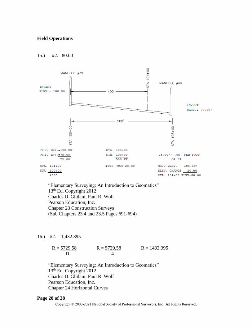
15. Manhole 39 is at station 100+00 and has an invert elevation of 100.00 feet.
Manhole 40 is at station 105+00 and has an invert elevation of 75.00 feet. A 24-
inch reinforced concrete pipe is laid on a straight grade between the two
manholes. At station 104+00, the ground elevation is 90.00 feet. What is the
invert elevation, in feet, of the pipe at this location?
1. 120.00
2. 80.00
3. 100.00
4. 75.00
16. While staking a circular curve for a highway location with a degree of curve of 4º,
the radius of the curve in feet is _____?
1. 4,499.869
2. 1,432.395
3. 5,729.580
4. Can’t solve for the radius without additional information.
17. A drainage ditch runs parallel with the centerline of a highway. The drainage
ditch grade at station 120+00 is -5 percent and the elevation is 1614.00. At
station 127+00 the ditch goes under the centerline of a side road, which requires a
vertical clearance above the top of a 24” culvert. What is the clearance if the side
road elevation is 1584.00 feet?
1. 36”
2. 24”
3. 12”
4. 30”
18. An aerial target is best placed on a ground surface that is:
1. Flat
2. Slightly sloping
3. Clear of all brush
4. In the median of a divided highway

Page 8 of 28
Copyright © 2003-2021 National Society of Professional Surveyors, Inc. All Rights Reserved.
19. What is the calculated offset distance sighting a range pole that is on a 1000-foot
sight if it is discovered that the range pole is 0º 01’ 08” off line?
1. .32’
2. .33’
3. .34’
4. .35’
Field Notes
20. Given the following data for a circular curve on a set of highway plans, knowing
that you need the stationing of the PC before you can calculate the station of the
P.T., what is the stationing of the PC?
PI = 1377+46.0
R = 5729.59
∆ = 16º 45’ LT
T = 843.5
D = 1º 00’
L = 1675.0
1. 1385 + 77.5
2. 1369 + 02.5
3. 1385 + 83.5
4. 1385 + 89.5
21. A route survey of 18.6 miles was made for a new gas transmission line over
rolling brushy terrain. If the open traverse is to conform to second order precision
(class II), what is the maximum allowable error of length in chaining?
1. 9.80 feet
2. 4.91 feet
3. 0.001 mile
4. 3.90 feet
Page 9 of 28
Copyright © 2003-2021 National Society of Professional Surveyors, Inc. All Rights Reserved.
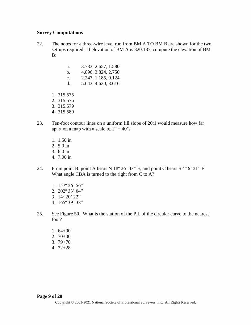
Survey Computations
22. The notes for a three-wire level run from BM A TO BM B are shown for the two
set-ups required. If elevation of BM A is 320.187, compute the elevation of BM
B:
a. 3.733, 2.657, 1.580
b. 4.896, 3.824, 2.750
c. 2.247, 1.185, 0.124
d. 5.643, 4.630, 3.616
1. 315.575
2. 315.576
3. 315.579
4. 315.580
23. Ten-foot contour lines on a uniform fill slope of 20:1 would measure how far
apart on a map with a scale of 1” = 40’?
1. 1.50 in
2. 5.0 in
3. 6.0 in
4. 7.00 in
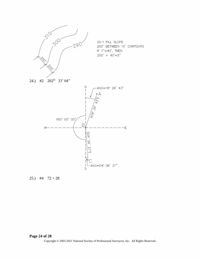
24. From point B, point A bears N 18º 26’ 43” E, and point C bears S 4º 6’ 21” E.
What angle CBA is turned to the right from C to A?
1. 157º 26’ 56”
2. 202º 33’ 04”
3. 14º 20’ 22”
4. 165º 39’ 38”
25. See Figure 50. What is the station of the P.I. of the circular curve to the nearest
foot?
1. 64+00
2. 70+00
3. 79+70
4. 72+28

Page 10 of 28
Copyright © 2003-2021 National Society of Professional Surveyors, Inc. All Rights Reserved.
26. You are staking a fence line starting at station 50+22.1 and going to station
80+38.5. There is an equation at 58+90.6 BK + 60+01.2 AHD. What length of
fence (feet) is needed?
1. 868.5
2. 2037.3
3. 3016.4
4. 2905.8
Plan Reading & Preparation
27. Rectified aerial photographs laid to accurate horizontal control are called a:
1. index mosaic
2. strip controlled mosaic
3. controlled mosaic
4. uncontrolled mosaic
28. FEMA Flood Insurance Rate maps include one of the following:
1. original map creation date
2. last flood profile
3. flood hazard area designation
4. magnetic declination
Page 11 of 28
Copyright © 2003-2021 National Society of Professional Surveyors, Inc. All Rights Reserved.
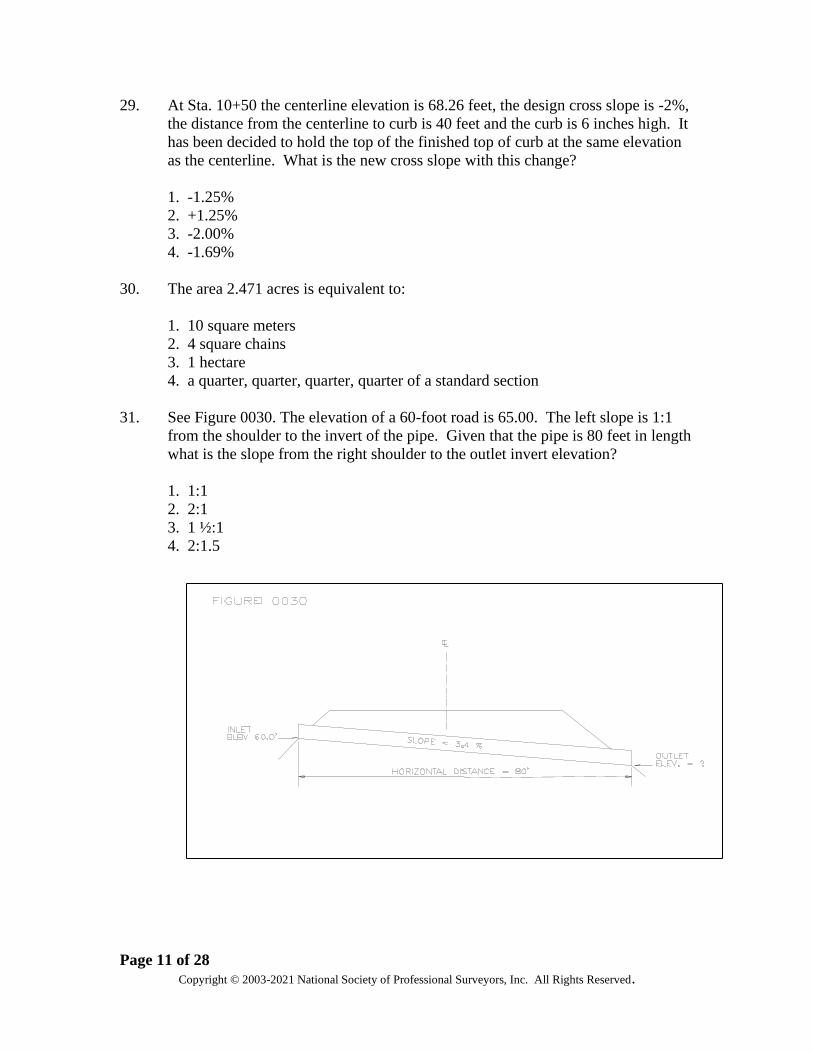
29. At Sta. 10+50 the centerline elevation is 68.26 feet, the design cross slope is -2%,
the distance from the centerline to curb is 40 feet and the curb is 6 inches high. It
has been decided to hold the top of the finished top of curb at the same elevation
as the centerline. What is the new cross slope with this change?
1. -1.25%
2. +1.25%
3. -2.00%
4. -1.69%
30. The area 2.471 acres is equivalent to:
1. 10 square meters
2. 4 square chains
3. 1 hectare
4. a quarter, quarter, quarter, quarter of a standard section
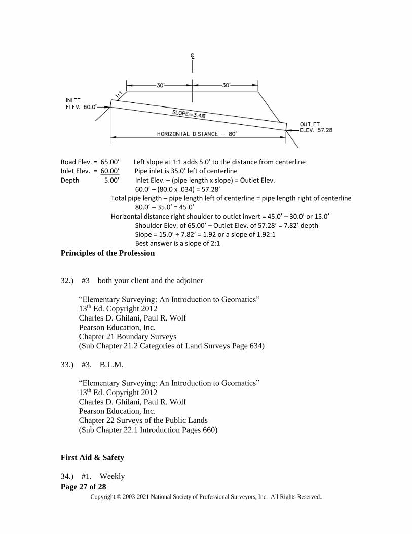
31. See Figure 0030. The elevation of a 60-foot road is 65.00. The left slope is 1:1
from the shoulder to the invert of the pipe. Given that the pipe is 80 feet in length
what is the slope from the right shoulder to the outlet invert elevation?
1. 1:1
2. 2:1
3. 1 ½:1
4. 2:1.5

Page 12 of 28
Copyright © 2003-2021 National Society of Professional Surveyors, Inc. All Rights Reserved.
Principles of the Profession
32. You are performing a boundary survey for a client and discover a conflict
between your client’s property and the adjoining property owner. Your
responsibility is to:
1. the adjoining property owner.
2. your client only.
3. both your client and the adjoiner.
4. the County Surveyor
33. The national organization responsible for surveying of the Public Land Survey
System is the:
1. U.S.F.S.
2. N.S.P.S.
3. B.L.M.
4. U.S.G.S.
First Aid & Safety
34. How often does OSHA require first-aid supplies be checked?
1. weekly
2. daily
3. semi-annually
4. yearly
35. When no infirmary, clinic, hospital, or physician is reasonably close to the job site
and available for the treatment of injured employees, what should be provided as
a minimum?
1. a person who has a valid first-aid card must be on site
2. an EMT must be on site
3. a registered nurse must be on site
4. a paramedic team must be present during work hours.
36. The most serious hazard situation on a construction site is:
1. permitting the site to be dusty on dry days
2. permitting ladders to exceed 20 feet
3. storing fuel in tanks above ground
4. dispensing fuel adjacent to construction field welding

Page 13 of 28
Copyright © 2003-2021 National Society of Professional Surveyors, Inc. All Rights Reserved.
Supervisory Skills
37. It is quitting time and you were told to be careful about any overtime. You have
staked all of the needed corners but one and it will only about an hour to stake the
one remaining corner. What should you do? Considering the crew won’t be able
to return to this project for two weeks and everyone has gone home from the
office.
1. Call the office and ask for guidance
2. Quit work at the regular time
3. Request overtime before proceeding
4. Stake the final corner
38. One of the most critical qualities in a field crew member is?
1. ability to perform calculations
2. ability to work with others
3. extensive experience
4. speed and dexterity
Page 14 of 28
Copyright © 2003-2021 National Society of Professional Surveyors, Inc. All Rights Reserved.
CST LEVEL III SAMPLE TEST ANSWERS
Types of Surveys
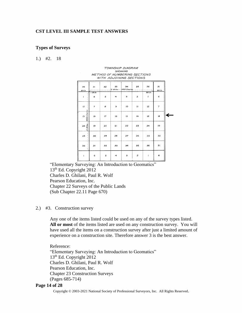
1.) #2. 18
“Elementary Surveying: An Introduction to Geomatics”
13th Ed. Copyright 2012
Charles D. Ghilani, Paul R. Wolf
Pearson Education, Inc.
Chapter 22 Surveys of the Public Lands
(Sub Chapter 22.11 Page 670)
2.) #3. Construction survey
Any one of the items listed could be used on any of the survey types listed.
All or most of the items listed are used on any construction survey. You will
have used all the items on a construction survey after just a limited amount of
experience on a construction site. Therefore answer 3 is the best answer.
Reference:
“Elementary Surveying: An Introduction to Geomatics”
13th Ed. Copyright 2012
Charles D. Ghilani, Paul R. Wolf
Pearson Education, Inc.
Chapter 23 Construction Surveys
(Pages 685-714)

Page 15 of 28
Copyright © 2003-2021 National Society of Professional Surveyors, Inc. All Rights Reserved.
Field Equipment & Instruments
3.) #3. of adjusting a spirit level by splitting the error and adjusting ½ the error until
the bubble does not change position.
“Elementary Surveying: An Introduction to Geomatics”
13th Ed. Copyright 2012
Charles D. Ghilani, Paul R. Wolf
Pearson Education, Inc.
Chapter 4 Leveling – Theory, Methods, and Equipment
(Sub Chapter 4.15.3 Page 97)
4.) #2. 10.55
(a2 – a1) = (5.37 – 3.75) = 1.62 therefore (8.93 + 1.62 = X and X = 10.55
Also see:
“Elementary Surveying: An Introduction to Geomatics”
13th Ed. Copyright 2012
Charles D. Ghilani, Paul R. Wolf
Pearson Education, Inc.
Chapter 4 Leveling – Theory, Methods, and Equipment
(Sub Chapter 4.15.5 Pages 98-100)
5.) #3. the measured distance is less than 100 feet.
“Elementary Surveying: An Introduction to Geomatics”
13th Ed. Copyright 2012
Charles D. Ghilani, Paul R. Wolf
Pearson Education, Inc.
Chapter 6 Distance Measurement
(Sub Chapter 6.24 Pages 160-161)
Page 16 of 28
Copyright © 2003-2021 National Society of Professional Surveyors, Inc. All Rights Reserved.
6.) #3. personal error
“Definitions of Surveying & Associated Terms”
Revised Copyright 2005
American Congress on Surveying and Mapping in collaboration with the University
of Maine
Page 100 error, personal
7.) #4. level
Answers 1, 2, and 3 are used for a horizontal (x,y) location of a specific point. The
level is used for a vertical (z) elevation and is not dependent on a specific point.
Office Operations
8.) #4. 129.78

Page 17 of 28
Copyright © 2003-2021 National Society of Professional Surveyors, Inc. All Rights Reserved.
“Elementary Surveying: An Introduction to Geomatics”
13th Ed. Copyright 2012
Charles D. Ghilani, Paul R. Wolf
Pearson Education, Inc.
Chapter 25 Vertical Curves
(Sub Chapter 25.4 Pages 761)
9.) #2. 21.45
“Elementary Surveying: An Introduction to Geomatics”
13th Ed. Copyright 2012
Charles D. Ghilani, Paul R. Wolf
Pearson Education, Inc.
Chapter 24 Horizontal Curves
(Sub Chapters 24.2 and 24.3 Pages 716-719)
10.) #3. enlarge by 125%
Original scale divided by the desired scale multiplied by 100 = enlargement or
reduction percentage.
75 ÷ 60 = 1.25 x100 = 125%
Page 18 of 28
Copyright © 2003-2021 National Society of Professional Surveyors, Inc. All Rights Reserved.
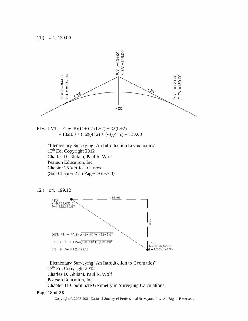
11.) #2. 130.00
Elev. PVT = Elev. PVC + G1(L÷2) +G2(L÷2)
= 132.00 + (+2)(4÷2) + (-3)(4÷2) = 130.00
“Elementary Surveying: An Introduction to Geomatics”
13th Ed. Copyright 2012
Charles D. Ghilani, Paul R. Wolf
Pearson Education, Inc.
Chapter 25 Vertical Curves
(Sub Chapter 25.5 Pages 761-763)
12.) #4. 199.12
“Elementary Surveying: An Introduction to Geomatics”
13th Ed. Copyright 2012
Charles D. Ghilani, Paul R. Wolf
Pearson Education, Inc.
Chapter 11 Coordinate Geometry in Surveying Calculations
Page 19 of 28
Copyright © 2003-2021 National Society of Professional Surveyors, Inc. All Rights Reserved.
(Sub Chapters 11.2 Pages 278-279)
Control Points – Horizontal & Vertical
13.) #1. 0.11 feet
Loop of 4.70 miles = 7.564 kilometers.
Maximum allowable error is 12.0 mm x √ of the approximate horizontal distance
in kilometers.
1 foot = .3048 meters
1 millimeter = 0.0032808 feet and 1 kilometer = 0.6214 miles
4.70 miles = 7.564 km
12mm x √7.5639 km = 33.0 mm
33mm x .003281 = 0.108 feet. or 0.11 feet
“Standards and Specifications for Geodetic Control Networks”
Federal Geodetic Control Committee
Rockville, Maryland
September 1984
Section 3. Specifications
(Sub-section 3.5 Geodetic Leveling Pages 3-6 thru 3-8)
14.) #1. 1:5,000
The NGS standard for 3rd Order, Class II traverse is 1:5,000.
“Standards and Specifications for Geodetic Control Networks”
Federal Geodetic Control Committee
Rockville, Maryland
September 1984
Section 3. Specifications
(Sub-section 3.3 Traverse Pages 3-3 thru 3-5)
Page 20 of 28
Copyright © 2003-2021 National Society of Professional Surveyors, Inc. All Rights Reserved.
Field Operations
15.) #2. 80.00
“Elementary Surveying: An Introduction to Geomatics”
13th Ed. Copyright 2012
Charles D. Ghilani, Paul R. Wolf
Pearson Education, Inc.
Chapter 23 Construction Surveys
(Sub Chapters 23.4 and 23.5 Pages 691-694)
16.) #2. 1,432.395
R = 5729.58 R = 5729.58 R = 1432.395
D 4
“Elementary Surveying: An Introduction to Geomatics”
13th Ed. Copyright 2012
Charles D. Ghilani, Paul R. Wolf
Pearson Education, Inc.
Chapter 24 Horizontal Curves
Page 21 of 28
Copyright © 2003-2021 National Society of Professional Surveyors, Inc. All Rights Reserved.
(Sub Chapters 24.2 and 24.3 Pages 716-719)
17.) #1. 36”
“Elementary Surveying: An Introduction to Geomatics”
13th Ed. Copyright 2012
Charles D. Ghilani, Paul R. Wolf
Pearson Education, Inc.
Chapter 23 Construction Surveys
(Sub Chapter 23.4 Staking Out a Pipeline and 23.5 Staking Pipeline Grades Page
691-694)
18.) #1. Flat
Flat is the BEST answer for aerial target placement. However answers 2, 3, and 4
are not wrong based on guidelines found in the New Jersey Department of
Transportation Minimum Guidelines for Aerial Photogrammetric Mapping,
Section 2-05.3 Targeting Control Points.
19.) #2. .33’

Page 22 of 28
Copyright © 2003-2021 National Society of Professional Surveyors, Inc. All Rights Reserved.
Field Notes
20.) #2. 1369 + 02.5
P.I. Station – Tangent Length = P.C. Station
“Elementary Surveying: An Introduction to Geomatics”
13th Ed. Copyright 2012
Charles D. Ghilani, Paul R. Wolf
Pearson Education, Inc.
Chapter 24 Horizontal Curves
(Sub Chapter 24.4 Circular Curve Stationing Pages 720-721)
21.) #2. 4.91 feet
Smallest permissible closure for a Second Order Class II survey is 1:20,000.
18.6 miles = 98,208.0 feet ÷ 20,000 = 4.9104 feet
___1__ ̳ __X___ X ̳ 98,208 X = 4.91 ft.
20,000 98,208 20,000

Page 23 of 28
Copyright © 2003-2021 National Society of Professional Surveyors, Inc. All Rights Reserved.
“Standards and Specifications for Geodetic Control Networks”
Federal Geodetic Control Committee
Rockville, Maryland
September 1984
Section 3. Specifications
(Sub-section 3.3 Traverse Pages 3-3 thru 3-4)
Survey Computations
22.) #2. 315.576
Sta. Sight Stadia Sight Stadia Elev.
BM A 320.187
3.733 4.896
2.657 3.824 2.6567
1.580 2.750 322.8437
7.970 11.470 -3.8233
2.6567 3.8233
TP1 319.0204
2.247 5.643
1.185 4.630 1.1853
0.124 3.616 320.2057
3.556 13.889 -4.6297
BM B 1.1853 4.6297 315.5760
“Elementary Surveying: An Introduction to Geomatics”
13th Ed. Copyright 2012
Charles D. Ghilani, Paul R. Wolf
Pearson Education, Inc.
Chapter 5 Leveling – Field Procedures and Computations
(Sub Chapter 5.8 Three-Wire Leveling Pages 115-116)
23.) #2. 5.0 in
Page 24 of 28
Copyright © 2003-2021 National Society of Professional Surveyors, Inc. All Rights Reserved.
24.) #2 202O 33’ 04”
25.) #4 72 + 28

Page 25 of 28
Copyright © 2003-2021 National Society of Professional Surveyors, Inc. All Rights Reserved.
T=R(tan I/2) T=2,000(tan 22o 30’) T=2,000( 0.414214) T=828.43
P.C. Sta. + Tangent = P.I. Sta. (Sta. 64+00) + 828.43 = (Sta. 72+28.43)
Or Sta. 72+28
“Elementary Surveying: An Introduction to Geomatics”
13th Ed. Copyright 2012
Charles D. Ghilani, Paul R. Wolf
Pearson Education, Inc.
Chapter 24 Horizontal Curves
(Sub Chapter 24.4 Circular Curve Stationing Page 720-721)
26.) #4 2905.8
Plan Reading & Preparation

Page 26 of 28
Copyright © 2003-2021 National Society of Professional Surveyors, Inc. All Rights Reserved.
27.) #3. controlled mosaic
A mosaic in which the distance and the directions are accurate. A controlled mosaic is
obtained when the photographs are carefully assembled so that horizontal control points
agree with their previous plotted positions. Each aerial photo is corrected for aircraft
height and tilt variations. The central portions of aerial photos are cut out and aligned
with the adjacent aerial photos. Each photo is further oriented by matching features with
survey control points for the area. A controlled mosaic is the basic requirement to permit
accurate targeting.
“The Free Dictionary by Farlex” Online dictionary and encyclopedia.
Web Link: https://www.thefreedictionary.com/controlled+mosaic
28.) #3. flood hazard area designation
From the FEMA website: The Federal Emergency Management Agency (FEMA)
definition for a Flood Insurance Rate Map (FIRM is: The official map of a community
on which FEMA has delineated both the special hazard areas and the risk premium zones
applicable to the community.
29.) #1. -1.25%
30.) #3. 1 hectare
“Definitions of Surveying & Associated Terms”
Revised Copyright 2005
American Congress on Surveying and Mapping in collaboration with the University
of Maine
Page 124 hectare – Approximately 2.471 acres; 10,000 square meters.
31.) #2. 2:1
Page 27 of 28
Copyright © 2003-2021 National Society of Professional Surveyors, Inc. All Rights Reserved.
Road Elev. = 65.00’ Left slope at 1:1 adds 5.0’ to the distance from centerline Inlet Elev. = 60.00’ Pipe inlet is 35.0’ left of centerline Depth 5.00’ Inlet Elev. – (pipe length x slope) = Outlet Elev. 60.0’ – (80.0 x .034) = 57.28’ Total pipe length – pipe length left of centerline = pipe length right of centerline 80.0’ – 35.0’ = 45.0’ Horizontal distance right shoulder to outlet invert = 45.0’ – 30.0’ or 15.0’ Shoulder Elev. of 65.00’ – Outlet Elev. of 57.28’ = 7.82’ depth Slope = 15.0’ ÷ 7.82’ = 1.92 or a slope of 1.92:1 Best answer is a slope of 2:1
Principles of the Profession
32.) #3 both your client and the adjoiner
“Elementary Surveying: An Introduction to Geomatics”
13th Ed. Copyright 2012
Charles D. Ghilani, Paul R. Wolf
Pearson Education, Inc.
Chapter 21 Boundary Surveys
(Sub Chapter 21.2 Categories of Land Surveys Page 634)
33.) #3. B.L.M.
“Elementary Surveying: An Introduction to Geomatics”
13th Ed. Copyright 2012
Charles D. Ghilani, Paul R. Wolf
Pearson Education, Inc.
Chapter 22 Surveys of the Public Lands
(Sub Chapter 22.1 Introduction Pages 660)
First Aid & Safety
34.) #1. Weekly
Page 28 of 28
Copyright © 2003-2021 National Society of Professional Surveyors, Inc. All Rights Reserved.
1926.50(d)(2)
The contents of the first aid kit shall be placed in a weatherproof container with
individual sealed packages for each type of item and shall be checked by the
employer before being sent out on each job and at least weekly on each job to
ensure that the expended items are replaced.
https://www.osha.gov/pls/oshaweb/owadisp.show_document?p_table=STANDAR
DS&p_id=10622
35.) #1. a person who has a valid first-aid card must be on site
Sudden injuries or illnesses, some of which may be life-threatening, occur at
work. The OSHA First Aid standard (29 CFR 1910.151) requires trained first-aid
providers at all workplaces of any size if there is no “infirmary, clinic, or hospital
in near proximity to the workplace which is used for the treatment of all injured
employees.”
https://www.osha.gov/Publications/OSHA3317first-aid.pdf
OSHA Best Practices Guide: Fundamentals of a Workplace First-Aid Program
OSHA Requirements, Page 8.
36.) #4. dispensing fuel adjacent to construction field welding
The most serious hazard is dispensing fuel because of the danger of an explosion
and/or fire.
https://www.osha.gov/pls/oshaweb/owadisp.show_document?p_table=STANDA
RDS&p_id=10698 1926.352(c) No welding, cutting, or heating shall be done
where the application of flammable paints, or the presence of other flammable
compounds, or heavy dust concentrations creates a hazard.
Supervisory Skills
37.) #4. Stake the final corner
Even with the instruction to “be careful about any overtime”, it is best to set the
one remaining corner if it will only take about an hour. The cost of any overtime
pay will likely be more than offset by the travel time to return to the project,
recover your previous control, get your equipment out and set it up. Also, the
client will appreciate not having to wait another two weeks for you to complete
his project.
38.) #2. Ability to work with others

Page 29 of 28
Copyright © 2003-2021 National Society of Professional Surveyors, Inc. All Rights Reserved.
The ability to work with others is the most critical of the answers listed. If the
crew member can work with others they can learn to perform calculations and
gain experience and increase their speed and skills. Teamwork on a survey crew
is extremely important to ensure accuracy, completeness, and overcome obstacles
that get in the way of productivity on a project.