Page 3 Area 3 - Seafish · Please be advised that Scottish Highlands and Islands by BT to perform...
14
1 of 14 Produced by The Kingfisher Information Service of Seafish, in conjunction with Subsea Cables UK and the Crown Estate. Any queries please contact Kingfisher Information Services, Sea Fish Industry Authority, Humber Seafood Institute, Origin Way, Europarc, Grimsby, DN37 9TZ email: [email protected] website: www.kingfishercharts.org tel: +44 (0)1472 252307 fax: +44 (0)1472 268792 14 August 2014 | Issue 17 The shaded blocks below indicate the areas of activity published within this Bulletin. This Bulletin, along with previous issues, can be viewed at: www.kingfishercharts.org Alternatively you can receive the Bulletin via email, by contacting: [email protected] * Unless otherwise stated, all co-ordinates listed in this Bulletin refer to WGS 84 datum Area 5 Pages 8 - 12 Area 4 Page 5 - 7 Area 3 Page 3 - 4 Area 2 - Area 1 Page 2 Area 6 Page 13 - 14
Transcript of Page 3 Area 3 - Seafish · Please be advised that Scottish Highlands and Islands by BT to perform...

1 of 14
Produced by The Kingfisher Information Service of Seafish, in conjunction with Subsea Cables UK and the Crown Estate. Any queries please contact Kingfisher Information Services, Sea Fish Industry Authority, Humber Seafood Institute, Origin Way, Europarc, Grimsby, DN37 9TZ
email: [email protected] website: www.kingfishercharts.org tel: +44 (0)1472 252307 fax: +44 (0)1472 268792
14 August 2014 | Issue 17
The shaded blocks below indicate the areas of activity published within this Bulletin.
This Bulletin, along with previous issues, can be viewed at: www.kingfishercharts.org
Alternatively you can receive the Bulletin via email, by contacting: [email protected]
* Unless otherwise stated, all co-ordinates listed in this Bulletin refer to WGS 84 datum
Area 5
Pages 8 - 12 A
rea 4 Page 5 - 7
Area 3
Page 3 - 4 A
rea 2 -
Area 1 Page 2
Area 6
Page 13 - 14

2 of 14
For ‘live’ Kingfisher updates of all Cable & Wind Farm activities, please visit www.kis-orca.eu
Produced by The Kingfisher Information Service of Seafish, in conjunction with Subsea Cables UK and the Crown Estate. Any queries please contact Kingfisher Information Services, Sea Fish Industry Authority, Humber Seafood Institute, Origin Way, Europarc, Grimsby, DN37 9TZ
email: [email protected] website: www.kingfishercharts.org tel: +44 (0)1472 252307 fax: +44 (0)1472 268792
14 August 2014 | Issue 17
First Published: 17 December 2012 | Latest Update: 17 December 2013
Exposed Cable Sections – SHEFA – 2 Segment 9
The Shefa-2 Segment, running between Manse bay, Orkney and Banff, Scotland has suffered from 3 cable breaks in 2013 all caused by fishing activity. We urgently have to stress that further areas/sections of the SHEFA – 2 Segments 7,8,9 are unburied and therefore exposed. Exposed Cable Sections – SHEFA – 2 Segment 7,8 & 9 Please be advised that there are sections of the SHEFA-2 cable that have been surface laid or remain unburied. These areas represent a hazard to fishing and should be avoided at all times. SHEFA have commissioned an updated Kingfisher Awareness Chart to highlight these areas, which can be downloaded using the link below. For a copy of the Kingfisher Awareness Flyer, showing the exposed sections of SHEFA, please contact the undersigned. Alternatively, click on the link below, or visit www.kingfishercharts.org
Kingfisher Awareness Flyer: SHEFA Exposed Sections (December 2013)
For further information, please contact: Tel: +298243602, Email: [email protected], [email protected]
First Published: 04 June 2014 | Latest Update: 28 July 2014
Scottish Highlands and Islands – Telephonic Cable Linking
Please be advised that Scottish Highlands and Islands by BT to perform the installation of 20 segments of telephonic cable linking the Scottish Islands through 40 beach landings. The project is planned to carry out all operations between 4th June 2014 to 2nd November 2014.
FROM TO VESSEL WORKS TYPE ON Segment
ON Shore-
End LOCATION POSITION
RENE DESCARTES
CABLESHIP'S WORK S1.19 N.A.
Bay of Tuquoy Westray 59°17.405'N 02°57.373'W
Aikerness Orkney
Mainland 59°07.212'N 03°06.014'W
COASTAL CHARRIOT
PLSE SURFACE LAY S1.19
S1.19S Aikerness Orkney Mainland 59°07.212'N 03°06.014'W
S1.19N Bay of Turquoy Westray 59°17.405'N 02°57.373'W
AILSA PLIB BY JETTING
CRAWLER S1.19 S1.19S Aikerness Orkney
Mainland 59°07.212'N 03°06.014'W
S1.19N Bay of Turquoy Westray 59°17.405'N 02°57.373'W
For further information, please contact: Marc Ponselles, Orange Marine, Tel: +33 6 80 17 35 07 email: [email protected]
Area 1

3 of 14
For ‘live’ Kingfisher updates of all Cable & Wind Farm activities, please visit www.kis-orca.eu
Produced by The Kingfisher Information Service of Seafish, in conjunction with Subsea Cables UK and the Crown Estate. Any queries please contact Kingfisher Information Services, Sea Fish Industry Authority, Humber Seafood Institute, Origin Way, Europarc, Grimsby, DN37 9TZ
email: [email protected] website: www.kingfishercharts.org tel: +44 (0)1472 252307 fax: +44 (0)1472 268792
14 August 2014 | Issue 17
First Published: - | Latest Update: -
Hazardous Condition of Cable – Ulysses South Landing – St Margaret’s Bay
Further to earlier Notices, the Ulysses South submarine cable landing at St Margaret's Bay, near Dover, remains broken at a position: 51°08.70'N 01° 24.06'E
This position lies approximately 1.3km offshore in a water depth of 15 metres. As a result of this fault, the cable at the approaches to St Margaret's Bay has been dragged an indeterminate distance to the north of its as laid route on either side of the fault position. Caution should therefore be exercised in this area until the cable repair operation has been carried out.
For further information, please contact: Steven Bennett, Global Marine, Tel: +44 7557 908179 email: [email protected]
First Published: 22 November 2012 | Latest Update: 22 November 2012
Exposed Cable Sections – BritNed Subsea Power Cable
Please be advised that following a recent depth of burial survey, the following sections of the BritNed HVDC Interconnector have been identified as cable exposures:
No. From KP To KP Length (meters)
Coordinates (centre points)
1 166.904 166.899 5 51˚ 49.9192' N 002˚ 52.9871' E 2 163.723 163.718 5 51˚ 50.0508' N 002˚ 50.2647' E 3 163.712 163.698 14 51˚ 50.0508' N 002˚ 50.2647' E 4 157.897 157.891 6 51˚ 49.6704' N 002˚ 45.2981' E 5 131.431 131.422 9 51˚ 51.3849' N 002˚ 24.4973' E 6 132.594 132.589 5 51˚ 51.6382' N 002˚ 25.4193' E 7 91.738 91.73 7 51˚ 40.8860' N 001˚ 54.5844' E 8 90.916 90.913 3 51˚ 40.7143' N 001˚ 53.9298' E 9 90.408 90.397 11 51˚ 40.5892' N 001˚ 53.5320' E
10 73.599 73.585 14 51˚ 35.4597' N 001˚ 41.6457' E 11 52.883 52.806 77 51˚ 29.0055' N 001˚ 27.5754' E 12 53.161 53.207 46 51˚ 29.0379' N 001˚ 27.8646' E
The Kingfisher Awareness Flyer for BritNed is available for download from the link below, or from www.kingfishercharts.org. A new chart highlighting the exposed sections will be produced shortly.
Kingfisher Awareness Flyer: BritNed Subsea Power Cable
For further information, please contact: BritNed Control Room, Tel: +44 (0)1634 273080 or +44 (0)800 0481569
Area 3

4 of 14
For ‘live’ Kingfisher updates of all Cable & Wind Farm activities, please visit www.kis-orca.eu
Produced by The Kingfisher Information Service of Seafish, in conjunction with Subsea Cables UK and the Crown Estate. Any queries please contact Kingfisher Information Services, Sea Fish Industry Authority, Humber Seafood Institute, Origin Way, Europarc, Grimsby, DN37 9TZ
email: [email protected] website: www.kingfishercharts.org tel: +44 (0)1472 252307 fax: +44 (0)1472 268792
14 August 2014 | Issue 17
First Published: 27 February 2013 | Latest Update: 27 February 2013
Fishing Hazard – Vulnerable Subsea Cable, Concerto North
Please be advised that, following two repairs in the same location, an area of vulnerable cable on the Concerto North cable has been identified. Although the repair has been buried the seabed is known to be soft and mobile. Please exercise extreme caution whilst fishing in this area.
For further information, please contact: Neil Donovan at Interoute Communications email: [email protected]
Area 3

5 of 14
For ‘live’ Kingfisher updates of all Cable & Wind Farm activities, please visit www.kis-orca.eu
Produced by The Kingfisher Information Service of Seafish, in conjunction with Subsea Cables UK and the Crown Estate. Any queries please contact Kingfisher Information Services, Sea Fish Industry Authority, Humber Seafood Institute, Origin Way, Europarc, Grimsby, DN37 9TZ
email: [email protected] website: www.kingfishercharts.org tel: +44 (0)1472 252307 fax: +44 (0)1472 268792
14 August 2014 | Issue 17
First Published: 14 August 2014 | Latest Update: 14 August 2014
Survey Operations – Celtic Interconnector Project
On behalf of Intertek please be advised of marine survey operations that are scheduled to commence on or around 9 August 2014 in the offshore waters of the Southwest Approaches and Celtic Sea. Survey vessel Ernest Shackleton has been assigned to carry out initial geophysical surveys along a proposed cable route for the planned Celtic Interconnector power cable between France and Ireland. The survey will take place along the proposed route between the 30 metre water depth contours off France and Ireland. Survey operations are expected to commence in French waters and will proceed in a northerly direction along the proposed route towards Ireland. These survey operations will link into the near shore waters survey of two landfall locations, one off Ballinwilling Strand and one at Ballycroneen Beach near Ballycotton, County Cork. Fishermen are advised not to leave any static fishing equipment within a distance of 250 metres of the proposed survey routes and are respectfully asked to withdraw and keep beyond a distance of at least 1 nautical mile from the survey vessel that will be operating with towed equipment up to 600 metres behind the vessel and will have restricted manoeuvrability. Survey vessel will be working offshore of 30 metre depth contours and will be operating on a 24-hour basis. The vessel will display appropriate day shapes and lights during survey operations and will maintain a listening watch on VHF CH16 and actively transmit an AIS signal (vessel mobile: 0044 1223 2221731). These offshore survey operations are due to be completed in Irish waters on or around 5 September 2014.
For proposed coordinates of the route, please contact the undersigned.
For further information, please contact: Colin Richards, Fishing Liaison – Intertek, Tel: +44 (0) 1404 46323, Mobile: +44 (0) 7702 693 660 E-mail: [email protected]
Area 4

6 of 14
For ‘live’ Kingfisher updates of all Cable & Wind Farm activities, please visit www.kis-orca.eu
Produced by The Kingfisher Information Service of Seafish, in conjunction with Subsea Cables UK and the Crown Estate. Any queries please contact Kingfisher Information Services, Sea Fish Industry Authority, Humber Seafood Institute, Origin Way, Europarc, Grimsby, DN37 9TZ
email: [email protected] website: www.kingfishercharts.org tel: +44 (0)1472 252307 fax: +44 (0)1472 268792
14 August 2014 | Issue 17
First Published: 16 July 2014 | Latest Update: 14 August 2014
Wave Hub Subsea Power Cable Survey – North Coast of Cornwall
Please be advised that the Wave Hub main 33kV cable and hub is to be surveyed as follows between 16th and 30th August 2014 weather permitting. ROV Survey: 50°12.691' N 05°25.639' W to 50°14.222' N 05°29.945' W Multibeam Bathymetry survey: 50°12.691' N 05°25.639' W to 50°20.824' N 05°37.138' W The MBES element of the survey will also include the Hub itself and the four 300m cable tails extending from the Hub – all within the Wave Hub Safety Zone. The Vessel will be at times restricted in her ability to manoeuvre (particularly during the ROV survey) and mariners are requested to give a wide berth (>300m). It is also requested that fishermen please ensure any gear deployed is moved away from the cable corridor prior to commencement of the works. Survey Vessel: Aquadynamic, Call Sign: MERC4 http://www.marinetraffic.com/ais/details/ships/235017555/vessel:AQUADYNAMIC Master: Duncan Milne, Mobile: 07774675072
For further information, please contact: Julius Besterman, Wave Hub, Tel: 01736 800291 email: [email protected]
Area 4

7 of 14
For ‘live’ Kingfisher updates of all Cable & Wind Farm activities, please visit www.kis-orca.eu
Produced by The Kingfisher Information Service of Seafish, in conjunction with Subsea Cables UK and the Crown Estate. Any queries please contact Kingfisher Information Services, Sea Fish Industry Authority, Humber Seafood Institute, Origin Way, Europarc, Grimsby, DN37 9TZ
email: [email protected] website: www.kingfishercharts.org tel: +44 (0)1472 252307 fax: +44 (0)1472 268792
14 August 2014 | Issue 17
First Published: 07 November 2012 | Latest Update: 07 November 2012
Cable Repair – Jersey to Guernsey
Please note that that the HVAC cable between Guernsey & Jersey has recently been repaired. The repaired sections lay between 49°22.736’N 002°29.220’W and 49°22.360’N 002°28.494’W and has a hairpin bight facing west south west extending for 370 meters to 49°22.610’N 002°29.412’W as shown in the image below.
This cable is lying exposed on the sea bed and is at risk of being damaged or causing damage to vessels conducting under water operations such as trawling. Please exercise caution in this area.
For further information, please contact: Heidi Le Noury, Channel Island Electricity Grid, Tel: 44(0)14781 241977, E-Mail: [email protected]
First Published: 22 October 2013 | Latest Update: 04 November 2013
Exposed Cable Section – FLAG Atlantic Subsea Cable
Please be advised that there is a section of the FLAG Atlantic Subsea cable that is unburied. This area represents a hazard to fishing and skippers should exercise caution whilst fishing in the vicinity. The coordinates below highlight the exposed area and the cable splices, which also pose a hazard to fishing.
1. 48°49.407'N 002°35.545'W Start of exposed section 2. 48°49.333'N 002°35.417'W Splice 3. 48°47.988'N 002°35.137'W Splice 4. 48°47.725'N 002°35.088'W Splice 5. 48°47.567'N 002°34.976'W Splice 6. 48°46.878'N 002°35.083'W Splice 7. 48°46.702'N 002°35.077'W Splice 8. 48°46.564'N 002°35.187'W Splice 9. 48°45.380'N 002°35.083'W End of exposed section
For further information, please contact: Marine Managers - Email: [email protected], Tel: +44 7768508940 or Email: [email protected], Tel: +44 7747474819
Area 4

8 of 14
For ‘live’ Kingfisher updates of all Cable & Wind Farm activities, please visit www.kis-orca.eu
Produced by The Kingfisher Information Service of Seafish, in conjunction with Subsea Cables UK and the Crown Estate. Any queries please contact Kingfisher Information Services, Sea Fish Industry Authority, Humber Seafood Institute, Origin Way, Europarc, Grimsby, DN37 9TZ
email: [email protected] website: www.kingfishercharts.org tel: +44 (0)1472 252307 fax: +44 (0)1472 268792
14 August 2014 | Issue 17
First Published: 28 February 2013 | Latest Update: 02 December 2013
Displaced Mattressing – Isle of Man – UK Interconnector Cable
The IOM-UK Interconnector cable runs between Douglas, Isle of Man and Bispham in Blackpool and includes small sections where the interconnector cable is protected by mattresses, three of these sections are as follows: Mattressing co-ordinates:
Route Position: 14.3km 54° 07.68' N 4° 15.36' W to 54° 07.62' N 4° 15.18' W Route Position: 57.3km 53° 57.24' N 3° 40.80' W to 53° 57.12' N 3° 40.50' W Route Position: 71.2km 53° 53.34' N 3° 30.00' W to 53° 53.22' N 3° 29.82' W
Following a recent survey of the above locations it has been identified that a section of mattressing protecting the IOM-UK Interconnector cable, route position 57.3km from the Isle of Man, has been displaced. All fishing vessels are advised to keep clear of the area below:
Route Position: 57.3km: 53° 57.24' N 3° 40.80' W to 53° 57.12' N 3° 40.5' W
Your further co-operation will be greatly appreciated if vessels undertaking ground fishing activities could exercise caution when operating in the vicinity of the mattressed areas identified above. http://www.kis-orca.eu/media/63875/Manx_Cable_IoM_Interconnector_December2013.pdf
For further information, please contact: Stephen McGhee, Manx Electricity Authority, Tel: 07624 498792, email: [email protected]
First Published: 19 December 2013 | Latest Update: 13 June 2014
Fishing Hazard – Exposed Subsea Cable, Beam Trawl and Wire
Please be advised that, following entanglement with a subsea cable, a beam trawl and scallop gear have been discarded at the position below. The fishing gear is entangled with the subsea cable and poses a significant hazard to fishing (L: 10m x H: 2m). There is also over 80m of exposed cable in the vicinity, due to the trawl dragging the cable from its original position. Please exercise extreme caution whilst fishing in this area.
An incident of a fishing vessel snagging his gear on a subsea cable (Hibernia Atlantic) approximately ten nautical miles off the Northern Ireland coast. The position given by the fishing vessel is: 55°22.915’N 06°35.917’W It was advised that the fishermen cut away both sides of his fishing gear and up to 200 fathoms of wire rope. An awareness chart of the area is available from: Steven Bennett, Global Marine, email: [email protected]
For further information, please contact: Alasdair Wilkie, Hibernia Networks, Email: [email protected], Tel: +44 1704 322 306, Mobile: +44 7850 770 577
Area 5

9 of 14
For ‘live’ Kingfisher updates of all Cable & Wind Farm activities, please visit www.kis-orca.eu
Produced by The Kingfisher Information Service of Seafish, in conjunction with Subsea Cables UK and the Crown Estate. Any queries please contact Kingfisher Information Services, Sea Fish Industry Authority, Humber Seafood Institute, Origin Way, Europarc, Grimsby, DN37 9TZ
email: [email protected] website: www.kingfishercharts.org tel: +44 (0)1472 252307 fax: +44 (0)1472 268792
14 August 2014 | Issue 17
First Published: 01 July 2014 | Latest Update: 28 July 2014
Scottish Highlands and Islands – Telephonic Cable Linking
Please be advised that Scottish Highlands and Islands by BT to perform the installation of 20 segments of telephonic cable linking the Scottish Islands through 40 beach landings. The project is planned to carry out all operations between 4th June 2014 to 2nd November 2014.
FROM TO VESSEL WORKS TYPE ON Segment
ON Shore-
End LOCATION POSITION
COASTAL CHARRIOT
PLSE PLGR SURFACE LAY S1.08 S1.08E Glenbar Kintyre 55°35.311'N 05°41.533'W
COASTAL CHARRIOT
PLSE PLGR SURFACE LAY S1.09 S1.09W Craighouse Jura 55°50.299'N 05°56.999'W
RENE DESCARTES
CABLESHIP'S WORK S1.08 N.A.
Lagavulin Islay 55°38.016'N 06°07.882'W
Glenbar Kintyre 55°35.311'N 05°41.533'W
15/08/14 22/08/14 RENE DESCARTES
CABLESHIP'S WORK S1.08 N.A.
Lagavulin Islay 55°38.016'N 06°07.882'W
Glenbar Kintyre 55°35.311'N 05°41.533'W
16/08/14 19/08/14 AILSA PLIB BY JETTING CRAWLER S1.08 S1.08E Glenbar Kintyre 55°35.311'N 05°41.533'W
19/08/14 24/08/14 AILSA PLIB BY JETTING CRAWLER S1.08 S1.08W Lagavulin Islay 55°38.016'N 06°07.882'W
24/08/14 26/08/14 AILSA PLIB BY JETTING CRAWLER S1.09 S1.09W Craighouse Jura 55°50.299'N 05°56.999'W
24/09/14 30/09/14 RENE DESCARTES
CABLESHIP'S WORK S1.09 N.A.
Craighouse Jura 55°50.299'N 05°56.999'W
Ormsary Kintyre 55°53.584'N 05°37.127'W
11/10/14 27/10/14 RENE DESCARTES
CABLESHIP'S WORK S1.06 N.A.
Corrie Arran 55°38.249'N 05°08.311'W
Ardneil Bay Mainland 55°41.774'N 04°53.521'W
For further information, please contact: Marc Ponselles, Orange Marine, Tel: +33 6 80 17 35 07 email: [email protected]
Area 5

10 of 14
For ‘live’ Kingfisher updates of all Cable & Wind Farm activities, please visit www.kis-orca.eu
Produced by The Kingfisher Information Service of Seafish, in conjunction with Subsea Cables UK and the Crown Estate. Any queries please contact Kingfisher Information Services, Sea Fish Industry Authority, Humber Seafood Institute, Origin Way, Europarc, Grimsby, DN37 9TZ
email: [email protected] website: www.kingfishercharts.org tel: +44 (0)1472 252307 fax: +44 (0)1472 268792
14 August 2014 | Issue 17
First Published: 3 July 2014 | Latest Update: 3 July 2014
Hibernia Express – Cable Route Survey (Bristol Channel, South of Ireland, Deep Water)
Please be advised that TE SubCom, on behalf of Hibernia Express, is scheduled to carry out a cable route survey involving multibeam echo-sounder bathymetry, side-scan sonar, magnetometer, sub-bottom profiling and seabed sampling from Brean, Somerset, through the Bristol Channel and westwards towards Ireland and then into deep sea. The survey will start on 1 July 2014 and will last for approximately 25 days, weather permitting. The work will be carried out by the vessel “RV Ridley Thomas” (Callsign: V7JK2). Inshore at Brean, shallow water survey operations will be carried out by RV Wessex Explorer, (Call sign: 2WWE). The vessels will be towing survey equipment up to 200m astern and will be restricted in their ability to manoeuvre whilst carrying out the survey. All project vessels will be listening on VHF Channel 16 throughout the project. All vessels, particularly those engaged in fishing, are requested to give the “RV Ridley Thomas”, and its towed equipment, a wide berth. RV Ridley Thomas and Wessex Explorer will issue Sécurité messages throughout the operational period. Survey route information for the two segments may be seen below:
Segment 1 (Thinned) Segment 2 (Thinned) 1. 51 35.969'N 12 24.099'W 2. 51 33.754'N 11 41.254'W 3. 51 22.063'N 10 33.969'W 4. 51 14.924'N 09 53.500'W 5. 51 12.937'N 09 30.966'W 6. 51 15.051'N 08 47.815'W 7. 51 15.076'N 08 39.126'W 8. 51 15.853'N 08 14.733'W 9. 51 15.701'N 08 13.894'W 10. 51 15.524'N 08 12.997'W 11. 51 16.556'N 07 28.615'W
12. 51 16.352'N 07 27.813'W 13. 51 16.184'N 07 27.151'W 14. 51 17.146'N 06 20.964'W 15. 51 17.245'N 05 29.805'W 16. 51 17.325'N 05 28.963'W 17. 51 17.696'N 05 27.573'W 18. 51 17.800'N 05 26.848'W 19. 51 17.726'N 04 51.111'W 20. 51 17.497'N 04 18.035'W 21. 51 17.234'N 03 53.603'W 22. 51 17.287'N 03 53.089'W
23. 51 17.274'N 03 49.515'W 24. 51 17.177'N 03 46.501'W 25. 51 15.357'N 03 30.313'W 26. 51 15.086'N 03 20.132'W 27. 51 15.603'N 03 15.411'W 28. 51 15.707'N 03 15.025'W 29. 51 15.698'N 03 14.546'W 30. 51 17.182'N 03 00.911'W
1. 51 38.650’N 08 34.850’W 2. 51 36.498’N 08 35.564’W 3. 51 16.940’N 08 39.287’W 4. 51 15.076’N 08 39.290’W
For further information, please contact: Alasdair Wilkie, Hibernia Express, Tel: +44 7958 215474 or, Phil Footman Williams, TE SubCom Tel: +44 7581 581629
First Published: 25 November 2010 | Latest Update: 25 November 2010
Shallow Burial of Submarine Cable Section – Hibernia ‘D’
Following a recent repair to the Hibernia ‘D’ cable, there was difficulty in reburying the cable due to the required depth of 1 metre. Please note the section below which could only be buried to a depth of 30cm, this section also contains the repaired splice. Please exercise caution in this area.
Shallow Buried Section
1. 51°18.893'N 007°50.289'W 2. 51°18.903'N 007°50.229'W 3. 51°18.997'N 007°50.127'W 4. 51°18.998'N 007°50.120'W 5. 51°18.927'N 007°50.011'W 6. 51°18.951'N 007°49.641'W 7. 51°18.974'N 007°49.336'W
For further information, please contact: Steven Bennett, Global Marine, Tel: +44 7557 908179 email: [email protected]
Area 5
11 of 14
For ‘live’ Kingfisher updates of all Cable & Wind Farm activities, please visit www.kis-orca.eu
Produced by The Kingfisher Information Service of Seafish, in conjunction with Subsea Cables UK and the Crown Estate. Any queries please contact Kingfisher Information Services, Sea Fish Industry Authority, Humber Seafood Institute, Origin Way, Europarc, Grimsby, DN37 9TZ
email: [email protected] website: www.kingfishercharts.org tel: +44 (0)1472 252307 fax: +44 (0)1472 268792
14 August 2014 | Issue 17
First Published: - | Latest Update: -
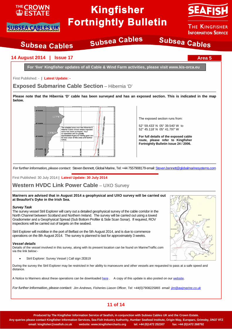
Exposed Submarine Cable Section – Hibernia ‘D’
Please note that the Hibernia ‘D’ cable has been surveyed and has an exposed section. This is indicated in the map below.
The exposed section runs from: 52° 59.433' N 05° 39.540' W to 52° 45.118' N 05° 41.797' W For full details of the exposed cable route, please refer to Kingfisher Fortnightly Bulletin Issue 24 / 2006.
For further information, please contact: Steven Bennett, Global Marine, Tel: +44 7557908179 email: [email protected]
First Published: 30 July 2014 | Latest Update: 30 July 2014
Western HVDC Link Power Cable – UXO Survey
Mariners are advised that in August 2014 a geophysical and UXO survey will be carried out at Beaufort's Dyke in the Irish Sea. Survey Task The survey vessel Stril Explorer will carry out a detailed geophysical survey of the cable corridor in the North Channel between Scotland and Northern Ireland. The survey will be carried out using a towed Gradiometer and a Geophysical Spread (Sub Bottom Profiler & Side Scan Sonar). If required, ROV inspections will be carried out of targets on the seabed. Stril Explorer will mobilise in the port of Belfast on the 5th August 2014, and is due to commence operations on the 8th August 2014. The survey is planned to last for approximately 3 weeks. Vessel details Details of the vessel involved in this survey, along with its present location can be found on MarineTraffic.com via the link below:-
• Stril Explorer: Survey Vessel | Call sign 2EB19
During the survey the Stril Explorer may be restricted in her ability to manoeuvre and other vessels are requested to pass at a safe speed and distance.
A Notice to Mariners about these operations can be downloaded here . A copy of this update is also posted on our website.
For further information, please contact: Jim Andrews, Fisheries Liason Officer, Tel: +44(0)7908225865 email: [email protected]
Area 5

12 of 14
For ‘live’ Kingfisher updates of all Cable & Wind Farm activities, please visit www.kis-orca.eu
Produced by The Kingfisher Information Service of Seafish, in conjunction with Subsea Cables UK and the Crown Estate. Any queries please contact Kingfisher Information Services, Sea Fish Industry Authority, Humber Seafood Institute, Origin Way, Europarc, Grimsby, DN37 9TZ
email: [email protected] website: www.kingfishercharts.org tel: +44 (0)1472 252307 fax: +44 (0)1472 268792
14 August 2014 | Issue 17
First Published: 26 March 2014 | Latest Update: 30 July 2014
Western HVDC Link Power Cable – HDD Landfall, Ardneil & Southannan Sands
Mariners are advised that the proposed installation schedule for the Western HVDC landfall at Ardneil has been slightly adjusted from our original announcement. The large plastic pipes that will house the cables as they make landfall are now expected to arrive on site on 23rd July 2014, and installation of the first pipe is now expected to take place in mid-late August. The second pipe is due to be installed in mid-September. Arrival and storage of pipes The tug Thor Goliath is due to arrive on the 23rd July 2014 towing two long plastic pipes from Norway. These pipes are 620m long and 0.45m in diameter. They will be handed over to a local vessel and anchored south of Hunterston Jetty on the NW edge of Southannan Sands. The NE and SW extremities of the pipes are:-
North East Point: 55°44.967’N 004°52.633’W South West Point: 55°44.617’N 004°53.317’W
The pipes are painted front end and tail and every 50m in between with a 0.5m wide yellow “ribbon” of radar reflecting yellow paint. Installation of Pipes One pipe will be taken to Ardneil Bay for installation in mid-late August while the second pipe will be installed mid September. The pipes will be towed from Hunterston to Ardneil Bay using a local vessel Challenger of Leith and the Jetstar. Prior to the transfer of the pipes from Hunterston a work barge, the LM Constructor will be mobilised to Ardrossan then anchored in Ardneil Bay. The LM Constructor’s tow tug is the Voe Chief. Each pipe will be positioned alongside the LM Constructor prior to being installed into pre-drilled boreholes from Ardneil Bay to an onshore position landwards of West Kilbride Golf Course. The LM Constructor will demobilise to Ardrossan between the two pipe installation times and during periods of bad weather. The pipes will be monitored by a local vessel Challenger of Leith. Vessel details:
• Thor Goliath: Tug: Call Sign: OZ2034 • Challenger of Leith: Tug: Call Sign: 2AAD3 • Jetstar: Tug: Call Sign: MKFU5 • LM Constructor: Work Barge: Call Sign: MHUJ2 • Voe Chief: Tug: Sign: 2CRL5
Vessels will be monitoring VHF Channel 12 throughout the operation. The vessels involved in this work will be restricted in their ability to manoeuvre and other vessels are reminded to navigate with caution in their vicinity and pay strict attention to instructions issued to them by Hunterston Port. Further information please download the links below: http://www.awjmarine.co.uk/fishery-liaison/western-high-voltage-dc-cable/ http://www.awjmarine.co.uk/wp-content/uploads/2014/03/Shallow-Water-Installation-NOTICE-TO-MARINERS-17-03-14.pdf
For further information, please contact: Jim Andrews, Fisheries Liason Officer, Tel: +44(0)7908225865 email: [email protected]
Area 5

13 of 14
For ‘live’ Kingfisher updates of all Cable & Wind Farm activities, please visit www.kis-orca.eu
Produced by The Kingfisher Information Service of Seafish, in conjunction with Subsea Cables UK and the Crown Estate. Any queries please contact Kingfisher Information Services, Sea Fish Industry Authority, Humber Seafood Institute, Origin Way, Europarc, Grimsby, DN37 9TZ
email: [email protected] website: www.kingfishercharts.org tel: +44 (0)1472 252307 fax: +44 (0)1472 268792
14 August 2014 | Issue 17
First Published: 04 June 2014 | Latest Update: 28 July 2014
Scottish Highlands and Islands – Telephonic Cable Linking
Please be advised that Scottish Highlands and Islands by BT to perform the installation of 20 segments of telephonic cable linking the Scottish Islands through 40 beach landings. The project is planned to carry out all operations between 4th June 2014 to 2nd November 2014.
FROM TO VESSEL WORKS TYPE ON Segment
ON Shore-
End LOCATION POSITION
RENE DESCARTES
ROUTE CLEARANCE
PRE LAY GRAPNEL RUNS
S1.16 N.A. Ardvasar Skye 57°03.849'N 05°53.916'W
Mallaigvaig Mallaig 57°00.772'N 05°48.378'W
AILSA PLIB BY JETTING
CRAWLER (beginning of
works) S1.18B N.A. Coilleag Eriskay 57°04.347'N 07°18.261'W
North Bay Barra 57°00.902'N 07°25.866'W
RENE DESCARTES
CABLESHIP'S WORK S1.13 N.A.
Branahuie Bay Stornaway 58°12.297'N 06°18.661'W
Ardmair Ullapool 57°56.032'N 05°11.797'W
COASTAL CHARRIOT
PLSE SURFACE LAY S1.14 S1.14S Lochmaddy North Uist 57°35.851'N 07°09.470'W
AILSA PLIB BY JETTING
CRAWLER (completion of
works) S1.18B N.A. Coilleag Eriskay 57°04.347'N 07°18.261'W
North Bay Barra 57°00.902'N 07°25.866'W
COASTAL
CHARRIOT PLSE PLGR
SURFACE LAY S1.15 S1.15E Dunvegan Skye 57°26.158'N 06°34.848'W
S1.15W Sandwick South Uist 57°23.867'N 07°19.706'W
AILSA PLIB BY JETTING CRAWLER S1.14 S1.14S Lochmaddy North Uist 57°35.851'N 07°09.470'W
AILSA PLIB BY JETTING CRAWLER S1.15 S1.15E Dunvegan Skye 57°26.158’N 06°34.848'W
12/08/14 16/08/14 AILSA PLIB BY JETTING CRAWLER S1.15 S1.15W Sandwick South Uist 57°23.867'N 07°19.706'W
23/08/14 31/08/14 RENE DESCARTES
CABLESHIP'S WORK S1.14 N.A. Leverburgh Harris 57°45.217'N 07°00.182'W
Lochmaddy North Uist 57°35.851'N 07°09.470'W
27/08/14 28/08/14 AILSA PLIB BY JETTING CRAWLER S1.14 S1.14N Leverburgh Harris 57°45.217'N 07°00.182'W
01/09/14 12/09/14 RENE DESCARTES
CABLESHIP'S WORK S1.15 N.A. Dunvegan Skye 57°26.158'N 06°34.848'W
Sandwick South Uist 57°23.867'N 07°19.706'W
12/09/14 19/09/14 RENE DESCARTES
CABLESHIP'S WORK S1.11 N.A. Duart Bay Mull 56°27.089'N 05°40.977'W
Ganavan Bay Oban 56°26.251'N 05°28.167'W
20/09/14 24/09/14 RENE DESCARTES
CABLESHIP'S WORK S1.16 N.A. Ardvasar Skye 57°03.849'N 05°53.916'W
Mallaigvaig Mallaig 57°00.772'N 05°48.378'W
01/10/14 10/10/14 RENE DESCARTES
CABLESHIP'S WORK S1.10 N.A. Tobermory Mull 56°37.278'N 06°04.197'W
Kilchoan Ferry Ardnamurchan 56°41.402'N 06°05.753'W
For further information, please contact: Marc Ponselles, Orange Marine, Tel: +33 6 80 17 35 07 email: [email protected]
Area 6

14 of 14
For ‘live’ Kingfisher updates of all Cable & Wind Farm activities, please visit www.kis-orca.eu
Produced by The Kingfisher Information Service of Seafish, in conjunction with Subsea Cables UK and the Crown Estate. Any queries please contact Kingfisher Information Services, Sea Fish Industry Authority, Humber Seafood Institute, Origin Way, Europarc, Grimsby, DN37 9TZ
email: [email protected] website: www.kingfishercharts.org tel: +44 (0)1472 252307 fax: +44 (0)1472 268792
14 August 2014 | Issue 17
First Published: 26 August 2013 | Latest Update: 15 January 2014
Cable Repairs – TAT 14 (Segment K)
During the last two years there have been several repairs to the TAT 14 segment K cable North of Scotland from the Fair Isle Channel to the Continental Shelf edge and slope. For all details on the current status of the cable please see the up to date Kingfisher Awareness Flyers. These may be obtained by clicking on the links below, or by visiting www.kingfishercharts.org Please note that the following charts have also been updated.
Kingfisher Flyer: Sprint 2013 - ENGLISH
Kingfisher Flyer: Sprint 2013 - FRENCH
Kingfisher Flyer: Sprint 2013 - FAROESE
Kingfisher Flyer: Sprint 2013 - RUSSIAN
For further information, please contact: Barry Peck, Sealine Marine Services, Email: [email protected]
Area 6