Pacific Highway Upgrade Sapphire to Woolgoolga · Pacific Highway Upgrade – Sapphire to...
78
Pacific Highway Upgrade – Sapphire to Woolgoolga Operational Phase Fauna Crossing Monitoring Program ~ Year 1 Sandpiper Ecological PO Box 401 Alstonville, 2477 0401 195 480 [email protected] Version 2 - Final Report 7 February 2017
Transcript of Pacific Highway Upgrade Sapphire to Woolgoolga · Pacific Highway Upgrade – Sapphire to...

Pacific Highway
Upgrade – Sapphire to
Woolgoolga
Operational Phase Fauna
Crossing Monitoring Program ~
Year 1
Sandpiper Ecological
PO Box 401 Alstonville, 2477
0401 195 480
Version 2 - Final Report
7 February 2017

Document Distribution
Date Version Status Sent to Represent Delivered
Format Dispatched By
10/2/2016 A Draft for internal review D. Rohweder SES MS Word B. Taylor
3/3/2016 1 Draft N. Ray RMS MS Word B. Taylor
7/2/2017 2 Final N. Ray RMS Pdf B. Taylor
Project Team: Dr B. Taylor (field survey and reporting)
Mr D. Owner (field survey)
Mr T. Welch (field survey)
Mr N. Priest (field survey)
Mr G. McDonald (field survey)
Dr D. Rohweder (project management and review)
Report prepared for: NSW Roads and Maritime Services
© Sandpiper Ecological Surveys 2017
ABN: 82 084 096 828
PO Box 401
ALSTONVILLE NSW 2477
M 0401 195 480 | E [email protected]
Cover Photo: A sugar glider (Petaurus breviceps) photographed using the Arrawarra Creek glide pole positioned between carriageways.
Disclaimer:
This report has been prepared in accordance with the scope of services described in the contract or agreement between Sandpiper Ecological
Surveys (ABN 82 084 096 828) and Roads and Maritime Services. The report relies upon data, surveys and measurement obtained at the times
and locations specified herein. The report has been prepared solely for use by Roads and Maritime Services and Sandpiper Ecological Surveys
accepts no responsibility for its use by other parties. Sandpiper Ecological Surveys accepts no responsibility or liability for changes in context,
meaning, conclusions or omissions caused by cutting, pasting or editing this report.

Table of Contents
1. Introduction ................................................................................................................................................... 1
1.1 Background .............................................................................................................................................. 1
2. Study Area ..................................................................................................................................................... 2
3. Methods ...................................................................................................................................................... 12
3.1 Underpasses ........................................................................................................................................... 12
3.1.1 Design features .............................................................................................................................. 12
3.1.2 Monitoring fauna using underpasses ............................................................................................. 18
3.1.3 Sampling fauna in adjacent habitat ................................................................................................ 19
3.2 Vegetated median .................................................................................................................................. 22
3.2.1 Design and monitoring methods .................................................................................................... 22
3.2.2 Nest boxes ...................................................................................................................................... 20
3.2.3 Trapping ......................................................................................................................................... 21
3.2.4 Hair funnels .................................................................................................................................... 21
3.2.5 Spotlighting and call playback ........................................................................................................ 21
3.3 Rope bridge and glide pole .................................................................................................................... 22
3.2.2 Rope bridge design features .......................................................................................................... 22
3.2.2 Rope bridge monitoring ................................................................................................................. 22
3.2.2 Glide pole design features .............................................................................................................. 23
3.2.2 Glide pole monitoring .................................................................................................................... 23
3.4 Data Summary and Analysis ................................................................................................................... 24
4. Results ......................................................................................................................................................... 25
4.1 Underpasses and adjacent habitat ........................................................................................................ 25
4.1.1 Species in adjacent habitat ............................................................................................................ 25
4.1.2 Species using underpasses ............................................................................................................. 27
4.1.3 Species in adjacent habitat using underpasses .............................................................................. 29
4.2 Vegetated median .................................................................................................................................. 30
4.2.1 Species Occurrence ........................................................................................................................ 30
4.3 Rope bridge and glide pole .................................................................................................................... 32
4.3.1 Rope bridge and adjacent forest - specied detections ................................................................... 32
4.3.2 Glide poles and adjacent forest - specied detections .................................................................... 33
5. Discussion .................................................................................................................................................... 35
5.1 Project compliance ................................................................................................................................ 35
5.1.1 Monitoring requirements ............................................................................................................... 35
5.1.2 Monitoring aim and performance indicators ................................................................................. 35
5.2 Species use of underpasses ................................................................................................................... 35

5.2.1 Underpass use and comparison with other studies ....................................................................... 35
5.2.2 Difference in use between underpasses ........................................................................................ 37
5.2.3 Use by introduced predators ......................................................................................................... 38
5.2.4 Logistical considerations ................................................................................................................ 38
5.2.5 Performance indicators .................................................................................................................. 38
5.3 Aerial crossing structures and vegetated median.................................................................................. 39
5.3.1 Rope bridge and glide pole detections and crossings .................................................................... 39
5.3.2 Camera performance ..................................................................................................................... 37
5.3.3 Vegetated median detections and crossings ................................................................................. 38
5.3.4 Performance indicators .................................................................................................................. 38
6. Recommendations ....................................................................................................................................... 41
7. References ................................................................................................................................................... 41
Appendix A – Underpass and adjacent habitat data ............................................................................................ 44
Appendix B – Vegetated median data .................................................................................................................. 55
Appendix C – Rope bridge Data ............................................................................................................................ 65
Appendix D – Glide pole Data ............................................................................................................................... 68
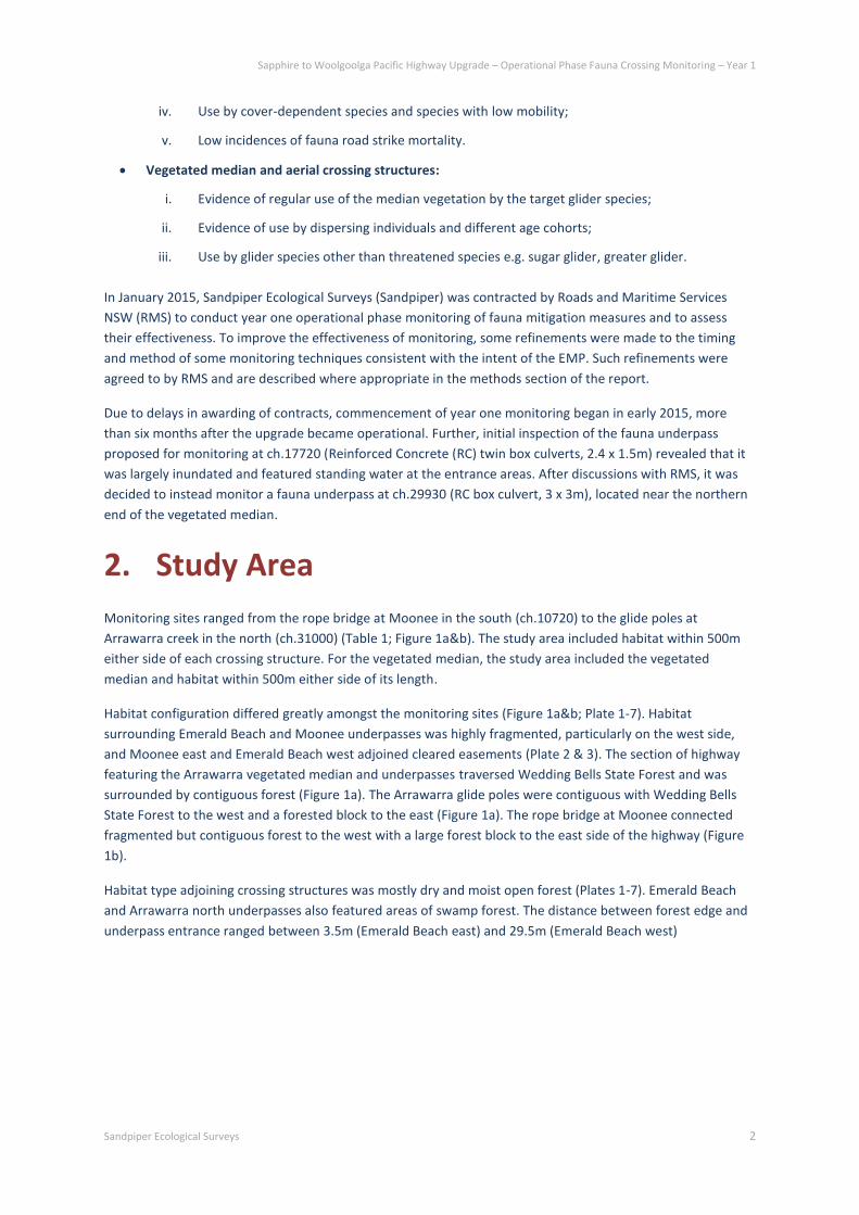
List of Tables
1. Location and habitat features of fauna mitigation structures ............................................................................ 3
2. Design features of fauna underpasses.............................................................................................................. 13
3. Fauna underpass camera monitoring effort ..................................................................................................... 18
4. Adjacent habitat sampling effort. ..................................................................................................................... 19
5. Methods used and survey effort to determine use of the vegetated median by gliders. ................................ 20
6. Installation dates and number of days active for rope bridge and glide pole cameras ................................... 23
7. Fauna recorded at camera bait stations in habitat adjacent to underpasses. ................................................. 26
8. Species detected and number of passes and full crossings of fauna underpasses .......................................... 28
9. Species recorded in adjacent habitat and using underpasses .......................................................................... 30
10. Arboreal mammals recorded within the vegetated median and/or adjacent habitat .................................. 31
11. Photo event records of arboreal mammals on the rope bridge during camera monitoring and arboreal
mammals detected during spotlight surveys in adjacent habitat. ....................................................................... 33
12. Photo event records from Arrawarra glide pole. ............................................................................................ 34
13. Number of fauna and fauna groups recorded in a selection of underpass studies conducted in eastern
Australia.. .............................................................................................................................................................. 37
List of Figures
1a. Map of northern section of study area. ............................................................................................................ 4
1b. Map of southern section of study area. ........................................................................................................... 5
List of Plates
1. Habitat adjoining Moonee rope bridge. ............................................................................................................. 6
2. Habitat adjoining Moonee underpass. ............................................................................................................... 7
3. Habitat adjoining Emerald Beach underpass. ..................................................................................................... 8
4. Habitat adjoining Arrawarra underpass south. .................................................................................................. 9
5. Habitat adjoining Arrawarra underpass north. ................................................................................................. 10
6. Habitat adjoining vegetated median at Arrawarra. .......................................................................................... 11
7. Habitat adjoining Arrawarra creek glide poles.. ............................................................................................... 12
8. Moonee underpass. .......................................................................................................................................... 14
9. Emerald Beach underpass. ............................................................................................................................... 15
10. Arrawarra underpass south ............................................................................................................................ 16
11. Arrawarra underpass north.. .......................................................................................................................... 17
12. Single cell underpasses were monitored each with a Reconyx HC500........................................................... 18
13. Camera bait stations featured a Scoutguard KG680V. ................................................................................... 19
14. Nest box, Elliott trap and hair funnel mounted on a trap tree ....................................................................... 21
15. A Reconyx camera mounted to a sandwich board was positioned at each end of the rope bridge. ............. 22

16. View of the glide pole array at Arrawarra creek.. ........................................................................................... 23
17. Twenty nine vertebrate species were recorded in habitat adjacent to underpasses... ................................. 27
18. The threatened spotted-tail quoll was detected at Moonee east.. ................................................................ 27
19. Seven species were recorded making crossings of the underpasses.. ........................................................... 29
20. Five arboreal mammal species were recorded at the vegetated median site... ............................................ 32
21. Sugar glider and feathertail glider were detected on the Moonee rope bridge... ......................................... 33
22. Sugar glider and feathertail glider were detected on the Arrawarra glide pole... ......................................... 34

Sapphire to Woolgoolga Pacific Highway Upgrade – Operational Phase Fauna Crossing Monitoring – Year 1
Sandpiper Ecological Surveys 1
1. Introduction
The upgrade of the Pacific Highway from Sapphire to Woolgoolga (S2W) involved construction of 25 km of dual
carriageway from Campbell Close, Sapphire, to Arrawarra Beach Road, Arrawarra. The upgrade became
operational in July 2014.
The Ministerial Conditions of Approval (MCoA) for the S2W upgrade included a requirement (MCoA 3.1) to
prepare an Ecological Monitoring Program (EMP) to monitor the effectiveness of mitigation measures
identified in MCoA 2.12(e). The EMP was developed and approved in 2009 and later amended to include data
obtained during the construction phase (BEM 2014). The final version (version 4) was completed in February
2014 (BEM 2014).
The mitigation measures identified in MCoA 2.12(e) include “fauna crossing measures, including vegetated
medians, fauna structures and associated fauna fencing to be installed as part of the project”. The EMP
focuses on nine mitigation measures and specifies sample sites, sample duration and methods. Measures
relevant to the current study include to underpasses at ch.29200, ch.11500, ch.17500 and ch.17720, vegetated
median between ch.29400 and ch.30000, rope bridge at Moonee (ch.10720) and glider poles at Arrawarra
Creek (ch.31020) (BEM 2014). Other measures refer to pre-clearing and clearing procedures, installation of
nest boxes, monitoring of frog pipes, protection of in-situ threatened flora and translocation areas for affected
threatened flora (BEM 2014). The other measures are not the subject of the current report and are reported
on elsewhere.
The following report presents results of year one operational phase monitoring conducted during 2015. The
report includes information on the background, methods, discussion of the results and evaluation of mitigation
measures against the potential indicators of success detailed in the EMP (BEM 2014).
1.1 Background
The EMP identifies several threatened species targeted by the mitigation measures addressed in this report.
These include: common planigale (Planigale maculata), spotted-tail quoll (Dasyurus maculatus), rufous
bettong (Aepyprymnus rufescens), long-nosed potoroo (Potorous tridactylus), brush-tailed phascogale
(Phascogale tapoatafa) and eastern pygmy possum (Cercartetus nanus) use of fauna underpasses; and,
squirrel glider (Petaurus norfolcensis) and yellow-bellied glider (Petaurus australis) use of the vegetated
median, rope bridge and glide poles. Whereas threatened species are the focus of the mitigation measures,
the aim of the EMP is “to allow the effectiveness of mitigation and offset measures to be assessed and allow
for their modification if necessary” (BEM 2014). This includes selection of underpasses that varied somewhat
from those previously monitored, such as pipes, underpasses that cross a vegetated median and a relatively
long dedicated underpass.
The EMP further describes several potential indicators of success with which to assess the performance of
fauna mitigation measures.
Indicators of success include:
Fauna underpasses:
i. Low rates of use of fauna underpasses and adjacent habitats by feral predators;
ii. High levels of fauna underpass use by a wide variety of native fauna species;
iii. Evidence of use by dispersing individuals and different age cohorts;
Sapphire to Woolgoolga Pacific Highway Upgrade – Operational Phase Fauna Crossing Monitoring – Year 1
Sandpiper Ecological Surveys 2
iv. Use by cover-dependent species and species with low mobility;
v. Low incidences of fauna road strike mortality.
Vegetated median and aerial crossing structures:
i. Evidence of regular use of the median vegetation by the target glider species;
ii. Evidence of use by dispersing individuals and different age cohorts;
iii. Use by glider species other than threatened species e.g. sugar glider, greater glider.
In January 2015, Sandpiper Ecological Surveys (Sandpiper) was contracted by Roads and Maritime Services
NSW (RMS) to conduct year one operational phase monitoring of fauna mitigation measures and to assess
their effectiveness. To improve the effectiveness of monitoring, some refinements were made to the timing
and method of some monitoring techniques consistent with the intent of the EMP. Such refinements were
agreed to by RMS and are described where appropriate in the methods section of the report.
Due to delays in awarding of contracts, commencement of year one monitoring began in early 2015, more
than six months after the upgrade became operational. Further, initial inspection of the fauna underpass
proposed for monitoring at ch.17720 (Reinforced Concrete (RC) twin box culverts, 2.4 x 1.5m) revealed that it
was largely inundated and featured standing water at the entrance areas. After discussions with RMS, it was
decided to instead monitor a fauna underpass at ch.29930 (RC box culvert, 3 x 3m), located near the northern
end of the vegetated median.
2. Study Area
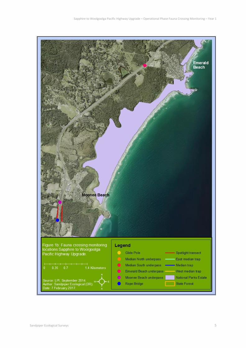
Monitoring sites ranged from the rope bridge at Moonee in the south (ch.10720) to the glide poles at
Arrawarra creek in the north (ch.31000) (Table 1; Figure 1a&b). The study area included habitat within 500m
either side of each crossing structure. For the vegetated median, the study area included the vegetated
median and habitat within 500m either side of its length.
Habitat configuration differed greatly amongst the monitoring sites (Figure 1a&b; Plate 1-7). Habitat
surrounding Emerald Beach and Moonee underpasses was highly fragmented, particularly on the west side,
and Moonee east and Emerald Beach west adjoined cleared easements (Plate 2 & 3). The section of highway
featuring the Arrawarra vegetated median and underpasses traversed Wedding Bells State Forest and was
surrounded by contiguous forest (Figure 1a). The Arrawarra glide poles were contiguous with Wedding Bells
State Forest to the west and a forested block to the east (Figure 1a). The rope bridge at Moonee connected
fragmented but contiguous forest to the west with a large forest block to the east side of the highway (Figure
1b).
Habitat type adjoining crossing structures was mostly dry and moist open forest (Plates 1-7). Emerald Beach
and Arrawarra north underpasses also featured areas of swamp forest. The distance between forest edge and
underpass entrance ranged between 3.5m (Emerald Beach east) and 29.5m (Emerald Beach west)

Sapphire to Woolgoolga Pacific Highway Upgrade – Operational Phase Fauna Crossing Monitoring – Year 1
Sandpiper Ecological Surveys 3
Table 1: Location and habitat features of fauna mitigation structures. SF = swamp forest; MOF = moist open forest; DOF =
dry open forest; Cl = cleared; E = east; W = west
Chainage Location Type Adjoining Habitat
(Distance (m) from structure to adjoining forest)
10720 Moonee Rope bridge E (8.5 to pole): DOF
W (5 to pole): DOF/MOF
11500 Moonee Fauna underpass E (20.5): Cl/MOF/DOF
W (10.5): MOF/DOF
17500 Emerald Beach Fauna underpass E (3.5): SF
W (29.5): Cl/SF
29100-30200 Arrawarra Vegetated median E: SF/MOF/DOF
W: SF/MOF/DOF
29380 Arrawarra south Fauna underpass E (15.8): DOF/MOF
W (28.4): DOF/MOF
29930 Arrawarra north Fauna underpass E (20.8): SF/MOF/DOF
W (17.6): SF/MOF/DOF
31000 Arrawarra creek Glide poles E (23.5): MOF/DOF
W (36): MOF/DOF

Sapphire to Woolgoolga Pacific Highway Upgrade – Operational Phase Fauna Crossing Monitoring – Year 1
Sandpiper Ecological Surveys 4
Sapphire to Woolgoolga Pacific Highway Upgrade – Operational Phase Fauna Crossing Monitoring – Year 1
Sandpiper Ecological Surveys 5

Sapphire to Woolgoolga Pacific Highway Upgrade – Operational Phase Fauna Crossing Monitoring – Year 1
Sandpiper Ecological Surveys 6
Plate 1: Expanse of the 86m-long Moonee rope bridge (ch.10720) looking north (upper). Habitat adjoining rope bridge on
the east (middle) and west (lower) side of the alignment.

Sapphire to Woolgoolga Pacific Highway Upgrade – Operational Phase Fauna Crossing Monitoring – Year 1
Sandpiper Ecological Surveys 7
Plate 2: Habitat adjoining Moonee underpass (ch.11500) on the east (upper) and west (lower) side of the alignment.

Sapphire to Woolgoolga Pacific Highway Upgrade – Operational Phase Fauna Crossing Monitoring – Year 1
Sandpiper Ecological Surveys 8
Plate 3: Habitat adjoining Emerald beach underpass (ch.17500) on the east (upper) and west (lower) side of the alignment.

Sapphire to Woolgoolga Pacific Highway Upgrade – Operational Phase Fauna Crossing Monitoring – Year 1
Sandpiper Ecological Surveys 9
Plate 4: Habitat adjoining Arrawarra underpass south (ch.29380) on the east (upper) and west (lower) side of the
alignment and across the vegetated median (middle).

Sapphire to Woolgoolga Pacific Highway Upgrade – Operational Phase Fauna Crossing Monitoring – Year 1
Sandpiper Ecological Surveys 10
Plate 5: Habitat adjoining Arrawarra underpass north (ch.29930) on the east (upper) and west (lower) side of the alignment
and across the vegetated median (middle).

Sapphire to Woolgoolga Pacific Highway Upgrade – Operational Phase Fauna Crossing Monitoring – Year 1
Sandpiper Ecological Surveys 11
Plate 6: Habitat adjoining Arrawarra vegetated median (ch.29100-30200) on the east/southbound (upper) and
west/northbound (lower) side of the alignment. Adjoining habitat is on the left side of both pictures. (Image: Google
Earth).
Sapphire to Woolgoolga Pacific Highway Upgrade – Operational Phase Fauna Crossing Monitoring – Year 1
Sandpiper Ecological Surveys 12
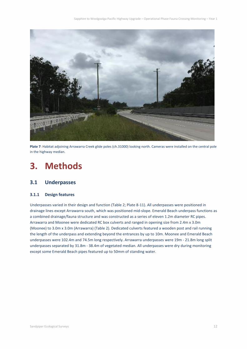
Plate 7: Habitat adjoining Arrawarra Creek glide poles (ch.31000) looking north. Cameras were installed on the central pole
in the highway median.
3. Methods
3.1 Underpasses
3.1.1 Design features
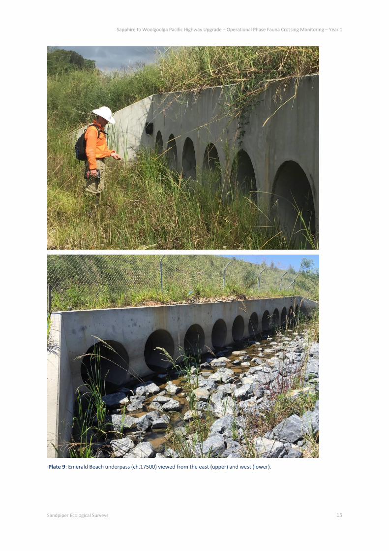
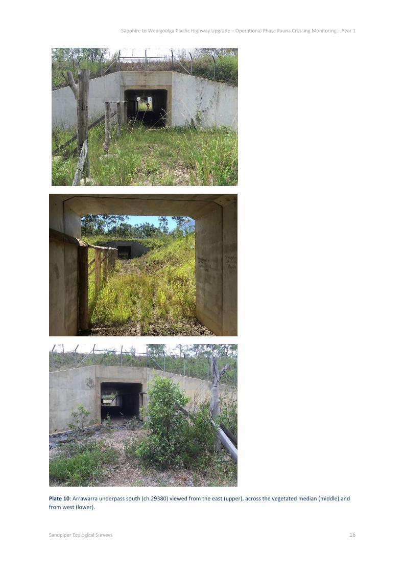
Underpasses varied in their design and function (Table 2; Plate 8-11). All underpasses were positioned in
drainage lines except Arrawarra south, which was positioned mid-slope. Emerald Beach underpass functions as
a combined drainage/fauna structure and was constructed as a series of eleven 1.2m diameter RC pipes.
Arrawarra and Moonee were dedicated RC box culverts and ranged in opening size from 2.4m x 3.0m
(Moonee) to 3.0m x 3.0m (Arrawarra) (Table 2). Dedicated culverts featured a wooden post and rail running
the length of the underpass and extending beyond the entrances by up to 10m. Moonee and Emerald Beach
underpasses were 102.4m and 74.5m long respectively. Arrawarra underpasses were 19m - 21.8m long split
underpasses separated by 31.8m - 38.4m of vegetated median. All underpasses were dry during monitoring
except some Emerald Beach pipes featured up to 50mm of standing water.

Sapphire to Woolgoolga Pacific Highway Upgrade – Operational Phase Fauna Crossing Monitoring – Year 1
Sandpiper Ecological Surveys 13
Table 2: Design features of fauna underpasses. SB = south bound carriageway; NB = northbound carriageway; VM =
vegetated median.
Chainage Location Type Function Length (m) No. & Size
(# x W x H(m))
11500 Moonee RCBC Dedicated 102.4 1 x 3 x 2.4
17500 Emerald Beach RCP Combined 74.5 11 x 1.2 diam.
29380 Arrawarra south RCBC
RCBC
Dedicated 21.4 (NB)
31.8 (VM)
21.4 (SB)
1 x 3 x 3
1 x 3 x 3
29930 Arrawarra north RCBC
RCBC
Dedicated 19 (NB)
38.4 (VM)
21.8 (SB)
1 x 3 x 3
1 x 3 x 3

Sapphire to Woolgoolga Pacific Highway Upgrade – Operational Phase Fauna Crossing Monitoring – Year 1
Sandpiper Ecological Surveys 14
Plate 8: Moonee underpass (ch.11500) viewed from the east (upper) and from the west entrance (lower).
Sapphire to Woolgoolga Pacific Highway Upgrade – Operational Phase Fauna Crossing Monitoring – Year 1
Sandpiper Ecological Surveys 15
Plate 9: Emerald Beach underpass (ch.17500) viewed from the east (upper) and west (lower).
Sapphire to Woolgoolga Pacific Highway Upgrade – Operational Phase Fauna Crossing Monitoring – Year 1
Sandpiper Ecological Surveys 16
Plate 10: Arrawarra underpass south (ch.29380) viewed from the east (upper), across the vegetated median (middle) and
from west (lower).
Sapphire to Woolgoolga Pacific Highway Upgrade – Operational Phase Fauna Crossing Monitoring – Year 1
Sandpiper Ecological Surveys 17
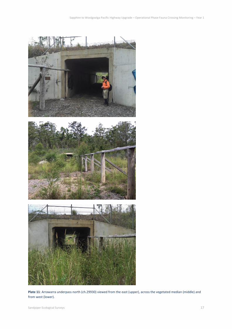
Plate 11: Arrawarra underpass north (ch.29930) viewed from the east (upper), across the vegetated median (middle) and
from west (lower).

Sapphire to Woolgoolga Pacific Highway Upgrade – Operational Phase Fauna Crossing Monitoring – Year 1
Sandpiper Ecological Surveys 18
3.1.2 Monitoring fauna using underpasses
The EMP recommends monitoring of four underpasses and their entrances using sand pads, hair
funnels/tubes, cameras, scat and track searches and artificial ground cover. These methods can be more
effectively covered by using cameras installed in each underpass and a series of cameras and bait stations
installed in adjoining forest. Cameras with bait stations provide a good indication of ground fauna in an area
and are superior in cost and results to hair funnels/tubes, sand pads, scat and track searches and artificial
ground cover (e.g. Paull et al. 2012).
Monitoring was undertaken at the four underpasses using Reconyx HC500 infra-red (IR) cameras. To confirm
complete crossings by fauna, a camera was installed at each end of the single cell underpasses (i.e. Arrawarra
north & south, Moonee). Cameras were mounted to the side wall opposite the wooden rail, ~1.5m above floor
level and ~2m inside the entrance and facing inwards (Plate 12). Cameras were housed in purpose-built
security cases. At the Emerald Beach site, the pipe series is almost 20m across, well beyond the field of view of
a single camera. Monitoring of single pipes was impractical because the site featured 11 pipes. Instead, the
two cameras were used to achieve full coverage of the entire entrance area of one side. As such, two cameras
were positioned at the east side only. Each camera was positioned at either end of the pipe series facing across
the entrance area (Plate 12).
Plate 12: Single cell underpasses were monitored at each end with a Reconyx HC500 camera housed in a security case and
mounted to the side wall opposite the wooden rail (e.g. Moonee underpass, Left). For the pipe series at Emerald Beach, a
camera was mounted on the wing wall at each end of the pipe series and directed across the entrance area of the east side
(Right).
Underpass monitoring occurred over two eight week periods, autumn and spring 2015 (Table 3). Cameras
were set on high sensitivity and to take 5 pictures/activation with no delay between activations. Images were
saved onto an 8GB memory card and batteries and memory cards were checked during the middle of the
monitoring period. All cameras were active/functioning for the full duration of each monitoring period (Table
3).
Table 3: Fauna underpass camera monitoring effort. Days active are for 2 cameras/underpass.
Method Autumn 2015 Spring 2015
Period Days active Period Days active
Moonee 26/3 - 21/5/15 56/56 4/9 - 30/10/15 58/58
Emerald Beach 26/3 - 21/5/15 56/56 4/9 - 30/10/15 58/58
Arrawarra south 26/3 - 21/5/15 56/56 4/9 - 30/10/15 58/58
Arrawarra north 24/3 - 21/5/15 58/58 4/9 - 30/10/15 58/58

Sapphire to Woolgoolga Pacific Highway Upgrade – Operational Phase Fauna Crossing Monitoring – Year 1
Sandpiper Ecological Surveys 19
3.1.3 Sampling fauna in adjacent habitat
Camera bait stations were installed on either side of each underpass to sample fauna in adjoining habitat. Two
bait stations were each positioned at ~450 to and ~50m from each culvert entrance. Each station featured a
Scoutguard KG680V infra-red (IR) camera strapped to a tree or post at ~1m high and focused on a bait
chamber ~2m away (Plate 13). Bait chambers were 150mm long PVC pipe (50mm diameter) capped at both
ends and perforated with numerous holes. One bait chamber was baited with chicken wings and the other
with peanut butter, honey and oats. Fish sauce was drizzled over the chicken bait chambers to serve as an
additional attractant. Bait chambers were anchored to the ground with a tent peg.
Adjacent habitat sampling occurred for four weeks and was conducted during the period of underpass
monitoring. Cameras were set on medium sensitivity and programmed to take 3 pictures/activation. Images
were saved onto 4GB memory cards and retrieved at the end of the four-week period. Due to false triggering
caused largely by moving vegetation, cameras were active for varying number of days during the sampling
period (Table 4). False triggering was most prevalent at the Emerald Beach site. This site is more open and
consequently more vulnerable to vegetation movement caused by wind. One camera was stolen during the
two sampling periods. It was taken from the east side of the Emerald Beach site during autumn sampling.
Plate 13: Camera bait stations featured a Scoutguard KG680V strapped to a tree at ~1m high and focused on a bait
chamber containing either chicken wings (L) or peanut butter, honey and oats (R).
Table 4: Adjacent habitat camera sampling effort. Days active are for 4 cameras/site.
Method Autumn 2015 Spring 2015
Period Days active Period Days active
Moonee 9/4 - 21/5/15 42/41/14/34 4/9 - 29/9/15 26/26/26/26
Emerald Beach 9/4 - 21/5/15 16/42/42/stolen 4/9 - 29/9/15 8/6/9/6
Arrawarra south 10/4 - 21/5/15 16/40/28/41 4/9 - 28/9/15 22/25/25/12
Arrawarra north 10/4 - 21/5/15 36/16/41/41 4/9 - 28/9/15 14/25/23/25
3.2 Vegetated median
3.2.1 Design and monitoring methods
The vegetated median at Arrawarra (ch.29100-30200) was 1100m long and ranged in width between 10-35m
(Plate 6). The vegetation was largely dry open forest with tree heights of up to ~35m. The most prominent
trees were located in the central 600m of the median. Canopy gaps along the carriageways were ~30-60m.

Sapphire to Woolgoolga Pacific Highway Upgrade – Operational Phase Fauna Crossing Monitoring – Year 1
Sandpiper Ecological Surveys 20
Determining whether gliders, particularly the threatened yellow-bellied glider and squirrel glider, use the
vegetated median to cross the highway involved surveys both within the median and within retained habitat
either side of the upgrade corridor. The EMP suggests monitoring through spotlighting, hair funnels and nest
boxes. However, such methods, on their own, would unlikely provide a definitive answer to the question of
road crossing. Therefore, we complemented the above techniques with call playback targeting yellow-bellied
gliders during spotlighting and arboreal trapping targeting squirrel and sugar gliders. The arboreal trapping and
nest box program also utilised a mark-release-recapture approach to detect possible crossings by individual
animals. Further, monitoring was conducted during two eight week periods in summer/autumn and
winter/spring as this better accounts for discrepancies in glider breeding and dispersal activity than a
prolonged period of monitoring in winter/spring as proposed in the EMP. A summary of survey effort and
timing for each method is detailed in Table 5.
Table 5: Methods used and survey effort to determine use of vegetated median by gliders.
Method Summer-Autumn 2015 Winter-Spring 2015 Total
Effort Period Effort Period Effort
Nest boxes 11/2 & 25/3/15 2 checks x 20 boxes 10/8 & 30/9/15 2 checks x 20 boxes 4 checks
Trapping 23-27/3/15 4 nights x 30 traps 28/9 - 2/10/15 4 nights x 30 traps 240 trap-nights
Spotlighting 24 & 26/3/15 2 nights x 3 t’sects 30/9 & 26/10/15 2 nights x 3 t’sects 4 nights
Hair funnels 11/2 - 24/3/15 41 nights x 30 funnels 13/8 - 1/10/15 49 nights x 30 funnels 2700 funnel-nights
3.2.2 Nest boxes
At the beginning of the summer/autumn monitoring period, two 500m-long transects were established in
habitat immediately to the east and west of the vegetated median (Figure 1; Plate 6). Each transect ran parallel
to the highway and meandered ~5-40m from the forest edge. Transects were used for nest box installation,
trapping, hair funnels and spotlighting. A third 500m-long transect was also established in the median for
installation of traps, hair funnels and spotlighting.
Ten nest boxes targeting squirrel/sugar gliders (rear-entry, plywood box manufactured by Hollow Logs Homes)
were each installed on the east and west transects. No boxes were installed in the vegetated median because,
as stated in the EMP, “the purpose of the vegetated median and glider crossing structures will be to maintain
habitat connectivity for glider species known to occur in the locality in order to maintain genetic variation and
to provide opportunity for dispersal and recolonization” (BEM 2014). Installing nest boxes within the median
could encourage resident animals to establish home territories within the median and thus act as a possible
deterrent to use by non-resident or dispersing individuals. Boxes were installed at a height of 8m on mature
rough-barked trees using a ladder (Plate 14). Boxes were spaced at 50m intervals along each transect. Boxes
were installed at the beginning of the summer/autumn monitoring period and inspected at the end of the 8-
week period. Boxes were then inspected at both the beginning and end of the 8-week winter/spring period
(Table 5).
The contents of nest boxes were inspected by two personnel utilising a purpose-built GoPro camera mounted
on an extendable pole. Images from the GoPro camera were wirelessly streamed to an iPad for viewing. Fauna
present, signs of use and box condition were recorded for each box. If a box contained gliders, a ladder was
used to access the box and remove the individuals. Captured gliders were weighed, sexed and breeding status
determined. Each individual was then issued a numbered ear tag and returned to the box.
Sapphire to Woolgoolga Pacific Highway Upgrade – Operational Phase Fauna Crossing Monitoring – Year 1
Sandpiper Ecological Surveys 21
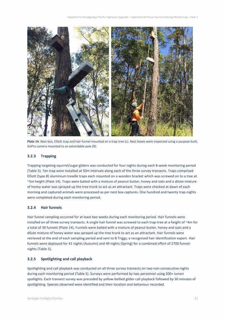
Plate 14: Nest box, Elliott trap and hair funnel mounted on a trap-tree (L). Nest boxes were inspected using a purpose built,
GoPro camera mounted to an extendable pole (R).
3.2.3 Trapping
Trapping targeting squirrel/sugar gliders was conducted for four nights during each 8-week monitoring period
(Table 5). Ten trap were installed at 50m intervals along each of the three survey transects. Traps comprised
Elliott (type B) aluminium treadle traps each mounted on a wooden bracket which was screwed on to a tree at
~5m height (Plate 14). Traps were baited with a mixture of peanut butter, honey and oats and a dilute mixture
of honey water was sprayed up the tree trunk to act as an attractant. Traps were checked at dawn of each
morning and captured animals were processed as per nest box captures. One hundred and twenty trap-nights
were completed during each monitoring period.
3.2.4 Hair funnels
Hair funnel sampling occurred for at least two weeks during each monitoring period. Hair funnels were
installed on all three survey transects. A single hair funnel was screwed to each trap-tree at a height of ~4m for
a total of 30 funnels (Plate 14). Funnels were baited with a mixture of peanut butter, honey and oats and a
dilute mixture of honey water was sprayed up the tree trunk to act as an attractant. Hair funnels were
retrieved at the end of each sampling period and sent to B.Triggs, a recognised hair identification expert. Hair
funnels were deployed for 41 nights (Autumn) and 49 nights (Spring) for a combined effort of 2700 funnel-
nights (Table 5).
3.2.5 Spotlighting and call playback
Spotlighting and call playback was conducted on all three survey transects on two non-consecutive nights
during each monitoring period (Table 5). Surveys were performed by two personnel using 200+ lumen
spotlights. Each transect survey was preceded by yellow-bellied glider call playback followed by 30 minutes of
spotlighting. Species observed were identified and their location and behaviour recorded.
Sapphire to Woolgoolga Pacific Highway Upgrade – Operational Phase Fauna Crossing Monitoring – Year 1
Sandpiper Ecological Surveys 22
3.3 Rope bridge and glide pole
3.3.1 Rope bridge - design features
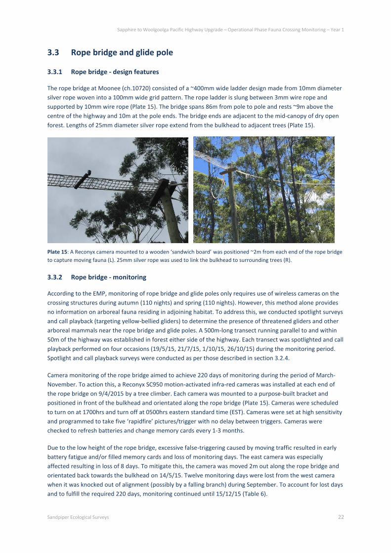
The rope bridge at Moonee (ch.10720) consisted of a ~400mm wide ladder design made from 10mm diameter
silver rope woven into a 100mm wide grid pattern. The rope ladder is slung between 3mm wire rope and
supported by 10mm wire rope (Plate 15). The bridge spans 86m from pole to pole and rests ~9m above the
centre of the highway and 10m at the pole ends. The bridge ends are adjacent to the mid-canopy of dry open
forest. Lengths of 25mm diameter silver rope extend from the bulkhead to adjacent trees (Plate 15).
Plate 15: A Reconyx camera mounted to a wooden ‘sandwich board’ was positioned ~2m from each end of the rope bridge
to capture moving fauna (L). 25mm silver rope was used to link the bulkhead to surrounding trees (R).
3.3.2 Rope bridge - monitoring
According to the EMP, monitoring of rope bridge and glide poles only requires use of wireless cameras on the
crossing structures during autumn (110 nights) and spring (110 nights). However, this method alone provides
no information on arboreal fauna residing in adjoining habitat. To address this, we conducted spotlight surveys
and call playback (targeting yellow-bellied gliders) to determine the presence of threatened gliders and other
arboreal mammals near the rope bridge and glide poles. A 500m-long transect running parallel to and within
50m of the highway was established in forest either side of the highway. Each transect was spotlighted and call
playback performed on four occasions (19/5/15, 21/7/15, 1/10/15, 26/10/15) during the monitoring period.
Spotlight and call playback surveys were conducted as per those described in section 3.2.4.
Camera monitoring of the rope bridge aimed to achieve 220 days of monitoring during the period of March-
November. To action this, a Reconyx SC950 motion-activated infra-red cameras was installed at each end of
the rope bridge on 9/4/2015 by a tree climber. Each camera was mounted to a purpose-built bracket and
positioned in front of the bulkhead and orientated along the rope bridge (Plate 15). Cameras were scheduled
to turn on at 1700hrs and turn off at 0500hrs eastern standard time (EST). Cameras were set at high sensitivity
and programmed to take five ‘rapidfire’ pictures/trigger with no delay between triggers. Cameras were
checked to refresh batteries and change memory cards every 1-3 months.
Due to the low height of the rope bridge, excessive false-triggering caused by moving traffic resulted in early
battery fatigue and/or filled memory cards and loss of monitoring days. The east camera was especially
affected resulting in loss of 8 days. To mitigate this, the camera was moved 2m out along the rope bridge and
orientated back towards the bulkhead on 14/5/15. Twelve monitoring days were lost from the west camera
when it was knocked out of alignment (possibly by a falling branch) during September. To account for lost days
and to fulfill the required 220 days, monitoring continued until 15/12/15 (Table 6).
Sapphire to Woolgoolga Pacific Highway Upgrade – Operational Phase Fauna Crossing Monitoring – Year 1
Sandpiper Ecological Surveys 23
Table 6: Installation dates and number of days active for cameras installed on the rope bridge at Moonee and glide pole at
Arrawarra Creek.
Structure Camera position Install date Final check Days active
Rope Bridge East 9/4/15 15/12/15 242
West 9/4/15 15/12/15 238
Glide pole East 9/4/15 15/12/15 231
North 9/4/15 15/12/15 250
3.3.3 Glide pole - design features
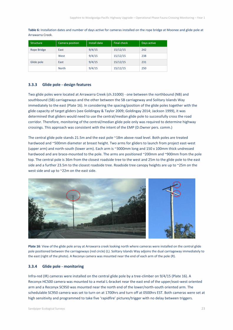
Two glide poles were located at Arrawarra Creek (ch.31000) - one between the northbound (NB) and
southbound (SB) carriageways and the other between the SB carriageway and Solitary Islands Way
immediately to the east (Plate 16). In considering the spacing/position of the glide poles together with the
glide capacity of target gliders (see Goldingay & Taylor 2009; Goldingay 2014; Jackson 1999), it was
determined that gliders would need to use the central/median glide pole to successfully cross the road
corridor. Therefore, monitoring of the central/median glide pole only was required to determine highway
crossings. This approach was consistent with the intent of the EMP (D.Owner pers. comm.)
The central glide pole stands 21.5m and the east pole ~18m above road level. Both poles are treated
hardwood and ~500mm diameter at breast height. Two arms for gliders to launch from project east-west
(upper arm) and north-south (lower arm). Each arm is ~3000mm long and 150 x 100mm thick undressed
hardwood and are brace-mounted to the pole. The arms are positioned ~200mm and ~900mm from the pole
top. The central pole is 36m from the closest roadside tree to the west and 25m to the glide pole to the east
side and a further 23.5m to the closest roadside tree. Roadside tree canopy heights are up to ~25m on the
west side and up to ~22m on the east side.
Plate 16: View of the glide pole array at Arrawarra creek looking north where cameras were installed on the central glide
pole positioned between the carriageways (red circle) (L). Solitary Islands Way adjoins the dual carriageway immediately to
the east (right of the photo). A Reconyx camera was mounted near the end of each arm of the pole (R).
3.3.4 Glide pole - monitoring
Infra-red (IR) cameras were installed on the central glide pole by a tree-climber on 9/4/15 (Plate 16). A
Reconyx HC500 camera was mounted to a metal L-bracket near the east end of the upper/east-west oriented
arm and a Reconyx SC950 was mounted near the north end of the lower/north-south oriented arm. The
schedulable SC950 camera was set to turn on at 1700hrs and turn off at 0500hrs EST. Both cameras were set at
high sensitivity and programmed to take five ‘rapidfire’ pictures/trigger with no delay between triggers.
Sapphire to Woolgoolga Pacific Highway Upgrade – Operational Phase Fauna Crossing Monitoring – Year 1
Sandpiper Ecological Surveys 24
Cameras were checked to refresh batteries and change memory cards every 1-3 months. Early battery fatigue
occurred on one occasion in the east camera resulting in loss of ~19 monitoring days during the monitoring
period. To account for lost days and to fulfill the required 220 days, monitoring continued until 15/12/15
(Table 6).
Spotlight surveys and call playback was conducted in forest habitat adjacent to the glide poles to determine
the presence of threatened gliders and other arboreal mammals. A 500m-long transect running parallel to and
within 50m of the highway was established in forest either side of the highway. Each transect was spotlighted
and call playback performed on four occasions (19/5/15, 21/7/15, 1/10/15, 26/10/15) during the monitoring
period. Spotlight and call playback surveys were conducted as per those described in section 3.2.3.
3.4 Data Summary and Analysis
All images were uploaded to a computer and viewed using Windows Photo Viewer. Senior staff reviewed all
images, with reference to standard field guides (i.e. Menkhorst & Knight 2003; Pizzey & Knight 2007). Data
recorded included: site, date, time, species, accuracy (definite (90%+ certainty), probable (75-90% certainty),
possible (60-75% certainty)), movement direction (east or west), number of images and image numbers. For
rope bridge pictures the portion of rope bridge used (i.e. edge, center) and for the glide pole which part of the
pole/arm used was also recorded. A hierarchical approach was adopted to species identification that included:
species, genus or group.
Passes (underpasses, rope bridge) or events (glide pole) were defined as a photo sequence separated by at
least 10 minutes or when individuals in consecutive sequences were clearly distinguishable. Pass totals for
each structure was summed for the two cameras for each season. Full crossing of an underpass or rope bridge
was scored when an individual was recorded moving away from one camera and then photographed less than
10 minutes later by the opposite camera exiting the structure, or when an animal was recorded making
directional movement by one camera and was not recorded again by the same camera within a period of 10
minutes (see Cramer 2013; Goldingay et al. 2013; Soanes et al. 2015). In the latter scenario, a crossing is
inferred based on direction of movement. The absence of photographs at the other end of the structure is
presumed to be an instance of detection evasion. This approach distinguishes crossings from ‘visits’ whereby
an individual is observed turning around or returning in <10 minutes or does not demonstrate clear directional
movement (e.g. exploratory movements). A full crossing of the Emerald Beach pipe series, which feature
cameras on one side of the underpass only, was scored when an individual demonstrated directional
movement either into or out of the pipes.
Road crossings via the glide pole could not be confirmed because direction of travel to and from the glide pole
cannot be determined. While we acknowledge that an individual may glide to the central pole and return to
the same side, we expect this to represent a very small proportion of detections. There is no habitat in the
center of the carriageways and, therefore, no apparent reason for gliders to repeatedly access the glide pole
without completing a crossing. This is consistent with analyses of glide pole monitoring records from the Hume
Highway which was supported by radio-tracking data (see Soanes et al. 2015). Therefore, a photo sequence of
an individual glider on the glide pole was scored as a road crossing though we acknowledge that the total
figure may be an overestimate.

Sapphire to Woolgoolga Pacific Highway Upgrade – Operational Phase Fauna Crossing Monitoring – Year 1
Sandpiper Ecological Surveys 25
4. Results
4.1 Underpasses and adjacent habitat
4.1.1 Species in adjacent habitat
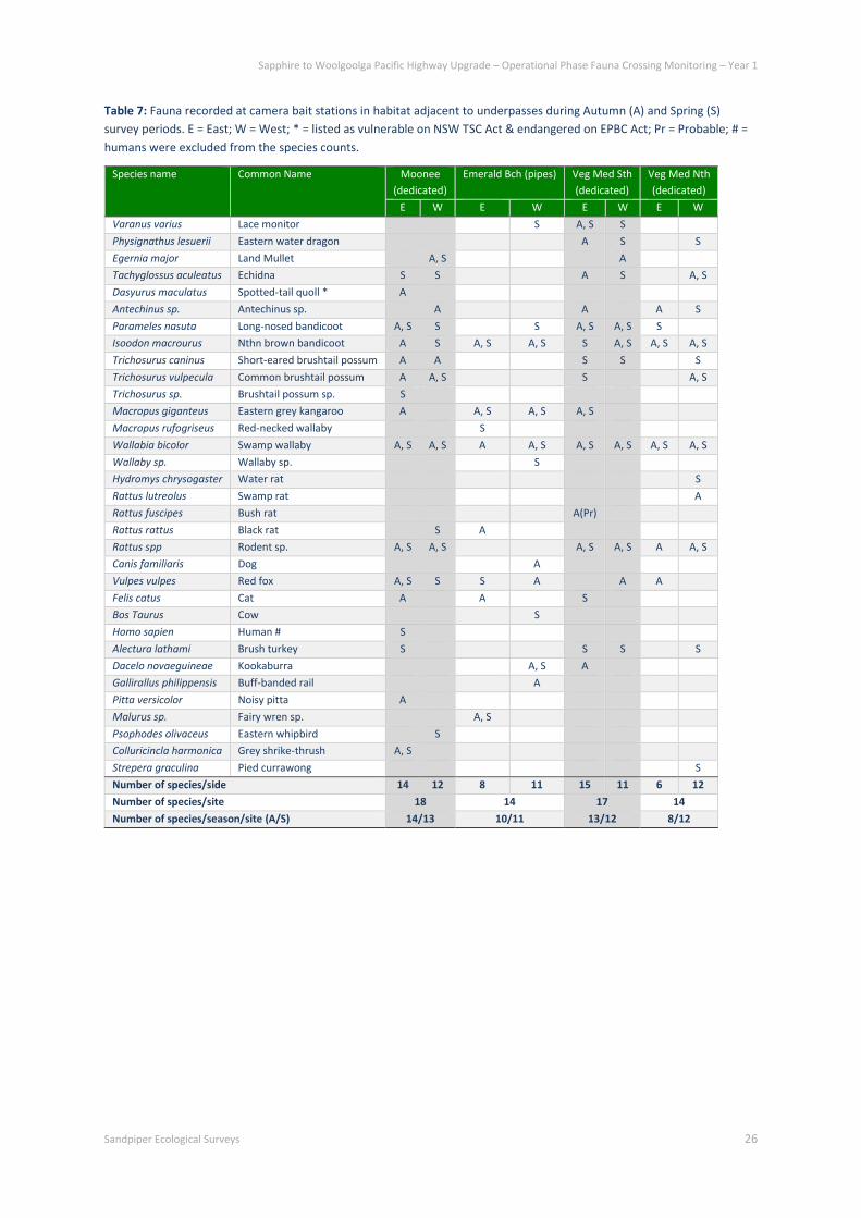
Thirty-nine species/groups of vertebrate fauna were detected by cameras in habitat adjacent to underpasses
(Table 7; Plate 17). Moonee was the most diverse site (18 species) and Emerald Beach and vegetated median
north the least (14 species). All sites recorded a similar number of species on each side of the underpass
except the east side of vegetated median north site was half as diverse as the west side (6 versus 12). An
equivalent number of species were recorded in each season except markedly fewer species were recorded in
autumn at the vegetated median north site. Northern brown bandicoot (Isoodon macrourus), long-nosed
bandicoot (Perameles nasuta), swamp wallaby (Wallabia bicolor) and red fox (Vulpes vulpes) were the most
commonly detected species and were recorded at all sites.
One threatened species - a spotted-tail quoll (Dasyurus maculatus maculatus) - was recorded on one occasion
during autumn on the east side of Moonee underpass (Plate 18). Spotted-tail quoll is listed as vulnerable by
the NSW Threatened Species Conservation (TSC) Act 1995 and endangered under the Commonwealth
Environment Protection and Biodiversity Conservation (EPBC) Act 1999.
Full details of adjacent habitat camera monitoring effort are provided in Table A1 and A2 (Appendix A).
Sapphire to Woolgoolga Pacific Highway Upgrade – Operational Phase Fauna Crossing Monitoring – Year 1
Sandpiper Ecological Surveys 26
Table 7: Fauna recorded at camera bait stations in habitat adjacent to underpasses during Autumn (A) and Spring (S)
survey periods. E = East; W = West; * = listed as vulnerable on NSW TSC Act & endangered on EPBC Act; Pr = Probable; # =
humans were excluded from the species counts.
Species name
Common Name Moonee
(dedicated)
Emerald Bch (pipes) Veg Med Sth
(dedicated)
Veg Med Nth
(dedicated)
E W E W E W E W
Varanus varius Lace monitor S A, S S
Physignathus lesuerii Eastern water dragon A S S
Egernia major Land Mullet A, S A
Tachyglossus aculeatus Echidna S S A S A, S
Dasyurus maculatus Spotted-tail quoll * A
Antechinus sp. Antechinus sp. A A A S
Parameles nasuta Long-nosed bandicoot A, S S S A, S A, S S
Isoodon macrourus Nthn brown bandicoot A S A, S A, S S A, S A, S A, S
Trichosurus caninus Short-eared brushtail possum A A S S S
Trichosurus vulpecula Common brushtail possum A A, S S A, S
Trichosurus sp. Brushtail possum sp. S
Macropus giganteus Eastern grey kangaroo A A, S A, S A, S
Macropus rufogriseus Red-necked wallaby S
Wallabia bicolor Swamp wallaby A, S A, S A A, S A, S A, S A, S A, S
Wallaby sp. Wallaby sp. S
Hydromys chrysogaster Water rat S
Rattus lutreolus Swamp rat A
Rattus fuscipes Bush rat A(Pr)
Rattus rattus Black rat S A
Rattus spp Rodent sp. A, S A, S A, S A, S A A, S
Canis familiaris Dog A
Vulpes vulpes Red fox A, S S S A A A
Felis catus Cat A A S
Bos Taurus Cow S
Homo sapien Human # S
Alectura lathami Brush turkey S S S S
Dacelo novaeguineae Kookaburra A, S A
Gallirallus philippensis Buff-banded rail A
Pitta versicolor Noisy pitta A
Malurus sp. Fairy wren sp. A, S
Psophodes olivaceus Eastern whipbird S
Colluricincla harmonica Grey shrike-thrush A, S
Strepera graculina Pied currawong S
Number of species/side 14 12 8 11 15 11 6 12
Number of species/site 18 14 17 14
Number of species/season/site (A/S) 14/13 10/11 13/12 8/12

Sapphire to Woolgoolga Pacific Highway Upgrade – Operational Phase Fauna Crossing Monitoring – Year 1
Sandpiper Ecological Surveys 27
Plate 17: Twenty-nine vertebrate species were recorded in habitat adjoining fauna underpasses, including common
brushtail possum (top L), echidna (top M), lace monitor (top R), long-nosed bandicoot (bottom L), swamp wallaby (bottom
M) and eastern grey kangaroo (bottom R).
Plate 18: The threatened spotted-tail quoll (L & R) was detected on one occasion in habitat to the east of the Moonee
underpass.
4.1.2 Species using underpasses
Seven fauna species were confirmed using at least one of the four fauna underpasses during autumn and
spring monitoring (Table 8; Plate 19). Echidna is not included as it was only recorded on one occasion exploring
the outside of the Emerald Beach pipe series and did not demonstrate directional movement in or out of a
pipe (i.e. visit). One hundred and twenty-seven passes and 89 full crossings were recorded by the eight
cameras. More passes and crossings were recorded in spring than autumn (95 and 69 versus 32 and 20)
although this was largely attributed to high use of Moonee underpass by red fox during spring. Moonee was
the most frequented underpass with 84 passes and 63 full crossings although this is similarly attributed to high
use by red fox. Vegetated median north and south were underpasses most frequented by native fauna (14
passes each) and Moonee and Emerald the least frequented (6 and 7 passes respectively). Vegetated median
north featured the greatest diversity of native species users, including lace monitor (Varanus varius), eastern
grey kangaroo (Macropus giganteus), red-necked wallaby (Macropus rufogriseus) and swamp wallaby. Emerald
Beach also recorded four native species around the entrance area but only northern brown bandicoot was
recorded crossing based on directional movement toward the pipe opening (Plate 19).

Sapphire to Woolgoolga Pacific Highway Upgrade – Operational Phase Fauna Crossing Monitoring – Year 1
Sandpiper Ecological Surveys 28
Six mammal species were recorded using the four underpasses (Table 8). Eastern grey kangaroo made passes
of cameras at all underpasses yet was only recorded making full crossings at vegetated median north. Swamp
wallaby was the most prolific native species user, registering the most passes and crossings (26/20) and was
recorded at all underpasses except Emerald Beach (Plate 19). Northern brown bandicoot was recorded making
a crossing through a pipe at Emerald Beach based on strong directional movement (Plate 19). Two introduced
mammal species, red fox and dog (Canis familiaris), were recorded at Moonee and Emerald Beach (fox only)
underpasses. Red fox frequently made full crossings of the Moonee underpass and was photographed with
prey in its mouth on four occasions (Plate 19). Lace monitor was the only reptile species recorded. It made
passes at three of the four underpasses, including full crossings at Moonee and vegetated median north (Plate
19).
Full details of underpass camera monitoring effort and detections are provided in Table A1 and A3 (Appendix
A).
Table 8: Species detected and number of passes and full crossings (passes/crossings) recorded by cameras at each end of
fauna underpasses. A = Autumn; S = Spring. # = humans and motorbikes are not included in Passes/Crossings Totals.
Species name Common Name Moonee Emerald Bch Veg Med sth Veg Med nth Total
pass/cross A S A S A S A S
Varanus varius Lace monitor 1/1 1/0 3/3 5/4
Tachyglossus aculeatus Echidna 1/0 1/0
Isoodon macrourus Ntnn br bandicoot 1/1 1/1
Macropus giganteus Estn grey kangaroo 1/0 1/0 3/0 1/0 1/1 7/1
Macropus rufogriseus Red-necked wallaby 1/1 1/1
Wallabia bicolor Swamp wallaby 1/0 3/2 4/3 9/7 7/6 2/2 26/20
Canis familiaris Dog 2/1 2/1
Vulpes vulpes Red fox 12/9 64/50 5/1 3/1 84/61
Homo sapien Human 5/2 2/0 2/1 9/3
Motorbike 4/2 4/2 2/1 10/5
Total Fauna Passes/Crossings # 13/9 71/54 8/2 7/1 4/3 10/7 7/6 7/7 127/89

Sapphire to Woolgoolga Pacific Highway Upgrade – Operational Phase Fauna Crossing Monitoring – Year 1
Sandpiper Ecological Surveys 29
Plate 19: Seven species were recorded making crossings of the underpasses, including northern brown bandicoot at
Emerald Beach (top L), swamp wallaby at vegetated median south (top M), red fox (top R; with prey in its mouth), lace
monitor at Moonee (bottom L) and eastern grey kangaroos at vegetated median south (bottom R).
4.1.3 Species in adjacent habitat using underpasses
The proportion of fauna detected in adjacent habitat (excluding birds) and recorded using the respective
underpass ranged between 14% and 38% (Table 9). Forest birds detected in adjacent habitat have been
excluded from analyses because they are not targeted or recorded using underpasses and potentially
confound comparisons. The highest proportion of adjacent habitat fauna using the respective underpass was
recorded at Moonee (38%) and the least at vegetated median south (14%). The proportion of native species
detected in adjoining habitat and recorded using the respective underpass ranged from 14% at Emerald Beach
to 40% at vegetated median north (Table 9). Some species were recorded in underpasses and not detected in
surrounding habitat surveys, including lace monitor at Moonee and vegetated median north, dog at Moonee,
and eastern grey kangaroo and red-necked wallaby (Macropus rufogriseus) at vegetated median north.
Macropods were the most well represented underpass user whereas reptiles, rodents and arboreal mammals
were poorly represented in underpass records (Table 9). Introduced predators were present at all sites but
only recorded in underpasses at Moonee (dog, red fox) and Emerald Beach (red fox). No introduced predators
were recorded using the vegetated median underpasses.

Sapphire to Woolgoolga Pacific Highway Upgrade – Operational Phase Fauna Crossing Monitoring – Year 1
Sandpiper Ecological Surveys 30
Table 9: Species recorded in adjacent habitat and species recorded using underpasses. Data for autumn and spring are
pooled. Birds detected in adjoining habitat have not been included as they are not the target of underpass deployment and
have not been recorded using underpasses.
Species name
Common Name Moonee
(dedicated)
Emerald Bch
(pipes)
Veg Med Sth
(dedicated)
Veg Med Nth
(dedicated)
UP Adj UP Adj UP Adj UP Adj
Varanus varius Lace monitor X X X X
Physignathus lesuerii Eastern water dragon X X
Egernia major Land Mullet X X
Tachyglossus aculeatus Echidna X X X X
Dasyurus maculatus Spotted-tail quoll X
Antechinus sp. Antechinus sp. X X X
Parameles nasuta Long-nosed bandicoot X X X X
Isoodon macrourus Northern brown bandicoot X X X X X
Trichosurus caninus Short-eared brushtail possum X X X
Trichosurus vulpecula Common brushtail possum X X X
Trichosurus sp. Brushtail possum sp. X
Macropus giganteus Eastern grey kangaroo X X X X X X
Macropus rufogriseus Red-necked wallaby X X
Wallabia bicolor Swamp wallaby X X X X X X X
Hydromys chrysogaster Water rat X
Rattus lutreolus Swamp rat X
Rattus fuscipes Bush rat X
Rattus rattus Black rat X X
Canis familiaris Dog X X
Vulpes vulpes Red fox X X X X X
X
Felis catus Cat X X X
Bos Taurus Cow X
Number of species 5 13 2 12 2 14 4 11
Proportion of species in adj hab using u’pass 38% 17% 14% 36%
Number of native species 3 10 1 7 2 11 4 10
Proportion of native species in adj hab using u’pass 30% 14% 18% 40%
4.2 Vegetated median
4.2.1 Species Occurrence
Three glider species and two scansorial species were detected by the various methods at the vegetated
median site (Table 10; Plate 20). Most records were obtained during the winter/spring session. A male squirrel
glider (Petaurus norfolcensis), listed as Vulnerable on the NSW TSC Act, was trapped on the west side of the
median during summer/autumn and recaptured within the median during spring, confirming a crossing of the
northbound carriageway. An unmarked female was also captured in the median during the winter/spring
session. A female sugar glider (Petaurus breviceps) with pouch young was retrieved from a nest box on the
east side of the median during winter/spring. Squirrel or sugar glider nests were evident in nest boxes on both
the east (3) and west (2) sides of the median during winter/spring (Plate 20). Sugar or squirrel glider hair was

Sapphire to Woolgoolga Pacific Highway Upgrade – Operational Phase Fauna Crossing Monitoring – Year 1
Sandpiper Ecological Surveys 31
also detected in hair funnels in the median. Hair of the two species cannot be reliably differentiated (see
Lobert et al. 2002). The other glider species detected was feathertail glider (Acrobates pygmaeus). An
individual was observed within the median during spotlighting in summer and a leaf nest typical of a
feathertail glider was recorded in a nest box west of the median during winter/spring (Plate 20).
Two non-volant mammal species detected at the vegetated median site were brown antechinus (Antechinus
stuartii) and fawn-footed melomys (Melomys cervinipes). Both scansorial species were captured either side of
the median and brown antechinus were also captured in the median (Plate 20). Both species were also
detected in hair funnels (Table 10).
Full details of vegetated median monitoring are provided in Table B1-B6 (Appendix B).
Table 10: Arboreal mammals recorded within the vegetated median and/or adjoining habitat. Data for autumn and spring
are pooled. xT = number of Trap captures (number of individuals); xS = number of individuals Spotlighted; xNB = number of
Nest Boxes detected in (number of individuals); xHF = number of Hair Funnels detected in (Pr = probable). ^ = listed as
vulnerable on NSW TSC Act.
Species name Common Name Summer-Autumn Winter-Spring
East Median West East Median West
Antechinus stuartii Brown antechinus 7T;
1HF
3T;
1HF
3T;
1HF
Antechinus sp. Antechinus sp.
3HF
2HF; 1NB
(nest) 3HF 7HF
Petaurus breviceps Sugar glider
1NB(1)
Petaurus norfolcensis Squirrel glider^
1T(1) 5T(2)
P.norfocensis/breviceps Sugar or squirrel glider 3NB
(nests) 5HF
1NB
(nests)
Acrobates pygmaeus Feathertail glider 1S
1NB
(nest)
Melomys cervinipes Fawn-footed melomys 2T;
2HF(Pr) 5T

Sapphire to Woolgoolga Pacific Highway Upgrade – Operational Phase Fauna Crossing Monitoring – Year 1
Sandpiper Ecological Surveys 32
Plate 20: Five arboreal mammal species were recorded at the vegetated median site, including squirrel glider (top L), sugar
glider (top M) and the scansorial brown antechinus (top R, seen here with pouch young). Indirect evidence of arboreal
mammals was evident from nests constructed in nest boxes, including those of feathertail glider (bottom L), sugar/squirrel
glider (bottom M) and brown antechinus (bottom R, latrine evident in right corner).
4.3 Rope bridge and glide pole
4.3.1 Rope bridge and adjacent forest - species detections
Sugar glider and feathertail glider were both detected using the rope bridge (Table 11; Plate 21). A sugar glider
was detected at the east end of the bridge and appeared to investigate and return east. It was unlikely that a
crossing occurred. A Feathertail glider was recorded at both ends of the bridge on three separate occasions.
On two occasions the individual appeared to explore the end of the bridge with no suggestion of directional
movement across the bridge. The third occasion involved a single photograph of strong and rapid directional
movement towards the west camera, probably indicating a complete crossing (Plate 21). Feathertail gliders
were also detected in the east forest on two occasions, 200m and 350m from the rope bridge. In the west
forest, a sugar or squirrel glider was observed on one occasion high in a tall blackbutt ~400m to the north of
the rope bridge.
Full details of rope bridge monitoring and adjacent forest spotlight surveys are provided in Table C1-C3
(Appendix C).

Sapphire to Woolgoolga Pacific Highway Upgrade – Operational Phase Fauna Crossing Monitoring – Year 1
Sandpiper Ecological Surveys 33
Table 11: Photo event records of arboreal mammals on the rope bridge during camera monitoring and arboreal mammals
detected during spotlighting in adjoining forest habitat within 400m of the rope bridge (X).
Common Name Spc East
cam
West
cam
Behaviour Crossing
likelihood
East
forest
West
forest
Petaurus
breviceps
Sugar glider 30/5/15
Slowly move 1m west along
edge & return east Unlikely
P. breviceps or
P.norfolcensis
Sugar or squirrel
glider X
Acrobates
pygmaeus
Feathertail glider 2/11/15 Single photo; individual
rapidly moving west along
edge towards camera
Probable
X 11/11/15 Exploring center of ladder
near camera Unlikely
14/12/15 Exploring center of ladder
near camera Unlikely
Plate 21: A sugar glider was detected exploring the east end of the rope bridge on one occasion (L). Feathertail glider was
detected at each end of the rope bridge on three separate occasions including one occasion featuring strong directional
towards the west camera (R), probably indicating a crossing.
4.3.2 Glide poles and adjacent forest - species detections
Sugar glider and feathertail glider were both detected using the glide pole (Table 12; Plate 22). A sugar glider
was detected on the lower, east-west oriented arm on three occasions. The individual appeared to leap up the
pole on two of these occasions and explore the arm on the other occasion (Plate 22). A single photograph of
ears of either a sugar or squirrel glider was also recorded on one occasion. Feathertail glider was recorded on
both arms of the glide pole on 11 occasions. The behaviour in photo events was largely exploratory, typified by
rapid movements over different surfaces of the pole and pole arms (Plate 22). Launching off the end of an arm
was not evident from the photographs.
Spotlight surveys in adjoining forest revealed sugar gliders (2 individuals) ~40m and ~80m south of the pole
array. Individual feathertail gliders were observed on three occasions ~40m/50m/80m south of the pole array.
A feathertail glider was also detected in the west forest ~200m south of the pole array.
Full details of glide pole monitoring and adjacent forest spotlight surveys are provided in Table D1-D3
(Appendix D).

Sapphire to Woolgoolga Pacific Highway Upgrade – Operational Phase Fauna Crossing Monitoring – Year 1
Sandpiper Ecological Surveys 34
Table 12: Photo event records of gliding mammals on the central glide pole during camera monitoring and arboreal
mammals detected during spotlighting in adjoining forest habitat within 400m of the rope bridge (X).
Common Name Upper -arm
cam
Lower - arm
cam
Behaviour East
forest
West
forest
Petaurus breviceps Sugar glider 16/4/15 Explore arm X
11/11/15 Leap up pole from arm
5/12/15 Leap up pole from arm
P. breviceps or
P.norfolcensis Sugar or squirrel glider 12/7/15 Single pic of ears only
Acrobates pygmaeus Feathertail glider 12/9/15 Explore arm X X
5/10/15 Explore arm
15/10/15 Explore arm
21/10/15 Explore arm
9/11/15 Climb pole top
13/11/15 Explore pole top & arm
17/11/15 Explore arm
18/11/15 Explore arm
5/12/15 5/12/15 Explore both arms
6/12/15 Explore arm
Plate 22: A sugar glider was detected on three occasions on the lower arm of the glide pole (L) which orientates E-W.
Feathertail gliders were detected on 11 occasions on both the upper (R) and lower arms.

Sapphire to Woolgoolga Pacific Highway Upgrade – Operational Phase Fauna Crossing Monitoring – Year 1
Sandpiper Ecological Surveys 35
5. Discussion
5.1 Project compliance
5.1.1 Monitoring requirements
Year one fauna mitigation monitoring at S2W satisfied the intent of the EMP and in some cases exceeded its
requirements. A small number of survey days were lost during camera-trap surveys of habitat adjacent to
underpasses due to theft of a camera and false triggering caused by moving vegetation. Such constraints are
commonly encountered during ground-based camera-trap surveys. The small loss of survey time is not
considered to have compromised data quality, particularly as two cameras were positioned in adjacent habitat
each side of the highway to aid in compensating for potential malfunction/loss of one of the cameras. Loss of
monitoring days was also experienced at the rope bridge site caused by a knock to one of the cameras and
instances of excessive false-triggering. Camera position was shifted to mitigate this and the period of camera
monitoring was extended to comply with the minimum 220 active monitoring days.
5.1.2 Monitoring aim and indicators of success
The broad aim of the EMP is “to allow the effectiveness of mitigation and offset measures to be assessed and
allow for their modification if necessary” (BEM 2014). Moreover, the EMP describes several indicators of
success with which to assess the performance of fauna mitigation measures.
Indicators of success include:
Fauna underpasses:
i. Low rates of use of fauna underpasses and adjacent habitats by feral predators;
ii. High levels of fauna underpass use by a wide variety of native fauna species;
iii. Evidence of use by dispersing individuals and different age cohorts;
iv. Use by cover-dependent species and species with low mobility;
v. Low incidence of fauna road strike mortality.
Vegetated median and aerial crossing structures:
i. Evidence of regular use of the median vegetation by the target glider species;
ii. Evidence of use by dispersing individuals and different age cohorts;
iii. Use by glider species other than threatened species e.g. sugar glider, greater glider.
The following sections discuss the success of the monitoring program with reference to the indicators of
success. This is followed by a series of recommendations relevant to subsequent years of the monitoring
program.
5.2 Species use of underpasses
5.2.1 Underpass use and comparison with other studies
Our investigations at the S2W upgrade has revealed seven fauna species using at least one of four underpasses
to cross the highway corridor (Table 8). A comparative table of similar monitoring studies conducted at other

Sapphire to Woolgoolga Pacific Highway Upgrade – Operational Phase Fauna Crossing Monitoring – Year 1
Sandpiper Ecological Surveys 36
highway upgrade locations in south-east Australia shows that use of underpasses investigated at S2W is
relatively low for all species groups except large mammals (Table 13). The low rates at S2W includes no
recorded use by small mammals, birds or amphibians. Use by small reptiles and frogs is difficult to detect,
particularly for infra-red cameras. This was also evident at Glenugie (Sandpiper 2015a) which used cameras
only. Use by introduced mammals (i.e. red fox, dog) was comparable to other sites.
The relatively high number of large mammals is likely due to the grassy understorey (vegetated median
underpasses) and open grassland (Moonee and Emerald Beach) areas adjoining most underpass entrances
which are favourable for large macropods. Conversely, the prevalence of grassland, relatively broad gaps
between underpass entrances and forest habitat and the lack of vegetative cover near underpass entrances
likely contributed to the lack of small mammal use (see Connolly-Newman et al. 2013). This may also explain
the lack of use by medium-sized mammals such as possums which were recorded in adjoining habitat at all
sites except Emerald Beach. Further, the type of underpass sites chosen for the monitoring program may also
explain why aggregate fauna usage was comparatively low. The selection of underpass monitoring sites, as
described in the EMP (BEM 2014), was largely based on a desire to determine whether fauna would use: an
underpass positioned on a mid-slope (vegetated median south); a relatively long single-cell, dedicated
underpass (Moonee); and combined structures (drainage pipe series and dual-cell culvert at Emerald Beach).
The later dual-cell culvert was abandoned due to permanent inundation and substituted for another vegetated
median underpass (vegetated median north) close to a drainage line. As such, these different
structures/locations may be expected to feature less fauna use, particularly compared to most other
underpass studies. This is further discussed below.
The EMP identifies several threatened species targeted by the fauna underpasses, including common
planigale, spotted-tail quoll, rufous bettong, long-nosed potoroo, brush-tailed phascogale and eastern pygmy
possum. Spotted-tail quoll was the only species of this list detected in surrounding habitat (Moonee east)
during this study and eastern pygmy possum was detected in the north of the alignment during the EA. No
threatened species were detected using underpasses investigated during year one. While eastern pygmy
possum and common planigale have not been recorded using underpasses, other operation phase highway
studies have reported use by spotted-tail quoll, rufous bettong, long-nosed potoroo and brush-tailed
phascogale (e.g. AMBS 2002; Sandpiper 2014, 2015a). Absent or low population densities of threatened
species in the vicinity of the investigated structures would contribute to this as would the lack of cover near
entrances and vegetative links to adjoining forest.

Sapphire to Woolgoolga Pacific Highway Upgrade – Operational Phase Fauna Crossing Monitoring – Year 1
Sandpiper Ecological Surveys 37
Table 13: Number of fauna and fauna groups recorded in a selection of underpass studies conducted in eastern Australia.
SP = sand pads; C = camera; SM = small mammal; MM = medium mammal; LM = large mammal; iM = introduced mammal;
B = bird; R = reptile; A = amphibian; 1 = Bond & Jones (2008); 2 = Fitzgerald (2005); 3 = Taylor & Goldingay (2003); 4 =
Sandpiper (2015a); 5 = Sandpiper Ecological (2010); 6 = Sandpiper Ecological (2014); 7 = AMBS (2002); 8 = Sandpiper
Ecological (2009); 9 = Sandpiper Ecological (2015b); 10 = current study. ^ = construction phase monitoring.
Study Structure Type No Structures
(Method)
Fauna Groups
SM MM LM iM B R A
Compton Rd1 Culvert 2 (SP) 2 3 1 4 1 1 1
Chinderah2 Culvert, bridge,
overpass
16 (SP) 3 6 1 4 3 8 2
Brunswick Heads3 Culvert 9 (SP) 2 5 1 2 1 3 1
Glenugie4 Culvert & bebo arch 7 (C) 4 5 5 7 7 2 1
Bonville5 Large bridges 3 (SP) 2 2 2 4 8 5 2
Coopernook6 Culvert 3 (SP, C) 1 5 1 4 2 3 0
Coolongalook7 Culvert 11 (SP, C) 7 8 5 6 0 4 0
Karuah8 Small bridge 1 (SP) 2 2 2 4 1 3 2
^Urunga9 Culvert, bridge 8 (SP, C) 4 5 2 4 1 4 3
S2W10 Culvert; pipe series 4 (C) 0 1 3 2 0 1 0
5.2.2 Difference in use between underpasses
There were differences in the diversity of fauna using each underpass and the number of passes. These
differences are attributed to site characteristics and variations in habitat quality and fauna distribution. Some
studies have identified relationships between site and underpass characteristics and fauna use (e.g. Clevenger
and Waltho 2005). Sample sizes in the current study are insufficient to fully investigate such relationships
though some observations on use are worth noting. Firstly, the vegetated median north underpass recorded
the highest diversity of native fauna users (4 spp.), the most passes/crossings by native fauna (14/13) and the
highest proportion of native species detected in adjoining forest recorded using the underpass (40%). These
results are probably best explained by three context features:
(i) it is surrounded by continuous moderate-high quality forest;
(ii) is situated on a drainage line; and
(iii) the average distance between forest edge and underpass entrance is lower than the other
underpasses.
Indeed, several studies have reported negative correlations between distance to forest edge and underpass
use (e.g. Connolly-Newman et al. 2013). Secondly, Emerald Beach pipe series and Moonee culvert were the
two longest underpasses (i.e. 74.5m & 102.4m) and featured the smallest opening sizes (i.e. 1200mm diam. &
2400 x 3000). The combination of relatively small entrance diameter and long length of the Emerald beach
pipes may act as a behavioural deterrent. Eastern grey kangaroo, echidna and lace monitor were recorded
around the pipe entrance area but were not photographed making directional movement into or out of the
pipes. Northern brown bandicoot was the only native species recorded making directional movement into the
pipe and has been reported using similarly long, small box culverts (see Taylor and Goldingay 2014). Thirdly,
the vegetated median south underpass is positioned on a mid-slope and 15.8m and 28.4m from the edge of
surrounding forest. The combination of these factors likely contributed to the low rate of use by native fauna,
particularly cover-dependent species. Moreover, unlike the other three sites, this site is well away from a
drainage line. Creek and drainage lines are recognised as important fauna movement corridors (Bennett 1998).

Sapphire to Woolgoolga Pacific Highway Upgrade – Operational Phase Fauna Crossing Monitoring – Year 1
Sandpiper Ecological Surveys 38
5.2.3 Use by introduced predators
Introduced predators are commonly encountered during underpass monitoring though their impact on use by
native species remains equivocal (e.g. Fitzgerald 2005; Taylor & Goldingay 2014). Introduced predators were
present in adjacent habitat at all sites yet only Moonee (dog, red fox) and Emerald Beach (red fox) recorded
their use in an underpass. Emerald Beach and Moonee feature disturbed, fragmented and peri-urbanised
landscapes compared to the continuous forest context of the vegetated median sites. As such, there may be a
higher abundance of introduced predators surrounding the Emerald Beach and Moonee sites.
Despite the proposition that underpasses may function as prey traps remaining somewhat equivocal (see
Chambers & Bencini 2014), the prevalence of red fox at Emerald Beach and Moonee is concerning. Red fox was
photographed with prey in its mouth at the Moonee underpass on four occasions. Predation by red fox near
underpasses has also been recently reported at Glenugie (Sandpiper 2015a). Construction phase monitoring at
Nambucca Heads to Urunga also featured widespread use of recently-constructed underpasses by red fox, cat
and dog (Sandpiper Ecological 2015c). This suggests that introduced predators habituate rapidly to
underpasses and may require control, particularly around underpasses that target high risk (i.e. critical weight
range <5000g) species.
5.2.4 Logistical considerations
The results of underpass monitoring show considerable variation in detection between cameras within the
same underpass (excluding Emerald Beach where cameras were positioned on the outside of one end of the
underpass). Similar camera performance has been reported at other highway monitoring locations (e.g.
Goldingay & Taylor 2014; Sandpiper 2015a, 2015b). Indeed, Hughson et al. (2010) compared detection rates
between identical camera models at the same sites and found substantial differences in detection of the same
species and the total number of detections. They suggest that small variations in orientation can affect results.
We endeavoured to standardise camera installation but acknowledge that differences exist due to variation in
underpass type and dimensions. It is likely that these contribute to variation in detection between cameras.
Ground slope (particularly vegetated median south) and light penetration (particularly vegetated median sites)
varied for each camera position and may have affected performance. The results of this and other studies
suggest that cameras will not detect all fauna movement and sampling over a long period of time using
multiple cameras at each underpass is required to obtain an accurate inventory of species. Consideration will
be given to extending the length of subsequent monitoring seasons.
5.2.5 Indicators of success
1. Low rates of use of fauna underpasses and adjacent habitats by feral predators.
a. Introduced predators were recorded in adjacent habitat at all sites but were not recorded using
vegetated median underpasses. Fox was recorded using Moonee underpass (high rate of use) and
Emerald Beach pipe series (low rate of use).
2. High levels of fauna underpass use by a wide variety of native fauna species.
a. The proportion of native fauna detected in surrounding habitat and recorded using an underpass
was ranged between 14% (Emerald Beach pipes) and 40% (vegetated median north), which
would be regarded as low to moderate use.
3. Evidence of use by dispersing individuals and different age cohorts.
a. Difficult to determine but likely sub-adult and adult cohorts.
4. Use by cover-dependent species and species with low mobility.
a. Species recorded using underpasses are known to readily access open habitat to either forage in
or move through. They are also relatively mobile species.

Sapphire to Woolgoolga Pacific Highway Upgrade – Operational Phase Fauna Crossing Monitoring – Year 1
Sandpiper Ecological Surveys 39
5.3 Aerial crossing structures and vegetated median
5.3.1 Rope bridge and glide pole detections and crossings
Rope bridges have proven effective in enabling arboreal mammals to cross two and four lane roads (Goldingay
et al. 2013; Soanes et al. 2015) and are important in connecting isolated populations (Taylor & Goldingay 2009;
van der Ree et al. 2010; Taylor & Goldingay 2012). Several species have been recorded using rope bridges
across the Pacific and Hume Highways, including; squirrel, sugar and feathertail gliders, common brushtail and
common ringtail possums, brush-tailed phascogale and Antechinus sp. (Sandpiper 2015a; Soanes et al. 2015;
Goldingay et al. 2013). Lemuroid, Herbert River, and green ringtail possums, Melomys sp. and long-tailed
pygmy possum have also been recorded using shorter bridges over two lane roads in north Queensland
(Weston et al. 2011).
Glide poles are another type of aerial crossing that have also proven effective in enabling sugar and squirrel
gliders to cross roads (Soanes et al. 2015; Taylor & Goldingay 2013) and represent a cost-effective means of
connecting fragmented forest habitat (Ball & Goldingay 2008; Goldingay et al. 2011). Poles may be the most
appropriate crossing structure for yellow-bellied glider, which is yet to be recorded using a rope bridge. There
is a single record of a yellow-bellied glider on a glide pole on the Oxley Highway, Port Macquarie (Goldingay &
Taylor 2014).
At S2W, a feathertail glider was recorded at either end of the rope bridge on three occasions and a sugar glider
was recorded on one occasion at the east end. Whereas the sugar glider appeared to explore the end and
return, one of the feathertail photo sequences included a single photo of an individual moving rapidly in a
westerly direction past the west camera. This strong directional movement was scored as a probable crossing.
Whilst this may be the case, it should be noted that the behaviour of feathertail gliders on a rope bridge is
typically erratic and exploratory and determining clear, directional movement difficult (see Sandpiper 2015a).
The absence of photographs at the other end of the bridge may be indicative of an instance of non-detection
by that camera or perhaps an individual glided onto the rope bridge (or off, in the case of evading detection at
the exit end) and evaded camera detection (see Goldingay et al. 2013).
Sugar and feathertail glider were also recorded on a number of occasions on the Arrawarra creek glide pole
which we have scored as road crossings. The direction of movement could not be determined in the
photographs but the pole is positioned in the center of the dual carriageway and gliding distances in either
direction is within the capacity of both species. Video footage may provide insight on direction of movement.
Installation of video-capable cameras will be considered for year 2 monitoring. Both sugar and feathertail
gliders were observed in east side habitat within 50m of the pole array and feathertail glider was observed on
the west side of the highway within 200m of the pole array. As such, a glide crossing in either direction is
feasible. The feathertail record is one of few records of this species using glide poles to cross a highway (see
Goldingay and Taylor 2014).
Despite the low number of records, both the rope bridge and glide pole have recorded use by gliding
mammals. Neither of the threatened gliders, squirrel or yellow-bellied glider, were detected in the adjoining
forest or on the aerial crossing structures during monitoring. During the clearing phase, yellow-bellied glider
was recorded on a number of occasions in forest to the west of Arrawarra creek (glide pole array) and squirrel
gliders were recorded in close proximity to both aerial crossing sites (BEM 2013). Squirrel gliders have also
been recorded during this study at the north-west edge of the vegetated median, 1.1km to the south of the
pole array. Further, squirrel gliders have reportedly used rope bridges and glide poles at several road sites (e.g.
Sandpiper 2015a; Soanes et al. 2015; Goldingay et al. 2013), so the absence of records at S2W is probably
indicative of low abundance near the aerial structures. This is probably more pronounced for the yellow-

Sapphire to Woolgoolga Pacific Highway Upgrade – Operational Phase Fauna Crossing Monitoring – Year 1
Sandpiper Ecological Surveys 40
bellied glider, particularly at the rope bridge site where the closest record is ~2.5km to the north-west (Bionet
2016).
5.3.2 Camera performance
Camera performance on both the rope bridge (Reconyx SC950) and glide pole (SC950 & HC500) has generally
been very good. Loss of monitoring days due to battery fatigue or full memory card has been minimal (8 and
19 days respectively) and at least one of the cameras at each structure has been operational during the whole
monitoring period. Traffic movements causing excessive false-triggering at the rope bridge east camera were
resolved by moving the camera 2m along the rope bridge and directing it back to the bulkhead. The west
camera still incurs moderate levels of false triggering and this camera may be similarly repositioned if the issue
persists. Use of the schedulable Reconyx SC950 programmed to operate only at night has greatly reduced the
quantity of traffic-activated false-triggers.
Cameras positioned on arms of the glide pole have largely been false-trigger free and are well positioned to
record use. The lack of false-triggering at this site removes the need for a camera with a scheduling function. In
this case, the Reconyx HC500 is appropriate for the task.
5.3.3 Vegetated median detections and crossings
Vegetated medians are another means of providing opportunity for gliding mammals to cross highway
corridors. Their use has been reported for squirrel gliders on the Hume Highway (van der Ree et al. 2010) and
sugar gliders on the Pacific Highway (Taylor & Rohweder 2013). At S2W, mark-recapture methods revealed
crossing of the northbound carriageway by a male squirrel glider. A female squirrel glider was also captured in
the median, presumably having crossed from either the east or the west. Nests of either sugar or squirrel
gliders were evident on the east side and squirrel gliders were detected in nest boxes ~200m to the south-
east. Evidently, squirrel gliders are residing either side of the vegetated median and moving to and from the
median.
Sugar gliders were confirmed on the east side of the vegetated median and hair funnel records in the median
and nests in boxes on the west of the median may have been those of sugar glider. If so, it would indicate a
crossing of at least the southbound carriageway. Feathertail gliders may also have crossed one or both of the
carriageways. The individual observed within the median during spotlighting may be residing in the median
though it is more likely accessing the median to forage and residing in the east and/or west forest. Denning
potential in the median is limited due to few hollow bearing trees.
5.3.4 Performance indicators
Vegetated median and aerial crossing structures:
1. Evidence of regular use of the median vegetation by the target glider species;
a. Confirmed use of median by squirrel gliders (at least two individuals) and feathertail gliders and
possible use by sugar gliders.
b. Sugar glider and feathertail glider were recorded using both the glide pole and rope bridge.
2. Evidence of use by dispersing individuals and different age cohorts;
a. Captured squirrel gliders were both young adults and the female carried a single pouch young.
3. Use by glider species other than threatened species e.g. sugar glider, greater glider.
a. In addition to the threatened squirrel glider, feathertail glider was observed within the vegetated
median and hair records suggest that sugar glider may have utilized the vegetated median.
Yellow-bellied glider and greater glider were not detected at the site during the monitoring
period.
Sapphire to Woolgoolga Pacific Highway Upgrade – Operational Phase Fauna Crossing Monitoring – Year 1
Sandpiper Ecological Surveys 41
b. Sugar glider and feathertail glider were recorded using the glide pole to make road crossings on
three and 10 occasions respectively. Feathertail glider likely completed a single full crossing of
the rope bridge
6. Recommendations
6.1 Underpasses
Extend each monitoring period by one month to increase fauna detections and gain a better
understanding of the full suite of species using the underpasses.
Continue to observe vegetation regrowth near culvert entrances and between entrance and adjoining
forest;
Discuss with Country Energy the feasibility of allowing revegetation using understory plants to create a
vegetated corridor linking the Moonee underpass across the powerline easement with adjoining forest to
the east. Importantly, this was the location of the spotted-tail quoll record.
Consider options for predator control around the Moonee underpass. Liaise with landholder to undertake
predator control actions in compensatory habitat block on east side of highway.
6.2 Aerial crossing structures and vegetated median
Trial use of camera with video function (e.g. ScoutGuard) on the glide pole to possibly capture launch
sequences and direction of travel.
6.3 Future highway upgrade projects
Rope bridges should be installed at mid-upper canopy level to improve accessibility to arboreal fauna;
Rope bridge ends should be positioned as close to the adjacent canopy as practical and no more than 5m
from the canopy.
Rope bridges should be a minimum of 12m above road level at their lowest point;
Disturbance should be minimised around the entrance to dedicated fauna culverts during the construction
phase and effective revegetation and furniture installation (i.e. logs and rocks) implemented before
completion to provide cover.
A strategy for introduced predator control should be developed for dedicated culverts that target high risk
(i.e. critical weight range <5000g) species.
7. References
AMBS (2002). Fauna underpass monitoring stage two, episode 5 – Bulahdelah to Coolongalook. NSW Roads
and Traffic Authority.
Ball, T. M. & Goldingay, R. L. (2008). Can wooden poles be used to reconnect habitat for a gliding mammal.
Landscape and Urban Planning: 87, 140-146.
Benchmark Environmental Management (BEM) (2013). Sapphire to Woolgoolga Pacific Highway Upgrade,
Ecological Monitoring Report 2010-2012. Prepared for LFHJV.

Sapphire to Woolgoolga Pacific Highway Upgrade – Operational Phase Fauna Crossing Monitoring – Year 1
Sandpiper Ecological Surveys 42
Benchmark Environmental Management (BEM) (2014). Sapphire to Woolgoolga Pacific Highway Upgrade,
Ecological Monitoring Program. Prepared for Roads and Maritime Services, NSW.
Bennett, A. F. (1998). Linkages in the landscape: the role of corridors and connectivity in wildlife conservation.
IUCN, Gland, Switzerland.
Bond, A. R. & Jones, D. N. (2008). Temporal trends in use of fauna friendly underpasses and overpasses.
Wildlife Research: 35, 103-112.
Chambers, B. and Bencini, R. (2014). Encouraging underpass use by bandicoots and bobtails: keep
them short and well vegetated. Proceedings of the Australasian Network for Ecology &
Transportation. Coffs Harbour.
Clevenger, A. and Waltho, N. (2005). Factors influencing the effectiveness of wildlife underpasses in
Banff National Park., Alberta. Conservation Biology 14, 47-56.
Connolly-Newman, H., Huijser, M., Broberg, L., Nelson, C. and Camel-Means, W. (2013). Effect of cover on
small mammal movements through wildlife underpasses along Hwy 93, Montana. ICOET 2013.
Churchill, S. (2008). Australian bats 2nd ed. Allen & Unwin, Sydney.
Cramer, P. (2013). Design recommendations from five years of wildlife crossing research across Utah.
Proceedings of the International Conference on Ecology and Transportation, Scottsdale, Arizona.
Fitzgerald, M. (2005). Final Report: results of sand trap monitoring in eight designated fauna crossings in the
Yelgun to Chinderah pacific Highway Upgrade. Report prepared for Abigroup Road maintenance.
Goldingay, R. L. and Taylor, B. D. (2014). Oxley Highway Upgrade. Operational phase fauna mitigation
monitoring Year 1. Report prepared for Roads and Maritime Services.
Goldingay, R. L., Rohweder, D. A. & Taylor, B. D. (2013). Will arboreal mammals use rope bridges across a
highway in eastern Australia? Australian Mammalogy: 35, 30-38.
Goldingay, R. L., Taylor, B. D. & Ball, T. M. (2011). Wooden poles can provide habitat connectivity for a gliding
mammal. Australian Mammalogy: 33, 36-43.
Hughson, D. L., Darby, N. W. & Dungan, J. D. (2010). Comparison of motion activated cameras for wildlife investigations. California Fish and Game: 96, 101-109.
Lobert, B., Lumsden, L., Brunner, H. and Triggs, B. (2002). An assessment of the accuracy and reliability of hair
identification of south-east Australian mammals. Wildlife Research: 28(6), 637-41.
Paull, D., Claridge, A. and Cunningham, R. (2012). Effective detection method for medium-sized ground-
dwelling mammals: a comparison between infrared digital cameras and hair tunnels. Wildlife Research: 39,
546-53.
Sandpiper Ecological (2009). Section 1 Karuah to Bulahdelah Pacific Highway Upgrade: Fauna crossing
monitoring, Mill Hill, report 3. Prepared for Bilfinger Berger Services Australia.
Sandpiper Ecological (2010). Bonville Pacific Highway Upgrade: underpass, vegetated median and rope bridge
monitoring – 2009. Report prepared for Bilfinger Berger Services Australia.
Sandpiper Ecological (2014a). S2W Pacific Highway Upgrade: Operational Phase Monitoring Program - Year 1
Proposal (OMP). Proposal prepared by Sandpiper Ecological Surveys for Roads and Maritime Services NSW.

Sapphire to Woolgoolga Pacific Highway Upgrade – Operational Phase Fauna Crossing Monitoring – Year 1
Sandpiper Ecological Surveys 43
Sandpiper Ecological (2014b). Pacific Highway Upgrade: Coopernook to Herons Creek. Operational phase fauna
crossing structure monitoring program. Report prepared for NSW Roads and Maritime Services.
Sandpiper Ecological (2015a). Pacific Highway Upgrade: Glenugie. Operational phase fauna crossing structure
monitoring program. Report prepared for NSW Roads and Maritime Services.
Sandpiper Ecological (2015b). Pacific Highway Upgrade: Nambucca Heads to Urunga. Construction phase fauna
underpass monitoring program. Report prepared for NSW Roads and Maritime Services.
Soanes. K., Vesk, P. A. and van der Ree, R. (2015). Monitoring the use of road-crossing structures by arboreal marsupials: insights gained from motion-triggered cameras and passive integrated transponder (PIT) tags. Wildlife Research: 10.107
Taylor, B. D. & Goldingay, R. L. (2003). Cutting the carnage: wildlife usage of road culverts in north-eastern
New South Wales. Wildlife Research: 30, 529-537.
Taylor, B. D. & Goldingay, R. L. (2009). Can road-crossing structures improve population viability of an urban
gliding mammal? Ecology and Society: 14(2): article 13 (online).
Taylor, B. D. & Goldingay, R. L. (2012). Facilitated movement over major roads is required to minimise
extinction risk in an urban metapopulation of a gliding mammal. Wildlife Research: 39, 685-695.
Taylor, B. D. & Goldingay, R. L. (2013). Squirrel gliders use roadside glide poles to cross a road gap. Australian
Mammalogy: 35, 119-122.
Taylor, B. D. & Goldingay, R. L. (2014). Use of highway underpasses by bandicoots over a 7-year period that
encompassed road widening. Australian Mammalogy: 36, 178-83.
Taylor, B. and Rohweder, D. (2013). Radio-tracking three sugar gliders using forested highway median strips at Bongil Bongil National Park, north-east NSW. Ecological Management and Restoration 14(3), 228-29.
Triggs, B. (2004). Tracks, scats and other traces: a field guide to Australian mammals. Oxford University Press, Melbourne.
Van der Ree, R, Cesarini, S., Sunnucks, P., Moore, J. L. & Taylor, A. (2010). Large gaps in canopy reduce crossing by a gliding mammal. Ecology and Society: 15, 35 online.
Weston, N. G., Goosem, M., Marsh, H., Cohen, M., Wilson, R. (2011). Using canopy bridges to link habitat for arboreal mammals: successful trials in the wet tropics of Queensland. Australian Mammalogy 33, 93-105.

Sapphire to Woolgoolga Pacific Highway Upgrade – Operational Phase Fauna Crossing Monitoring – Year 1
Sandpiper Ecological Surveys 44
Appendix A – Underpass and adjacent habitat data
Table A1: Camera-trap effort for surveys of underpasses and adjacent habitat during autumn and spring 2015.
Site (chainage)
Structure Camera Esting Nthing Autumn 2015 Spring 2015
Install date
Collect date
Bait Days Active
Pics Install date
Check date
Days active
Collect date
Days Active
Pics Battery
Moonee (ch.11500)
Dedicated RCBC (2400H x 3000W x 102.4L)
UP-E 26/3/15 21/5/15 56 420 4/9/15 29/9/15 26 30/10/15 32 470 Active
AdjHab-E-N 514243 6657966 9/4/15 21/5/15 C 42 650 4/9/15 29/9/15 26 153 Active
AdjHab-E-S 514216 6657894 9/4/15 21/5/15 O 41 569 4/9/15 29/9/15 26 180 Active
UP-W 26/3/15 21/5/15 56 100 4/9/15 29/9/15 26 30/10/15 32 393 Active
AdjHab-W-N 514098 6657943 9/4/15 13/5/15 O 14 325 4/9/15 29/9/15 26 928 Active
AdjHab-W-S 514064 6657918 9/4/15 13/5/15 C 34 161 4/9/15 29/9/15 26 181 Active
Emerald Bch (ch.17500)
Incidental RCP (11 x 1200diam x 74.5L)
UP-E-N 26/3/15 21/5/15 56 1788 4/9/15 29/9/15 26 30/10/15 32 178 Active
UP-E-S 26/3/15 21/5/15 56 255 4/9/15 29/9/15 26 30/10/15 32 264 Active
AdjHab-E-N 516951 6662277 9/4/15 13/5/15 C Stolen 4/9/15 29/9/15 8 1386 Flat
AdjHab-E-S 516902 6662273 9/4/15 13/5/15 O 16 2981 4/9/15 29/9/15 6 1611 Flat
AdjHab-W-N 516879 6662434 9/4/15 21/5/15 O 42 1689 4/9/15 29/9/15 9 1558 Flat
AdjHab-W-S 516830 6662374 9/4/15 21/5/15 C 42 574 4/9/15 29/9/15 6 2611 Flat
Veg Median South (ch.29380)
Dedicated RCBC (3000H x 3000W x 21.4 & 21.4L);
UP-E 26/3/15 21/5/15 56 321 4/9/15 30/9/15 27 30/10/15 31 184 Active
AdjHab-E-N 516804 6672289 10/4/15 21/5/15 O 16 69 4/9/15 28/9/15 22 249 Flat
AdjHab-E-S 516799 6672259 10/4/15 21/5/15 C 40 234 4/9/15 28/9/15 25 633 Active
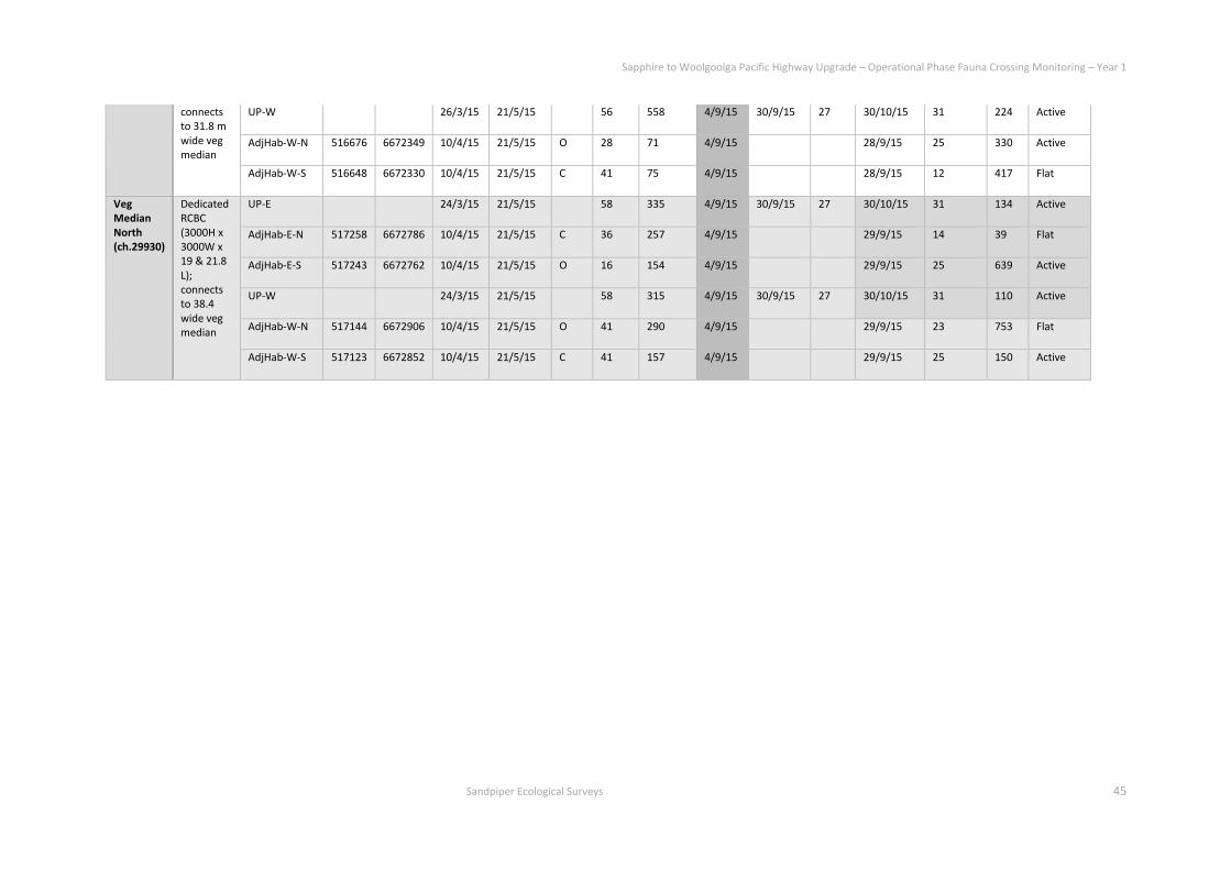
Sapphire to Woolgoolga Pacific Highway Upgrade – Operational Phase Fauna Crossing Monitoring – Year 1
Sandpiper Ecological Surveys 45
connects to 31.8 m wide veg median
UP-W 26/3/15 21/5/15 56 558 4/9/15 30/9/15 27 30/10/15 31 224 Active
AdjHab-W-N 516676 6672349 10/4/15 21/5/15 O 28 71 4/9/15 28/9/15 25 330 Active
AdjHab-W-S 516648 6672330 10/4/15 21/5/15 C 41 75 4/9/15 28/9/15 12 417 Flat
Veg Median North (ch.29930)
Dedicated RCBC (3000H x 3000W x 19 & 21.8 L); connects to 38.4 wide veg median
UP-E 24/3/15 21/5/15 58 335 4/9/15 30/9/15 27 30/10/15 31 134 Active
AdjHab-E-N 517258 6672786 10/4/15 21/5/15 C 36 257 4/9/15 29/9/15 14 39 Flat
AdjHab-E-S 517243 6672762 10/4/15 21/5/15 O 16 154 4/9/15 29/9/15 25 639 Active
UP-W 24/3/15 21/5/15 58 315 4/9/15 30/9/15 27 30/10/15 31 110 Active
AdjHab-W-N 517144 6672906 10/4/15 21/5/15 O 41 290 4/9/15 29/9/15 23 753 Flat
AdjHab-W-S 517123 6672852 10/4/15 21/5/15 C 41 157 4/9/15 29/9/15 25 150 Active
Sapphire to Woolgoolga Pacific Highway Upgrade – Operational Phase Fauna Crossing Monitoring – Year 1
Sandpiper Ecological Surveys 46
Appendix A – Underpass and adjacent habitat data
Table A2: Fauna detected in adjacent habitat during camera-trap surveys in autumn (A) and spring (S) 2015. E = East side of highway; W = West side of highway.
Species Moonee Bch (ded
culv) Emerald Bch
(pipes) Veg Med Sth (ded
culv) Veg Med Nth (ded
culv)
E W E W E W E W
Echidna S S A S A, S
Sp-tail quoll A
Antechinus sp. A A A S
Long-nosed bandicoot A, S S S A, S A, S S
Northern brown b'icoot A S A, S A, S S A, S A, S A, S
Short-eared b'tail possum A A S S S
Common b'tail possun A A, S S A, S
B'tail possum sp. S
Estn grey kangaroo A A, S A, S A, S
Red-necked wallaby S
Swamp wallaby A, S A, S A A, S A, S A, S A, S A, S
Wallaby sp. S
Water rat S
Swamp rat A
Bush rat A(Pr)
Black rat S A
Rodent sp. A, S A, S A, S A, S A A, S
Dog A
Red fox A, S S S A A A

Sapphire to Woolgoolga Pacific Highway Upgrade – Operational Phase Fauna Crossing Monitoring – Year 1
Sandpiper Ecological Surveys 47
Cat A A S
Cow S
Human S
Brush turkey S S S S
Kookaburra A, S A
Buff-banded rail A
Noisy pitta A
Fairy wren sp. A, S
Estn whipbird S
Grey shrike-thrush A, S
Pied currawong S
Lace monitor S A, S S
Eastern water dragon A S S
Land Mullet A, S A
Sapphire to Woolgoolga Pacific Highway Upgrade – Operational Phase Fauna Crossing Monitoring – Year 1
Sandpiper Ecological Surveys 48
Appendix A – Underpass and adjacent habitat data
Table A3: Fauna recorded by cameras in underpasses during autumn and spring 2015. Accuracy/Likelihood: D = Definite; Pr = Probable; Po = Possible.
Date Time Species Accu- racy
Move-ment
Pic No. Crossing Likelihood
Date Time Species Accu- racy
Move-ment
Pic No. Crossing Likelihood
Comments
Moonee Bch East Moonee Bch West
29/3/15 0710 Fox D E,turn,W 116-21 Unlikely
5/4/15 0138 Fox D E 121-25 Pr
11/4/15 0123 Fox D W 136-40 D 11/4/15 0209 Fox D W 71-75 D
11/4/15 0358 Fox D E 141-45 Pr
12/4/15 2102 Fox D E 146-50 Pr
16/4/15 2225 Fox D E 151-55 Pr
26/4/15 1959 Fox D W,turn,E 156-60 No
27/4/15 2249 Fox D W 161-65 Pr
28/4/15 0204 Fox D E 166-70 Pr b'coot? In mouth
4/5/15 600 Fox D E 171-75 Pr
10/5/15 0406 Fox D E 176-80 Pr
11/5/15 1211 Swamp wallaby
D NDM 136-40 Po
5/9/15 0331 Fox D W 46-50 Pr
6/9/15 0855 Humanx3 & dogx2
D W, return E
61-115 D 0858 Humanx3 & dogx2
D W return E
51-85 D
8/9/15 0316 Fox D E,pause,E 116-30 Pr

Sapphire to Woolgoolga Pacific Highway Upgrade – Operational Phase Fauna Crossing Monitoring – Year 1
Sandpiper Ecological Surveys 49
10/9/15 0103 Fox D W 86-90 Pr
10/9/15 0252 Fox D E 131-35 Pr
14/9/15 2144 Fox D E 136-40 Pr
15/9/15 0135
Swamp wallaby
D W 91-95 Pr
16/9/15 0304 Fox D W,turn,E 141-50 Unlikely
17/9/15 2144 Fox D E 151-55 Pr
18/9/15 2335 Fox D E 156-60 Pr
21/9/15 2324 Fox D E 161-65 Pr
22/9/15 0235 Fox D E 166-70 Pr
22/9/15 2006 Fox D E 171-75 Pr
22/9/15 2008 Fox(b) D E & W 176-230
D 22/9/15 2021 Fox D E & W 96-105 D
23/9/15 2432 Fox D E 231-35 Pr
23/9/15 2445 Fox D W 106-110 Pr
23/9/15 2100 Fox D E 236-40 Pr
23/9/15 2233 Fox D E & W 241-255
D 23/9/15 2233 Fox D E & W 111-15 D
24/9/15 2434 Fox D E turn W 116-25 Unlikely
24/9/15 2129 Fox D E 256-60 Pr
26/9/15 0423 Fox D E 261-65 Pr
26/9/15 1950 Fox D W 126-30 Pr
26/9/15 1951 Fox D E 266-70 Pr
29/9/15 0211 Fox D E 271-75 Pr
29/9/15 0419 Fox D E 131-35 Pr

Sapphire to Woolgoolga Pacific Highway Upgrade – Operational Phase Fauna Crossing Monitoring – Year 1
Sandpiper Ecological Surveys 50
29/9/15 2008 Fox D E 56-60 Pr
30/9/15 0157 Fox D E 61-64 Pr
30/9/15 0256 Fox D E 61-64 Pr
30/9/15 0939 Human x2 D W & E 81-125 D 30/9/15 0943 Human x2 D W & E 61-90 D
4/10/15 0257 Fox D W 56-60 Pr
4/10/15 1004 Cyclist x2 D W,turn,E 125-95 Unlikely
5/10/15 1909 Fox D E 96-100 Pr
6/10/15 0313 Fox D E 196-200
Pr
6/10/15 2302 Fox D W 201-05 Pr
7/10/15 0256 Fox D E 101-05 Pr
7/10/15 2032 Fox D E 206-10 Pr
7/10/15 2254 Fox D E 211-15 Pr
8/10/15 0418 Fox D E 216-20 Pr
8/10/15 2300 Fox D E 221-25 D 8/10/15 2259 Fox D E 106-10 D
9/10/15 0428 Fox D E 226-30 Pr
10/10/15 2231 Fox D E 111-15 Pr
11/10/15 2219 Fox D W 116-20 Pr
12/10/15 2014 Swamp wallaby
D W 121-25 Pr
14/10/15 1938 Fox D W & E 231-40 D 14/10/15 1941 Fox D W 126-30 D
17/10/15 0936 Fox D W 241-50 D 17/10/15 0937 Fox D W 131-35 D
17/10/15 1137 Fox D E 251-55 D 17/10/15 1136 Fox D E 136-40 D Bird? in mouth
17/10/15 1446 Fox D W 256-60 D 17/10/15 1447 Fox D W 141-45 D
17/10/15 1617 Fox D E 261-65 D 17/10/15 1617 Fox D E 146-50 D Lizard? in mouth
Sapphire to Woolgoolga Pacific Highway Upgrade – Operational Phase Fauna Crossing Monitoring – Year 1
Sandpiper Ecological Surveys 51
17/10/15 1818 Swamp wallaby
D E turn W 151-65 Unlikely
19/10/15 1148 Lace monitor
D E 266-70 Pr
20/10/15 0845 Fox D W 271-75 D 20/10/15 0846 Fox D W 166-70 D
20/10/15 1046 Fox D E 276-80 D 20/10/15 1046 Fox D E 171-75 D Rodent? in mouth
24/10/15 1930 Fox D E 281-85 Pr
25/10/15 0300 Fox D E 286-90 Pr
25/10/15 1331 Fox D W 291-95 D 25/10/15 1332 Fox D W 176-80 D
25/10/15 1415 Fox D E 296-300
D 25/10/15 1415 Fox D E 181-85 D
25/10/15 2253 Fox D E 301-05 Pr
26/10/15 0008 Fox D W 186-90 Pr
29/10/15 0219 Fox D E 306-10 Pr
30/10/15 0045 Estn grey k'roo x2
D Explore 311-455
Po
Emerald Bch East-North Emerald Bch East-South
28/3/15 0218 Fox D W,turn,E 413-16 Unlikely
28/3/15 1941 Fox D E?,stop 1354-58
Po
12/4/15 1857
Nthn br b'coot
D W 146-48 Pr
23/4/15 0408 Fox D W,turn,E 1557-61
Unlikely
7/5/15 1928 Fox Pr E 1561 Pr
9/5/15 1625 Echidna D Across entrance
1566-69
Po
17/5/15 0336 Fox D W,turn,E 1582 Unlikely
Sapphire to Woolgoolga Pacific Highway Upgrade – Operational Phase Fauna Crossing Monitoring – Year 1
Sandpiper Ecological Surveys 52
18/5/15 0705 Estn grey kangaroo
D Graze E entr
1586-1700
Unlikely
4/9/15 2022 Fox D W? stop 21-25 Po
5/9/15 0149 Fox D W,turn,E 26-30 Unlikely
9/9/15 2257 Fox D W 31-35 Pr
20/9/15 0332
Estn grey kangaroo
D Graze E entr
46-55 Unlikely
28/9/15 2027 Estn grey kangaroo
D Graze E entr
36-145 Unlikely
5/10/15 1229 Lace monitor
D Move past 211-15 Po
14/10/15 1341 Human x2 D Explore 56-80 Unlikely 14/10/15 1343 Human x2 D Explore 216-25 Unlikely
19/10/15 1819 Estn grey kangaroo
D Graze E entr
81-150 Unlikely
Veg Med South-East Veg Med South-West
6/4/15 0918
Swamp wallaby
D E 111-15 Pr
9/4/15 0652
Swamp wallaby
D E 116-20 Pr
9/4/15 0904 Swamp wallaby
D W,stop 101-05 D 9/4/15 0904 Swamp wallaby
D W 121-25 D
8/9/15 0809 Swamp wallaby
Pr E 131-35 Pr
9/9/15 0822 Swamp wallaby
D E 56-60 D 9/9/15 0821 Swamp wallaby
D E 136-40 D
9/9/15 1001 Swamp wallaby
D W 61-65 D 9/9/15 1001 Swamp wallaby
D W 141 D
10/9/15 0451 Swamp wallaby
Pr E,pause,E 146-50 Pr

Sapphire to Woolgoolga Pacific Highway Upgrade – Operational Phase Fauna Crossing Monitoring – Year 1
Sandpiper Ecological Surveys 53
12/9/15 1508 Trail bike D W 66-70 D 12/9/15 1505 Trail bike D W 151-55 D
22/9/15 0821 Swamp wallaby
Pr E 161-65 Pr
27/9/15 0820 Swamp wallaby
Pr W 71-75 Pr
17/10/15 0809 Swamp wallaby
Pr E 61-65 Pr
25/10/15 0537 Estn grey k'roo
D NDM 66-70 Po
25/10/15 0919 Trail bikes x4
D W 71-160 D 25/10/15 0922 Trail bikes x4
D W 171-85 D
Veg Med North-East Veg Med North-West
26/3/15 1817 Swamp wallaby
Pr W 56-60 Pr
1/4/15 1107 Swamp wallaby
D W 81-85 Pr
3/4/15 1045 Trail bikes x2
D E 71-75 D 3/4/15 1044 Trail bikes x2
D E 86-90 D
4/4/15 1314 Trail bikes x3
D W,E,W 76-90 D 4/4/15 1316 Trail bikes x3
D W 95-105 D
5/4/15 1141 Swamp wallaby
D W 106-10 Pr
11/4/15 201 Swamp wallaby
Pr W 151-55 Pr
14/4/15 945 Swamp wallaby
D W,turn,E 156-65 No
26/4/15 1451 Human D W,E 171-90 D 26/4/15 1447 Human D W,E 166-80 D
12/5/15 1740 Swamp wallaby
Pr W 196-200
Pr

Sapphire to Woolgoolga Pacific Highway Upgrade – Operational Phase Fauna Crossing Monitoring – Year 1
Sandpiper Ecological Surveys 54
12/5/15 2056 Swamp wallaby
Pr E 201-205
Pr
12/9/15 0850 Estn grey k'roo x3
D W 51-60 Pr
12/9/15 1511 Trail bike D E 61-65 D 12/9/15 1512 Trail bike D E 76-80 D
17/9/15 1405 R-n wallaby
Pr E 81-85 Pr
26/9/15 0915
Swamp wallaby
Pr E 86-90 Pr
9/10/15 1259 Lace monitor
D W 101-5 Pr
17/10/15 1143 Lace monitor
D W 106-10 Pr
20/10/15 0942 Lace monitor
D W 111-15 Pr
27/10/15 0739 Swamp wallaby
D E 116-20 Pr
Sapphire to Woolgoolga Pacific Highway Upgrade – Operational Phase Fauna Crossing Monitoring – Year 1
Sandpiper Ecological Surveys 55
Appendix B – Vegetated median data
Table B1: Squirrel/sugar glider trap location and effort.
Trap id Easting Northing Tree species Summer 2015
(23-27/3/15)
Spring 2015
(28/9-2/10)
East 1 516871 6672372 White mahogany 4 nights 4 nights
East 2 516924 6672402 White mahogany 4 nights 4 nights
East 3 516945 6672476 Grey ironbark 4 nights 4 nights
East 4 516997 6672503 White mahogany 4 nights 4 nights
East 5 517011 6672536 Tallow wood 4 nights 4 nights
East 6 517040 6672580 Tallow wood 4 nights 4 nights
East 7 517097 6672628 Blackbutt 4 nights 4 nights
East 8 517129 6672650 Tallow wood 4 nights 4 nights
East 9 517155 6672704 Blackbutt 4 nights 4 nights
East 10 517222 6672763 Red mahogany 4 nights 4 nights
Median 1 516835 6672411 Tallow wood 4 nights 4 nights
Median 2 516890 6672477 Small-fruited grey gum 4 nights 4 nights
Median 3 516923 6672523 Pink bloodwood 4 nights 4 nights
Median 4 516952 6672561 Small-fruited grey gum 4 nights 4 nights
Median 5 516975 6672594 Blackbutt 4 nights 4 nights

Sapphire to Woolgoolga Pacific Highway Upgrade – Operational Phase Fauna Crossing Monitoring – Year 1
Sandpiper Ecological Surveys 56
Median 6 517018 6672607 Tallow wood 4 nights 4 nights
Median 7 517061 6672700 P bloodwood 4 nights 4 nights
Median 8 517084 6672718 Blackbutt 4 nights 4 nights
Median 9 517127 6672768 Tallow wood 4 nights 4 nights
Median 10 517185 6672807 Blackbutt 4 nights 4 nights
West 1 516722 6672454 Small-fruited grey gum 4 nights 4 nights
West 2 516772 6672480 White mahogany 4 nights 4 nights
West 3 516801 6672530 Grey ironbark 4 nights 4 nights
West 4 516835 6672540 White mahogany 4 nights 4 nights
West 5 516866 6672594 Tallow wood 4 nights 4 nights
West 6 516911 6672615 White stringybark 4 nights 4 nights
West 7 516973 6672649 Blackbutt 4 nights 4 nights
West 8 516995 6672709 Tallow wood 4 nights 4 nights
West 9 517058 6672758 Tallow wood 4 nights 4 nights
West 10 517075 6672806 Blackbutt 4 nights 4 nights
Sapphire to Woolgoolga Pacific Highway Upgrade – Operational Phase Fauna Crossing Monitoring – Year 1
Sandpiper Ecological Surveys 57
Appendix B – Vegetated median data
Table B2: Trap and nest box (NB) captures. SqG = squirrel glider; SuG = sugar glider; Br = brown; F-f = fawn-footed; recap = recapture
Trap/ NB Location
Date Species (recapture)
Tag no./L or R/colour
In bag wt
Bag wt
Net wt
Sex Upr teeth
Lwr teeth
Vent colour Breeding status Comments
W8-trap 26/3/15 SqG 513/L/Red 296 99 197 M A/B slight Cream Nil secretions Young adult
E3-NB 13/8/15 SuG 509/R/green 225 101 124# F A/B slight Grey 2xPY(~50mm) #Body wt inc pch yng
E10-trap 29/9/15 Br A'chinus 48 13 35 F 8xPY
E5-trap 29/9/15 Br A'chinus 46 14 32 F 7xPY
M2-trap 29/9/15 SqG-recap 513/L 314 110 204 M B slight Cream Slight secretions Tape off
W1-trap 30/9/15 F-f melomys 73 12 61 M
M8-trap 30/9/15 Br A'chinus 46 13 33 F 6xPY
M6-trap 30/9/15 SqG-recap 513/L M B slight Cream Slight secretions Tape off
M2-trap 30/9/15 SqG 510/L/red 228 84 144 F A/B slight Cream 1xPY(10mm)
E3-trap 30/9/15 Br A'chinus 49 13 36 F 8xPY
E10-trap 30/9/15 Br A'chinus 48 12 36 F 8xPY
E3-trap 1/10/15 F-f melomys 70 11 59 M
E8-trap 1/10/15 Br A'chinus 45 11 34 F 7xPY
E9-trap 1/10/15 F-f melomys 94 15 79 F
E10-trap 1/10/15 Br A'chinus 50 15 35 F 6xPY
W4-trap 1/10/15 Br A'chinus F 7xPY
Sapphire to Woolgoolga Pacific Highway Upgrade – Operational Phase Fauna Crossing Monitoring – Year 1
Sandpiper Ecological Surveys 58
W5-trap 1/10/15 F-f melomys M
E10-trap 2/10/15 Br A'chinus 48 13 35 F 8xPY
M7-trap 2/10/15 Br A'chinus 44 13 31 F 8xPY
M6-trap 2/10/15 Br A'chinus 48 13 31 F 8xPY
M4-trap 2/10/15 SqG-recap 510/L/red F 1xPY(10mm)
M3-trap 2/10/15 SqG-recap 513/L M Slight secretions Tape off
W10-trap 2/10/15 F-f melomys 57 12 45 F Nulliporous Dead in trap; no signs of physical damage
W6-trap 2/10/15 Br A'chinus F Escaped
W5-trap 2/10/15 F-f melomys 70 13 57 F
W3-trap 2/10/15 Br A'chinus 44 13 31 F 8xPY
W1-trap 2/10/15 F-f melomys 85 12 73 F

Sapphire to Woolgoolga Pacific Highway Upgrade – Operational Phase Fauna Crossing Monitoring – Year 1
Sandpiper Ecological Surveys 59
Appendix B – Vegetated median data
Table B3: Nest box installation data.
Nest Box ID Install Date
Easting Northing Tree species DBH Ht Aspect
East 1 11.2.15 516871 6672372 White mahogany 6 NE
East 2 11.2.15 516924 6672402 White mahogany 6 E
East 3 11.2.15 516945 6672476 Grey ironbark 6 NNE
East 4 11.2.15 516997 6672503 White mahogany 6 NE
East 5 11.2.15 517011 6672536 Tallow wood 6 NE
East 6 11.2.15 517040 6672580 Tallow wood 6 E
East 7 11.2.15 517097 6672628 Blackbutt 650 6 ENE
East 8 11.2.15 517129 6672650 Tallow wood 550 6 NE
East 9 11.2.15 517155 6672704 Blackbutt 620 6 ENE
East 10 11.2.15 517222 6672763 Red mahogany 400 6 NE
West 1 11.2.15 516722 6672454 Small-fruited grey gum 6 NE
West 2 11.2.15 516772 6672480 White mahogany 6 NE
West 3 11.2.15 516801 6672530 Grey ironbark 6 NNE
West 4 11.2.15 516835 6672540 White mahogany 6 NE
West 5 11.2.15 516866 6672594 Tallow wood 6 ENE
West 6 11.2.15 516911 6672615 White stringybark 6 E
West 7 11.2.15 516973 6672649 Blackbutt 6 NE
West 8 11.2.15 516995 6672709 Tallow wood 6 ENE
West 9 11.2.15 517058 6672758 Tallow wood 6 SE
West 10 11.2.15 517075 6672806 Blackbutt 6 NE

Sapphire to Woolgoolga Pacific Highway Upgrade – Operational Phase Fauna Crossing Monitoring – Year 1
Sandpiper Ecological Surveys 60
Appendix B – Vegetated median data
Table B4: Nest box inspection data for summer-autumn and winter-spring 2015. SuG = sugar glider; SqG = squirrel glider; FtG = feathertail glider. Pr = probable.
Nest Box ID
Summer 2015 Spring 2015
Inspect date
Fauna Signs Condition Inspect date
Fauna Signs Condition Pic no.
Inspect date
Fauna Signs Condition Pic no.
East 1 24/3/15 Nil Nil Good 10/8/15 Nil Good 20 30/9/15 Nil Nil Good 20
East 2 24/3/15 Nil Nil Good 10/8/15 Nil Good 19 30/9/15 Nil Nil Good 19
East 3 24/3/15 Nil Nil Good 10/8/15 SuG Fresh euc leaf nest (exited box)#
Good 18 30/9/15 Nil Old euc leaf nest (SuG or SqG (pr))
Good 18
East 4 24/3/15 Nil Nil Good 10/8/15 Nil Good 17 30/9/15 Nil Nil Good 17
East 5 24/3/15 Nil Nil Good 10/8/15 Nil Old euc leaf nest (SuG/SqG (pr))
Good 16 30/9/15 Nil Old euc leaf nest (SuG or SqG (pr))
Good 16
East 6 24/3/15 Nil Black ants
Good 10/8/15 Nil Good 15 30/9/15 Nil Nil Good 15
East 7 24/3/15 Nil Nil Good 10/8/15 Nil Good 14 30/9/15 Nil Nil Good 14
East 8 24/3/15 Nil Nil Good 10/8/15 Nil Old euc leaf nest (SuG/SqG (pr))
Good 13 30/9/15 Nil Old euc leaf nest (SuG or SqG (pr))
Good 13
East 9 24/3/15 Nil Nil Good 10/8/15 Nil Good 12 30/9/15 Nil Nil Good 12
East 10 24/3/15 Nil Nil Good 10/8/15 Nil Old lvs/bark (rodent/Achinus-po)
Good 11 30/9/15 Nil Old lvs/bark (rodent/Achinus-po)
Good 11
West 1 25/3/15 Nil Nil Good 10/8/15 Nil Good 1 30/9/15 Nil Black ants Good 1
West 2 25/3/15 Nil Nil Good 10/8/15 Nil Good 2 30/9/15 Nil Nil Good 2
West 3 25/3/15 Nil Nil Good 10/8/15 Nil mud wasp nests Good 3 30/9/15 Nil Mud Wasp nests Good 3
West 4 25/3/15 Nil Nil Good 10/8/15 Nil Good 4 30/9/15 Nil Nil Good 4
West 5 25/3/15 Nil Nil Good 10/8/15 Nil Good 5 30/9/15 Nil Black ants Good 5
West 6 25/3/15 Nil Mud wasp nests
Good 10/8/15 Nil Black ants Good 6 30/9/15 Nil Fresh, flouncy euc leaf nest (FtG (pr))
Good 6

Sapphire to Woolgoolga Pacific Highway Upgrade – Operational Phase Fauna Crossing Monitoring – Year 1
Sandpiper Ecological Surveys 61
West 7 25/3/15 Nil Nil Good 10/8/15 Nil Good 7 30/9/15 Nil Fresh euc leaf nest (SuG or SqG (pr))
Good 7
West 8 25/3/15 Nil Black ants
Good 10/8/15 Nil Good 8 30/9/15 Nil Nil Good 8
West 9 25/3/15 Nil Nil Good 10/8/15 Nil Black ants Good 9 30/9/15 Nil Black ants Good 9
West 10 25/3/15 Nil Black ants
Good 10/8/15 Nil Black ants Good 10 30/9/15 Nil Black ants & mud wasp nests Good 10

Sapphire to Woolgoolga Pacific Highway Upgrade – Operational Phase Fauna Crossing Monitoring – Year 1
Sandpiper Ecological Surveys 62
Appendix B – Vegetated median data
Table B5: Hair funnel sampling data for summer-autumn and winter-spring 2015.
Funnel id Easting Northing Tree species DBH Height Summer 2015 Spring 2015
Install Date Collect date
Fauna Install Date
Collect date
Fauna
East 1 516871 6672372 White mahogany
6 11.2.15 24/3/15 13/8/15 1/10/15
East 2 516924 6672402 White mahogany
6 11.2.15 24/3/15 13/8/15 1/10/15
East 3 516945 6672476 Grey ironbark 6 12.2.15 24/3/15 13/8/15 1/10/15 M.cervinipes (pr)
East 4 516997 6672503 White mahogany
6 12.2.15 24/3/15 13/8/15 1/10/15
East 5 517011 6672536 Tallow wood 6 12.2.15 24/3/15 13/8/15 1/10/15
East 6 517040 6672580 Tallow wood 6 12.2.15 24/3/15 13/8/15 1/10/15
East 7 517097 6672628 Blackbutt 650 6 12.2.15 24/3/15 13/8/15 1/10/15 Antechinus sp.
East 8 517129 6672650 Tallow wood 550 6 12.2.15 24/3/15 13/8/15 1/10/15 Antechinus sp.
East 9 517155 6672704 Blackbutt 620 6 12.2.15 24/3/15 13/8/15 1/10/15 M.cervinipes (pr)
East 10 517222 6672763 Red mahogany 400 6 12.2.15 24/3/15 13/8/15 1/10/15 A.stuartii
Median 1 516835 6672411 Tallow wood 310 4 12.2.15 23/3/15 13/8/15 1/10/15 P.breviceps (pr)
Median 2 516890 6672477 Small-fruited grey gum
550 4 12.2.15 23/3/15 13/8/15 1/10/15
Median 3 516923 6672523 Pink bloodwood
320 4 12.2.15 23/3/15 13/8/15 1/10/15 P.breviceps (pr)
Median 4 516952 6672561 Small-fruited grey gum
380 4 12.2.15 23/3/15 13/8/15 1/10/15 P.breviceps (pr)
Median 5 516975 6672594 Blackbutt 480 4 12.2.15 23/3/15 13/8/15 1/10/15 P.breviceps (pr)

Sapphire to Woolgoolga Pacific Highway Upgrade – Operational Phase Fauna Crossing Monitoring – Year 1
Sandpiper Ecological Surveys 63
Median 6 517018 6672607 Tallow wood 430 4 12.2.15 23/3/15 13/8/15 1/10/15 P.breviceps (pr)
Median 7 517061 6672700 Pink bloodwood
400 4 12.2.15 23/3/15 13/8/15 1/10/15 Antechinus sp.
Median 8 517084 6672718 Blackbutt 480 4 12.2.15 23/3/15 13/8/15 1/10/15 Antechinus sp.
Median 9 517127 6672768 Tallow wood 270 4 12.2.15 23/3/15 13/8/15 1/10/15 A.stuartii
Median 10 517185 6672807 Blackbutt 470 4 12.2.15 23/3/15 13/8/15 1/10/15 Antechinus sp.
West 1 516722 6672454 Small-fruited grey gum
6 11.2.15 25/3/15 Antechinus sp. 13/8/15 1/10/15
West 2 516772 6672480 White mahogany
6 11.2.15 25/3/15 Antechinus sp. 13/8/15 1/10/15 Antechinus sp.
West 3 516801 6672530 Grey ironbark 6 11.2.15 25/3/15 13/8/15 1/10/15 Antechinus sp.
West 4 516835 6672540 White mahogany
6 11.2.15 25/3/15 13/8/15 1/10/15 Antechinus sp.
West 5 516866 6672594 Tallow wood 6 11.2.15 25/3/15 13/8/15 1/10/15 A.stuartii
West 6 516911 6672615 White stringybark
6 11.2.15 25/3/15 13/8/15 1/10/15 Antechinus sp.
West 7 516973 6672649 Blackbutt 6 11.2.15 25/3/15 13/8/15 1/10/15
West 8 516995 6672709 Tallow wood 6 11.2.15 25/3/15 Antechinus sp. 13/8/15 1/10/15 Antechinus sp.
West 9 517058 6672758 Tallow wood 6 11.2.15 25/3/15 13/8/15 1/10/15 Antechinus sp.
West 10 517075 6672806 Blackbutt 6 11.2.15 25/3/15 13/8/15 1/10/15 Antechinus sp.

Sapphire to Woolgoolga Pacific Highway Upgrade – Operational Phase Fauna Crossing Monitoring – Year 1
Sandpiper Ecological Surveys 64
Appendix B – Vegetated median data
Table B6: Spotlight effort and detections for summer-autumn and winter-spring 2015.
Site Date Observ ers
Start Time
Finish Time
Species Comments Flowering Moon Wind Rain Visibility Air Temp
Humidity
East 24/3/15 BT/GM 2115 2148 P coriacea(10+,C); Lim peroni(2,C)
1st 1/4 MSb Nil Dark 24 98
26/3/15 BT/GM 2035 2110 P coriacea(10+,C) 1st 1/4 Still Nil Detail seen
28 86.6
30/9/15 BT/GM 1842 1916 Nil Twood full Nil Nil Dark 16.5 80
26/10/15 NP/GM 0025 0055 GHFF (c) Iron bark 7/8 Nil Nil Bright 18.9 100
Median 24/3/15 BT/GM 2030 2110 FtG Mid-tran 1st 1/4 MSb Nil Dark 24 98
26/3/15 BT/GM 2116 2151 Nil 1st 1/4 Still Nil Detail seen
28 86.6
30/9/15 BT/GM 2014 2050 Nil Twood full Msb Nil Dark 13.7 94
26/10/15 NP/GM 2345 0015 Nil Tallow, Bbutt
7/8 Nil Nil Bright 18.5 99
West 24/3/15 BT/GM 1950 2026 Nil Br-l p'bk 1st 1/4 MSb Nil Dark 24 98
26/3/15 BT/GM 2000 2032 M fasciolatus (1c); L fallax(1c)
1st 1/4 Still Nil Detail seen
28 86.6
30/9/15 BT/GM 1931 2005 L.latopalmata(2c) full Msb Nil Dark 16.2 84
26/10/15 NP/GM 2305 2340 L. Latopalmata (>10c), L. fallax (2c), Lit. peronii (1c)
Tallow 7/8 Msb Nil Bright 19 100

Sapphire to Woolgoolga Pacific Highway Upgrade – Operational Phase Fauna Crossing Monitoring – Year 1
Sandpiper Ecological Surveys 65
Appendix C – Rope bridge data
Table C1: Rope bridge camera monitoring survey effort.
Survey period (days)
East cam West cam
Pics Days active
Batteries Comments Pics Days active
Battery %
Comments
9/4/15 (Install) SC950; On:1700,Off:0700; (Lithium); Sense:H; P/trig:5; Rapidfire; Balanced; sandwich board view along rope
SC950; On:1700,Off:0700; (Lithium); Sense:H; P/trig:5; Rapidfire; Balanced; sandwich board view along rope
9/4-14/5/15 (35)
12046 27 0% (L>A) Turn cam to face bulk head 1932 35 99 (L) Time: 1min<
14/5-12/8/15 (90)
66 90 1% (A>L) Sens:High>Med/High; Pics/trig: 5>3 3730 90 99 (L) No change
12/8-30/10/15 (79)
0 79 99% (L) Sens:MH>H; Pics/trig: 3>5 8806 67 0% (L>L) Cam knocked(?) @ right angle; no settings change
30/10-15/12/15 (46)
20 46 99% (L) No change; time 1min< 9905 46 99% (L) No change; time 1min<

Sapphire to Woolgoolga Pacific Highway Upgrade – Operational Phase Fauna Crossing Monitoring – Year 1
Sandpiper Ecological Surveys 66
Appendix C – Rope bridge data
Table C2: Rope bridge camera monitoring detections. NDM = No Directional Movement
Side Date Time Species Accu- racy
Movement Bridge sctn
Pic No. Crossing Likelihood
Comments
E 10/4/15 1710 Kookaburra D perch 358-60 Na
22/5/15 0633 Torresian crow D NDM 1-48 Na
30/5/15 0347 Sugar glider(m) D W, turn, E Edge 49-66 Unlikely
11/11/15 0043 Feathertail glider D Explore Centre 1-20 Unlikely
W 2/11/15 2233 Feathertail glider D West Centre 396 Poss
14/12/15 0127 Feathertail glider D West Centre 9551-5 Unlikely

Sapphire to Woolgoolga Pacific Highway Upgrade – Operational Phase Fauna Crossing Monitoring – Year 1
Sandpiper Ecological Surveys 67
Appendix C – Rope bridge data
Table C3: Rope bridge spotlight survey effort and detections. SuG = sugar glider; SqG = squirrel glider; FtG = feathertail glider. GHFF = grey-headed flying fox; TF = tawny
frogmouth; BB = boobook owl; Pr = probable.
Site Date Observ ers
Start Time
Finish Time
Species Comments Flowering Moon Wind Rain Visibility Air Temp
Humidity
Rope-e 19/5/15 BT&TW 1755 1835 Nil B-l p'bk New Nil Nil Dark 19.2 96
21/7/15 BT/DO 1816 1848 GHFF Wh strbk 1st 1/4
Mlb Light Dark 16.9 87.8
1/10/15 BT/GM 1845 1917 FtG; GHFF, L.lato, L.fallax,
FtG: SM@200s20e Bbutt Full Nil Nil Dark 18.2 71
26/10/15 NP/GM 1940 2020 FtG, Lim. peroni, Lim. tasmaniensis
FtG: SM@350n5w (in flowering Bbutt)
Bbutt 7/8 Nil Light Dark 22.9 87.5
Rope-w 19/5/15 BT&TW 1857 1932 GHFFx2; TF B-l p'bk, b'butt, i'bk
New Nil Nil Dark 19.2 96
21/7/15 BT/DO 1914 1948 GHFF, BB Bl butt 1st 1/4
Mlb Light Dark 16.9 87.8
1/10/15 BT/GM 1933 2010 SuG/SqG; GHFF
SuG/SqG:SE@400n30w Bbutt; Twood
Full Msb Nil Dark 15.6 86
2/10/15 NP/GM 22:00 2240 Lit. latopalmata,
Heavy shower prior Bbutt, Tallow
7/8 Msb Heavy/Light Dark 20.2 95.6

Sapphire to Woolgoolga Pacific Highway Upgrade – Operational Phase Fauna Crossing Monitoring – Year 1
Sandpiper Ecological Surveys 68
Appendix D – Glide pole data
Table D1: Glide pole camera monitoring effort. A camera was placed at the end of the upper and lower arm.
Survey period (days)
Upper/East cam (face west) Lower/North cam (face south)
Pics Days active
Battery %
Comments Pics Days active
Battery %
Comments
9/4/2015 (install)
HC500; (Lithium); Sense:H; P/trig:5; Rapidfire; Balanced
SC950; On:1700,Off:0700; (Lithium); Sense:H; P/trig:5; Rapidfire; Balanced
9/4-14/5/15 (35)
1330 35 88%(L) Time ok 80 35 99%(L) Time ok
14/5-12/8/15 (90)
1835 90 1% (L>A) Time ok 10 90 1% (L>A)
Time ok
12/8-30/10/15 (79)
146 ~60 0%(A>L) Time ok; swap HC500>SC950 60 79 10% (A>L)
Time ok; swap SC950>HC500
30/10-15/12/15 (46)
295 46 99%(L) No change; 8G>4G 413 46 99%(L) No change; 8G>4G

Sapphire to Woolgoolga Pacific Highway Upgrade – Operational Phase Fauna Crossing Monitoring – Year 1
Sandpiper Ecological Surveys 69
Appendix D – Glide pole data
Table D2: Glide pole camera monitoring detections. A camera was positioned at the end of the upper and lower arm. D = definite
Cam Date Time Species Accu- racy
Movement Pic No. Comments
E>W (upper)
11/4-11/5/15 0642 Torresian crow & Australian raven
D NDM >1600 pics
25/4/15 0957 Welcome swallow D perch 851-55
5/5/15 1519 Welcome swallow D perch 1046-51
6/5/15 1258 Welcome swallow D perch 1051-55
7/5/15 1557 Grey butcherbird D NDM 1056-65
17/5-12/8/15 0815 Torresian crow & Australian raven
D NDM ~1700 pics
29/7/15 0938 Welcome swallow D perch 1546-65
6/11-7/12/15 Torresian crow & Australian raven
D NDM >30 pics
6/11-7/12/15 Welcome swallow D perch >30 pics
9/11/15 2357 Feathertail glider D Climb pole top 16-20
13/11/15 2414 Feathertail glider D Explore pole top & arm
66-80
17/11/15 2208 Feathertail glider D Explore arm 86-90
18/11/15 2314 Feathertail glider D Explore arm 91-95
5/12/15 2148 Feathertail glider D Explore arm 251-75 Both cams
6/12/15 0103 Feathertail glider D Explore arm 276-80

Sapphire to Woolgoolga Pacific Highway Upgrade – Operational Phase Fauna Crossing Monitoring – Year 1
Sandpiper Ecological Surveys 70
N>S (lower)
16/4/15 0101 Sugar glider D Explore arm 001-10
23-25/4/15 605 Torresian crow D NDM 11-74
12/7/15 0154 SuG/SqG D NDM 1-5 Ears only
12/9/15 2012 Feathertail glider D Explore arm 1-15
5/10/15 2232 Feathertail glider D Explore arm 16-25
6/10/15 0506 Aust Raven Pr Sit 26-30
15/10/15 2248 Feathertail glider D Explore arm 36-40
21/10/15 2434 Feathertail glider D Explore arm 41-45
23/10/15 0506 Aust Raven D Explore 46-60
6/11-7/12/15 Torresian crow & Australian raven
D NDM >30 pics
6/11-7/12/15 Welcome swallow D perch >30 pics
11/11/15 2209 Sugar glider (f) D Leap up pole from arm
61-65
5/12/15 2146 Feathertail glider D Explore arm 161-65 Both cams

Sapphire to Woolgoolga Pacific Highway Upgrade – Operational Phase Fauna Crossing Monitoring – Year 1
Sandpiper Ecological Surveys 71
Appendix D – Glide pole data
Table D3: Glide pole spotlight survey effort and detections. SuG = sugar glider; SqG = squirrel glider; FtG = feathertail glider. GHFF = grey-headed flying fox; TF = tawny
frogmouth; ONj = owlet nightjar; Pr = probable.
Site Date Observ ers
Start Time
Finish Time
Species Comments Flowering Moon Wind Rain Visibility Air Temp
Humidity
Pole-e 19/5/15 BT&TW 1958 2039 FtG @ck B-l p'bk New Nil Nil Dark 18 86
21/7/15 BT/DO 2022 2057 FtG; SuGx2 FtG:80s of ck; SuG: 80s & 40s of ck
Bl butt 1st 1/4
Mlb Light Dark 15.8 89
1/10/15 BT/GM 2032 2110 FtG FtG:SG@50s of ck Bbutt; Twood
Full Msb Nil Dark 15.6 86
26-27/10/15
NP/GM 0110 0200 Lit. peronii, Lim. peronii
7/8 Msb Nil Detail Seen
19 99
Pole-w 19/5/15 BT&TW 2058 2133 FtG 200S B-l p'bk New Nil Nil Dark 18 86
21/7/15 BT/DO 2113 2148 Nil 1st 1/4
Mlb NIL Dark 15.8 89
1/10/15 BT/GM 2124 2155 Nil Bbutt Full Msb Nil Dark 15 90
8/10/15 BT/NP 2351 2420 ONj Twood 3rd 1/4
Msb Last 24 hrs Dark 16.7 88