OXFORD FALLS VALLEY AND BELROSE NORTH STRATEGIC REVIEW · Page | 2 Draft Oxford Falls Valley &...
84
DRAFT OXFORD FALLS VALLEY AND BELROSE NORTH STRATEGIC REVIEW April 2013
Transcript of OXFORD FALLS VALLEY AND BELROSE NORTH STRATEGIC REVIEW · Page | 2 Draft Oxford Falls Valley &...

DRAFT
OXFORD FALLS VALLEY
AND BELROSE NORTH
STRATEGIC REVIEW
April 2013

EXECUTIVE SUMMARY
The Department of Planning and Infrastructure and Warringah Council have worked in
partnership to prepare the Oxford Falls Valley and Belrose North Strategic Review. The
strategic review covers an area of 1341.4 hectares located approximately 20 kilometres from
the Sydney Central Business District.
The review was initiated in response to stakeholder concern regarding the adequacy of
consultation during the preparation of Warringah Local Environmental Plan 2011 (LEP
2011). The purpose of the strategic review has been to translate the planning controls under
Warringah Local Environmental Plan 2000 (LEP 2000) into the best fit zones and land use
controls under Warringah LEP 2011 and to engage the community in the process.
The draft strategic review has been informed by:
A review of relevant planning legislation, studies, policies and guidelines;
A review of existing information on environmental constraints and infrastructure
provisions,
Extensive stakeholder consultation via a community information evening, notification
letters, website and Manly Daily updates, site visits and consideration of submissions
received during the development of the draft report;
A review of current land use controls; and
Regular Project Control Group (PCG) meetings.
The draft findings of the strategic review do not significantly change the urban development
potential of land in Oxford Falls Valley and Belrose North. This is the role of a future review
(Stage 2), which will involve commissioning major studies as recommended by the Planning
Assessment Commission in its 2009 report of the Review of four sites in Oxford Falls Valley
for Urban Development.
Overall, the strategic review found that the best fit land use zone for the majority of the study
area is the E3 Environmental Management zone. There are however some smaller areas of
land that have been identified for alternative zonings and/or additional permitted uses.
It is intended that the findings of the strategic review inform the development of a planning
proposal by Warringah Council to bring Oxford Falls Valley and Belrose North into
Warringah LEP 2011.

Table of Contents
1.0 INTRODUCTION ................................................................................................................... 1
1.1 Background to the Review .................................................................................................. 1
1.2 Scope of the Review........................................................................................................... 2
1.3 The Study Area .................................................................................................................. 3
Map 001 Study Area Map ..................................................................................................... 4
Map 002 Land Ownership Map ............................................................................................. 5
2.0 STRATEGIC PLANNING FRAMEWORK .............................................................................. 6
2.1 NSW 2021 ......................................................................................................................... 6
2.2 Draft Metropolitan Strategy 2031 ....................................................................................... 6
2.3 Metropolitan Plan 2036 ...................................................................................................... 6
2.4 Draft North East Subregional Strategy ............................................................................... 7
2.5 Living Warringah and the Strategic Community Plan 2012 ................................................ 7
3.0 REVIEW PROCESS/ TRANSLATION METHODOLOGY ...................................................... 9
3.1 Establishment of a Project Control Group .......................................................................... 9
3.2 Probity Planning ................................................................................................................ 9
3.3 Review of Existing Information/ Legislation ........................................................................ 9
3.3.1 Review of Four Sites in Oxford Falls Valley for Urban Development by the
Planning Assessment Commission ................................................................................ 9
3.3.2 Previous Translation of Warringah LEP 2000 into LEP 2011 ......................... 10
Table 1 B2 Oxford Falls Valley and C8 Belrose North Locality summary and E3
Environmental Management zoning summary ............................................................. 12
3.3.3 Relevant Standard Instrument LEP Zones and Landuses .............................. 15
3.3.4 EP&A Act 1979 and EP&A Regulations 2000 – Existing Use Rights .............. 19
3.3.5 Relevant State Environmental Planning Policies ............................................ 19
3.4 Stakeholder Consultation, Site Visits and Consideration of Submissions ......................... 21
Diagram 001 Community Engagement Opportunities during and following the Strategic
Review ......................................................................................................................... 22
3.4.1 Online Correspondence and Information .................................................................... 22
3.4.2 Public Information Session ......................................................................................... 22
3.4.3 Site Visits ................................................................................................................... 23
3.4.4 Submissions during the Strategic Review .................................................................. 23
Map 003 Landuses Observed During Site Visits ................................................................. 24
3.5 Consideration of Key Planning Issues ............................................................................. 25

Table of Contents (cont.)
3.6 Environmental Constraints and Infrastructure Planning Considerations ........................... 27
3.6.1 Primary Environmental Constraints Assessment and Weighting .................... 27
Table 2 Cumulative Level of Environmental Constraint ....................................................... 28
Map 004 Cumulative Level of Environmental Constraints ................................................... 29
3.6.2 Zoning Recommendations based on the Consideration of Primary
Environmental Constraints ........................................................................................... 30
Table 3 Summary of Results of Primary Environmental Constraints Assessment ............... 30
Map 005 Outcome of the Primary Environmental Constraints Analysis ............................... 31
3.7 Secondary Environmental Constraints, Infrastructure and Planning Considerations ........ 32
Map 006 Outcome of the Secondary Environmental Constraints Analysis .......................... 34
4.0 RECOMMENDATION ......................................................................................................... 35
4.1 Outcome of the Strategic Review .................................................................................... 35
Map 007 Proposed Land Zoning Map ................................................................................. 37
Map 008 Proposed Additional Permitted Uses Map ............................................................ 38
4.2 Implementing the Recommendations of the Strategic Review ......................................... 39
Warringah Local Environmental Plan 2011 ......................................................................... 39
Section 117 Directions ........................................................................................................ 41
5.0 NEXT STEPS ..................................................................................................................... 42
References ................................................................................................................................ 43
Appendix 1 ................................................................................................................................. 45
Appendix 2 ................................................................................................................................. 49
Appendix 3 ................................................................................................................................. 54
Appendix 4 ................................................................................................................................. 54
Appendix 5 ................................................................................................................................. 57
Appendix 6 ................................................................................................................................. 64
Appendix 7 ................................................................................................................................. 68
Appendix 8 ................................................................................................................................. 71
Appendix 9 ................................................................................................................................. 73

Page | 1 Draft Oxford Falls Valley & Belrose North Strategic Review
1.0 INTRODUCTION
1.1 Background to the Review
A range of reforms were made in September 2005 to the Environmental Planning and
Assessment Act, 1979 (EP & A Act) including the gazettal of the New South Wales
Government’s Standard Instrument (Local Environmental Plans) Order 2006 which required
that all New South Wales councils prepare new comprehensive Local Environmental Plans
(LEPs) in a standard instrument format.
Warringah LEP 2000 is a unique local planning instrument which took a ‘place based’
approach to landuse planning rather than relying on traditional land use zones. It embodied
the concept of ‘a one stop planning shop’ in that all applicable State Environmental Planning
Policies (SEPPs) and Development Control Plans (DCPs) were contained within the one
document.
A place based plan presented unique challenges for Warringah Council, relative to other
councils, because translating this document into the standard instrument format required
rationalising 73 place based ‘localities’ into standard instrument zones.
Localities B2 Oxford Falls Valley and C7 Belrose North (shown on Map 001) were proposed
to be zoned E3 Environmental Management in the draft version of Warringah’s standard
instrument. This was based on a detailed translation methodology that was applied to all
land within Warringah LGA.
The draft Warringah LEP 2011 was exhibited from 12 October to 30 December 2009. The
Minister for Planning and Infrastructure, Department of Planning and Infrastructure and
Council received a number of submissions with regard to the proposed E3 Environmental
Management zoning for land within the Oxford Falls Valley and Belrose North. The issues
raised in the submissions included:
a view that current controls under Warringah LEP 2000 allow for a greater range of
potential development activities compared to the proposed E3 Environmental
Management zone;
a view that the E3 Environmental Management zone is not appropriate for cleared
land or land adjacent to existing residential areas;
an objection to the need to rely on existing use rights;
an objection to the loss of the permissibility of seniors housing for some land
adjoining urban areas;
support for the protection of the environment (sensitive bushland areas; threatened
species, natural rock formations, water catchments and aesthetic qualities) via E3
Environmental Management or E2 Environmental Conservation zones; and
an objection to the level of public consultation in the preparation of the draft LEP.
In response to the submissions received, on 31 August 2011, the Minister for Planning and
Infrastructure announced that he intended to defer the areas of Oxford Falls Valley and
Belrose North from Warringah LEP 2011. On 9 December 2011, when Warringah LEP 2011
was made, both Oxford Falls Valley and Belrose North localities were deferred, meaning that
planning controls under LEP 2000 continue to apply to this land.

Page | 2 Draft Oxford Falls Valley & Belrose North Strategic Review
On 5 June 2012, Council resolved to undertake a joint strategic review with the Department
of Planning and Infrastructure of the Oxford Falls Valley and Belrose North localities.
1.2 Scope of the Review
The scope of works for the strategic review includes:
1. Review existing information on constraints imposed by the physical environment (eg
bushfire risk, flora and fauna, topography). This included a review of constraints
models used in the previous assessment of this area;
2. Review existing provision/needs for infrastructure;
3. Identify existing land uses and establishing whether existing and continuing use
rights apply in the deferred area;
4. Review development that is generally not consistent with the desired future character
of the locality (Category 3 uses under the Warringah LEP 2000) and identifying
landuses that are suitable based on the findings of tasks 1 and 2;
5. Determine an agreed policy position in relation to the use of special uses zones and
additional uses for future planning controls under the Draft LEP in the deferred areas;
6. Identify sites where:
the E3 Environmental Management zone should remain as previously exhibited;
additional uses could be added to the E3 Environmental Management zoning; or
a different zone could apply such as SP2 Infrastructure, R2 Low Density
Residential, RU4 Primary Production Small Lots or R5 Large Lot Residential;
7. Review proposed changes to the E3 Environmental Management zone in the
deferred area and considering implications of clause 6.6 of the LEP (“Erection of
dwelling houses in Zone E3 Environmental Management”) on land holdings within the
proposed zone;
8. Undertaking community engagement and consultation to gather views of key
stakeholders; and
9. Recommending proposed land use zones and other relevant planning controls for
inclusion in a planning proposal.

Page | 3 Draft Oxford Falls Valley & Belrose North Strategic Review
1.3 The Study Area
The study area comprises approximately 1341 hectares of land located within the Warringah
Local Government Area (LGA). The land is located in the vicinity of Wakehurst Parkway and
Forest Way, as shown on the Study Area Map (Map 001).
The land is bounded by Garigal National Park to the north and west. It forms part of the
Narrabeen Lagoon and Middle Harbour catchments and adjoins predominantly low density
residential development to the south.
The majority of land within the study area is characterised by large lots containing significant
patches of native vegetation. Some allotments contain residential dwellings, outbuildings,
educational establishments and commercial uses. The land in the study area has been
cleared to varying degrees.
There are a number of large landowners in the study area including:
the Metropolitan Local Aboriginal Land Council (MLALC) owning approximately 37%
of land;
the Crown owning 24% of the land;
private landowners owning 28% of the land; and
infrastructure providers and/or various government departments owning 11% of the
land.
This is illustrated on the Land Ownership Map (Map 002).

Page | 4 Draft Oxford Falls Valley & Belrose North Strategic Review
Map 001 Study Area Map

Page | 5 Draft Oxford Falls Valley & Belrose North Strategic Review
Map 002 Land Ownership Map

Page | 6 Draft Oxford Falls Valley & Belrose North Strategic Review
2.0 STRATEGIC PLANNING FRAMEWORK
2.1 NSW 2021
NSW 2021: A Plan to make NSW number one is the government’s strategic business plan,
which sets the priorities for action by the government.
There are three key goals in the Plan that are relevant to this strategic review.
Firstly the Plan seeks to involve the community in decision making on government policy,
services and projects. This strategic review has planned for consultation events to ensure
stakeholders can provide input for consideration at key points in the review process.
Secondly, the government’s goal is to strengthen our local environment and improve
people’s lives by protecting natural environments. The strategic review seeks to ensure that
areas of natural value will continue to be protected through the use of environmental
protection zones.
Finally, the Plan’s goal is to place downward pressure on the cost of living. Although the
strategic review will not increase the development potential of land in the study area, it will
ensure that the supply of land for housing is not reduced.
2.2 Draft Metropolitan Strategy 2031
The Draft Metropolitan Strategy is the latest strategy released by the Department of Planning
and Infrastructure to set the framework for Sydney’s growth to 2031 and beyond.
The draft Strategy lays a strong and ambitious strategic planning foundation for the
metropolitan region that will put Sydney on course to cement its position as Australia’s pre-
eminent city. To achieve this, the focus of the Strategy is on boosting housing and job
growth across Sydney.
Under the Draft Metropolitan Strategy, the Oxford Falls Valley and Belrose North area is
identified as an area of rich environmental significance and an asset that Sydney must retain
and protect.
The Draft Metropolitan Strategy for Sydney is available for comment until 31 May 2013. For
more information, visit http://strategies.planning.nsw.gov.au/MetropolitanStrategyforSydney.aspx
2.3 Metropolitan Plan 2036
The Metropolitan Plan for Sydney 2036 aims to integrate land use planning and transport
planning across the city to provide a framework for sustainable growth and development.
The Metropolitan Plan was prepared with the vision that, by 2036, Sydney will be a more
compact, networked city with improved accessibility, capable of supporting more jobs,
homes and lifestyle opportunities within the existing urban footprint.
A key action of the Metropolitan Plan is to locate 80 per cent of new housing within walking
distance of existing or planned centres (this radius increases with the size of the centre i.e.
150m for a Neighbourhood centre up to 2km for a Regional city).

Page | 7 Draft Oxford Falls Valley & Belrose North Strategic Review
Although the aim of this strategic review is to identify development controls that most closely
reflect existing planning controls for the area, it is important to note that the area is relatively
isolated from key centres which provide jobs and services.
2.4 Draft North East Subregional Strategy
The draft North East Subregional Strategy was prepared by the Department of Planning and
Infrastructure in 2007.
It contains targets for housing and employment to 2031 in response to the forecast growth of
Sydney contained in the 2005 Metropolitan Strategy.
Under the draft North East Subregional Strategy, the Warringah LGA has a dwelling target of
10,300 new homes and an employment target of 12,500 new jobs.
There is currently a lack of housing diversity in the Warringah LGA compared to Sydney in
general. The breakdown of existing dwelling stock in the LGA is:
Detached dwellings (63.3%)
Villa/townhouse/dual occupancy (13.9%)
Unit/apartment (22.8%)
Oxford Falls Valley and Belrose North are identified in the draft Strategy as non-urban land.
The draft strategy also highlights that there is no need to develop non–urban lands (not
already identified on the Metropolitan Development Program) to meet the dwelling targets for
the North East subregion to 2031.
Protecting the subregion’s unique diversity of plants and animals is an aim of the draft
Strategy because the subregion is rich in natural heritage and wildlife, and contains
threatened species (flora and fauna). The majority of open space in the subregion is made
up of bushland, including Ku–ring–gai Chase and Garigal national parks. The strategic
review identifies areas of natural value that will continue to be protected and enhanced.
2.5 Living Warringah and the Strategic Community Plan 2012
Living Warringah adopted by Council on 22 November 2005, is Warringah’s strategic plan
for the next ten years. The plan includes a vision to create a vibrant community, improve
quality of life by living and working in balance with the bush and beach environment.
Warringah is renowned for its natural beauty and Living Warringah acknowledges the
communities’ concern about conserving the environment and managing the impact from
development and visitors.
The Plan’s goals are to protect environmental biodiversity through bushland conservation,
reserve networks and responsible land management.

Page | 8 Draft Oxford Falls Valley & Belrose North Strategic Review
The Warringah Strategic Community Plan 2012 aims to align the vision for the area with a
strategic direction for its long term future. The Strategic Community Plan 2012 aims to plan
appropriately for future housing in Warringah, balancing State Government growth targets,
the changing demographic profile of the community, local needs and expectations, the need
to reduce carbon emissions and resource consumption and the challenges of infrastructure
limitations.
The strategic review satisfies the aims of Living Warringah and Warringah Strategic
Community Plan 2012, as it will ensure environmentally valuable land is protected, while not
reducing the development potential on land that currently permits development.

Page | 9 Draft Oxford Falls Valley & Belrose North Strategic Review
3.0 REVIEW PROCESS/ TRANSLATION METHODOLOGY
In identifying an appropriate translation of zones for the study area, the project team
identified seven key steps in the process:
Establish of a Project Control Group;
Establish Probity Protocols;
Review existing information /legislation;
Stakeholder consultation;
Consider key planning issues;
Consider environmental constraints and infrastructure planning requirements; and
Determine best fit zones and other planning controls.
3.1 Establishment of a Project Control Group
A Project Control Group (‘PCG’) consisting of Department and Council representatives was
established to prepare and deliver the strategic review.
The PCG is responsible for detailing the scope of the study, developing a program,
preparing briefs to engage a consultant to undertake a community consultation event,
reviewing available data including submissions made by landowners and occupiers within
the study area and drafting the strategic review report.
3.2 Probity Planning
Vic Baueris from Procure Group was engaged by the PCG as the probity advisor to ensure
the strategic review is carried out with a high level of transparency.
The potential for perceived conflicts of interest was acknowledged due to:
Land ownership by Warringah Council and State Government; and
The decision to await the findings, conclusions and recommendations of the strategic
review before progressing a planning proposal for the area.
The probity advisor provided advice on the governance structure and protocols adopted by
the PCG in preparing the strategic review and will audit its performance at the completion of
the strategic review.
3.3 Review of Existing Information/ Legislation
3.3.1 Review of Four Sites in Oxford Falls Valley for Urban Development by the Planning
Assessment Commission
In 2009, the Planning Assessment Commission (PAC) undertook a review of four sites in the
Oxford Falls Valley locality to determine whether the sites had potential for urban
development.
The PAC concluded that none of the sites were capable of urban development for at least
ten years because the sites do not substantially meet the sustainability criteria of the 2005
Metropolitan Strategy, particularly in relation to transport, access, housing diversity,
environmental constraints and potential land use conflicts.

Page | 10 Draft Oxford Falls Valley & Belrose North Strategic Review
The PAC recommended that six major studies be undertaken to determine the future urban
development capability of the area. These studies include:
Transport and accessibility;
Management of bushfire hazards;
Water quality, aquatic ecology and hydrology of Narrabeen Lagoon and its catchments;
Flora and fauna protection;
Visual analysis; and
Satellite communication buffers.
The PAC studies are a separate process, not to be confused with this strategic review and
will require additional resources and timing. It will form the second stage of work to be
completed for the area to determine future urban development potential. This work will follow
on from this (stage one) strategic review.
3.3.2 Previous Translation of Warringah LEP 2000 into LEP 2011
In translating Warringah LEP 2000 into the standard instrument format, Warringah Council
undertook the following process:
Considered standard zone objectives against desired future character statements;
Included additional local objectives that capture the intent of the desired future character statements;
Identified category 1 and category 2 land uses as (generally) being permitted;
Identified category 3 and prohibited land uses as being (generally) prohibited;
Considered built form controls of LEP 2000 in terms of their outcomes;
Identified provisions that replicated SEPP Seniors Housing and removing them from the LEP; and
Considered environmental constraints mapping.
Following this process, Warringah Council proposed to zone five localities E3 Environmental
Management in the Draft LEP 2011 including:
A7 Mona Vale Road North
B2 Oxford Falls Valley
B9 Mona Vale Road East
C8 Belrose North
C10 Mona Vale Road West

Page | 11 Draft Oxford Falls Valley & Belrose North Strategic Review
These localities were identified as being appropriate for environmental protection for the
following reasons:
1. Desired Future Character
The desired future character statements for all five localities contained the following
requirements:
Present character will remain unchanged;
Natural landscapes will be protected and enhanced;
Housing density will be limited to 1 dwelling per 20 ha; and
Future development will be low intensity and low impact.
2. Categorisation of Land Uses
Almost all land uses were permitted in all localities under LEP 2000 with very few land uses
prohibited. For example, the C1 Middle Harbour Suburbs Locality included the residential
suburbs of Frenchs Forest, Forestville, Davidson and similar suburbs. In this locality, land
uses such as industries (eg. foundries, surf board makers), bulky goods shops, vehicle
repair stations and warehouses were permitted.
LEP 2000 categorised permitted land uses into three groups.
Category One land uses are presumed consistent with the Desired Future Character
statement for the locality.
Category Two land uses may be consistent with the Desired Future Character
statement for the locality.
Category Three land uses are generally inconsistent with the Desired Future Character
of the locality. Referring to Locality C1 Middle Harbour Suburbs, the following uses
were Category 3 uses in this locality:
o Industries (foundries, surf board makers);
o Bulky goods shops;
o Vehicle repair stations; and
o Warehouses.
LEP 2000 applied different tests for development in the three categories. The test for
Category Three land use applications was significantly more rigorous than that for Category
One or Two land uses. It was based on an independent hearing and was largely based on
impact of the development on the area and on the Desired Future Character of the locality.
Recognising the environmental sensitivity of the land in certain areas, 5 out of 74 localities in
LEP 2000 were proposed to be zoned E3 Environmental Management. None of the five
localities included Category One land uses. This means that no land uses were considered
to be consistent with the relevant desired future character statement and all development
applications were to be assessed under the more rigorous requirements for Category Two
and Three land uses. In addition, all five localities included the highest number of land uses
under Category Three.
3. Built Form Controls
The translation process recognised that the housing density standard of 1 dwelling per 20
hectares exclusively applied to the five localities. Other non urban localities in Warringah
LGA had a housing density standard of 1 dwelling per 2 hectares which recognised the lower
level of environmental constraints in these localities.

Page | 12 Draft Oxford Falls Valley & Belrose North Strategic Review
4. Removal of State Environmental Planning Policies (SEPPs) from Warringah’s LEP
At the time of preparing LEP 2000, Council incorporated SEPPs into the LEP. The SEPPs
then ceased to apply to Warringah because the relevant controls were included in the LEP.
Provisions from SEPP 5 Seniors Living were included in LEP 2000 and seniors housing was
permitted on non-urban land, if the land adjoined land primarily used for urban purposes.
Since LEP 2000 was made, controls relating to seniors housing under the SEPP became
more rigorous. The SEPP no longer applied to land adjoining an urban area if the land was
environmentally sensitive. In addition, a Site Compatibility Certificate is now to be issued first
for land adjoining an urban area before seniors housing development can be considered.
The more rigorous controls were not translated into LEP 2000.
When making LEP 2011, Warringah Council did not incorporate SEPPs into its LEP.
Therefore, provisions relating to SEPP 5 were removed. This approach was supported by
the Department.
5. Special Purpose Zones and Schedule 1 (Additional Permitted Uses)
In preparing LEP 2011, Council restricted its use of the Special Purpose (SP) zones. Many
land uses that had historically been zoned SP adopted the prevalent surrounding zone. In
particular, this principle was applied to schools. Hence, in the non urban areas of
Warringah, schools are zoned RU4 Primary Production Small Lots or E3 Environmental
Management.
In preparing LEP 2011, the Department of Planning and Infrastructure advised Council that
Clause 28(2) of the State Environmental Planning Policy (Infrastructure) 2007 allows for the
development and expansion of existing educational establishments (including private
schools). Therefore, the inclusion of such sites in Schedule 1 (Additional Permitted Uses)
was not necessary. This position remains current.
Table 1 identifies a comparison of the two localities against the E3 Environmental
Management zone that was initially proposed for the two localities under LEP 2011.
Table 1 B2 Oxford Falls Valley and C8 Belrose North Locality summary and E3 Environmental
Management zoning summary
Locality B2 Oxford Falls
Valley (LEP 2000)
Locality C8 Belrose North
(LEP 2000)
E3 Environmental
Management (LEP 2011)
Desired Future Character,
Locality Statement:
The present character will
remain unchanged.
Future development will be
limited to new detached style
and low intensity, low impact
uses.
There will be no new
development on ridgetops or in
places that will disrupt the
skyline when viewed from
Narrabeen lagoon and the
Wakehurst Parkway.
Desired Future Character,
Locality Statement:
The present character will
remain unchanged.
The natural landscape will be
protected.
Buildings will be grouped in
areas that will result in the
minimum amount of
disturbance of vegetation.
Development will be limited to
new detached style housing
and low intensity, low impact
Objectives of zone
•To protect, manage and
restore areas with special
ecological, scientific, cultural
or aesthetic values.
•To provide for a limited range
of development that does
not have an adverse effect
on those values.
•To ensure that development,
by way of its character,
design, location and
materials of construction, is
integrated into the site and
natural surroundings,

Page | 13 Draft Oxford Falls Valley & Belrose North Strategic Review
Locality B2 Oxford Falls
Valley (LEP 2000)
Locality C8 Belrose North
(LEP 2000)
E3 Environmental
Management (LEP 2011)
The natural landscape will be
protected.
Buildings will be located and
grouped in areas that will
minimise disturbance of
vegetation.
A dense bushland buffer will be
retained or established along
Forest Way and Wakehurst
Parkway.
Development in the locality will
not create siltation or pollution
of Narrabeen lagoon and its
catchment.
uses.
A dense bushland buffer will
be retained along Forest
Way.
Development in the locality
will not create siltation or
pollution of Middle Harbour.
complements and enhances
the natural environment and
has minimal visual impact.
•To protect and enhance the
natural landscape by
conserving remnant
bushland and rock outcrops
and by encouraging the
spread of an indigenous tree
canopy.
•To protect and enhance visual
quality by promoting dense
bushland buffers adjacent to
major traffic thoroughfares.
Category one
Nil.
Category two
Agriculture
housing
seniors housing but only on
land that adjoins land used for
urban purposes
Category one
Development for the purpose
of extractive industries (on
land covered by licence
number 64/193 metropolitan,
Belrose—Warringah Gravel
and Stone Supplies).
Category two
Agriculture
housing
seniors housing but only on
land that adjoins land used
for urban purposes
Permitted Without Consent
Home-based child care; Home
occupations
Permitted With Consent
Aquaculture;
Bed and breakfast
accommodation;
Building identification signs;
Business identification signs;
Community facilities;
Dwelling houses;
Emergency services facilities;
Environmental facilities;
Environmental protection
works;
Extensive agriculture;
Farm buildings;
Home businesses;
Home industries;

Page | 14 Draft Oxford Falls Valley & Belrose North Strategic Review
Locality B2 Oxford Falls
Valley (LEP 2000)
Locality C8 Belrose North
(LEP 2000)
E3 Environmental
Management (LEP 2011)
Horticulture;
Recreation areas;
Roads
Category three
animal boarding or training
establishments
bulky goods shops
business premises
child care centres
community facilities
entertainment facilities
further education
health consulting rooms
heliports
hire establishments
hospitals
hotels
industries
medical centres
motor showrooms
offices
places of worship
primary schools
recreation facilities
registered clubs
restaurants
retail plant nurseries
service stations
shops
short term accommodation
Category three
animal boarding or training
establishments
bulky goods shops
business premises
child care centres
community facilities
entertainment facilities
extractive industries, unless
this locality statement
provides otherwise
further education
health consulting rooms
heliports
hire establishments
hospitals
hotels
industries
medical centres
motor showrooms
offices
places of worship
primary schools
recreation facilities
registered clubs
restaurants
retail plant nurseries
service stations
Prohibited development
Industries;
Multi dwelling housing;
Residential flat buildings;
Retail premises;
Seniors housing;
Service stations;
Warehouse or distribution
centres;
Any other development not
specified in item 2 or 3

Page | 15 Draft Oxford Falls Valley & Belrose North Strategic Review
Locality B2 Oxford Falls
Valley (LEP 2000)
Locality C8 Belrose North
(LEP 2000)
E3 Environmental
Management (LEP 2011)
vehicle repair stations
veterinary hospitals
warehouses
Prohibited development
brothels
extractive industries
Seniors housing
potentially hazardous industries
potentially offensive industries
vehicle body repair workshops
canal estate development
shops
short term accommodation
vehicle repair stations
veterinary hospitals
warehouses
Prohibited development
brothels
seniors housing
potentially hazardous
industries
potentially offensive
industries
vehicle body repair
workshops
canal estate development
Housing density
The maximum housing density
is 1 dwelling per 20ha of site
area, with exceptions (refer to
LEP 2000 locality statement)
Housing density
The maximum housing
density is 1 dwelling per 20
ha of site area, with
exceptions (refer to LEP 2000
locality statement)
Housing density
The maximum housing density
is 1 dwelling per 20 ha of site
area, with exceptions (Clause
6.6 of LEP 2011)
Building height
Buildings are not to exceed 8.5
metres in height.
Building height
Buildings are not to exceed
8.5 metres in height.
Building height
Buildings are not to exceed 8.5
metres in height.
3.3.3 Relevant Standard Instrument LEP Zones and Landuses
The Standard Instrument Order 2006 sets out 35 standard zones for councils to use when
preparing their new LEPs. This review considered a range of zones which are summarised
below. Further zoning information is available in LEP Practice Note PN11-002 Preparing
LEPs using the Standard Instrument: standard zones.

Page | 16 Draft Oxford Falls Valley & Belrose North Strategic Review
Rural Zones
RU4 Primary Production Small Lots
The RU4 Primary Production Small Lots zone is intended for land which is to be used for
commercial primary industry production and not for land that is primarily residential in
function. Warringah Council currently applies this zone in Duffys Forest and Terrey Hills.
Residential Zones
R2 Low Density Residential Zone
The R2 Low Density Residential zone is the lowest density urban residential zone which
aims to provide for the housing needs of the community within a low density residential
environment. The zone is generally restricted to services that meet the day-to-day needs of
residents.
Warringah LEP 2011 applies the R2 Low Density Residential zone in large parts of the LGA
and permits uses such as boarding houses, dwelling houses and group homes.
R3 Medium Density Residential Zone
The R3 Medium Density Residential zone is for land comprising of medium density
accommodation. A variety of residential uses have been mandated in the zone to encourage
housing choice and diversity. The R3 Medium Density Residential zone is generally applied
in locations close to or within centres with a diverse range of established services and
infrastructure.
Warringah LEP 2011 contains the R3 Medium Density Residential zone, and permits
attached dwellings, dual occupancies, dwelling houses, multi dwelling housing,
neighbourhood shops, residential flat buildings and seniors housing.
R5 Large Lot Residential Zone
The R5 Large Lot Residential zone is intended to cater for development that provides for
residential housing in a rural setting and is generally located at the interface of
environmentally sensitive land along one boundary and urban land along the other.
Warringah LEP 2011 does not currently use the R5 Large Lot Residential zone.
Business Zones
B1 Neighbourhood Centre Zone
The B1 Neighbourhood Centre zone is intended for small scale centres that include
commercial premises that serve the day-to-day needs of residents. This zone should not be
used for single ‘neighbourhood shops,’ as these can generally be permitted within the
residential zones.
Warringah LEP 2011 uses the B1 Neighbourhood Centre zone, which aims to provide for a
range of small-scale retail, business and community uses and permits business premises,
shop top housing and shops.

Page | 17 Draft Oxford Falls Valley & Belrose North Strategic Review
B2 Local Centre Zone
The B2 Local Centre zone is generally intended for centres that provide a range of
commercial, civic, cultural and residential uses.
Warringah LEP 2011 uses the B2 Local Centre zone, which aims to provide a range of retail,
business, entertainment and community uses and permits commercial premises and shop
top housing.
B6 Enterprise Corridor Zone
This zone is generally applied where commercial or industrial development is to be
encouraged.
Warringah Council does not currently apply this zone.
Environmental Protection Zones
E2 Environmental Conservation Zone
The E2 Environmental Conservation zone is intended to protect land that has high
conservation values outside national parks and nature reserves. The use of this zone needs
to be justified by appropriate evaluation of the area in terms of high ecological, scientific,
cultural or aesthetic attributes.
The following are examples of land where the E2 Environmental Conservation zone should
be applied:
Lands with very high conservation values;
High conservation coastal foreshores or subject to coastal hazards;
Land with a registered BioBanking agreement;
Land with significant Aboriginal heritage values; and
Land currently zoned for environmental protection with strict controls on development.
Warringah LEP 2011 currently applies the E2 Environmental Conservation zone in several
locations adjoining national parks and land used for public recreation.
E3 Environmental Management zone
The E3 Environmental Management zone is to be applied to land that has special ecological,
scientific, cultural or aesthetic attributes, or land highly constrained by geotechnical or other
hazards. This zone might also be suitable as a transition between areas of high conservation
value and other more intensive land uses.
The Environmental Management zone may be applied on land:
With special ecological, scientific, cultural or aesthetic attributes;
Where rehabilitation of the land’s environmental qualities is required, as a transition
between high conservation value land and other land;

Page | 18 Draft Oxford Falls Valley & Belrose North Strategic Review
With native vegetation or forest cover; and
That is highly constrained where slope, erodible soils or salinity may have a key impact
on water quality.
Warringah LEP 2011 uses the E3 Environmental Management zone for 3 former localities:
Mona Vale Road North, Mona Vale Road East and Mona Vale Road West.
E4 Environmental Living Zone
The E4 Environmental Living zone is intended for land with special environmental or scenic
values and accommodates low impact residential development.
Warringah LEP 2011 uses the E4 Environmental Living zone at Cottage Point.
Special Purpose Zone
SP2 Infrastructure
The SP2 Infrastructure zone is intended to cover a wide range of physical and human
infrastructure uses such as transport (roads and railways), utility undertakings and works,
community uses such as churches, educational establishments (schools) and hospitals.
However in some instances, it is more suitable for small infrastructure uses to be zoned the
surrounding zone because SEPP (Infrastructure) 2009 permits certain infrastructure in the
prescribed zone.
Warringah Council has applied the SP2 Infrastructure zone sparingly under LEP 2011 and
has generally zoned educational establishments and churches to the prevalent surrounding
zone rather than SP2 Infrastructure.
Schedule 1 - Additional Permitted Uses
Clause 2.5 of the Standard Instrument Order allows councils to permit additional uses for
particular land. These uses are permitted in addition to those identified in the LEP Land Use
Table or other planning instruments such as the ISEPP. Additional permitted uses are to be
inserted in Schedule 1 of the LEP and may be mapped.
For clarity, land use permissibility should preferably be controlled by the zones and the Land
Use Table. Where this is not possible and the intended outcome is adequately justified by
council, the use of Schedule 1 may be acceptable. Generally, additional listings under LEP
Schedule 1 should be minimised and should only proceed where council can demonstrate
that there is no other acceptable zoning solution.
For the purposes of this strategic review, it was agreed that the use of Schedule 1 would be
used sparingly and only in circumstances where it is difficult for the land use permissibility to
be controlled by the Land Use Table. Generally, it is proposed that anomalous or non
conforming sites are managed by existing use rights provisions of the Environmental
Planning and Assessment Act 1979.
Warringah LEP 2011 currently has 18 items listed under Schedule 1.
Schedule 1(18) relates to the use of certain land in the vicinity of Mona Vale and Myoora
Roads, Terrey Hills (Area 1). This land is zoned RU4 Primary Production Small Lots but
Schedule 1 also allows for:

Page | 19 Draft Oxford Falls Valley & Belrose North Strategic Review
educational establishments, garden centres, hospitals, hotel or motel
accommodation, places of public worship, recreation areas, recreation facilities
(indoor), recreation facilities (outdoor), registered clubs and restaurants or cafes.
Part of this strategic review considers whether it is suitable for Schedule 1(18) controls to be
expanded to parts of the study area.
3.3.4 EP&A Act 1979 and EP&A Regulations 2000 – Existing Use Rights
Whilst every effort has been made to eliminate the number of non-conforming uses, there
will be a small number of non-conforming land uses as a result of the recommended zoning.
It is recommended that these properties rely on existing use rights under the Environmental
Planning and Assessment Act, 1979 (EP&A Act) and the Environmental Plan and
Assessment Regulations, 2000 (EP&A Regulations).
An existing use (defined in section 106 of the EP&A Act) is a use that is lawfully commenced
but subsequently becomes a prohibited use under a new LEP or other Environmental
Planning Instrument (EPI). In simplified terms, existing use rights allow for a land use to
operate the same lawfully established use on a parcel of land subject to the provisions of the
EP&A Act and EP&A Regulations (relevant extracts at Appendix 1).
3.3.5 Relevant State Environmental Planning Policies
State Environmental Planning Policies (SEPPs) deal with issues significant to the state.
They are made by the Minister for Planning and Infrastructure. As an environmental planning
instrument that is ranked above an LEP, it overrides any inconsistencies with an LEP. A list
of SEPPs relevant to this strategic review are outlined below.
SEPP (Infrastructure) 2007
SEPP (Infrastructure) 2007 (ISEPP) provides a consistent planning regime for infrastructure
(including educational establishments) and the provision of services across New South
Wales.
Specifically, Clause 28(2) of the ISEPP states that:
(2) Development for any of the following purposes may be carried out by any person
with consent on any of the following land:
(a) development for the purpose of educational establishments—on land on which
there is an existing educational establishment,
(b) development for the purpose of the expansion of existing educational
establishments—on land adjacent to the existing educational establishment.
This means that the expansion or construction of an educational establishment (public of
private) is permissible with consent on existing land containing an educational establishment
or land adjoining an existing educational establishment without the need to:
include such sites under Schedule 1 Additional Permitted Uses in an LEP; or
explicitly list educational establishments as a permissible use under a land use zone.

Page | 20 Draft Oxford Falls Valley & Belrose North Strategic Review
SEPP (Housing for Seniors or People with a Disability) 2004
This SEPP repealed the Seniors Living SEPP. Its purpose is to encourage the development
of high quality accommodation for our ageing population and for people with disabilities that
is in keeping with the local neighbourhood.
Clause 4 clarifies that the SEPP applies to land zoned primarily for urban purposes or land
that adjoins land primarily zoned for urban purposes where one of the following is
permissible: dwelling houses, residential flat buildings, hospitals, special purpose uses such
as churches and schools and on land containing an existing registered club.
The SEPP explicitly defines land that is not zoned primarily for urban purposes. This
includes land zoned principally for:
Rural uses;
Urban investigation;
Residential uses on large lot residential such as R5 Large Lot Residential zone; and
Land to which Warringah LEP 2000 applies that is located within locality B2 (Oxford
Falls Valley) or C8 (Belrose North).
Clause 4(6) further lists land that the SEPP does not apply to and includes environmentally
sensitive land. Environmentally sensitive land is any land zoned for environmental protection
and includes land zoned E1 National Parks, E2 Environmental Conservation, E3
Environmental Management and E4 Environmental Living.
Clause 24 of the Seniors SEPP allows for the submission of a Site Compatibility Certificate
application for seniors housing on land adjoining land used for urban purposes. This means
that land within the review area that adjoins land zoned for urban purposes could be
considered for a Site Compatibility Certificate. However, this excludes land zoned for
environmental protection because the SEPP does not apply to land zoned for environmental
protection.
SEPP (Exempt and Complying Development Codes) 2008
The policy provides exempt and complying development codes that have state-wide
application. The SEPP identifies:
in the General Exempt Development Code – the type of development that is on minor
environmental impact and may be carried out without the need for development
consent; and
in the General Housing Code – types of complying development that may be carried
out in accordance with a complying development certificate.
Schedule 6 of WLEP 2011 specifies that land identified as “Deferred Matter” (including the
subject land) is, for the purposes of SEPP (Exempt and Complying Development Codes)
2008, taken to be in Zone E3 Environmental Management. This provision will need to be
deleted once the land is undeferred.

Page | 21 Draft Oxford Falls Valley & Belrose North Strategic Review
SEPP (Mining, Petroleum Production and Extractive Industries) 2007
This Policy aims to provide for the proper management and development of mineral,
petroleum and extractive material resources for the social and economic welfare of the
State. It sets out planning controls to encourage environmentally sustainable development
and is relevant to the assessment of any future development on the quarry site on
Challenger Drive, Belrose North.
SEPP 30 Intensive Agriculture
This policy sets out public notification requirements for development of cattle feedlots with a
capacity of 50 or more cattle or piggeries with a capacity of 200 or more pigs. It is relevant to
the study area because intensive agriculture is permitted with consent in some of the
Standard Instrument zones that may be proposed as part of this strategic review.
3.4 Stakeholder Consultation, Site Visits and Consideration of Submissions
Community consultation is an important part of planning for Oxford Falls Valley and Belrose
North.
The outcome sought from the community engagement is to ensure that all stakeholders in
the community are adequately informed and provided with sufficient opportunities for their
opinions and input to be considered. For this reason, the PCG facilitated extensive and early
community consultation and opportunities for dialogue throughout the review process.
Engaging the community will involve four key stages:
1. Informing the community of the commencement and origin of the strategic review (via
a letter to all landowners within and surrounding the study area, notification of
interested community groups, web page updates, Manly Daily advertisements, and a
community information evening on 15 October 2012);
2. Receipt and consideration of submissions from landowners during site visits and also
from key stakeholders via telephone and email whilst undertaking the draft review;
3. Facilitating a public exhibition that includes inviting submissions from the community
and reviewing the submissions made; and
4. Submitting the draft review to a meeting of the Warringah Development and
Assessment Panel (WDAP) which will enable the community to voice its issues for
further consideration.
A significant volume of correspondence was received by the Department, Minister and
Council from residents, land owners and community groups, in respect of the proposed
zoning for Oxford Falls Valley and Belrose North in the exhibited version of Warringah’s LEP
2011 and during the preparation of this draft strategic review report.
The draft strategic review has incorporated the views of the community and is consistent
with stage 1 and 2 outlined above. The remaining two key stages in engaging with the
community will be undertaken at the completion and endorsement of this draft report. Further
community input will also be sought when a planning proposal, informed by this strategic
review is exhibited. Diagram 001 illustrates the community engagement opportunities
facilitated throughout this process.

Page | 22 Draft Oxford Falls Valley & Belrose North Strategic Review
Diagram 001 Community Engagement Opportunities during and following the Strategic Review
Several opportunities and methods of engaging with the community were utilised during the
preparation of the draft strategic review. These are described below and form part of the first
two key stages of community engagement.
3.4.1 Online Correspondence and Information
The Department of Planning and Infrastructure and Warringah Council kept the community
informed on the strategic review by regularly updating the Department’s and Council’s
websites and providing updates on consultation events through the Manly Daily. Additionally,
a dedicated email address of [email protected] was created for the public
to make submissions or contact the project team.
3.4.2 Public Information Session
A public information session was held on 15 October 2012 at the Forestville Memorial Hall.
The session informed the community of the scope of the review and allowed key issues to
be raised. A video recording of the event can be viewed at
http://www.planning.nsw.gov.au/planning-reviews-and-
panels#oxford_falls_belrose_nth_warringah .

Page | 23 Draft Oxford Falls Valley & Belrose North Strategic Review
The session was facilitated by an independent community engagement expert, Straight Talk.
An outcomes report of the session was prepared and made public in December 2012 at
http://www.planning.nsw.gov.au/LinkClick.aspx?fileticket=GGG9YrORfIQ%3d&tabid=511&la
nguage=en-US .
A commitment was made during the public information session that questions raised during
the evening would be addressed and responded to as part of this strategic review. The full
list of questions and the PCG’s response is included in Appendix 2.
A key outcome of the community meeting was a commitment to conduct individual site visits
within the study area.
3.4.3 Site Visits
Site visits of private land holdings in the study area were undertaken in December 2012 by
representatives from both Warringah Council and the Department of Planning and
Infrastructure. A total of 179 sites were inspected on these days. In addition, the team
inspected landholdings owned by the Metropolitan Aboriginal Land Council (MLALC), Optus,
Sisters of the Good Samaritan, Belrose Country Club and the Catholic Archdiocese of
Sydney.
The purpose of the site inspections was twofold:
1. To determine the land uses currently operating on each site; and
2. To verify, where possible, technical information made available by Council that was
used in the review.
Prior to the site inspections, landowners were sent individual letters detailing inspection
dates for their properties. A sample is included in Appendix 3. Project officers were
available to answer questions about the review process during the site visit as well as record
any comments and accept written submissions.
A proforma site inspection checklist was prepared to record relevant data. A sample
proforma sheet is included in Appendix 4. Calling cards and information factsheets were
also prepared and left at properties where landowners or occupiers were not available to
grant access to their site (Appendix 4). Data gathered from these site visits assisted in
generating the Landuses Map, illustrated as Map 003.
3.4.4 Submissions during the Strategic Review
A total of 37 submissions were received during the preparation of the draft strategic review
report. Details of these submissions and the PCG’s response are in Appendix 5.
Landowners will be provided with an additional opportunity to comment on the draft report
when it is publicly exhibited.

Page | 24 Draft Oxford Falls Valley & Belrose North Strategic Review
Map 003 Landuses Observed During Site Visits

3.5 Consideration of Key Planning Issues
During the preparation of the draft strategic review, a number of planning issues were
identified which required consideration in determining the best fit zone for each site. These
are discussed below.
Expansion of schools in the E3 Environmental Management zone
A concern was raised early on in the review about the permissibility of educational
establishments such as schools in the E3 Environmental Management zone. This is
addressed under section 3.3.4 of this review.
Permissibility of seniors housing within the review area
Submissions have been received objecting to the loss of seniors housing opportunities on
some land adjoining urban areas if the land is zoned E3 Environmental Management.
The provisions from the State Environmental Planning Policy 5 (Seniors Living) allowed for
seniors housing on non-urban land adjoining an urban area. This SEPP has been
superseded by SEPP (Housing for Seniors or People with a Disability) 2004 which is
detailed under section 3.3.4 of this report. In essence, the current SEPP applies to land
zoned primarily for urban purposes or land adjoining land zoned primarily for urban purposes
but not land that is zoned for environmental protection. The latter was not a consideration
under SEPP Seniors Living. The current SEPP recognises the environmental value of urban
fringe sites which is not too dissimilar to the considerations under LEP 2000 where the key
themes of the locality statements are to protect and enhance the natural environment.
The value of the natural environment within the study area has been considered through the
primary and secondary environmental constraints analysis and confirms the high
environmental value of a large portion of the strategic review area. If LEP 2000 had been
updated to incorporate the latest SEPP controls for seniors housing, it would have included
more restrictive controls relating to seniors housing on environmentally sensitive land, to
reflect the current provisions under the 2004 SEPP.
Use of Schedule 1 Additional Permitted Uses
Section 3.3.3 of this report highlights circumstances where the use of Schedule 1 Additional
Permitted Uses is acceptable. The review process has identified a number of sites where the
use of Schedule 1 will ensure that the planning controls most closely reflect existing planning
controls and take into account the desired future character of an area. Schedule 1 is also
proposed to include certain land at Challenger Drive, Belrose which was included in
Schedule 1 in the DLEP 2011 before the land at Oxford Falls Valley and Belrose North was
deferred from the DLEP 2011. Details of the Challenger Drive site are outlined under section
4.2 of this report.
Cumulative Impact
The strategic review identified that certain sites may, in the future, have potential to
accommodate additional development because they are not significantly affected by
environmental constraints applied in this review. However, their release will be dependent on
the infrastructure provision that supports urban development and an assessment of the
cumulative negative impacts any additional density would generate on the water quality of
the Narrabeen lagoon.

Page | 26 Draft Oxford Falls Valley & Belrose North Strategic Review
For the time being, the PCG agreed to zone this land E3 Environmental Management
because zoning for urban purposes without undertaking detailed strategic work could have a
significant detrimental impact on the desired future character of the area and the
environment. Zoning for higher density is currently also inconsistent with the
recommendations in the 2009 PAC review.
Future Urban Development Potential
This strategic review does not examine the future urban development potential within the
study area. This will be undertaken as a separate strategic project in line with the
recommendations of the PAC report outlined under section 3.3.1 of this report. This also
means that Clause 6.6 of LEP 2011 which sets a density control of 1 dwelling per 20
hectares will continue to apply to all land within the study area.
The density control was developed in 1974 under an Interim Development Order 51 to
respond to the water quality issues of the Narrabeen Lagoon Catchment impacted on by the
residential development in the 1960s and 1970s within the study area. Revising the density
control within the study area is therefore premature until water quality impacts for the
catchment is considered in detail.
Protection of the Environment
The PCG agreed to use the most recent available data on environmental constraints as part
of this review to ensure that land with prohibitive, severe or significant environmental
constraints was appropriately considered when translating the land into LEP 2011.
Applying the SP2 Infrastructure zoning
The PCG agreed to the use of the SP Infrastructure zone, where appropriate.
Change in the value of land
Several submissions raised concern that the E3 Environmental Management zone would
represent a downzoning and would devalue their land as LEP 2000 contains a greater range
of potential development activities compared to the permissible landuses of the E3
Environmental Management zone.
The purpose of this strategic review is to apply planning controls that most closely reflect
existing planning controls. Whilst value of land is not a planning consideration, this strategic
review did examine a best fit zone having regard to the character statements for the two
localities under LEP 2000.
Section 3.3.2 of this report outlines the complexity of determining the best fit translation of
Category 1, 2 and 3 landuses under LEP 2000 in to a permissible and prohibitive landuse
format under LEP 2011.

Page | 27 Draft Oxford Falls Valley & Belrose North Strategic Review
Use of E3 Environmental Management Zone on cleared land
A number of submissions presented a view that the E3 Environmental Management zone is
not appropriate for cleared land or land adjacent to existing residential areas. LEP Practice
Note 09-002 outlines where the E3 Environmental Management zone may be applied and
also indicates that it is generally not intended for cleared lands. In determining whether the
application of the E3 Environmental Management zone is appropriate, the project team
considered the desired future character statements under LEP 2000 in the translation
process. In addition, LEP Practice Notes 09-002 and 11-002 indicate that E3 Environmental
Management zone can be applied as a transition area between high conservation area and
intensive landuses. Applying this approach, it was not always appropriate to zone land
adjoining an existing residential area or cleared land to an alternative zone. This is
discussed further under section 4.1 of this report which recommends and justifies the
proposed zoning controls for the study area.
Existing Use Rights.
A number of submissions objected to the need to rely on existing use rights. This is further
discussed under section 3.3.3 of this report.
3.6 Environmental Constraints and Infrastructure Planning Considerations
This section outlines the four step methodology applied to determine a best fit zone for land in the study area. Step 1 involved undertaking a primary environmental constraint review to identify land that was significantly constrained.
Step 2 involved identifying sites that weren’t significantly constrained by primary
environmental constraints analysis but are isolated sites or sites that would have a
significant cumulative impact if upzoned. These sites did not meet the criteria in the sieving
process and were not considered for zoning other than E3 Environmental Management.
Step 3 involved identifying individual important environmental layers in a secondary
environmental sieve to eliminate additional sites that were significantly affected by an
important environmental consideration.
Step 4 examined the remaining sites on a site by site basis in order to identify a best fit zone
for each.
These steps are outlined in detail below.
3.6.1 Primary Environmental Constraints Assessment and Weighting
The primary environmental constraints methodology used for this review is an updated
version of the methodology developed for the Warringah Council (2007) Planning Report –
Oxford Falls Valley Assessment of Rezoning/Development Proposals and which informed
the 2009 PAC review of the four sites in Oxford Falls Valley.

Page | 28 Draft Oxford Falls Valley & Belrose North Strategic Review
The previous assessment tool was based on the best available data at the time. Since this
time, Council has undertaken a number of additional studies and data collection
assessments including updated vegetation and biodiversity mapping and mapping of the
Flood Planning Level for LEP development. Eight primary constraints were considered
including the following constraints:
riparian;
significant vegetation;
wetland buffers;
slope;
designated wildlife corridor or core habitat;
flooding;
acid sulphate soils; and
threatened species habitat.
Appendix 6 and 7 outlines the Primary Environmental Constraints Assessment and
Weighting including detail on what:
environmental constraints were considered;
environmental data was used to determine the weighted score; and
weighted score was given to each environmental constraint and how the weighting
was determined.
Once a weighted score was determined for individual environmental constraints, a cumulative level of environmental constraint was then determined and categorised as either:
prohibitive;
severe;
significant;
moderate; or
no significant environmental constraint.
The nomenclature and spread of scores used were adjusted to match those used in the 2006 study. Table 3 shows the cumulative scores and categories used in the assessment.
The outputs of this assessment is illustrated in Map 004.
Table 2 Cumulative Level of Environmental Constraint
Score Cumulative Level of Environmental Constraint Map identification colour
49-116 Prohibitive environmental constraints to development
33-48 Severe environmental constraints to development
16-32 Significant environmental constraints to development
1-15 Moderate environmental constraints to development
0 No environmental constraints to development.
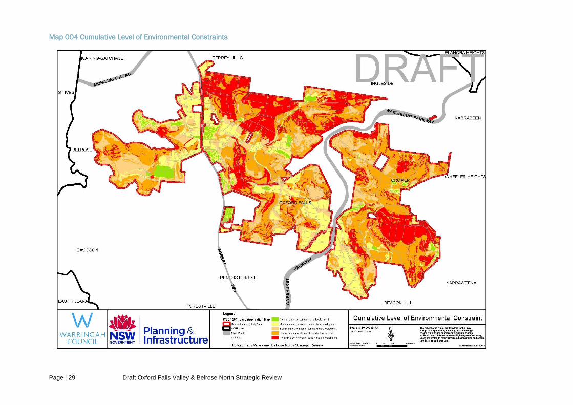
Page | 29 Draft Oxford Falls Valley & Belrose North Strategic Review
Map 004 Cumulative Level of Environmental Constraints

Page | 30 Draft Oxford Falls Valley & Belrose North Strategic Review
3.6.2 Zoning Recommendations based on the Consideration of Primary Environmental
Constraints
For the purpose of the Strategic Review, the PCG determined that areas of land with a
‘Prohibitive’ ‘Severe’ or ‘Significant’ level of environmental constraint should be zoned E3
Environmental Management as these areas have levels of environmental significance which
can be directly correlated with the objectives of the E3 Environmental Management zone.
Further, such zoning is also consistent with the desired future character for both C8 Belrose
North and B2 Oxford Falls Valley localities under the WLEP 2000.
The PCG also determined that land classified as having ‘Moderate’ or ‘No’ level of
environmental constraint should be further assessed against secondary constraints (such as
bushfire risk, heritage, infrastructure servicing, distance to services and communications
buffers etc) prior to determining an appropriate zoning for that land. This is demonstrated
with reference to the deferred areas on Map 005 shaded green or yellow. Table 3 below
illustrates a summary of the three categories with zoning recommendations.
Table 3 Summary of Results of Primary Environmental Constraints Assessment
Level of Environmental constraint to development
Recommended Zoning Map 005 identification colour
Prohibitive, severe or significant environmental constraint to development
E3 Environmental Management
Moderate environmental constraint to development
Further assessment required to determine zoning
No environmental constraint to development
Further assessment required to determine zoning

Page | 31 Draft Oxford Falls Valley & Belrose North Strategic Review
Map 005 Outcome of the Primary Environmental Constraints Analysis

Page | 32 Draft Oxford Falls Valley & Belrose North Strategic Review
3.7 Secondary Environmental Constraints, Infrastructure and Planning
Considerations
Sites marked in yellow and green on Map 005 were considered further against the following
four stages:
Stage 1: Isolated and Constrained Land
The first part examined the remaining land against the following criteria:
Whether it was isolated from urban land;
Whether it was surrounded by bushland and/or vacant land or prohibitive, severe or
significantly constrained land;
Whether the desired future character of the land was compatible with the E3
Environmental Management objectives; and
Whether the cumulative impact of rezoning the land would be significant enough to
warrant further studies to support the rezoning.
The PCG agreed that land that was affected by one or more of the above considerations
should also be zoned E3 Environmental Management because these features can be
directly correlated with the objectives of the E3 Environmental Management zone. This land
is coloured pink on Map 006.
Stage 2: Physical and Human Infrastructure Considerations
Secondly, the PCG identified land that contains existing physical and human infrastructure in
the study area such as utility undertakings and community uses (i.e. churches and
educational establishments) and existing seniors housing developments. The PCG agreed to
undertake more detailed zoning and landuse control considerations for these sites. These
sites are hatched in black on Map 006.
Stage 3: Secondary Constraints Analysis
Thirdly, similar to the process undertaken for the primary environmental constraints analysis,
a secondary analysis was undertaken which considered key planning and environmental
issues such as bushfire, heritage, infrastructure provision and distance to services. The
secondary constraints analysis is detailed in Appendix 8.
The PCG determined that land that received Category 3 rating based on the secondary
constraints analysis should also be considered for E3 Environmental Management zoning.
This land is hatched in blue on Map 006.

Page | 33 Draft Oxford Falls Valley & Belrose North Strategic Review
Stage 4: Land Identified For More Detailed Zoning Consideration
As a result of the primary and secondary constraints analysis (including stages 1 to 3
above), land marked in yellow on Map 006 was identified by the PCG for more detailed
zoning consideration, as this land is the least constrained in the study area.
The following matters were considered in more detail when determining a suitable land use
zone for this land:
Relevant planning legislation, studies, policies and guidelines;
The broader strategic context;
How and why other land was zoned to underpin LEP 2011;
Consideration of key planning issues as outlined in Section 3.5 of this report;
Existing information on environmental constraints and infrastructure provision on the
subject and surrounding land;
Whether the site adjoins an urban area and/or environmentally sensitive land;
Verification of information via site visits and consideration of stakeholder submissions
to date;
The existing and desired future character of the area;
Determination of best fit zoned and planning controls based on controls under LEP
2000.

Page | 34 Draft Oxford Falls Valley & Belrose North Strategic Review
Map 006 Outcome of the Secondary Environmental Constraints Analysis

Page | 35 Draft Oxford Falls Valley & Belrose North Strategic Review
4.0 RECOMMENDATION
4.1 Outcome of the Strategic Review
In applying the above translation methodology, the following zoning controls are
recommended and are illustrated on the Proposed Land Zoning Map (Map 007).
The proposed zoning map indicates that a large portion of land within the review area is
proposed to be zoned E3 Environmental Management with smaller areas of land
recommended for different zoning.
In summary, the key zoning recommendations are as follows:
Zone E3 Environmental Management
The E3 Environmental Management zone is proposed to apply to the majority of the review
area on land that is significantly constrained by environmental and infrastructure factors.
This also includes land that is isolated, does not adjoin urban areas and/or would
cumulatively have a significant impact if zoned to an alternative zone without first
undertaking studies recommended by the PAC.
Zone R2 Low Density Residential
The R2 Low Density zone is proposed to apply in the following locations:
Dawes Road Precinct- this land is currently subject to an advanced Planning Proposal
which commenced prior to the start of this review and proposes R2 Low Density
Residential zoning.
Seniors Housing – there are several existing seniors housing sites within the strategic
review area. Whilst it is unlikely these will be redeveloped in the near future, the
proposed R2 Low Density Residential zone acknowledges the existing use of these
sites and ensures that the current use for seniors housing is not non-conforming.
Zone R5 Large Lot Residential
The R5 Large Lot Residential zone is recommended for areas of land located on the
northern side of Wyatt Avenue and eastern side of Forest Way. This land is generally
located at the interface of environmentally sensitive land along one boundary and urban land
along the other. The recommended zoning provides a way of minimising landuse conflicts
within the zone and adjoining zones. It also supports residential housing in a rural setting
whilst preserving and minimising impacts on environmentally sensitive locations and the
scenic quality of the area.
The recommended R5 Large Lot Residential zone will ensure that future development will
not result in an unreasonable increase in the demand for public services and facilities and
can make efficient use of existing infrastructure and services prior to finalisation of a future
Warringah Housing Strategy which will determine how best to meet Warringah’s housing
targets and housing needs. In this regard, the minimum lot size restrictions that currently
apply to the land are recommended to remain unchanged. Land zoned R5 Large Lot
Residential that adjoin an urban area will be eligible to apply for a Site Compatibility
Certificate for seniors housing.

Page | 36 Draft Oxford Falls Valley & Belrose North Strategic Review
Zone RU4 Primary Production Small Lots
This zone is proposed to apply to an area of land on the western side of Forest Way
because of this land’s geographical location, existing and desired future character and the
level of environmental and infrastructure constraints which were verified during the
December 2012 site visits.
It is also recommended that a list of Schedule 1 Additional permitted Uses, similar to
Schedule 1(18) in LEP 2011 also be applied to this land in order to capture the majority of
the landuses that currently operate on the land. Map 008 annotates this as “Area 11”.
Landuses operating on this land that are not identified explicitly under Schedule 1 rely on
existing use rights.
Zone SP2 Special Purpose
The PCG agreed to apply the SP2 Infrastructure zone to all significant infrastructure land
within the study area. This includes the telecommunications facilities operated by Telstra and
Optus. This is consistent with the application of the SP2 Infrastructure zone elsewhere
under LEP 2011.
Schedule 1 Additional Permitted Uses
In addition to the proposed RU4 Primary Production Small Lots zone along the western side
of Forest Way, Belrose, this review recommends that certain land along Wakehurst
Parkway, Frenchs Forest also be included under Schedule 1 to allow development for the
purpose of a place of public worship. Map 008 annotates it as “Area 12”.This site is
proposed to be zoned E3 Environmental Management which does not permit places of
public worship. The site provides social infrastructure in the form of a large church with
ancillary landuses and it is important that the strategic review recognises the existing use.
An alternative zoning could be SP2 Place of Public Worship, however, this would be
inconsistent with how other churches are currently zoned within the LGA.
The PCG has also agreed to include Schedule 1 items that were submitted to the Minister
for Planning and Infrastructure in the Draft LEP 2011. This includes certain land at
Challenger Drive, Belrose (Area 13) which is currently used for a quarry (extractive
industries) and a small number of additional uses including recreation facilities (indoor),
recreation facilities (outdoor), processing and recycling facility for construction and
demolition waste and a concrete batching plant.
Consideration of Including Additional Planning Controls
The aim of this strategic review was to recommend planning controls that most closely
reflect existing planning controls under LEP 2000. For this reason, no additional planning
controls are proposed. In this respect, the review does not propose to modify the housing
density requirements of the B2 Oxford Falls Valley and C8 Belrose North localities of LEP
2000 which are currently included under Clause 6.6 of LEP 2011. On the contrary, Clause
6.6 will be expanded to apply to land within the study area that is proposed to be zoned E3
Environmental Management, RU4 Primary Production Small Lots and R5 Large Lot
Residential because the density control applies to both localities in their entirety under LEP
2000.

Page | 37 Draft Oxford Falls Valley & Belrose North Strategic Review
Map 007 Proposed Land Zoning Map

Page | 38 Draft Oxford Falls Valley & Belrose North Strategic Review
Map 008 Proposed Additional Permitted Uses Map

Page | 39 Draft Oxford Falls Valley & Belrose North Strategic Review
4.2 Implementing the Recommendations of the Strategic Review
Warringah Local Environmental Plan 2011
The following changes to the Warringah LEP 2011 are required to implement the
recommendations of this strategic review:
Map Changes:
1. The land Zoning Map sheets 003, 007 and 008A need to be updated to include zoning
controls for the deferred area (Map 007 in this report illustrates the recommended
zoning);
2. The Additional Permitted Use Map sheet 007 needs to be updated to include Area 11
(land west of Forest Way, Belrose North), Area 12 (land at Wakehurst Parkway, Frenchs
Forest) and Area 13 (land at Challenger Drive, Belrose). Please refer to Map 008 in this
report which identifies these areas.
3. All other relevant LEP map layers that cover the deferred land need to be brought into
LEP 2011.
Standard Instrument changes:
1. Land Use Table – amend the Land Use table to insert a new zone: R5 Large Lot
Residential:
R5 Large Lot residential
1 Objectives of Zone
To provide residential housing in a rural setting while preserving, and minimising impacts on, environmentally sensitive locations and scenic quality.
To ensure that large residential lots do not hinder the proper and orderly development of urban areas in the future.
To ensure that development in the area does not unreasonably increase the demand for public services or public facilities.
To minimise conflict between land uses within this zone and land uses within adjoining zones.
To ensure that development, by way of its character, design, location and materials of construction, is integrated into the site and natural surroundings, complements and enhances the natural environment and has minimal visual impact.
To protect and enhance the natural landscape by conserving remnant bushland and
rock outcrops and by encouraging the spread of an indigenous tree canopy.
To protect and enhance visual quality by promoting dense bushland buffers adjacent
to major traffic thoroughfares.

Page | 40 Draft Oxford Falls Valley & Belrose North Strategic Review
2 Permitted Without Consent
Home-based child care; Home occupations
3 Permitted With Consent
Aquaculture; Bed and breakfast accommodation; Building identification signs; Business
identification signs; Community facilities; Dwelling houses; Emergency services
facilities; Environmental facilities; Environmental protection works; Extensive agriculture;
Farm buildings; Home businesses; Home industries; Horticulture; Recreation areas;
Roads
4 Prohibited development
Any development not specified in item 2 or 3
2. Clause 6.6 Erection of Dwelling Houses in the Zone E3 Environmental Management –
this clause needs to be amended so that it applies to all land within the study area
including land zoned E3 Environmental Management, RU4 Primary Production Small
Lots and R5 Large Lot Residential.
3. Schedule 1 Additional Permitted Uses –
A. Amend Item 18 to include land on the western side of Forest Way, Belrose, as
follows:
18 Use of certain land in the vicinity of Mona Vale and Myoora Roads, Terrey Hills
and certain land to the western side of Forest Way, Belrose.
(1) This clause applies to land in the vicinity of Mona Vale and Myoora Roads, Terrey
Hills, shown as “Area 1” on the Additional Permitted Uses Map and certain
land to the western side of Forest Way, Belrose, shown as "Area 11" on
the Additional Permitted Uses Map.
(2) Development for the purposes of educational establishments, garden centres,
hospitals, hotel or motel accommodation, places of public worship, recreation
areas, recreation facilities (indoor), recreation facilities (outdoor), registered
clubs and restaurants or cafes is permitted with consent.
B. Add the following items:
19 Use of certain land at Wakehurst Parkway, Frenchs Forest.
(1) This clause applies to at Wakehurst Parkway, Frenchs Forest, being Lot
1, DP 863123 shown as “Area 12" on the Additional Permitted Uses
Map.
(2) Development for the purposes of places of public worship is permitted
with consent.

Page | 41 Draft Oxford Falls Valley & Belrose North Strategic Review
20 Use of certain land at Challenger Drive, Belrose.
(1) This clause applies to so much of the land at Challenger Drive, Belrose,
shown as “Area 13" on the Additional Permitted Uses Map, that is
covered by Lease RE 412 592 (issued by the Department of Lands).State
Environmental Planning Policies.
(2) Development for the purposes of extractive industries, recreation
facilities (indoor), recreation facilities (outdoor), processing and
recycling facility for construction and demolition waste and a concrete
batching plant is permitted with consent.
SEPPs which make reference to Warringah LEP 2000 or specifically localities B2 Oxford
Falls Valley and C8 Belrose North need to be amended.
Section 117 Directions
Any future Planning Proposal will need to demonstrate consistency with Section 117
Directions. Section 117 of the EP&A Act enables the Director General of NSW Department
of Planning and Infrastructure to issue directions regarding the content of LEPs to the extent
that they must achieve or give effect to particular principles, aims, objectives or policies set
out in those directions.
A review of relevant S117 Directions (Appendix 9) has determined that the
recommendations of the Strategic Review (which will underpin a planning proposal to amend
WLEP2011) are consistent with all relevant Section 117 Directions.

Page | 42 Draft Oxford Falls Valley & Belrose North Strategic Review
5.0 NEXT STEPS
It is recommended that this report is placed on public exhibition. This will provide the
community with an opportunity to raise key issues regarding the proposed zoning controls by
making a submission during the public exhibition period.
The PCG will prepare a submissions report and submit it together with a revised draft
strategic review report which responds to submissions, to the Warringah Development and
Assessment Panel (WDAP). This will provide a final opportunity for the community to raise
any issues it may have about the outcomes of the draft review. Following the hearing, the
Panel will provide an independent assessment recommendations report to the Council for
consideration.
Once these steps are undertaken, it is recommended that the final outcome of this report
underpins a Planning Proposal to incorporate the proposed zoning controls into Warringah
LEP 2011.
The PAC recommended that the stage 2 review commence within 5 years of its
recommendation in 2009. It is anticipated that stage 2 review will commence shortly and that
there may be an overlap between Stage 1 being finalised and Stage 2 commencing. Whilst
the PAC report examined 4 key precincts within the study area, its recommendation was that
key studies be undertaken to cover the broader Oxford Falls catchment. Defining this area
will be an early task of stage 2 of the future review.

Page | 43 Draft Oxford Falls Valley & Belrose North Strategic Review
References
Atlas of NSW Wildlife (the Atlas), Office of Environment and Heritage's (OEH's) database of flora and
fauna records.
Draft North-East Subregional Strategy, City of Cities a Plan for Sydney’s Future, NSW Department of
Planning and Infrastructure, 2007.
Environmental Planning and Assessment Act, 1979.
Environmental Planning and Assessment Regulations, 2000.
Living Warringah, How we will live, work and play in the next decade and beyond, Warringah Council,
2005.
LEP Practice Note PN09-002 Environment Protection Zones, Department of Planning and
Infrastructure, 2009.
LEP Practice Note PN11-002 Preparing LEPs using the Standard Instrument: standard zones,
Department of Planning and Infrastructure, 2011.
Middle Creek Flood Study, prepared by Worley Parsons for Warringah Council, 2009.
NSW 2021: A plan to make NSW number one sets the Government's agenda for change in NSW,
NSW Department of Planning and Infrastructure, 2012.
Metropolitan Plan for Sydney 2036, NSW Department of Planning and Infrastructure, 2010.
Review of Four Sites Within Oxford Falls Valley for Urban Development, NSW Planning Assessment
Commission, 2009.
State Environmental Planning Policy No.71 – Coastal Projection.
State Environmental Planning Policy (Exempt and Complying Development Codes) 2008.
State Environmental Planning Policy (Housing for Seniors of People with a Disability) 2004.
State Environmental Planning Policy (Infrastructure) 2007.
State Environmental Planning Policy (Mining, Petroleum Production and Extractive Industries) 2007.
State Environmental Planning Policy 30 – Intensive Agriculture
Standard Instrument (Local Environmental Plans) Order 2006.
Threatened Species Conservation Act, 1995
Warringah Creek Management Study, Warringah Council, 2004.
Warringah Development Control Plan
Warringah Local Environmental Plan 2000.
Warringah Local Environmental Plan 2011.
Warringah Natural Area Survey, Warringah Council, 2005.
Warringah Natural Area Survey: Vegetation History and Wildlife Corridors Update 2009 prepared by P
and J Smith Ecological Consultants for Warringah Council.

Page | 44 Draft Oxford Falls Valley & Belrose North Strategic Review
Warringah Strategic Community Plan, Warringah Council, 2012.
Oxford Falls Valley and Belrose North Strategic Review, Community Information Evening - Outcomes
Report, prepared by Straight Talk on behalf of the NSW Department of Planning and Infrastructure
and Warringah Council, 2011.
Warringah Council Planning Report, Oxford Falls Valley – Assessment of Rezoning / Development
Proposals.

Page | 45 Draft Oxford Falls Valley & Belrose North Strategic Review
Appendix 1
Extract from the EP&A Act 1979 and Regulations on Existing Use Rights
Environmental Planning and Assessment Act 1979
Division 10 Existing uses
106 Definition of “existing use”
In this Division, existing use means:
(a) the use of a building, work or land for a lawful purpose immediately before the coming into force of
an environmental planning instrument which would, but for Division 4 of this Part, have the effect of
prohibiting that use, and
(b) the use of a building, work or land:
(i) for which development consent was granted before the commencement of a provision of
an environmental planning instrument having the effect of prohibiting the use, and
(ii) that has been carried out, within one year after the date on which that provision
commenced, in accordance with the terms of the consent and to such an extent as to ensure
(apart from that provision) that the development consent would not lapse.
107 Continuance of and limitations on existing use
(1) Except where expressly provided in this Act, nothing in this Act or an environmental planning
instrument prevents the continuance of an existing use.
(2) Nothing in subsection (1) authorises:
(a) any alteration or extension to or rebuilding of a building or work, or
(b) any increase in the area of the use made of a building, work or land from the area actually
physically and lawfully used immediately before the coming into operation of the instrument therein
mentioned, or
(c) without affecting paragraph (a) or (b), any enlargement or expansion or intensification of an
existing use, or
(d) the continuance of the use therein mentioned in breach of any consent in force under this Act in
relation to that use or any condition imposed or applicable to that consent or in breach of any
condition referred to in section 80A (1) (b), or
(e) the continuance of the use therein mentioned where that use is abandoned.
(3) Without limiting the generality of subsection (2) (e), a use is to be presumed, unless the contrary
is established, to be abandoned if it ceases to be actually so used for a continuous period of 12
months.

Page | 46 Draft Oxford Falls Valley & Belrose North Strategic Review
108 Regulations respecting existing use
(1) The regulations may make provision for or with respect to existing use and, in particular, for or
with respect to:
(a) the carrying out of alterations or extensions to or the rebuilding of a building or work being used
for an existing use, and
(b) the change of an existing use to another use, and
(c) the enlargement or expansion or intensification of an existing use.
(d) (Repealed)
(2) The provisions (in this section referred to as the incorporated provisions) of any regulations in
force for the purposes of subsection (1) are taken to be incorporated in every environmental planning
instrument.
(3) An environmental planning instrument may, in accordance with this Act, contain provisions
extending, expanding or supplementing the incorporated provisions, but any provisions (other than
incorporated provisions) in such an instrument that, but for this subsection, would derogate or have
the effect of derogating from the incorporated provisions have no force or effect while the incorporated
provisions remain in force.
(4) Any right or authority granted by the incorporated provisions or any provisions of an
environmental planning instrument extending, expanding or supplementing the incorporated
provisions do not apply to or in respect of an existing use which commenced pursuant to a consent of
the Minister under section 89 to a development application for consent to carry out prohibited
development.
Environmental Planning and Assessment Regulations 2000
Part 5 Existing uses
41 Certain development allowed
(cf clause 39 of EP&A Regulation 1994)
(1) An existing use may, subject to this Division:
(a) be enlarged, expanded or intensified, or
(b) be altered or extended, or
(c) be rebuilt, or
(d) be changed to another use, but only if that other use is a use that may be carried out with or
without development consent under the Act, or
(e) if it is a commercial use—be changed to another commercial use (including a commercial use that
would otherwise be prohibited under the Act), or
(f) if it is a light industrial use—be changed to another light industrial use or a commercial use
(including a light industrial use or commercial use that would otherwise be prohibited under the Act).
(2) However, an existing use must not be changed under subclause (1) (e) or (f) unless that change:
(a) involves only alterations or additions that are minor in nature, and

Page | 47 Draft Oxford Falls Valley & Belrose North Strategic Review
(b) does not involve an increase of more than 10% in the floor space of the premises associated with
the existing use, and
(c) does not involve the rebuilding of the premises associated with the existing use, and
(d) does not involve a significant intensification of that existing use.
(e) (Repealed)
(3) In this clause:
commercial use means the use of a building, work or land for the purpose of office premises,
business premises or retail premises (as those terms are defined in the Standard Instrument (Local
Environmental Plans) Order 2006).
light industrial use means the use of a building, work or land for the purpose of light industry (within
the meaning of the Standard Instrument (Local Environmental Plans) Order 2006).
42 Development consent required for enlargement, expansion and intensification of existing
uses
(cf clause 40 of EP&A Regulation 1994)
(1) Development consent is required for any enlargement, expansion or intensification of an existing
use.
(2) The enlargement, expansion or intensification:
(a) must be for the existing use and for no other use, and
(b) must be carried out only on the land on which the existing use was carried out immediately before
the relevant date.
43 Development consent required for alteration or extension of buildings and works
(cf clause 41 of EP&A Regulation 1994)
(1) Development consent is required for any alteration or extension of a building or work used for an
existing use.
(2) The alteration or extension:
(a) must be for the existing use of the building or work and for no other use, and
(b) must be erected or carried out only on the land on which the building or work was erected or
carried out immediately before the relevant date.
44 Development consent required for rebuilding of buildings and works
(cf clause 42 of EP&A Regulation 1994)
(1) Development consent is required for any rebuilding of a building or work used for an existing use.
(2) The rebuilding:
(a) must be for the existing use of the building or work and for no other use, and

Page | 48 Draft Oxford Falls Valley & Belrose North Strategic Review
(b) must be carried out only on the land on which the building or work was erected or carried out
immediately before the relevant date.
45 Development consent required for changes of existing uses
(cf clause 43 of EP&A Regulation 1994)
Development consent is required:
(a) for any change of an existing use to another use, and
(b) in the case of a building, work or land that is used for different existing uses, for any change in the
proportions in which the various parts of the building, work or land are used for those purposes.
46 Uses may be changed at the same time as they are altered, extended, enlarged or rebuilt
(cf clause 44 of EP&A Regulation 1994)
Nothing in this Part prevents the granting of a development consent referred to in clause 42, 43 or 44
at the same time as the granting of a development consent referred to in clause 45.
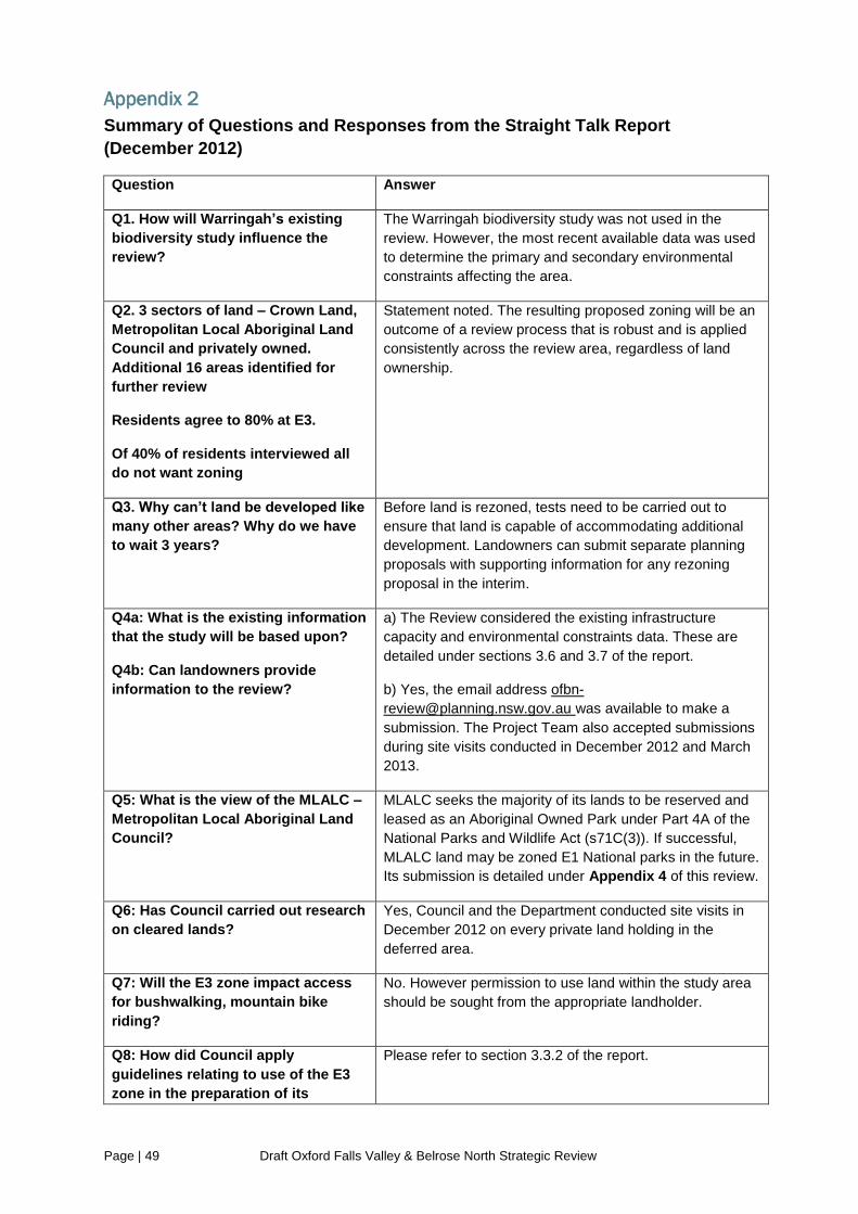
Page | 49 Draft Oxford Falls Valley & Belrose North Strategic Review
Appendix 2
Summary of Questions and Responses from the Straight Talk Report
(December 2012)
Question Answer
Q1. How will Warringah’s existing
biodiversity study influence the
review?
The Warringah biodiversity study was not used in the
review. However, the most recent available data was used
to determine the primary and secondary environmental
constraints affecting the area.
Q2. 3 sectors of land – Crown Land,
Metropolitan Local Aboriginal Land
Council and privately owned.
Additional 16 areas identified for
further review
Residents agree to 80% at E3.
Of 40% of residents interviewed all
do not want zoning
Statement noted. The resulting proposed zoning will be an
outcome of a review process that is robust and is applied
consistently across the review area, regardless of land
ownership.
Q3. Why can’t land be developed like
many other areas? Why do we have
to wait 3 years?
Before land is rezoned, tests need to be carried out to
ensure that land is capable of accommodating additional
development. Landowners can submit separate planning
proposals with supporting information for any rezoning
proposal in the interim.
Q4a: What is the existing information
that the study will be based upon?
Q4b: Can landowners provide
information to the review?
a) The Review considered the existing infrastructure
capacity and environmental constraints data. These are
detailed under sections 3.6 and 3.7 of the report.
b) Yes, the email address ofbn-
[email protected] was available to make a
submission. The Project Team also accepted submissions
during site visits conducted in December 2012 and March
2013.
Q5: What is the view of the MLALC –
Metropolitan Local Aboriginal Land
Council?
MLALC seeks the majority of its lands to be reserved and
leased as an Aboriginal Owned Park under Part 4A of the
National Parks and Wildlife Act (s71C(3)). If successful,
MLALC land may be zoned E1 National parks in the future.
Its submission is detailed under Appendix 4 of this review.
Q6: Has Council carried out research
on cleared lands?
Yes, Council and the Department conducted site visits in
December 2012 on every private land holding in the
deferred area.
Q7: Will the E3 zone impact access
for bushwalking, mountain bike
riding?
No. However permission to use land within the study area
should be sought from the appropriate landholder.
Q8: How did Council apply
guidelines relating to use of the E3
zone in the preparation of its
Please refer to section 3.3.2 of the report.

Page | 50 Draft Oxford Falls Valley & Belrose North Strategic Review
LEP2011?
Q9: How will the interface between
the cleared, uncleared and semi-
cleared land be addressed?
The review involved a site visit of each landholding which
assisted in determining which land and the extent of
clearing within the review area. The detailed translation
methodology adopted for this review considers this further
and importantly highlights that an important zoning
consideration is the desired future character of the land. In
addition, a summary of each relevant zone was considered
particularly in relation to how and where each zone should
be applied as some zones are more suitable for the
interface locations.
Q10: How will this process take into
account the social and employment
impact for outdoor activities carried
out in the area?
This review involved identifying planning controls that most
closely reflect existing planning controls. Existing use
rights will continue to apply to non conforming uses.
Q11: What is happening to prevent
development creeping into the area?
This review involves indentifying planning controls that
most closely reflect existing planning controls without
adding significant additional development potential.
Q12: What is the status of land in
Kimbriki Rd with regards to being
included in the review?
The land in Kimbriki Road is not included in this review
because the land is not deferred from LEP 2011.
Q13: In planning future
developments will everyone get a
say?
Yes, anyone was able to make a submission to the
designated Oxford Falls Valley & Belrose North Strategic
Review email address, [email protected].
Additional input opportunities will be available as detailed
under section 3.4 of this report.
Q14: 80% of the land should be
retained as E3. Any exiting
developments should not be E3 – we
pay a lot of fees/rates and just want
to be left alone.
Statement noted.
Q15a: Live on the edge of the land –
bushwalker. Got a letter in letter box
– directed me to the website – wasn’t
useful. At weekend thousands of
people come – there weren’t made
aware of this. Understand what all
stakeholders want.
Q15b: Use paper
Statement noted. The Department and Warringah Council
kept the community informed on the strategic review by
regularly updating the Department’s and Council’s
websites and providing updates on consultation events
through the Manly Daily. Additionally, a dedicated email
address was created for the public to make submissions
during the review.
Consultation will continue as detailed under section 3.4 of
this report.
Q16: I don’t envy your task. Could
there be an integrated solution to
offer tax relief to landowners by
declaring land for conservation?
Tax relief is outside the scope of this review.
Q17: How does the land get zoned
when it is cleared and adjoining
Proposed zoning is based on the level of primary and
secondary constraints affecting the site and several other
considerations outlined under section 4 of this report.

Page | 51 Draft Oxford Falls Valley & Belrose North Strategic Review
existing residential development? Cleared land does not automatically indicate that E3
Environmental Management Zoning is inappropriate and
matters such as desired future character, whether the land
is in an interface location, isolated from an urban area etc
are considered.
Q18: Is E3 the only option? What
development is allowed in the E3
zoning?
The Review involved considering all relevant zones and
did not have preconceived ideas on the ‘right’ zoning. The
review method was applied consistently across the study
area.
Refer to Table 1 of this report which outlines development
that is permissible in the E3 Environmental Management
zone.
Q19: Has anyone asked the MLALC
about their views?
Yes, the MLALC has made a submission which has been
considered as part of this review report.
Q20: What are the social situations
that are being taken into account?
C3 Church – defined as a public
place of worship but offer other
services, bible school, kids play
centre, debt counselling service
The Review involved indentifying planning controls that
most closely reflect existing planning controls. Ancillary
uses that operate incidentally to the main use can continue
to do so and the review will not affect that.
Q21: Can locality B9 (Kimbriki ) be
included in the review? Why is the
zero involvement when rezone land?
The land in Kimbriki Road was not included in this review
because the land is not deferred.
Q22: What is the engagement
process for stakeholders who may
not live in the area? 40000 ride in the
area – rep of North Beaches
Mountain Bike.
Section 3.4 of this report outlines the level of consultation
undertaken and future opportunities.
Q23: Will the review give equal
weight to the Middle Harbour and
Narrabeen lagoon catchment areas?
Yes
Q24: Can the E2 Environmental
Conservation zone be used? 27
communities of threatened species
Yes, all zones have been considered when undertaking
the review.
Q25a: What spectrum of
development do landowners want?
Q25b: Will we be able to do what
they can now under new zoning?
The Review involves indentifying planning controls that
most closely reflect existing planning controls.
Q26: Mountain bikers can go out and
use their land. I just want assurance
that I can use my land how I want to
use it.
Statement noted. It is up to the private landowner to
determine level of access to their land and is not an issue
that can be addressed through this review. The
permissibility of landuses will be determined by the
proposed zoning.
Q27: We are being asked to endorse
an administration process rather
Statement noted. This Review involved identifying planning
controls that most closely reflect existing planning controls.

Page | 52 Draft Oxford Falls Valley & Belrose North Strategic Review
than consider the heterogeneous
area involved.
The Review has been conducted in a transparent and
open manner by which anyone can make a submission to
the review.
Q28a: Does Council have a
population policy?
Q28b: Higher targets? Where are
they going to park?
a) Under the draft North East Subregional Strategy, the
Warringah LGA has a dwelling target of 10,300 new
homes by 2031.
b) A future Warringah Housing Strategy will determine how
best to accommodate this target.
Q29: Does Council have an intention
to buy land to turn into a National
Park?
No. This is outside the remit of this review.
Q30: Where does the assumption
that additional houses are good for
the area?
The Review involves identifying planning controls that
most closely reflect existing planning controls and does not
examine the future urban development potential of the
area.
Q31a: How are the individual parcels
of land going to be assessed?
Q31b: Will we be notified?
a) Individual site visits were conducted to determine what
land use was currently operating on each site. Detailed
methodology in Section 3 of this report.
b) Yes, a letter was sent detailing the time and date of
inspections.
Q32: In the cases that Category 1 or
Category 2 do not translate to the
new land use zones, is there going to
be compensation for land owners
who claim their land is down zoned?
No.
Q33: When is Council going to plan
for adequate transport in and out of
the area?
The Review involves identifying planning controls that
most closely reflect existing planning controls. Transport
planning is not within the remit of this review.
Q34a: Does the E3 zoning freeze
development of land?
Q34b: Are the Category 2 uses that
are compatible with the desired
future character permissible in the
LEP2011?
Q34c: Is the E2 zone being
considered?
a) No, existing use rights apply and a number of land uses
are permissible with consent (refer to section 3.3.4 of this
report).
b) The Review involves identifying planning controls that
most closely reflect existing planning controls.
c) Yes, all zones were considered in the review process.
Q35: How will existing uses be
treated when applications are lodged
for alterations and additions?
Existing use rights continue to apply and will be assessed
in accordance with the legislation. Please refer to section
3.3.4 of this report for further details.
Q36: Is it possible for the process to
identify the longer term future for the
land? Bushland will be have
significantly more value in the future.
The review involves indentifying planning controls in LEP
2011 that most closely reflect existing planning controls
under LEP 2000 including the desired future character
statements of LEP 2000.
The second phase of the review will examine whether
some areas within the Oxford Falls Valley catchment area

Page | 53 Draft Oxford Falls Valley & Belrose North Strategic Review
are suitable for future urban growth.
Q37: Are spot rezoning where
services are available able to be
done?
This review did not examine additional development
potential. However this review does not prevent individual
landowners pursuing spot rezonings.
Q38: Want controlled development.
Want to give a block of land to
children. Doesn’t need to massive
scale.
Statement noted.
The Review involves indentifying planning controls that
most closely reflect existing planning controls. The stage 2
of the review will examine whether some areas of non-
urban land are suitable of for future urban growth.
Q39: What is the definition of senior
housing?
seniors housing is defined under the Warringah LEP
2011 as a building or place that is:
(a) a residential care facility (b) a hostel within the meaning of clause 12 of SEPP
(Housing for Seniors or People with a Disability) 2004, or
(c) a group of self contained dwellings, or (d) a combination of any of the buildings or places
referred to in paragraphs (a)-(c), and that is, or is intended to be, used permanently for:
(e) seniors or people who have a disability, or (f) people who live in the same household with
seniors or people who have a disability, or (g) staff employed to assist in the administration of the
building or place in the provision of services to persons living in the building or place, but does not include a hospital.
Q40: Environmental protection.
National Parks have been eroded.
Don’t just speak to mountain bike
riders. Speak to bush walkers.
Statement noted. The Review involves identifying planning
controls that most closely reflect existing planning controls.

Page | 54 Draft Oxford Falls Valley & Belrose North Strategic Review
Appendix 3
Letter to Landowners
Appendix 4
Site Visit package

Page | 55 Draft Oxford Falls Valley & Belrose North Strategic Review

Page | 56 Draft Oxford Falls Valley & Belrose North Strategic Review

Page | 57 Draft Oxford Falls Valley & Belrose North Strategic Review
Appendix 5
Submissions

Page | 58 Draft Oxford Falls Valley & Belrose North Strategic Review
Uniting Care Ageing
Issue: Seek R3 Medium Residential Density zoning for its site at 2B Morgan Road, Belrose
because this zone is the only residential zone which will permit the existing uses on
premises.
Response: Applying the R3 Medium Density zoning in this location is inappropriate
because:
It would not be the best fit translation;
The range of uses this zoning would permit is inconsistent with the locality statement
and the desired future character of the area; and
It is inconsistent with the methodology applied by Warringah Council in selecting land
suitable for medium density zoning under Warringah LEP 2011. The R3 Medium
Density Zoning applies in areas adjoining or within a centre with established local
services and infrastructure. The R2 Low Density Residential zone combined with the
application of the State Environmental Planning Policy (Seniors Housing) will
continue to permit the uses currently operating on this site.
Metropolitan Local Aboriginal Land Council (MLALC)
Issue: The MLALC has requested that the Project Team acknowledges that MLALC seeks
for a large part of its lands in the study area to be reserved and leased as an Aboriginal
Owned Park under Part 4A (section 71C(3)) of the National Parks and Wildlife Act because
of the lands’ cultural and natural significance to Aboriginal people.
MLALC has also requested that 6 of its lots be excluded from the application under Part 4A
and is opposed to these properties being zoned E3 Environmental Management.
During a site visit with MLALC representatives, the review team was advised that a Planning
Proposal will be submitted shortly for a portion of its land within the review area to comprise
approximately 167 residential lots.
MLALC subsequently requested that all its landholdings within the review area be deferred
to facilitate a discussion with the State Government on declaring those lands as National
Park.
Response: The Review Team notes MLALC’s intention for a large portion of its extensive
landholdings within the study area to be reserved and leased as an Aboriginal Owned Park
(National Park). Should MLALC be successful in having this land proclaimed an Aboriginal
Owned Park (National Park), a separate planning proposal application will be required to
rezone that land to E1 National Parks. In the interim, it is not considered appropriate to defer
these lands.
In relation to the potential Planning Proposal, this will be considered by Warringah Council
when it is formally lodged.
Sisters of the Good Samaritan
Issue: Seek R2 Low Density Residential zoning for its land at Perentie Road, Oxford Falls
and have aspirations to develop for low density residential development.

Page | 59 Draft Oxford Falls Valley & Belrose North Strategic Review
Response: On the basis that the strategic review is a translation process that does not
examine additional development opportunities, this land as well as all other land within the
study area has been considered against primary and secondary environmental constraints.
The primary environmental constraints analysis identified that the subject landholdings are
affected by a combination of prohibitive and severe level of environmental constraints. In
applying the PCG’s position to zone all land that contains a prohibitive, severe or significant
level of environmental constraints to E3 Environmental Management, this land holding is
proposed to be zoned E3 Environmental Management at this stage.
Warringah Urban Fringe Association Incorporated (WUFA)
Issue: WUFA’s submission proposes a range of zoning options for the 150 landowners it
represents including RU4 Primary Production Small Lots, R5 Large Lot Residential, R2 Low
Density Residential and R3 Medium Density Residential. In addition, WUFA highlights that
the translation to E3 Environmental Management zoning would not permit housing for older
people and people with disabilities which is a category 2 landuse under Warringah LEP
2000. WUFA also queries the accuracy of Council’s Biodiversity study, riparian land policy,
bush fire prone land map and environmental constraints mapping in general. It also
requested that site visits be carried out as part of this strategic review.
Response: The strategic review considered the suitable zoning for each lot within the review
area. This involved undertaking individual site visits (ground truthing), consistently applying
the primary and secondary constraints methodology and the translation methodology. The
review process and methodology, including details on the environmental data and studies
used in the analysis is outlined in detail under section 4 of this report and associated
Appendices.
It is important to highlight that the purpose of this strategic review was to recommend
planning controls that most closely reflect existing planning controls and that no
recommendations are made on whether certain areas are appropriate for urban growth. This
will form part of stage two of the review.
Whilst the outcome of this review clearly demonstrates that it is appropriate to zone the
majority of the land within the review area to E3 Environmental Management, there are
some small areas of land where it was considered more suitable to apply a different zone.
This is discussed in further detail under section 4.1 of this report. In relation to the
permissibility of seniors housing, this is addressed under section 3.5 of this report.
Catholic Archdiocese of Sydney
Issue: The Archdiocese has aspirations to develop part of its land for low density residential
development (adjoining existing R2 Low Density Residential land) and offset a significant
portion of its landholdings for bushland. Following a site meeting, the Archdiocese submitted
its original submission on the Warringah LEP 2011 to be considered as part of this review.
Response: On the basis that the strategic review is a translation process that does not
examine additional development opportunities, the methodology agreed to by the PCG was
applied to consider the zoning for this site. The review identified that this site has significant
environmental constraints under the primary environmental constraints analysis and for this
reason is proposed to be zoned E3 Environmental Management.
OPTUS

Page | 60 Draft Oxford Falls Valley & Belrose North Strategic Review
Issue: OPTUS has requested a development buffer for non residential uses of 250 metres
from its facilities and to exclude high voltage wielding machinery and motor sports activities
within 500 metres of each earth station. OPTUS recommended that specific local provisions
are included in the LEP to address this issue.
Response: The Strategic Review has not identified any non domestic facilities within 250
metres of the earth stations in the review area. In addition the primary and secondary
environmental constraints analysis has identified that land within 250 metres of the earth
stations contains significant environmental constraints and is proposed to be zoned E3
Environmental Management. The proposed E3 Environmental Management zone does not
permit industrial operations. The development application process will identify any
undesirable uses from intensifying within the 500 metre radius. Therefore it is unnecessary
for specific provisions on this matter to be included in the Warringah LEP 2011.
Friends of the Narrabeen Lagoon Catchment
Issue: Friends of Narrabeen Lagoon Catchment are of the opinion that the review project
should achieve;
- standard zone based on an accurate translation of the ‘desired future character’;
- environment protection as a key land use objective;
- a translation that does not result in the rezoning of land.
Response: The review process involved undertaking individual site visits (ground truthing),
consistently applying the primary and secondary environmental constrains methodology and
considering locality statements which outlined the desired future character of the land.
The outcome of this strategic review illustrates that a significant portion of the land in the
deferred area is proposed to be zoned E3 Environmental Management, acknowledging the
natural and scenic qualities of the area. The review also revealed that there are some small
areas where zoning other than E3 Environmental Management is more appropriate.
Belrose Rural Community Association
Issue: The Belrose Rural Community Association is concerned about the loss of native
bushland that might result from this review. It requests that the ‘Desired Future Character
Statements’ of B2 and C8 localities and the requirement for a landscaped open space are
considered as part of this strategic review. In addition, the Belrose Rural Community
Association are concerned about the review process and would like to discuss the process
to have a better understanding of the process enabling them to make informed and
appropriate submissions.
Response: This review considered the desired future character statements as part of the
translation process. In relation to the concerns about the review process, the project team
facilitated a Public Information session in October 2012 which was widely advertised and
attended by local residents and landowners. A commitment was made during the information
session that the project team would undertake site visits of all land within the review area.
Landowners were notified by letter of the December 2012 site visits. There will also be future
opportunities to engage the community as part of this review which is detailed under section
3.4 of this report.
The Falls Retreat

Page | 61 Draft Oxford Falls Valley & Belrose North Strategic Review
Issue: The Falls Retreat are concerned that future zoning could affect the site functioning as
a recreational centre, function centre & short term accommodation.
Response: Existing use rights continue to apply regardless of the proposed zoning. This is
addressed under section 3.3.3 of this report.
Other Submissions
The remaining submissions raised a range of issues which are summarised below. These
represent the views of local residents, business owners and operators who wrote to the
Department whilst this review was undertaken.
Issue 1: Nine submissions seek the land in the deferred area to be preserved for its
recreational, ecological and aesthetic values.
Response: The outcome of this strategic review illustrates that a significant portion of the
land in the deferred area is proposed to be zoned E3 Environmental Management,
acknowledging its aesthetic, ecological, scientific and cultural values.
Issue 2: Seven proforma letters request their land be zoned R2 Low Density Residential, R3
Medium Density residential, RU5 Village or R5 Large Lot Residential because their land is
cleared, has good access to roads, public transport, town water and is relatively flat.
Response: The strategic review considered the appropriateness of an alternative zoning for
land within the study area. This involved undertaking site visits (ground truthing), consistently
applying the primary and secondary environmental constraints analysis and the translation
methodology. This included for example, the consideration of environmental constraints and
infrastructure provisions.
The review has identified some areas where it is considered more suitable to apply a zone
other than E3 Environmental Management. This is discussed in further detail under section
4.1 of this report.
Issue 3: Two submissions are against E3 Environmental Management zoning of their land
because their sites are capable of accommodating more that one dwelling.
Response: See response to Issue 2.
Issue 4: Seek B4 Mixed Use of B6 Enterprise Corridor zoning for land in Linden Avenue,
Belrose.
Response: See response to Issue 2.
Issue 5: E3 Environmental Management zoning will devalue land and Council will be able to
purchase land at a lower cost.
Response: Council does not have specific plans to purchase land within the review area.
Whilst value of land is not a planning consideration, the aim of the strategic review is to
adopt planning controls that most closely reflect existing planning controls under LEP 2000.
It is acknowledged that a like for like translation may not be possible in all instances.
However, the methodology used in the review process to identify a suitable zone for each
parcel of land has been applied consistently.

Page | 62 Draft Oxford Falls Valley & Belrose North Strategic Review
Issue 6: Residents in the surrounding neighbourhoods need to be included as stakeholders
in this review. Seeks a transparent review process and a consistent approach to preparing
the LEP.
Response: This report will be publicly exhibited and will be made available for viewing
through the Department’s and Council’s websites to ensure that the wider community is
involved in the review process. As mentioned previously, a methodology for the review was
established and agreed to by the PCG which was consistently applied to land within the
review area. A section of the Department’s website was designated specifically to this review
where updates on the status of the review and background information were posted and will
continue until the review is finalised.
Issue 7: Land on Northcott Road should be zoned RU4 Rural Small Holdings and seek
permissibility of uses currently available including a granny flat.
Response: Please refer to the response to issue 2. In addition, existing granny flats can
continue to operate and be extended through existing use rights if they comply with Council’s
controls on such uses.
Issue 8: Seek Residential zoning for Willandra Road, Narraweena because applying the E3
Environmental Management zone would be a downzoning.
Response: The review involved identifying planning controls for all land in the study area
that most closely reflects existing planning controls. Applying the E3 Environmental
Management zone may on face value be perceived as a downzoning because the SEPP
(Housing for Seniors or People with a Disability) 2007 does not apply to land zoned for
environmental protection whilst seniors housing is a Category 2 landuse on land adjoining
land uses for urban purposes under LEP2000. However, importantly, Category 2 landuses
need to be considered against locality statements and may not be suitable in all locations
and instances. Locality statements as well as all matters under primary and secondary
constraints were considered in identifying a suitable zone under this review. Section 3.5 of
this report provides further detail on this issue.
Issue 9: Seek medium density residential zoning in Dawes Road which will assist Warringah
Council to achieve its dwelling target set by the Department of Planning and Infrastructure.
Previous impediment to zoning this land in 2000 to residential was lack of servicing by sewer
which has now been installed.
Response: This area is subject to a planning proposal that supports an R2 Low Density
Residential zone for this area and is at an advanced stage of preparation. The PCG supports
the recommendations of the Planning Proposal.
Issue 10: Two submissions are concerned that the E3 Environmental Management zone
does not allow for improvements to home and impacts on the financial value of the land.
Response: Please refer to the response to Issue 2. In addition, the E3 Environmental
Management Zone allows for a range of uses and dwelling houses (including alterations and
additions are permissible with consent). Value of land is not a planning consideration.
Issue 11: E3 Environmental Management zone would be a downzoning for land in
Bundaleer Street, Belrose which is surrounded by schools, adjoins a main road and a
residential area. Appropriate zoning would be for residential or enterprise corridor zoning.

Page | 63 Draft Oxford Falls Valley & Belrose North Strategic Review
Response: See response to Issue 2.
Issue 12: Land at Waldon Road, Belrose should be considered for spot rezoning because
the land is cleared, adjoins a large school, residential and commercial lots and is within 100
metres of Forestway which contains transport services and infrastructure.
Response: See response to Issue 2.
Issue 13: Two submissions relating to land in Northcott Avenue seeking RU4 Primary
Production Small Lots zoning in one submission and R2 Low Density residential or R5 Large
Lot Residential in the second submission to facilitate expanding Sydney on land that adjoins
residential development, is partially cleared, has access to public transport, utilities and does
not contain endangered species.
Response: See response to Issue 2.
Issue 14: Concerned about the minimum lot size for a dwelling under the E3 Environmental
Management zone, particularly as it relates to land along Wyatt Avenue. Seek R2 Low
Density Residential or R5 Large Lot Residential zoning to rectify this or for all existing lots to
be entitled to one dwelling.
Response: See response to Issue 2. In addition, please refer to section 3.5 of this report.
Issue 15: Seek high density zoning of land within the triangle bounded by Wakehurst
Parkway, Warringah Road and Oxford Falls Road
Response: See response to Issue 2.

Page | 64 Draft Oxford Falls Valley & Belrose North Strategic Review
Appendix 6
Primary Environmental Constraints Assessment and Weighting
As with the 2006 review, the assessment methodology uses a weighted scoring system to consider the relative sensitivity of specific environmental constraints and the corresponding level of impediment to development. A breakdown of this methodology is provided in Table 4. Further detail of the rational for each environmental constraint is provided in Appendix 7. Specifically, Table 2 highlights;
the environmental constraints considered
the environmental data which was utilised to determine the weighted score; and
provides a weighted score for each environmental constraint considered.
Table 4 – Primary Environmental Constraints Assessment and Weighting
CONSTRAINT DATA
SOURCE/DATA
LAYERS
DATA DETAILS CONDITION WEIGHTED
SCORE
1. Riparian
Warringah Creek
Management Study
2004 adopted by
Council in 2004 and
used for planning
controls as part of
Council’s
Development Control
Plan. - WDCP2011
Council's existing GIS layer
2004 (combination of
topographical maps,
groundtruthing, desktop
analysis)
LPMI 1:25,000
topographic maps
Desktop analysis
using stereoscopy, aerial
photographs and 2m contour
lines
Ground-truthing
Community feedback
Land within riparian zone
– Category A Catchment
20
Land within riparian
buffer - Category A
Catchment
12
Land within riparian zone
– Category B Catchment
12
Land within riparian
buffer - Category B
Catchment
7
Land outside riparian
buffer
0
2. Significant
Vegetation
Data has not been
presented to Council
for adoption and does
not form part of
Council’s
development
controls. Data was
updated as part of
the 2009 Warringah
Natural Area Survey
and further refined
since this time.
Removal of areas of
vegetation based on
identified mapping anomalies
discovered using 2009 aerial
photography.
Developed primarily via
desktop assessment and
digitisation using aerial
photography
Some field assessment
undertaken to clarify
vegetation type and
condition.
Land containing a
'threatened community in
Australia'
20
Land containing a
'threatened community in
New South Wales'
20
Land containing a 'rare
community in Australia'
10
Land containing a
'threatened community in
Warringah'
7
Land containing a 'local
habitat'
7

Page | 65 Draft Oxford Falls Valley & Belrose North Strategic Review
CONSTRAINT DATA
SOURCE/DATA
LAYERS
DATA DETAILS CONDITION WEIGHTED
SCORE
Land not containing any
of these communities
0
3. Wetland
Buffers – No
amendments
suggested to
the criteria
used in 2006
Warringah Natural
Area Survey 2005.
This data is used for
development controls
via the WDCP2011.
Aerial photo interpretation
Some field validation
Limited field validation on
private property.
Land containing wetland
buffer
7
Land outside wetland
buffer
0
4. Slope
Data produced in
March 2007. 2m
contours mapping
determined from
Digital Elevation
Model (DEM) derived
from Light Detection
and Ranging
(LIDAR). This is an
optical remote
sensing technology
that can measure the
distance to a target
by illuminating the
target with light, using
pulses from a laser.
Data produced in March
2007. 2m contours mapping
determined from Digital
Elevation Model (DEM)
derived from Light Detection
and Ranging (LIDAR). This is
an optical remote sensing
technology that can measure
the distance to a target by
illuminating the target with
light, using pulses from a
laser.
Land containing slopes of
30% (19 degrees) or
greater
15
Land containing slopes
between 20% (11
degrees) and 30% (19
degrees)
5
Land containing slopes of
less than 20% (11
degrees)
0
5. Designated
Wildlife
Corridor or
Core Habitat
Developed for the
update of the
Warringah Natural
Area Survey:
Vegetation History
and Wildlife Corridors
Update 2009
prepared by P and J
Smith Ecological
Consultants
The report has not
been presented to
Council for adoption
and is not used as
part of Council’s
Development Control
Plan.
Uses desktop vegetation
mapping to develop
categories of core habitat
based on size, and categories
of wildlife corridor based on
existing vegetation and
connectivity. The majority of
vegetated land in the B2 and
C8 localities is mapped as
core habitat.
Regional Core Habitat 10
Local Core Habitat 5
Regional Corridor 5
Local Corridor 3
None 0
6. Flooding
Data for this comes
from a data layer
prepared for WLEP
2011. The source
data was not adopted
Source data comes from the
Middle Creek Flood Study
prepared by Worley Parsons
in 2009.
Land within Flood
Planning Level (FPL)
area
12
Land outside Flood
Planning Level (FPL)
0

Page | 66 Draft Oxford Falls Valley & Belrose North Strategic Review
CONSTRAINT DATA
SOURCE/DATA
LAYERS
DATA DETAILS CONDITION WEIGHTED
SCORE
prior to inclusion in
(and deferral from)
WLEP 2011,
however, it should be
noted that until such
time as the
Narrabeen Lagoon
Flood Study is
finalised, the Middle
Creek Flood Study
data remains the best
available information
available to Council
area
7. Acid Sulfate
Soils
Acid Sulfate Soils
Planning Maps are
supplied by NSW
Department of Urban
Affairs and Planning.
These maps are
utilised in the
WLEP2000 and
WLEP 2011 Acid
Sulfate Soils Map
Land containing Class 1
acid sulfate soils
5
Land containing Class 2
acid sulfate soils
4
Land containing Class 3
acid sulfate soils
3
Land containing Class 4
acid sulfate soils
2
Land containing Class 5
acid sulfate soils
1
Land not containing acid
sulfate soils
0
8. Threatened
Species
Habitat
Threatened species
data sourced from
the Atlas of NSW
Wildlife, and Council
records. Council
records have not
been presented to
Council for adoption.
The records from the
NSW Atlas are
managed by the
Office of Environment
and Heritage.
Point data collated and
reviewed – records excluded
include vagrant species,
historical records, and
records with limited accuracy.
Threatened species records
collected by Council have
been done using best
practise survey methodology,
and in accordance with
survey guidelines.
Known Habitat - known
flora and fauna records in
vegetated habitats, and
mapped endangered
ecological communities.
20
Potential habitat – intact
vegetation, thought to be
potential habitat for
threatened species.
10
Moderate Habitat -
disturbed native
vegetation and weeds -
vegetation mapped as ‘c’,
‘b’ or ’e’,
3
Low Habitat - areas
mapped as ‘x’ or those
containing no mapped
0

Page | 67 Draft Oxford Falls Valley & Belrose North Strategic Review
CONSTRAINT DATA
SOURCE/DATA
LAYERS
DATA DETAILS CONDITION WEIGHTED
SCORE
vegetation.

Page | 68 Draft Oxford Falls Valley & Belrose North Strategic Review
Appendix 7
Rationale applied for Primary Environmental Constraints Assessment and
Weighting
In developing the primary environmental constraints weighted criteria (as outlined in Table
002 of the report), it was determined that points should be allocated based upon the
following rationales:
RIPARIAN
The Warringah Creek Management Study 2004 categorises all of Warringah’s waterways in
to three categories based on landscape, ecological value and level of catchment
disturbance. The creeks were categorised as A, B or C. ‘Category A’ creeks are of high
landscape and ecological value and will degrade quickly if even minor changes occur,
therefore the Category A riparian zone and buffer have been given a score of 20 and 12
respectively. ‘Category B’ Creeks have development in the upper reaches, but are important
because they flow into National Parks or reserves and sensitive estuarine waters, therefore
the Category B riparian zone and buffer have been given a score of 12 and 7 respectively.
Category C has not been considered in this assessment because none exist in the study
area.
SIGNIFICANT VEGETATION
Highly threatened vegetation communities listed within the Threatened Species
Conservation Act 1995 (TSC Act) have been allocated the highest relative weighting (20
points) due to their statutory status in legislation and the state and national significance of
these communities.
WETLAND BUFFERS
Wetlands are recognised as having particularly important functions for maintaining
catchment water quality and heath. The significance of wetland buffers has been recognised
in WDCP 2011 and Council’s ‘Protection of Waterways and Riparian Land Policy’, both of
which aim to ensure that the important functions provided by wetlands throughout Warringah
are protected. Ways to ensure these functions are protected include ensuring thorough
environmental assessment of proposed development; ensuring that there is no net change in
peak loads or pollutant loads by offsetting impervious area with stormwater management
controls; and locating infrastructure and Asset Protection Zones outside these areas. These
areas do not have the highest relative weighting (7 points). However their significance in
terms of protecting, maintaining and enhancing catchment water quality and health, and the
constraints to development that must be applied to achieve this, warrant consideration in
determining land capability.
SLOPE
The restrictive nature of developing upon land with slope constraints necessitates a relatively
high relative weighting (15 points for 1 in 3 slopes). This is due to the highly erodible nature
of soils in the B2 locality, the potential for land degradation within the Narrabeen Lagoon
catchment and the significant and measurable sedimentation/siltation impacts downstream
into Narrabeen Lagoon.
DESIGNATED WILDLIFE CORRIDOR OR CORE HABITAT

Page | 69 Draft Oxford Falls Valley & Belrose North Strategic Review
The Vegetation History and Wildlife Corridors (2009) update of the Natural Area Survey -
Vegetation History and Wildlife Corridors (2005) involved more detailed consideration and
mapping of wildlife corridors (identification of local and regional wildlife corridors), in addition
to the identification of ‘regional core habitat’ and ‘local core habitat’. Remnant vegetation in
the B2 and C8 localities is largely mapped as regional core habitat, being vegetated areas
greater than 170ha in size. Cleared areas of land are primarily mapped as regional wildlife
corridors. Of the four habitat criterion listed in the report “regional core habitat” is the most
significant, therefore, it has been given a score of 10.
It is important to recognise these core habitats and corridors, their spatial requirements and
more broadly the limitations they place on the extent of urban development. Therefore, they
have some relative weight in determining the suitability of land for development (maximum
10 points for ‘regional core habitat’), but not as high as others such as threatened species
vegetation, slope, and riparian zones.
FLOODING
There remains an ever present risk in occupying land which is subject to flooding, even if
that flooding occurs only rarely. Land-use planning provides opportunities to locate
development to limit vulnerability to flooding and enable flood-aware design and materials to
be incorporated into the construction of new development. In this way, future flood risk can
be better managed, so that potential losses and damages are reduced. In this regard, Flood
Planning Levels (FPLs) for the deferred matter land were prepared for the draft WLEP2011
based on the best information currently available (the Middle Creek Flood Study prepared by
Worley Parsons, 2009). Given the level of risk and planning considerations associated with
development on land located within the FPL, this flooding constraint has been given a score
of 12.
ACID SULFATE SOILS
Acid sulfate soils only affect the north eastern extent of the B2 locality. Development upon
land containing acid sulfate soils does not serve as a major restriction to urban development.
Instead, it requires that a number of additional matters be considered as part of the
development application process. In this respect, the highest score given to land containing
‘Class 1 Acid Sulfate Soils’ is a score of 5.
THE COASTAL ZONE
The “coastal zone” is defined by a coastal zone map within State Environmental Planning
Policy No.71 – Coastal Projection. This layer only covers one property within the study area
being Part Lot 1 DP74818, Wakehurst Parkway, Oxford Falls. This property is owned by the
Minister Administering The Sporting Venues Management Act. The Coastal Zone constraint
has been considered directly in relation to this parcel of land.
THREATENED SPECIES HABITAT
Based on the threatened species (flora and fauna) listed under the NSW Threatened
Species Conservation Act 1995 (TSC Act) and/or Commonwealth Environment Protection
and Biodiversity Conservation Act 1999 (EPBC Act), threatened species habitat has been
weighted based on four levels of threatened species assessment, including;
Known Habitat - known flora and fauna records in vegetated habitats, and mapped
endangered ecological communities (20 points)

Page | 70 Draft Oxford Falls Valley & Belrose North Strategic Review
Potential Habitat - intact vegetation, thought to be habitat for threatened species (10
points)
Moderate Habitat - disturbed native vegetation and weeds (3 points)
Low Habitat (0 points).
The highest relative weighting (20 points) has been allocated to ‘Known Habitat’ and (10
points) to ‘Potential Habitat’. This is reflective of inherent legislative constraints under the
TSC Act and EPBC Act associated with the existence of such species and communities
within the deferred land.

Page | 71 Draft Oxford Falls Valley & Belrose North Strategic Review
Appendix 8
Secondary Infrastructure and Environmental Constraints Assessment and
Weighting
Table 5 below describes each constraint and the weighted score allocated to each
environmental and infrastructure consideration. The least constrained total score possible
was 2, while the most constrained was 54.
Table 5 Secondary Infrastructure and Environmental Constraints
SECONDARY
CONSTRAINT
IMPORTANCE LAYER CRITERIA SCOR
E
Cultural heritage
European -
conservation area or
item
Aboriginal heritage -
item
Protect heritage items
from unsympathetic
development
A Not affected 0
B Adjacent to a heritage item / conservation
area or Aboriginal Cultural Heritage location
2
C Heritage item located on the site, or located
within a Conservation area
3
Bushfire Protect development
from a bushfire
hazard
A Not affected 0
B Buffer area 2
C Vegetation category 1 or 2 3
Proximity to centres Locate urban
development near
established village or
neighbourhood
centres.
A Land within 400m of a village or
neighbourhood centre
1
B Land within 800m of a village or
neighbourhood centre
2
C Land greater than 800m of a village or
neighbourhood centre
3
Proximity to public
transport
Locate urban
development near
established or
proposed public
transport links
A Land within 400m of a bus stop 1
B Land within 800m of a bus stop 2
C Land greater than 800m of a bus stop 3
Availability to
connect to water and
sewer and electricity
Ensure availability of
services for
development
A Land serviced by Sydney Water 0
B Land included in MDP or identified by
Sydney Water and other utilities for
servicing
2
C Land not serviced by water, sewer 3
Telecommunications
Buffer
Ensure adequate
development setbacks
are in place to
safeguard
telecommunications
infrastructure
A Land greater than 250m from a
communications facility
0
B Land within 250m from a
telecommunications facility
1
Riparian Corridor Ensure known riparian
corridors are
protected from
developments.
A Not affected 0
B In buffer area 2
C In riparian zone 3

Page | 72 Draft Oxford Falls Valley & Belrose North Strategic Review
Significant
Vegetation
Ensure known areas
of significant
vegetation are
retained and
protected.
A Not affected 0
B Significant in NSW 2
C Significant in Australia 3
Wildlife Corridor and
Core Habitat
Protect important
wildlife corridors and
core habitat
A Not affected 0
B Local Core Habitat or Corridor 2
C Regional Core Habitat 3
Threatened Species Protect areas where
known Threatened
Species are known to
occur
A Not affected 0
B Potential habitat 2
C Known habitat 3
Flooding Protect areas
susceptible to flooding
A Not affected 0
B Land within flood planning level 3
Wetland Buffers Protect important
wetland areas
A Not affected 0
B In wetland buffer 3
For the purposes of the Strategic Review, the PCG agreed to apply composite scores, to be
determined by aggregating each individual secondary constraint which were then
categorised as follows:
CATEGORY A – Low restriction to development (scores between 2-10)
CATEGORY B – Moderate restriction to development (score between 11-14)
CATEGORY C – Significant restriction (score above 15).
The PCG also agreed that sites that fall under Category C should also be considered for the
E3 Environmental Management zone as they have levels of environmental significance
which can also be directly correlated with the objectives of the E3 Environmental
Management zone and are consistent with the desired future character for both the C8
Belrose North and B2 Oxford Falls valley localities under the WLEP 2000.

Page | 73 Draft Oxford Falls Valley & Belrose North Strategic Review
Appendix 9
Consideration of Section 117(2) Ministerial Directions of the Environmental
Planning and Assessment Act, 1979
The following is a list of relevant Section 117(2) Directions under the EP&A Act 1979
relevant to the Strategic Review and subsequent planning proposal.
This list provides an analysis of how and if the recommended amendments to WLEP2011
comply with relevant S117 Directions:
Section 117
Direction
Planning Assessment Compliance
with S117
Direction?
Yes or No?
1.2 Rural Zones
The objective of this direction is to protect the agricultural production
value of rural land.
The strategic review recommends that an area of land west of Forest
Way be zoned RU4 Primary Production Small Lots, by virtue of the
areas geographical location, existing and desired future character and
current land uses. This zoning will serve to protect the agricultural
production value of the area. The strategic review recommendations will
not rezone rural lands, or contain provisions that will increase the
permissible density of land within the rural zone, in line with the
objectives of this S117 Direction.
Yes
1.3 Mining,
Petroleum
Production and
Extractive
Industries
The objective of this direction is to ensure that the future extraction of
state or regionally significant reserves of coal, other minerals, petroleum
and extractive materials are not compromised by inappropriate
development.
Warringah local government area has one active quarry which is
located with in the strategic review area at Belrose and is operated by
Benedict Sand and Gravel. The quarry is considered an atypical land
use in Warringah.
The northern boundary of the quarry site adjoins the Belrose Waste
Management Centre. All other boundaries of the site adjoin dense
bushland. The Strategic Review recommends that the quarry be zoned
E3 Environmental Management , consistent with the recommended E3
zoning for surrounding lands to the east, south and west of the site, with
the exception of the Belrose Waste Management Centre which is
already zoned SP2 ‘Waste or Resource Management Facility’, located
to the north of the site.
The recommended E3 zoning surrounding the site will not support
development that would compromise the operation of the quarry and is
therefore consistent with the objectives of this S117 Direction
Extractive Industry (i.e. quarry) is prohibited in the recommended E3
zone however, the current permissibility status of the existing
development will be managed through the existing use right provisions
Yes

Page | 74 Draft Oxford Falls Valley & Belrose North Strategic Review
Section 117
Direction
Planning Assessment Compliance
with S117
Direction?
Yes or No?
of the Environmental Planning and Assessment Act, 1979.
2.1 Environment
Protection Zones
The objective of this direction is to protect and conserve
environmentally sensitive areas.
A primary and secondary constraints analysis was undertaken as part of
this strategic review in order to identify land that predominantly has an
environmental constraints rating of “Prohibitive, Severe or Significant’.
As a result of this analysis, an E3 Environmental Management zoning
has been recommended for large areas of land with in the strategic
review study area in accordance with the objectives of this direction,
namely to protect and conserve environmentally sensitive areas within
Oxford Falls Valley and Belrose North.
WLEP2011 also includes provisions that:
Use the E3 Environmental Management zone to translate
Warringah LEP 2000 provisions that manage, protect and
conserve the environmental qualities and sensitivities.
Use the environmental heritage protection provisions (clause 5.10
and Schedule 5) to protect various areas of high environmental
heritage value throughout the local government area.
Yes
2.2 Coastal
Protection
The objectives of this direction are to implement the principles of the
NSW Coastal Policy.
Only one property is covered by the coastal zone, which is owned by
the Minister Administering The Sporting Venues Management
Act being, Part Lot 1 DP 74818 Wakehurst Parkway, Oxford Falls. This
property is recommended for E3 Environmental Management Zone
under WLEP2011 as a best fit translation from the WLEP2000 B2
Locality. The proposed zone will have negligible additional impact on
the coastal zone and is consistent with the principles of ecologically
sustainable development, additionally, coastal zone planning
requirements will continue to apply to this land under the new proposed
zone.
Yes
2.3 Heritage
Conservation
The objective of this direction is to conserve items, areas, objects and
places of environmental and indigenous heritage significance.
Warringah LEP 2011 was prepared to implement the objectives of this
direction, namely to conserve items, areas, objects and places of
environmental heritage significance and indigenous heritage
significance.
The Warringah LEP 2000 lists as environmental heritage various local
and regional heritage items and conservation areas in localities in the
Warringah area. It is important to note that no European heritage items
or conservation areas of environmental heritage significance exist within
Yes

Page | 75 Draft Oxford Falls Valley & Belrose North Strategic Review
Section 117
Direction
Planning Assessment Compliance
with S117
Direction?
Yes or No?
the strategic review study area.
WLEP2011 list items of Environmental Heritage in Schedule 5. It also
requires Council to implement Clause 5.10, this being a compulsory
standard instrument LEP clause. Within the strategic review study area
there are no further European heritage listings or areas of heritage
significance that need to be translated from the WLEP 2000 into the
WLEP2011.
In meeting the new format requirements, the various Department of
Planning Circulars and Practice Notes regarding LEP mapping
requirements, and the NSW Heritage Office requirements were
complied with.
Separate to the LEP Heritage Maps Council holds spatial data
identifying the location of known places, objects and areas of Aboriginal
heritage significance in Warringah. To date, consistent with advice from
the Department of Climate Change and Sustainability and from the
Office of Aboriginal Heritage, these items have not been mapped on the
Warringah Heritage Map.
These are protected under the National Parks and Wildlife Act 1974,
and were identified by Council’s Aboriginal heritage survey and study of
heritage significance to Aboriginal culture and people. Internal
processes exist in Council and the Department to ensure management
of such items in the development process. The location of these places,
objects and areas of Aboriginal heritage significance were considered
when undertaking the secondary constraints analysis of the Strategic
Review.
Therefore, the recommendations of the strategic review satisfy this
S117 Direction.
3.1 Residential
Zones
The objectives of this direction are:
a) to encourage a variety and choice of housing types to provide for
existing and future housing needs,
b) to make efficient use of existing infrastructure and services and
ensure that new housing has appropriate access to infrastructure
and services, and
c) to minimise the impact of residential development on the
environment and resource lands.
The Strategic Review recommends two residential zones within the
study area when determining best fit zones to translate WLEP2000 into
WLEP2011 as follows:
Yes

Page | 76 Draft Oxford Falls Valley & Belrose North Strategic Review
Section 117
Direction
Planning Assessment Compliance
with S117
Direction?
Yes or No?
1. R2 Low Density Zone:
The R2 Low Density Residential zone is recommended for land that
currently contains seniors housing developments and associated
facilities, with existing infrastructure and services.
It is noted that ‘seniors housing’ is prohibited within the R2 Zone
under WLEP 2011, however, the provisions of State Environmental
Planning Policy (Housing for Seniors of People with a Disability)
2004 will take precedence over WLEP 2011 and in this instance, the
SEPP makes seniors housing permissible on the land (subject to a
range of development criteria and standards specified in the SEPP),
as the land would be zoned primarily for urban purposes.
Landuses within the R2 zone that are permissible with consent and
serve as ancillary uses to senior’s housing developments include
landuses such as: Community facilities; Health consulting rooms;
Hospitals; Places of public worship; Recreation areas and Respite
day care centres.
2. R5 Large Lot Residential Zone
An R5 Large Lot Residential Zone is recommended for properties
that are currently utilised for such a purpose and that are generally
located at the interface of environmentally sensitive land along one
boundary and urban land along the other. The recommended zoning
provides a way of minimising landuse conflicts within this zone and
adjoining zones. It also supports residential housing in a rural setting
whilst preserving and minimising impacts on environmentally
sensitive locations and scenic quality. The recommended R5 zone
also ensures that the rural residential zone does not unreasonably
increase the demand for public service and public facilities and can
make efficient use of existing infrastructure and services prior to the
finalisation of a Warringah Housing Strategy.
It is the role of a future Warringah Housing Strategy to strategically
determine how Warringah is to encourage a variety and choice of
housing types to provide for existing and future housing needs across
Warringah.
3.3 Home
Occupations
The objective of this direction is to encourage the carrying out of low-
impact small businesses within dwelling houses.
The strategic review recommends zones that are consistent with this
objective as home occupations are permissible in dwelling houses and
dwellings without consent in the proposed RU4, R2, R5 and E3 zones.
Yes
3.4
Integrati
This direction ensures that urban structures, building forms, land use
locations, development designs, subdivision and street layouts achieve
Yes

Page | 77 Draft Oxford Falls Valley & Belrose North Strategic Review
Section 117
Direction
Planning Assessment Compliance
with S117
Direction?
Yes or No?
ng Land Use and
Transport
the following planning objectives:
a) improving access to housing, jobs and services by walking,
cycling and public transport, and
b) increasing the choice of available transport and reducing
dependence on cars, and
c) reducing travel demand including the number of trips
generated by development and the distances travelled,
especially by car, and
d) supporting the efficient and viable operation of public transport
services, and
e) providing for the efficient movement of freight.
The strategic review has considered the objectives of this S117
Direction when undertaking the secondary constraints analysis and
more detailed analysis on an area and property basis, when
determining the recommended zonings for the deferred land.
The Integrating Land Use and Transport objectives also underlie the
existing WLEP2011 and Council’s Strategic
Community Plan. These plans have defined aims and goals for
achieving safe, convenient and accessible transport options through
local jobs, greater public transport usage, living streets, and less
reliance on private motor vehicles.
Council’s future housing strategy will be required to more fully explore
housing choices; design alternatives and wider use of the standard
instrument LEP residential zones, particularly in and around various
existing centres.
4.1 Acid Sulfate
Soils
The objective of this direction is to avoid significant adverse environmental impacts from the use of land that has a probability of containing acid sulfate soils. Acid sulfate soils only affects a relatively small proportion of land located to the north eastern extent of the study area. This land is recommended to be zoned E3 environmental management under WLEP2011. Clause 49a of Warringah LEP 2000 makes provisions with respect to managing development that is to be carried out where any disturbance to acid sulfate soils occurs. This matter continues to be of relevance in Warringah and accordingly, Warringah LEP 2011 includes Clause 6.1 ‘Acid Sulfate Soils’ includes similar provisions to those contained in WLEP2000. Therefore, when the subject land is transferred into the WLEP2011, acid sulfate soils will be appropriately managed via Clause 6.1.
Yes

Page | 78 Draft Oxford Falls Valley & Belrose North Strategic Review
Section 117
Direction
Planning Assessment Compliance
with S117
Direction?
Yes or No?
4.2 Mine
Subsidence and
Unstable Land
The objective of this direction is to prevent damage to life, property and
the environment on land identified as unstable or potentially subject to
mine subsidence.
This direction does not apply in the Warringah area, as there is currently
no known land in Warringah that is within a Mine Subsidence District
proclaimed pursuant to section 15 of the Mine Subsidence
Compensation Act 1961.
Therefore, there is no land that has been identified as unstable land that
is subject to mine subsidence.
Yes
4.3 Flood Prone
Land
The objectives of this direction are:
a) to ensure that development of flood prone land is consistent
with the NSW Government’s Flood Prone Land Policy and the
principles of the Floodplain Development Manual 2005, and
b) to ensure that the provisions of an LEP on flood prone land is
commensurate with flood hazard and includes consideration of
the potential flood impacts both on and off the subject land.
In determining the best fit translation of WLEP2000 localities into
WLEP2011 zones, the strategic review considered land that was
subject to flooding as part of the Primary and Secondary Constraints
Analysis.
In addition to this Clause 47 of Warringah LEP 2000 makes provisions
in relation to development of flood affected land. However, since the
gazettal of Warringah LEP 2000, Council has undertaken further work to
prepare new and update existing flood studies and has prepared
expanded controls to manage development in flood prone land.
Accordingly, WLEP2011 includes Clause 6.3 ‘Flood Planning’ to
manage development on flood prone land that will operate in
conjunction with provisions in the Warringah DCP. These provisions are
in accordance with the Floodplain Development Manual 2005 and do
not vary the currently permitted uses of land within flood planning areas.
Yes
4.4 Planning
for Bushfire
Protection
The objectives of this direction are to protect life, property and the
environment from bush fire hazards, by discouraging the establishment
of incompatible land uses in bush fire prone areas, and to encourage
sound management of bush fire prone areas.
Warringah Council has a current Bush Fire Prone Land Map that was
certified by the Commissioner of the NSW Rural Fire Service in 2010.
The majority of land and properties within the strategic review study
area are located in bush fire prone areas. Bushfire prone land was
considered during the Secondary Constraints Analysis of the Strategic
Yes

Page | 79 Draft Oxford Falls Valley & Belrose North Strategic Review
Section 117
Direction
Planning Assessment Compliance
with S117
Direction?
Yes or No?
Review.
The strategic review recommendations propose no new land release
areas or increases to the current development capacity of land in
bushfire prone land areas. The strategic review recommendations
maintain existing densities, as well as environmental sensitivities in
various bush fire prone areas.
Clause 5.11 Bushfire hazard reduction of the WLEP2011 will ensure
that bush fire hazard reduction is not prohibited within Asset Protection
Zones as defined in the Planning for Bushfire Protection 2006. In
addition, WLEP2011 includes local Clause 6.20 Subdivision of certain
land in the R2 Low Density Residential zone. Amongst other matters,
this clause seeks to manage future density of development for certain
parcels of land that have an interface to bushland and includes a
reference to development of these lands in accordance with the
provisions of Planning for Bushfire Protection 2006.
The strategic review recommendations have considered the Planning
for Bushfire Protection 2006 guideline, and have avoided controls that
will result in inappropriate development in hazardous areas. Should
such development be proposed through a future development
application process, the provisions of Planning for Bushfire Protection
2006 guideline will apply.
In the preparation of a future planning proposal Council must consult
with the Commissioner of the NSW Rural Fire Service following receipt
of a gateway determination under section 56 of the Act, and prior to
undertaking community consultation in satisfaction of section 57 of the
Act, and take into account any comments so made. Therefore,
consultation with the NSW Rural Fire Service shall occur at this stage.
6.1 Approval
and Referral
Requirements
The strategic reviews recommended land use zones have been
determined in accordance with this direction and its objectives, to
ensure the efficient and appropriate assessment of development.
The recommended zones are in accordance with the standard
instrument LEP and do not introduce any local provisions that require
concurrence, referral or consultation with public authorities or a Minister
at this stage. Nor does it introduce any local provisions that identify
development as designated.
Yes
6.3 Site Specific
Provisions
The objective of this direction is to discourage unnecessarily restrictive
site specific planning controls.
Warringah LEP 2000 is a placed based rather than land use zone
based planning instrument, containing 74 localities. This model allows
the WLEP2000 to address specific permissibility provisions for
Yes

Page | 80 Draft Oxford Falls Valley & Belrose North Strategic Review
Section 117
Direction
Planning Assessment Compliance
with S117
Direction?
Yes or No?
nominated sites through the locality statements.
The WLEP 2011 uses Schedule 1 to make provisions for certain
nominated sites that are consistent with the development rights that
exist currently for those sites under Warringah LEP 2000. It also
identifies sites to be managed as Special Purpose zones.
The strategic review recommends two additions to Schedule 1 relating
to the C3 Church in Oxford Falls and land recommended for the RU4
zone. It also identifies an additional four areas to be managed by
Special Purpose zones, to cover a large electricity transmission station
(public utility undertaking) and three telecommunication facilities.
Existing schools within the E3 zone are to be managed by SEPP
(Infrastructure) 2007, Clause 28(2).
Generally, it is proposed that anomalous or non conforming sites will be
managed by the Existing Use provisions of the Environmental Planning
and Assessment Act, 1979.
7.1
Implementation
of the
Metropolitan
Plan for Sydney
2036
The objective of this direction is to give legal effect to the vision,
transport and land use strategy, policies, outcomes and actions
contained in the Metropolitan Plan for Sydney 2036.
Section 2 of this strategic review outlines how the recommendations of
the strategic review are consistent with this S117 Direction.
Yes