Overview of Environmental and Hydrogeologic Conditions at ... · Overview of Environmental and...
16
Overview of Environmental and Hydrogeologic Conditions at Nome, Alaska By Joseph M. Dorava U.S. GEOLOGICAL SURVEY Open-File Report 95-178 Prepared in cooperation with the FEDERAL AVIATION ADMINISTRATION Anchorage, Alaska 1995
-
Upload
trankhuong -
Category
Documents
-
view
217 -
download
0
Transcript of Overview of Environmental and Hydrogeologic Conditions at ... · Overview of Environmental and...

Overview of Environmental and
Hydrogeologic Conditions at Nome, Alaska
By Joseph M. Dorava
U.S. GEOLOGICAL SURVEY
Open-File Report 95-178
Prepared in cooperation with the
FEDERAL AVIATION ADMINISTRATION
Anchorage, Alaska 1995

U.S. DEPARTMENT OF THE INTERIOR BRUCE BABBITT, Secretary
U.S. GEOLOGICAL SURVEY Gordon P. Eaton, Director
For additional information write to:
District ChiefU.S. Geological Survey4230 University Drive, Suite 201Anchorage, AK 99508-4664
Copies of this report may be purchased from:
U.S. Geological SurveyEarth Science Information CenterOpen-File Reports SectionBox 25286, MS 517Federal CenterDenver, CO 80225-0425
CONTENTS
Abstract ................................................................. 1
Introduction............................................................... 1
Background............................................................... 2
Location.............................................................. 2
History and socioeconomics .............................................. 2
Physical setting ............................................................ 4
Climate .............................................................. 4
Vegetation............................................................ 4
Geology and soils ...................................................... 5
Hydrology ................................................................ 5
Surface water ......................................................... 5
Floods and flood-protection measures....................................... 7
Ground water.......................................................... 8
Drinking water.............................................................. 8
Present drinking water supplies............................................ 8
Quality of the present supply ............................................. 8
Alternative drinking water sources ......................................... 10
Quality of the alternative sources .......................................... 10
Summary ................................................................. 10
References cited............................................................ 11
FIGURES
1. Map showing location of Nome, Alaska and the Federal AviationAdministration facilities ......................................... 3
2. Hydrograph showing discharge of the Snake River near Nome for the 1991water year .................................................... 6
TABLES
1. Mean monthly temperature, precipitation and snowfall for the period
1948 to 1987, Nome ................................................ 4
2. Flood frequency for the Snake River near Nome.......................... 7
3. Water-quality data for Moonlight Springs near Nome...................... 9
Contents III

CONVERSION FACTORS
Multiply By To obtain
millimeter (mm)meter (m)
kilometer (km)square kilometer (km2)
liter per second (Us)liter per day (L/d)
cubic meter per second (m3/s)cubic meter per second per square kilometer
0.039373.28080.62140.3861
15.850.2642
35.3191.4
inchfootmilesquare milegallon per minutegallon per daycubic foot per secondcubic foot per second per square mile
[(m3/s)/km2]
degree Celsius (°C) °F = 1.8 x °C + 32 degree Fahrenheit (°F)
ABBREVIATED WATER-QUALITY UNITS
Chemical concentration and water temperature are given only in metric units. Chemical concentration in water is given in milligrams per liter (mg/L) or micrograms per liter (mg/L). Milligrams per liter is a unit expressing the solute mass per unit volume (liter) of water. One thousand micrograms per liter is equivalent to 1 milligram per liter. For concentrations less than 7,000 milligrams per liter, the numerical value is about the same as for concentrations in parts per million. Specific conductance is given in microsiemens per centimeter (mS/cm) at 25 C.
VERTICAL DATUM
Sea level: In this report, "sea level" refers to the National Geodetic Vertical Datum of 1929 A geodetic datum derived from a general adjustment of the first-order level nets of the United States and Canada, formerly called Sea Level Datum of 1929.
IV Contents

Overview of Environmental and Hydrogeologic Conditions at Nome, Alaska
By Joseph M. Dorava
ABSTRACT
The city of Nome is in northwestern Alaska on the southwestern edge of the Seward Penin sula. It lies on a gently sloping coastal plain about 0.5 kilometers inland from Norton Sound, an embayment of the Bering Sea. Nome residents obtain their drinking water from a public-supply system that distributes ground water collected from an infiltration gallery at Moonlight Springs. The Federal Aviation Administration operates airway and navigational support facilities in Nome and wishes to consider the severity of contamination and the current environmental setting when evaluating options for compliance with environmental regulations at their facilities. This report describes the climate, vegetation, geology, soils, ground-water and surface-water hydrology, and flood potential for the areas surrounding the Federal Aviation Administration facilities near Nome.
INTRODUCTION
The Federal Aviation Administration (FAA) owns and (or) operates airway support and nav igational facilities throughout Alaska. At many of these sites, fuels and potentially hazardous mate rials such as solvents, polychlorinated biphenyls, and pesticides may have been used and (or) disposed of. To determine if environmentally hazardous materials have been spilled or disposed of at the sites, the FAA is conducting environmental studies mandated under the Comprehensive Environmental Response, Compensation, and Liability Act and the Resource Conservation and Recovery Act. To complete these more comprehensive environmental studies, the FAA requires information on the hydrology and geology of areas surrounding their facilities. This report, the product of compilation, review, and summary of existing hydrologic and geologic data by the U.S. Geological Survey, in cooperation with the FAA, provides such information for the FAA facility and nearby areas at Nome, Alaska. Also presented in this report are descriptions of the history, socioeconomics, and physical setting of the area.
INTRODUCTION 1

BACKGROUND
Location
Nome is in northwestern Alaska, on the southwestern edge of the Seward Peninsula (fig. 1). The FAA facility is about 0.5 km inland along the northern coast of Norton Sound, an embayment of the Bering Sea. Nome is approximately 830 km west of Fakbanks and approximately 820 km northwest of Anchorage at approximate lat 64°30' and N., long 165*26' W. The facility includes communication and navigational support equipment located at the Nome airport and at two sites about 3 and 5 km to the southeast near the Nome River (fig. 1). The airport and airway support facilities have been in operation since 1944 when the Department of Defense used the site to ferry aircraft to Siberia (Alaska Department of Transportation and Public Facilities, 1983; Ecology and Environment, 1992; U.S. Army Corps of Engineers, 1990). The Nome airport is currently operated by the Alaska Department of Transportation and Public Facilities. A detailed list of the FAA facil ities in Nome and a list of suspected sources of contamination can be found in a report by Ecology and Environment, Inc., (1992).
History and Socioeconomics
The Nome area has been an important gold mining site since the turn of the century (Alaska Consultants, 1968). The Nome airport is built adjacent to old mine tailings. The discovery of gold in this area around 1900 brought many new settlers and the population of Nome has risen steadily since 1920. In 1920 there were 852 inhabitants; in 1940 the population was 1,704; in 1950 it was 1,876; in 1970 it was 2,488; in 1990 it was 3,500. Currently, 4,559 people live in Nome (Alaska Department of Community and Regional Affairs, 1994). In 1990, about 1,820 people were Amer ican Indian, Eskimo, or Aleut; about 1,570 were Caucasian; and the rest were of other ethnic origin (U.S. Bureau of Census, 1991).
Nome is incorporated as a first-class city and many of the current residents utilize the com munity water, sewage, and electrical systems (Alaska Department of Community and Regional Affairs, 1994). Government services provide most of the employment in Nome. Retail services, transportation, and mining are other year-round sources of employment. Subsistence activities are prevalent in Nome and are used to supplement cash income (Alaska Department of Fish and Game, 1986; Thomas, 1980). Access to Nome is limited to aircraft or boats. The airport provides regularly scheduled year-round jet service and the port provides berthing facilities for ocean vessels (Alaska Department of Transportation and Public Facilities, 1979; U.S. Army Corps of Engineers, 1974). Nome provides transportation services for many nearby communities including Teller and Council (Alaska Department of Transportation and Public Facilities, 1979).
2 Overview of Environmental and Hydrogeologic Conditions at Nome, Alaska

165°30' 64°35'
165°20' 165°10'
64°30'
Moonlight x\Sprinffs«
NOME FAA FACILITIES
1.._I
2 MILES
I I1 2 KILOMETERS
Figure 1. Location of Nome, Alaska, and Federal Aviation Administration facilities.
BACKGROUND 3

PHYSICAL SETTING
Climate
The climate near Nome is influenced by both maritime and continental conditions. The Nome FAA facilities are located near the coast in the transitional climate zone (Hartman and Johnson, 1984). Climatic conditions are characterized by pronounced temperature variations and low humidity and precipitation. Surface winds are generally light and the tide range is less than 1 m. Winters are long and cold and summers are short and cool. The mean annual temperature in Nome is -3.4° C, but temperature ranges from a July mean maximum of 13.8° C to a February mean min imum of -20.6° C (Leslie, 1989). Mean annual precipitation is about 400 mm with most rainfall occurring in August and September. Approximately 1,400 mm of snow falls annually and most snow falls in November. Mean monthly temperature, precipitation, and snowfall for Nome during the period 1948-87 are summarized in table 1.
Table 1. Mean monthly temperature, precipitation, and snowfall for the period 1948 to 1987, Nome[Modified from Leslie (1989); C, degree Celsius; mm, millimeter]
Jan. Feb. Mar. Apr. May June July Aug. Sept. Oct. Nov. Dec. Annual
Temperature ( C)
Mean maximum -9.8 -112 -82 -36 56 11.4 135 13.1 9.1 1.1 -5jO -10.1 05
(Record maximum 30 °C, July 1968)
Mean minimum -18.5 -20.6 -182 -12.6 -L6 38 7.1 66 23 -53 -12.1 -185 -73
(Record minimum -43.3 °C, March 1971)
Mean -142 -15.8 -132 -82 19 76 10.4 99 5.7 -2.1 -8.6 -143 -3.4
Precipitation (mm of moisture)
224 142 16.0 17JO 14.7 29jO 55.4 813 65.8 35.1 25.4 203 397.3
Snowfall (mm)
231.1 147.3 177.8 172.7 55.9 5.1 0.0 0.0 10.2 116.8 271.8 221.0 1407.2
Vegetation
Vegetation in the coastal areas around Norton Sound is dominated by moist and wet tundra, with lesser amounts of alpine tundra and closed spruce hardwood forests in nearby upland areas (Viereck and Little, 1972). Wet tundra consists of sedges and grasses, whereas moist tundra is dom inated by sedge meadows, scattered willows, and dwarf birch. Barren areas of tundra surround the FAA facilities in Nome. The facilities are concentrated in a coastal area and the vegetation appears to be dominated by grasses and other low-growing tundra shrubs. Areas adjacent to freshwater bodies contain small, dense growths of alders, willows, or dwarf birch.
4 Overview of Environmental and Hydrogeoiogic Conditions at Nome, Aiaaka
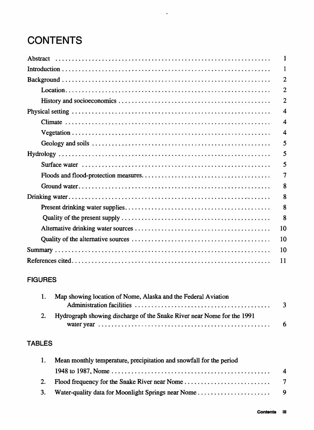
Geology and Soils
Because of its importance as a gold-mining site, the geology of the Nome area has been described in many reports (Moffit, 1907,1913; Hummel, 1960,1962; Sainsbury and others, 1972; Sainsbury, 1975; Robinson and Stevens, 1983). Bedrock exposures near Nome are found in the hills near Banner Peak, Anvil Mountain, and Newton Peak about 7 km to the northeast (fig. 1). The bedrock in these areas is principally marble with some graphitic, calcareous schist farther to the east near Banner Peak (fig. 1) (Hummel, 1962). A broad coastal plain extends from foothills near the base of Anvil Mountain, at about 100 m elevation, to the coast. The foothills are generally over lain by colluvial deposits derived from weathering of bedrock, the coastal plain is covered by gla cial outwash and till, and areas bordering the coast consist of recent beach deposits (Hopkins and others, 1960; Hummel, 1962). The coastal plain is covered by a nearly continuous mantle of loess, silty gravel, peaty silt, and peat ranging in thickness from 0.3 to more than 12m (Hopkins and oth ers, 1960). Drillers' logs from wells at the FAA facility near the airport indicate a depth to bedrock between about 10 and 15 m (Waller and Mathur, 1962).
Soils in Alaska and near Nome are described by Rieger and others (1979). Hinton and Gird- ner (1966) specifically mapped the soils near Nome and identified eight soil series in the area. Three of these soils series Kuskokwim silt loam, mine tailings, and gravelly beach are present near the FAA facilities. The dominant soil series is Kuskokwim silt loam, which consists of poorly drained silty soil having a thick surface mat of organic material. These soils are perennially frozen below about 1 m near the base of the organic mat. Most of the Seward Peninsula is underlain by continuous permafrost and the thickness of frozen ground at Nome is about 100 m (Ferrians, 1965). Except for areas adjacent to large water bodies, permafrost is typically present at shallow depths. Permafrost inhibits or prevents infiltration of water from rainfall or snowmelt.
HYDROLOGY
Nome is on the gently sloping coastal plain adjacent to Norton Sound. Several lakes and streams surround the FAA facilities. Surface water is abundant throughout the area and shallow ground water is available in limited quantities (Waller and Mathur, 1962).
Surface Water
More than 25 small lakes are present on the coastal plain near Nome between Anvil Mountain and Norton Sound. If these lakes are less than about 2 m deep, they probably freeze completely during the long cold winters. Numerous small streams and rivers traverse the coastal plain. The largest rivers near the FAA facilities are Snake River and Nome River. The Snake River flows from northeast to southwest and passes adjacent to the southwestern end of the runways at the airport (fig. 1). The Nome River flows from north to southwest and enters Norton Sound about 5 km south east of the airport between the two FAA facilities (fig. 1).
HYDROLOGY 5

For the period 1965 to 1991, mean annual flow for the Snake River near Nome measured at U.S. Geological Survey stream-gaging station No. 15621000 about 8 km northeast of Nome has been about 5.3 m3/s (U.S. Geological Survey, 1992). This flow indicates an average annual run off of about 0.024 (m3/s)/km 2 for the Nome area. Discharge records for several discontinued sites on the Nome River are available for the period 1906-1910 (U.S. Geological Survey, 1957); how ever, the stream-gaging stations are all located more than 30 km north of Nome. The streamflow at these sites was significantly affected by mining withdrawals and probably does not reflect the present flow regime near Nome. The Nome River, however, should closely follow the flow pattern of the Snake River (fig. 2). Peak annual flow will likely follow spring snowmelt in early May and be followed by several late summer rainfall peaks and declining flow throughout the winter.
275264
242
220
198
178
154
132
110
88
88
44
22
0 -11
O O UJ COCC UJa. ccIII
|O CD13 Ozul 0 CC
O
Oct Nov 1990
Dec Jan Feb Mar Apr May June 1991
July Aug Sept
Figure 2. Discharge of the Snake River near Nome for the 1991 water year.
6 Overview of Environmental and Hydrogeoiogic Conditions at Nome, Alaska

Floods and Flood Protection Measures
The primary source of flooding in the Nome area is sea waves generated by storm winds (U.S. Army Corps of Engineers, 1993). Although the U.S. Army Corps of Engineers (1993) identifies the flood hazards in Nome as low, the large open-water areas of Norton Sound provide an excellent setting for the generation of large sea waves. The maximum significant wave for the Norton Sound marine area with a return period of 100 years would reach a height of 23 m (Brower and others, 1977). The FAA facilities in Nome appear to be at an elevation less than 23 m. However, the FAA facilities are far enough inland to be outside of the zone of sea-wave flooding depicted on Flood Hazard Boundary Maps for the city of Nome (U.S. Department of Housing and Urban Development, 1974). The largest flood of record, which occurred in 1974 and caused heavy dam age to coastal buildings, was generated by storm-driven waves during high tide (U.S. Army Corps of Engineers, 1993). The effects at the FAA facilities during this flood are unknown. A breakwater constructed in 1951 along the coast provides protection from storm waves to some areas of Nome near the coast (U.S. Army Corps of Engineers, 1993). In addition to sea-wave flooding, some of the airport facilities may be affected by rainfall or snowmelt flooding or by ice-jam backwater floods (U.S. Department of Housing and Urban Development, 1974; Federal Emergency Manage ment Agency, 1983).
The Snake River and other streams in the area are subject to flooding from rainfall and snow- melt runoff and ice jams. The airport and many of the FAA facilities are close to the Snake River and lie within its 100-year flood plain (U.S. Department of Housing and Urban Development, 1974; Federal Emergency Management Agency, 1983). These areas would likely be inundated by high water from a significant flood. On August 16,1994, a flood with a discharge of about 83.5 m3/s had a peak stage that reached the northwestern end of the airport runway (Bruce Bigelow, U.S. Geological Survey, written commun., 1995). This flood discharge was exceeded at least once by a flood on June 2, 1966, when the Snake River had a discharge of about 120 m3/s (U.S. Geological Survey, 1992). A flood frequency analysis for the Snake River was completed by Jones and Fahl (1994) and is summarized in table 2. A flood with a recurrence interval between 2 and 5 years can reach the runway and may affect some FAA facilities.
Table 2. Flood frequency for the Snake River near Nome
Return period (years) 2 5 10 25 50 100 200 500
Discharge 79.3 97.4 109 123 133 143 153 165 (cubic meters per second)
In addition to inundating the runway, flood waters may initiate or accelerate erosion of stre- ambanks and overbank areas. During spring thaw, flooding caused by ice-jams may result in more damage than open-water flooding. Large volumes of ice and the high velocities are commonly associated with the release of ice jams (Beltaos, 1990).
HYDROLOGY 7

Ground Water
In Alaska, ground water is generally in limited supply along coastal areas in permafrost regions (Henshaw and Covert, 1908; Hopkins and others, 1955; Zenone and Anderson, 1978). Per mafrost can restrict ground-water flow and limit its availability to areas above or below the frozen ground. In unfrozen areas near the coast, ground water may be hydraulically connected to the ocean and subject to salt-water intrusion. Numerous wells drilled in the Nome area range in depth from 4 to 60 m below ground surface (Waller and Mathur, 1962). Water was reached at depths ranging from 1.2 to 6 m below ground surface. Many of these wells contain water of inadequate quantity or poor quality.
Moonlight Springs provides drinking water for Nome (Waller and Mathur, 1962; Munter and others, 1992; Petrik, 1991; Petrik and Noll, 1992; Petrik, 1993; and Ireland and Maurer, 1994). The springs are located about 6 km north of Nome near the base of Anvil Mountain (fig. 1). A primary recharge area for the springs is an area about 4.6 km2 in size concentrated to the north and east around the springs (Munter and others, 1992). During extended periods of reduced recharge, these springs have experienced episodes of only marginally adequate flow, such as during the spring of 1990 (Munter and others, 1992). In 1993, Moonlight Springs supplied about 1.8 million L/d of water to the city of Nome (Ireland and Maurer, 1994). Because they are near the ground surface, the spring and the shallow infiltration gallery that supply Nome with drinking water are vulnerable to contamination.
DRINKING WATER
Present Drinking Water Supplies
The city of Nome supplies drinking water to its residents through a piped system that collects Moonlight Springs water in an infiltration gallery (Petrik, 1991). The water is filtered and chlori nated prior to distribution. In 1990, water use in the city of Nome averaged about 500 L/d per per son. This is less than 30 percent of the average water use of 1,950 L/d per person for the State of Alaska (Petrik, 1991; U.S. Bureau of Census, 1991; Solley and Pierce, 1993).
Quality of the Present Supply
During the period 1954-76, the quality of water from Moonlight Springs was tested by the U.S. Geological Survey (table 3). The concentrations of analyzed constituents are within the U.S. Environmental Protection Agency (1993) and the State of Alaska Department of Environmental Conservation (1995) drinking-water regulations. Public drinking-water supplies are typically sam pled every month for compliance with current regulations.
8 Overview of Environmental and Hydrogeologlc Conditions at Nome, Aleeka

Table 3. Water-quality data for Moonlight Springs near Nome[°C, degree Celsius; m3/s, cubic meter per second; uS/cm, microsiemens per centimeter at 25 °C; mg/L, milligram per liter; ug/L, microgram per liter]
Date
06-25-5409-12-6003-18-6304-18-6406-10-6707-12-6704-23-6806-05-6807-10-6803-10-6906-22-76
Hardness total
(mg/L as CaCO3)
110130120120100
120100110130130
, Hardness, Calcium, Magnesium, Sodium, o,w«lim onto~~;,,m noncarb. dissolved dissolved dissolved fortum Sodjum PotassMjm,(mg/L as (mg/L as (mg/L as (mg/L as ads°J°n percent £"£L CaC03) Ca) Mg) Na) ratl° (mg/L as K)
710370
22009
4036434638
4338414648
3.18.62.41.92.4
2.72.32.92.63.4
2.32.12.42.42.1
1.61.72.22.72.0
0.1.1.1.1.1 .1.1.1.1.1
44444-
33443
0.60.40.30.10.50
.80
.30
.101.5.30
Date
06-25-5409-12-6003-18-6304-18-6406-10-6707-12-6704-23-6806-05-6807-10-6803-10-6906-22-76
Chloride, dissolved (mg/L as
Cl)
3.55.04.54.53.2
3.92.63.03.24.0
Sulfate, dissolved (mg/L as
S04)
9.08.06.07.03.0
5.04.25.96.68.6
Fluoride, dissolved
(mg/L as F)
0.0.0.20.10.0
.10
.0
.10
.10<.10
Silica, dissolved (mg/L as
SiO2)
5.15.14.84.65.0
4.74.24.84.34.5
Man ganese (ng/L as
Mn)
00
200 -
Iron (jig/Las
Fe)
0202030
0
290801020-
Solids, sum of
constituents, dissolved
(mg/L)
127135133136119
132114129142146
Nitrogen, nitrate,
dissolved (mg/LasNO3)
0.40.10.30.30.20
.40
.10
.0
.0--
Date
06-25-5409-12-6003-18-6304-18-6406-10-6707-12-6704-23-6806-05-6807-10-6803-10-6906-22-76
Chloride, dissolved (mg/L as
Cl)
3.55.04.54.53.2
3.92.63.03.24.0
Sulfate, dissolved (mg/L as
S04)
9.08.06.07.03.0
5.04.25.96.68.6
Fluoride, dissolved
(mg/L as F)
0.0.0.20.10.0 .10.0.10.10
<.10
Silica, dissolved (mg/L as
SiO2)
5.15.14.84.65.0
4.74.24.84.34.5
Man ganese (ng/Las
Mn)
00
200 -
Iron (jig/Las
Fe)
0202030
0
290801020-
Solids, sum of
constituents, dissolved
(mg/L)
127135133136119
132114129142146
Nitrogen, nitrate,
dissolved (mg/L as NOa)
0.40.10.30.30.20
.40
.10
.0
.0-
DRINKING WATER 9

Alternative Drinking Water Sources
Potential alternative drinking-water sources include the numerous surface-water bodies near the city of Nome.Although many of these sources are not well quantified, mean annual runoff for the area indicates that the quantity of available surface water exceeds the current needs of the city. Mean annual flow in the Snake River alone is greater than the present water use in Nome. Other surface-water sources include small lakes and ponds that are deeper than about 2 m and do not freeze completely in the winter. Shallow ground water and other springs near Moonlight Springs on Anvil Mountain may be potential sources of drinking water. Wells at the Nome FAA facilities having depths between about 14 and 20 m below ground surface yielded between about 0.13 and 1.9 L/s (Waller and Mathur, 1962). These wells provided an adequate supply of water from an aqui fer located between about 3 and 6 m below ground surface. However, use of these wells was prob ably discontinued when the city developed the public water-distribution system. The aquifer may represent an adequate alternative source for augmenting the present drinking-water supply if it becomes necessary, but shallow ground water could probably not be developed without reducing flow to the springs.
Quality of the Alternative Sources
In characterizing the recharge area of Moonlight Springs, Munter and others (1992) collected numerous surface- and ground-water samples. The only inorganic constituents in the sampled water with concentrations that exceeded Alaska drinking-water regulations were iron and manga nese (Munter and others, 1992; Alaska Department of Environmental Conservation, 1995). The highest dissolved iron concentration was 5.1 mg/L and the highest dissolved manganese concen tration was 1.4 mg/L (Munter and others, 1992). The ground water near the coast may be affected by salt water from Norton Sound. Development of surface-water sources, inland wells, or springs may all be promising alternative sources of drinking water for Nome; however, there is inadequate data available to access the quality of these sources.
SUMMARY
The FAA facilities in Nome are located on a gently sloping coastal plain near the southwest ern edge of the Seward Peninsula about 0.5 km inland from Norton Sound. The coastal plain is pre dominately covered by moist and wet tundra vegetation that reflects the poorly drained soils and the climate of the area. Soils are developed on glacial and beach deposits that overlie a nearly con tinuous layer of permafrost. Surface water is abundant and ground water is locally available in the Nome area. Drinking water is currently provided by Moonlight Springs through a public distribu tion system. Alternative supplies of drinking water are available from nearby surface-water sources, untapped springs, and new or abandoned wells, but the present quality and quantity of these sources is unknown.
10 Overview of Environmental and Hydrogeoiogic Conditions st Nome, Alaska

REFERENCES CITED
Alaska Consultants, 1968, City of Nome comprehensive development plan: Anchorage, Alaska Consultants, 162 p.
Alaska Department of Community and Regional Affairs, 1994, Community profile Nome: Alaska Department of Community and Regional Affairs Municipal and Regional Assistance Division, Community Database, Research and Analysis Section report.
Alaska Department of Environmental Conservation, 1995 State of Alaska drinking water regulations 18AAC80: Alaska Department of Environmental Conservation, 87 p.
Alaska Department of Fish and Game, 1986, The role of fish and wildlife in the economies of Barrow, Bethel, Dilling- ham, Kotzebue, and Nome: Alaska Department of Fish and Game Technical Paper 154,90 p.
Alaska Department of Transportation and Public Facilities, 1979, Nome-Council Road environmental assessment: Alaska Department of Transportation and Public Facilities report, 92 p.
___1983, Nome Airport Nome City Field airport master plan summary: Fairbanks, Alaska Department of Trans portation and Public Facilities report, 10 p.
Beltaos, Spyridon, 1990, Breakup jams, in Ryan, R.L., and Crissman, R.D., eds., Cold regions hydrology and hydrau lics: American Society of Civil Engineers Monograph, p. 485-510.
Brower, W.A. Jr., Diaz, H.F., Prechtel, A.S. Searby, H.W. and Wise, J.L., 1977, Climatic atlas of the outer continental shelf waters and coastal regions of Alaska Volume II, Bering Sea: University of Alaska, Anchorage, Arctic Environmental Information and Data Center, Publication B-77,443 p.
Ecology and Environment, Inc., 1992, Environmental compliance investigation report, Nome FAA station, Nome Alaska: Copy available through the Environmental Compliance Section, AAL-465, Federal Aviation Administra tion, Alaska Regional Office, Anchorage, Alaska.
Federal Emergency Management Agency, 1983, Flood insurance study City of Nome: Federal Emergency Manage ment Agency report, 17 p.
Ferrians, O.J., Jr., 1965, Permafrost map of Alaska: U.S. Geological Survey Miscellaneous Geologic Investigations Map 1-445, 1 sheet, scale 1:250,000.
Hartman, C.W., and Johnson, P.R., 1984, Environmental atlas of Alaska: University of Alaska Fairbanks, Institute of Water Resources/Engineering Experiment Station, 95 p.
Henshaw, F.F., and Covert, C.C., 1908, Water supply investigations in Alaska, 1906-1907 (Nome and Kougarok regions, Seward Peninsula; Fairbanks district, Yukon-Tanana region): U.S. Geological Survey Water-Supply Paper 218, 156 p.
Hinton, R.B., and Girdner, C.L., 1966, Soils of the Nome area, Alaska: U.S. Department of Agriculture, Soil Conser vation Service report, 30 p.
Hopkins, D.M., Karlstrom, T.N.V. and others, 1955, Permafrost and ground water in Alaska: U.S. Geological Survey Professional Paper 264-F, p. 113-146.
Hopkins, D.M., MacNeil, F.S., and Leopold, E.B., 1960, The coastal plain at Nome, Alaska A late Cenozoic type section for the Bering Strait region: International Geological Congress, 21st, Copenhagen, 1960, Report, part 4, p. 46-57.
Hummel, C.L., 1960, Structural geology and structural control of mineral deposits in an area near Nome, Alaska: Geo logical Society of America Bulletin, v. 71, no. 2, p. 2063.
_____1962, Preliminary geologic map of the Nome C-l quadrangle, Seward Peninsula, Alaska: U.S. Geological Survey Miscellaneous Field Studies Map MF-247, scale 1:63,360,1 sheet.
Ireland, Roy and Maurer, M.A., 1994, Summary of water-use data in Alaska, 1993: Alaska Division of Geological and Geophysical Surveys Public Data File 94-53.
Jones, S.H., and Fahl, C.B., 1994, Magnitude and frequency of floods in Alaska and conterminous basins of Canada: U.S. Geological Survey Water-Resources Investigations Report 93-4179, 122 p.
REFERENCES CITED 11

Leslie, L.D., 1989, Alaska climate summaries (2d ed.): University of Alaska Anchorage, Alaska Arctic Environmental Information and Data Center, Climate Center Technical Note 5.
Moffit, F.H., 1907, The Nome region: U.S. Geological Survey Bulletin 314-G, p. 126-145.
___1913, Geology of the Nome and Grand Central quadrangles, Alaska: U.S. Geological Survey Bulletin 533,140 p.
Munter, J.A., Maurer, M.A., Inghram, M.G., and others, 1992, Recharge area evaluation for Moonlight Springs, Nome, Alaska: Alaska Division of Geological and Geophysical Surveys Report of Investigations 92-2, 69 p.
Petrik, W.A., 1991, Estimated use of water in the United States 1990 Selected large Alaskan public water suppliers doc umentation and data forms: Alaska Division of Geological and Geophysical Surveys Public Data File 91-26, 179 p.
_____1993, Summary of water-use data in Alaska, 1992: Alaska Division of Geological and Geophysical Surveys Public Data File 93-82.
Petrik, W.A. and Noll, R.S., 1992 Summary of water-use data in Alaska, 1991: Alaska Division of Geological and Geo physical Surveys Public Data File 92-25,48 p.
Rieger, Samuel, Schoephorster, D.B., and Furbush, C.E., 1979, Exploratory soil survey of Alaska: Soil Conservation Ser vice report, 213 p.
Robinson, M.S., and Stevens, D.L., 1983, Geologic map of the Seward Peninsula, Alaska: Alaska Division of Geological and Geophysical Surveys Report of Investigations 83-20,1 sheet.
Sainsbury, C.L., 1975, Stratigraphy and tectonics of the Seward Peninsula, Alaska Contributions geology Bering Sea Basin and adjacent regions: Geological Society of America Special Paper 151, p. 184-185.
Sainsbury, C.L., Hummel, C.L., and Hudson, T, 1972, Reconnaissance geologic map of the Nome quadrangle, Seward Peninsula, Alaska: U.S. Geological Survey Open-File Report 72-326, 28 p.
Solley, W.B., and Pierce, R.R., 1993, Estimated use of water in the United States in 1990: U.S. Geological Survey Circular 1081,76 p.
Thomas, D.C., 1980, Nome salmon subsistence research report: Alaska Department of Fish and Game Division of Sub sistence Technical Paper 11,14 p.
U.S. Army Corps of Engineers, 1974, Operation and maintenance of the Nome harbor and seawall, Nome, Alaska Final environmental impact statement: U.S. Army Corps of Engineers Alaska District, 68 p.
____1990, Environmental assessment Defense environmental restoration program Nome area sites, Alaska: Anchorage, U.S. Army Corps of Engineers, Alaska District, 82 p.
___1993, Alaskan communities flood hazard data: U.S. Army Corps of Engineers, Alaska District, 335 p.
U.S. Bureau of Census, 1991, Percent distribution Alaska population by sex, race and Hispanic origin 1990 census: Compiled by Alaska Department of Labor, Research and Analysis, 3 p.
U.S. Environmental Protection Agency, 1993, Drinking water regulations and health advisories: U.S. Environmental Pro tection Agency report, lip.
U.S. Geological Survey, 1957, Compilation of records of quantity and quality of surface waters in Alaska through Sep tember 1950: U.S. Geological Survey Water-Supply Paper 1372, 262 p.
___1992, Water resources data for Alaska, water year 1990: U.S. Geological Survey Water-Data Report AK-91-1, 252 p.
U.S. Department of Housing and Urban Development, 1974, Flood hazard boundary map City of Nome: U.S. Depart ment of Housing and Urban Development report, 3 sheets
Viereck, L.A, and Little, E.L., 1972, Alaska trees and shrubs: U.S. Department of Agriculture, Agriculture Handbook No. 410,265 p.
Waller, R.M., and Mathur, S.P., 1962, Data on water supplies at Nome, Alaska: U.S. Geological Survey Hydrological Data Report 17,12 p.
Zenone, Chester and Anderson, G.S., 1978, Summary appraisals of the nation's ground-water resources Alaska: U.S. Geological Survey Professional Paper 813-P, 28 p.
12 Overview of Environmental and Hydrogeologic Conditions at Nome, Alaska