Outagamie County, Wisconsin August 6 & 7, 2013 Tornadoes ...ftpcontent.worldnow.com/wbay/Outagamie...
16
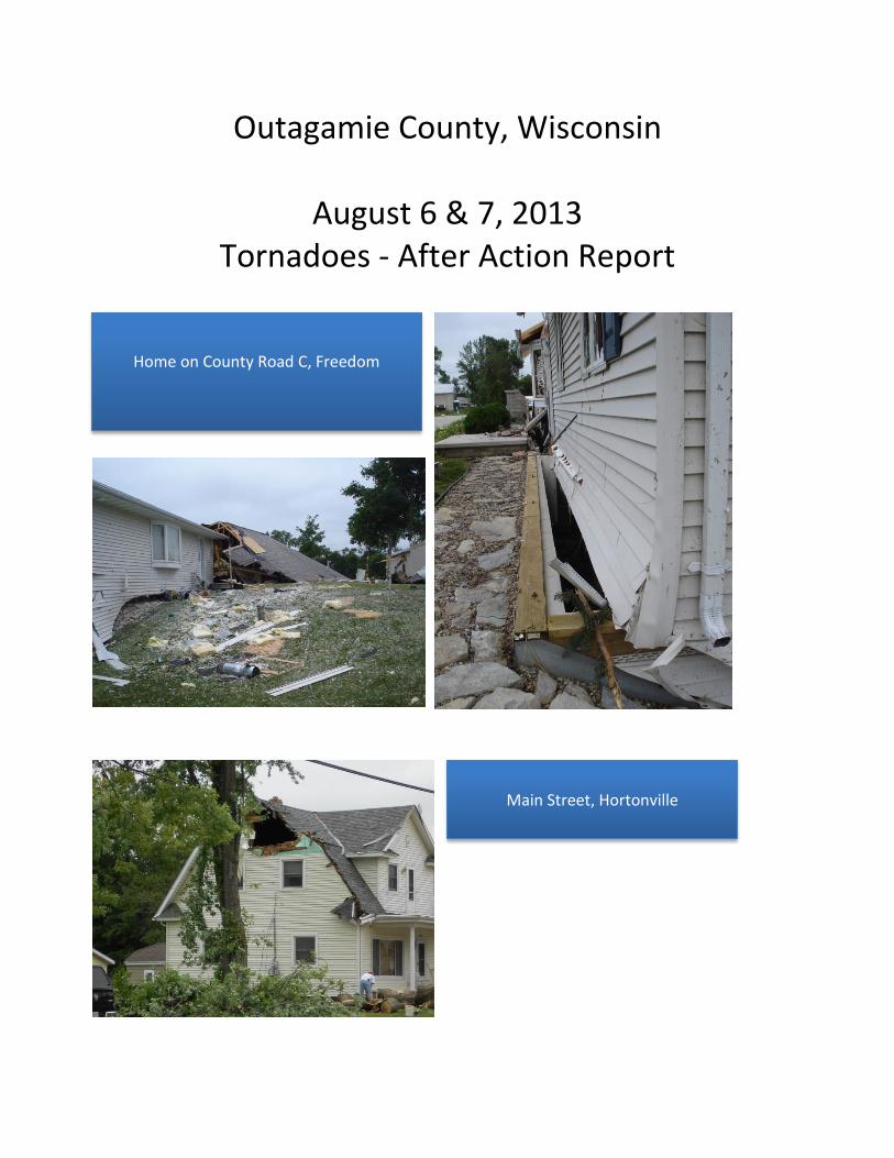
Outagamie County, Wisconsin August 6 & 7, 2013 Tornadoes - After Action Report Main Street, Hortonville Home on County Road C, Freedom
Transcript of Outagamie County, Wisconsin August 6 & 7, 2013 Tornadoes ...ftpcontent.worldnow.com/wbay/Outagamie...
Outagamie County, Wisconsin
August 6 & 7, 2013 Tornadoes - After Action Report
Main Street, Hortonville
Home on County Road C, Freedom
Outagamie County August 2013 Tornado AAR 2
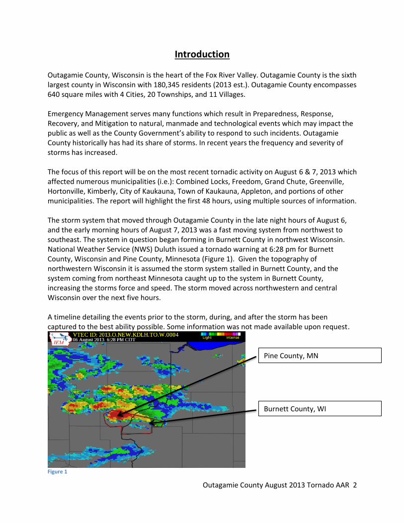
Introduction Outagamie County, Wisconsin is the heart of the Fox River Valley. Outagamie County is the sixth largest county in Wisconsin with 180,345 residents (2013 est.). Outagamie County encompasses 640 square miles with 4 Cities, 20 Townships, and 11 Villages. Emergency Management serves many functions which result in Preparedness, Response, Recovery, and Mitigation to natural, manmade and technological events which may impact the public as well as the County Government’s ability to respond to such incidents. Outagamie County historically has had its share of storms. In recent years the frequency and severity of storms has increased. The focus of this report will be on the most recent tornadic activity on August 6 & 7, 2013 which affected numerous municipalities (i.e.): Combined Locks, Freedom, Grand Chute, Greenville, Hortonville, Kimberly, City of Kaukauna, Town of Kaukauna, Appleton, and portions of other municipalities. The report will highlight the first 48 hours, using multiple sources of information. The storm system that moved through Outagamie County in the late night hours of August 6, and the early morning hours of August 7, 2013 was a fast moving system from northwest to southeast. The system in question began forming in Burnett County in northwest Wisconsin. National Weather Service (NWS) Duluth issued a tornado warning at 6:28 pm for Burnett County, Wisconsin and Pine County, Minnesota (Figure 1). Given the topography of northwestern Wisconsin it is assumed the storm system stalled in Burnett County, and the system coming from northeast Minnesota caught up to the system in Burnett County, increasing the storms force and speed. The storm moved across northwestern and central Wisconsin over the next five hours. A timeline detailing the events prior to the storm, during, and after the storm has been captured to the best ability possible. Some information was not made available upon request.
Figure 1
Burnett County, WI
Pine County, MN

Outagamie County August 2013 Tornado AAR 3
Figure 2
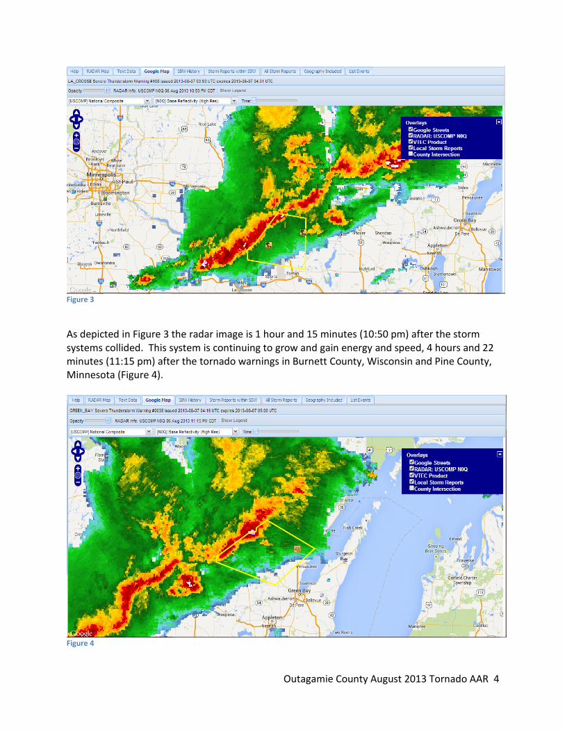
Depicted in Figure 2 is a radar image from NWS La Crosse approximately 3 hours and 7 minutes (9:35 pm) after the storm system from Burnett County and a system which was moving through northeastern Minnesota have collided into a larger system. This storm has gained speed and energy as it travels east southeast at approximately 50 mph and winds at 60 mph. NWS Duluth, NWS Minneapolis, as well as NWS La Crosse had issued numerous storm warnings and updates. This storm was visible on radar at NWS Green Bay at 9:30pm if not earlier.
Outagamie County August 2013 Tornado AAR 4
Figure 3
As depicted in Figure 3 the radar image is 1 hour and 15 minutes (10:50 pm) after the storm systems collided. This system is continuing to grow and gain energy and speed, 4 hours and 22 minutes (11:15 pm) after the tornado warnings in Burnett County, Wisconsin and Pine County, Minnesota (Figure 4).
Figure 4
Outagamie County August 2013 Tornado AAR 5
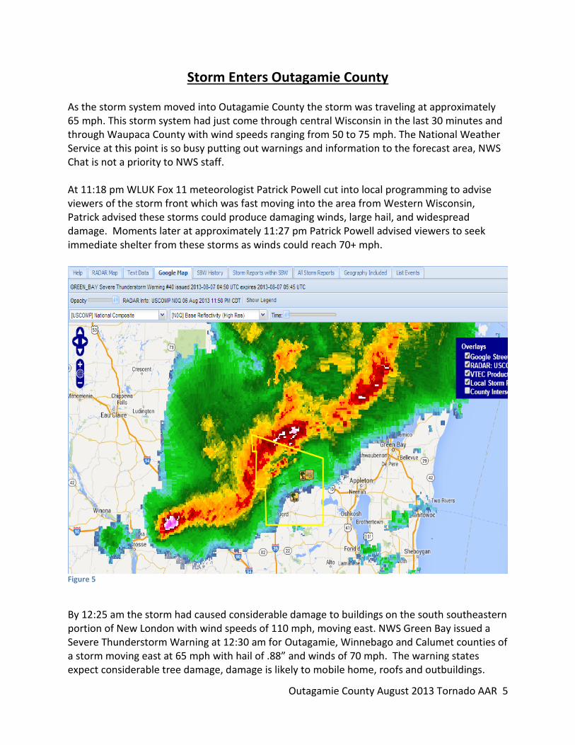
Storm Enters Outagamie County As the storm system moved into Outagamie County the storm was traveling at approximately 65 mph. This storm system had just come through central Wisconsin in the last 30 minutes and through Waupaca County with wind speeds ranging from 50 to 75 mph. The National Weather Service at this point is so busy putting out warnings and information to the forecast area, NWS Chat is not a priority to NWS staff. At 11:18 pm WLUK Fox 11 meteorologist Patrick Powell cut into local programming to advise viewers of the storm front which was fast moving into the area from Western Wisconsin, Patrick advised these storms could produce damaging winds, large hail, and widespread damage. Moments later at approximately 11:27 pm Patrick Powell advised viewers to seek immediate shelter from these storms as winds could reach 70+ mph.
Figure 5
By 12:25 am the storm had caused considerable damage to buildings on the south southeastern portion of New London with wind speeds of 110 mph, moving east. NWS Green Bay issued a Severe Thunderstorm Warning at 12:30 am for Outagamie, Winnebago and Calumet counties of a storm moving east at 65 mph with hail of .88” and winds of 70 mph. The warning states expect considerable tree damage, damage is likely to mobile home, roofs and outbuildings.

Outagamie County August 2013 Tornado AAR 6
The Village of Hortonville is in the direct path of this storm and by 12:32 am the Village of Hortonville is without power and trees are damaged along with homes. The storm is tracking to the east and by 12:36 am enters the Town of Greenville, causing wide spread power failure and wind damage. The storm tracked a line along Highway 15 from the west to Manley Road and continued along Highway 15 to Highway 76 in Greenville and then projected back to the northeast. The storm system would impact northwestern Grand Chute, southern Center and moved into Freedom, Kimberly and Combined Locks.

Outagamie County August 2013 Tornado AAR 7
Response to the Storm The Outagamie County Communication Center (911) started receiving calls at approximately 12:28 am on August 7, 2013 resulting not only from the severe thunderstorm but also the impact of two unknown tornadoes on the ground. At 12:32 am Hortonville Police Department reported power out in Hortonville and a report of a tree on a house on Nash Street. The Communications Center is extremely busy at this point handling 911 phone calls, police/fire/EMS radio traffic, as well as managing other sources of communication. The Communication Center would appear chaotic to an untrained individual, although busy the Communication Center is operating like an orchestra. The severe thunderstorm has been in Outagamie County for a short time and is unleashing its fury, at 12:34 am the Communications Center Supervisor Angela Owens contacts the Emergency Management Director Julie Loeffelholz and advises her that the Village of Hortonville and the Town of Greenville were without power, as well as the Communications Center. Emergency response agencies are responding to multiple incidents across the county. The Director states she is enroute to the Communication Center and arrives at 12:36 am. The Emergency Management Director established a workspace near the Communication Center Supervisor to monitor the storm situation. Also the Emergency Management Director sets up the work iPad to monitor NWS Chat which automatically posts all weather watches, warnings, incoming damage reports received by NWS and is a non-emergency communication chat with NWS Green Bay. Other actions taken by the Director during the next four to six hours is not fully known as there is limited documentation. At this time the first two unknown tornadoes have ended and a third unknown tornado is on the ground north of Greenville. An off-duty Grand Chute law enforcement officer called into the Communication Center at 12:37 am stating everything was flying and her deck is gone in Greenville. At 12:37 am a 911 caller stated a tornado came through although nothing specific was given to the telecommunicator. At least one time the telecommunicator’s said out loud "tornado" after hanging up from a 911 call with a citizen and then took the next call in line. The Emergency Management Director heard "tornado" and took the time to correct the telecommunicator by saying it is not a tornado, but states it is straight line winds, because National Weather Service has not yet issued a Tornado warning. At 12:38 am a fourth unknown tornado is also on the ground near Mackville followed by a fifth unknown tornado at 12:40 am near Freedom. Citizens from Hortonville call in of trees down and a road blocked. Then at 12:41 am the Communication Center Supervisor contacts Baycomm because of radio transmissions problems at the Communication Center and this situation occupies most of the supervisor’s time along with supporting the staff with the high call volume. 911 phone calls continue as the Communication Center uses alternate methods to dispatch Police and Fire.
Outagamie County August 2013 Tornado AAR 8
At 12:43 am the New London Fire Department calls to report a tornado touchdown because of heavy damage on Jennings Road and at 12:50 am a citizen calls of a tornado by the railroad tracks outside of Hortonville on Highway 15 with barns and house down. The third unknown tornado has ended. At 12:53 am there is a 911 phone call from Freedom with a report of a tornado came through and there is a tree in the house. At this time the fourth unknown tornado has ended. Shortly afterwards a resident from Grand Chute and also from Kimberly call to report seeing and hearing a tornado. At 12:57 am a 911 call of an apartment building in Hortonville with the roof gone and smell smoke and is requesting assistance. At about 1 am a volunteer with the Amateur Radio Emergency Services arrives to assist in coordinating damage reports from field storm spotters to the Emergency Management Director and the Communication Center Supervisor. The Emergency Management Director also assists the Communication Center Supervisor by answering the supervisor desk phone. At approximately 1:07 am the storm had left Outagamie County. Over the four hours after the storm over 400 phone calls come into the Communication Center with Calumet and Winnebago County 911 handling the overflow. Following the storm event, the Emergency Management Director stated in a written document to the press that following the storm event, “I immediately activated the County Emergency Operations Center to provide all resources from the County to assist in responding to the storm”. Staff Sgt. Hollmann arrived after 2:11 am to assist with the supervisory phone line in the Communication Center because of the call volume. Later at approximately 3:00 am Maintenance Director, Jerry Wittman is notified the downtown campus is without power and on the generator. The first notification to the County Executive or Deputy Executive by the Emergency Management Director regarding the storm appears to be at 4:45 am. The County Executive (time unknown) notifies other Emergency Operations Center staff (which staff is unknown) of the situation and that the Emergency Operations Center will be activating. Based on lessons from the April 2013 ice storm following the Emergency Response Plan and utilizing E-sponder Alerts to automatically notify EOC personnel is suggested. At 7:20 am two MIS personnel voluntarily responded to the EOC based upon the media reports of damage in the county. Upon their arrival, the EOC was unoccupied. The personnel take the initiative to setup the Emergency Operations Center tables and equipment in anticipation that it may be needed. HHS/Public Health was notified at 7:00 am of the EOC activation and of the 8:00 am EOC briefing. Health and Human Services activated their Department operations Center at 7:30 am in support of the division response to the storm.

Outagamie County August 2013 Tornado AAR 9
The first briefing in the EOC was at 8:00 am on August 7th and the County Executive declared an emergency at the same time. Also later the same day a media release was sent to all media outlets of the damage assessment hotline available to residents by the Emergency Management Director. The damage assessment hotline was established on the Emergency Management Directors main phone number. A morning and afternoon briefings were held in the EOC starting August 7th, 8th and 9th. Daily briefings were held on August 10th, 12th, 13th, and 14th in the EOC, however only partial notes are available of discussion and actions taken. Personnel did not stay in the EOC for the storm response, but only came for the briefings and returned to their office. The EOC purpose is to provide a central location for multiple departments and agencies to coordinate and support incident response and recovery. It is suggested that Emergency Management should review Emergency Support Function #5 of the County Emergency Response Plan on the purpose and the utilization of the EOC during disaster response and recovery.
Outagamie County August 2013 Tornado AAR 10
Assessing the Storm Damage
After any storm causing major damage a crucial step is the Preliminary Damage Assessment (PDA) which is the ongoing evaluation of buildings and infrastructure to determine the extent of damage in the county, determine dollar figures for State or Federal support and the ability to use or occupy structures. Some damage assessment takes place during the rapid assessment phase (windshield), but a more detailed and greater evaluation process is needed to account for all damage incurred during the event. On the morning of August 7th County Executive Nelson, Emergency Management Director Loeffelholz, and HHS Emergency Preparedness Planner Garcia conducted a windshield assessment of some affected areas of the County as documented by HHS. Damage reports or locations covered of this damage assessment are unknown from documentation. Grand Chute initiated PDA on August 7th and a full damage assessment on August 8th utilizing the paper method for documentation. Grand Chute used town staff to conduct the damage assessment. Brown County Emergency Management Director Paul Gazdik assisted with initial damage observations in the Freedom and Wrightstown area. Mr. Gazdik’s findings and communication back to Outagamie County are not available at the time of this report. Winnebago County Emergency Management Director Linda Kollman’s assistance was requested with coordinating damage assessment throughout the county and she arrived on August 8th to assist in the EOC. On August 8th an E-sponder Alert was sent to the Community Emergency Response Team (CERT) to assist with damage assessment in Hortonville. The county started damage assessment in Hortonville on the 8th and Freedom on the 9th. An Incident Management Team (IMT) was requested to respond to assist with damage assessment in the Kimberly and Combined Locks area. There is no documentation as to the request or the arrival of the IMT. The IMT misreported damage in Kimberly that caused confusion for the community in requesting disaster financial assistance. Since the IMT’s main mission is usually not damage assessment a follow-up training for the team to understand the damage assessment process and procedures is suggested. Damage assessment was conducted in Hortonville by the Outagamie County Planning Department and CERT using iPads that located damaged homes and businesses on the county map using Global Positioning (GPS) and cellular communication. The computer program utilized is an ARC/GIS (Geographical Information System) provided by the Planning Department. The program allows for the property information to be accurately documented along with photographs of the property and the damage. The information is stored on the county’s mainframe server and is able to be printed or shared electronically with other agencies, showing the path of a storm and locations of damage throughout the county. The ARC/GIS
Outagamie County August 2013 Tornado AAR 11
software has been upgraded by the Planning Department since the August tornado’s and has been installed on two of the four iPads in the Emergency Management Office. Utilization of the software also allows other agencies to have a history of the property, (i.e. tax records, building permits, insurance agencies, etc.). The information obtained through the damage assessment process is updated by the Planning Department using information provided by the software as well as paper documentation of the damage. This information is communicated through the briefings in the EOC and shared with the affected municipalities electronically and hardcopy. The information is then updated on the Uniform Disaster Situation Report (UDSR) and shared with Wisconsin Emergency Management. Wisconsin Emergency Management collects all damage dollar amounts (statewide) and utilize this information in determining if the damage meets two thresholds, which must be met under the Stafford Act, a state threshold and a county threshold. These thresholds are based on a pre-determined legal formula that disaster damages must exceed. The formula uses population of the jurisdiction as determined in the last official U.S. Census which is then entered to multiply population by $3.50 per capita for counties and $1.39 per capita for the state (FY2014) $3.45 per capita for counties and $1.37 per capita for the state (FY2013). The Stafford Act recognizes that primary responsibility for emergency management is at the local level; thus, Stafford Act assistance is intended to be available only as a supplement to other governmental and non-governmental resources. The Act instructs Governors to base their declaration requests on the finding that the disaster is of such severity and magnitude that effective response is beyond the capabilities of the State and the affected local governments and that Federal assistance is necessary. The Stafford Act is not intended to provide assistance for every event that impacts a State or county, so FEMA established evaluation factors based on this principle. The Wisconsin Disaster Fund was created by Wisconsin Act 269 and signed into law in April 2006. Wisconsin Emergency Management was designated as the agency responsible for administering the fund and developed an Administrative Rule, WEM 7, for this purpose. The Wisconsin Disaster Fund (WDF) is a state funded reimbursement program intended to assist county, local and tribal units of government recoup costs incurred in responding to, and recovering from, natural disasters. WDF is administered within the Response and Recovery Bureau of Wisconsin Emergency Management (WEM). The state contributes 70% of the costs, with the local government contributing the remaining 30%. The fund does not cover losses suffered by individuals, businesses or the agricultural sector, or those covered by insurance. It also does not provide management or administrative costs for the applicants. For an applicant to qualify for assistance through WDF, federal disaster assistance is not available to them either because the governor’s request for a declaration has been denied or no federal assistance has been requested because the disaster does not meet the statewide or countywide per capita impact indicator. Only local units of government that reach the countywide per capita impact indicator (i.e., county threshold) will be eligible for assistance.

Outagamie County August 2013 Tornado AAR 12
This threshold amount is adjusted annually on or about October 1st and is based on the Consumer Price Index. The local unit of government must have declared a state of emergency in order to qualify. In many ways, WDF mirrors FEMA’s Public Assistance Program and is guided by the Robert T. Stafford Disaster Relief and Emergency Assistance Act, 42 U.S.C. §5121 et seq. as amended. Proper damage assessment is essential in order to report damages in a timely fashion to the local, state, and federal governments.

Outagamie County August 2013 Tornado AAR 13
Improvement Matrix
Situation Improvement Responsible Emergency Response Plan Utilization of the Emergency
Response Plan and the ESF’s contained within it.
EM Director
Emergency Operations Center Activation
Utilization of Esponder for EOC Activation.
EM Director and Deputy EM Director
Weather Monitoring Use and understand the use of current technologies in the office. NWS Chat, iNWS, Radarscope, WeatherSentry, NWS Radar.
EM Director and EM Staff
Esponder Train on and be familiar with Esponder and the operations of the program
EM Director and Deputy EM Director
Alerting Solutions Software & Compulert Software
Training and operation of the siren activation software utilized.
EM Director and Deputy EM Director
Citrix Training in the use of Citrix Software in order to remotely access County computer programs and software.
EM Director and Deputy EM Director
Emergency Operations Center In-Service
Train and Refresh County staff in EOC Operations and procedures.
EM Director and Training and Exercise Coordinator
Emergency Response Plan In-Service
Train and Refresh County staff in the Emergency Response Plan and the ESF’s contained within it.
EM Director and Training and Exercise Coordinator
Emergency Center Operations and ICS Interface
Attend Emergency Operations Center Training
EM Director and Deputy EM Director
Volunteer Agency Coordination
Ensure Better Coordination of Volunteer Agencies( i.e. ARES, VOAD, 211, Volunteer Center, CERT)
EM Director and Deputy EM Director
Outagamie County August 2013 Tornado AAR 14
Summation/Conclusion
In response to the storms of August 6 & 7, 2013 the individual On-call for Emergency Management was not in position prior to the storms arrival in Outagamie County. The potential of these thunderstorms was well documented in prior Severe Thunderstorm Warnings from the National Weather Service in the hours preceding the specific warning for Outagamie County (at 12:30 a.m.). There were many tools which could have been utilized in preparation for the storm’s arrival in Outagamie County, allowing the county to alert the citizens and public prior to the weather event and facilitate an immediate response. Did the County respond certainly, but not in a timely fashion to support communities; communities waited until Thursday to start receiving a partial response to the storm and for staff assisting the communities. Was the Emergency Response Plan followed and were appropriate ESF’s activated, and documented? It is unknown as this information is unavailable and no documentation has been provided or located to support the proper utilization of the Emergency Response Plan and the ESF’s contained within. The purpose of the Emergency Response Plan is to act as a guide to ensure procedures and processes are followed. One of the procedures to follow is the filing of a Uniform Disaster Situational Report (UDSR) within 24 hours to Wisconsin Emergency Management; this did not happen until August 9th nearly 72 hours after the event. As a result of a windshield view of damage in the county, the County Executive’s focus was on acquiring assistance from the National Guard in cleaning up the damage. In communication with Major General Donald P. Dunbar the Adjutant General of Wisconsin, consultation with the General prior to any public declaration to the media of the National Guard assistance would have clarified if the Guard could assist in clean up. Also in ESF # 7 the procedures for requesting assistance from the National Guard are listed to assist in this process. The National Guard did respond to the county and conducted an assessment though Outagamie County did not meet the criteria for a response for assistance. The County hired EPTEC Inc. to assist and coordinate debris management for the impacted communities. Hiring EPTEC Inc. was a very beneficial decision to all of the affected communities. EPTEC Inc. ensured that all of the debris storage sites had the proper permitting in place through the Department of Natural Resources (DNR). Health and Human Services responded to the communities on Wednesday and supported the licensed facilities throughout the county as well as facilities and agencies requesting assistance from HHS, no matter the division HHS responded. HHS also had offerings of mutual aid or assistance from other counties, which proved to be beneficial in the event it would have been needed.
Outagamie County August 2013 Tornado AAR 15
CERT assisted HHS with door drops of safety and contact information to residents in Hortonville. This proved to be the best way to get the information out to the community as people were in the process of cleaning up, without power and distracted with the storm that it was important to have contact with the residents. HHS was utilizing their department operations center to support staff and facilities affected by the storm. This is something HHS has practiced and utilized in previous incidents. The National Weather Service is the primary source for weather information and declaring warnings however it cannot be relied on as the only source for situational awareness. The situation in Outagamie County on August 6/7, 2013 was obviously very different than what the NWS was reporting. Situational awareness is the key to saving lives and protecting property. The situation was such that the community was reporting storm damage that could cause great bodily harm and or death. The Emergency Management Director solely relied on NWS warnings to determine the events occurring in the county. NWS requests annually that storm reports (such as tornadoes, funnel clouds, flooding, tree damage, etc.) received by Emergency Management and trained spotters to be passed to NWS so as to adjust current warnings or issue new weather warnings. The Communication Center is also requested to pass these reports after the influx of 911 phone calls are resolved. The storm and damage reports being received and overheard were much stronger and dangerous than the NWS warnings issued. These reports should not have been dismissed but passed to NWS, especially with public safety personnel reporting the tornadoes. NWS role is to sift through the damage reports to determine if the report is relevant and whether or not to change or update the weather warning. As time progressed some things progressed in a positive manner for the communities affected such as; damage assessment being conducted and properly reported, volunteers were being coordinated for assisting with debris removal by the Volunteer Center and the volunteers being managed by CERT. At the time of this report Outagamie County had received a total of $288,000.00 for the affected communities (Hortonville, Freedom, Grand Chute, Combined Locks, Kimberly, Greenville) which met the per capita threshold for the Wisconsin Disaster Fund; of the approved $500,000.00 grant through the Community Development Block Grant which cost $35,000.00 to administer through the East Central Wisconsin Regional Planning Commission, leaving $465,000.00 available for disbursement to private residents had only disbursed $14,000.00 year to date to 7 approved applicants. The County Executive in an effort to show diligence had FVTC provide a report on the storm, and the focus was on only the first hour of the storm response and make recommendations to improve response at a cost of $6,000.00.
Outagamie County August 2013 Tornado AAR 16
In summation, there were a total of 99 weather statements pertaining to this storm system from the NWS, Duluth, Minneapolis, La Crosse, Milwaukee/Sullivan, National Storm Prediction Center, and Green Bay. Weather statements from outside our forecast area totaled 70; weather statements from within our forecast area were 28, and 1 statement from the Storm Predication Center (SPC) in Norman, Oklahoma. These weather statements are available to Emergency Management in just a few mouse clicks on the internet, weather statements from NWS GRB are e-mailed automatically to the Emergency Management staff and those e-mails are disseminated to iPads, iPhones, and computers all on the county computer network. Weather radar resources through the NWS, Radarscope and Weather Sentry (Emergency Management Director and Communications Center only) are available as well to Emergency Management staff. The weather statements, weather radar, and information shared from other counties are tools to increase situational awareness in order to alert the public of a threat to their safety, and for response agencies to prepare (even if only minutes prior to the event) for an immediate response to an event. The tornado’s which descended on the Fox Valley on August 6 & 7, 2013 caused an estimated $6 million in damage and endangered the lives of our residents, should have had a more appropriate, effective, and efficient response. The residents of Outagamie County deserve to have full faith in the County that an appropriate, effective and efficient response will be in place to support the citizens in their time of need.