OSS AS A BACKBONE FOR EDUCATION IN GEO-INFORMATICS Morales.pdf · 03/05/2012 · OSS AS A BACKBONE...
20
OSS AS A BACKBONE FOR EDUCATION IN GEO-INFORMATICS GEOSPATIAL WORLD FORUM 2012 JAVIER MORALES
Transcript of OSS AS A BACKBONE FOR EDUCATION IN GEO-INFORMATICS Morales.pdf · 03/05/2012 · OSS AS A BACKBONE...
OSS AS A BACKBONE FOR EDUCATION IN
GEO-INFORMATICS GEOSPATIAL WORLD FORUM 2012
JAVIER MORALES
© Department of Geo-information Processing (GIP) – 5/3/2012 – 2
AFFILIATION
SDIT is a research group on SDI Technology at ITC, University of
Twente, The Netherlands.
We partner with governments, NGOs, and private sector worldwide, on
technical SDI development.
Partners in:
capacity building
joint research
joint development
www.itc.nl/research/themes/sdit/default.asp
© Department of Geo-information Processing (GIP) – 5/3/2012 – 3
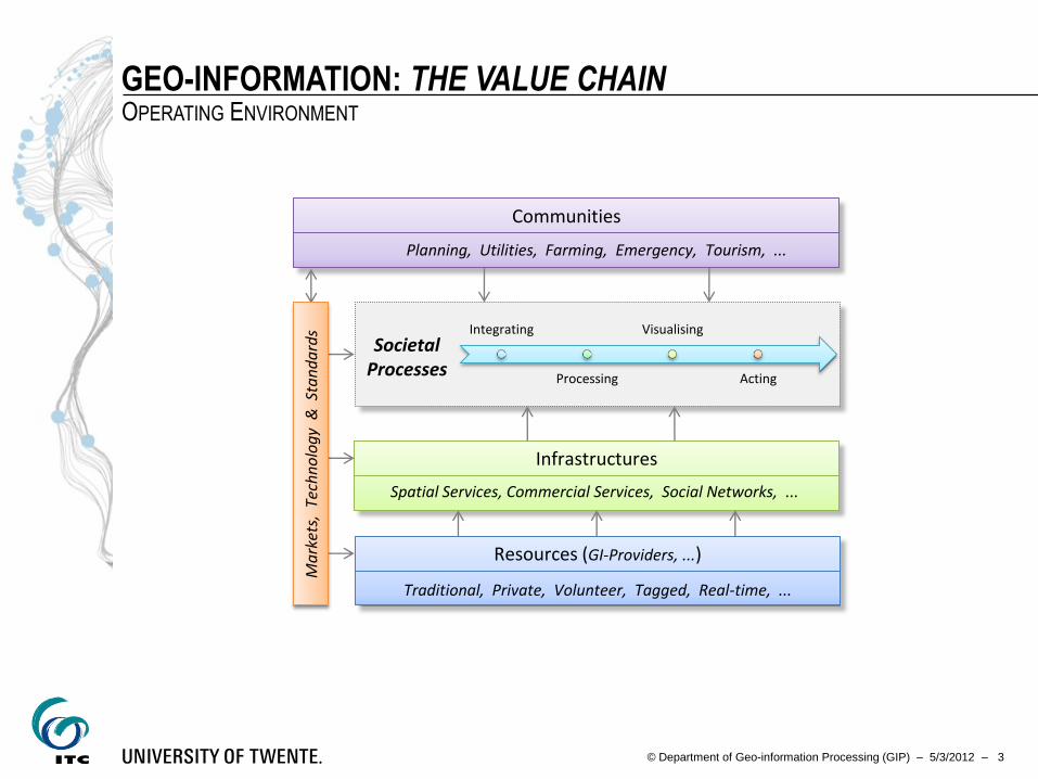
GEO-INFORMATION: THE VALUE CHAIN OPERATING ENVIRONMENT
Integrating
Processing
Visualising
Acting
Infrastructures
Resources (GI-Providers, ...)
Traditional, Private, Volunteer, Tagged, Real-time, ...
Spatial Services, Commercial Services, Social Networks, ...
Communities Planning, Utilities, Farming, Emergency, Tourism, ...
Ma
rket
s, T
ech
no
log
y &
Sta
nd
ard
s
Societal Processes
© Department of Geo-information Processing (GIP) – 5/3/2012 – 4
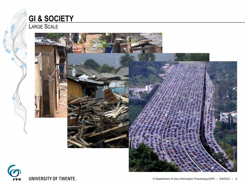
GI & SOCIETY LARGE SCALE
© Department of Geo-information Processing (GIP) – 5/3/2012 – 5
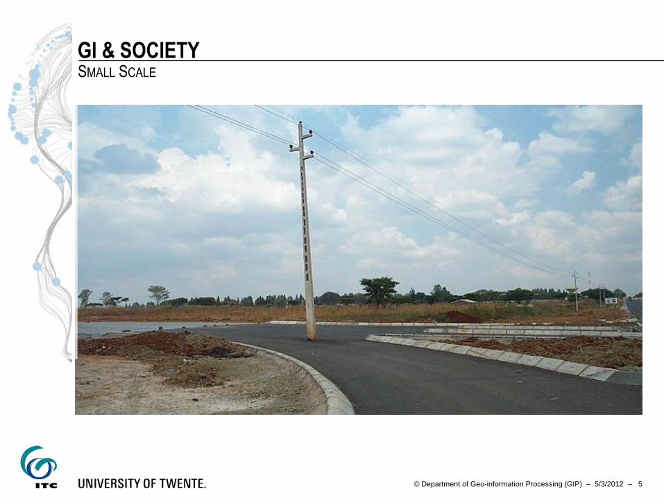
GI & SOCIETY SMALL SCALE
© Department of Geo-information Processing (GIP) – 5/3/2012 – 6
GI-SYSTEMS TECHNOLOGICALLY DEFINED
A community of actors working in an IT environment
With a special interest in geospatial resources
Wanting to take part in a communication process
With well-understood responsibilities
Involving service offerings & service consumptions
© Department of Geo-information Processing (GIP) – 5/3/2012 – 7
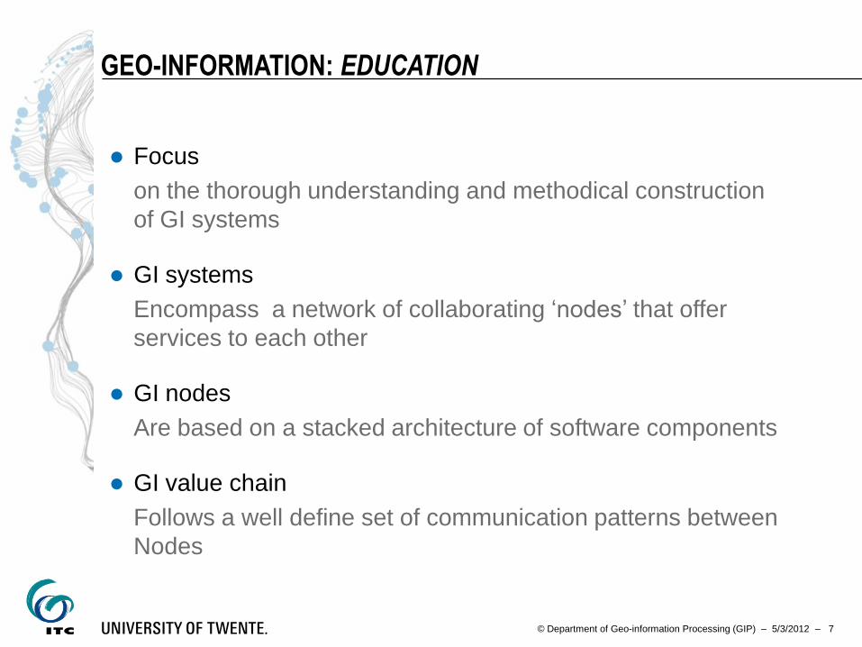
GEO-INFORMATION: EDUCATION
Focus
on the thorough understanding and methodical construction
of GI systems
GI systems
Encompass a network of collaborating ‘nodes’ that offer
services to each other
GI nodes
Are based on a stacked architecture of software components
GI value chain
Follows a well define set of communication patterns between
Nodes
© Department of Geo-information Processing (GIP) – 5/3/2012 – 8
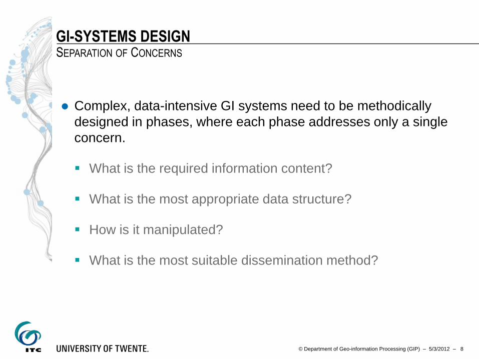
GI-SYSTEMS DESIGN SEPARATION OF CONCERNS
Complex, data-intensive GI systems need to be methodically
designed in phases, where each phase addresses only a single
concern.
What is the required information content?
What is the most appropriate data structure?
How is it manipulated?
What is the most suitable dissemination method?
© Department of Geo-information Processing (GIP) – 5/3/2012 – 10
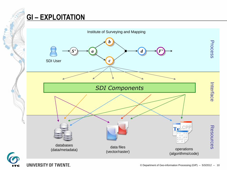
SDI Components
GI – EXPLOITATION
databases
(data/metadata) data files
(vector/raster) operations
(algorithms/code)
a
b
c
F’ d S’
Institute of Surveying and Mapping
Resourc
es
Inte
rface
P
rocess
SDI User
© Department of Geo-information Processing (GIP) – 5/3/2012 – 11
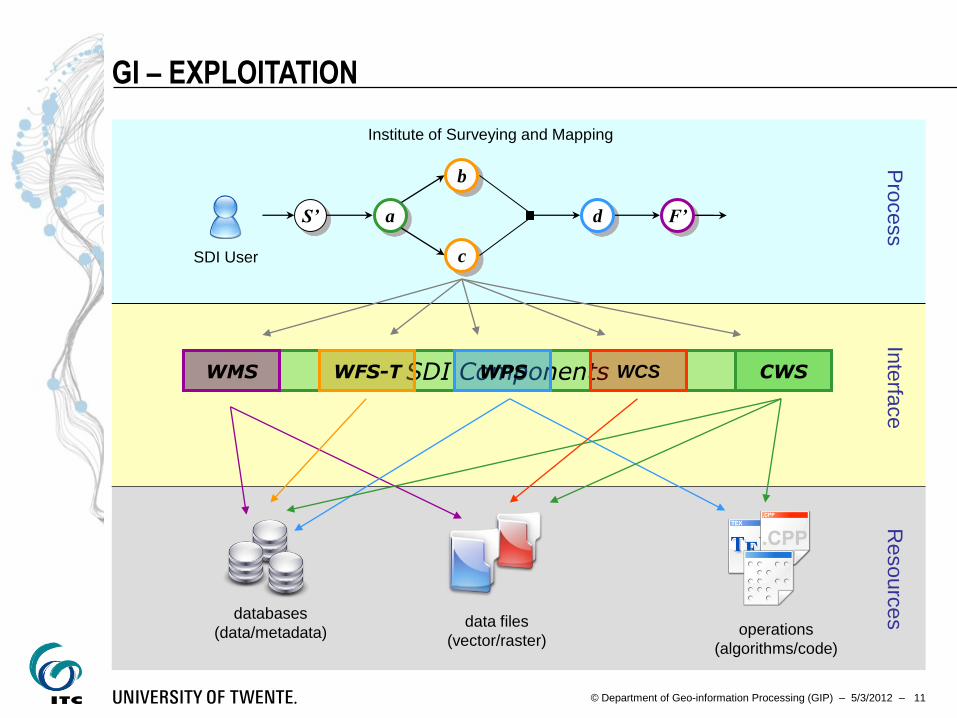
SDI Components
GI – EXPLOITATION
databases
(data/metadata) data files
(vector/raster) operations
(algorithms/code)
a
b
c
F’ d S’
Institute of Surveying and Mapping
Resourc
es
Inte
rface
P
rocess
SDI User
WMS WFS-T WPS WCS CWS

© Department of Geo-information Processing (GIP) – 5/3/2012 – 12
TRANSFORMATIONAL DESIGN

© Department of Geo-information Processing (GIP) – 5/3/2012 – 13
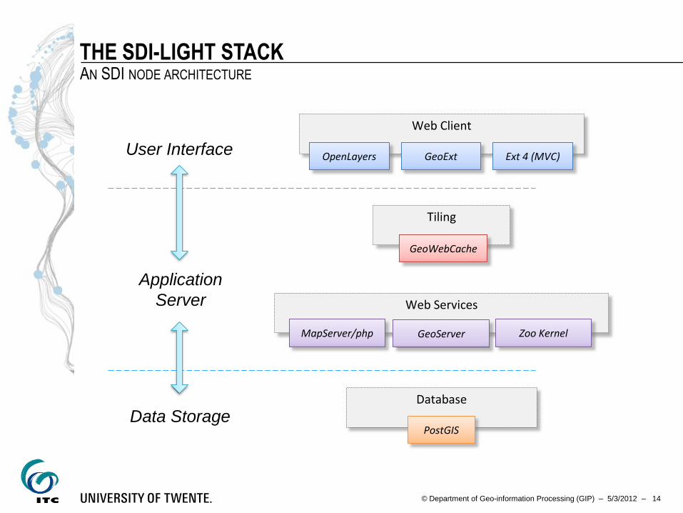
THE SDI-LIGHT APPROACH AN SDI NODE ARCHITECTURE
A spatial database back–end
that stores the spatial data using the OGC Simple Features
A set of interoperable middleware applications
they interface with the database back–end and with each other,
via open service interfaces
Dynamic browser-based clients
Exploiting REST/SOAP services via AJAX requests
© Department of Geo-information Processing (GIP) – 5/3/2012 – 14
THE SDI-LIGHT STACK AN SDI NODE ARCHITECTURE
Database
PostGIS
Tiling
GeoWebCache
User Interface
Application
Server
Data Storage
Web Services
MapServer/php GeoServer Zoo Kernel
Web Client
OpenLayers GeoExt Ext 4 (MVC)
© Department of Geo-information Processing (GIP) – 5/3/2012 – 15
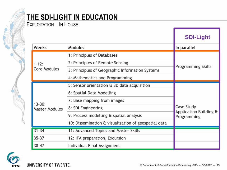
THE SDI-LIGHT IN EDUCATION EXPLOITATION – IN HOUSE
SDI-Light
© Department of Geo-information Processing (GIP) – 5/3/2012 – 16
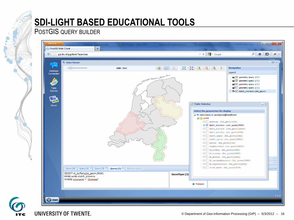
SDI-LIGHT BASED EDUCATIONAL TOOLS POSTGIS QUERY BUILDER
© Department of Geo-information Processing (GIP) – 5/3/2012 – 17
THE SDI LIGHT IN PARTNERSHIPS EXPLOITATION
Firstly,
the strengthening of the capacity of the agencies responsible for the
deployment Geo-informatics curriculum.
Secondly,
together with the agencies, implementing geo–services for their users.
Thirdly,
developing tailor-made applications to address pressing user needs
Finally,
participate actively in a coordinated development of software
components, in the framework of 52°North,
© Department of Geo-information Processing (GIP) – 5/3/2012 – 18
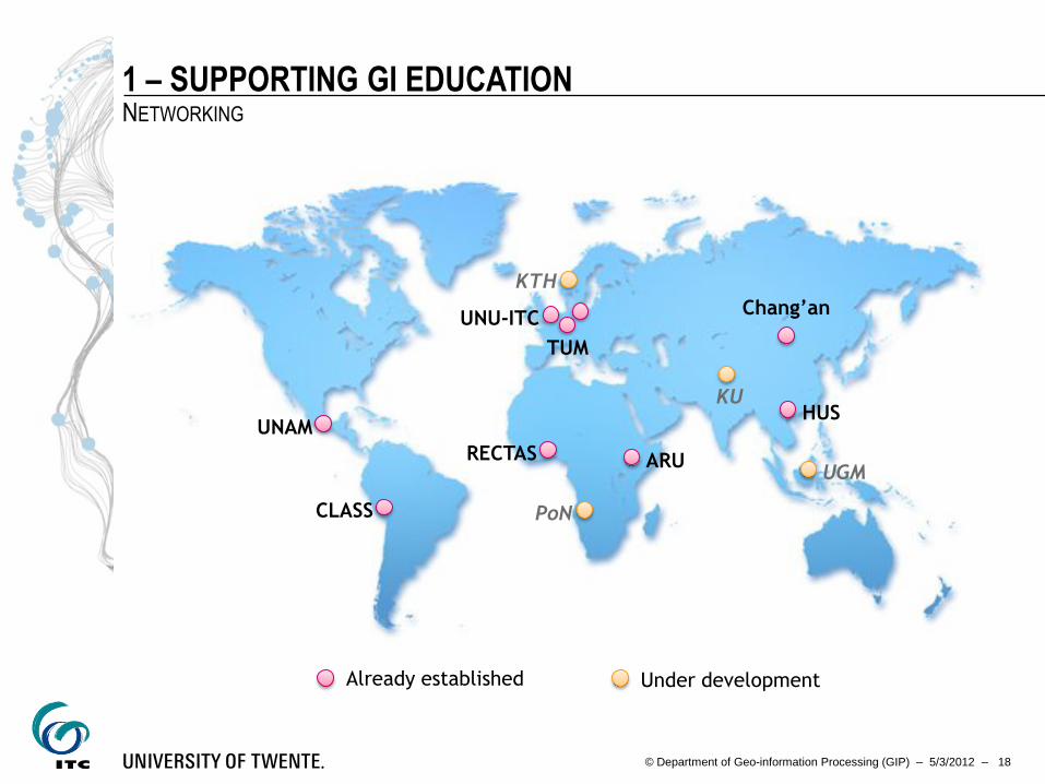
1 – SUPPORTING GI EDUCATION NETWORKING
UNU-ITC
ARU
TUM
Chang’an
HUS
PoN
UGM
KU
KTH
Already established Under development
CLASS
UNAM
RECTAS
© Department of Geo-information Processing (GIP) – 5/3/2012 – 19
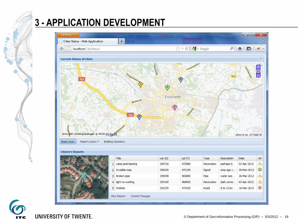
3 - APPLICATION DEVELOPMENT

© Department of Geo-information Processing (GIP) – 5/3/2012 – 20
SDI-LIGHT – SOCIETAL PROCESSES
Cost/Benefit
Analysis Risk Mapping
Risk Financing
Strategies
Land Use Planning
Real time damage
& loss estimation
Climate Impact
Scenarios
SDI-Light

© Department of Geo-information Processing (GIP) – 5/3/2012 – 21
THANK YOU FOR THE ATTENTION
© www.techscreens.com