Oro Moraine Report Card - Lake Simcoe Region … Documents/reports/oro_moraine_2010… · Oro...
8
Oro Mo- raine Report Card – Gen- eral Infor- mation for The Oro Moraine is a prominent natural landform extending northeast from Highway 400 to Orillia. The vast majority of the Moraine lies within Oro-Medonte Township. The west and east tips of the Moraine extend into Springwater Township and the City of Orillia, respectively. The Oro Moraine is approximately 21 km long by 6 km wide and covers an area about 141 km 2 . The Oro Moraine was formed over 12,000 years ago at the terminus of one or more glaciers. Huge volumes of silts, sands and gravels were deposited in this area. As the glaciers retreated, this material was sorted by glacial meltwaters, leaving a legacy of rolling sand and gravel deposits as well as meltwater valleys which cut into the edges of the Moraine. At first European contact in the early 1600s, more than 20,000 Wendats lived in pallisaded villages, growing corn, beans and squash on cleared, sandy fields in North Simcoe. The Rock Tribe (Arendarhonon) lived in villages located between Coldwater and Orillia. The Wendats, already decimated by smallpox, were destroyed in battle by the Iroquois in 1649 and the landscape soon reverted back to forests and wetlands. European settlers in the mid-1800s rapidly altered the landscape. Upland forests were cleared for farming, and areas of droughty soils were found to be unfit for farming and were soon abandoned. Reforestation efforts on these barren lands began in the 1930s and many of these plantations now form part of the Simcoe County forests. Sands and gravels on the Moraine came into demand to facilitate development and a number of areas were developed as borrow pits and, later, as licensed pits. Today, the Oro Moraine is a beautiful pastoral landscape dominated by a mosaic of forest cover, agricultural lands, small patches of residential development, sand and gravel pit operations and commercial recreation uses. The Oro Moraine is the headwaters for watersheds draining west to Nottawasaga Bay, north to Severn Sound and south to Lake Simcoe. Forest cover on the Moraine and wetlands along its base provide important ecological functions and are connected to other natural areas in Simcoe County. Groundwater recharge on the Moraine provides important water supplies for residents. Resurfacing along the flanks of the Moraine, groundwater discharge provides clean, cold baseflow to headwater streams which support sensitive fish species such as brook trout. The Oro Moraine Study Area extends two kilometres outside the Moraine boundary. The wetlands and streams within two kilometres of the Moraine are strongly influenced by groundwater discharge at the base of the Moraine and are integral components of the Moraine ecosystem. Changes in land use in areas next to the Moraine can affect ecosystem functions on the Moraine itself. Oro Moraine Study Area Oro Moraine 2010 Report Card Prepared by: the NVCA & LSRCA on behalf of the Oro-Medonte Environmental Group Advisors B Stream Health B Wetland Conditions A Forest Conditions A Groundwater Grades This report card describes the condition of natural features within the Oro Moraine Study Area and provides stewardship actions to help maintain the health of the area. Other report cards associated with the Moraine can be found on the NVCA, LSRCA and Couchiching Conservancy websites. Nottawasaga Valley Conservation Authority
-
Upload
truongdien -
Category
Documents
-
view
214 -
download
0
Transcript of Oro Moraine Report Card - Lake Simcoe Region … Documents/reports/oro_moraine_2010… · Oro...

Oro Mo-raine Report Card – Gen-eral Infor-mation for
The Oro Moraine is a prominent natural landform extending northeast from Highway 400 to Orillia. The vast majority of the Moraine lies within Oro-Medonte Township. The west and east tips of the Moraine extend into Springwater Township and the City of Orillia, respectively. The Oro Moraine is approximately 21 km long by 6 km wide and covers an area about 141 km2. The Oro Moraine was formed over 12,000 years ago at the terminus of one or more glaciers. Huge volumes of silts, sands and gravels were deposited in this area. As the glaciers retreated, this material was sorted by glacial meltwaters, leaving a legacy of rolling sand and gravel deposits as well as meltwater valleys which cut into the edges of the Moraine. At first European contact in the early 1600s, more than 20,000 Wendats lived in pallisaded villages, growing corn, beans and squash on cleared, sandy fields in North Simcoe. The Rock Tribe (Arendarhonon) lived in villages located between Coldwater and Orillia. The Wendats, already decimated by smallpox, were destroyed in battle by the Iroquois in 1649 and the landscape soon reverted back to forests and wetlands. European settlers in the mid-1800s rapidly altered the landscape. Upland forests were cleared for farming, and areas of droughty soils were found to be unfit for farming and were soon abandoned. Reforestation efforts on these barren lands began in the 1930s and many of these plantations now form part of the Simcoe County forests. Sands and gravels on the Moraine came into demand to facilitate development and a number of areas were developed as borrow pits and, later, as licensed pits. Today, the Oro Moraine is a beautiful pastoral landscape dominated by a mosaic of forest cover, agricultural lands, small patches of residential development, sand and gravel pit operations and commercial recreation uses.
The Oro Moraine is the headwaters for watersheds draining west to Nottawasaga Bay, north to Severn Sound and south to Lake Simcoe. Forest cover on the Moraine and wetlands along its base provide important ecological functions and are connected to other natural areas in Simcoe County. Groundwater recharge on the Moraine provides important water supplies for residents. Resurfacing along the flanks of the Moraine, groundwater discharge provides clean, cold baseflow to headwater streams which support sensitive fish species such as brook trout. The Oro Moraine Study Area extends two kilometres outside the Moraine boundary. The wetlands and streams within two kilometres of the Moraine are strongly influenced by groundwater discharge at the base of the Moraine and are integral components of the Moraine ecosystem. Changes in land use in areas next to the Moraine can affect ecosystem functions on the Moraine itself.
Oro Moraine Study Area
Oro Moraine 2010 Report Card
Prepared by: the NVCA & LSRCA on behalf of the Oro-Medonte Environmental Group Advisors
B Stream Health
B Wetland Conditions
A Forest Conditions
A Groundwater
Grades
This report card describes the condition of natural features within the Oro Moraine Study Area and provides stewardship actions to help maintain the health of the area. Other report cards associated with the Moraine can be found on the NVCA, LSRCA and Couchiching Conservancy websites.
Nottawasaga Valley Conservation Authority

Forest Conditions
Grade
A
Indicators Oro Moraine
Results Indicator Description 5-Year Trend
Forest Cover
50.1 % A Forest Cover is the percentage of the watershed that is forested. Environment Canada suggests that 30% forest cover is the minimum needed to support healthy wildlife habitat — more cover-age is beneficial.
Insufficient Data
Forest Interior
21.36 % A
Forest interior is the area of forest that lies more than 100 m from a forest edge – away from the windy, dry conditions and predators that are associated with the edge. Sensitive forest birds, mammals, reptiles and amphibians require deep forest habitat for survival. Environment Canada suggests that 10% forest interior cover is the minimum needed to support a range of species.
Insufficient Data
Riparian Cover
60.5 % B
Streamside natural cover (riparian vegetation) filters pollutants and provides important fish and wildlife habitat. Environment Canada suggests that at least 30 m on each side of the stream (over 75% of its length) should be in forest cover to support healthy streams.
Insufficient Data
Large intact forest blocks found on the Moraine provide significant habitat for wildlife species which require undisturbed, deep forest habitat (forest interior) to thrive. Maintaining large, connected blocks of forest cover is critical for area-sensitive wildlife that need this type of habitat to survive. The hayfields and grasslands of the Oro Moraine support a number of bird species that require large tracts of open grassland habitat to survive. Several of these species—such as Bobolink, Eastern Meadowlark and Upland Sandpiper—are in steep decline in southern Ontario. The forests and fields of the Oro Moraine support species that are considered to be at risk both provincially and nationally. Forests support Endangered species such as American Ginseng and Butternut and Threatened species including Whip-poor-will. The landscape also supports species of Special Concern such as Milksnake, Red-headed Woodpecker and Common Nighthawk.
Over the past seventy years, reforestation of marginal agricultural lands has increased forest cover on the Moraine. Much of this success is due to the efforts of the Simcoe County Forest program, which recognized the need to protect and reforest the cleared/barren lands in the 1920s. Simcoe County Forests now account for more than 30% of the forested areas within the Oro Moraine. Today, forests cover approximately 50% of the Moraine. Conifer plantation and hardwood maple forests dominate forest cover on the Moraine itself with mixed and conifer swamps present along the flanks of the Moraine. Swamp forest cover provides important winter habitat for deer.

Forest Conditions
Indicators Oro Moraine
Results Indicator Description 5-Year Trend
Stream Health 2.48 B Streams were assessed using a variety of parameters including fisheries, benthic inverte-brates, water chemistry and general stream condition. Healthy streams receive a score of “3” while unhealthy streams receive a score of “1”.
Insufficient Data
Stream Health
Insert Picture
Significant forest cover forms a broad arc from Craighurst through the Copeland Forest and the core of the Moraine northeast to Bass Lake. The east portion of the moraine supports patchier forest cover and is dominated by agricultural land uses. The Copeland Forest is a large provincially significant forest tract located on the steep slopes of the Oro Moraine and headwater valleys of the Sturgeon and Coldwater Rivers. Consisting of a mix of upland and swamp forest, public hiking trails make this area a prime destination for outdoor enthusiasts. Headwater forest cover extending northeast to the Canadian Shield and south to Matheson Creek is an integral part of a natural corridor that extends northeast from the Niagara Escarpment to the east/southeast Canadian Shield. This provincial-scale corridor is highly significant. Forests and wetlands on the Oro Moraine provide critical linkages to natural areas in the Nottawasaga River watershed to the south and west, Lake Simcoe watershed to the east and the south shore of Severn Sound to the north.
Grade
B The Oro Moraine has been divided into six headwater areas for this report. The Willow and Matheson Creek catchments flow south and west toward the Nottawasaga River. The combined Coldwater River/Sturgeon River catchment and North River catchment flow north to Severn Sound. The Hawkestone Creek and Oro Creeks North catchments flow south and east toward Lake Simcoe. The Willow Creek catchment arises on the southwest flanks of the Moraine. Groundwater discharge is relatively weak and headwater tributaries often flow through agricultural landscape with little natural cover. Stream health is generally “fair” with impacts associated with on-stream ponds, channel alterations and livestock access. The Matheson Creek catchment arises on the west and northwest flanks of the Moraine. Strong baseflows, coldwater habitat and “good” stream health characterize most of the headwater tributaries and brook trout are common. Most of these tributaries flow through forested landscapes and remain unaltered by human impacts. Streams with “fair” health may be impacted by on-stream ponds, sparse streamside habitat and/or highway impacts – Highway 400 crosses all catchment tributaries.
Grade
A

Stream Health Grade
B The headwaters of the Sturgeon River arise within the northwest corner of the Moraine study area. Headwater tributaries flow through forest and wetland cover and are considered in “good” health. The Coldwater River catchment dominates the north-central portion of the Oro Moraine. Incised tributary valleys cut into the Moraine, receiving substantial groundwater inputs. Flowing through natural landscapes, these tributaries exhibit “good” stream health and typically support brook trout. The northeast portion of the Oro Moraine drains toward Bass Lake which, in turn, feeds the North River system. Similar to Coldwater Creek, incised valleys cut into the Moraine and associated tributaries have strong, cold flows which often support brook trout. “Good” stream health in the headwaters of these tributaries often becomes degraded to “fair” toward Bass Lake as a result of on-stream ponds and stream alterations (ditching). The Oro Creeks North catchment arises along the southeast flanks of the Oro Moraine. Bluff’s Creek and Mill Creek originate in headwater wetlands. Groundwater inputs provide coldwater conditions that support sensitive species such as brook trout and mottled sculpin. Stream health is generally “good”. Impacts (and “fair” health) are associated with on-stream ponds and sparse streamside habitat through agricultural areas. The Hawkestone Creek catchment arises along the southeast flanks of the Oro Moraine. Hawkestone Creek and its tributaries originate in headwater wetlands. Groundwater inputs provide coldwater conditions that support sensitive species such as brook trout and mottled sculpin. Stream health is “good” throughout the study area. Overall, stream health is generally good within the Oro Moraine study area. Strong groundwater inputs along the flanks of the Moraine support coldwater habitat. Brook trout are found in many tributaries. Sources of impairment include: on-stream ponds, sparse streamside vegetation and stream alteration (ditching). Urban land uses, agricultural uses and recreation (golf courses) are associated with these impairments.
Stream pic-ture

Wetland Conditions Grade
B
Indicators Oro Moraine Results Indicator Description Trend
Wetland Cover 13.05 % A 10% wetland cover has been identified as a minimum guideline for healthy watersheds (Environment Canada).
Insufficient Data
Wetland Buffer (100m buffer area) 46.6 % C
A buffer is a vegetated area next to a wetland or stream. Many wildlife species require adjacent upland areas for foraging, nesting and other activities.
Insufficient Data
.
High, rolling terrain combined with sandy/gravelly soils results in very low wetland coverage on the Oro Moraine itself. However, extensive groundwater discharge (seeps and springs) along the flanks of the Moraine support provincially significant wetlands—many of which form the headwaters of coldwater streams. Headwater wetlands provide natural flood control along the flanks of the Moraine. Marsh and swamp (wooded) wetlands provide important habitat for a wide range of wildlife including wintering habitat for white-tailed deer. Groundwater discharge from many of these flanking wetlands contribute cold water flow to headwater streams which support brook trout and other sensitive coldwater species. Groundwater recharge in some wetlands maintains groundwater supplies. Wetland cover along the flanks of the Moraine is generally high. Some historic loss is associated with conversion to agricultural and urban land uses. Upland buffers next to wetlands are important for many species of wildlife such as waterfowl and woodland amphibians. The extent of these buffers is variable within the study area. There will be some loss of buffers in the Coulson area as a result of estate residential development approved through past planning decisions. Five wetland groupings within the Oro Moraine have been identified as provincially significant by the Ontario Ministry of Natural Resources. Provincial and municipal planning policies protect these wetlands from development and site alteration.
Groundwater Insert Picture
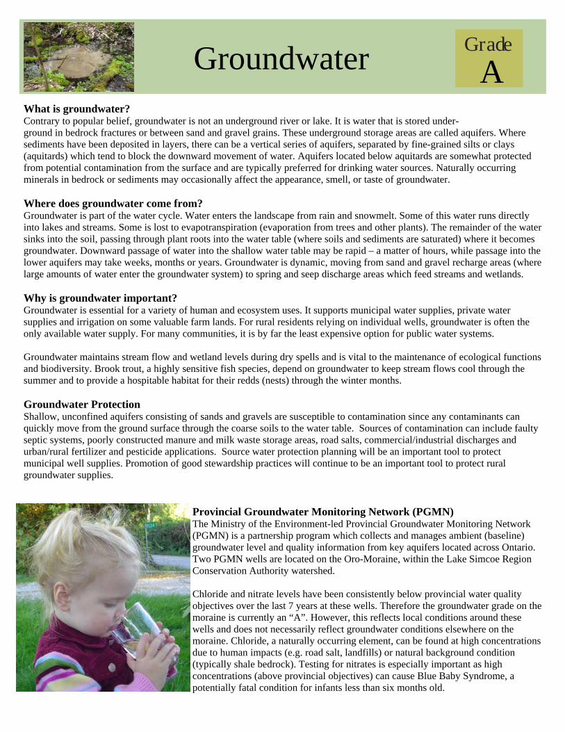
What is groundwater? Contrary to popular belief, groundwater is not an underground river or lake. It is water that is stored under-ground in bedrock fractures or between sand and gravel grains. These underground storage areas are called aquifers. Where sediments have been deposited in layers, there can be a vertical series of aquifers, separated by fine-grained silts or clays (aquitards) which tend to block the downward movement of water. Aquifers located below aquitards are somewhat protected from potential contamination from the surface and are typically preferred for drinking water sources. Naturally occurring minerals in bedrock or sediments may occasionally affect the appearance, smell, or taste of groundwater. Where does groundwater come from? Groundwater is part of the water cycle. Water enters the landscape from rain and snowmelt. Some of this water runs directly into lakes and streams. Some is lost to evapotranspiration (evaporation from trees and other plants). The remainder of the water sinks into the soil, passing through plant roots into the water table (where soils and sediments are saturated) where it becomes groundwater. Downward passage of water into the shallow water table may be rapid – a matter of hours, while passage into the lower aquifers may take weeks, months or years. Groundwater is dynamic, moving from sand and gravel recharge areas (where large amounts of water enter the groundwater system) to spring and seep discharge areas which feed streams and wetlands. Why is groundwater important? Groundwater is essential for a variety of human and ecosystem uses. It supports municipal water supplies, private water supplies and irrigation on some valuable farm lands. For rural residents relying on individual wells, groundwater is often the only available water supply. For many communities, it is by far the least expensive option for public water systems. Groundwater maintains stream flow and wetland levels during dry spells and is vital to the maintenance of ecological functions and biodiversity. Brook trout, a highly sensitive fish species, depend on groundwater to keep stream flows cool through the summer and to provide a hospitable habitat for their redds (nests) through the winter months. Groundwater Protection Shallow, unconfined aquifers consisting of sands and gravels are susceptible to contamination since any contaminants can quickly move from the ground surface through the coarse soils to the water table. Sources of contamination can include faulty septic systems, poorly constructed manure and milk waste storage areas, road salts, commercial/industrial discharges and urban/rural fertilizer and pesticide applications. Source water protection planning will be an important tool to protect municipal well supplies. Promotion of good stewardship practices will continue to be an important tool to protect rural groundwater supplies.
Provincial Groundwater Monitoring Network (PGMN) The Ministry of the Environment-led Provincial Groundwater Monitoring Network (PGMN) is a partnership program which collects and manages ambient (baseline) groundwater level and quality information from key aquifers located across Ontario. Two PGMN wells are located on the Oro-Moraine, within the Lake Simcoe Region Conservation Authority watershed. Chloride and nitrate levels have been consistently below provincial water quality objectives over the last 7 years at these wells. Therefore the groundwater grade on the moraine is currently an “A”. However, this reflects local conditions around these wells and does not necessarily reflect groundwater conditions elsewhere on the moraine. Chloride, a naturally occurring element, can be found at high concentrations due to human impacts (e.g. road salt, landfills) or natural background condition (typically shale bedrock). Testing for nitrates is especially important as high concentrations (above provincial objectives) can cause Blue Baby Syndrome, a potentially fatal condition for infants less than six months old.
Grade
A

Groundwater
Stewardship
Insert picture
Oro Moraine Aquifers The thick layers of sands and gravels underlying the moraine are separated by clay/silt aquitards, resulting in the formation of four distinct aquifers. The relatively unconfined Upper Aquifer is continuous throughout the Oro Moraine and is associated with a deep water table, where water lies far below the ground surface. The Regional Aquifer is commonly used for private water supplies as well as for municipal water supply wells. This aquifer is also fairly continuous throughout the Oro Moraine. The Lower Drift and Basal Gravel aquifers are deep aquifers and are of limited extent in the Oro Moraine area.
For additional information on Invasive Species, Prevention Techniques and Control Methods visit: Ontario Federation of Anglers and Hunters (OFAH) http://www.ofah.org or Ontario Nature http://www.ontarionature.org
Grade
A
Whether you are a landowner or a visitor, you can do your part to keep the Oro Moraine healthy and vibrant by being a good steward. Here are a few tips on how you can do your part! Invasive Species Invasive species are organisms that have been introduced into areas where they haven’t historically existed, and often lack natural predators to help control their spread. Invasive species can cause harm to native species damaging ecosystems and threatening biodiversity. While some invasive, non-native species have already been introduced to the Moraine, the need for vigilance is high in order to prevent other undesirable species from becoming established. While control methods may seem labour intensive, a healthy, biologically diverse moraine will be worth the effort!
General Rules of Etiquette for Shared Use Trails Give the right-of-way to smaller and slower users. Stay right when approaching oncoming users. Stay on the trail surface. Don’t make new trails or use unmarked trails. Keep pets on a leash and clean up after them. Obey signs. Do not climb fences or take shortcuts. Respect the privacy of landowners bordering the trails & avoid excessive noise. Leave wildlife and plants for others to enjoy. Be aware of and adhere to only permitted uses along the trail. For guidelines for your specific form of trail use, please visit ‘Simcoe County Trails—Ready to Explore!’ at: www.simcoecountytrails.net/home/userguidelines.htm.

Stewardship Septic Systems Inspect and maintain your tank—have it pumped every 2 to 3 years Do not dump toxic waste, fats/oils, or antibacterial products down your drain or toilet Have an effluent filter installed in your septic tank to prevent solids from clogging your system Avoid constructing decks or patios or watering your lawn around the leaching bed; shade and excess
water can reduce the bed’s ability to absorb and treat wastewater from your house Use phosphate-free or low phosphate detergents and cleaners Drinking Water / Well Care Ensure your well is a minimum of 30m (100’) from your - and your neighbours’- septic bed Test your drinking water for bacteria at least 3 times a year - test bottles can be obtained from your local health unit Use less water to decrease the amount of water filtering through your septic system and the amount of nutrients or pollut-
ants that seep into the groundwater Clean debris from around your well and ensure the lid is vermin proof Managing a Healthy Woodlot Plant additional native trees to reestablish valuable natural corridors between forested areas Develop a natural stewardship plan for your property Ensure the long term protection of your woodlot - consider land donation to a conservation organization (visit
www.couchichingconservancy.ca for more information). Plant native buffers around smaller woodlots to increase forest interior and to help reduce the spread of invasive species Develop a managed forest plan to ensure that you are logging your woodlot sustainably (For more information on the
Ontario Managed Forest Tax Incentive Program (MFTIP) visit www.ont-woodlot-assoc.org) Healthy Streams, Wetlands and Forests Protect and restore forest and wetland cover, streambanks, and shorelines to maintain
and enhance natural habitats and corridors Restore forest and meadow cover next to wetlands and streams to improve wildlife
habitat and stream/wetland health Manage plantations with a goal of restoring native forest cover over time Work with landowners to reduce impacts of on-stream ponds, and shoreline/streambank erosion Work with farmers, municipalities, developers, golf courses, and others to manage nutrients by:
keeping cattle out of streams, implementing nutrient management plans, managing urban stormwater runoff and controlling sediment on construction sites
Partnerships and Additional Resources Thanks to all of our Moraine Champions—our landowners, community groups, schools,
businesses and government agencies—that support stewardship activities on the moraine!
For more information or to get involved, contact the NVCA at (705) 424-1479 www.nvca.on.ca or the LSRCA at (905) 895-1281 www.lsrca.on.ca The Couchiching Conservancy www.couchconservancy.ca (705) 326-2620 Township of Oro-Medonte www.oro-medonte.ca (705) 487-2171 Severn Sound Environmental Assoc. www.severnsound.ca (705) 527-5166 Ministry of Natural Resources www.mnr.gov.on.ca (800) 667-1940 Simcoe-Muskoka Health Unit www.simcoemuskokahealth.org(877)721-7520
Nottawasaga Valley Conservation Authority