Orial Kryeziu Sea Surface Diurnal Warming
14
Sea Surface Diurnal Warming Diurnal Warming: sub-daily variations in sea surface temperature (SST) defined relative to the temperature prior to diurnal stratification (foundation temperature). Therefore, define dSST as the SST during the day minus foundation temperature usually pre-dawn SST (before heating commences). During the day, the upper few meters of the ocean experience thermal stratification due to short-wave solar radiation. At night, the water column will usually cool from the surface. The daily progression in heating and cooling gives a diurnal cycle in SST. Aim: It is well known that surface wind stress plays an important role in diurnal stratification on time-scales of hours to days. Here we explore the correlations in spatial variations in the wind field and the spatial variability in mean or maximum dSST over the study period. Orial Kryeziu
Transcript of Orial Kryeziu Sea Surface Diurnal Warming

Sea Surface Diurnal Warming
Diurnal Warming: sub-daily variations in sea surface temperature (SST) defined relative to the temperature prior to diurnal stratification (foundation temperature). Therefore, define dSST as the SST during the day minus foundation temperature usually pre-dawn SST (before heating commences).
During the day, the upper few meters of the ocean experience thermal stratification due to short-wave solar radiation. At night, the water column will usually cool from the surface. The daily progression in heating and cooling gives a diurnal cycle in SST.
Aim: It is well known that surface wind stress plays an important role in diurnal stratification on time-scales of hours to days. Here we explore the correlations in spatial variations in the wind field and the spatial variability in mean or maximum dSST over the study period.
Orial Kryeziu

Why is sea surface diurnal warming important? Top 5 m of the ocean are responsible for absorbing 60% of the incoming solar radiation (Fairall et al., 1996). Important in ocean and atmosphere modelling:
● Ocean forecasting models need SSTs of the model's top layer (see Stark et al.,2007).
● Diurnally-varying SST rather than daily averaged SST affects air-sea fluxes and convection in modelling studies of the tropical Pacific (Haman and Clayson , 2007).
● Improve coherency and forecasts of coupled ocean-atmosphere models e.g. Madden Julian Oscillation (Bernie et al., 2008). (fundamental contributions can be made to the understanding of the coupled ocean atmosphere system)
Factors influencing diurnal warming:
● Net heat flux during the day associated with the daily cycle in solar heating.
● Wind speed.
● The temperature and salinity of the water.
● The optical attenuation coefficient of the water.
● Mixing from the wave motions.

3
- The SST data are hourly observations by SEVIRI spanning -100°W to 45°E and -60°S to 60°N mapped on a 0.05° resolution grid. Currently, data is available for one month: June 2006. Also available from SEVIRI is the “Saharan dust index” (SDI)- non-dimensional index based on infra-red wavelengths. - Peak-to-peak mean amplitude in dSST for the ocean as whole is 0.25 K. Largest dSSTs exceed 6K, and affect 0.01% of the surface.

4
Winds fields (ERA-interim) derived from a numerical prediction model (NWF) are obtained from ECMWF. The winds in the western Mediterranean and European Seas are heavily defined by land-sea contrasts and orographic effects. Diurnal warming cases occur frequently in this region.The picture shows the mean of the reciprocal of the wind speed between 0900 and 1500 h UTC.

5
Mean maximum value of dSST here shows correlation with the mean reciprocal of the wind strength. It is useful to consider knowledge of frequent local wind fields to see orographic influences on diurnal variability. For example:- Surface winds accelerated through the Corsica and Sardinia passage (Merchant et al. 2008).- Mistral winds are often responsible for the clear, sunny weather in the Golfe du Lion.
Mistral Wind

6
14th of June 2006
A few examples of dSST>4:

7
3rd of June 2006

8
D(t)=Q(t )( a(t )
1+b (t )W 2(t )
+c (t ))
A statistical model for sea surface diurnal warming
Functional form:
D(t) – Difference between the SST at time t and the reference temperature
Q(t) – Integrated net heat flux since it became positive (near dawn).
W(t) – Maximum wind speed since net heat flux became positive.
Empirical model relating the diurnal variation of SST to the net surface heat flux and surface wind speed (Filipiak et al. 2012).

9
Frequency matching
Direct frequency matching for 14:00 LT
Frequency of wind speed < W, as a function of W
Frequency of warming > D, as a function of D
Hypothesis: at a given time of day and for equal integrated heat flux, D is a function of W (low W will give large D).

10
Results of direct frequency matching, for 14:00 LT
Warming D as a function of QW ranges from 1 to 10 m/s
Warming D as a function of WQ ranges from 4.2 to 17 MJm**-2
11
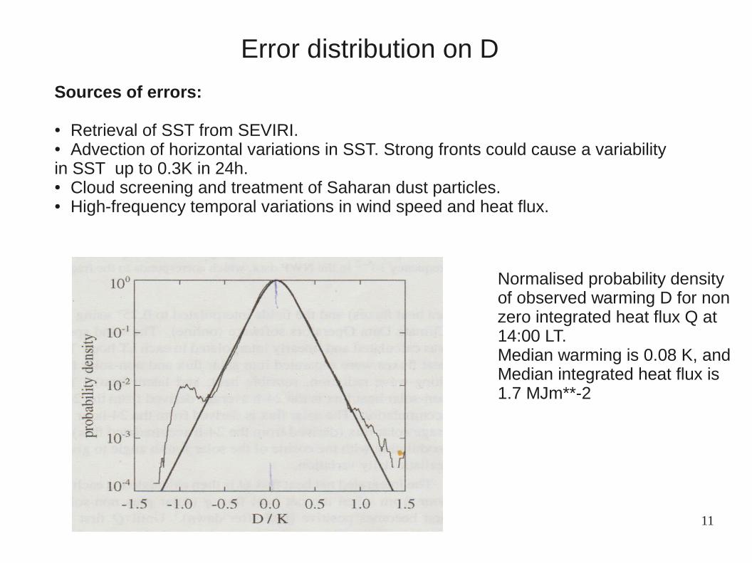
Error distribution on D
Sources of errors:
● Retrieval of SST from SEVIRI.● Advection of horizontal variations in SST. Strong fronts could cause a variability in SST up to 0.3K in 24h.● Cloud screening and treatment of Saharan dust particles. ● High-frequency temporal variations in wind speed and heat flux.
Normalised probability densityof observed warming D for nonzero integrated heat flux Q at 14:00 LT.Median warming is 0.08 K, andMedian integrated heat flux is1.7 MJm**-2
12
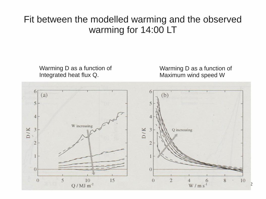
Warming D as a function of Integrated heat flux Q.
Warming D as a function ofMaximum wind speed W
Fit between the modelled warming and the observed warming for 14:00 LT

13
Validation of the model
Statistics of D averaged over SEVIRIarea.
Day-night difference in SST at AMSR-ELocations and times, averaged over June 2006-May 2007.
Model is tested by comparing its statistical predictions of diurnal warming during 2006-2007 over:● SEVIRI area (55°W-45°E,50°S-50°N)● Globally, Advanced Microwave Scanning
Radiometer (AMSR-E) observations.

Conclusions:
● Extreme diurnal events (peak dSST > 4K) are observed by SEVIRI.
● In the Mediterranean sea orographic influence is an important factor. In the North and Baltic Seas, optical attenuation coefficient of water is a (significant ) driving factor.
● Sustained low winds are required for extreme warming events to be observed.
● The statistical model does reproduce the statistics of the observed warming, including large values (>3K).
● The model can be used for testing more physical based models (see Bellenger and Duvel 2009) .
Thank You