OREGON STATE UN VERSITY IBRARIES NAVIGATION on the ...
30
OREGON STATE UN VERSITY IBRARIES 12 0143685010 NAVIGATION on the COLUMBIA RIVER LIGHTHOUSE AT NORTH HEAD (Cape Disappointment) Corps of Engineers U.S. Army Portland, Oregon, District 1941
Transcript of OREGON STATE UN VERSITY IBRARIES NAVIGATION on the ...
OREGON STATE UN VERSITY IBRARIES
12 0143685010 NAVIGATIONon the
COLUMBIA RIVER
LIGHTHOUSE AT NORTH HEAD (Cape Disappointment)
Corps of EngineersU.S. Army
Portland, Oregon, District1941
NAVIGATIONON THE
COLUMBIA RIVER
TABLE OF CONTENTS
Page
Description 1
History 3
Surveys and charts 7Impnvements at the mouth 8
River improvements - Portland to the Sea 9
Navigation above Vancouver 13Present river traffic 20
River terminals 21
The effect of navigation improvernts upon industrial development 22
Resume 23
Mileage Tables 24
PHOTOGRAPHS
Entrance to Columbia River 6Columbia River at Vancouver, Washington 11
Willamette River at Portland, Oregon 12
1+. Bonneville Dam 18
5. Oil barge in Bonneville Lock 19
PLATES
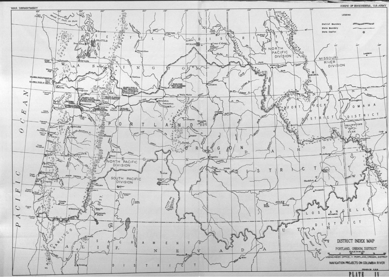
I Captain George Vancouvers chart - 1798II Lap of Columbia River to Snake River - 1841III Mouth of Columbia River - 1941IV Navigation Projects on Columbia River
NAVIGATIONON THE
COLUMBIA RIVER
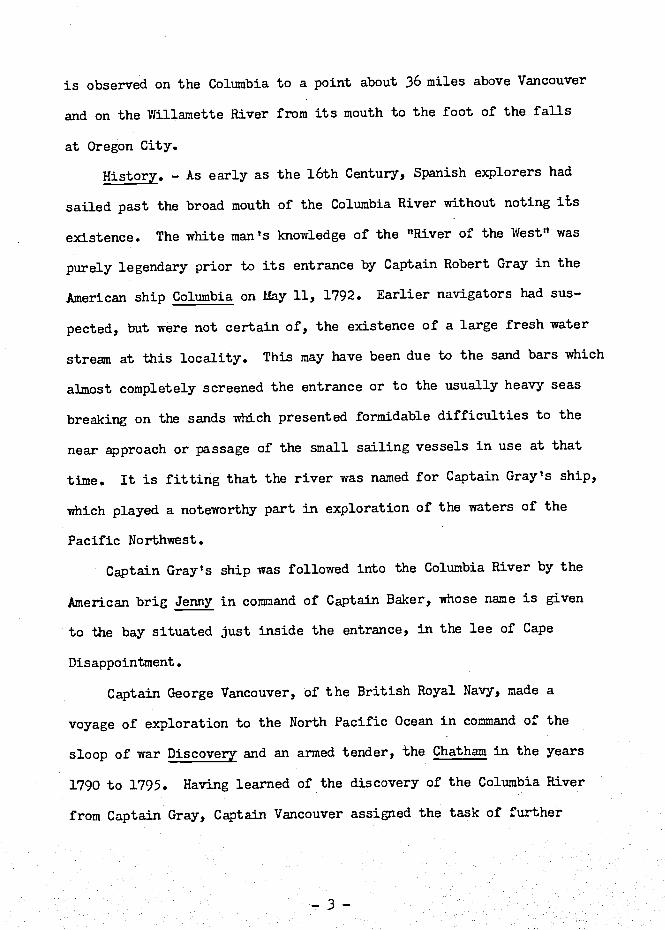
Description. - The Columbia River Basin extends from the Conti-
nental Divide to the Pacific Ocean and lies between the rugged moun-
tains of British Columbia and the arid regions of Utah and Nevada.
The river is 1,210 miles in length and with its tributaries drains
an area of 259,000 square miles. From its source in British Columbia,
75 miles north of the International Boundary, the Columbia River
flows northwesterly for 200 miles, then turns arid flows almost due
south a distance of 260 miles, entering the United States near the
northeastern corner of the State of Washington. From the Interna-
tional Boundary, the river flows in a general southerly direction
a distance of 441 miles through the eastern part of the State of
Washington and thexf turns and flows westward 309 miles between the
States of Oregon and Washington to the Pacific. Snake River, the
largest tributary, enters the Columbia in Washington just north of
the Oregon boundary (See Plate IV).
The Columbia River breaks through the Cascade Range of mountains
in a spectacular gorge having a width, from rim to rim, of one to two
miles. Basaltic cliffs rise precipitously to heights of more than
3,000 feet above the river channel. In early day voyages, portages
at the numerous rapids were necessary, but improvements which have
been made have eliminated most of the natural obstructions to navi-
gation on the Columbia River, from its mouth deep into the Inland
Enpire.
The river empties into the Pacific Ocean 583 miles north of San
Francisco Bay and 153 miles south of the Strait of Juan de Fuca. Cape
Disappointhent, a high, rocky headland lies to the north, and Clatsop
Spit, a low sand point, to the south of the entrance. Glatsop Spit
extends a distance of 2-1/2 miles northwesterly from Point Adams, the
original mainland, at the southerly side of the entrance. The distance
between Point Adams and Cape Disappointment is about 6 miles.
Snake River has a drainage area of 109,000 square miles. It rises
in Yellowstone National Park in Western Wyoming, flows westerly across
Idaho and northerly along the boundary between the States of Oregon and
Idaho to Lewiston, Idaho, thence westerly across the southeast corner
of the State of Washington to its mouth. Other important tributaries
above the mouth of the Snake include the Clark Fork, which drains a
large area in Western Montana and enters the main stream near the In-
ternationaJ. Boundary; the Kootenal, which lies largely in Canada and
enters the Columbia from the northeast some 30 miles above the Inter-
national Boundary; and the Spokane, Okanogan, Chelan, and Yakinia Rivers.
The important tributaries of the Columbia River below the Snake are the
Walla WaUa River in Oregon and Washington, the Umatila, John Day,
Deschutes, and Wiflamette Rivers in Oregon, and the Klickitat, White
Salmon, Lewis, and Cowlitz, in Washington.
The extreme low-water flow of the Columbia above the mouth of
the Willamette River is about 50,000, and the maximum discharge of
record about 1,160,000 cubic feet per second. The effect of the tides °
is observed on the Columbia to a point about 36 miles above Vancouver
and on the Willainette River from its mouth to the foot of the falls
at Oregon City.
History. - As early as the 16th Century, Spanish explorers had
sailed past the broad mouth of the Columbia River without noting its
existence The white man 's knowledge of the "River of the West" was
purely legendary prior to its entrance by Captain Robert Gray in the
Merican ship Columbia on May 11, 1792. Earlier navigators had sus-
pected, but were not cert.ain of, the existence of a large fresh water
stream at this locality. This may have been due to the sand bars which
almost completely screened the entrance or to the usually heavy seas
breaking on the sands which presented formidable difficulties to the
near approach or passage of the small sailing vessels in use at that
time. It is fitting that the river was named for Captain Gray's ship,
which played a noteworthy part in exploration of the waters of the
Pacific Northwest.
Captain Gray's ship was followed into the Columbia River by the
American brig Jenny in command of Captain Baker, whose name is given
to the bay situated just inside the entrance, in the lee of Cape
Disappointment.
Captain George Vancouver, of the British Royal Navy, made a
voyage of exploration to the North Pacific Ocean in command of the
sloop of war Discovery and an armed tender, the Chatham in the years
1790 to 1795. Having learned of the discovery of the Columbia River
from Captain Gray, Captain Vancouver assigned the task of further

exploration to Lieutenant W. R. Broughton, who proceeded in a small
boat to Vancouver Point, site of the present city of Vancouver, Wash..-
ington in the fall of 1792. On this voyage of exploration, names were
assigned to a number of streams and land marks, a few of which have
survived. Among these are: Youngs River, Tongue Point, Grays Bay,
Puget Island, Walker Island, Mt. Coffin, Warrior Rock, Vancouver, and
Mt. Hood.
By 1796, a number of ships engaged in the fur trade were making
the estuary of Columbia River a regular port of call. Lewis and C1ark
entering upon the last lap of their westward journey of exploration in
1805 reached the Clearwater River, which they followed to its junction
with the Snake, thence down the Snake River to the Columbia, The des-
cent of the Columbia River to its mouth was made in canoes, portages
being made at the numerous rapids. The journal of Lewis and Clark is
the first authentic record of navigation on the Columbia River above
Vancouver by white men, though French trappers and fur traders had
previously operated their bateaux in the upper reaches of the stream
The settlement of Astoria had its beginning upon the arrival of
John Jacob Astor's ship, the Tonquin on March 24, l8U. The first
steam-propefled craft to enter the river was the Hudson Bay Company's
Beaver, in 1836. The Oregon legislature passed a law in 1846 author-.
izing the governor to appoint a pilot commission. In April, 1847,
the first pilot's license on the Columbia River was granted and shortly
thereafter coastwise shipments of lumber began, stimulated by the
discovery of gold in California in 1849. Four years later, the first
cargo of export lumber was shipped, from Portland, Oregon, to Australia.
During this period, vessels of about 20-foot draft could enter the
river in its unimproved condition, though the crossing was hazardous
on account of the shifting nature of the channels in the wide bar at
the mouth.
The first river-type steamer to ply the Columbia was a 90-foot
side-wheel vessel named the Columbia. She was built at Astoria and
made her initial trip on July 3, 1850. Shortly afterward, the 160-
foot Lot lThitcomb was placed in service. These two pioneer river
steamers plied between Astoria and Vancouver on the Columbia and to
Oregon City on the Willamette. The freight rate between Astoria and
the upper settlements on these first vessels was $25 per ton and the
fare $25 per passenger.
A Coast Survey chart of the entrance was prepared in 1851, and
in October 1856 the lighthouse on Cape Disappointment was completed.
The year 1868 marks the first direct shipments of wheat in the export
trade from Portland, and by 1874 there were 85 ships in the grain fleet
out of Portland, the largest having a tonnage of 1,346 and the smallest
291.
Two of the largest warships in the American Navy, the cruisers
Baltimore and Charleston (4,600 and 4,044 tons, respectively), ascended
the river to Portland in 1892, 100 years from the date of discovery.
These were the largest vessels to enter the river up to that time, and
it was stated by their conunanders that the Columbia was the only,, stream
in America which their vessels could ascend for 100 miles.

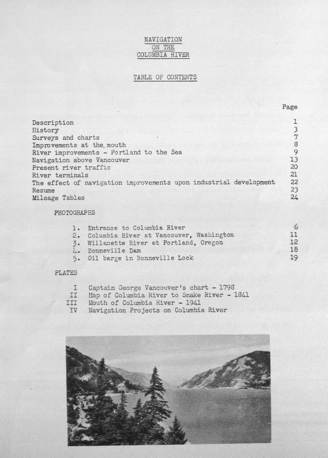
Photo No. 1. ENTRANCE TO COLUMBIA RIVER.Showing North and South jetties.Cape Disappointment in foreground.
6
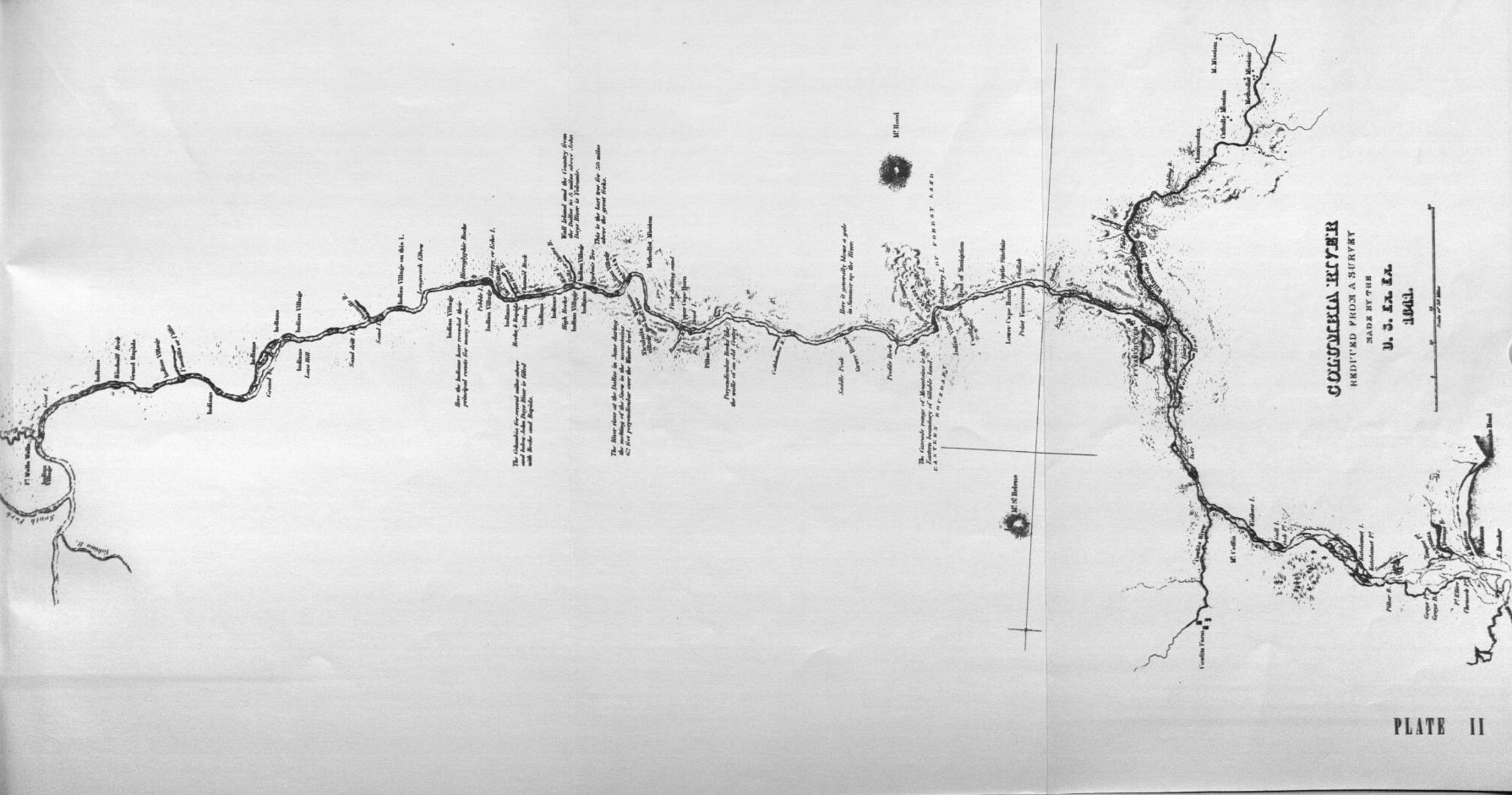
Surveys and charts. - The first published chart of the waters of
the Pacific Northwest is that prepared from the records of Captain
George Vancouver's voyage of exploration and discovery, 1790 to 1795.
On this early chart an insert shows, in some detail, the estuary of the
Columbia River. Soundings and other data were obtained, no doubt from
the records of Lieutenant Broughton, who made a vpyage up the Columbia
River as far as Vancouver. (See Plate I). It has been stated that
William A. Slacum of the U. S. Navy made a survey of the estuary in 1836
under the direction of President Jackson, though no charts of this sur-
vey have been found. Sir Edward Beicher, of the British Admiralty, sur-
veyed the entrance in considerable detail in 1839, and copies of the
chart prepared from this survey are available. The next survey was made
in 1841 by Captain Charles Wilkes, who was in command of the U. S. Ex
Ex. The Wilkes expedition also mapped the Columbia River as far as the
mouth of the Snake River and many interesting notations are to be found
on this map. (See Plate II).
The first chart of the U. S. Coast Survey bears the date of 1851.
Beginning in 1875, and excepting the years 1877, 1884, 1887, and 1888,
surveys of the entrance have been made annually by the Corps of Engi-
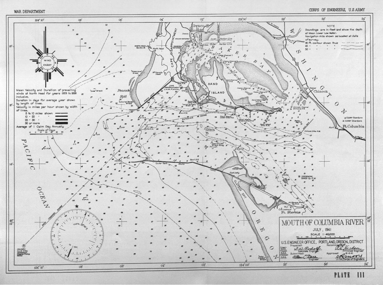
neers, United States rxny. The 1941 survey is shown on Plate III.
The execution of the Federal river and harbor and power projects re-
ferred to in the foflowing paragraphs, except Grand Coulee, has been
carried out by the Corps of Engineers.
Improvements at the mouth. - Originally there were from one to
three channels across the bar at the mouth of the Columbia, shifting
rapidly in location and with depths of only 19 to 21 feet. Navigation
improvements at the mouth of the river were inaugurated by the River
and Harbor Act of July 5, 1884. This act provided for the construction
of a south jetty extending seaward from Point Adams, a distance of 4-
1/2 miles Construction operations for this first improvement extended
from April 1885 to October 1895. Extensions of the south jetty, which
have since been made have provided a structure with a total length of
about 7 miles and as rehabilitated in 1932-35 is now about 26 feet in
height above low water and contains about 8,000,000 tons of rubble
stone. Construction of a concrete terminal extending 1200 feet shore-
ward from the outer end, to prevent ravelling of the enrocknient, is
now under way. Construction of the north jetty was authorized by the
River arx3. Harbor Act of March 3, 1905. However, work was not begun
until 1913 and the jetty was completed in 1917.
The existing Federal project provides for a channel 40 feet deep
and not less than one-half mile wide over the ocean bar. The improve-
ments have resulted in a stabilized channel with a present depth of
46 feet at mean lower low water on the entrance range, and depths of
/0 feet and over prevailing over a width of about one mile (See Plate
III). No dredging has been necessary since 1918.
Expenditures for new work and maintenance at the mouth of the
Columbia River to June 30, 1941, have amounted to $22,531,320.83.
In addition, local interests have contributed $500,000 for new work.
River improvements, Portland to the Sea. - In 1853, Portland was
a small village struggling for existence. Shipping was continually
being held up on account of the troublesome bars in illamette River
below Portland arid in Columbia River above St Helens Steamers would
occasionally ground on the bars below St. Helens but were usually able
to free themselves at high tide. On account of these conditions some
of the vessels engaged in regular service made St. Helens their up
stream terminus on the Columbia, and a considerable part of the com-
merce in these early days was moved from the vicinity of Portland on
lighters to points on the lower river.
Increased use of the river by ships in foreign and coastwise trade
arid the growing importance of Portland as a commercial center resulted
in the adoption in 1877 of a project 'thich provided for a channel depth
of 20 feet between Portland and the sea. Prior to the adoption of the
original project, however, expenditures of some $222,000 for dredging
to provide temporary, relief had been made. In 1891, the project was
revised to obtain a low-water channel depth of 25 feet at an estimated
cost of $772,464, and the Port of Portland Commission was granted per-
mission to assist in carrying out the execution of the project. The
Act of July 25, 1912, provided for increasing the main channel depth
to 30 feet.
The existing Federal project authorized by the Act of July 3, 1930,
provides for a 35-foot depth in a channel 500 feet wide from Portland t0
the sea, and a channel 300 feet wide and 30 feet deep from Vancouver to
the mouth of the Willamette River (5 miles), together with turning
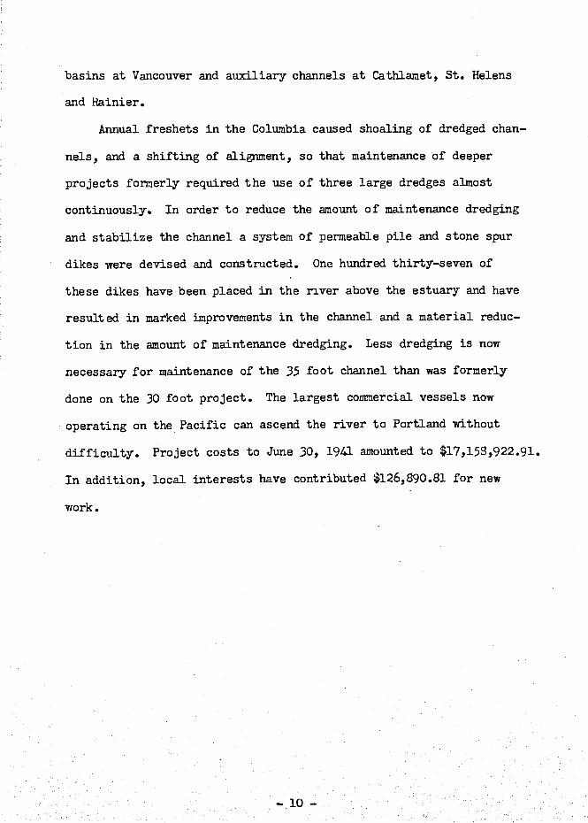
basins at Vancouver and auxiliary channels at Cathianiet, St. Helens
and Hainier.
Annual freshets in the Columbia caused shoaling of dredged chan-
nels, and a shifting of alignment, so that maintenance of deeper
projects formerly required the use of three large dredges almost
continuously. In order to reduce the amount of maintenance dredging
and stabilize the channel a system of permeable pile and stone spur
dikes were devised and constructed. One hundred thirty-seven of
these dikes have been placed in the river above the estuary and have
resulted in marked improvements in the channel and a material reduc-
tion in the amount of maintenance dredging. Less dredging is now
necessary for maintenance of the 35 foot channel than 'was formerly
done on the 30 foot project. The largest corninerciaJ_ vessels now
operating on the Pacific can ascend the river to Portland without
difficulty. Project costs to June 30, 1941 amounted to $17,15g,922.91.
In addition, local interests have contributed 126,890.8l for new
work.
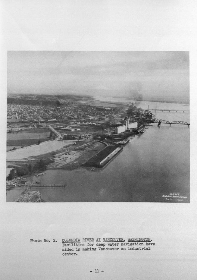
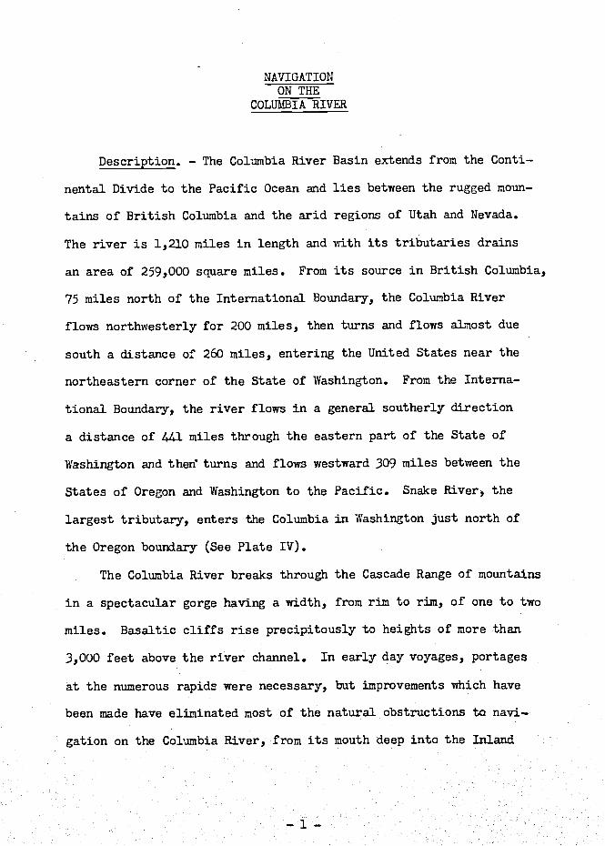
ioto No. 2. COLtJMEIA RIVER AT VANCOUVER, 7iASHINGTON.Facilities for deep water navigation haveaided in !naking Vancouver an industrial
center.
11-
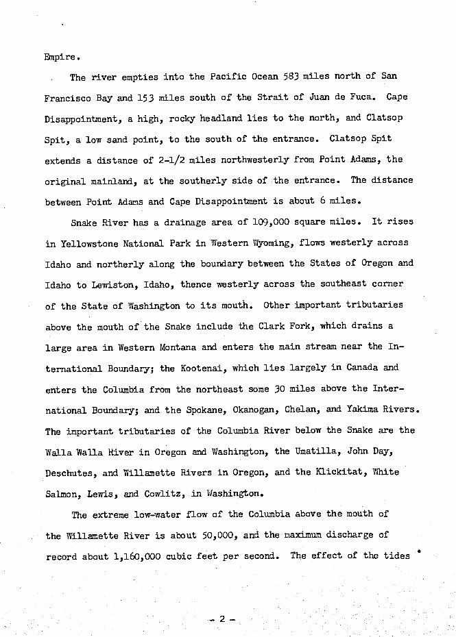
12
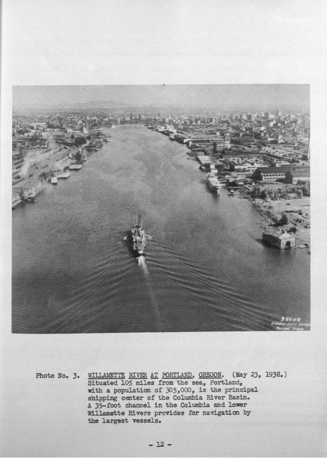
Photo No. 3. VILLAhTTE RIVER AT PORTLAND, OREGON. (May 23, 1938.)Situated 105 miles from the sea, Portland,with a population of 305,000, is the principalshipping center of the Columbia River Basin.A 35foot channel in the Columbia and lowerWillamette Rivers provides for navigation bythe largest vessels.
Navigation above Vancouver. - The principal obstacle to early
navigation on Columbia River between Vancouver and The Dalles was at
Cascade Rapids, 45 miles above Vancouver. In early-day voyages, por-
tages around Cascade Rapids were made with wagons. A tramway was con-
structed in 1859, aixl in 1862 a steam railway was built along the
Vashington shore from the foot to the head of the Cascades. Later, a
steam portage railway was built on the Oregon side.
The first steamer to navigate the river between the head of Cas-
cade Rapids and The Dalles was the James P. Flint, a small propeller-
driven vessel which was hauled on lines over the rapids in 1851. Four
vessels plied this reach of the river until-completion of the railroad
from Portland, Oregon, to liallula, ashington, in 1882, when this boat
service was discontinued. The Cascades Canal, by-passing the rapids,
was begun in 1378 and opened for navigation in 1896, but navigation
below the locks for a distance of several miles was still difficult
on account of the strong currents. Cascade Rapids are now drowned
out in the pooi above Bonneville Dam.
The Oregon Steam Navigation Company was incorporated at Vancouver,
ashington, December 29, 1860. This company carried on a very success-
ful operation on Columbia River until 1879, when it was taken over by
the Oregon Railway and Navigation Company. Beginning with two or three
small sternwheelers built for short trips out of Portland, the pioneer
company developed an extensive system covering nearly every important
route in the northwest and finally tapped the Inland Empire with nearly
2,000 miles of railroad.
Freight and passengers were transferred between The Dalles and
Celilo (ii miles) over a wagon road until 1862 when a portage rail-
road was constructed. In the same year, gold was discovered on the
Salmon River in Idaho, and during the next four years 10 or 12 boats
were in operation on the river above Celilo. These boats ran regular-
ly as far as Lewiston, Idaho, and made occasional trips on the Clear-
water and on the Snake above Lewiston. Activity declined from 1866
to 1870 and most of the boats were taken to lower river points. In
1882, upon completion of the railroad between Portland arI Wallula
(the present Union Pacific Railroad), regular boat service above Ce-
lilo Falls was discontinued. A few boats continued to operate on the
Snake River above the railroad crossing at Riparia. Navigation in
the reach between The Dalles and Celilo was riade possible by the pre-
sent canal, completed in 1915, although until recent years not much
use was made of the waterway provided. Navigation of the reach be-
tween the Cascades Canal and The Dalles continued until June 1923,
when regular boat service was discontinued on account of lack of busi-
ness. Since the comDletion of Bonneville Darn and ship lock, there
has been a revival of river commerce between Vancouver and The Dalles
and to the mouth of the Snake River.
One of the high-lights in the memory of many residents of the
Pacific Northwest is the boat trip up Columbia River to The Dalles.
For some 25 years prior to 1920, a number of steamers made this round
trip daily, carrying passengers and freight. Some of the best knoi,n
boats of this era were the Regulator, Dalles City, Charles R. Spencer,
and Bailey Gatzert. These steamers were excellently appointed,
sturdily constructed and designed for speed. Leaving Portland at the
same time, boats of rival companies often raced to Cascade Locks, as
the first to obtain passage through the locks was the first to reach
The Dalles. During one June freshet, when the locks could not be
operated, the Bailey Gatzert was brought down safely over Cascade
Rapids with upwards of 100 passengers on board. In earlier times,
a few boats had run these rapids and a lesser number had successfully
negotiated Cello Falls and the intervening swift water and tortuous
channel from there to The Dalles. The daring exploits of early-day
steamboat captains form an interesting chapter in the river's history.
Improvement of the reach between Vancouver, Washington, and
Bonneville, Oregon, authorized by the River and Harbor Act of August
26, 1937, will provide upon completion (probably early in l9L2) a
navigable channel 27 feet deep and 300 feet wide. A ship lock at
Bonneville provides for navigation past the Bonneville Dam, and the
pool created by the dam has a navigable depth of 30 feet extending
for L7 miles through the gorge to the foot of Five Mile Rapids at the
entrance to the Dalles-Celilo canal, 3 miles above The Dalles. These
improvements will enable ocean-going vessels of moderate draft to as-
cend the river for 190 miles. Navigation by river craft around the
falls and rapids extending 12 miles above The Dalles is afforded by
The Dalles-Celilo canal, a lateral waterway 8.6 miles long, 8 feet
deep, and 65 feet wide, with locks 265 feet long, L5 feet wide and
7 feet deep over the sills. The total lift is 56 feet at low water
ax 62 feet at high water. From Celilo to the mouth of the Snake
(123 miles), the Columbia River lies in a narrow valley, which is in
places 1,000 feet below the surrounding plateau. The low-water fall
totals 185 feet, about half of which occurs through 21 rapids having
a combined length of 20 miles and low-water gradients of 2 to 10 feet
per mile. The authorized project for improvement provides for the
excavation of a channel 7 feet deep and 150 feet wide through these
rapids to Wallula, and a channel of no prescribed dimensions in the
10-mile reach thence to the mouth of the Snake. Navigation is hin-
dered at present in the reach between Wallula aixl the mouth of the
Snake by the Homly Rapids. Work now in progress at that point will
provide a controlling depth of 5 feet for a width bf 100 feet. How-
ever, the channel is tortuous and velocities range up to 8 miles per
hour.
The Snake River is a swift-flowing stream in a generally deep
and narrow valley. The fall at low water in the 139-mile reach below
Lewiston, Idaho, totals 393 feet, three-fourths of which occurs through
56 rap'ids having a combined length of 45 miles and slopes ranging from
3 to 12 feet per mile. The authorized project for improvnent of this
stream provides for removal of rock reefs, dredging gravel bars and
the construction of contraction works with a view to securing a chan-
nel depth of 5 feet at low water from the mouth to Lewiston and for
the removal of obstructive rocks and reefs between Lewiston and
Johnson's Bar, a total distance of 232 miles.
A comprehensive plan for ultimate development of Columbia and
Snake Rivers in the interest of navigation, irrigation and the devel-.
opment of hydroelectric power is contained in House Document No. 704,
75th Congress, 3rd Session. Construction of a series of locks and
dams, under the pian presented, would provide for slack-water navi-
gation from the head of the Bonneville pool to Grand Coulee Dam on
the Columbia and a combination of open river and slack-water naviga-
tion on the Snake River to Asotin, Washington. Designs and estimates
are based on provision of adequate fishways, and of navigation locks
56 feet wide, 360 feet long, and 9 feet deep. Backwater from the
Grand Coulee Dam will extend nearly to the International Boundary,
but no navigation facilities are provided at the dam.
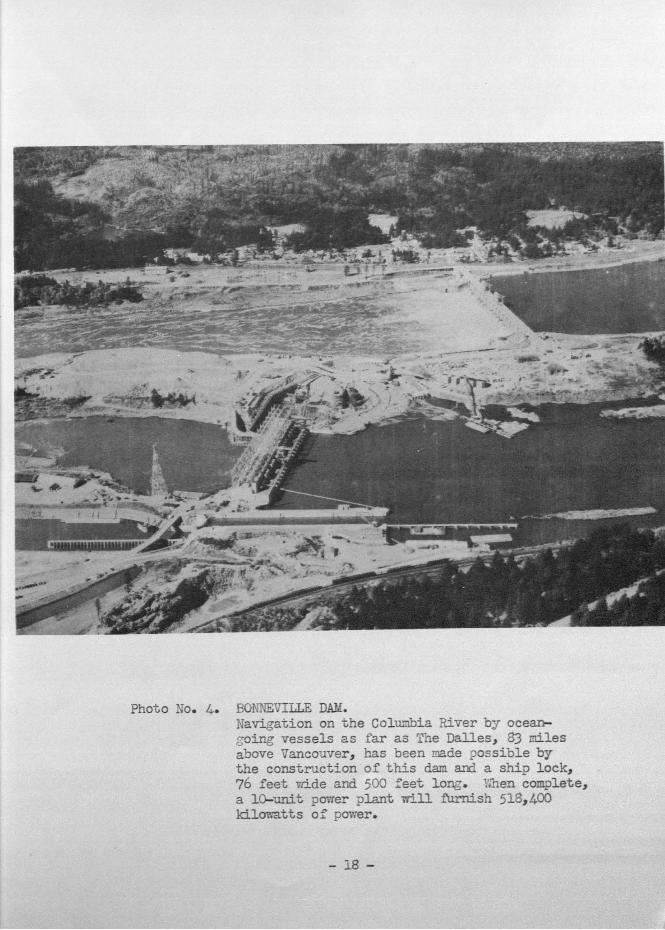
Photo No. 4. BONNEVILLE DAM.Navigation on the Colunbia River by ocean-oing vessels as far as The Dafles, 3 miles
above Vancouver, has been made ?ossiole bythe construction of this darn and a ship lock,
76 feet Lde and 500 feet long. Vthen complete,
a 10-unit power plant i±ll furnish 518,400lcLlowatts of power.
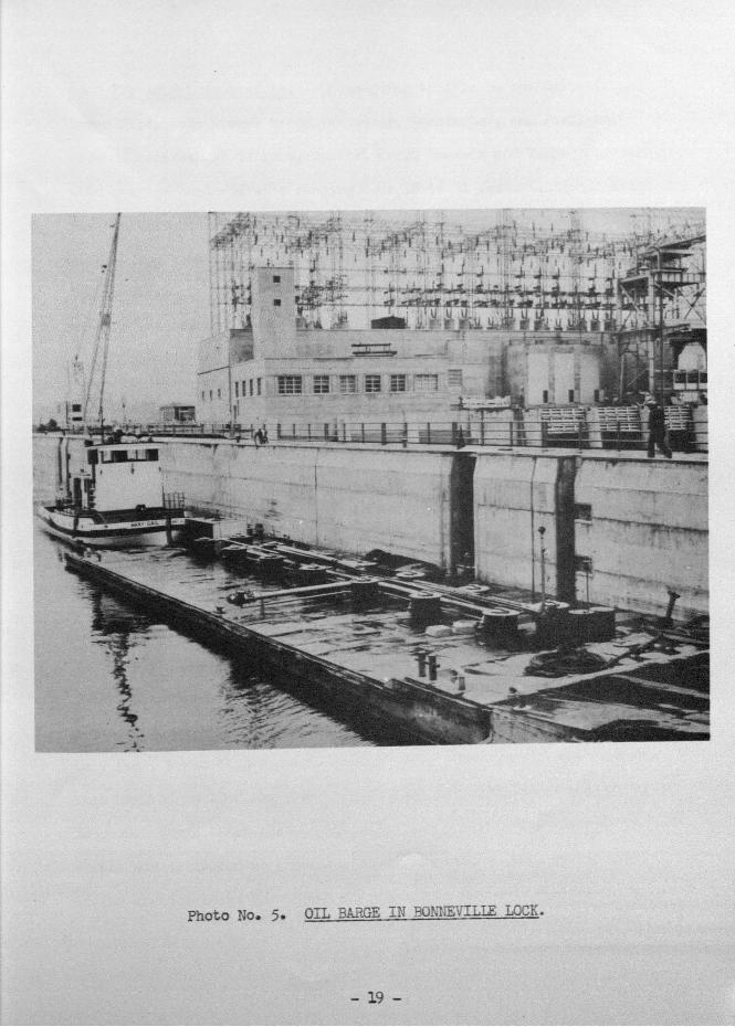
Photo No. 5. OIL BARGE IN BONNEVILLE LOCK.
- 19 -
Present river traffic. - Ocean-going traffic on the Columbia and
Lower Willaniette Rivers below Vancouver, Washington, and Portland,
Oregon, consists of tankers, general cargo vessels and lumber carriers,
with average loaded drafts ranging from 18 to 31 feet. Internal traf-
fic consists of river cargo boats, tug boats, barges and rafted logs.
Water-borne commerce on the Columbia and Lower Willamette Rivers during
the calendar year 1940 was valued at nearly $335,000,000. The total
tonnage handled amounted to a little more than 15,000,000, of which
62-1/2 percent consisted of vessel cargoes and the remainder rafted
logs.
The traffic between Vancouver, Washington, and The Dalles, Oregon,.
consists principally of fuel oil and gasoline upstream, and wheat down-
stream, with drafts of loaded vessels ranging from 6 to 11 feet. Some
logs aid piling are towed to Portland and other cities from points above
and below Bonneville. Commerce during 1940 was valued at $26,500,000
and amounted to about 3,500,000 tons, one-half of which was rafted logs
and piling.
Traffic passing throui The Dalles-Celilo Canal (controlling depth
7 feet at low water) and moving on the river between Cello and the
mouth of Snake River is carried by vessels having loaded drafts of 5
to 7 feet, towed barges being largely used. The value of the coinniodi-
ties handled in 1940 amounted to more than $9,000,000 with tonnage of
323,000. The greater part of the petr9leunl ?roducts transported up-
stream was delivered at Attalia, Washington, and a large percentage
of the wheat shipped downstream originated in the same vicinity. In
recent years, there has been considerable activity in interior trade,
the traffic increasing 150 percent in 1940 over that of 1939, and
recently showing further marked increases.
River Terminals. - At Astoria, Oregon, there is a. large municipal
terminal with grain elevator and flour mill. There are also a number
of private wharves for the shipment of canned salmon, lumber and flour,
and for the receipt of coal, oil, and general merchandise.
Two of the largest sawmills in the Pacific Northwest are located
at Longview, Washington, 65 miles above the mouth. A public terminal
is maintained by the Port of Longview and both of the mill companies
have wharves for the shipment of lumber.
At Kalarna, Washington, 73 miles above the mouth, there is a
rnunicipaJ. wharf for the shipment of lumber.
The Port of Vancouver, Washington, has two municipal terminal
wharves and there is a privately-owned grain elevator. In addition
to the public terminal facilities listed, there are numerous privately-
owned wharves on the Columbia River between Astoria and Vancouver, for
the acconmiodation of river boats and for the shipment of lumber in
ocean-going carriers.
In Portland, there are three river terminals for general cargo
which are under public ownership. In addition, there are two public
drydocks with capacities of 10,000 and 15,0)0 tons each. Under pri-
vate ownership, but open to the public on equal terms, are 11 general
cargo, 5 grain and flour, 6 lumber, 1 cement, and 9 crude oil and
gasoline terminals besides numerous outfitting and storage wharves.
There are, at prsent, no terminals suitable for ocean vessels
on the Columbia River between Vancouver, Washington, and Bonneville,
Oregon, though there are a number of wharves for the accommodation
of barges and river boats.
The Port of The Dalles (44 miles above Bonneville) has a munici-
pal wharf for use of both ocean-going and river boats. In addition,
there is a municipal oil terminal situated about a mile below the
main wharf Near the oil terminal are a number of privately-owned
storage tanks Bulk grain is handled in a privately-owned elevator.
In the reach of the river from The Dalles to the mouth of the
Snake, there are no public wharves, bat a number of facilities have
been provided for transferring bulk grain from trucks to river craft
and for transferring oil from river barges tc storage tanks on shore.
There are privatly-owned grain elevators at Umatilla and Blalock on
the Oregon side of the Columbia River and at Port Kelley and Attalia,
in Washington. At Umatifla, Oregon, and also at Attalia, Washington,
there are private storage tanks with capacities of about 5,000,000
gallons for handling petroleum products from river boats and barges.
Terminals are also under construction or proposed for early construc-
tion at Arlington, Oregon, and at Kennewick and Pasco, Washington.
The effect of navigation improvements upon industrial development.-
The growth of cities in the Columbia River Basin is associated closely
with the improvement of the rivers for navigation. The largest ships
have, for some time, been able to ply between the mouth of the Columbia
River and Portland, and the 27-foot project between Vancouver and The
Dafles is nearing completion. These river improvements and the power
supply available in the Pacific Northwest provide for almost unlimited
possibilities in industrial expansion. Water transportation is vital
to logging and lumbering, long the sustaining industries of thc. region.
Recently, the manufacture of aluminum has become an important industry
in the Columbia River Basin, made possible by the power available from
Bonneville Darn and facilities for navigation by ocean-going vessels.
The building o± new ships and the conversion of vessels for use in the
program of National Defense have also become activities of considerable
importance.
Resume. - The discovery of Columbia River by Captain Robert Gray,
the eventful journey of Lewis and Clark, and the voice of early settlers,
were deciding factors in fixing the territorial claim of the United
States to the Oregor Country and led to the eventual establishment of
the 49th parallel of latitude as the north boundary.
Since the time when pioneers began to arrive in the Northwest
over the "Oregon Trail", agricultural and commercial development has
been intimately associated with the navigation of the waterways of
the region. In this, the Columbia River and its tributaries have had
an important role. The discovery of gold in California, in Idaho,
and in Alaska; the inception of the great lumber industry; the first
shipnent of grain and many other momentous events have all had their
influence on the progress of navigation on the Columbia River.
Today, navigation on the improved waterways of the Columbia Rivei
Basin continues to be one of the principal factors in the economic
welfare of the Pacific Northwest. Comprehensive plans for future river
improvements are designed to keep pace with as well as to stimulate
the commercial and industrial development of the region.
- 23 -
MILEAGE TABLES
Columbia River
MilesFrom Mouth Point
14 Astoria, Ore.66 Longview, Yash.75 Kalania, Vash.
101.5 Mouth of Willarnette River106 Vancouver, Wash.145 Bonneville Darn149 Cascade Locks, Ore.189.5 The Dalles, Ore.201 Celilo, Ore.233 Blalock, Ore.242 Arlington, Ore.289 Urnatilla, Ore.312 Port Kelley, Wash.314 Waflula, Wash.318 Attalia, Wash.324 Mouth of Snake Iüver328 Pasco and Kennewick, 'Wash.400 Priest Rapids599 Grand Coulee Dani, Wash.749 International Boundary
Snake River
68 Riparia, Wash.84 Central Ferry Bridge, Wash.
139.5 Lewiston, Idaho148 Asotin, Wash.176 Oregon-Washington boundary line232 Johnson Bar Landing

4 45(5sf
$ $ '8
is
A ChARThewing part of (lie
COAST OF N.WAMERICA,with the tracks of His IWAJESTYs' Sloop
i)1SCOVERYai,,Lirme// 7'rn/i'r (7L47711J1,'Commanded by GE ORGE VANC OLIVER E(q and prepared
under hz.r i,nrned,ale ,n.bethon ty LieutJoeph Baker, in isAzeh
(ii#/,,usn/a/ r /,., /<-,w /,?"fel/ ,'.',',/ i//eriI,1IIrf//,?/i1
Lat:.3'X and Long'. ?Jô,?E. to Lat: ;i'.a.V. and Long'. d. 4oE.
at ,h.. d,ffin'nt pe'no.'IJ M' il14 91U4'kS
The parts not. aIaae&. air takrn from Spamulli Authoritie'.
ii. ,wfrj' tA Ith'/j t,urk .V'rt.4s,'ml ' i,.4ar ?thIro jrn,t/iHln1'.
- 1-
Scale oftwm, Leagues
(Lat: 46i9 TN.A0 LongTo) 06 E.
Var. o . 00 E
- .kENTRAHCE
of
COLUMBIA RIvET!
Note: The engraved chart bears no
date, but was published in 1i98.
tr'."rj,7T
,.,_,.. K
iN
:-.-
- *ti.. '' ''- 4':':-
5'-
PLATE
a - t- -
4
I
4t'
low
ldm
h.n
o1
'ai..
Eab
..pr
;y
Th
#i.-
.-'
_diA
.w .
fiMJ
£A
I,.. l
iii?ill ft.
x__I
.1,.
I.
S..-
.,
lr,r
.di.J
.w'
.h .n
I...J
Sliy
t
.%..J
I1. J
r..k
14,,t
.I, I
i...*
h.li.
.m.
hol.,
.n V
.II.
...
ln,li
..,,
1I..r
.h.
.r.-
n,.S
.S.i-
d.. i
;..-
Pd.M
. Il,.
4i.r
n V
5II.
.
lnli.
rn-
IIi,h
k...
*..
M'
'It'
..!! b
l.....
l a...
! th
i;...,
.,.t?
'n.
11..!
!..,l.
5 ,.W
M .i
l...
.I..h
,,l.d
..o.
Th.
Rii
i,l,,
dl.m
,.'-.
..3,
, -.T
ha, .
..l,
ah-
/i.,*
..T
hW
.eI'.
.!M
in .4
.n.
..__
,,.,I
..-j
ii.E
,7..,
.Ji,.
..l...
- ..,
ll.r
E1.
r lo
w!. -
Thè
iV*
l.F Il,f
l'1
Mr
..U
",'
i?i,.
,
1fr
Th. L*r
,,l.W
..I.k
l..,.
.J.
.,
,N
' .l
j.,
..I.
inal
S
ve__
'1j..
.d \.. .5.
low
....
lnp.
. HuN
.
l..i..
t
l.,4i
,, V
ul..,
.0.
thi.
I
IjS5.
...
o3 B
YIU
IH
JhT
EhV
,.hi.
!(.,
I.. S
Im4n
i..
14.#
i.*
rri4
1r.L
Lt
HK
DI'(
,PL
) Y
RO
)1I
5.
'5
N' U
o...I
tth,J
t Vi..
.Ion
di.;.
Mii.
...
WAR DEPARTMENT (1BPS OF ENGINEERS, US.ARMY
'I /r,-1A HL,rwa &\) t:i'eHoo,
8 2'/ - 0? V / 20 " , 2
US.E4GIWEER OFHCE, POPTLM4D.OPEGO&D4STRICTPscomrn -QvAo
Subm ttsd
Mesn Velocif end Dure+ion of' prevrlinwinds e+ Nor+h Heed fbr yeers 1929 to 938inclusive.Dur-tion in dss fbr averege yesr shownb length of' lines.'Jelocy in miles per hour shown b widthof' lines.
5 fo 0 miles10 -
30 or moreAvers of' I CIm 0IJ AnrruII
Scele o Daqs0 0 5 20 50 50
CAPEflOiNflAENr C:
C.MAI*.'7JQ4 P.2057 P
NOTESoundings er-s in f'ee+ end show the depth
f Megn Lowe, Low Wp+er.Neoigetion Aide shown 00 loceted f defeof' sur-oe1.30 '+. contour Shown, thus40-
PLATE LII
WAR DEPARThNT
LUTE U
zNorNEER, U.S. ARMY
Oistrct Bondcrystat. eoundory
State Capita!
ca.udrna RIvER ft
90F SNAxz RivEft
Ieli
ill- w
E
/
NORTH PACiFICDIVISION