Ordinance No. G-6107, PCC Sec. 36-158, Schedule 1 in W… · Web viewordinance g-6107. an...
32
ORDINANCE G-6107 AN ORDINANCE AMENDING CHAPTER 36 (VEHICLES AND TRAFFIC), ARTICLE XII, SECTION 36-158, SCHEDULE I OF THE PHOENIX CITY CODE RELATING TO LOCAL SPEED LIMITS. _______________ BE IT ORDAINED BY THE COUNCIL OF THE CITY OF PHOENIX as follows: SECTION 1. Chapter 36 (Vehicles and Traffic), Article XII, Section 36-158, Schedule I of the Phoenix City Code relating to local speed limits is amended to read as follows: Sec. 36-158. Schedule I - Local speed limits. It is hereby determined upon the basis of an engineering and traffic investigation that the speed limit permitted by state law on the following streets or intersections is greater or less than, is reasonable under existing conditions, and it is hereby declared that the maximum speed limits shall be as hereinafter set forth on those streets, parts of streets or intersections herein designated at the times specified when signs are erected giving notice thereof.
-
Upload
nguyennguyet -
Category
Documents
-
view
215 -
download
0
Transcript of Ordinance No. G-6107, PCC Sec. 36-158, Schedule 1 in W… · Web viewordinance g-6107. an...

ORDINANCE G-6107
AN ORDINANCE AMENDING CHAPTER 36 (VEHICLES AND TRAFFIC), ARTICLE XII, SECTION 36-158, SCHEDULE I OF THE PHOENIX CITY CODE RELATING TO LOCAL SPEED LIMITS.
_______________
BE IT ORDAINED BY THE COUNCIL OF THE CITY OF PHOENIX as
follows:
SECTION 1. Chapter 36 (Vehicles and Traffic), Article XII,
Section 36-158, Schedule I of the Phoenix City Code relating to local speed limits is
amended to read as follows:
Sec. 36-158. Schedule I - Local speed limits.
It is hereby determined upon the basis of an engineering and traffic investigation that the speed limit permitted by state law on the following streets or intersections is greater or less than, is reasonable under existing conditions, and it is hereby declared that the maximum speed limits shall be as hereinafter set forth on those streets, parts of streets or intersections herein designated at the times specified when signs are erected giving notice thereof.
THE CITY TRAFFIC ENGINEER MAY DECLARE A MAXIMUM SPEED LIMIT THAT IS DETERMINED PURSUANT TO THIS SECTION TO BE EFFECTIVE AT ALL TIMES OR AT SUCH TIMES AS INDICATED ON THE SPEED LIMIT SIGNS. THE CITY TRAFFIC ENGINEER MAY ESTABLISH LOWER SPEED LIMITS FOR DIFFERENT TIMES OF DAY, DIFFERENT TYPES OF VEHICLES, VARYING WEATHER CONDITIONS, SPECIAL EVENTS, WORK ZONES FOR CONSTRUCTION, MAINTENANCE OR OTHER ACTIVITY IN THE ROADWAY AND OTHER FACTORS BEARING ON SAFE SPEEDS. THE LOWER LIMITS ARE EFFECTIVE WHEN POSTED ON APPROPRIATE FIXED, VARIABLE OR PORTABLE SIGNS.

A. Prima Facie Speed Limit 30 Miles Per Hour at All Times.
Acoma Drive 51st Avenue to 43rd AvenueAcoma Drive Black Canyon Freeway to 23rd AvenueAcoma Drive 36th Street to 40th StreetAcoma Drive Tatum Boulevard to 64th StreetAir Lane 1,240 Feet East of 32nd Street to 750 Feet
East of 36th StreetArroyo Norte Drive Northbound I-17 Frontage Road to 3900 WestBeardsley Road 20th Street to Cave Creek RoadBriles Road/43rd Way 40th Street to Ramuda DriveBlack Mountain Boulevard Mayo Boulevard to Rough Rider RoadButler Drive 39th Avenue to 27th AvenueButler Drive Black Canyon Freeway to 19th AvenueCampbell Avenue 71st Avenue to 51st AvenueCampbell Avenue 113th Avenue to 107th AvenueCampbell Avenue 35th Avenue to 15th AvenueCampbell Avenue 12th Street to 16th StreetCampbell Avenue 20th Street to 44th StreetCanterbury Drive Thunderbird Road to Tam-O-Shanter DriveCashman Drive Pinnacle Peak Road to 44th StreetCentral Avenue Lincoln Street to Roosevelt StreetCentral Avenue Grovers Avenue to Union Hills DriveChauncey Lane 68th Street to Scottsdale RoadCholla Street 24th Street to 56th StreetClarendon Avenue 55th Avenue to Maryvale ParkwayColter Street 16th Street to SR-51Copperhead Trail North Valley Parkway to Gambit TrailCopperhead Trail West of 14TH Lane Traffic Circle to Gambit TrailCoral Gables Drive Thunderbird Road to 7th StreetDeer Valley Drive 0.5 Miles East of 7th Street to Cave Creek
RoadDesert Willow Parkway East Dixileta Drive to Dynamite BoulevardDesert Willow Parkway West 30200 North Cave Creek Road to 31000 North
Cave Creek Road Dobbins Road 16th Street to 20th Street
Dove Valley Road Paloma Parkway to 17th LaneDove Valley Road 52nd Place to 56th StreetDunlap Avenue 7th Street to 12th StreetDurango Street 67th Avenue to 63rd AvenueElwood Street 40th Street to 48th StreetEncanto Boulevard 93rd Avenue to 91st Avenue
Ordinance G-61072

Encanto Boulevard 75th Avenue to 73rd AvenueEncanto Boulevard 71st Avenue to 51st AvenueEncanto Boulevard 49th Avenue to 31st AvenueEncanto Boulevard Grand Avenue to 19th AvenueFreemont Road Rough Rider Road to Cashman DriveGalvin Parkway 100 Feet +/- North of East Papago Park to
Traffic Circle at Botanical Garden entranceGreenway Road 20th Street to Cave Creek RoadGrovers Avenue 51st Avenue to 27th AvenueGrovers Avenue Central Avenue to Cave Creek RoadHatcher Road Central Avenue to 16th StreetHATCHER ROAD CENTRAL AVENUE TO 12TH STREETHighland Avenue Campbell Avenue to 107th AvenueHighland Avenue 16th Street to 24th StreetIllini Street 30th Street to Riverpoint ParkwayJefferson Street 27th Avenue to 23rd AvenueJefferson Street 7th Avenue to 4th AvenueJefferson Street 4th Street to 7th StreetJesse Owens Parkway Central Avenue to 7th StreetJones Avenue 103RD Avenue to 99TH AvenueKelton Lane 29th Avenue to 28th AvenueKnox Road Warpaint Drive to 36th StreetLakewood Parkway West 3300 East to 3600 East to 17000 South to
15800 SouthLakewood Parkway East 3600 East to 3800 East to 17000 South to
15800 SouthLindner Drive (West Section) 45th Avenue to Augusta NorthLindner Drive (East Section) 45th Avenue to Grovers AvenueLockwood Drive Freemont Road to Cashman DriveMarriott Drive Pathfinder Drive to Deer Valley DriveMaryland Avenue 43rd Avenue to Black Canyon FreewayMaryvale Parkway 51st Avenue to Indian School RoadMayo Boulevard Black Mountain Boulevard to 40TH StreetMissouri Avenue 43rd Avenue to 27th AvenueMissouri Avenue Black Canyon Freeway to 19th AvenueMohave Street Central Avenue to 7th StreetMOHAVE STREET 7TH AVENUE TO 7TH STREETMorningside Drive Black Canyon Freeway to 21st AvenueMorton Avenue 16th Street to 1900 EastMountain View Road 23rd Avenue to 15th AvenueMountain View Road 12th Street to 17th StreetMountain View Road 32nd Street to 36th StreetNorthern Avenue 26th Street to 32nd StreetNorth Valley Parkway Carefree Highway to 33rd Lane
Ordinance G-61073

Oak Street 16th Street to 24th StreetOak Street 32nd Street to 44th StreetOak Street 48th Street to 52nd StreetOak Street (Eastbound) 56th Street to 64th StreetOlympic Drive Central Avenue to Jesse Owens ParkwayOrangewood Avenue 43rd Avenue to 19th AvenueOsborn Road 83rd Avenue to 75th AvenueOsborn Road 73rd Avenue to Grand AvenueOsborn Road Black Canyon Freeway to 19th AvenueOsborn Road 40th Street to 56th StreetParadise Lane 7th Street to 16th StreetParadise Lane Tatum Boulevard to 56th StreetParadise Lane 47th Avenue to 43rd AvenuePathfinder Drive 44th Street to Marriott DrivePiedmont Road 48th Street to 51st StreetPinnacle Vista Drive Pyramid Peak Parkway to Inspiration Mountain
ParkwayPinnacle Vista Drive 52nd Street to 56th StreetQuail Track Drive North Valley Parkway to Copperhead TrailRanger Drive Tatum Boulevard to 55th StreetRiverpoint Parkway Wood Street to Illini StreetRoeser Road 7th Avenue to Central AvenueRoeser Road 40th Street to 48th StreetRoosevelt Street 51st Avenue to 43rd AvenueRoosevelt Street 39th Avenue to 35th AvenueRoosevelt Street 33rd Avenue to 27th AvenueRoosevelt Street 19th Avenue to 16th StreetRose Garden Lane 29th Avenue to 19th AvenueRough Rider Road Aviano Way to 40th StreetSells Drive 79th Drive to 71st DriveSquaw Peak Drive Lincoln Drive to Squaw Peak Park BoundarySR-51 (East Access Road) 500 Feet North of Camelback Road to Colter
StreetStanford Drive 40th Street to 44th StreetStetson Hills Loop 43rd Avenue to 39th DriveSweetwater Avenue 51st Avenue to Black Canyon FreewaySweetwater Avenue 32nd Street to 42nd StreetSweetwater Avenue Paradise Valley Parkway East to Scottsdale
RoadThunderbird Road 28th Street to 32nd StreetTrailblazer Drive 44th Street to Tatum BoulevardUniversity Drive 24th Street to Magnolia Street (2700 East)Utopia Road 23rd Avenue to 19th AvenueVan Buren Street 7th Street to 16th Street
Ordinance G-61074

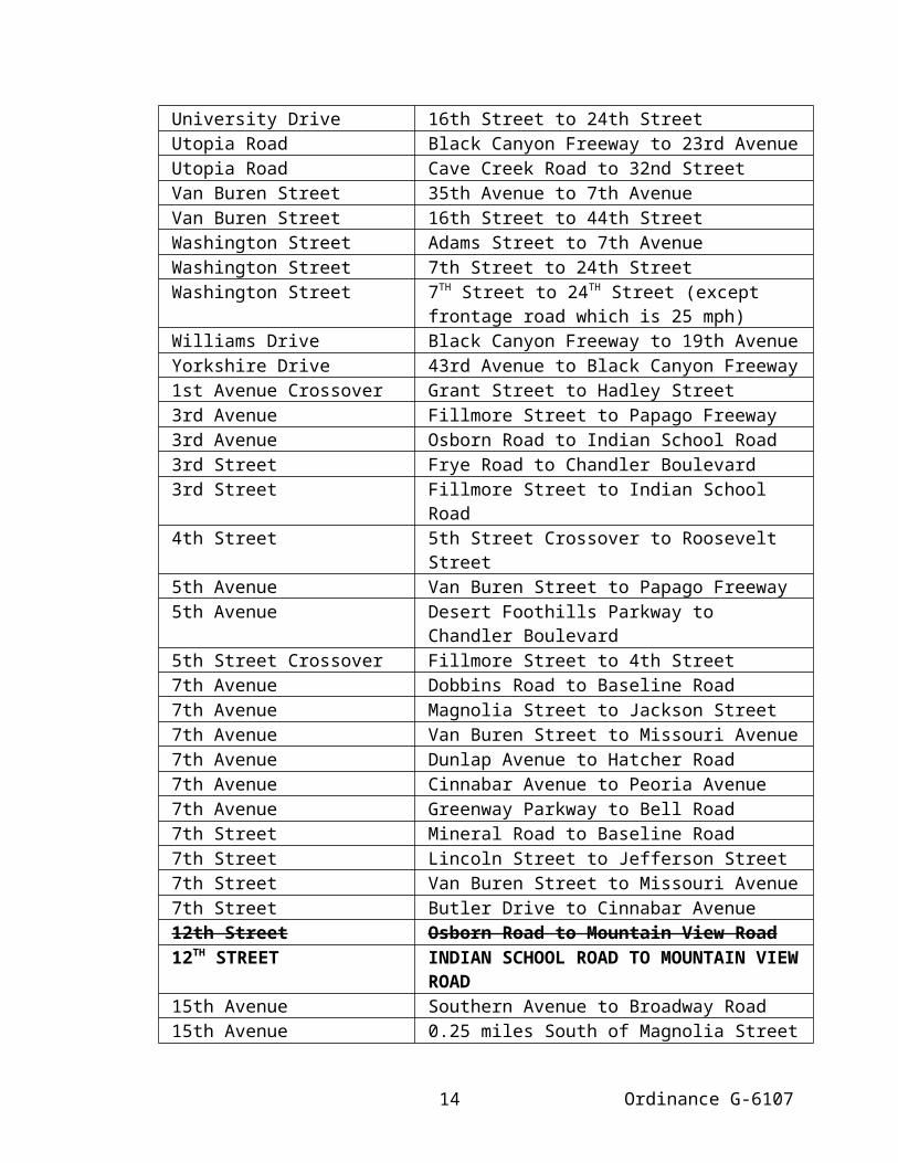
Via Del Deserto 33rd Lane to Via PuzzolaVia Puzzola Carefree Highway to Cloud RoadVia Tramonto Carefree Highway to Via VistaVia Vista 27th Avenue to Via TramontoVineyard Road 47TH Avenue to 43RD AvenueVirginia Avenue 35th Avenue to 27th AvenueVirginia Avenue Central Avenue to 12th StreetWarpaint Drive Knox Road to Coconino StreetWashington Street 7th Avenue to 4th AvenueWashington Street 4th Street to 7th StreetWier Avenue 39th Avenue to 35th AvenueWinchcomb Drive 26th Avenue to Acoma Drive (2300 West)Wood Street Riverpoint Parkway to University Drive1st Avenue Grant Street to Roosevelt Street3rd Avenue Van Buren Street to Fillmore Street3rd Avenue Papago Freeway to McDowell Road3rd Avenue Thomas Road to Osborn Road3rd Street Monroe Street to Fillmore Street5th Avenue Papago Freeway to McDowell Road5th Street Van Buren Street to 5th Street Crossover5th Street Crossover 5th Street to Fillmore Street7th Avenue Jackson Street to Van Buren Street7th Avenue Coral Gables Drive to Greenway Parkway7th Street Jefferson Street to Van Buren Street11th Avenue Greenway Parkway to Bell Road11th Street Washington Street to Moreland Street12th Street Vineyard Road to Southern Avenue12th Street Moreland Street to Thomas Road12TH STREET OSBORN ROAD TO INDIAN SCHOOL ROAD12th Street Bell Road to Agua Fria Freeway15th Avenue Harrison Street to Van Buren Street15th Avenue Bethany Home Road to Northern Avenue15th Avenue Hatcher Road to Shangri-La Road15th Avenue Bell Road to Grovers Avenue15th Avenue Union Hills Drive to Utopia Road16th Street Grovers Avenue to Beardsley Road18th Street Camelback Road to 500 Feet North of
Camelback Road20th Street Dobbins Road to Baseline Road20th Street Roeser Road to Broadway Road20th Street Jefferson Street to Roosevelt Street20th Street McDowell Road to Cambridge Avenue20TH Street Indian School Road to Highland Avenue20th Street Missouri Avenue to Bethany Home Road
Ordinance G-61075

21st Avenue Bell Road to Union Hills Drive23rd Avenue Indian School Road to Bethany Home Road23rd Avenue Orangewood Avenue to Dunlap Avenue23rd Avenue Acoma Drive to Greenway Road23rd Avenue Union Hills Drive to Utopia Road24th Street Shea Boulevard to Sweetwater Avenue26th Avenue Thunderbird Road to Acoma Drive26th Street SR-51 to Shea Boulevard27th Avenue Rose Garden Lane to Deer Valley Drive27th Drive Carefree Highway to Via Vista28th Street Cholla Street to Thunderbird Road28th Street Oak Street to Camelback Road28th Avenue 29th Avenue to Kelton Lane29th Avenue Union Hills Drive to Kristal Way29th Avenue Beardsley Road to Rose Garden Lane31st Avenue Van Buren Street to Encanto Boulevard31st Avenue Thomas Road to Grand Avenue31st Avenue Indian School Road to Camelback Road31st Avenue Missouri Avenue to Orangewood Avenue31st Avenue Northern Avenue to Dunlap Avenue31st Avenue Cheryl Drive To Thunderbird Road31st Avenue Bell Road to Kristal Way31st Avenue Yorkshire Drive to Beardsley Road32nd Street 750 feet South of Beautiful Lane to Baseline
Road32nd Street Puget Avenue to Mountain View Road33rd Lane North Valley Parkway to Via Del Deserto35th Avenue Happy Valley Road to 800 Feet North of
Hackamore Drive36th Street Ranch Circle North to Suncrest Court36th Street Roeser Road to Broadway Road36th Street McDowell Road to Camelback Road36th Street Mountain View Road to Shea Boulevard36th Street Cactus Road to Greenway Road39th Avenue Van Buren Street to Osborn Road39th Avenue Missouri Avenue to Camino Acequia39th Avenue Peoria Avenue to Cactus Road39th Avenue Bell Road to Yorkshire Drive40th Street University Drive to .25 miles North of University
Drive40th Street Mountain View Road to Shea Boulevard44th Street Frye Road to Chandler Boulevard44th Street Ray Road to Warner-Elliot Loop44th Street Paradise Village Parkway North to Bell Road
Ordinance G-61076

44th Street Deer Valley Drive to Cashman Drive45th Avenue Bell Road to Union Hills Drive46th Street Paradise Village Parkway North to Thunderbird
Road47TH Avenue Baseline Road to Vineyard Road47th Avenue Thomas Road to Camelback Road47TH Avenue Thunderbird Road to Greenway Road47th Avenue Acoma Drive to Bell Road48th Street Pecos Park Entrance to Frye Road48TH Street Elwood Street to University Drive48th Street Van Buren Street to McDowell Road48th Street Cholla Street to Paradise Village Parkway
South50th Street Frye Road to Chandler Boulevard51st Street Elliot Road to Piedmont Road52nd Place Rancho Paloma Drive to Dove Valley Road52nd Street Thomas Road to Osborn Road52nd Street Cholla Street to Cactus Road52nd Street Thunderbird Road to Bell Road52nd Street Jomax Road to Pinnacle Vista Drive53rd Avenue Maryvale Parkway to Indian School Road55th Avenue McDowell Road to Camelback Road55th Avenue Pinnacle Peak Road to Alameda Road56th Street Camelback Road to Rockridge Road56th Street Mountain View Road to Shea Boulevard60th Street Desert Cove Avenue to Cholla Street Alignment60th Street Cactus Road to Bell Road63rd Avenue Lower Buckeye Road to Pima Street63rd Avenue Thomas Road to Osborn Road63rd Avenue Indian School Road to Camelback Road70th Street Princess Drive to Mayo Boulevard71st Avenue Van Buren Street to Roosevelt Street71st Avenue McDowell Road to Indian School Road71st Avenue Campbell Avenue to Camelback Road71st Drive Indian School Road to Sells Drive79th Drive Osborn Road to Sells Drive80th Lane Thomas Road to Osborn Road93rd Avenue Encanto Boulevard to Thomas Road103RD Avenue Broadway Road to Country Place Boulevard103rd Avenue Indian School Road to Campbell Avenue111th Avenue Campbell Avenue to Camelback Road
Ordinance G-61077

A1. Prima Facie Speed Limit 30 Miles Per Hour from 7 A.M. to 4 P. M. on School Days.
Ray Road 400 Feet North of Thunderhill Drive to 100 Feet South of Mountain Sky Avenue
19th Avenue 450 Feet North of Orangewood Avenue to 450 Feet South of Orangewood Avenue
B. Prima Facie Speed Limit 35 Miles Per Hour at All Times.
Adams Street 27th Avenue to Washington StreetAir Lane 32nd Street to 1,240 Feet East of 32nd StreetAir Lane 750 Feet East of 36th Street to 40th StreetAnthem Way 43rd Avenue to Black Canyon FreewayBethany Home Road 16th Street to 18th StreetBlack Canyon FreewayFrontage Road
Madison Street to Van Buren Street
Black Canyon FreewayFrontage Road (Southbound)
Interstate 17 Milepost No. 213.34 (North of Bell Road) to Bell Road
Black Mountain Parkway Rancho Paloma Drive to Carefree HighwayBuckeye Road 31st Avenue to 27th StreetCamelback Road 27th Avenue to 28th StreetCarefree Highway 3900 West to 700 Feet East of 33rd AvenueCentral Avenue Briarwood Terrace to Chandler BoulevardCentral Avenue Mineral Road to Thunderbird TrailCentral Avenue(Southbound)
Thunderbird Trail to Dobbins Road
Central Avenue Vineyard Road to Pioneer StreetCentral Avenue Watkins Street to Lincoln StreetCentral Avenue Roosevelt Street to Orange DriveCentral Avenue Arizona Canal to Mountain View RoadCentral Avenue Happy Valley Road to 2,050 Feet +/- North of
Happy Valley RoadChandler Boulevard(Westbound)
19th Avenue to 15th Avenue
Chandler Boulevard Pecos Road to Shaughnessey RoadCheryl Drive 35th Avenue to Metro Parkway WestCircle Mountain Road New River Road to Barko LaneCotton Center Boulevard 40TH Street to 48TH StreetDeer Valley Drive 1200 Feet West of 35th Avenue to 35th AvenueDesert Foothills Parkway Chandler Boulevard to 5th AvenueDesert Willow Parkway East 31000 North Cave Creek Road (East Side) to
5000 East Dixileta DriveDobbins Road Central Avenue to 16th StreetDove Valley Road North Valley Parkway to 16TH Avenue
Ordinance G-61078

Dunlap Avenue 7th Avenue to 7th StreetEncanto Boulevard 83rd Avenue to 75th AvenueFrye Road 3rd Street to Desert Foothills ParkwayGalvin Parkway North of Traffic Circle at Botanical Garden entry
to McDowell RoadGrand Avenue 19th Avenue to 7th AvenueGrant Street Black Canyon Freeway to Lincoln StreetGrant Street 16th Street to Sky Harbor CircleGreenway Road Cave Creek Road to Greenway ParkwayGuadalupe Road 48th Street to Interstate 10Hatcher Road 19th Avenue to Central AvenueHess Street 24th Street to 26th StreetHolmes Boulevard Bell Road to Grovers AvenueIndian School Road 27th Avenue to 20th StreetIndian School Road 45th Street to 48th StreetJefferson Street 23rd Avenue to 7th AvenueJefferson Street 7th Street to Washington StreetJefferson Street 7th Street to 265 Feet +/- East of 26th Street
(except frontage road which is 25 mph)Jomax Road 40th Street to 52nd StreetKnox Road 36th Street to 48th StreetLafayette Boulevard 44th Street to 64th StreetLiberty Lane 17th Avenue to Central AvenueLiberty Lane Desert Foothills Parkway to 13th WayLincoln Street Grant Street to 7th StreetLone Mountain Road 40th Street to Cave Creek RoadLower Buckeye Road 300 Feet West to 300 Feet East of 99TH AvenueLower Buckeye Road 22nd Avenue to 19th AvenueMaryland Avenue 19th Avenue to 16th StreetMaryvale Parkway Indian School Road to 51st AvenueMcDowell Road 27th Avenue to 32nd StreetMetro Parkway Entire Street surrounding Metro CenterMissouri Avenue 19th Avenue to 24th StreetMohave Street 7th Street to Sky Harbor CircleMohave Street 22nd Street to 24th StreetMountain View Road Central Avenue to 12th StreetNorterra Parkway Happy Valley Road to Jomax RoadOak Street 24th Street to 32nd StreetOak Street 52nd Street to 56th StreetOld Tower Road 26th Street to 32nd StreetOsborn Road 19th Avenue to 36th StreetPaloma Parkway Bronco Butte Trail to Dove Valley RoadParadise Village Parkway Entire Street Surrounding Paradise VillagePecos Road (Westbound) 1800 Feet East of 27th Avenue to 27th Avenue
Ordinance G-61079

Peoria Avenue 19th Avenue to 7th AvenuePinnacle Peak Road 19th Avenue to 7TH StreetPointe Golf Club Drive Thunderbird Road to Friess DrivePrincess Drive 68th Street to Scottsdale RoadPyramid Peak Parkway (Northbound)
1900 feet +/- north of Brookhart Way to City Limits
Ranch Circle North Ray Road (3600 East) to Ray Road (4300 East)
Ranch Circle South Ray Road to Mountain ParkwayRancho Paloma Drive Black Mountain Boulevard to 56TH StreetRoeser Road Central Avenue to 40th StreetRoosevelt Street 59th Avenue to 51st AvenueRoosevelt Street 16th Street to 32nd StreetRose Garden Lane 19th Avenue to 7th AvenueShea Boulevard 24th Street to 32nd StreetSky Harbor Circle 22nd Street to Grant Street, Mohave Street to
Grant Street, and Mohave Street to 22nd StreetSouthern Avenue 7th Avenue to 7th StreetSweetwater Avenue Cave Creek Road to 32nd StreetTatum Boulevard 40th Street to Cave Creek RoadThistle Landing Drive 48th Street to 50th StreetThomas Road 27th Avenue to 32nd StreetThunderbird Road 32nd Street to 38th PlaceTombstone Trail Norterra Parkway to 21st AvenueUniversity Drive 16th Street to 24th StreetUtopia Road Black Canyon Freeway to 23rd AvenueUtopia Road Cave Creek Road to 32nd StreetVan Buren Street 35th Avenue to 7th AvenueVan Buren Street 16th Street to 44th StreetWashington Street Adams Street to 7th AvenueWashington Street 7th Street to 24th StreetWashington Street 7TH Street to 24TH Street (except frontage road
which is 25 mph)Williams Drive Black Canyon Freeway to 19th AvenueYorkshire Drive 43rd Avenue to Black Canyon Freeway1st Avenue Crossover Grant Street to Hadley Street3rd Avenue Fillmore Street to Papago Freeway3rd Avenue Osborn Road to Indian School Road3rd Street Frye Road to Chandler Boulevard3rd Street Fillmore Street to Indian School Road4th Street 5th Street Crossover to Roosevelt Street5th Avenue Van Buren Street to Papago Freeway5th Avenue Desert Foothills Parkway to Chandler
Boulevard
Ordinance G-610710

5th Street Crossover Fillmore Street to 4th Street7th Avenue Dobbins Road to Baseline Road7th Avenue Magnolia Street to Jackson Street7th Avenue Van Buren Street to Missouri Avenue7th Avenue Dunlap Avenue to Hatcher Road7th Avenue Cinnabar Avenue to Peoria Avenue7th Avenue Greenway Parkway to Bell Road7th Street Mineral Road to Baseline Road7th Street Lincoln Street to Jefferson Street7th Street Van Buren Street to Missouri Avenue7th Street Butler Drive to Cinnabar Avenue12th Street Osborn Road to Mountain View Road12TH STREET INDIAN SCHOOL ROAD TO MOUNTAIN
VIEW ROAD15th Avenue Southern Avenue to Broadway Road15th Avenue 0.25 miles South of Magnolia Street to Harrison
Street15th Avenue Van Buren Street to Bethany Home Road16th Street Dobbins Road to Baseline Road16th Street Maricopa Freeway to Bethany Home Road16th Street Bell Road to Grovers Avenue17th Avenue Pecos Road to Chandler Boulevard17th Avenue Buckeye Road to Grant Street19th Avenue Buckeye Road to the Grand Canal19th Avenue Glendale Avenue to Northern Avenue (Except
where noted in [subsection] A1)20TH Street Greenfield Road to Indian School Road20TH Street Highland Avenue to Missouri Avenue21st Avenue Jomax Road to Tombstone Trail23rd Avenue Bethany Home Road to Glendale Avenue23rd Avenue Mountain View Road to Cactus Road23rd Avenue Utopia Road to Deer Valley Drive23rd Avenue Pinnacle Peak Road to Happy Valley Road24th Street South Mountain Avenue to Baseline Road24th Street Buckeye Road to Indian School Road25th Avenue Dunlap Avenue to Peoria Avenue26th Street Old Tower Road to Hess Street27th Avenue South Mountain Avenue to Baseline Road27th Avenue Lower Buckeye Road to Van Buren Street27th Avenue Northern Avenue to Dunlap Avenue27th Avenue Grovers Avenue to Union Hills Drive27th Avenue Yorkshire Drive to Rose Garden Lane27th Drive North Valley Parkway to Carefree Highway28th Drive Peoria Avenue to Cactus Road
Ordinance G-610711

29th Avenue Dunlap Avenue to Metro Parkway29th Avenue Greenway Road to Bell Road32nd Street Air Lane to Van Buren Street32nd Street Chandler Boulevard to Pecos Road35th Avenue South Mountain Avenue to Baseline Road35th Avenue Van Buren Street to Encanto Boulevard36th Street Shea Boulevard to Cactus Road39th Drive Pinnacle Peak Road to Happy Valley Road40th Street 0.39 miles South of Air Lane to Washington
Street40th Street McDowell Road to Missouri Avenue40th Street Potter Drive to Deer Valley Drive40th Street Tatum Boulevard to Lone Mountain Road43rd Avenue Olney Avenue to Dobbins Road43rd Avenue Elwood Street Alignment to Lower Buckeye
Road43rd Avenue Anthem Way to 1930 Feet North of Anthem
Way44TH Place Cotton Center Boulevard to Broadway Road48th Street Frye Road to Chandler Boulevard48th Street Washington Street to Van Buren Street48th Street Piedmont Road to Guadalupe Road50th Street Chandler Boulevard to Ray Road51st Street 500 Feet South of Elliot Road to Warner-Elliot
Loop52nd Street McDowell Road to Thomas Road52nd Street Cactus Road to Thunderbird Road55th Avenue Alameda Road to Happy Valley Road56th Street South City Limit to Van Buren Street56th Street Oak Street to Camelback Road56th Street Bell Road to Central Arizona Project Canal56th Street Lone Mountain Road to Rancho Paloma Drive64th Street Oak Street to McDowell Road (Southbound
Only)64th Street 255 Feet North of Hillcrest Boulevard to
Chaparral Road68th Street Princess Drive to Mayo Boulevard71st Avenue Baseline Road to Vineyard Road107th Avenue Camelback Road to Missouri Avenue
B1. Prima Facie Speed Limit 35 Miles Per Hour from 7 A.M. to 4 P.M. on School Days.
Ordinance G-610712

Greenway Parkway 400 Feet West of 7th Avenue to 250 Feet East of 5th Avenue
DUNLAP AVENUE FOR WESTBOUND, 650 FEET +/- WEST OF 29TH AVENUE TO 625 +/- WEST OF 35TH AVENUE
DUNLAP AVENUE FOR EASTBOUND, 545 FEET +/- WEST OF 35TH AVENUE TO 30TH AVENUE
B2. PRIMA FACIE SPEED LIMIT 35 MILES PER HOUR FROM 7 A.M. TO 5 P.M. ON SCHOOL DAYS.
GREENWAY PARKWAY 400 FEET WEST OF 7TH AVENUE TO 250 FEET EAST OF 5TH AVENUE
C. Prima Facie Speed Limit 40 Miles Per Hour at All Times.
Air Lane 24th Street to 32nd StreetBaseline Road 51ST Avenue to 35th AvenueBaseline Road 7th Avenue to 7th StreetBeardsley Road(Eastbound Frontage)
37th Avenue to 27th Avenue
Beardsley Road Cave Creek Road to 32nd StreetBell Road 19th Avenue to 12th StreetBell Road 0.25 miles West of Cave Creek Road to 1500
Feet East of 40th StreetBethany Home Road 43rd Avenue to 16th StreetBlack Canyon FreewayFrontage Roads
Maricopa Freeway to Madison Street
Black Canyon FreewayFrontage Road (Northbound)
Thomas Road to Cactus Road
Black Canyon FreewayFrontage Road (Northbound)
Bell Road to Union Hills Drive
Black Canyon FreewayFrontage Road (Southbound)
Mountain View Road (Alignment) to Thomas Road
Broadway Road 19th Avenue to 32nd StreetBuckeye Road 39th Avenue to 31st AvenueCactus Road 39th Avenue to 19th AvenueCactus Road Cave Creek Road to 60th StreetCamelback Road 43rd Avenue to 27th AvenueCamelback Road 28th Street to 64th StreetCave Creek Road Dunlap Avenue to Peoria AvenueCave Creek Road Marco Polo Road to Rose Garden LaneCentral Avenue (Northbound) Thunderbird Trail to Dobbins Road
Ordinance G-610713
Central Avenue Dobbins Road to Vineyard RoadCentral Avenue Pioneer Street to Watkins StreetCentral Avenue Orange Drive to the Arizona CanalChandler Boulevard Marketplace Way to 34th StreetDeer Valley Drive 600 Feet West of 27th Avenue to 0.25 Miles
East of 19th AvenueDeer Valley Drive 600 Feet West of 16th Street to 56TH StreetDesert Foothills Parkway Pecos Road to Chandler BoulevardDesert Peak Parkway Lieber Place to Cave Creek RoadDobbins Road From West City Limit to 1,320 Feet +/- EastDobbins Road 23rd Avenue to Central AvenueDunlap Avenue 43rd Avenue to 7th AvenueDUNLAP AVENUE 43RD AVENUE TO 7TH AVENUE (EXCEPT
WHERE NOTED IN SUBSECTION B1. OF THIS SECTION)
Durango Street 35th Avenue to Black Canyon FreewayElliot Road 2,085 Feet +/- West of 59TH Avenue to 51ST
AvenueElliot Road 46th Street to 51st StreetElwood Street 7th Street to 16th StreetGalvin Parkway Van Buren Street to 100 Feet +/ - North of
East Papago Park (Zoo entrance)Gavilan Peak Parkway 800 Feet +/- West of 33rd Lane to Cloud RoadGlendale Avenue 43rd Avenue to 21st StreetGrand Avenue 21st Avenue to 19th AvenueGreenway Parkway 500 Feet West of 7th Avenue to 3rd Avenue
(Except where noted in [subsection] B1)GREENWAY PARKWAY 500 FEET WEST OF 7TH AVENUE TO 3RD
AVENUE (EXCEPT WHERE NOTED IN [SUBSECTION] B2)
Greenway Parkway Cave Creek Road to Greenway RoadGreenway Road 51st Avenue to 19th AvenueGreenway Road Greenway Parkway to 300 Feet East of 30th
StreetGreenway Road 52nd Street to 500 Feet East of 60th StreetHappy Valley Road 35th Avenue to Black Canyon FreewayIndian School Road 67th Avenue to 27th AvenueIndian School Road 20th Street to 45th StreetIndian School Road 48th Street to 60th StreetJomax Road Black Canyon Freeway to Norterra ParkwayLiberty Lane 13th Way to 24th StreetLincoln Drive 21st Street to 800 Feet East of Ocotillo RoadLower Buckeye Road 103rd Avenue to 300 Feet +/- West of 99TH
AvenueLower Buckeye Road 300 Feet +/- East of 99TH Avenue to 95TH
Ordinance G-610714

AvenueLower Buckeye Road 27th Avenue to 22nd AvenueMaricopa FreewayFrontage Roads
23rd Avenue to 16th Street
McDowell Road 43rd Avenue to 27th AvenueMcDowell Road 32nd Street to 52nd StreetMountain Parkway Chandler Boulevard to Ray RoadNorterra Parkway Jomax Road to North Valley ParkwayNorthern Avenue 43rd Avenue to SR-51North Valley Parkway Jomax Road to 27th DriveNorth Valley Parkway 800 Feet +/- West of 33RD Lane to 33RD LanePecos Road (Westbound) 17th Avenue to 27th AvenuePECOS ROAD (WESTBOUND)
CHANDLER BOULEVARD TO 17TH AVENUE
Peoria Avenue 43rd Avenue to 19th AvenuePyramid Peak Parkway (Southbound)
67th Avenue to City Limits
Pyramid Peak Parkway (Northbound)
67th Avenue to 1900 Feet +/- North of Brookhart Way
Ray Road Chandler Boulevard to Interstate 10 (Except where noted in [subsection] A1)
Rose Garden Lane Cave Creek Road to 32nd StreetShea Boulevard 32nd Street to 450 Feet East of 40th StreetSouthern Avenue 19th Avenue to 7th AvenueSouthern Avenue 7th Street to 24th StreetThomas Road 800 Feet West of 59th Avenue to Grand
AvenueThomas Road 32nd Street to 56th StreetThunderbird Road 31st Avenue to Coral Gables DriveThunderbird Road 38th Place to Scottsdale RoadUnion Hills Drive 27th Avenue to 19th AvenueUnion Hills Drive 7th Street to 20th StreetUniversity Drive Wood Street to 48th StreetVan Buren Street 67th Avenue to 200 Feet West of 63rd AvenueVan Buren Street 39th Avenue to 35th AvenueVan Buren Street 44th Street to 56th StreetWarner-Elliot Loop 4600 East Elliot Road to 578 Feet East of
Wakial LoopWashington Street 24th Street to 34th Street7th Avenue Baseline Road to Magnolia Street7th Avenue Missouri Avenue to Dunlap Avenue7th Avenue Bell Road to Union Hills Drive7th Avenue Rose Garden Lane to Deer Valley Drive7th Street Baseline Road to Lincoln Street
Ordinance G-610715

7th Street Missouri Avenue to Butler Drive7th Street Cinnabar Avenue to 400 Feet North of Peoria
Avenue7th Street Thunderbird Road to 600 Feet North of Bell
Road16th Street Baseline Road to the Maricopa Freeway16th Street Bethany Home Road to Northern Avenue19th Avenue Southern Avenue to Buckeye Road19th Avenue Grand Canal to Glendale Avenue19th Avenue Northern Avenue to Evans Drive24th Street Pecos Road to Chandler Boulevard24th Street Baseline Road to Buckeye Road24th Street Indian School Road to Montebello Avenue27th Avenue Baseline Road to 500 Feet +/- North27th Avenue Van Buren Street to Northern Avenue32nd Street Baseline Road to Wood Street32nd Street Van Buren Street to the Arizona Canal32nd Street Mountain View Road to Bell Road32nd Street Beardsley Road to Rose Garden lane35th Avenue Dobbins Road to South Mountain Avenue35th Avenue Baseline Road to Broadway Road35th Avenue Lower Buckeye Road to Van Buren Street35th Avenue Encanto Boulevard to Bell Road35th Avenue Union Hills Drive to Beardsley Road40th Street Pecos Road to Chandler Boulevard40th Street 800 Feet South of Roeser Road to University
Drive40th Street Washington Street to McDowell Road40th Street Shea Boulevard to Union Hills Drive40th Street Deer Valley Drive to Pinnacle Peak Road43rd Avenue Buckeye Road to Glendale Avenue43rd Avenue Thunderbird Road to Beardsley Road43rd Avenue Pinnacle Peak Road to Happy Valley Road44th Street Washington Street to McDonald Drive48th Street Chandler Boulevard to Piedmont Road51st Avenue Dobbins Road to Baseline Road51st Avenue 0.5 Miles South of Lower Buckeye Road to
Lower Buckeye Road51st Avenue Roosevelt Street to Camelback Road51st Avenue 250 Feet South of Cactus Road to Union Hills
Drive51st Avenue Pinnacle Peak Road to Happy Valley Road52nd Street Van Buren Street to McDowell Road56th Street Shea Boulevard to Bell Road
Ordinance G-610716

56th Street Central Arizona Project Canal to Deer Valley Drive
59th Avenue Roosevelt Street to Camelback Road64th Street Cactus Road to Bell Road67th Avenue 400 Feet +/- South of Elwood Street to
Camelback Road67th Avenue Happy Valley Road to Pyramid Peak Parkway75th Avenue 0.25 Miles South of Thomas Road to
Devonshire Avenue83rd Avenue Van Buren Street to Papago Freeway91st Avenue McDowell Road to Indian School Road99th Avenue 0.5 Miles South of Lower Buckeye Road to
Durango Street107th Avenue Indian School Road to Camelback Road
D. Prima Facie Speed Limit 45 Miles Per Hour at All Times.
BASELINE ROAD 55TH AVENUE TO 51ST AVENUEBaseline Road 27th Avenue to 7th AvenueBaseline Road 7th Street to 48th StreetBeardsley Road(Frontage Roads)
27th Avenue to 20th Street
Beardsley RoadFrontage Road (Westbound)
27th Avenue to 51st Avenue
Beardsley RoadFrontage Road (Eastbound)
51st Avenue to 37th Avenue
Bell Road 51st Avenue to 19th AvenueBell Road 12th Street to 0.25 Miles West of Cave Creek
RoadBell Road 1500 Feet East of 40th Street to Scottsdale
RoadBlack Canyon Frontage Road
Van Buren Street to Thomas Road
Black CanyonFrontage Road (Northbound)
Cactus Road to Greenway Road
Black CanyonFrontage Road (Southbound)
Union Hills Drive to MP 213.34 (North of Bell Road)
Black CanyonFrontage Road (Southbound)
Bell Road to Mountain View Road Frontage Road (Alignment)
Broadway Road 107th Avenue to 99th AvenueBroadway Road 27th Avenue to 19th AvenueBroadway Road 32nd Street to 48th StreetBuckeye Road 71st Avenue to 39th AvenueCactus Road 51st Avenue to 39th AvenueCamelback Road 113th Avenue to 99th Avenue
Ordinance G-610717

Carefree Highway 4700 West to 3900 WestCarefree Highway 700 Feet East of 33rd Avenue to 0.5 Miles East
of Via TramontoCave Creek Road Peoria Avenue to Marco Polo RoadCave Creek Road Rose Garden Lane to Pinnacle Peak RoadCave Creek Road Peak View Road to Westland RoadChandler Boulevard(Eastbound)
19th Avenue to 15th Avenue
Chandler Boulevard 15th Avenue to Marketplace WayChandler Boulevard 34th Street to Interstate 10Deer Valley Drive 35th Avenue to 600 Feet West of 27th AvenueDeer Valley Drive 0.25 Miles East of 19th Avenue to 600 Feet
West of 16th StreetDixileta Drive Tatum Boulevard to 52nd StreetDobbins Road 1,320 Feet +/- East of City Limit to 200 Feet +/-
West of 56th GlenDobbins Road 0.25 Miles West of 35th Avenue to 33rd
AvenueDobbins Road 27th Avenue to 23rd AvenueDove Valley Road 16th Avenue to Sonoran Desert DriveDynamite Boulevard Cave Creek Road to 40th StreetGrand Avenue 43rd Avenue to 21st AvenueGreenway Parkway 17th Drive to 500 Feet West of 7th AvenueGreenway Parkway 3rd Avenue to Cave Creek RoadGreenway Road 19th Avenue to 17th DriveGreenway Road 300 Feet East of 30th Street to 52nd StreetGreenway Road 500 Feet East of 60th Street to Scottsdale
RoadHappy Valley Road 67th Avenue to 35th AvenueHappy Valley Road Black Canyon Freeway to 15th AvenueHappy Valley Road 7th Avenue to 7th StreetIndian School Road 99th Avenue to 67th AvenueJomax Road Norterra Parkway to 19th AvenueLincoln Drive 800 Feet East of Ocotillo Road to 32nd StreetLone Mountain Road 56TH Street to 63RD StreetLower Buckeye Road 95TH Avenue to 83RD AvenueLower Buckeye Road 79th Avenue to 75th AvenueLower Buckeye Road 55th Avenue to 27th AvenueMayo Boulevard Tatum Boulevard to Scottsdale RoadMcDowell Road 83RD Avenue to 43rd AvenueMcDowell Road 52nd Street to 1350 Feet East of 52nd StreetMcDowell Road 1575 Feet West of Galvin Parkway to 64th
StreetNew River Road 1.0 Mile Southwest of Black Canyon Freeway
Ordinance G-610718

to Black Canyon FreewayPECOS ROAD 17TH AVENUE TO 1500 FEET +/- EAST OF
17TH AVENUEPinnacle Peak Road 55th Avenue to 19th AvenueShea Boulevard 450 Feet East of 40th Street to 64th StreetSonoran Desert Drive Dove Valley Road to Cave Creek RoadSouthern Avenue 59th Avenue to 51st AvenueSouthern Avenue 35th Avenue to 19th AvenueSouthern Avenue 24th Street to 48th StreetTatum Boulevard Mockingbird Lane to Pinnacle Peak RoadTatum Boulevard Prickly Pear Trail to Cave Creek RoadThomas Road 99th Avenue to 800 Feet West of 59th AvenueThunderbird Road 51st Avenue to 31st AvenueThunderbird Road Coral Gables Drive to 1400 Feet East of 7th
StreetThunderbird Road 18th Street to Cave Creek RoadUnion Hills Drive 51st Avenue to 27th AvenueUnion Hills Drive 19th Avenue to 7th StreetUnion Hills Drive 20th Street to Tatum BoulevardVan Buren Street 83rd Avenue to 67TH AvenueVan Buren Street 200 Feet West of 63rd Avenue to 39th AvenueVan Buren Street 56th Street to 508 Feet East of Project DriveWashington Street 34th Street to 56th Street7th Avenue Union Hills Drive to Rose Garden Lane7th Street 400 Feet North of Peoria Avenue to
Thunderbird Road7th Street 600 Feet North of Bell Road to Happy Valley
Road19th Avenue Dobbins Road to Southern Avenue19TH Avenue Evans Drive to Jomax Road24th Street Montebello Avenue to Lincoln Drive27TH Avenue Southern Avenue to Broadway Road29th Avenue Pinnacle Peak Road to Happy Valley Road32nd Street Arizona Canal to Lincoln Drive32nd Street Bell Road to Beardsley Road35th Avenue 200 Feet South of Elliot Road to Dobbins Road35th Avenue Broadway Road to Lower Buckeye Road35th Avenue Bell Road to Union Hills Drive35th Avenue Beardsley Road to Pinnacle Peak Road40th Street Baseline Road to 800 Feet South of Roeser
Road43rd Avenue South Mountain Avenue to Southern Avenue43rd Avenue Lower Buckeye Road to Buckeye Road43rd Avenue Glendale Avenue to Thunderbird Road
Ordinance G-610719

48th Street Baseline Road to Southern Avenue51st Avenue (Southbound) Baseline Road to 1650 Feet North of Baseline
Road51st Avenue Broadway Road to Roosevelt Street51st Avenue Union Hills Drive to Beardsley Road59th Avenue Elliot Road to Dobbins Road59th Avenue Buckeye Road to Roosevelt Street75th Avenue Broadway Road to Van Buren Street75th Avenue Roosevelt Street 0.25 miles South of Thomas
Road75th Avenue Devonshire Avenue to Camelback Road83rd Avenue Broadway Road to Elwood Street83rd Avenue Papago Freeway to Camelback Road91st Avenue Elwood Street to Buckeye Road91st Avenue Indian School Road to Camelback Road99th Avenue Durango Street to Buckeye Road
E. Prima Facie Speed Limit 50 Miles Per Hour At All Times.
Black Canyon FreewayFrontage Road (Northbound)
Greenway Road to Bell Road
Black Canyon FreewayFrontage Road
Union Hills Drive to Pinnacle Peak Road
Black Canyon FreewayFrontage Roads
Happy Valley Road to Interstate 17 Mile Post No. 220.82 (South of Dixileta Drive Alignment)
Broadway Road 99th Avenue to 91st AvenueBuckeye Road 75th Avenue to 71st AvenueCave Creek Road Pinnacle Peak Road to Peak View RoadDobbins Road 43rd Avenue to 0.25 Miles West of 35th
AvenueEl Mirage Road 0.25 Miles South of Camelback Road to 0.50
Miles North of Camelback RoadLower Buckeye Road 107th Avenue to 103rd AvenueLower Buckeye Road 83RD Avenue to 79th AvenueLower Buckeye Road 75th Avenue to 71st AvenueLower Buckeye Road 67th Avenue to 55th AvenueMcDowell Road 1350 Feet East of 52nd Street to 1575 Feet
West of Galvin ParkwayNew River Road Cloud Road to 1.0 Mile Southwest of Black
Canyon FreewayPecos Road (Eastbound) 27th Avenue to 4000 Feet East of 40th StreetPECOS ROAD (EASTBOUND)
CHANDLER BOULEVARD TO 4,000 FEET EAST OF 40TH STREET
Pecos Road (Westbound) 4000 Feet East of 40th Street to 2900 Feet East of 17th Avenue
Ordinance G-610720

PECOS ROAD (WESTBOUND)
1500 FEET EAST OF 17TH AVENUE TO 4,000 FEET EAST OF 40TH STREET
Pinnacle Peak Road 51st Avenue to 43rd AvenuePinnacle Peak Road Cave Creek Road to Scottsdale RoadTatum Boulevard Pinnacle Peak Road to Prickly Pear TrailThunderbird Road 1,400 Feet East of 7th Street to 18th Street51st Avenue (Northbound) Baseline Road to 1650 Feet North of Baseline
Road51st Avenue 1650 Feet North of Baseline Road to 0.25 Miles
North of Southern Avenue51st Avenue 0.5 Miles North of Southern Avenue to
Broadway Road59th Avenue Broadway Road to Durango Street Alignment75th Avenue Van Buren Street to Roosevelt Street83rd Avenue Elwood Street to Buckeye Road91st Avenue 1.56 Miles South of Broadway Road to 0.5
Miles South of Broadway Road99th Avenue Indian School Road to Camelback Road99th Avenue .25 Miles North of Broadway Road to 0.5 Miles
South of Lower Buckeye Road
F. Prima Facie Speed Limit 55 Miles Per Hour at All Times.
Carefree Highway 6600 West to 4700 WestCarefree Highway 1200 Feet East of 33rd Avenue to 0.5 Miles
East of Via Tramanto
G. Parks
1. North Mountain Park
(a) Prima Facie Speed Limit 25 Miles Per Hour at All Times.
North Mountain Park Drive Entire Length
2. Papago Park
(a) Prima Facie Speed Limit 25 Miles Per Hour at All Times.
All roadways except Galvin Parkway
3. Pecos Park
(a) Prima Facie Speed Limit 25 Miles Per Hour at All Times.
Ordinance G-610721

All roadways within park boundary.
4. South Mountain Park
(a) Prima Facie Speed Limit 25 Miles Per Hour at All Times.
All roadways within park boundary
5. Squaw Peak Park
(a) Prima Facie Speed Limit 30 Miles Per Hour at All Times.
Squaw Peak Road Squaw Peak Park Boundary to End of Road Within Squaw Peak Park
H. Sky Harbor Airport
1. Prima Facie Speed Limit 15 Miles Per Hour At All Times
Sky Harbor Boulevard
(North and South Roadway)
Between Terminal Curb and Sky Harbour Boulevard Median on All Terminals 2 and 3 and on Level 1 of Terminal 4
Sky Harbour Boulevard
(North and South Roadway)
All Ticketing/Check-in Lanes on Level 2 in Terminal 4
2. Prima Facie Speed Limit 20 Miles Per Hour at All Times.
Sky Harbor Boulevard(South Roadway)
4400 Feet East of 24th Street to 6300 Feet East of 24th Street
3. Prima Facie Speed Limit 25 Miles Per Hour at All Times
Sky Harbour Boulevard
(North and South Roadway)
All Ramps, Entries and Exits for All Ticketing/Check-in and Baggage Claim Lanes at Terminals 3 and 4
4. Prima Facie Speed Limit 30 Miles Per Hour at All Times.
Sky Harbor Boulevard(South Roadway)
3000 Feet East of 24th Street to 4400 Feet East of 24th Street
Ordinance G-610722

5. Prima Facie Speed Limit 35 Miles Per Hour at All Times.
Sky Harbor Boulevard(North and South Roadway)
Between 24th Street and SR 143, Except as Provided in the Prior Subsections
PASSED by the Council of the City of Phoenix this 6th day of January, 2016.
Greg StantonM A Y O R
ATTEST:
Cris Meyer City Clerk
APPROVED AS TO FORM:
Daniel L. Brown Acting City Attorney
REVIEWED BY:
Ed Zuercher City Manager
JMK/ab:1214676(CM#9)(Item#48) 1/6/16
Ordinance G-610723