Open Source Weds Andre CUGOS
25
Using GDAL / OGR for Data Processing and Analysis Roger Andre May 2009
Transcript of Open Source Weds Andre CUGOS
7/31/2019 Open Source Weds Andre CUGOS
http://slidepdf.com/reader/full/open-source-weds-andre-cugos 1/25
Using GDAL / OGR for Data Processing and Analysis
Roger AndreMay 2009
7/31/2019 Open Source Weds Andre CUGOS
http://slidepdf.com/reader/full/open-source-weds-andre-cugos 2/25
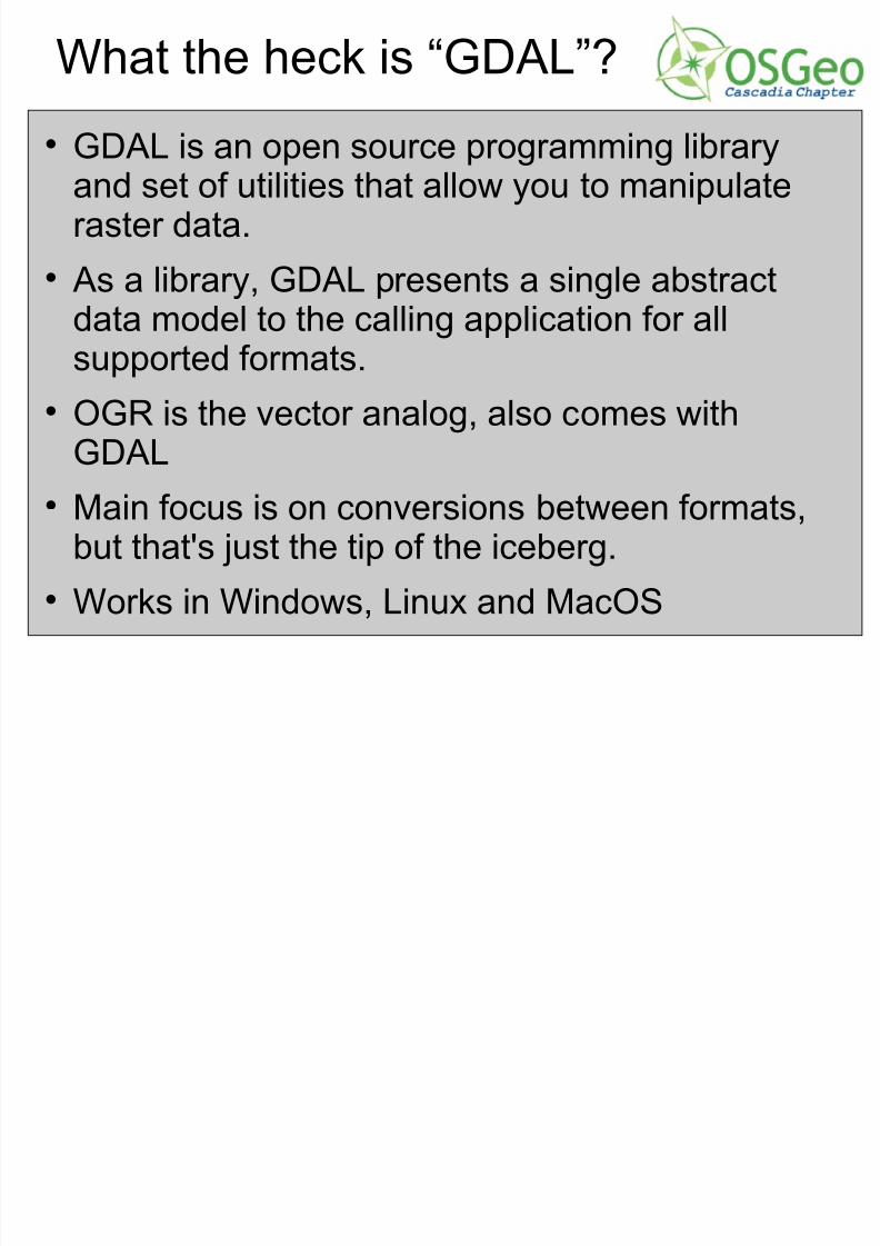
What the heck is “GDAL”?
GDAL is an open source programming libraryand set of utilities that allow you to manipulateraster data.
As a library, GDAL presents a single abstractdata model to the calling application for allsupported formats.
OGR is the vector analog, also comes with
GDAL Main focus is on conversions between formats,
but that's just the tip of the iceberg.
Works in Windows, Linux and MacOS
7/31/2019 Open Source Weds Andre CUGOS
http://slidepdf.com/reader/full/open-source-weds-andre-cugos 3/25
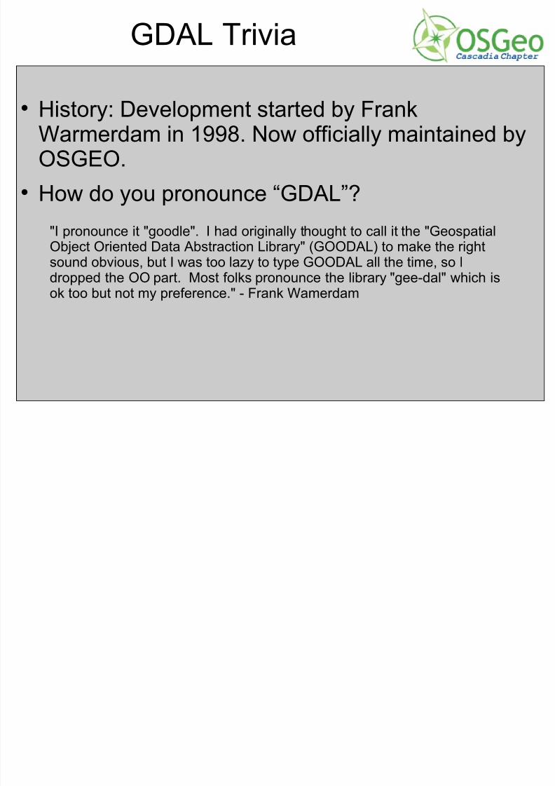
GDAL Trivia
History: Development started by FrankWarmerdam in 1998. Now officially maintained byOSGEO.
How do you pronounce “GDAL”?"I pronounce it "goodle". I had originally thought to call it the "GeospatialObject Oriented Data Abstraction Library" (GOODAL) to make the rightsound obvious, but I was too lazy to type GOODAL all the time, so Idropped the OO part. Most folks pronounce the library "gee-dal" which is
ok too but not my preference." - Frank Wamerdam
7/31/2019 Open Source Weds Andre CUGOS
http://slidepdf.com/reader/full/open-source-weds-andre-cugos 4/25
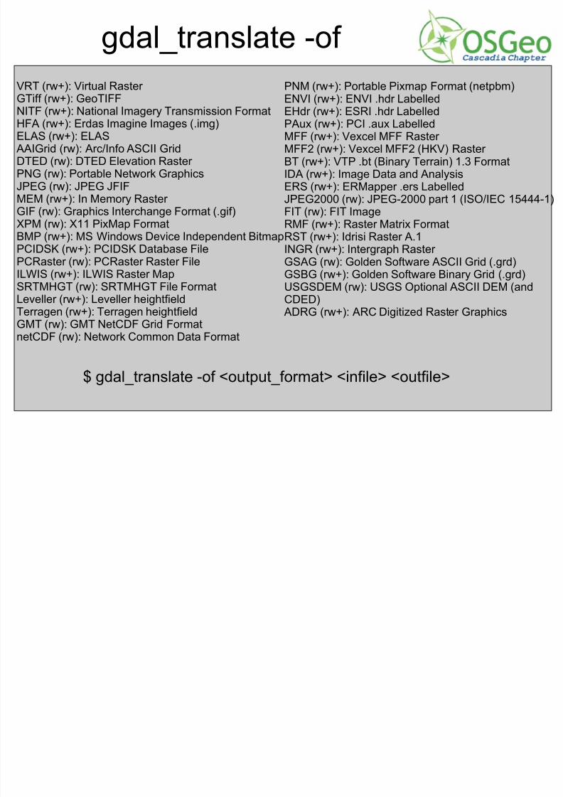
gdal_translate -of
VRT (rw+): Virtual Raster
GTiff (rw+): GeoTIFFNITF (rw+): National Imagery Transmission FormatHFA (rw+): Erdas Imagine Images (.img)ELAS (rw+): ELAS
AAIGrid (rw): Arc/Info ASCII GridDTED (rw): DTED Elevation Raster PNG (rw): Portable Network GraphicsJPEG (rw): JPEG JFIF
MEM (rw+): In Memory Raster GIF (rw): Graphics Interchange Format (.gif)XPM (rw): X11 PixMap FormatBMP (rw+): MS Windows Device Independent BitmapPCIDSK (rw+): PCIDSK Database FilePCRaster (rw): PCRaster Raster FileILWIS (rw+): ILWIS Raster MapSRTMHGT (rw): SRTMHGT File FormatLeveller (rw+): Leveller heightfieldTerragen (rw+): Terragen heightfieldGMT (rw): GMT NetCDF Grid FormatnetCDF (rw): Network Common Data Format
PNM (rw+): Portable Pixmap Format (netpbm)
ENVI (rw+): ENVI .hdr LabelledEHdr (rw+): ESRI .hdr LabelledPAux (rw+): PCI .aux LabelledMFF (rw+): Vexcel MFF Raster MFF2 (rw+): Vexcel MFF2 (HKV) Raster BT (rw+): VTP .bt (Binary Terrain) 1.3 FormatIDA (rw+): Image Data and AnalysisERS (rw+): ERMapper .ers Labelled
JPEG2000 (rw): JPEG-2000 part 1 (ISO/IEC 15444-1)FIT (rw): FIT ImageRMF (rw+): Raster Matrix FormatRST (rw+): Idrisi Raster A.1INGR (rw+): Intergraph Raster GSAG (rw): Golden Software ASCII Grid (.grd)GSBG (rw+): Golden Software Binary Grid (.grd)USGSDEM (rw): USGS Optional ASCII DEM (andCDED)
ADRG (rw+): ARC Digitized Raster Graphics
$ gdal_translate -of <output_format> <infile> <outfile>
7/31/2019 Open Source Weds Andre CUGOS
http://slidepdf.com/reader/full/open-source-weds-andre-cugos 5/25
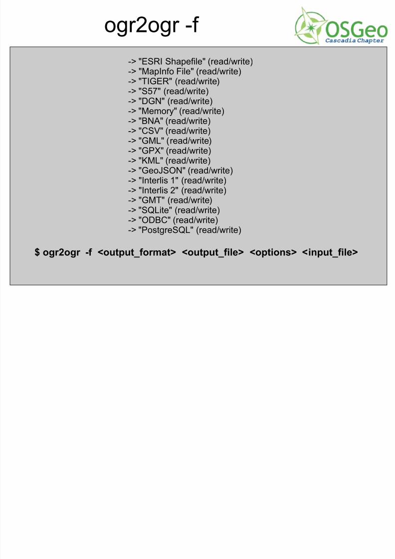
ogr2ogr -f
-> "ESRI Shapefile" (read/write)
-> "MapInfo File" (read/write)-> "TIGER" (read/write)-> "S57" (read/write)-> "DGN" (read/write)-> "Memory" (read/write)-> "BNA" (read/write)-> "CSV" (read/write)
-> "GML" (read/write)-> "GPX" (read/write)-> "KML" (read/write)-> "GeoJSON" (read/write)-> "Interlis 1" (read/write)-> "Interlis 2" (read/write)-> "GMT" (read/write)-> "SQLite" (read/write)-> "ODBC" (read/write)-> "PostgreSQL" (read/write)
$ ogr2ogr -f <output_format> <output_file> <options> <input_file>
7/31/2019 Open Source Weds Andre CUGOS
http://slidepdf.com/reader/full/open-source-weds-andre-cugos 6/25
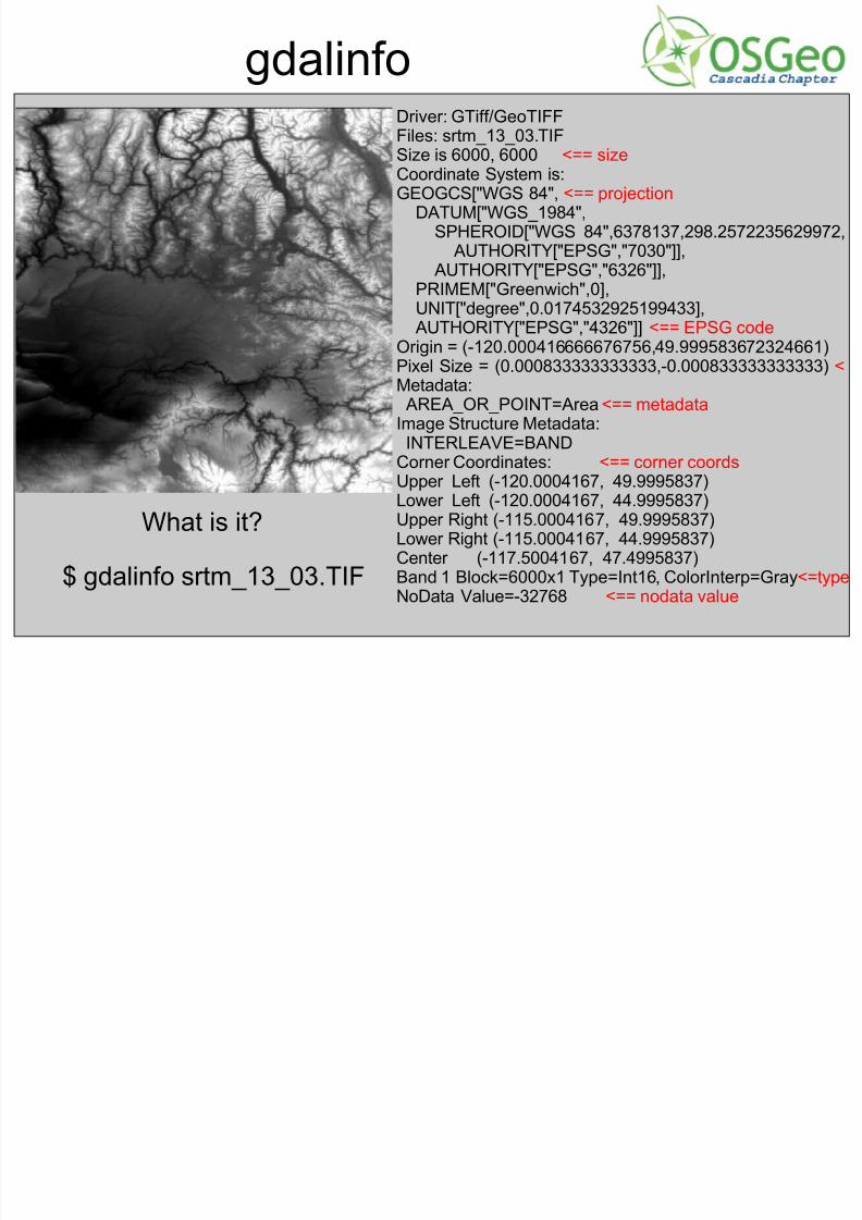
gdalinfoDriver: GTiff/GeoTIFFFiles: srtm_13_03.TIF
Size is 6000, 6000 <== sizeCoordinate System is:GEOGCS["WGS 84", <== projection
DATUM["WGS_1984",SPHEROID["WGS 84",6378137,298.2572235629972,
AUTHORITY["EPSG","7030"]],AUTHORITY["EPSG","6326"]],
PRIMEM["Greenwich",0],UNIT["degree",0.0174532925199433],AUTHORITY["EPSG","4326"]] <== EPSG code
Origin = (-120.000416666676756,49.999583672324661)Pixel Size = (0.000833333333333,-0.000833333333333) <Metadata:AREA_OR_POINT=Area <== metadata
Image Structure Metadata:
INTERLEAVE=BANDCorner Coordinates: <== corner coordsUpper Left (-120.0004167, 49.9995837)Lower Left (-120.0004167, 44.9995837)Upper Right (-115.0004167, 49.9995837)Lower Right (-115.0004167, 44.9995837)Center (-117.5004167, 47.4995837)Band 1 Block=6000x1 Type=Int16, ColorInterp=Gray<=type
NoData Value=-32768 <== nodata value
What is it?
$ gdalinfo srtm_13_03.TIF
7/31/2019 Open Source Weds Andre CUGOS
http://slidepdf.com/reader/full/open-source-weds-andre-cugos 7/25
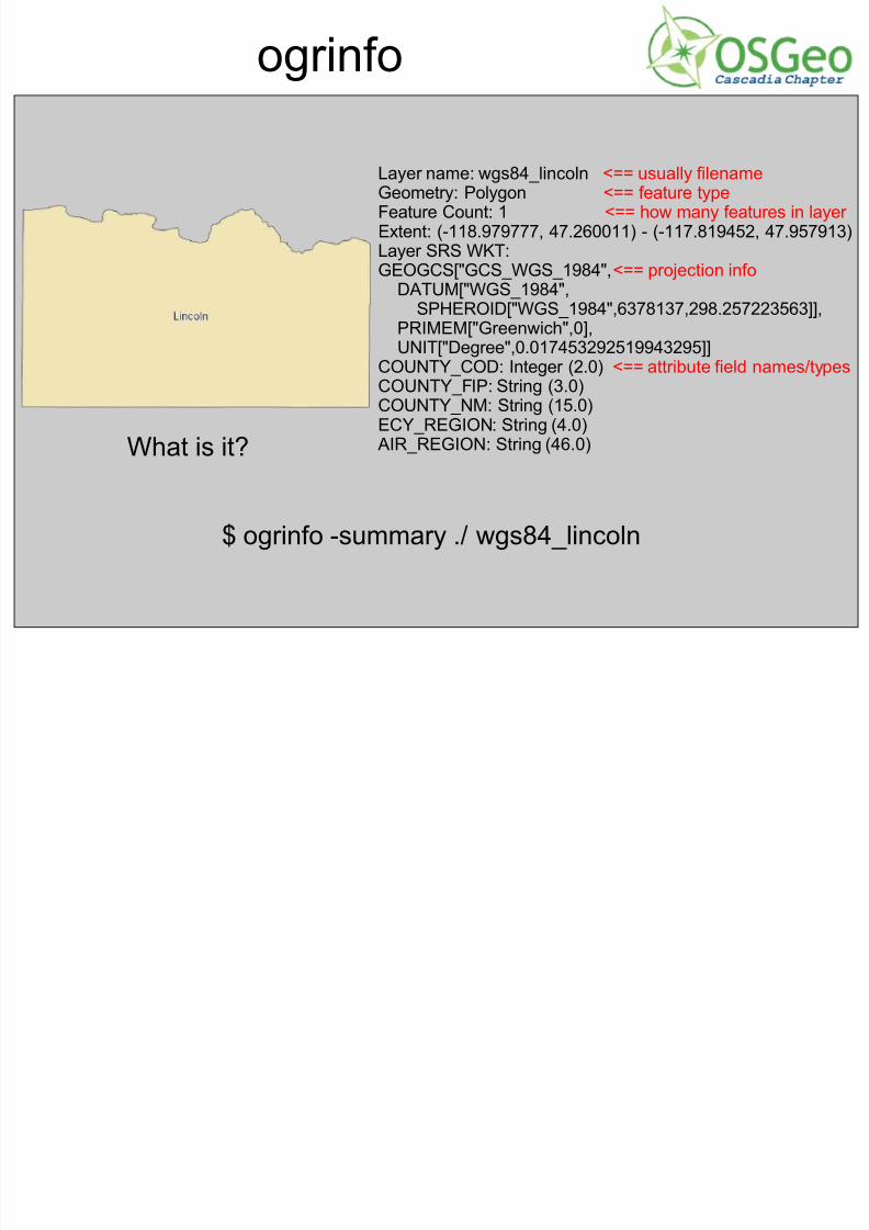
ogrinfo
Layer name: wgs84_lincoln <== usually filenameGeometry: Polygon <== feature typeFeature Count: 1 <== how many features in layer Extent: (-118.979777, 47.260011) - (-117.819452, 47.957913)Layer SRS WKT:GEOGCS["GCS_WGS_1984",<== projection info
DATUM["WGS_1984",
SPHEROID["WGS_1984",6378137,298.257223563]],PRIMEM["Greenwich",0],UNIT["Degree",0.017453292519943295]]
COUNTY_COD: Integer (2.0) <== attribute field names/typesCOUNTY_FIP: String (3.0)COUNTY_NM: String (15.0)ECY_REGION: String (4.0)
AIR_REGION: String (46.0)
What is it?
$ ogrinfo -summary ./ wgs84_lincoln
7/31/2019 Open Source Weds Andre CUGOS
http://slidepdf.com/reader/full/open-source-weds-andre-cugos 8/25
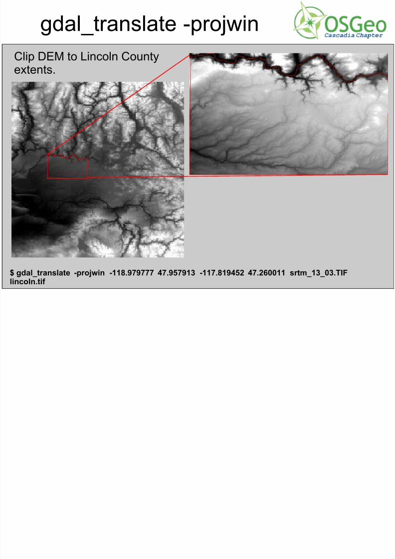
gdal_translate -projwin
Clip DEM to Lincoln County
extents.
$ gdal_translate -projwin -118.979777 47.957913 -117.819452 47.260011 srtm_13_03.TIFlincoln.tif
7/31/2019 Open Source Weds Andre CUGOS
http://slidepdf.com/reader/full/open-source-weds-andre-cugos 9/25
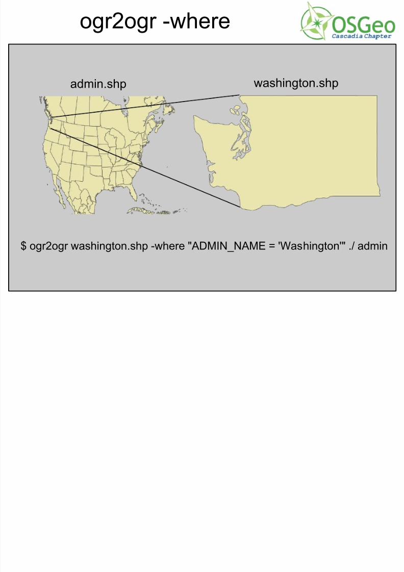
ogr2ogr -where
$ ogr2ogr washington.shp -where "ADMIN_NAME = 'Washington'" ./ admin
admin.shp washington.shp
7/31/2019 Open Source Weds Andre CUGOS
http://slidepdf.com/reader/full/open-source-weds-andre-cugos 10/25
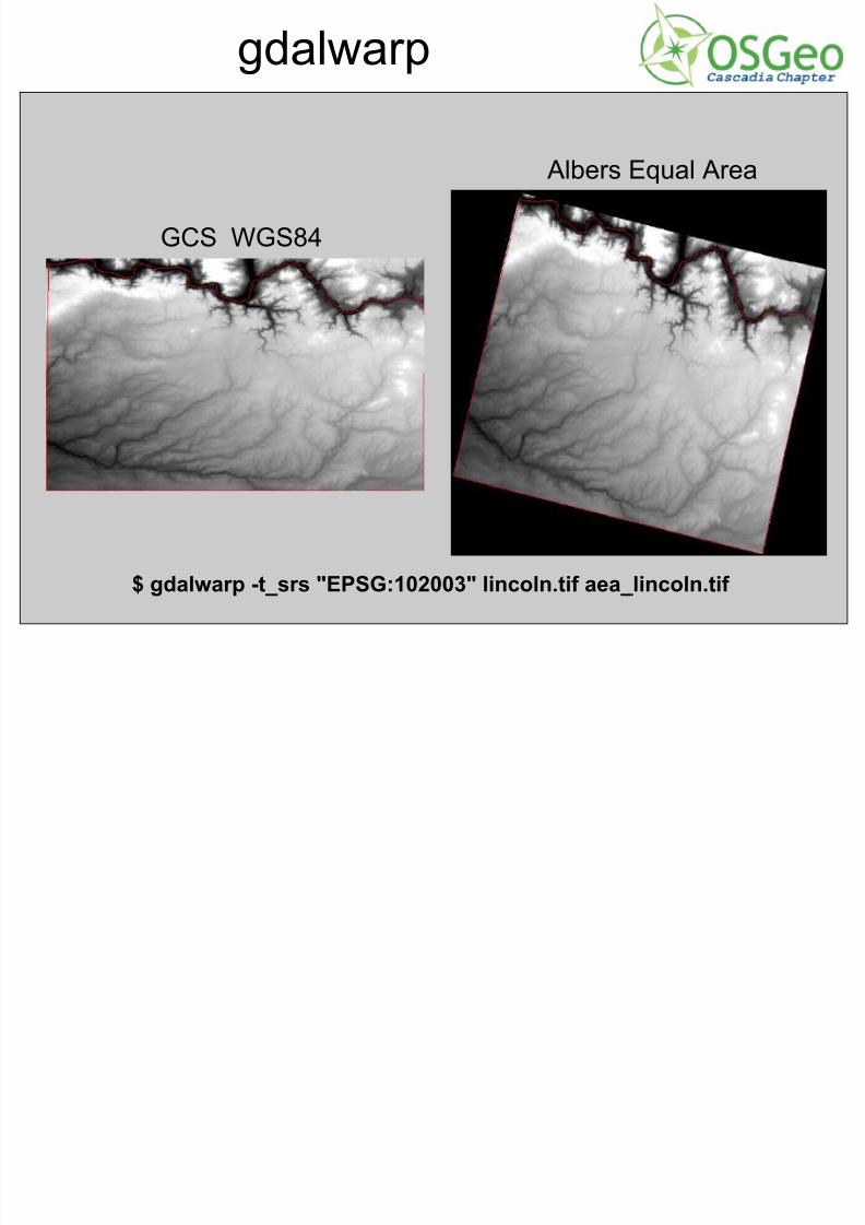
gdalwarp
GCS WGS84
Albers Equal Area
$ gdalwarp -t_srs "EPSG:102003" lincoln.tif aea_lincoln.tif
7/31/2019 Open Source Weds Andre CUGOS
http://slidepdf.com/reader/full/open-source-weds-andre-cugos 11/25
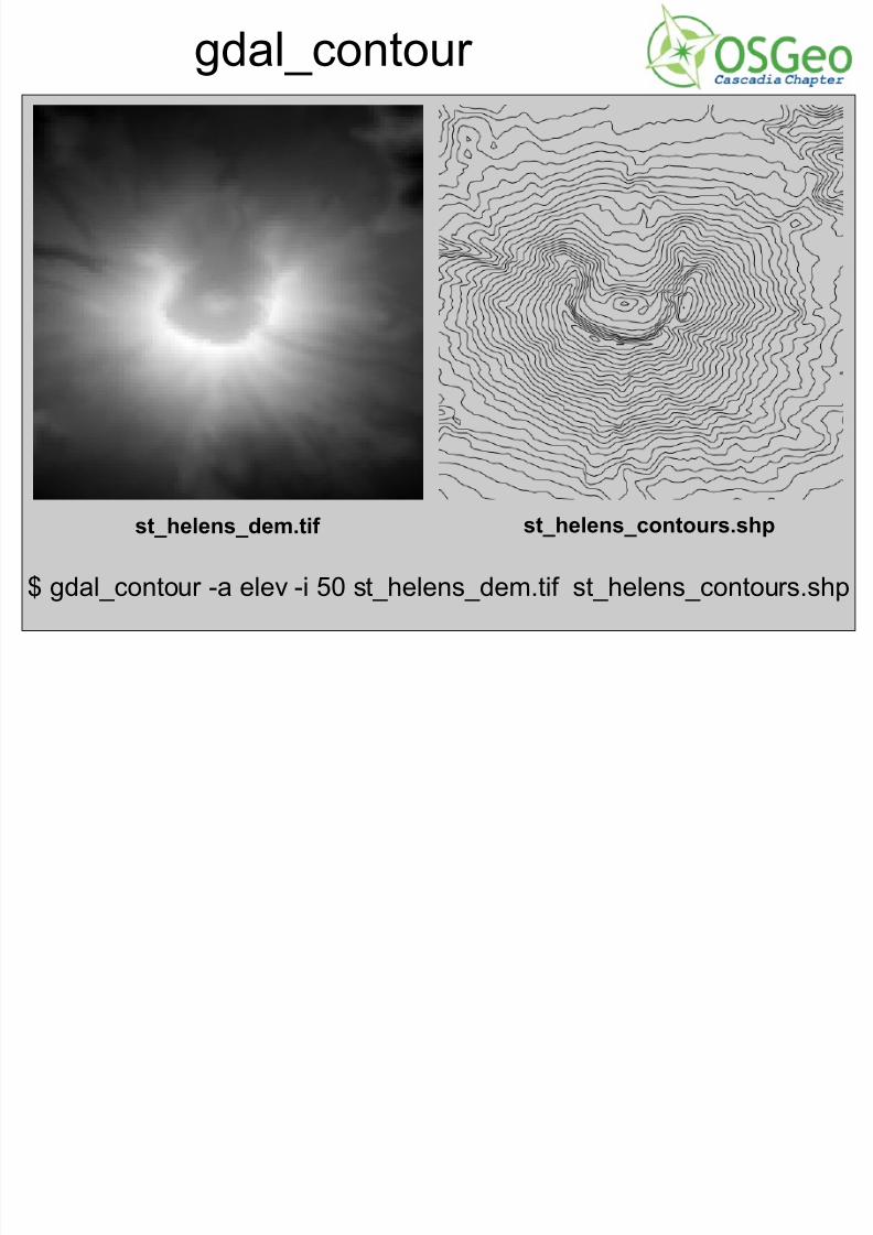
gdal_contour
st_helens_dem.tif st_helens_contours.shp
$ gdal_contour -a elev -i 50 st_helens_dem.tif st_helens_contours.shp
7/31/2019 Open Source Weds Andre CUGOS
http://slidepdf.com/reader/full/open-source-weds-andre-cugos 12/25
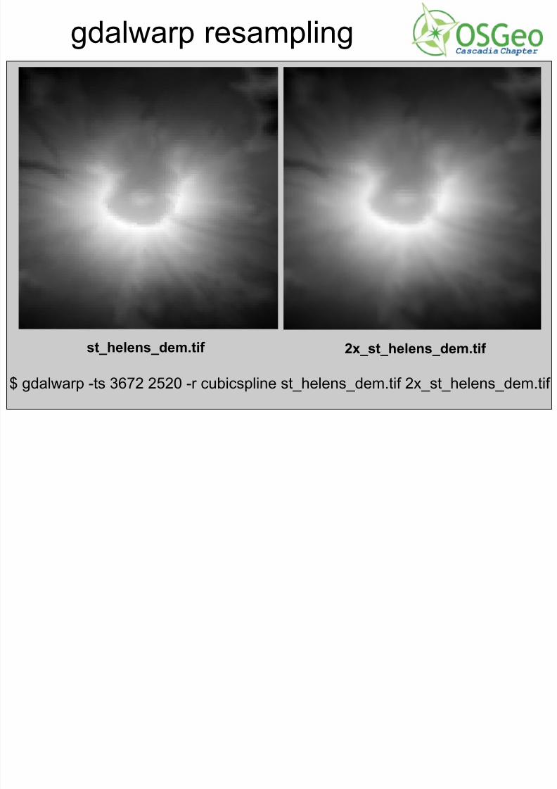
gdalwarp resampling
st_helens_dem.tif 2x_st_helens_dem.tif
$ gdalwarp -ts 3672 2520 -r cubicspline st_helens_dem.tif 2x_st_helens_dem.tif
7/31/2019 Open Source Weds Andre CUGOS
http://slidepdf.com/reader/full/open-source-weds-andre-cugos 13/25
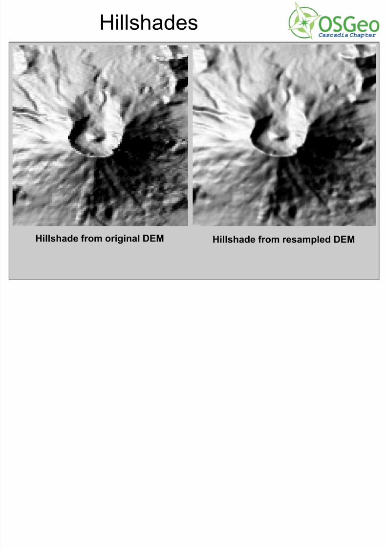
Hillshades
Hillshade from original DEM Hillshade from resampled DEM
7/31/2019 Open Source Weds Andre CUGOS
http://slidepdf.com/reader/full/open-source-weds-andre-cugos 14/25
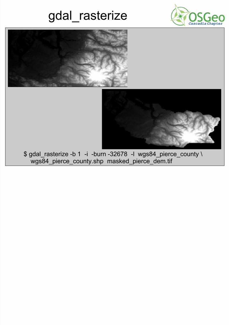
gdal_rasterize
$ gdal_rasterize -b 1 -i -burn -32678 -l wgs84_pierce_county \
wgs84_pierce_county.shp masked_pierce_dem.tif
7/31/2019 Open Source Weds Andre CUGOS
http://slidepdf.com/reader/full/open-source-weds-andre-cugos 15/25
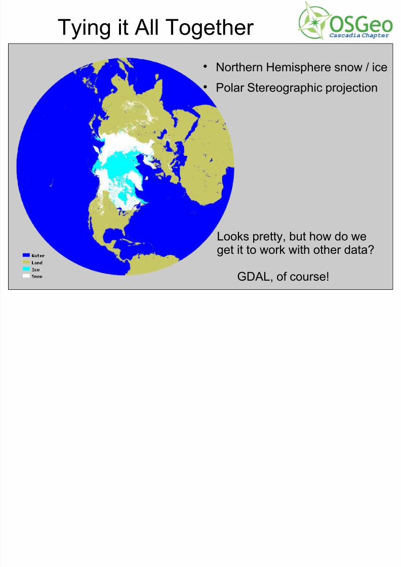
Tying it All Together
Northern Hemisphere snow / ice Polar Stereographic projection
Looks pretty, but how do weget it to work with other data?
GDAL, of course!
7/31/2019 Open Source Weds Andre CUGOS
http://slidepdf.com/reader/full/open-source-weds-andre-cugos 16/25
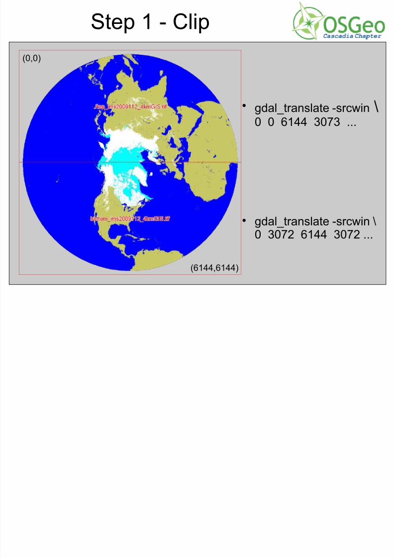
Step 1 - Clip
gdal_translate -srcwin \0 0 6144 3073 ...
gdal_translate -srcwin \0 3072 6144 3072 ...
(0,0)
(6144,6144)
7/31/2019 Open Source Weds Andre CUGOS
http://slidepdf.com/reader/full/open-source-weds-andre-cugos 17/25
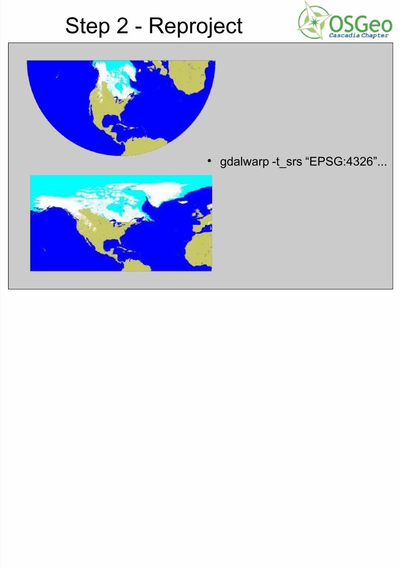
Step 2 - Reproject
gdalwarp -t_srs “EPSG:4326”...
7/31/2019 Open Source Weds Andre CUGOS
http://slidepdf.com/reader/full/open-source-weds-andre-cugos 18/25
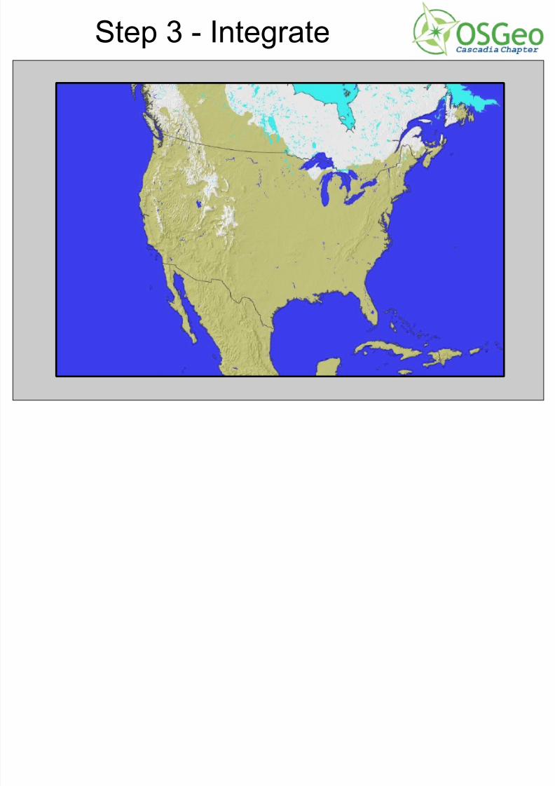
Step 3 - Integrate
7/31/2019 Open Source Weds Andre CUGOS
http://slidepdf.com/reader/full/open-source-weds-andre-cugos 19/25
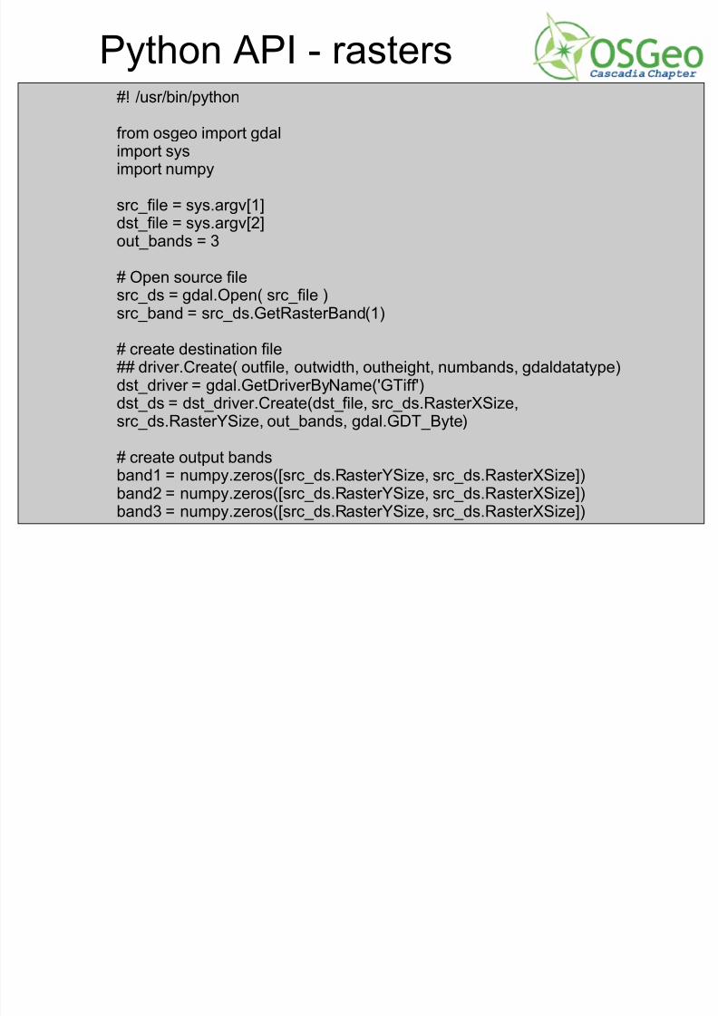
Python API - rasters#! /usr/bin/python
from osgeo import gdalimport sysimport numpy
src_file = sys.argv[1]dst_file = sys.argv[2]out_bands = 3
# Open source filesrc_ds = gdal.Open( src_file )src_band = src_ds.GetRasterBand(1)
# create destination file## driver.Create( outfile, outwidth, outheight, numbands, gdaldatatype)
dst_driver = gdal.GetDriverByName('GTiff')dst_ds = dst_driver.Create(dst_file, src_ds.RasterXSize,src_ds.RasterYSize, out_bands, gdal.GDT_Byte)
# create output bandsband1 = numpy.zeros([src_ds.RasterYSize, src_ds.RasterXSize])band2 = numpy.zeros([src_ds.RasterYSize, src_ds.RasterXSize])band3 = numpy.zeros([src_ds.RasterYSize, src_ds.RasterXSize])
7/31/2019 Open Source Weds Andre CUGOS
http://slidepdf.com/reader/full/open-source-weds-andre-cugos 20/25
Python - rasters (cont)
# set the projection and georeferencing info
dst_ds.SetProjection( src_ds.GetProjection() )dst_ds.SetGeoTransform( src_ds.GetGeoTransform() )
# read the source filefor iY in range(src_ds.RasterYSize):src_data = src_band.ReadAsArray(0,iY,src_ds.RasterXSize,1)col_values = src_data[0] # array of z_values, one per row in source
datafor iX in range(src_ds.RasterXSize):
z_value = col_values[iX][R,G,B] = MakeColor(z_value)band1[iY][iX] = Rband2[iY][iX] = Gband3[iY][iX] = B
# write each band outdst_ds.GetRasterBand(1).WriteArray(band1)dst_ds.GetRasterBand(2).WriteArray(band2)dst_ds.GetRasterBand(3).WriteArray(band3)
dst_ds = None
7/31/2019 Open Source Weds Andre CUGOS
http://slidepdf.com/reader/full/open-source-weds-andre-cugos 21/25
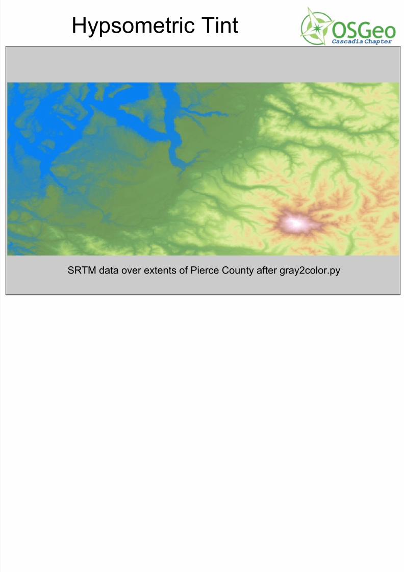
Hypsometric Tint
SRTM data over extents of Pierce County after gray2color.py
7/31/2019 Open Source Weds Andre CUGOS
http://slidepdf.com/reader/full/open-source-weds-andre-cugos 22/25
Python API - vectors
"""Merge a group of shapefiles into one new one."""
import sysimport globfrom osgeo import ogr
outfile = "merge.shp"
file_list = glob.glob("*.shp")
# CREATE OUTPUT FILEout_driver = ogr.GetDriverByName( 'ESRI Shapefile' )out_ds = out_driver.CreateDataSource(outfile)out_srs = Noneout_layer = out_ds.CreateLayer("trans", out_srs, ogr.wkbLineString)
fd = ogr.FieldDefn('name', ogr.OFTString)out_layer.CreateField(fd)fd = ogr.FieldDefn('kV', ogr.OFTInteger)out_layer.CreateField(fd)
cont. on next slide
7/31/2019 Open Source Weds Andre CUGOS
http://slidepdf.com/reader/full/open-source-weds-andre-cugos 23/25
Python API - vectors (cont)# READ EACH INPUT FILE AND WRITE FIELDS TO NEW FILEfor shapefile in file_list:
print shapefile[filename, extension] = shapefile.split('.')in_drv = ogr.GetDriverByName( 'ESRI Shapefile' )in_ds = in_drv.Open(shapefile)in_layer = in_ds.GetLayer(0)in_feature = in_layer.GetNextFeature()kV_field = in_feature.GetFieldIndex('kV')
counter = 1while in_feature is not None:name = filename + "_" + `counter`kV = in_feature.GetField(kV_field)out_feat = ogr.Feature(out_layer.GetLayerDefn())out_feat.SetField('name', name)out_feat.SetField('kV', kV)
out_feat.SetGeometry(in_feature.GetGeometryRef().Clone())out_layer.CreateFeature(out_feat)out_layer.SyncToDisk()out_feat.Destroy()in_feature.Destroy()in_feature = in_layer.GetNextFeature()counter += 1
out_ds.Destroy()
7/31/2019 Open Source Weds Andre CUGOS
http://slidepdf.com/reader/full/open-source-weds-andre-cugos 24/25
Combine the 2 types!
Because gdal/ogr can read both raster andvectors, it's possible to do some interestingcombined processing tasks via the Python API.
Contour line generation is one example Raster feature vectorizer is another
Be creative, this tool is flexible
Wh t t GDAL / h l
7/31/2019 Open Source Weds Andre CUGOS
http://slidepdf.com/reader/full/open-source-weds-andre-cugos 25/25
Where to get GDAL / help
http://www.gdal.org/ - main site, has examples for how to use the API, as well as each utility
http://fwtools.maptools.org/ - includes support for some formats which are difficult to work with
http://www.maptools.org/ms4w/ - comes with a tonof other stuff as well
[email protected] - mailing list primarily for
developers, but users welcome as well #gdal irc channel on irc.freenode.net