OFR 2003-15, Geologic Map of the Shelton 1:100,000...
1
Geologic Map of the Shelton 1:100,000 Quadrangle, Washington by Robert L. Logan 2003 1 10 KILOMETERS 0 1 2 4 3 5 6 7 8 9 SCALE 1:100 000 1 8 MILES 1 0 2 3 4 5 6 7 WASHINGTON DIVISION OF GEOLOGY AND EARTH RESOURCES OPEN FILE REPORT 2003-15 Lambert conformal conic projection North American Datum of 1927 Base map information from the Washington Department of Natural Resources Geographic Information System Digital cartography by Anne C. Heinitz, Charles G. Caruthers, and J. Eric Schuster. Editing and production by Karen D. Meyers and Jaretta M. Roloff INTRODUCTION Methods and Nomenclature This map was compiled from previously published geologic maps and unpub- lished thesis maps, and supplemented by reconnaissance field mapping and remote sensing studies using aerial photos, digital elevation models, and Side- Looking Airborne Radar (SLAR) images. Although Quaternary and some bed- rock unit boundaries are commonly diffuse or obscured by heavy vegetation or weathering, they are depicted by solid lines on this map. Geologic unit symbols indicate the age and general rock type of the unit they symbolize and may have a subscript that identifies a formation or a finer age break. Unit symbols for Olympic Mountains–derived alpine glacial deposits were chosen to show relative time of deposition rather than symbolize the unit names assigned by the original mappers. This reduces the need for arbitrary scratch boundaries between indistinguishable units in areas where ice from dif- ferent drainages merged beyond the Olympic Mountains front. Geology Paleocene to Eocene marine sedimentary rocks of the Blue Mountain unit (Tabor and Cady, 1978) are the oldest rocks in the quadrangle. However, Eocene marine volcanic rocks of the Crescent Formation, which overlie and interfinger with the Blue Mountain unit at their base, form the basement throughout most of this quadrangle. In the northwest part of the quadrangle, these two units are sepa- rated from Miocene to Eocene marine sedimentary rocks of the Olympic Penin- sula core by the Southern fault zone (Tabor and Cady, 1978). The Eocene to Oli- gocene Lincoln Creek Formation was deposited on the Crescent Formation basaltic basement rocks. In the Miocene, the Astoria Formation was deposited on the Lincoln Creek Formation, followed by the Montesano Formation in the late Miocene. These units are located in the south-central part of the quadrangle in the northern part of the Grays Harbor sedimentary basin (Snavely and Wag- ner, 1963; Fowler, 1965). All of the bedrock units have been folded and faulted as a result of continued transpression along the western edge of the North Amer- ica plate. Olympic Mountains–derived alpine glacial deposits cover much of the northern and western parts of the map area. The eastern part of the map area is capped by sediments deposited by ice that originated in the northwestern part of the North American continent along the Canadian part of the Cordillera. These glacial deposits are referred to as continental or Cordilleran deposits. Geologic mapping of alpine glacial deposits has historically been either of a regional reconnaissance nature or restricted to discrete drainage basins. As a result of the basin-mapping approach, local names were given to many glacial deposits throughout the southern Olympic Mountains. In this map, an attempt has been made to make approximate age correlations between these locally named units. Previous studies are outlined below and are followed by an explan- ation of the approach used in this map to depict alpine glacial units. Crandell (1964) completed a reconnaissance report in which he described four major alpine glacial advances in the southwest Olympic Mountains. He maintained that three of these advances occurred during Wisconsinan time and one during pre-Wisconsinan time, and that “the only surficial deposit of proba- ble glacial origin beyond the outermost till of Wisconsin age is fluvial gravel”, referring to extensive iron-oxide-stained gravels north of Grays Harbor. He based his age determinations on weathering and physiographic characteristics of the deposits, but his conclusions about the timing of the four alpine glacial advances do not agree with those of later workers. Moore (1965) mapped and named three alpine glacial advances in the Qui- nault River drainage basin. He named his glacial units, from oldest to youngest, the Donkey Creek drift, the Humptulips drift, and the Chow Chow drift. How- ever, he assigned the extensive gravel deposits north of Grays Harbor a pre- Pleistocene age and suggested that these gravels are of nonglacial origin. Carson (1970) mapped and named alpine glacial units in the vicinity of the Wynoochee River based on relative terrace levels, weathering characteristics, and degree of stream dissection. His units from oldest to youngest are the Wede- kind Creek formation, the Mobray drift, and the Grisdale I to VI drifts. He also described a primarily continental glacial drift he named the Helm Creek drift (not shown on this map). He suggested that the Helm Creek drift was deposited sometime after the Wedekind Creek Formation but before a continental glacial drift that he thought was the Salmon Springs Drift. However, his “Salmon Springs” drift was later shown to be the Double Bluff Drift by Easterbrook and others (1981). He also described the Weatherwax formation, which he inter- preted as outwash that was deposited between lobes of the Mobray drift and his “Salmon Springs” drift. Thackray (1996) studied moraines in the Hoh and Queets River drainage basins to the northwest of the Shelton quadrangle, where he also proposed the existence of four alpine ice advances. He provides evidence that the oldest of the drifts, the Wolf Creek, is reversely magnetized, indicating an age of at least 780,000 yr, corresponding to the end of the last magnetic reversal. His next youngest unit, the Whale Creek drift, he assigns to oxygen isotope stage 6, which corresponds to the glaciation immediately preceding the last major inter- glacial period. This roughly corresponds to the Double Bluff Drift of the Puget Lowland at more than 125,000 yr (Thackray, 1996). His Lyman Rapids drift forms outwash terraces that parallel the modern and last interglacial shorelines and are indistinguishable from the older portions of Moore’s Chow Chow out- wash on the basis of rock materials, stratigraphy, geomorphology, and weather- ing characteristics. Thackray assigned late Wisconsinan ages to his youngest alpine drift units, the Twin Creeks and Hoh Oxbow drifts. On this map, units Qapw 1 (drift), Qapwo 1 (outwash), and Qapwt 1 (till) are the oldest pre-Wisconsinan units and include the Wedekind Creek formation and possibly part of the Weatherwax formation of Carson (1970) and the Donkey Creek drift and “moderately to intensely deformed sand and gravel” (north of Grays Harbor) of Moore (1965), and are probably age equivalent to the Wolf Creek drift (Thackray, 1996). Units Qapw 2 , Qapwo 2 , and Qapwt 2 are the younger pre-Wisconsinan units and include unnamed drifts in the East Fork and West Fork Humptulips Rivers, the Mobray drift (Carson, 1970), and the Humptulips drift and “flat lying and slightly deformed sand and gravel” (north of Grays Harbor) of Moore (1965), and are probably age-equivalent to the Whale Creek drift of Thackray (1996). Units Qap, Qapo, and Qapt are pre–late Wisconsinan and include the Gris- dale I and II drifts of Carson (1970), unnamed drifts in the Humptulips River valley, and the older part of Moore’s (1965) Chow Chow drift (southwest of Lake Quinault), and are probably age equivalent to Thackray’s Lyman Rapids drift. The Skokomish Gravel, considered by Molenaar and Noble (1970) to be nonglacial alpine fluvial gravel but interpreted here and by Carson (1979) as alpine outwash, is included in unit Qapo because it is probably much older than the Olympia nonglacial interval (Carson, 1979); all or parts of this unit could be pre-Wisconsinan. The youngest Pleistocene alpine units are Qad, Qao, and Qat and are inter- preted here to include the younger part of the Chow Chow drift of Moore (1965) in the Quinault basin (which constitutes the moraine impounding Lake Qui- nault), the Grisdale III and VI drifts of Carson (1970), a glacial outburst flood deposit in the West Fork Satsop River, and an unnamed drift in the upper reaches of the Skokomish River basin. These units were likely deposited at the same time as the Twin Creeks and Hoh Oxbow drifts (Thackray, 1996) in the Queets and Hoh River basins. Alpine glacial deposits in this quadrangle are derived almost exclusively from the marine sedimentary and volcanic bedrock of the interior of the Olym- pic Peninsula. Beyond the mountain front, other rock types have been, to a very small degree, incorporated into the alpine deposits. In contrast, continental gla- cial deposits characteristically contain granitic and metamorphic rock and abun- dant polycrystalline quartz. Molenaar and Noble (1970) described the continental glacial deposits and provided an overview of the glacial history of southeastern Mason County in the southern Puget Lowland. Their units included deposits of Vashon Stade of the Fraser Glaciation and pre–Vashon Stade glacial and nonglacial units. Carson (1970) mapped the extent of two continental ice advances adjacent to the south- ern Olympic Mountains and suggested that the oldest and most extensive of these deposits correlates with the Salmon Springs Drift near Puyallup. Not until Easterbrook and others (1981) obtained radiometric ages on the Lake Tapps tephra in the Puget Lowland was it recognized that the Salmon Springs deposits were older than previously thought and that at least two glacial advances, the Possession and Double Bluff, were not represented in the stratigraphy of the Puyallup site. Easterbrook and others (1981) maintained that because the Pos- session Drift advanced only as far south as Tacoma, Carson’s “Salmon Springs” drift is more likely the Double Bluff Drift. ACKNOWLEDGMENTS Special thanks are given to Glenn Thackray (Idaho State Univ.), Bob Carson (Whitman College), and Wendy Gerstel (Wash. State Dept. of Natural Resour- ces) for discussions about the Quaternary stratigraphy of the western Olympic Peninsula; Bill Lingley, Tim Walsh, Hank Schasse, and Weldon Rau (all of Wash. State Dept. of Natural Resources) and Park Snavely, Jr. (U.S. Geological Survey) for mapping and discussions of the Tertiary bedrock; Rowland Tabor and Wallace Cady (both of U.S. Geological Survey) for their geologic map of the Olympic Peninsula (Tabor and Cady, 1978); and the Quinault Tribe for allowing access to the lower reaches of the Quinault basin. I would also like to thank Washington Department of Natural Resources staff members Karen Mey- ers and Jari Roloff for their editorial reviews; Anne Heinitz, Chuck Caruthers, and Eric Schuster for their cartographic support; and Connie Manson and Lee Walkling for their library research support. This project was funded in part by the National Cooperative Geologic Mapping Program through Cooperative Agreement No. 98QAG2062. REFERENCES Brandon, M. T.; Vance, J. A., 1992, Tectonic evolution of the Cenozoic Olympic subduction complex, Washington State, as deduced from fission track ages for detrital zircons: American Journal of Science, v. 292, no. 8, p. 565-636. Carson, R. J., 1970, Quaternary geology of the south-central Olympic Peninsula, Washington: University of Washington Doctor of Philosophy thesis, 67 p., 4 plates. Carson, R. J., 1976, Geologic map of north-central Mason County, Washington: Washington Division of Geology and Earth Resources Open File Report 76- 2, 1 sheet, scale 1:62,500. Carson, R. J., 1979, Reinterpretation of the Skokomish gravel, southwestern Puget Lowland, Washington [abstract]: Northwest Scientific Association, Annual Meeting, 52nd, Program and Abstracts, p. 31. Crandell, D. R., 1964, Pleistocene glaciations of the southwestern Olympic Peninsula, Washington: U.S. Geological Survey Professional Paper 501-B, p. B135-B139. Easterbrook, D. J., 1985, Correlation of Pleistocene deposits in the northwestern U.S. [abstract]: Geological Society of America Abstracts with Programs, v. 17, no. 7, p. 571. Easterbrook, D. J.; Briggs, N. D.; Westgate, J. A.; Gorton, M. P., 1981, Age of the Salmon Springs glaciation in Washington: Geology, v. 9, no. 2, p. 87-93. Fowler, G. A., 1965, The stratigraphy, foraminifera and paleoecology of the Montesano Formation, Grays Harbor County, Washington: University of Southern California Doctor of Philosophy thesis, 355 p. Molenaar, Dee; Noble, J. B., 1970, Geology and related ground-water occurrence, southeastern Mason County, Washington: Washington Department of Water Resources Water-Supply Bulletin 29, 145 p., 2 plates. Moore, J. L., 1965, Surficial geology of the southwestern Olympic Peninsula: University of Washington Master of Science thesis, 63 p., 1 plate. Porter, S. C., 1970, Glacier recession in the southern and central Puget Lowland, Washington, between 14,000 and 13,000 years B.P. [abstract]: American Quaternary Association, Meeting, 1st, p. 107. Rau, W. W., 1966, Stratigraphy and foraminifera of the Satsop River area, southern Olympic Peninsula, Washington: Washington Division of Mines and Geology Bulletin 53, 66 p., 8 plates. Rau, W. W., 1967, Geology of the Wynoochee Valley quadrangle, Grays Harbor County, Washington: Washington Division of Mines and Geology Bulletin 56, 51 p., 1 plate. Rau, W. W., 1973, Geology of the Washington coast between Point Grenville and the Hoh River: Washington Division of Geology and Earth Resources Bulletin 66, 58 p. Rau, W. W., 1981, Pacific Northwest Tertiary benthic foraminiferal biostratigraphic framework—An overview. In Armentrout, J. M., editor, Pacific Northwest Cenozoic biostratigraphy: Geological Society of America Special Paper 184, p. 67-84. Rau, W. W., 1984, The Humptulips Formation—A new Eocene formation of southwest Washington: Washington Geologic Newsletter, v. 12, no. 4, p. 1-5. Rau, W. W., 1986, Geologic map of the Humptulips quadrangle and adjacent areas, Grays Harbor County, Washington: Washington Division of Geology and Earth Resources Geologic Map GM-33, 1 sheet, scale 62,500. Rigg, G. B., 1958, Peat resources of Washington: Washington Division of Mines and Geology Bulletin 44, 272 p. Schuster, R. L.; Logan, R. L.; Pringle, P. T., 1992, Prehistoric rock avalanches in the Olympic Mountains, Washington: Science, v. 258, no. 5088, p. 1620- 1621. Snavely, P. D., Jr.; Brown, R. D., Jr.; Roberts, A. E.; Rau, W. W., 1958, Geology and coal resources of the Centralia–Chehalis district, Washington, with a section on Microscopical character of Centralia–Chehalis coal, by J. M. Schopf: U.S. Geological Survey Bulletin 1053, 159 p., 6 plates. Snavely, P. D., Jr.; Wagner, H. C., 1963, Tertiary geologic history of western Oregon and Washington: Washington Division of Mines and Geology Report of Investigations 22, 25 p. Tabor, R. W.; Cady, W. M., 1978, Geologic map of the Olympic Peninsula, Washington: U.S. Geological Survey Miscellaneous Investigations Series Map I-994, 2 sheets, scale 1:125,000. Thackray, G. D., 1996, Glaciation and neotectonic deformation on the western Olympic Peninsula, Washington: University of Washington Doctor of Philosophy thesis, 139 p., 2 plates. DESCRIPTION OF MAP UNITS Quaternary Sediments NONGLACIAL DEPOSITS Qa Alluvium (Holocene)—Sorted combinations of silt, sand, and gravel deposited in streambeds and alluvial fans; clasts are generally rounded and composed of sandstone, derived either from local bed- rock sources or from reworked Olympic Peninsula (alpine) and Puget Lowland (continental) glacial deposits; locally may include alpine drift, peat, lacustrine, or landslide deposits; surface is undissected by streams relative to pre-Holocene terrace surfaces. Qls Landslide deposits (Holocene)—Poorly sorted mixtures of locally derived rock and (or) soil emplaced by mass-wasting processes; deposits vary widely in size, composition, and mode of emplacement; only the largest landslides are shown; includes rock falls (Schuster and others, 1992) in the southeast Olympic Peninsula that are proba- bly seismically induced, and large deep-seated landslides along Hood Canal (Carson, 1976) and along steep-sided inner gorges of river val- leys in the southern Olympics; smaller shallow deposits such as debris flows in steep mountain drainages and rock topples along coastal bluffs, although numerous and dangerous, are too small to show at the map scale. Qp Peat (Holocene)—Fibrous peat, woody peat, muck, lake mud, and sphagnum; fibrous peat is light to dark brown to reddish brown, muck is black, and lake mud and woody peat are steel gray (Rigg, 1958). Qc Undifferentiated sedimentary deposits (Pleistocene)—Silt and fine sand with interbedded, radiocarbon-infinite peat and organic hash lay- ers; generally tens of feet thick; nonindurated; olive-brown where oxidized to blue-gray where fresh; locally interbedded with or under- lying the Skokomish Gravel and locally contains dropstones; may contain both glacial and nonglacial components. ALPINE GLACIAL DEPOSITS Qad Alpine drift, late Wisconsinan (Pleistocene)—Undifferentiated medium-gray till and outwash sand and gravel with little to no weath- ering apparent; clasts consist mostly of local sandstone and basalt; may contain alluvium, colluvium, landslide debris, and peat; gener- ally restricted to upper reaches of valleys in the Olympic Mountains. Qat Alpine till, late Wisconsinan (Pleistocene)—Compact, poorly sorted mixture of silt, sand, gravel, and rare boulders; light gray; clasts larger than pebble size are commonly faceted and striated; sand frac- tion is generally very angular; composed mostly of Crescent Forma- tion basalt but may also contain sedimentary and low-grade metasedi- mentary rocks from the interior of the Olympic Mountains; most commonly occurs as 1 to 2 ft thick layers of lodgment till on bedrock, but also occurs in apparently much thicker pockets; many outcrops are not extensive enough to show at map scale. Qao Alpine outwash, late Wisconsinan (Pleistocene)—Stratified sand and gravel derived from Crescent Formation basalt or sandstone of the Olympic Mountains; may contain other local rock types in lower reaches of Olympic streams; locally contains silt and clay; generally not deeply weathered; composes lower stream terraces; stream dissec- tion of terrace surfaces is poorly developed. Qap Alpine drift, pre–late Wisconsinan (Pleistocene)—Undifferentiated till and outwash sand and gravel; gray with local orange weathering; locally covered with cream-colored weathered loess; consists of mostly ground and end moraine. Qapo Alpine outwash, pre–late Wisconsinan (Pleistocene)—Stratified sand, gravel, and cobbles; in the Quinault basin, clasts consist of sandstone and less-abundant basalt from the Olympic Mountains core and peripheral rocks; in streams draining the southern and southeast- ern Olympics, clasts consist primarily of Crescent Formation basalt with less-abundant Olympic-core sandstone; may include peat, silt, and clay, and may be capped by weathered loess; clasts are generally more rounded than those in till and lack facets and striations; poorly to moderately sorted; gray to subtle yellow with wispy orange weath- ering. Qapt Alpine till, pre–late Wisconsinan (Pleistocene)—Compact, gray to brown, poorly sorted mixture of silt, sand, gravel, and boulders of local provenance found at lower elevations along the north side of Quinault Ridge; occurs as lodgment till covering bedrock; small-size fraction is very angular; larger-size fraction is commonly faceted and striated; may also contain older till. Qapw 2 Alpine drift, younger pre-Wisconsinan (Pleistocene)—Undifferen- tiated till, outwash sand and gravel, lacustrine silt and clay, and loess; clasts are composed primarily of basalt and sandstone from peripheral and core rocks of the Olympic Peninsula; weathered to depths exceeding 12 ft; red-orange weathering rinds on clasts; ancient surfa- ces are moderately dissected by streams; locally covered with a well- developed soil and strongly incised by streams, indicating possibly greater age. Qapwt 2 Alpine till, younger pre-Wisconsinan (Pleistocene)—Compact mix- ture of silt, sand, and gravel; may contain some faceted and striated boulders; may also contain outwash or loess; deeply weathered to brownish red; located along the north side of the Quinault River val- ley; true age unknown; mapped by Moore (1965) as Humptulips till and drift. Qapwo 2 Alpine outwash, younger pre-Wisconsinan (Pleistocene)—Sand and gravel composed of sandstone and basalt derived from the core of the Olympic Mountains; clasts are generally moderately to well rounded with characteristic red-orange weathering rinds; poorly to moderately sorted; weathered to depths exceeding 12 ft. Qapw 1 Alpine drift, older pre-Wisconsinan (Pleistocene)—Undifferen- tiated till, outwash sand and gravel, and lacustrine silt and clay; deep red-orange; weathered to depths exceeding 60 ft with clasts thor- oughly weathered; ancient moraine surfaces are highly dissected by streams. Qapwt 1 Alpine till, older pre-Wisconsinan (Pleistocene)—Compact, non- sorted mixture of clay, silt, sand, and gravel with boulders; larger clasts are faceted and striated, and are locally angular due to short transport distances; sand-size fraction is very angular; clasts consist of locally derived basalt; shown schematically on map in upper reaches of hanging valleys on north side of Quinault Ridge, where pockets of locally derived till are present in ravine bottoms and side channels and locally covered with colluvium. Qapwo 1 Alpine outwash, older pre-Wisconsinan (Pleistocene)—Sand and pebble gravel with local beds of coarse gravel and silt; so deeply weathered that clasts can be cut by a knife; iron oxide imparts red- dish-brown color and a moderate degree of cementation to the grav- els; extensive deposits scattered along the southern and western flanks of the Olympic Mountains suggest a glacial origin. CONTINENTAL GLACIAL DEPOSITS Fraser Glaciation, Vashon Stade Qgo Proglacial and recessional outwash, late Wisconsinan (Pleisto- cene)—Typically poorly to moderately sorted, rounded gravel and sand with localized coarser- and finer-grained constituents; lithologi- cally varied mixture of mostly northern-provenance clasts, especially containing granitic and metamorphic rocks that identify the unit as being deposited by the Puget lobe of the Cordilleran glacier; also con- tains varying amounts of locally derived Crescent Formation basalt, and in the Mox Chehalis Creek valley, central Cascade Range– derived andesitic clasts; typically shades of gray where fresh or brown where stained especially in proglacial and morainal areas; buff staining near the ground surface; fine sand, silt, and clay constitute local overbank sediments having relatively poor permeability or del- taic foreset bedding along north sides of valleys with higher permea- bility; porous and permeable enough to yield small to moderate quan- tities of groundwater; very poorly consolidated to loose; moderately to well-rounded clasts; mostly unweathered with rare weathered reworked clasts; thickness varies and is not well known; most com- monly occupies outwash channels scoured into or through till. Qgd Drift, late Wisconsinan (Pleistocene)—Undifferentiated till and out- wash sand and gravel of mostly northern provenance; contains gran- itic and metamorphic clasts and abundant polycrystalline quartz char- acteristic of sediments deposited by the Puget lobe of the Cordilleran glacier; minor locally derived Crescent Formation basalt may also be present; may contain clay, silt, sand, gravel, or rare boulders; light gray where fresh with rare reworked weathered clasts and local yel- low to brown mineral staining; may be stratified or nonstratified; compact to loose; may occur as morainal ridges; contains mixtures of till and outwash not separately mappable; clasts in till are rounded, faceted, and (or) striated; clasts in outwash are sub- to well-rounded; finer-grained fraction is angular in till versus sub- to well-rounded in outwash; age of maximum ice advance in map area has been esti- mated to be 14,000 yr (Porter, 1970) to 12,600 yr (Carson, 1970). Qgt Till, late Wisconsinan (Pleistocene)—Unsorted, unstratified, highly compacted mixture of clay, silt, sand, gravel, and boulders deposited by glacial ice of the Puget lobe; gray; may contain interbedded strati- fied sand, silt, and gravel; sand-size fraction is very angular and con- tains abundant polycrystalline quartz, which distinguishes this unit from alpine till; cobbles and boulders are commonly striated and (or) faceted; although unweathered almost everywhere, may contain cob- bles or small boulders of deeply weathered granitic rock. Qga Advance outwash, late Wisconsinan (Pleistocene)—Glaciofluvial sand and gravel and lacustrine clay, silt, and sand deposited during the advance of glaciers; sandy units commonly thick, well sorted, and fine grained, with interlayered coarser sand, gravel, and cobbles and silt rip-up lag deposits at their base; may contain nonglacial sedi- ments; generally overlain by till. Pre–Fraser Glaciation Qgp Drift, (Pleistocene)—Undifferentiated till and outwash sand and gravel of northern provenance, containing characteristic granitic and metamorphic clasts; commonly oxidized or stained orange; likely of Double Bluff age (Easterbrook, 1985); also includes the Helm Creek deposits of Carson (1970). Tertiary Sedimentary Rocks Mm 2/2s/2t/2c Marine sedimentary rocks (middle to upper Miocene)—Coarse- to fine-grained, silty, friable, lithofeldspathic and feldspatholithic sand- stone; also contains local to widespread conglomerate, siltstone, and mudstone; blue-gray where fresh, orange-brown where weathered; locally tuffaceous; most commonly massive, but bedding locally enhanced by conglomerate lenses and beds; contains carbonized wood, mica flakes, and concretionary beds; contains foraminiferal faunas referable to the Mohnian and Delmontian Stages (Rau, 1966, 1967); undifferentiated unit (unit Mm 2 ) locally divided into a sand- stone-dominated unit (unit Mm 2s ), a siltstone unit (unit Mm 2t ), and a conglomerate unit (unit Mm 2c ); consists of the Montesano Formation. Mm 1 Marine sedimentary rocks (lower to middle Miocene)—Silty, feld- spathic sandstone; fine grained; friable; micaceous; gray where fresh, weathers to olive-brown or creamy orange; massive to thin bedded; contains tuffaceous beds; abundant siltstone and silty sandstone con- taining macerated carbonaceous material; local basaltic sandstone, pebble conglomerate, and poorly sorted basal conglomerate; contains foraminiferal faunas referable to the Saucesian, Relizian, and Luisi- an(?) Stages (Rau, 1967); consists of the Astoria(?) Formation. Mmst Marine thick-bedded sedimentary rocks (Miocene)—Thick, later- ally discontinuous, medium- to very coarse-grained, micaceous, feld- spatholithic to lithofeldspathic sandstones separated by thin-bedded (1–12 in.) sandstone, siltstone, claystone, and shale; minor siltstone-, shale-, and slate-clast breccia, granule conglomerate, and pebble con- glomerate; bedding of thick sandstones generally thicker than 3 ft; common platy shale, slate, or siltstone clasts; consists of part of the Hoh rock assemblage (Rau, 1973). MEm Marine sedimentary rocks (Miocene–Eocene)—Undifferentiated lithofeldspathic to feldspatholithic micaceous sandstone, siltstone, and slate; minor granule and pebble conglomerate. MEm r Marine rhythmites and other thin-bedded sedimentary rocks (Miocene–Eocene)—Laminated and (or) thin-bedded (1–8 in.), litho- feldspathic and feldspatholithic, micaceous sandstone, siltstone, and slate; thin-bedded units commonly rhythmically bedded; phacoidal structures common. MEm st Marine thick-bedded sedimentary rocks (Miocene–Eocene)— Thick-bedded (generally >3 ft) feldspatholithic to lithofeldspathic micaceous sandstones separated by much thinner beds of laminated sandstone and siltstone; minor granule and pebble conglomerate. MEbx Breccia (Miocene–Eocene)—Lenses and angular blocks of sand- stone, siltstone, shale, conglomerate, and volcanogenic rocks in a matrix of either black shale with scaly cleavage or intensely sheared sandstone and siltstone; includes diapiric muds, fault breccias, and submarine landslide deposits; includes part of the Hoh rock assem- blage (Rau, 1973). OEm Marine sedimentary rocks (Oligocene–Eocene)—Sandstone, silt- stone, and slate; sandstone is fine- to very coarse-grained, moderately to poorly sorted, subangular, and lithofeldspathic or feldspatholithic; minor granule conglomerate; contains detrital mica; locally sheared; platy slate clasts locally abundant; probably contiguous with rocks to the northeast in the Olympic core (Tabor and Cady, 1978) that yielded unreset zircon fission-track ages of 32 and 48 Ma (Brandon and Vance, 1992). OEm lc Marine sedimentary rocks (Oligocene–Eocene)—Light-gray tuffa- ceous siltstone and fine-grained tuffaceous sandstone; outcrops com- monly have hackly joint structure; indistinctly bedded to massive, commonly concretionary; lower strata contain discontinuous beds of basaltic and glauconitic sandstone; deposited in an offshore marine environment; contains foraminiferal faunas referable to the Refugian and Zemorrian Stages (Rau, 1966, 1967); consists of the Lincoln Creek Formation. OEm lcs Marine sedimentary rocks (Oligocene–Eocene)—Basaltic lithic sandstone; massive; fine grained; light greenish gray to medium olive-brown; clasts are mostly basalt and andesite with minor amounts of feldspar, quartz, and mica; local water-laid pumiceous lapilli tuff; contains silicified wood fragments; contains marine fossils and local calcareous concretions (Snavely and others, 1958); contains foraminifera of the Refugian Stage (Rau, 1966, 1967); consists of the basal sandstone of the Lincoln Creek Formation. Em 2 Marine sedimentary rocks (middle to upper Eocene)—Micaceous siltstone and mudstone, numerous beds of massive sandy siltstone, and sparse sandstone beds; locally contains thin lamellae of macer- ated carbonaceous material; scattered calcareous concretions and con- cretionary layers; light-gray tuffaceous strata prevalent in lower parts of unit; contains foraminiferal faunas referable to the Narizian Stage; consists of the Humptulips Formation (Rau, 1984). Em 1c Crescent Formation sedimentary rocks (lower to middle Eocene)—Generally parallel- and thin-bedded basaltic siltstone and sandstone interbeds found within the Crescent Formation that contain foraminiferal assemblages referable to the Ulatisian and possibly Penutian Stages (Rau, 1986). Em 1h Marine sedimentary rocks (Eocene)—Medium- to coarse-grained, indurated ‘greywacke’ sandstone with minor siltstone interbeds; mostly chaotically faulted and deeply weathered; interpreted to be of pre-Narizian age based on fossil and structural data (Rau, 1986); con- sists of part of the Hoh rock assemblage (Rau, 1973). EPAm Marine sedimentary rocks (Eocene to Paleocene)—Basaltic lithic sandstone with as much as 15 percent rounded clinopyroxene clasts and 5 percent potassium feldspar; thick beds of black, mica-rich lithic sandstone common locally; conspicuous thick to very thick bedding; black weathering to red; medium grained; consists of the basaltic sandstone facies of the Blue Mountain unit (Tabor and Cady, 1978). EPAml Marine sedimentary rocks (Eocene to Paleocene)—Volcanic lithic sandstone; black; micaceous; thick to very thick to massive; consists of the thick-bedded facies of the Blue Mountain unit (Tabor and Cady, 1978). Tertiary Igneous Rocks OEvb Basalt (Oligocene–Eocene)—Undifferentiated dark greenish gray basaltic rocks within the Olympic core; includes basaltic breccia with minor massive basalt, pillow basalt, and tuff; may be altered to green- stone; may include red or green argillite; assigned an Oligocene to Eocene age because these rocks are interbedded with unit OEm. Evb Basalt (Eocene)—Altered basalt and (or) basaltic breccia mixed with reddish, green, or gray clasts of argillite; basalt is green or dark gray and contains abundant calcite, chlorite, and other very fine-grained secondary minerals; altered plagioclase phenocrysts persist in some basalt; occurs as isolated blocks that are commonly fault-bounded and surrounded by sedimentary rocks. Eigb Gabbro (middle to upper Eocene)—Uralitized plagioclase-pyrox- ene gabbro or diabase; porphyritic; subophitic; alteration minerals include zeolite, fibrous amphibole, and chlorite; formed as sills and dikes at the top of the Crescent Formation basalt and intruded the overlying early Narizian Humptulips Formation (Rau, 1986). Ev c Crescent Formation basalt, undifferentiated (lower to middle Eocene)—Submarine, plagioclase-pyroxene basalt with local diabase and gabbro; pervasive zeolite and chlorite alteration in the matrix; commonly amygdaloidal with zeolite and (or) chlorite amygdules; dark gray with greenish tint, brown where weathered, reddish and variegated along altered contact zones; contains flows, pillow basalt, and breccias; refilled lava tubes common in breccias; columnar joint orientation is commonly highly variable; highly vesiculated and (or) pillowed units are commonly highly altered and contain abundant clay minerals, whereas thick units with strong columnar joint forma- tion tend to be less altered; commonly sheared and faulted; contains rare interbeds of laminar basaltic siltstone or fine sandstone with fora- miniferal faunas referable to the Ulatisian Stage (Rau, 1981). Locally divided into: Ev cf Crescent Formation basalt, flow dominated Ev cp Crescent Formation basalt, pillow dominated Disclaimer: This product is provided ‘as is’ without warranty of any kind, either expressed or implied, including, but not limited to, the implied warranties of merchantability and fitness for a particular use. The Washington Department of Natural Resources will not be liable to the user of this product for any activity involving the product with respect to the following: (a) lost profits, lost savings, or any other consequential damages; (b) the fitness of the product for a particular purpose; or (c) use of the product or results obtained from use of the product. This product is considered to be exempt from the Geologist Licensing Act [RCW 18.220.190 (4)] because it is geological research conducted by the State of Washington, Department of Natural Resources, Division of Geology and Earth Resources. GEOLOGIC SYMBOLS Contact—dotted where concealed Fault, unknown offset—dotted where concealed Normal fault—bar and ball on downthrown side; dotted where concealed Thrust fault—sawteeth on upper plate; dotted where concealed Right-lateral strike-slip fault—dotted where concealed Left-lateral strike-slip fault—dotted where concealed Anticline—dotted where concealed; large arrowhead shows direction of plunge Syncline—dotted where concealed; large arrowhead shows direction of plunge Maximum extent of late Wisconsinan Cordilleran ice sheet; barbs point toward ice front Maximum extent of pre–late Wisconsinan Cordilleran Ice sheet Inclined bedding—showing strike and dip Vertical bedding—showing strike Overturned bedding—showing strike and dip Inclined bedding in phacoids in shear zone— showing strike and dip Inclined crenulated or warped bedding— showing approximate strike and dip Inclined foliation—showing strike and dip Inclined foliation and bedding—showing strike and dip Qp Qls Qgt Qgp Qgo Qgd Qga Qc Qat Qapwt 2 Qapwt 1 Qapwo 2 Qapwo 1 Qapw 2 Qapw 1 Qapt Qapo Qap Qao Qad Qa …Evb …Em lcs …Em lc …Em „m st „m 2t „m 2s „m 2c „m 2 „m 1 „Em st „Em r „Em „Ebx Evb Ev cp Ev cf Ev c Em 2 Em 1h Em 1c Eigb E†ml E†m contour interval 100 feet (500 feet above 500 feet elevation) T. 18 N. T. 19 N. T. 20 N. T. 21 N. T. 22 N. T. 23 N. T. 18 N. T. 19 N. T. 20 N. T. 21 N. T. 22 N. T. 23 N. R. 3 W. R. 4 W. R. 5 W. R. 6 W. R. 7 W. R. 8 W. R. 9 W. R. 10 W. R. 3 W. R. 4 W. R. 5 W. R. 6 W. R. 7 W. R. 8 W. R. 9 W. R. 10 W. 47°00¢ 123°00¢ 47°30¢ 123°00¢ 47°30¢ 124°00¢ 47°00¢ 124°00¢ S O U T H E R N F A U LT Z O N E River River P U G E T L O W L A N D OLYMPIC MOUNTAINS Qa OLYMPIC NATIONAL PARK E†m E†ml E†ml E†ml E†ml E†m E†m Eigb Eigb Eigb Eigb Em 1c Em 1c Em 1c Em 1c Em 1c Em 1c Em 1c Em 1c Em 1c Em 1c Em 1c Em 1c Em 1c Em 1c Em 1c Em 1c Em 1c Em 1c Em 1c Em 1c Em 1c Em 1c Em 1c Em 1c Em 2 Em 2 Em 2 Em 2 Em 2 Em 2 Em 2 Em 2 Em 2 Em 2 Em 2 Em 2 Em 2 Em 2 Em 2 Em 2 Em 2 Em 2 Em 2 Em 2 Em 2 Ev c Ev c Ev c Ev c Ev c Ev c Ev c Ev c Ev c Ev c Ev c Ev c Ev c Ev c Ev c Ev c Ev c Ev c Ev c Ev c Ev c Ev c Ev c Ev c Ev c Ev c Ev c Ev c Ev c Ev c Ev c Ev c Ev c Ev c Ev c Ev c Ev cf Ev cf Ev cf Ev cf Ev cf Ev cf Ev cf Ev cf Ev cf Ev cf Ev cf Ev cf Ev cf Ev cf Ev cf Ev cf Ev cf Ev cf Ev cf Ev cf Ev cf Ev cf Ev cf Ev cf Ev cf Ev cf Ev cf Ev cf Ev cf Ev cf Ev cf Ev cf Ev cf Ev cf Ev cp Ev cp Ev cp Ev cp Ev cp Ev cp Ev cp Ev cp Ev cp Ev cp Ev cp Evb Evb Evb Evb „Ebx „Ebx „Em „Em r „Em r „Em st „m 1 „m 1 „m 1 „m 1 „m 1 „m 1 „m 1 „m 1 „m 1 „m 1 „m 1 „m 1 „m 1 „m 1 „m 2 „m 2 „m 2 „m 2 „m 1 „m 2 „m 2 „m 2 „m 2 „m 2 „m 2c „m 2c „m 2c „m 2c „m 2c „m 2c „m 2s „m 2c „m 2c „m 2c „m 2c „m 2c „m 2c „m 2s „m 2s „m 2s „m 2s „m 2s „m 2s „m 2s „m 2s „m 2s „m 2s „m 2s „m 2s „m 2s „m 2s „m 2s „m 2s „m 2s „m 2s „m 2s „m 2s „m 2s „m 2t „m 1 „m 2s „m 2s „m 2s „m 2s „m 2t „m 2s „m 2s „m 2s „m 2s „m 2s „m 2t „m 2t „m 2t „m 2s „m 2c „m 2c „m 2c „m 2s „m 2s „m 2s „m 2t „m 2t „m 2t „m 2t „m 2t „m 2t „m 2t „m 2t „m 2t „m 2t „m 2t „m 2t „m 2t „m 2t „m 2t „m 2t „m 2t „m 2t „m 2t „m 2t „m 2t „m st …Em …Em …Em …Em …Em lc …Em lc …Em lc …Em lc …Em lc …Em lc …Em lc …Em lc …Em lc …Em lc …Em lc …Em lc …Em lc …Em lc …Em lc …Em lc …Em lc …Em lc …Em lc …Em lc …Em lc …Em lc …Em lc …Em lc …Em lc …Em lc …Em lc …Em lc …Em lc …Em lc …Em lcs …Evb Qa Qa Qa Qa Qa Qa Qa Qa Qa Qa Qa Qa Qa Qa Qa Qa Qa Qa Qa Qa Qa Qa Qa Qa Qa Qa Qa Qa Qa Qa Qa Qa Qa Qa Qa Qa Qa Qa Qa Qa Qa Qa Qa Qa Qa Qa Qa Qa Qa Qa Qa Qa Qa Qa Qa Qa Qa Qa Qa Qa Qa Qa Qa Qa Qa Qa Qa Qa Qa Qa Qa Qa Qa Qa Qa Qa Qa Qa Qa Qa Qa Qa Qad Qad Qad Qad Qad Qad Qad Qad Qad Qao Qao Qao Qao Qao Qao Qap Qap Qap Qap Qap Qap Qap Qap Qap Qap Qap Qap Qap Qap Qap Qap Qap Qap Qap Qap Qapo Qapo Qapo Qapo Qapo Qapo Qapo Qapo Qapo Qapo Qapo Qapo Qapo Qapo Qapo Qapo Qapo Qapo Qapo Qapo Qapo Qapo Qapo Qapo Qapo Qapo Qapo Qapo Qapo Qapo Qapo Qapo Qapt Qapt Qapt Qapw 2 Qapw 2 Qapw 2 Qapw 2 Qapw 2 Qapw 2 Qapwo 1 Qapwo 1 Qapwo 1 Qapwo 1 Qapwo 1 Qapwo 1 Qapwo 1 Qapwo 1 Qapwo 1 Qapwo 1 Qapwo 1 Qapwo 1 Qapwo 1 Qapwo 1 Qapwo 1 Qapwo 1 Qapwo 1 Qapwo 2 Qapwo 2 Qapwo 2 Qapwo 2 Qapwo 2 Qapwo 2 Qapwo 2 Qapwo 2 Qapwo 2 Qapwo 2 Qapwo 2 Qapwo 2 Qapwo 2 Qapwo 2 Qapwo 2 Qapwo 2 Qapwo 2 Qapwo 2 Qapwo 2 Qapwo 2 Qapwo 2 Qap Qap Qapwt 1 Qapwt 2 Qat Qc Qc Qc Qga Qga Qga Qga Qga Qga Qga Qga Qga Qga Qga Qga Qga Qga Qga Qga Qgo Qga Qga Qga Qga Qga Qga Qga Qga Qga Qga Qga Qga Qga Qga Qapw 1 Qapw 1 Qapw 1 Qapw 1 Qapw 1 Qapw 1 Qapw 1 Qapw 1 Qapw 1 Qapw 1 Qapw 1 Qapw 1 Qapw 1 Qapw 1 Qapw 1 Qga Qgd Qgd Qgd Qgd Qgd Qgd Qgd Qgd Qgd Qgd Qgd Qgd Qgo Qgo Qgo Qgo Qgo Qgo Qgo Qgo Qgo Qgo Qgo Qgo Qgo Qgo Qgo Qgo Qgo Qgo Qgo Qgo Qgo Qgo Qgo Qgo Qgo Qgo Qgo Qgo Qgo Qgo Qgo Qgo Qgo Qgo Qgo Qgo Qgo Qgo Qgo Qgo Qgo Qgo Qgo Qgo Qgo Qgo Qgo Qgo Qgo Qgo Qgo Qgo Qgo Qgo Qgo Qgo Qgo Qgo Qgo Qgo Qgo Qgo Qgo Qgo Qgo Qgo Qgp Qgp Qgp Qgp Qgp Qgp Qgp Qgp Qgp Qgp Qgp Qgp Qgp Qgp Qgp Qgp Qgp Qgp Qgp Qgp Qgp Qgp Qgp Qgp Qgp Qgp Qgp Qgp Qgp Qgp Qgp Qgp Qgp Qgp Qgp Qgp Qgp Qgt Qgt Qgt Qgt Qgt Qgt Qgt Qgt Qgt Qgt Qgt Qgt Qgt Qgt Qgt Qgt Qgt Qgt Qgt Qgt Qgt Qgt Qgt Qgt Qgt Qgt Qgt Qgt Qgt Qgt Qgt Qgt Qgt Qgt Qgt Qgt Qgt Qgt Qgt Qgt Qgt Qgt Qgt Qgt Qgt Qgt Qgt Qgt Qgt Qgt Qgt Qgt Qls Qls Qls Qls Qls Qls Qls Qls Qls Qls Qls Qls Qls Qls Qls Qls Qls Qls Qls Qls Qls Qls Qls Qls Qls Qls Qls Qls Qls Qls Qls Qls Qls Qls Qls Qls Qls Qp Qp Qp Qgp Qa Qa Qls Qls Qa Qa Qls Qga Qap Qap Qap Qap Qap Qap Qap Qap Qap Em 1c Em 1c Em 1c Em 1h Em 1h Em 1h Em 2 Qgt Qgt Qgt Qgp „m 2t „m 1 „m 2t „m 2t „m 2t „m 2t „m 2c „m 2c „m 1 „m 1 Qa „m 2s …Em lc Ev cf Ev cf Qga Qga Qga Qapwo 2 …Evb …Evb Qls …Em lc Ev cf Qgt Ev c Qgp
Transcript of OFR 2003-15, Geologic Map of the Shelton 1:100,000...
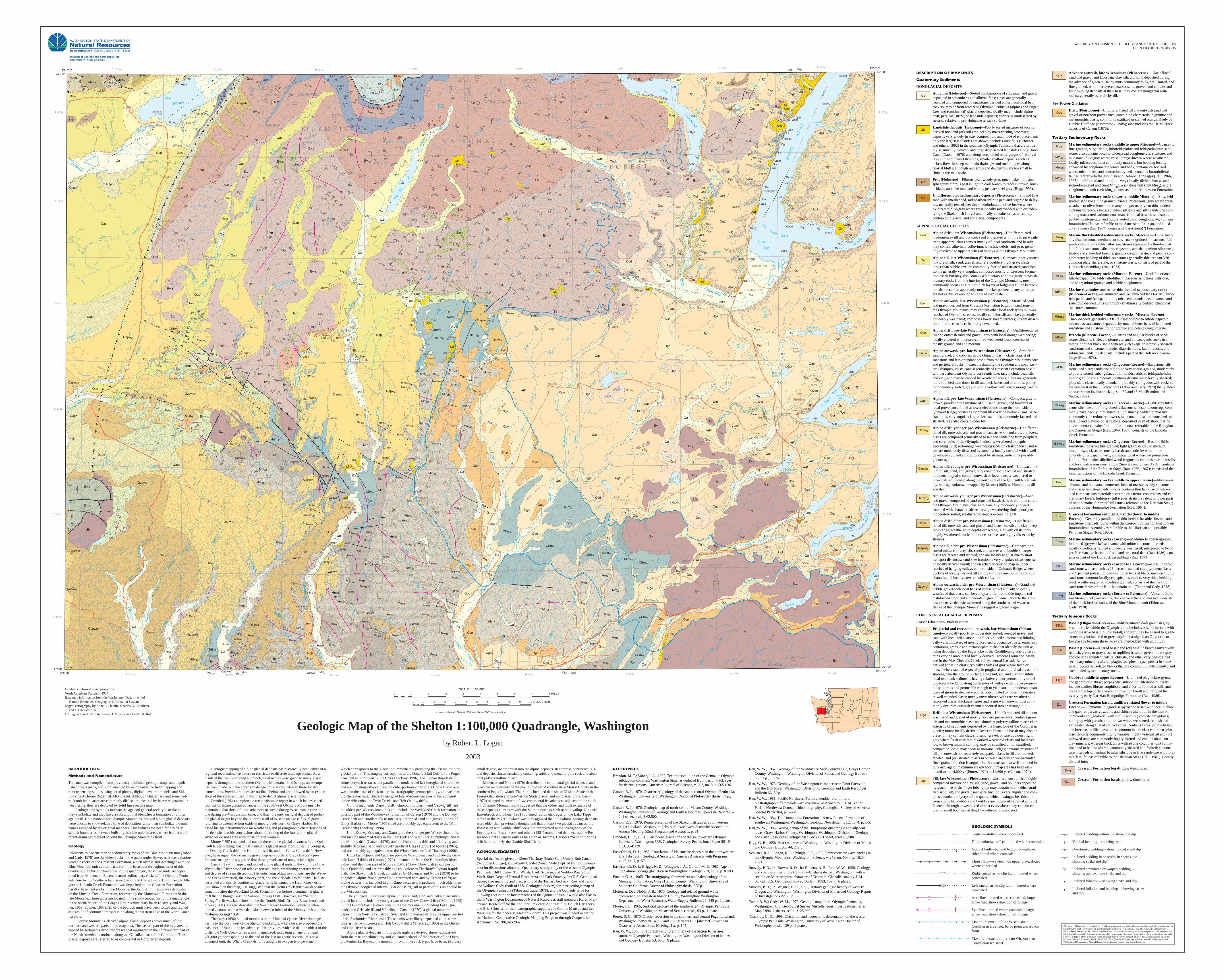
Geologic Map of the Shelton 1:100,000 Quadrangle, Washington
by Robert L. Logan
2003
1 10 KILOMETERS0 1 2 43 5 6 7 8 9
SCALE 1:100 000
1 8 MILES10 2 3 4 5 6 7
WASHINGTON DIVISION OF GEOLOGY AND EARTH RESOURCES
OPEN FILE REPORT 2003-15
Lambert conformal conic projection
North American Datum of 1927
Base map information from the Washington Department of
Natural Resources Geographic Information System
Digital cartography by Anne C. Heinitz, Charles G. Caruthers,
and J. Eric Schuster.
Editing and production by Karen D. Meyers and Jaretta M. Roloff
INTRODUCTION
Methods and Nomenclature
This map was compiled from previously published geologic maps and unpub-
lished thesis maps, and supplemented by reconnaissance field mapping and
remote sensing studies using aerial photos, digital elevation models, and Side-
Looking Airborne Radar (SLAR) images. Although Quaternary and some bed-
rock unit boundaries are commonly diffuse or obscured by heavy vegetation or
weathering, they are depicted by solid lines on this map.
Geologic unit symbols indicate the age and general rock type of the unit
they symbolize and may have a subscript that identifies a formation or a finer
age break. Unit symbols for Olympic Mountains–derived alpine glacial deposits
were chosen to show relative time of deposition rather than symbolize the unit
names assigned by the original mappers. This reduces the need for arbitrary
scratch boundaries between indistinguishable units in areas where ice from dif-
ferent drainages merged beyond the Olympic Mountains front.
Geology
Paleocene to Eocene marine sedimentary rocks of the Blue Mountain unit (Tabor
and Cady, 1978) are the oldest rocks in the quadrangle. However, Eocene marine
volcanic rocks of the Crescent Formation, which overlie and interfinger with the
Blue Mountain unit at their base, form the basement throughout most of this
quadrangle. In the northwest part of the quadrangle, these two units are sepa-
rated from Miocene to Eocene marine sedimentary rocks of the Olympic Penin-
sula core by the Southern fault zone (Tabor and Cady, 1978). The Eocene to Oli-
gocene Lincoln Creek Formation was deposited on the Crescent Formation
basaltic basement rocks. In the Miocene, the Astoria Formation was deposited
on the Lincoln Creek Formation, followed by the Montesano Formation in the
late Miocene. These units are located in the south-central part of the quadrangle
in the northern part of the Grays Harbor sedimentary basin (Snavely and Wag-
ner, 1963; Fowler, 1965). All of the bedrock units have been folded and faulted
as a result of continued transpression along the western edge of the North Amer-
ica plate.
Olympic Mountains–derived alpine glacial deposits cover much of the
northern and western parts of the map area. The eastern part of the map area is
capped by sediments deposited by ice that originated in the northwestern part of
the North American continent along the Canadian part of the Cordillera. These
glacial deposits are referred to as continental or Cordilleran deposits.
Geologic mapping of alpine glacial deposits has historically been either of a
regional reconnaissance nature or restricted to discrete drainage basins. As a
result of the basin-mapping approach, local names were given to many glacial
deposits throughout the southern Olympic Mountains. In this map, an attempt
has been made to make approximate age correlations between these locally
named units. Previous studies are outlined below and are followed by an explan-
ation of the approach used in this map to depict alpine glacial units.
Crandell (1964) completed a reconnaissance report in which he described
four major alpine glacial advances in the southwest Olympic Mountains. He
maintained that three of these advances occurred during Wisconsinan time and
one during pre-Wisconsinan time, and that “the only surficial deposit of proba-
ble glacial origin beyond the outermost till of Wisconsin age is fluvial gravel”,
referring to extensive iron-oxide-stained gravels north of Grays Harbor. He
based his age determinations on weathering and physiographic characteristics of
the deposits, but his conclusions about the timing of the four alpine glacial
advances do not agree with those of later workers.
Moore (1965) mapped and named three alpine glacial advances in the Qui-
nault River drainage basin. He named his glacial units, from oldest to youngest,
the Donkey Creek drift, the Humptulips drift, and the Chow Chow drift. How-
ever, he assigned the extensive gravel deposits north of Grays Harbor a pre-
Pleistocene age and suggested that these gravels are of nonglacial origin.
Carson (1970) mapped and named alpine glacial units in the vicinity of the
Wynoochee River based on relative terrace levels, weathering characteristics,
and degree of stream dissection. His units from oldest to youngest are the Wede-
kind Creek formation, the Mobray drift, and the Grisdale I to VI drifts. He also
described a primarily continental glacial drift he named the Helm Creek drift
(not shown on this map). He suggested that the Helm Creek drift was deposited
sometime after the Wedekind Creek Formation but before a continental glacial
drift that he thought was the Salmon Springs Drift. However, his “Salmon
Springs” drift was later shown to be the Double Bluff Drift by Easterbrook and
others (1981). He also described the Weatherwax formation, which he inter-
preted as outwash that was deposited between lobes of the Mobray drift and his
“Salmon Springs” drift.
Thackray (1996) studied moraines in the Hoh and Queets River drainage
basins to the northwest of the Shelton quadrangle, where he also proposed the
existence of four alpine ice advances. He provides evidence that the oldest of the
drifts, the Wolf Creek, is reversely magnetized, indicating an age of at least
780,000 yr, corresponding to the end of the last magnetic reversal. His next
youngest unit, the Whale Creek drift, he assigns to oxygen isotope stage 6,
which corresponds to the glaciation immediately preceding the last major inter-
glacial period. This roughly corresponds to the Double Bluff Drift of the Puget
Lowland at more than 125,000 yr (Thackray, 1996). His Lyman Rapids drift
forms outwash terraces that parallel the modern and last interglacial shorelines
and are indistinguishable from the older portions of Moore’s Chow Chow out-
wash on the basis of rock materials, stratigraphy, geomorphology, and weather-
ing characteristics. Thackray assigned late Wisconsinan ages to his youngest
alpine drift units, the Twin Creeks and Hoh Oxbow drifts.
On this map, units Qapw1 (drift), Qapwo
1 (outwash), and Qapwt
1 (till) are
the oldest pre-Wisconsinan units and include the Wedekind Creek formation and
possibly part of the Weatherwax formation of Carson (1970) and the Donkey
Creek drift and “moderately to intensely deformed sand and gravel” (north of
Grays Harbor) of Moore (1965), and are probably age equivalent to the Wolf
Creek drift (Thackray, 1996).
Units Qapw2, Qapwo
2, and Qapwt
2 are the younger pre-Wisconsinan units
and include unnamed drifts in the East Fork and West Fork Humptulips Rivers,
the Mobray drift (Carson, 1970), and the Humptulips drift and “flat lying and
slightly deformed sand and gravel” (north of Grays Harbor) of Moore (1965),
and are probably age-equivalent to the Whale Creek drift of Thackray (1996).
Units Qap, Qapo, and Qapt are pre–late Wisconsinan and include the Gris-
dale I and II drifts of Carson (1970), unnamed drifts in the Humptulips River
valley, and the older part of Moore’s (1965) Chow Chow drift (southwest of
Lake Quinault), and are probably age equivalent to Thackray’s Lyman Rapids
drift. The Skokomish Gravel, considered by Molenaar and Noble (1970) to be
nonglacial alpine fluvial gravel but interpreted here and by Carson (1979) as
alpine outwash, is included in unit Qapo because it is probably much older than
the Olympia nonglacial interval (Carson, 1979); all or parts of this unit could be
pre-Wisconsinan.
The youngest Pleistocene alpine units are Qad, Qao, and Qat and are inter-
preted here to include the younger part of the Chow Chow drift of Moore (1965)
in the Quinault basin (which constitutes the moraine impounding Lake Qui-
nault), the Grisdale III and VI drifts of Carson (1970), a glacial outburst flood
deposit in the West Fork Satsop River, and an unnamed drift in the upper reaches
of the Skokomish River basin. These units were likely deposited at the same
time as the Twin Creeks and Hoh Oxbow drifts (Thackray, 1996) in the Queets
and Hoh River basins.
Alpine glacial deposits in this quadrangle are derived almost exclusively
from the marine sedimentary and volcanic bedrock of the interior of the Olym-
pic Peninsula. Beyond the mountain front, other rock types have been, to a very
small degree, incorporated into the alpine deposits. In contrast, continental gla-
cial deposits characteristically contain granitic and metamorphic rock and abun-
dant polycrystalline quartz.
Molenaar and Noble (1970) described the continental glacial deposits and
provided an overview of the glacial history of southeastern Mason County in the
southern Puget Lowland. Their units included deposits of Vashon Stade of the
Fraser Glaciation and pre–Vashon Stade glacial and nonglacial units. Carson
(1970) mapped the extent of two continental ice advances adjacent to the south-
ern Olympic Mountains and suggested that the oldest and most extensive of
these deposits correlates with the Salmon Springs Drift near Puyallup. Not until
Easterbrook and others (1981) obtained radiometric ages on the Lake Tapps
tephra in the Puget Lowland was it recognized that the Salmon Springs deposits
were older than previously thought and that at least two glacial advances, the
Possession and Double Bluff, were not represented in the stratigraphy of the
Puyallup site. Easterbrook and others (1981) maintained that because the Pos-
session Drift advanced only as far south as Tacoma, Carson’s “Salmon Springs”
drift is more likely the Double Bluff Drift.
ACKNOWLEDGMENTS
Special thanks are given to Glenn Thackray (Idaho State Univ.), Bob Carson
(Whitman College), and Wendy Gerstel (Wash. State Dept. of Natural Resour-
ces) for discussions about the Quaternary stratigraphy of the western Olympic
Peninsula; Bill Lingley, Tim Walsh, Hank Schasse, and Weldon Rau (all of
Wash. State Dept. of Natural Resources) and Park Snavely, Jr. (U.S. Geological
Survey) for mapping and discussions of the Tertiary bedrock; Rowland Tabor
and Wallace Cady (both of U.S. Geological Survey) for their geologic map of
the Olympic Peninsula (Tabor and Cady, 1978); and the Quinault Tribe for
allowing access to the lower reaches of the Quinault basin. I would also like to
thank Washington Department of Natural Resources staff members Karen Mey-
ers and Jari Roloff for their editorial reviews; Anne Heinitz, Chuck Caruthers,
and Eric Schuster for their cartographic support; and Connie Manson and Lee
Walkling for their library research support. This project was funded in part by
the National Cooperative Geologic Mapping Program through Cooperative
Agreement No. 98QAG2062.
REFERENCES
Brandon, M. T.; Vance, J. A., 1992, Tectonic evolution of the Cenozoic Olympic
subduction complex, Washington State, as deduced from fission track ages
for detrital zircons: American Journal of Science, v. 292, no. 8, p. 565-636.
Carson, R. J., 1970, Quaternary geology of the south-central Olympic Peninsula,
Washington: University of Washington Doctor of Philosophy thesis, 67 p.,
4 plates.
Carson, R. J., 1976, Geologic map of north-central Mason County, Washington:
Washington Division of Geology and Earth Resources Open File Report 76-
2, 1 sheet, scale 1:62,500.
Carson, R. J., 1979, Reinterpretation of the Skokomish gravel, southwestern
Puget Lowland, Washington [abstract]: Northwest Scientific Association,
Annual Meeting, 52nd, Program and Abstracts, p. 31.
Crandell, D. R., 1964, Pleistocene glaciations of the southwestern Olympic
Peninsula, Washington: U.S. Geological Survey Professional Paper 501-B,
p. B135-B139.
Easterbrook, D. J., 1985, Correlation of Pleistocene deposits in the northwestern
U.S. [abstract]: Geological Society of America Abstracts with Programs,
v. 17, no. 7, p. 571.
Easterbrook, D. J.; Briggs, N. D.; Westgate, J. A.; Gorton, M. P., 1981, Age of
the Salmon Springs glaciation in Washington: Geology, v. 9, no. 2, p. 87-93.
Fowler, G. A., 1965, The stratigraphy, foraminifera and paleoecology of the
Montesano Formation, Grays Harbor County, Washington: University of
Southern California Doctor of Philosophy thesis, 355 p.
Molenaar, Dee; Noble, J. B., 1970, Geology and related ground-water
occurrence, southeastern Mason County, Washington: Washington
Department of Water Resources Water-Supply Bulletin 29, 145 p., 2 plates.
Moore, J. L., 1965, Surficial geology of the southwestern Olympic Peninsula:
University of Washington Master of Science thesis, 63 p., 1 plate.
Porter, S. C., 1970, Glacier recession in the southern and central Puget Lowland,
Washington, between 14,000 and 13,000 years B.P. [abstract]: American
Quaternary Association, Meeting, 1st, p. 107.
Rau, W. W., 1966, Stratigraphy and foraminifera of the Satsop River area,
southern Olympic Peninsula, Washington: Washington Division of Mines
and Geology Bulletin 53, 66 p., 8 plates.
Rau, W. W., 1967, Geology of the Wynoochee Valley quadrangle, Grays Harbor
County, Washington: Washington Division of Mines and Geology Bulletin
56, 51 p., 1 plate.
Rau, W. W., 1973, Geology of the Washington coast between Point Grenville
and the Hoh River: Washington Division of Geology and Earth Resources
Bulletin 66, 58 p.
Rau, W. W., 1981, Pacific Northwest Tertiary benthic foraminiferal
biostratigraphic framework—An overview. In Armentrout, J. M., editor,
Pacific Northwest Cenozoic biostratigraphy: Geological Society of America
Special Paper 184, p. 67-84.
Rau, W. W., 1984, The Humptulips Formation—A new Eocene formation of
southwest Washington: Washington Geologic Newsletter, v. 12, no. 4, p. 1-5.
Rau, W. W., 1986, Geologic map of the Humptulips quadrangle and adjacent
areas, Grays Harbor County, Washington: Washington Division of Geology
and Earth Resources Geologic Map GM-33, 1 sheet, scale 62,500.
Rigg, G. B., 1958, Peat resources of Washington: Washington Division of Mines
and Geology Bulletin 44, 272 p.
Schuster, R. L.; Logan, R. L.; Pringle, P. T., 1992, Prehistoric rock avalanches in
the Olympic Mountains, Washington: Science, v. 258, no. 5088, p. 1620-
1621.
Snavely, P. D., Jr.; Brown, R. D., Jr.; Roberts, A. E.; Rau, W. W., 1958, Geology
and coal resources of the Centralia–Chehalis district, Washington, with a
section on Microscopical character of Centralia–Chehalis coal, by J. M.
Schopf: U.S. Geological Survey Bulletin 1053, 159 p., 6 plates.
Snavely, P. D., Jr.; Wagner, H. C., 1963, Tertiary geologic history of western
Oregon and Washington: Washington Division of Mines and Geology Report
of Investigations 22, 25 p.
Tabor, R. W.; Cady, W. M., 1978, Geologic map of the Olympic Peninsula,
Washington: U.S. Geological Survey Miscellaneous Investigations Series
Map I-994, 2 sheets, scale 1:125,000.
Thackray, G. D., 1996, Glaciation and neotectonic deformation on the western
Olympic Peninsula, Washington: University of Washington Doctor of
Philosophy thesis, 139 p., 2 plates.
DESCRIPTION OF MAP UNITS
Quaternary Sediments
NONGLACIAL DEPOSITS
Qa Alluvium (Holocene)—Sorted combinations of silt, sand, and gravel
deposited in streambeds and alluvial fans; clasts are generally
rounded and composed of sandstone, derived either from local bed-
rock sources or from reworked Olympic Peninsula (alpine) and Puget
Lowland (continental) glacial deposits; locally may include alpine
drift, peat, lacustrine, or landslide deposits; surface is undissected by
streams relative to pre-Holocene terrace surfaces.
Qls Landslide deposits (Holocene)—Poorly sorted mixtures of locally
derived rock and (or) soil emplaced by mass-wasting processes;
deposits vary widely in size, composition, and mode of emplacement;
only the largest landslides are shown; includes rock falls (Schuster
and others, 1992) in the southeast Olympic Peninsula that are proba-
bly seismically induced, and large deep-seated landslides along Hood
Canal (Carson, 1976) and along steep-sided inner gorges of river val-
leys in the southern Olympics; smaller shallow deposits such as
debris flows in steep mountain drainages and rock topples along
coastal bluffs, although numerous and dangerous, are too small to
show at the map scale.
Qp Peat (Holocene)—Fibrous peat, woody peat, muck, lake mud, and
sphagnum; fibrous peat is light to dark brown to reddish brown, muck
is black, and lake mud and woody peat are steel gray (Rigg, 1958).
Qc Undifferentiated sedimentary deposits (Pleistocene)—Silt and fine
sand with interbedded, radiocarbon-infinite peat and organic hash lay-
ers; generally tens of feet thick; nonindurated; olive-brown where
oxidized to blue-gray where fresh; locally interbedded with or under-
lying the Skokomish Gravel and locally contains dropstones; may
contain both glacial and nonglacial components.
ALPINE GLACIAL DEPOSITS
Qad Alpine drift, late Wisconsinan (Pleistocene)—Undifferentiated
medium-gray till and outwash sand and gravel with little to no weath-
ering apparent; clasts consist mostly of local sandstone and basalt;
may contain alluvium, colluvium, landslide debris, and peat; gener-
ally restricted to upper reaches of valleys in the Olympic Mountains.
Qat Alpine till, late Wisconsinan (Pleistocene)—Compact, poorly sorted
mixture of silt, sand, gravel, and rare boulders; light gray; clasts
larger than pebble size are commonly faceted and striated; sand frac-
tion is generally very angular; composed mostly of Crescent Forma-
tion basalt but may also contain sedimentary and low-grade metasedi-
mentary rocks from the interior of the Olympic Mountains; most
commonly occurs as 1 to 2 ft thick layers of lodgment till on bedrock,
but also occurs in apparently much thicker pockets; many outcrops
are not extensive enough to show at map scale.
Qao Alpine outwash, late Wisconsinan (Pleistocene)—Stratified sand
and gravel derived from Crescent Formation basalt or sandstone of
the Olympic Mountains; may contain other local rock types in lower
reaches of Olympic streams; locally contains silt and clay; generally
not deeply weathered; composes lower stream terraces; stream dissec-
tion of terrace surfaces is poorly developed.
Qap Alpine drift, pre–late Wisconsinan (Pleistocene)—Undifferentiated
till and outwash sand and gravel; gray with local orange weathering;
locally covered with cream-colored weathered loess; consists of
mostly ground and end moraine.
Qapo Alpine outwash, pre–late Wisconsinan (Pleistocene)—Stratified
sand, gravel, and cobbles; in the Quinault basin, clasts consist of
sandstone and less-abundant basalt from the Olympic Mountains core
and peripheral rocks; in streams draining the southern and southeast-
ern Olympics, clasts consist primarily of Crescent Formation basalt
with less-abundant Olympic-core sandstone; may include peat, silt,
and clay, and may be capped by weathered loess; clasts are generally
more rounded than those in till and lack facets and striations; poorly
to moderately sorted; gray to subtle yellow with wispy orange weath-
ering.
Qapt Alpine till, pre–late Wisconsinan (Pleistocene)—Compact, gray to
brown, poorly sorted mixture of silt, sand, gravel, and boulders of
local provenance found at lower elevations along the north side of
Quinault Ridge; occurs as lodgment till covering bedrock; small-size
fraction is very angular; larger-size fraction is commonly faceted and
striated; may also contain older till.
Qapw2 Alpine drift, younger pre-Wisconsinan (Pleistocene)—Undifferen -
tiated till, outwash sand and gravel, lacustrine silt and clay, and loess;
clasts are composed primarily of basalt and sandstone from peripheral
and core rocks of the Olympic Peninsula; weathered to depths
exceeding 12 ft; red-orange weathering rinds on clasts; ancient surfa-
ces are moderately dissected by streams; locally covered with a well-
developed soil and strongly incised by streams, indicating possibly
greater age.
Qapwt2 Alpine till, younger pre-Wisconsinan (Pleistocene)—Compact mix-
ture of silt, sand, and gravel; may contain some faceted and striated
boulders; may also contain outwash or loess; deeply weathered to
brownish red; located along the north side of the Quinault River val-
ley; true age unknown; mapped by Moore (1965) as Humptulips till
and drift.
Qapwo2 Alpine outwash, younger pre-Wisconsinan (Pleistocene)—Sand
and gravel composed of sandstone and basalt derived from the core of
the Olympic Mountains; clasts are generally moderately to well
rounded with characteristic red-orange weathering rinds; poorly to
moderately sorted; weathered to depths exceeding 12 ft.
Qapw1 Alpine drift, older pre-Wisconsinan (Pleistocene)—Undifferen -
tiated till, outwash sand and gravel, and lacustrine silt and clay; deep
red-orange; weathered to depths exceeding 60 ft with clasts thor-
oughly weathered; ancient moraine surfaces are highly dissected by
streams.
Qapwt1 Alpine till, older pre-Wisconsinan (Pleistocene)—Compact, non-
sorted mixture of clay, silt, sand, and gravel with boulders; larger
clasts are faceted and striated, and are locally angular due to short
transport distances; sand-size fraction is very angular; clasts consist
of locally derived basalt; shown schematically on map in upper
reaches of hanging valleys on north side of Quinault Ridge, where
pockets of locally derived till are present in ravine bottoms and side
channels and locally covered with colluvium.
Qapwo1 Alpine outwash, older pre-Wisconsinan (Pleistocene)—Sand and
pebble gravel with local beds of coarse gravel and silt; so deeply
weathered that clasts can be cut by a knife; iron oxide imparts red-
dish-brown color and a moderate degree of cementation to the grav-
els; extensive deposits scattered along the southern and western
flanks of the Olympic Mountains suggest a glacial origin.
CONTINENTAL GLACIAL DEPOSITS
Fraser Glaciation, Vashon Stade
Qgo Proglacial and recessional outwash, late Wisconsinan (Pleisto-
cene)—Typically poorly to moderately sorted, rounded gravel and
sand with localized coarser- and finer-grained constituents; lithologi-
cally varied mixture of mostly northern-provenance clasts, especially
containing granitic and metamorphic rocks that identify the unit as
being deposited by the Puget lobe of the Cordilleran glacier; also con-
tains varying amounts of locally derived Crescent Formation basalt,
and in the Mox Chehalis Creek valley, central Cascade Range–
derived andesitic clasts; typically shades of gray where fresh or
brown where stained especially in proglacial and morainal areas; buff
staining near the ground surface; fine sand, silt, and clay constitute
local overbank sediments having relatively poor permeability or del-
taic foreset bedding along north sides of valleys with higher permea-
bility; porous and permeable enough to yield small to moderate quan-
tities of groundwater; very poorly consolidated to loose; moderately
to well-rounded clasts; mostly unweathered with rare weathered
reworked clasts; thickness varies and is not well known; most com-
monly occupies outwash channels scoured into or through till.
Qgd Drift, late Wisconsinan (Pleistocene)—Undifferentiated till and out-
wash sand and gravel of mostly northern provenance; contains gran-
itic and metamorphic clasts and abundant polycrystalline quartz char-
acteristic of sediments deposited by the Puget lobe of the Cordilleran
glacier; minor locally derived Crescent Formation basalt may also be
present; may contain clay, silt, sand, gravel, or rare boulders; light
gray where fresh with rare reworked weathered clasts and local yel-
low to brown mineral staining; may be stratified or nonstratified;
compact to loose; may occur as morainal ridges; contains mixtures of
till and outwash not separately mappable; clasts in till are rounded,
faceted, and (or) striated; clasts in outwash are sub- to well-rounded;
finer-grained fraction is angular in till versus sub- to well-rounded in
outwash; age of maximum ice advance in map area has been esti-
mated to be 14,000 yr (Porter, 1970) to 12,600 yr (Carson, 1970).
Qgt Till, late Wisconsinan (Pleistocene)—Unsorted, unstratified, highly
compacted mixture of clay, silt, sand, gravel, and boulders deposited
by glacial ice of the Puget lobe; gray; may contain interbedded strati-
fied sand, silt, and gravel; sand-size fraction is very angular and con-
tains abundant polycrystalline quartz, which distinguishes this unit
from alpine till; cobbles and boulders are commonly striated and (or)
faceted; although unweathered almost everywhere, may contain cob-
bles or small boulders of deeply weathered granitic rock.
Qga Advance outwash, late Wisconsinan (Pleistocene)—Glaciofluvial
sand and gravel and lacustrine clay, silt, and sand deposited during
the advance of glaciers; sandy units commonly thick, well sorted, and
fine grained, with interlayered coarser sand, gravel, and cobbles and
silt rip-up lag deposits at their base; may contain nonglacial sedi-
ments; generally overlain by till.
Pre–Fraser Glaciation
Qgp Drift, (Pleistocene)—Undifferentiated till and outwash sand and
gravel of northern provenance, containing characteristic granitic and
metamorphic clasts; commonly oxidized or stained orange; likely of
Double Bluff age (Easterbrook, 1985); also includes the Helm Creek
deposits of Carson (1970).
Tertiary Sedimentary Rocks
Mm2/2s/2t/2c Marine sedimentary rocks (middle to upper Miocene)—Coarse- to
fine-grained, silty, friable, lithofeldspathic and feldspatholithic sand-
stone; also contains local to widespread conglomerate, siltstone, and
mudstone; blue-gray where fresh, orange-brown where weathered;
locally tuffaceous; most commonly massive, but bedding locally
enhanced by conglomerate lenses and beds; contains carbonized
wood, mica flakes, and concretionary beds; contains foraminiferal
faunas referable to the Mohnian and Delmontian Stages (Rau, 1966,
1967); undifferentiated unit (unit Mm2) locally divided into a sand-
stone-dominated unit (unit Mm2s
), a siltstone unit (unit Mm2t
), and a
conglomerate unit (unit Mm2c
); consists of the Montesano Formation.
Mm1 Marine sedimentary rocks (lower to middle Miocene)—Silty, feld-
spathic sandstone; fine grained; friable; micaceous; gray where fresh,
weathers to olive-brown or creamy orange; massive to thin bedded;
contains tuffaceous beds; abundant siltstone and silty sandstone con-
taining macerated carbonaceous material; local basaltic sandstone,
pebble conglomerate, and poorly sorted basal conglomerate; contains
foraminiferal faunas referable to the Saucesian, Relizian, and Luisi-
an(?) Stages (Rau, 1967); consists of the Astoria(?) Formation.
Mmst Marine thick-bedded sedimentary rocks (Miocene)—Thick, later-
ally discontinuous, medium- to very coarse-grained, micaceous, feld-
spatholithic to lithofeldspathic sandstones separated by thin-bedded
(1–12 in.) sandstone, siltstone, claystone, and shale; minor siltstone-,
shale-, and slate-clast breccia, granule conglomerate, and pebble con-
glomerate; bedding of thick sandstones generally thicker than 3 ft;
common platy shale, slate, or siltstone clasts; consists of part of the
Hoh rock assemblage (Rau, 1973).
MEm Marine sedimentary rocks (Miocene–Eocene)—Undifferentiated
lithofeldspathic to feldspatholithic micaceous sandstone, siltstone,
and slate; minor granule and pebble conglomerate.
MEmr Marine rhythmites and other thin-bedded sedimentary rocks
(Miocene–Eocene)—Laminated and (or) thin-bedded (1–8 in.), litho-
feldspathic and feldspatholithic, micaceous sandstone, siltstone, and
slate; thin-bedded units commonly rhythmically bedded; phacoidal
structures common.
MEmst Marine thick-bedded sedimentary rocks (Miocene–Eocene)—
Thick-bedded (generally >3 ft) feldspatholithic to lithofeldspathic
micaceous sandstones separated by much thinner beds of laminated
sandstone and siltstone; minor granule and pebble conglomerate.
MEbx Breccia (Miocene–Eocene)—Lenses and angular blocks of sand-
stone, siltstone, shale, conglomerate, and volcanogenic rocks in a
matrix of either black shale with scaly cleavage or intensely sheared
sandstone and siltstone; includes diapiric muds, fault breccias, and
submarine landslide deposits; includes part of the Hoh rock assem-
blage (Rau, 1973).
OEm Marine sedimentary rocks (Oligocene–Eocene)—Sandstone, silt-
stone, and slate; sandstone is fine- to very coarse-grained, moderately
to poorly sorted, subangular, and lithofeldspathic or feldspatholithic;
minor granule conglomerate; contains detrital mica; locally sheared;
platy slate clasts locally abundant; probably contiguous with rocks to
the northeast in the Olympic core (Tabor and Cady, 1978) that yielded
unreset zircon fission-track ages of 32 and 48 Ma (Brandon and
Vance, 1992).
OEmlc Marine sedimentary rocks (Oligocene–Eocene)—Light-gray tuffa-
ceous siltstone and fine-grained tuffaceous sandstone; outcrops com-
monly have hackly joint structure; indistinctly bedded to massive,
commonly concretionary; lower strata contain discontinuous beds of
basaltic and glauconitic sandstone; deposited in an offshore marine
environment; contains foraminiferal faunas referable to the Refugian
and Zemorrian Stages (Rau, 1966, 1967); consists of the Lincoln
Creek Formation.
OEmlcs Marine sedimentary rocks (Oligocene–Eocene)—Basaltic lithic
sandstone; massive; fine grained; light greenish gray to medium
olive-brown; clasts are mostly basalt and andesite with minor
amounts of feldspar, quartz, and mica; local water-laid pumiceous
lapilli tuff; contains silicified wood fragments; contains marine fossils
and local calcareous concretions (Snavely and others, 1958); contains
foraminifera of the Refugian Stage (Rau, 1966, 1967); consists of the
basal sandstone of the Lincoln Creek Formation.
Em2 Marine sedimentary rocks (middle to upper Eocene)—Micaceous
siltstone and mudstone, numerous beds of massive sandy siltstone,
and sparse sandstone beds; locally contains thin lamellae of macer-
ated carbonaceous material; scattered calcareous concretions and con-
cretionary layers; light-gray tuffaceous strata prevalent in lower parts
of unit; contains foraminiferal faunas referable to the Narizian Stage;
consists of the Humptulips Formation (Rau, 1984).
Em1c Crescent Formation sedimentary rocks (lower to middle
Eocene)—Generally parallel- and thin-bedded basaltic siltstone and
sandstone interbeds found within the Crescent Formation that contain
foraminiferal assemblages referable to the Ulatisian and possibly
Penutian Stages (Rau, 1986).
Em1h Marine sedimentary rocks (Eocene)—Medium- to coarse-grained,
indurated ‘greywacke’ sandstone with minor siltstone interbeds;
mostly chaotically faulted and deeply weathered; interpreted to be of
pre-Narizian age based on fossil and structural data (Rau, 1986); con-
sists of part of the Hoh rock assemblage (Rau, 1973).
EPAm Marine sedimentary rocks (Eocene to Paleocene)—Basaltic lithic
sandstone with as much as 15 percent rounded clinopyroxene clasts
and 5 percent potassium feldspar; thick beds of black, mica-rich lithic
sandstone common locally; conspicuous thick to very thick bedding;
black weathering to red; medium grained; consists of the basaltic
sandstone facies of the Blue Mountain unit (Tabor and Cady, 1978).
EPAml Marine sedimentary rocks (Eocene to Paleocene)—Volcanic lithic
sandstone; black; micaceous; thick to very thick to massive; consists
of the thick-bedded facies of the Blue Mountain unit (Tabor and
Cady, 1978).
Tertiary Igneous Rocks
OEvb Basalt (Oligocene–Eocene)—Undifferentiated dark greenish gray
basaltic rocks within the Olympic core; includes basaltic breccia with
minor massive basalt, pillow basalt, and tuff; may be altered to green-
stone; may include red or green argillite; assigned an Oligocene to
Eocene age because these rocks are interbedded with unit OEm.
Evb Basalt (Eocene)—Altered basalt and (or) basaltic breccia mixed with
reddish, green, or gray clasts of argillite; basalt is green or dark gray
and contains abundant calcite, chlorite, and other very fine-grained
secondary minerals; altered plagioclase phenocrysts persist in some
basalt; occurs as isolated blocks that are commonly fault-bounded and
surrounded by sedimentary rocks.
Eigb Gabbro (middle to upper Eocene)—Uralitized plagioclase-pyrox-
ene gabbro or diabase; porphyritic; subophitic; alteration minerals
include zeolite, fibrous amphibole, and chlorite; formed as sills and
dikes at the top of the Crescent Formation basalt and intruded the
overlying early Narizian Humptulips Formation (Rau, 1986).
Evc Crescent Formation basalt, undifferentiated (lower to middle
Eocene)—Submarine, plagioclase-pyroxene basalt with local diabase
and gabbro; pervasive zeolite and chlorite alteration in the matrix;
commonly amygdaloidal with zeolite and (or) chlorite amygdules;
dark gray with greenish tint, brown where weathered, reddish and
variegated along altered contact zones; contains flows, pillow basalt,
and breccias; refilled lava tubes common in breccias; columnar joint
orientation is commonly highly variable; highly vesiculated and (or)
pillowed units are commonly highly altered and contain abundant
clay minerals, whereas thick units with strong columnar joint forma-
tion tend to be less altered; commonly sheared and faulted; contains
rare interbeds of laminar basaltic siltstone or fine sandstone with fora-
miniferal faunas referable to the Ulatisian Stage (Rau, 1981). Locally
divided into:
Evcf Crescent Formation basalt, flow dominated
Evcp Crescent Formation basalt, pillow dominated
Disclaimer: This product is provided ‘as is’ without warranty of any kind, either expressed or implied, including, but not
limited to, the implied warranties of merchantability and fitness for a particular use. The Washington Department of
Natural Resources will not be liable to the user of this product for any activity involving the product with respect to the
following: (a) lost profits, lost savings, or any other consequential damages; (b) the fitness of the product for a particular
purpose; or (c) use of the product or results obtained from use of the product. This product is considered to be exempt
from the Geologist Licensing Act [RCW 18.220.190 (4)] because it is geological research conducted by the State of
Washington, Department of Natural Resources, Division of Geology and Earth Resources.
GEOLOGIC SYMBOLS
Contact—dotted where concealed
Fault, unknown offset—dotted where concealed
Normal fault—bar and ball on downthrown
side; dotted where concealed
Thrust fault—sawteeth on upper plate; dotted
where concealed
Right-lateral strike-slip fault—dotted where
concealed
Left-lateral strike-slip fault—dotted where
concealed
Anticline—dotted where concealed; large
arrowhead shows direction of plunge
Syncline—dotted where concealed; large
arrowhead shows direction of plunge
Maximum extent of late Wisconsinan
Cordilleran ice sheet; barbs point toward ice
front
Maximum extent of pre–late Wisconsinan
Cordilleran Ice sheet
Inclined bedding—showing strike and dip
Vertical bedding—showing strike
Overturned bedding—showing strike and dip
Inclined bedding in phacoids in shear zone—
showing strike and dip
Inclined crenulated or warped bedding—
showing approximate strike and dip
Inclined foliation—showing strike and dip
Inclined foliation and bedding—showing strike
and dip
Qp
Qls
Qgt
Qgp
Qgo
Qgd
Qga
Qc
Qat
Qapwt2
Qapwt1
Qapwo2
Qapwo1
Qapw2
Qapw1
Qapt
Qapo
Qap
Qao
Qad
Qa
…Evb
…Emlcs
…Emlc
…Em
„mst
„m2t
„m2s
„m2c
„m2
„m1
„Emst
„Emr
„Em
„Ebx
Evb
Evcp
Evcf
Evc
Em2
Em1h
Em1c
Eigb
E†ml
E†m
contour interval 100 feet (500 feet above 500 feet elevation)
T. 18 N.
T. 19 N.
T. 20 N.
T. 21 N.
T. 22 N.
T. 23 N.
T. 18 N.
T. 19 N.
T. 20 N.
T. 21 N.
T. 22 N.
T. 23 N.
R. 3 W.R. 4 W.R. 5 W.R. 6 W.R. 7 W.R. 8 W.R. 9 W.R. 10 W.
R. 3 W.R. 4 W.R. 5 W.R. 6 W.R. 7 W.R. 8 W.R. 9 W.R. 10 W.
47°00¢
123°00¢
47°30¢
123°00¢
47°30¢
124°00¢
47°00¢
124°00¢
SOUTHERN FAULTZO
NE
R i v e rR i v e r
PU
GE
T
LO
WL
AN
D
OLYMPIC
MOUNTAINS
Qa
OLYMPIC NATIONAL PARK E†m
E†ml
E†ml
E†ml
E†ml
E†m
E†m
Eigb
Eigb
Eigb
Eigb
Em1c
Em1c
Em1c
Em1c
Em1c
Em1c
Em1c
Em1c
Em1c
Em1c
Em1c
Em1c
Em1c
Em1c Em1c
Em1c
Em1c
Em1c
Em1c
Em1c
Em1c
Em1c
Em1c
Em1c
Em2
Em2 Em2Em2
Em2
Em2
Em2
Em2
Em2
Em2
Em2
Em2
Em2
Em2
Em2
Em2Em2
Em2
Em2
Em2 Em2
Evc
Evc
Evc
Evc
Evc
Evc
Evc
Evc
Evc
Evc
Evc
Evc
Evc
Evc
Evc
Evc
Evc
Evc
Evc
Evc
Evc
Evc
Evc
Evc
Evc
Evc
Evc
Evc
Evc
Evc
Evc
EvcEvc
Evc
EvcEvc
Evcf
Evcf
Evcf
Evcf
Evcf
Evcf
Evcf
Evcf
Evcf
EvcfEvcf
Evcf
Evcf Evcf
Evcf
Evcf Evcf
Evcf
Evcf
Evcf
Evcf
Evcf
Evcf
Evcf
Evcf
Evcf
Evcf
Evcf
Evcf
Evcf
Evcf
Evcf
Evcf
Evcf
Evcp
Evcp
Evcp
Evcp
Evcp
Evcp
Evcp
Evcp
Evcp
Evcp
Evcp
Evb
Evb
EvbEvb
„Ebx„Ebx
„Em
„Emr
„Emr
„Emst
„m1
„m1
„m1
„m1
„m1
„m1
„m1
„m1
„m1
„m1
„m1
„m1
„m1
„m1
„m2
„m2
„m2
„m2
„m1
„m2
„m2
„m2
„m2
„m2
„m2c
„m2c
„m2c
„m2c
„m2c „m2c
„m2s
„m2c
„m2c
„m2c
„m2c
„m2c
„m2c
„m2s
„m2s
„m2s
„m2s
„m2s
„m2s„m2s
„m2s
„m2s
„m2s
„m2s
„m2s
„m2s
„m2s
„m2s
„m2s
„m2s
„m2s „m2s
„m2s
„m2s
„m2t
„m1
„m2s
„m2s
„m2s
„m2s
„m2t
„m2s
„m2s
„m2s
„m2s
„m2s
„m2t
„m2t
„m2t
„m2s
„m2c
„m2c
„m2c
„m2s
„m2s
„m2s
„m2t
„m2t
„m2t
„m2t
„m2t
„m2t
„m2t
„m2t
„m2t
„m2t
„m2t
„m2t
„m2t
„m2t
„m2t
„m2t
„m2t
„m2t
„m2t
„m2t
„m2t
„mst
…Em…Em
…Em
…Em
…Emlc
…Emlc
…Emlc
…Emlc
…Emlc
…Emlc
…Emlc…Emlc
…Emlc
…Emlc
…Emlc…Emlc
…Emlc
…Emlc
…Emlc
…Emlc
…Emlc
…Emlc
…Emlc
…Emlc
…Emlc
…Emlc
…Emlc
…Emlc
…Emlc
…Emlc…Emlc
…Emlc
…Emlc
…Emlc
…Emlcs
…Evb
Qa
Qa
Qa
Qa
Qa
Qa
Qa
Qa
Qa
Qa
Qa
Qa
Qa
Qa
Qa
Qa
Qa
Qa
Qa
Qa
Qa
Qa
Qa
Qa
Qa
Qa
QaQa
Qa
Qa
Qa
Qa
Qa
Qa
Qa
Qa
Qa
Qa
Qa
Qa
Qa
Qa
Qa
Qa
Qa
Qa
Qa
Qa
Qa
Qa
Qa
Qa
Qa
Qa
Qa
Qa
Qa
Qa
Qa
Qa
Qa
Qa
Qa
Qa
Qa
Qa
Qa
QaQa
Qa
Qa
Qa
Qa
Qa
Qa
Qa
Qa
Qa
Qa
Qa
Qa
Qa
Qad
Qad
Qad
Qad
Qad
Qad
Qad
Qad
Qad
Qao
Qao
Qao
Qao
Qao
Qao
Qap
Qap
Qap
Qap
Qap
Qap
Qap
Qap
Qap
Qap
Qap
Qap
Qap Qap
Qap
Qap
QapQap
Qap
Qap
QapoQapo
Qapo
Qapo
Qapo
Qapo
Qapo
Qapo
Qapo
Qapo
Qapo
Qapo
Qapo
Qapo
Qapo
Qapo
QapoQapoQapo
Qapo
Qapo
Qapo
Qapo
Qapo
Qapo
Qapo
Qapo
Qapo
Qapo
Qapo
Qapo
Qapo
Qapt
Qapt
Qapt
Qapw2Qapw2
Qapw2
Qapw2
Qapw2
Qapw2
Qapwo1
Qapwo1
Qapwo1
Qapwo1
Qapwo1
Qapwo1
Qapwo1
Qapwo1
Qapwo1
Qapwo1
Qapwo1
Qapwo1
Qapwo1
Qapwo1
Qapwo1
Qapwo1
Qapwo1
Qapwo2
Qapwo2
Qapwo2
Qapwo2
Qapwo2
Qapwo2
Qapwo2
Qapwo2
Qapwo2
Qapwo2
Qapwo2
Qapwo2
Qapwo2
Qapwo2
Qapwo2
Qapwo2
Qapwo2
Qapwo2
Qapwo2
Qapwo2
Qapwo2
Qap
Qap
Qapwt1
Qapwt2
Qat
Qc
Qc
Qc
Qga
Qga
Qga
Qga
Qga
Qga
Qga
Qga
Qga
Qga
Qga
Qga
Qga
Qga
Qga
Qga
Qgo
Qga
Qga
Qga
Qga
Qga
Qga
Qga
QgaQga
Qga
Qga
Qga
Qga
Qga
Qapw1
Qapw1
Qapw1
Qapw1
Qapw1
Qapw1
Qapw1
Qapw1
Qapw1
Qapw1
Qapw1
Qapw1
Qapw1
Qapw1
Qapw1
Qga
Qgd
Qgd
Qgd
Qgd
Qgd
Qgd
Qgd
Qgd
Qgd
Qgd
QgdQgd
Qgo
Qgo
Qgo
Qgo
Qgo
Qgo
Qgo
Qgo
Qgo
Qgo
Qgo
Qgo
Qgo
Qgo
Qgo
Qgo
Qgo
Qgo
Qgo
Qgo
Qgo
Qgo
Qgo
Qgo
Qgo
Qgo
Qgo
Qgo
Qgo
Qgo
Qgo
Qgo
Qgo
Qgo
Qgo
Qgo
Qgo
Qgo
Qgo
Qgo
Qgo
Qgo
Qgo
Qgo
Qgo
Qgo
Qgo
Qgo
Qgo
Qgo
Qgo
Qgo
Qgo
Qgo
Qgo
Qgo
Qgo
Qgo
Qgo
Qgo
Qgo
Qgo
Qgo
Qgo
Qgo
Qgo
Qgp
Qgp
Qgp
Qgp
Qgp
Qgp
Qgp
Qgp
Qgp
Qgp
Qgp
Qgp
Qgp
Qgp
Qgp
Qgp
Qgp
Qgp Qgp
QgpQgp
Qgp
Qgp
Qgp
Qgp
Qgp
Qgp
Qgp
Qgp
Qgp
Qgp
Qgp
Qgp
Qgp
Qgp
Qgp
Qgp
Qgt
Qgt
Qgt
Qgt
Qgt
Qgt
Qgt
Qgt
Qgt
Qgt
Qgt
Qgt
Qgt
Qgt
Qgt
Qgt
Qgt
Qgt
Qgt
Qgt
Qgt
Qgt
Qgt
Qgt
Qgt
Qgt
Qgt
Qgt
Qgt
Qgt
Qgt
Qgt
Qgt
Qgt
Qgt
Qgt
Qgt
Qgt
Qgt
Qgt
Qgt
Qgt
Qgt
Qgt
Qgt
Qgt
Qgt
Qgt
Qgt
Qgt
Qgt
Qgt
Qls
Qls
Qls
Qls
Qls
Qls
Qls
Qls
Qls
QlsQls
Qls
Qls
Qls
Qls
Qls
QlsQls
Qls
Qls
Qls
Qls
Qls
Qls
Qls
Qls
Qls
Qls
Qls
Qls
Qls
Qls
Qls
Qls
QlsQls
Qls
Qp
Qp
Qp
Qgp
Qa
Qa
QlsQls
Qa
Qa
Qls
Qga
Qap
Qap
Qap
Qap
Qap
Qap
Qap
Qap
Qap
Em1c
Em1cEm1c
Em1h
Em1h
Em1h
Em2
Qgt
Qgt
Qgt
Qgp
„m2t
„m1
„m2t
„m2t
„m2t
„m2t
„m2c
„m2c
„m1
„m1
Qa
„m2s
…Emlc
Evcf
Evcf
Qga
Qga
Qga
Qapwo2
…Evb
…Evb
Qls
…Emlc
Evcf
Qgt
Evc
Qgp