Odzivno pismo na delavnio v elovu Response letter to the ... · Odzivno pismo na delavnio v elovu...
40
Odzivno pismo na delavnico v Celovcu Response letter to the Klagenfurt/Celovec workshop Ljubljana, 2017
Transcript of Odzivno pismo na delavnio v elovu Response letter to the ... · Odzivno pismo na delavnio v elovu...

Odzivno pismo na delavnico v Celovcu
Response letter to the Klagenfurt/Celovec workshop
Ljubljana, 2017

Odzivno pismo na delavnico v Celovcu
Geological Survey of Slovenia, Dimičeva ulica 14, P.O. Box 2552, SI-1000 Ljubljana • www.geo-zs.si
2

Odzivno pismo na delavnico v Celovcu
Geological Survey of Slovenia, Dimičeva ulica 14, P.O. Box 2552, SI-1000 Ljubljana • www.geo-zs.si
4
Avtorji
:
dr. Jure Atanackov, univ.dipl.inž.geol. (Geološki zavod
Slovenije)
dr. Miloš Bavec, univ.dipl.inž.geol. (Geološki zavod
Slovenije)
dr. Bogomir Celarc, univ.dipl.inž.geol. (Geološki zavod
Slovenije)
Mr. K. Michael Cline, P.G. (RIZZO Associates)
dr. M. Logan Cline (RIZZO Associates)
dr. Petra Jamšek Rupnik, univ.dipl.inž.geol. (Geološki zavod
Slovenije)
dr. Richard Quittmeyer (RIZZO Associates)
Odzivno pismo na delavnico v Celovcu
Geological Survey of Slovenia, Dimičeva ulica 14, P.O. Box 2552, SI-1000 Ljubljana • www.geo-zs.si
5
Vsebina / Table of Contents
INTRODUCTION ............................................................................................................................... 7
UVOD .............................................................................................................................................. 8
RESPONSE TO REP-0612 ................................................................................................................... 9
SUMMARY ...................................................................................................................................... 9
1. BACKGROUND AND WORKSHOP OBJECTIVES .......................................................................... 11
2. GEOLOGICAL BACKGROUND ................................................................................................... 14
3. SUMMARY OF WORKSHOP CONTRIBUTIONS .......................................................................... 19
3.1 Marko Vrabec (University of Ljubljana) ............................................................................... 19
3.2 Petra Jamšek Rupnik (Geological Survey of Slovenia GeoSZ) ................................................ 20
3.3 Stephane Baize (IRSN) ......................................................................................................... 21
3.4 Miloš Bavec (Geological Survey of Slovenia GeoZS) .............................................................. 24
3.5 K. Michel Cline, M. Logan Cline (RZZO Assoc.) ...................................................................... 25
3.6 Wolfgang Lenhardt (ZAMG Vienna) ...................................................................................... 28
3.7 Marijan Herak, Davorka Herak, Bruno Tomljenović (University of Zagreb) ............................. 28
3.8 Mladen Živčić (Slovenian Environment Agency) ................................................................... 29
3.9 Esther Hintersberger (University Vienna) ............................................................................. 30
3.10 Vanja Kastelic (INGV Roma)................................................................................................. 31
3.11 Livio Sirovich, Franco Pettenati (Università di Trieste), Giovanni Costa, Peter Suhadolc (Istituto
Nazionale di Oceanografia e di Geofisica Sperimentale, O.G.S) ....................................................... 32
4. CONCLUSIONS ........................................................................................................................ 34
REFERENCES .................................................................................................................................. 38

Odzivno pismo na delavnico v Celovcu
Geological Survey of Slovenia, Dimičeva ulica 14, P.O. Box 2552, SI-1000 Ljubljana • www.geo-zs.si
6
Index
Figure 1: Historical/instrumental seismicity and the locations of Krško and other European NPPs. ....................... 17
Figure 2: Seismic hazard inEurope and the locations of Krško and other European NPPs. ...................................... 18

Odzivno pismo na delavnico v Celovcu
Geological Survey of Slovenia, Dimičeva ulica 14, P.O. Box 2552, SI-1000 Ljubljana • www.geo-zs.si
7
INTRODUCTION
This document is a response to the published report (REP-0612) summarizing the Fact Finding
Workshop on the active Tectonics of the Krško Region, held in Klagenfurt/Celovec on April 7, 2016. The
workshop was organized by the Environment Agency Austria and the Land Kärnten and convened by dr.
Kurt Decker, Universität Wien, Department für Geodynamik und Sedimentologie who is also the author
of the report prepared for the Austrian Federal Ministry of Agriculture, Forestry, Environment and
Water Management, I/6 General Coordination of Nuclear Affairs (BMLFUW-UW. 1.12/0008-I/6/215).
This response is prepared on behalf of GEN Energija d.o.o. (order GEN/2017/319, technical
specifications TS-PA17006, contract GEN/66/2017 or GeoZS 1130-85/2017).
The response is prepared to clarify and correct the record regarding presentations by GeoZS and RIZZO
representatives as well as findings by GeoZS and RIZZO in the past and ongoing projects in the Krško
basin. No response is made to claims or statements that do not concern results by GeoZS and RIZZO. In
cases where a response cites ongoing research, this is clearly stated.
In summarizing the Workshop presentations, report REP 0612 (Section 3) uses a two-part format. For
each presentation made at the Workshop, a brief summary of the contents is provided ( »Outline of
contents«) first. Second, a »Remarks« section provides additional notes and commentary by the
author of the Workshop report, Dr. Kurt Decker. A response is added by GeoZS and RIZZO regarding
author's interpretation of the presentations as summarized in this report. The response is bilingual – in
English (»Response«) and Slovene (»Odziv«).
This response document is structured using the following format:
Introduction (this page): provides the purpose and scope of the document.
Report/Response: for each section of report REP 0612 the text from the report is copied in full
and responses are inserted where applicable. Each response is marked with »RESPONSE«.
References: cited references are listed at the end of the document.
The transcript of the original report REP 0612 by Kurt Decker is using black fonts while all responses and comments by GeoZS-RIZZO are dark blue.

Odzivno pismo na delavnico v Celovcu
Geological Survey of Slovenia, Dimičeva ulica 14, P.O. Box 2552, SI-1000 Ljubljana • www.geo-zs.si
8
UVOD
Ta dokument je odziv na poročilo (REP-0612), ki povzema vsebino delavnice z naslovom "Fact Finding
Workshop on the active Tectonics of the Krško Region" v Celovcu 7. aprila 2016. Delavnico je
organizirala Avstrijska okoljska agencija in Dežela Koroška, poročilo pa je bilo pripravjeno za avstrijsko
Zvezno ministrstvo za kmetijstvo, gozdarstvo, okolje in vodooskrbo (BMLFUW-UW. 1.12/0008-I/6/215).
Delavnico je vodil dr. Kurt Decker, Univerza na Dunaju, Oddelek za geodinamiko in sedimentologijo, ki je
tudi avtor poročila. Ta odziv je pripravljen za podjetje GEN Energija d.o.o. (naročilo št. GEN/2017/319,
tehnične specifikacije TS-PA17006, pogodba GEN/66/2017 oz. GeoZS 1130-85/2017).
V Odzivu pojasnjujemo in popravljamo navedbe v zapisu o predstavitvah predstavnikov GeoZS in RIZZO
na delavnici ter navedbe, ki se dotikajo rezultatov in ugotovitev GeoZS in RIZZO med preteklimi in
potekajočimi projekti v Krški kotlini. Na navedbe, ki se ne dotikajo rezultatov GeoZS in RIZZO se ne
odzivamo. V primerih, ko se pri odzivu opiramo na trenutno potekajoče raziskave, to jasno navajamo.
Pri povzemanju predstavitev na delavnici, je v poročilu REP 0612 (Sekcija 3) uporabljen dvodelni
format. Za vsako predstavitev na delavnici je najprej naveden kratek povzetek ("Outline of contents"),
ki mu sledi sekcija "Remarks" z dodatnimi opombami in komentarji avtorja poročila Kurta Deckerja.
GeoZS in RIZZO dodajamo odziv na avtorjeve povzetke oz. interpretacije predstavitev na delavnici.
Odziv je dvojezičen - v angleškem jeziku ("Response") in slovenskem jezik ("Odziv").
Odzivno pismo ima naslednjo strukturo:
Uvod (ta stran): navaja namen in obseg dokumenta.
Poročilo / odziv: za vsako sekcijo poročila REP 0612 je besedilo kopirano v celoti, odzivi pa so
vstavljeni kjer je potrebno. Vsak odziv je označen z "ODZIV".
Reference: citirana literatura, na koncu dokumenta.
Prepis poročila REP 0612 Kurta Deckerja je v črni barvi, odgovori in komentarji GeoZS-RIZZO pa v temno
modri barvi.
Odzivno pismo na delavnico v Celovcu
Geological Survey of Slovenia, Dimičeva ulica 14, P.O. Box 2552, SI-1000 Ljubljana • www.geo-zs.si
9
Response to REP-0612
SUMMARY
The Environment Agency Austria and the Land Kärnten invited 26 geoscientists from six countries to a
technical workshop on the seismicity and active tectonics of the region around the Slovenian nuclear
power plant (NPP) Krško. The workshop was supported by the Austrian Federal Ministry for
Agriculture, Forestry, Environment and Water Management (BMLFUW). It was held in Klagenfurt on
07. April 2016.
The Austrian concerns about the seismic safety of the NPP root in the assessment of the plant during
the Stress Tests performed on European Nuclear Power Plants in 2012. Based on this assessment the
European Nuclear Safety Regulators Group (ENSREG) suggested in its Stress Tests Country Report for
Slovenia that “The regulator should consider requesting to update the seismic design basis”. Concerns
are aggravated by the discovery of a number of active faults next to the NPP in the time after the Stress
Tests1.
RESPONSE: The possible activity of faults mapped or inferred in the vicinity of nuclear power plant
Krško (JEK) is indeterminate. Geomorphological, geological, geophysical, geochronological, and
paleoseismic investigations are currently being conducted by GEN energija d.o.o. (GEN) to
characterize the faults for assessing possible fault activity and possible fault capability.
ODZIV: Morebitna aktivnost kartiranih in predpostavljenih prelomov v bližini jedrske elektrarne Krško
(JEK) ni dokončno določena. GEN energija d.o.o (GEN) trenutno v Krški kotlini izvaja geomorfološke,
geološke, geofizikalne, geokronološke in paleoseizmološke raziskave, ki so namenjene tudi ugotovitvi
morebitne aktivosti in zmožnosti (capability) prelomov.
The workshop confirmed that Krško is located in a tectonically and seismically active area. It further
confirmed the existence of several active faults close to the NPP. Geological data particularly
highlight the Orlica, Artiče and Libna faults as well as an unnamed thrust fault below the Artiče
flexure as potential sources for earthquakes. The correct assessment of the degree of activity of
these faults is of vital importance for the derivation of reliable seismic hazard values. Although
experts mostly agreed on the existence of these faults, no common opinion existed on their degree
of activity. It appeared that this is mainly due to a lack of paleoseismological data. Many experts
therefore highlighted the importance of acquiring additional data to proof or disproof the activity of
the faults and to establish a reliable dataset of fault geometry, kinematics, and slip rates as input for
seismic hazard assessment.
Odzivno pismo na delavnico v Celovcu
Geological Survey of Slovenia, Dimičeva ulica 14, P.O. Box 2552, SI-1000 Ljubljana • www.geo-zs.si
10
RESPONSE: Ongoing activities in the Krško Basin supported by GEN aim at acquiring such additional
data.
ODZIV: Potekajoče aktivnosti v Krški kotlini, ki jih podpira GEN, so namenje pridobivanju teh podatkov.
The workshop results lead to the suggestion that BMLFUW should follow up the issue and consider to
stress in its communication with Slovenian institutions that:
• seismic safety of the NPP Krško is of key importance;
• a new and broadly accepted seismic hazard assessment should be completed by independent
experts as soon as possible;
• seismic hazard assessment should be based on reliable paleoseismic data;
• the possibility for Austrian and international observers to follow up data collection and seismic
hazard assessment would foster confidence in the reliability of the results;
the seismic design basis of the NPP Krško should be updated as soon as possible.
RESPONSE: RIZZO-GeoZS representatives pointed out during the workshop that GEN has an ongoing
program to collect additional geomorphological, geological, geophysical, geochronological, and
paleoseismic data within the proposed Nuclear Power Plant Krsko 2 (JEK 2) site near region (25-km
radius). The program includes use of these data to assess fault capability and to perform an updated
PSHA. The PSHA is being carried out taking into account guidance from the International Atomic Energy
Agency (IAEA), the United States Nuclear Regulatory Commission (US NRC), and the American National
Standards Institute (ANSI)/American Nuclear Society (ANS), which describe the latest approches for
assessing seismic hazards.
ODZIV: Predstavniki RIZZO-GeoZS so na delavnici predstavili, da GEN izvaja program raziskav za
pridobitev dodatnih geomorfoloških, geoloških, geofizikalnih, geokronoloških in paleoseizmoloških
podatkov v 25-km polmeru okrog lokacije JEK 2. Program raziskav vključuje tudi uporabo teh podatkov
za oceno zmožnosti prelomov in nov izračun PSHA. Program se izvaja v skladu s smernicami
Mednarodne agencije za atomsko energijo (IAEA), Jedrske regulatorne komisije Združenih držav
Amerike (US NRC) in Ameriškega državnega inštituta za standarde (ANSI) / Ameriškega jedrskega
združenja (ANS), ki opisujejo najnovejše postopke in pristope za ocenjevanje potresne nevarnosti.
11
1. BACKGROUND AND WORKSHOP OBJECTIVES
Seismic hazards and the protection of nuclear installations against the effects of earthquakes are
key issues of nuclear safety. This was clearly demonstrated by the Fukushima accident, the
subsequent Stress Tests performed on European Nuclear Power Plants (ENSREG Stress Tests)
performed by the EC in 2012, and the development of common European standards for
hazard assessment and safety demands by the Western European Nuclear Regulator’s
Association (WENRA-RHWG) in 20143.
In both, the Stress Tests and the development of new safety standards Austria was among the
driving countries highlighting that the assessment of seismic hazards requires the application
of the latest scientific and technical methodologies and that hazard assessments should be
updated regularly. These Austrian positions are widely reflected in the Stress Tests report4 and
the WENRA Safety
Reference Levels which stipulate that nuclear power plants (NPPs) must resist earthquakes with
an average return period of 10,000 years5, and that hazards and protective measures shall be
re-evaluated as frequently as necessary, but at least every 10 years. The latter ensures that
assessments account for the rapid advance of science and technology.
The assessment of seismic hazards for the NPP Krško has been a matter of almost permanent
debate between Slovenia and Austria since Slovenia’s independence. Discussions started in 1992
and 1993 when Austria was engaged in the international commission “Independent Analysis of
the Safety of the Nuclear Power Plant Krško – ICISA” and continued after the implementation of
the bilateral agreement on the exchange of information on nuclear issues
(„Nuklearinformationsabkommen“) in 1998. Since then seismic safety was regularly discussed at
bilateral consultations and expert workshops.
In the past Slovenia has performed a number of geological and geophysical investigations to
update the seismic hazard assessment for the NPP Krško including investigations in the
PHARE-Program, which was supported by the European Commission. The Austrian request to
perform state of the art paleoseismological investigations, however, has not been addressed.
Paleoseismological investigations are an important tool to assess rare strong earthquakes with
long return periods6. Earthquakes with average return periods of 10,000 years which must be
considered for nuclear safety cannot be assessed from historical records alone as historical
earthquake data only cover few hundred years. It is therefore necessary to expand the historical
observation period by paleoseismological methods which are able to provide data from pre-
historic earthquakes which occurred up to several hundred thousand years ago.
Paleoseismological investigations were only initiated when EVU GEN-Energija started
investigating a site for the construction of a possible new NPP adjacent to the existing power
plant. The investigations were performed by an expert consortium which initially included
the Slovenian Geological Survey (GeoZS), the French Geological Survey (BRGM) and the French
Institut de Radioprotection et de Sûreté Nucléaire (IRSN). The results of these investigations,
Odzivno pismo na delavnico v Celovcu
Geological Survey of Slovenia, Dimičeva ulica 14, P.O. Box 2552, SI-1000 Ljubljana • www.geo-zs.si
12
which are highly relevant for the hazard assessment of the existing NPP, led to a controversial
discussion between the members of the consortium which was made public via the web page of
the Slovenian nuclear regulator SNSA.
RESPONSE: Paleoseismological investigations in the Krsko vicinity were conducted prior to GEN's
initiation of investigations for a possible new nuclear power plant (NPP). Paleoseismological
investigations were first conducted during siting of the NPP Krško (Arsovski et al., 1975). This
was followed with investigations on the Libna fault (Verbič, 1996; Poljak (ed), 1996; 1997a;
1997b), a Slo/Cro bilateral research project (Poljak et al., 1999, 2000), a paleoseismological study
near Drnovo (Bavec et al., 2003), and a study for siting the radwaste disposal site near Krkšo
(Celarc et al., 2009). State-of-practice paleoseismological investigations were carried out on the
Libna fault with 4 trenches over the period 2008 to 2010 (Bavec, 2010, 2011; 2013). This
previous work was all listed at the worksop.
The "controversy" in the Consortium discussion was primarily on estimation of the age of
observed deformation in paleoseismological trenches along the Libna fault. The position of IRSN
was disputed by GeoZS. Subsequent age determinations confirmed the position of GeoZS, as
presented at the workshop in presentation “Seismotectonic characteristics of the Krško Basin in
light of past and ongoing geologic investigations”.
As part of GEN's ongoing investigations to address seismic hazards that may impact the planned
JEK 2 sites, additional field investigations are being carried out including addtional trenching in
the Krško vicnity to address fault capability as part of the scope of the new PSHA project, which
was noted at the workshop.
ODZIV: Paleoseizmološke raziskave so v okolici Krškega potekale tudi pred začetkom raziskav za
morebitno novo jedrsko elektrarno (JEK II). Prve so bile izvedene že med raziskavami lokacije za
obstoječo Jedrsko elektrarno Krško (Arsovski in sod., 1975). Sledile so paleoseizmološke raziskave
na Libenskem prelomu (Verbič, 1996; Poljak (ur), 1996; 1997a; 1997b), bilateralni raziskovalni
projekt Slo/Hr (Poljak et al., 1999, 2000), paleoseizmološki izkop na Drnovem (Bavec in sod.,
2003) in raziskave za izbor lokacije za odlagališče nizko in srednje radioaktivnih odpadkov pri
Krškem (Celarc in sod., 2009). Najsodobnejše paleoseizmološke raziskave so bile izvedene na
Libenskem prelomu in sicer s 4 paleoseizmološkimi izkopi med leti 2008 do 2010 (Bavec, 2010,
2011, 2013). Slednje je bilo predstavljeno na delavnici.
»Kontroverznost« v diskusiji Konzorcija je bila prevsem v različnih interpretacijah starosti
opazovanih deformacij v paleoseizmoloških izkopih vzdolž Libenskega preloma. GeoZS je
nasprotoval stališču IRSN. Naknadne ocene starosti so potrdile stališče GeoZS, kar je bilo
predstavljeno na delavnici v predstavitvi “Seismotectonic characteristics of the Krško Basin in
light of past and ongoing geologic investigations”.
V sklopu potekajočih raziskav, ki jih je naročil GEN za oceno potresne nevarnosti za možne
lokacije JEK 2 se izvajajo tudi dodatne terenske raziskave, vključno s paleoseizmološkimi izkopi,
Odzivno pismo na delavnico v Celovcu
Geological Survey of Slovenia, Dimičeva ulica 14, P.O. Box 2552, SI-1000 Ljubljana • www.geo-zs.si
13
za oceno zmožnosti prelomov, kar je bilo predstavljeno na delavnici.
At the 15th Bilateral Meeting between Austria and Slovenia in 2013 the Austrian side
consequently asked the Slovenian counterpart for more information on this issue. At this time,
however, the Slovenian regulator preferred not to interfere with the ongoing scientific
discussion.
Having a keen interest in the safety of the NPP Krško, the Austrian Federal Ministry for
Agriculture, Forestry, Environment and Water Management (BMLFUW) supported the initiative
of the Province of Carinthia (Land Kärnten) and the Environment Agency Austria to organize a
technical workshop on the seismicity and active tectonics in the surrounding of the Slovenian
Nuclear Power Plant (NPP) at Krško. The purely technical meeting should provide an
opportunity to follow up the continued scientific and technical discussion on the assessment of
seismic hazards and the protection against such hazards of the NPP.
14
2. GEOLOGICAL BACKGROUND
The NPP Krško is located in a tectonically highly mobile belt between the Adriatic and European
(Pannonian) plates where the collision of the two plates results in high seismicity (Fig. 1),
relatively frequent strong earthquakes, and therefore high seismic hazard (Fig. 2). Examples
are the earthquakes of Idrija 1511 (Magnitude M=6.8), Krško 1628 (M=5.0), Medvednica
1880 (M=6.5), Ljubljana 1895 (M=6.1), Medvednica 1905 (M=5.6), Medvednica 1906 (M=6.1),
Brežice 1917 (M=5.7) and Bovec 1998 (M=5.7). Earthquakes are generated by the numerous
active faults which compensate the Adriatic-European plate convergence.
RESPONSE: Considering moment magnitude estimates given in the SHARE (Seismic Hazard
Harmonization in Europe) project catalog, the size of the cited earthquakes are: Idrija 1511
(Magnitude Mw=6.89), Krško 1628 (Mw=5.57), Medvednica/Zagreb 1880 (Mw=5.99), Ljubljana
1895 (Mw=5.93), Medvednica 1905 (Mw=5.4), Medvednica 1906 (Mw=5.3), Brežice 1917
(Mw=6.2) and Bovec 1998 (Mw=5.4). Only one strong (Mw≥6) earthquake (1917) occurred
within 25 km of NPP Krsko and only two occurred within 100 km.
If more recent results from the ongoing PSHA project are considered, which take into account
updated magnitude conversion relations that give a Mw 5.7 and Mm 5.0 for the 1917 Brezice
earthquake (Živčič et al., 2015, 2017), it is concluded that no M≥6 earthquakes are documented
within 25 km of NPP Krško, and only one is known within 100 km. This information and other
relevant geological, geomorphological, geophysical, geochronological, paleoseismological, and
seismic information are being considered to develop the seismic source characterization and
ground motion characterization inputs to the ongoing PSHA.
ODZIV: V katalogu projekta SHARE (Seismic Hazard Harmonization in Europe) so ocenjene
navorne magnitude močnejših potresov naslednje: Idrija 1511 Mw=6.89, Krško 1628 Mw=5.57,
Medvednica/Zagreb 1880 Mw=5.99, Ljubljana 1895 Mw=5.93, Medvednica 1905 Mw=5.4,
Medvednica 1906 Mw=5.3, Brežice 1917 Mw=6.2 in Bovec 1998 Mw=5.4. Le en močen (Mw>6)
potres (1917) se je zgodil znotraj polmera 25 km okoli JEK in le dva znotraj polmera 100 km.
Novi rezultati, pridobljeni v okviru trenutnega projekta PSHA, temeljijo na novih relacijah za
pretvorbo magnitud. Magnituda Brežiškega potresa 1917 je po tem izračunu Mw 5.7 in Mm 5.0
(Živčić in sod., 2015, 2017) iz česar sledi, da znotraj 25 km radija okoli JEK ni dokumentiranih
potresov z M>6 in da je v 100 km polmeru tak potres eden. Ti in drugi relevantni geološki,
geomorfološki, geofizikalni, geokronološki, paleoseizmološki in seizmološki podatki so
uporabljani pri karakterizaciji potresnih virov in opredelitev (potresnega) nihanja tal v potekajoči
študiji PSHA.
Austrian institutions and scientists are particularly concerned about the recently discovered

Odzivno pismo na delavnico v Celovcu
Geological Survey of Slovenia, Dimičeva ulica 14, P.O. Box 2552, SI-1000 Ljubljana • www.geo-zs.si
15
active faults in the site vicinity and near-region7 of Krško and their potential impact on the
safety of the existing plant8. The Austrian concerns are mainly driven by the following findings:
(1) Paleoseismological investigations performed for the siting of a possible new NPP near
Krško included the excavation of paleoseismological trenches across the so-called Libna fault,
which is located at a distance of only 1 to 5 km from the existing plant. Trenching indicated that
the Libna fault is active and a “capable fault” in the sense of IAEA9. The paleoseismological
evidences were heavily discussed among scientists from different countries and institutions.
However, no agreement could be reached on whether the fault needs to be classified as capable
or not. It must be noted that the identification of a capable fault in the site vicinity (less than 5
km distance) has severe consequences for the safety of a nuclear power plant10.
RESPONSE: New tectonic geomorphology and age dating work (RIZZO, 2014) brings into
question previous interpretations of the Libna Fault. The previous investigations did not
recognize that the Libna trench was excavated in an area of karst structures and mass wasting,
which is clearly evident from more recent analysis of Lidar data.
ODZIV: Novejše delo v tektonski geomorfologiji in oceni starosti (RIZZO, 2014) postavlja dvome v
predhodne intepretacije Libenskega preloma. Analiza novih Lidar podatkov kažejo, da so
paleoseizmološki izkopi na Libenskem prelomu izvedeni na območju zakrasevanja in pobočnih
masnih procesov, česar predhodne raziskave niso upoštevale.
(2) A probabilistic fault displacement analysis completed by RIZZO Assoc. in 2015 describes
as many as 10 newly discovered active (“capable”) and potentially active faults in the near-
region of the NPP (less than 25 km distance). The results have been published at an IAEA
conference in Vienna (CLINE et al. 2015) and on the web page of the Slovenian Nuclear Safety
Administration. A question of specific interest is whether the hazard contribu- tion of these
faults is reflected by previous seismic hazard assessments. It is questionable if the currently
valid seismic design basis parameters envelope the associated hazard.
RESPONSE: The probabilistic fault displacement hazard analysis (PFDHA) was carried out to
assess the hazard from surface displacement at sites being considered for a possible NPP Krško 2
(JEK 2). Sites being considered are east and west of the existing NPP Krško. While it is generally
inappropriate to include conservative assessments in a probabilistic hazard analysis, because the
focus of the PFDHA was on suitability rather than design basis, it was conservatively assumed
that mapped and inferred faults in the vicinity of the JEK 2 sites were active, in spite of the
general lack of reliable evidence suggesting activity. No faults were »newly discovered« during
the PFDHA study. Results showed that the predicted frequency of exceedance of surface
Odzivno pismo na delavnico v Celovcu
Geological Survey of Slovenia, Dimičeva ulica 14, P.O. Box 2552, SI-1000 Ljubljana • www.geo-zs.si
16
displacement values of engineering significance (taken as 5 cm or greater) was very low.
Because data to evaluate potentially active faults were sparse, GEN has continued to support
fault characterization studies in the JEK 2 vicinity. Results of those investigations will be
considered in assessment of fault capability and in the ongoing PSHA.
ODZIV: Probabilistična analiza nevarnosti premika ob prelomih (PFDHA) je bila izvedena za
oceno nevarnosti površinskega pretrga na potencialnih lokacijah JEK 2. Analiza je obravnavala
lokaciji vzhodno in zahodno od obstoječe JEK. Čeprav v takšni raziskavi načeloma ni primerno
vključiti konzervativne ocene, ker je PFDHA usmerjena v oceno primernosti lokacije in ni
namenjena projektiranju, je tokratna raziskava konzervativno privzela, da so kartirani in
predpostavljeni prelomi v okolici lokacij za JEK 2 aktivni, navkljub temu, da dokazov za njihovo
aktivnost ni. Študija ni »odkrila novih prelomov«. Rezultati študije so pokazali da je verjetnost
površinskega premika ob prelomu, ki bi lahko vplival na tam postavljen objekt (5 cm ali več) zelo
majhna. Ker je podatkov za oceno potencalne zmožnosti prelomov malo, GEN podpira dodatne
raziskave v okolici JEK 2. Rezultati teh raziskav bodo vključeni v oceno zmožnosti prelomov in v
potekajočo PSHA.
(3) Analyses of the seismic robustness of the nuclear power plant at Krško performed during
the European Stress Tests in 2012 showed that the plant has limited safety margins. This is due
to the fact that the plant has originally been designed for a hazard level11 of a peak ground
acceleration PGA=0.3 g. Repeated hazard re-assessments increased the hazard level from this
initial design basis value to PGA=0.56 g as determined from the latest hazard assessment in
2004. Based on this very significant increase of the hazard level the ENSREG Stress Tests Country
Report for Slovenia in 2012 suggested that “The regulator should consider requesting to update
the seismic design basis.” Slovenia so far provided no conclusive information to the Austrian
experts to show that this has been done and that adequate protection of the NPP for this hazard
level is in place. In addition, a number of active faults have been identified in the vicinity of the
Krško NPP since the hazard assessment in 2004 (see (1) and (2) above). The hazard contribution
of these faults are consequently not included in the hazard assessment of 2004 raising severe
doubts about the adequacy of the hazard level of 0.56 g and calling for a re-assessment of both,
the seismic design basis and the adequacy of the seismic protection of the plant.
The technical meeting was scheduled as an international workshop to exchange scientific views
on seismological and geological data and models in order to support the understanding of
the seismic hazard of the Krško site. The work-shop should discuss the information gained so
far, by various scientists, on the active tectonics and seismicity of the Krško region.
The Environment Agency Austria and the Land Kärnten therefore invited 26 geoscientists from six
countries (Slovenia, Croatia, Italy, France, USA and Austria) and 13 scientific institutions to
discuss these issues. The scientists invited have been and partly still are involved in related
scientific and technical projects.
Odzivno pismo na delavnico v Celovcu
Geological Survey of Slovenia, Dimičeva ulica 14, P.O. Box 2552, SI-1000 Ljubljana • www.geo-zs.si
17
Representatives of the federal and provincial governmental administrations of Austria
participated as observers of the technical meeting.
RESPONSE: Seven potentially active faults (Libna, Orlica, Artiče, Stara vas, Močnik 1, Močnik2,
Gorica faults) have been mapped, inferred, or speculated to exist in the site vicinity. These faults
and others are being evaluated to assess capability; however, to date none have been confirmed
active. The ground motion hazard contribution of potentially active faults within the site near-
region is being considered in the ongoing JEK 2 PSHA.
ODZIV: V polmeru 5 km okrog lokacije JEK je sedem potencialno aktivnih prelomov (Libenski,
Orliški, Artiški, prelom Stara vas, Močnik 1, Močnik 2, Goriški), katerih položaj v prostoru je bil
doslej bodisi ugotovljen s kartiranjem, geološko predpostavljen ali pa se je o njihovem obstoju
ugibalo na podlagi posrednih znakov. Našteti in drugi prelomi so upoštevani v trenutno
potekajoči oceni zmožnosti prelomov, vendar nobeden od naštetih prelomov ni potrjeno aktiven.
Prispevek potencialno aktivnih prelomov k potresni nevarnosti bo ocenjen v potekajoči PSHA za
JEK 2.
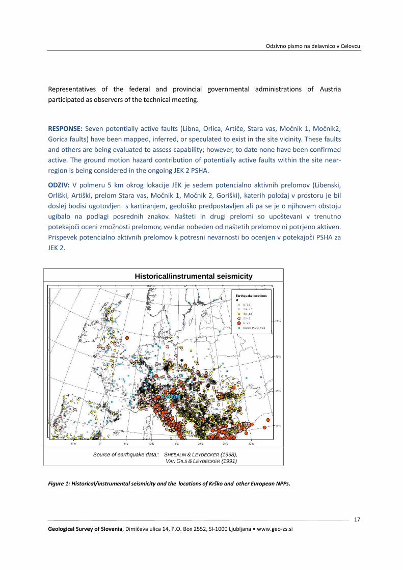
Figure 1: Historical/instrumental seismicity and the locations of Krško and other European NPPs.
Historical/instrumental seismicity
Source of earthquake data:: SHEBALIN & LEYDECKER (1998),
VAN GILS & LEYDECKER (1991)

Odzivno pismo na delavnico v Celovcu
Geological Survey of Slovenia, Dimičeva ulica 14, P.O. Box 2552, SI-1000 Ljubljana • www.geo-zs.si
18
Figure 2: Seismic hazard in Europe and the locations of Krško and other European NPPs.
Seismic hazard in Europe
Source: ESC-SESAME (2003)
19
3. SUMMARY OF WORKSHOP CONTRIBUTIONS
To advance the mutual understanding of the different technical approaches and interpretations
and to benefit from this enormous amount of combined expertise of the contributing scientists,
all participants were asked to prepare presentations addressing their view on the active
tectonics, site seismicity, and its effects on the safety of the NPP Krško. The following paragraphs
include short outlines of the contents of these presentations. All outlines were reviewed by
the authors12.
Remarks printed in italic below the Outline of Contents contain explanations and assessments
added by the author of this report. These comments solely reflect the opinion of the author of
this report.
3.1 Marko Vrabec (University of Ljubljana)
Active tectonics at the Alps – Dinarides junction: Current data and ideas, and possible implications for
the Krško site
Outline of contents: During his talk Marko Vrabec summarized the current plate tectonic
boundary conditions in the region under consideration and provided insight into a regional
seismotectonic model of the Slovenian territory. Active tectonics and seismicity in the region
are driven by the convergence between the Adriatic Plate and stable Europe which amounts to
about 3.5 mm/yr. GPS and geological data prove that fault slip rates of many of the major faults
in the area exceed 1 mm/year (Periadriatic, Lavanttal, Idrija, Sava, and Vodice Fault). Robust
GPS data also indicate that 1 mm/year of NNW-SSE shorting is accommodated across the Sava
Folds in the geographic region around Krško. The presentation further described in great detail
the advanced seismotectonic models which are available for the Sava fault system, the
Sava folds, the Ljubljana basin, and the Idrija fault system.
RESPONSE: Only the maximum estimates of fault slip rate exceed 1 mm/year for the Periadriatic,
Lavanttal, Idrija and Sava Faults; minimum estimations are on the order of 0.1 mm/year (e.g.
Kastelic and Carafa, 2012; Jamšek Rupnik et al., 2012; Basili et al., 2013; Moulin et al., 2016;
Atanackov et al., 2016). Slip rate estimates for the Vodice fault range between 0.1 and 0.5
mm/year (Jamšek Rupnik, 2013).
We advise the reader to compare these values of measured horizontal displacement along the
four most prominent faults within the 200-km region around the possible JEK 2 sites with the
summary of S. Baize's presentation in which 1.7 mm/year of (only) vertical displacement is
attributed to the Artiče fault.
ODZIV: Le pri največjih regionalnih prelomih (Periadriatski, Labotski, Idrijski, Savski) največje
Odzivno pismo na delavnico v Celovcu
Geological Survey of Slovenia, Dimičeva ulica 14, P.O. Box 2552, SI-1000 Ljubljana • www.geo-zs.si
20
ocene hitrosti premikov ob prelomu presegajo 1 mm/let, medtem ko so minimalne ocene reda
velikosti 0.1 mm/leto (e.g. Kastelic in Carafa, 2012; Jamšek Rupnik in sod., 2012; Basili in sod.,
2013; Moulin in sod., 2016; Atanackov in sod., 2016). Ocene hitrosti premikov ob Vodiškem
prelomu so med 0.1 in 0.5 mm/leto (Jamšek Rupnik, 2013).
Bralcu svetujemo primerjavo teh vrednosti (hitrosti premikov ob najizrazitejših atkivnih prelomih
znotraj radija 200 km od potencialnih lokacij JEK 2) z vrednostjo v povzetku predstavitve S.
Baizea, kjer pripisuje Artiškemu prelomu kar 1.7 mm (le) vertikalnega premika na leto.
3.2 Petra Jamšek Rupnik (Geological Survey of Slovenia GeoSZ)
Database of active faults in Slovenia
Outline of contents: The presentation informed about the ongoing activities to collect a
comprehensive database of active faults in Slovenia as a basis for the re-evaluation of seismic
hazard on the national scale. Previous hazard assessments are regarded insufficient as they are
exclusively based on earthquake data. Hazard re-assessments are regarded crucial at the
background of the seismicity in Slovenia with several strong historical earthquakes affecting
the area (Idrija 1511, M=6.8; Villach 1348, M=6.4; Ljubljana 1895, M=6.1; Villach, 1690,
M=5.9; Brežice 1917, M=5.7; Bovec 1998, M=5.7). Most of these earth- quakes were generated
by large or fault systems that generally do not extend into the site near-region of Krško (i.e.
Idrija fault, Ravne fault, and the Periadriatic fault system).
The new parameterized fault database should include all currently known active and potentially
active (Quaternary) faults which are longer than 5 km. Fault parameters considered in the
database include slip rate, fault orientation, fault kinematics, fault dimensions and maximum
earthquake magnitudes (estimated from fault dimensions) which are said to reach up to
Mmax=7.6 for multi- segment ruptures breaking the entire length of the Sava or Idrija fault
(such events are regarded very unlikely) and Mmax=7 for single-segment ruptures.
Remarks: The version of the map of active and potentially active faults shown in the
presentation included four faults (five fault segments) in the near-region of Krško (less than 25
km distance) with estimated slip rates of up to about 0.1 mm/year and maximum
magnitudes reaching up to about Mmax=7.
RESPONSE: The Map of Active and Potentially Active Faults in Slovenia (Atanackov et al., 2016)
contains no active, probably active or possibly active faults within the 25-km radius of the JEK 2
sites for which their lengths would suggest a potential for M>>7 full-length or M≥7 single-
segment ruptures.
ODZIV: Karta aktivnih in potencialno aktivnih prelomov v Sloveniji (Atanackov et al., 2016) ne
vsebuje aktivnih, verjetno aktivnih ali potencialno aktivnih prelomov znotraj polmera 25 km
okoli potencialnih lokacij za JEK 2, katerih dolžine bi nakazovale potencial za potres z M>>7 ob
multisegmentni aktivaciji po celi dolžini preloma ali za potres z M≥7 ob aktivaciji posameznega

Odzivno pismo na delavnico v Celovcu
Geological Survey of Slovenia, Dimičeva ulica 14, P.O. Box 2552, SI-1000 Ljubljana • www.geo-zs.si
21
segmenta.
3.3 Stephane Baize (IRSN)
Active Tectonics in the Krško Region and IRSN perspectives
Outline of contents: In the first part of his presentation Stephane Baize presented a concise
and credible kinematic and seismotectonic model of the Krško Region highlighting the
importance of the Orlica and Artiče faults, which are lo- cated at very close distances to the
NPP. According to the model which was proposed the consortium gathering IRSN, BRGM and
GeoZS, the two sinistral faults are linked via a restraining bend forming the Artiče flexure.
Evidence for the current uplift with a rate of about 1.7 mm/year is provided by geomorpholog-
ical data and uplifted fluvial sediments. The surface flexure is related to a blind fault at depth
which strikes towards the site of the Krško NPP and may continue into the Libna fold. In this
tectonic scenario the Libna fault may be regarded as a small dextral tear fault at the
termination of Artiče flexure which delimits two parts of the Libna fold. The Orlica-, Artiče-
and the blind fault are regarded as the main seismotectonic structures in the near-region of
Krško and were used to update previous seismogenic source models for the assessment of
vibratory ground motion hazards (geometry, Mmax, slip rates). The updated model formed the
basis of a hazard assessment completed in 2010 (GG&S Report 2010). The results of this report
are not public.
RESPONSE: The basis for the uplift rate of 1.7 mm/year was not provided and conflicts with
estimates determined as part of the BRGM/GeoZS/IRSN/ZAG consortium and other known
studies. In the BRGM/GeoZS/IRSN/ZAG consortium Geology report (Bavec et al., 2010a), in his
contribution titled MORPHOMETRIC ANALYSIS OF THE SITE VICINITY AND NEOTECTONIC
IMPLICATIONS, S. Baize states on page 96: “the Artiče structure is suspected to be the surface
expression of the Southern limit of a large-scale block uplifting (up to the Orlica hills). The rate of
uplifting is low, at a maximum of 150 m during the last 5 Ma (maximum age of Plio-Quaternary
base surface) or 1.5 Ma (minimum age of Plio- Quaternary top surface according to Verbič, 2005)
(i.e. 0.03 to 0.1 mm/a).”
Further, in the Seismic Source Models report co-signed by GeoZS, IRSN and BRGM (Bavec et al.,
2010b) it is stated on page 51: "Slip rate (0.12 and 0.06 mm/yr) is calculated from the 120 m
vertical (structural) relief in the Plioquaternary deposits (estimated to 1,000,000 to 2,000,000
years) across the Artiče fault."
The GG&S Geology Report (Bavec et al., 2010a) has been published on Slovenian Nuclear Safety
Administration (SNSA) website since 2013.
ODZIV: Osnove za oceno dviganja 1.7 mm/leto niso bile predstavljene in so v nasprotju z
ocenami iz raziskav konzorcija BRGM/GeoZS/IRSN/ZAG (2010) in ostalimi znanimi raziskavami. V
Odzivno pismo na delavnico v Celovcu
Geological Survey of Slovenia, Dimičeva ulica 14, P.O. Box 2552, SI-1000 Ljubljana • www.geo-zs.si
22
geološkem poročilu (Bavec in sod., 2010) konzorcija BRGM/GeoZS/IRSN/ZAG S. Baize v svojem
prispevku MORPHOMETRIC ANALYSIS OF THE SITE VICINITY AND NEOTECTONIC IMPLICATIONS
na strani 96 piše: »domnevamo, da je Artiška struktura površinski izraz na južnem robu dviganja
bloka velikega merila (do Orliškega hribovja). Hitrost dviganja je nizka, maksimalno 150 m v
zadnjih 5 milijonih leti (največja starost spodnje meje Pliokvartarja) ali 1.5 milijonih let
(najmanjša ocenjena starost zgornje meje Pliokvartarja po Verbič, 2005) (t.j. 0.03 do 0.1
mm/leto)«.
Nadalje, na strani 51 v Poročilu za model potresnih virov (Seismic Source Model report),
podpisan s strani GeoZS, IRSN in BRGM (Bavec in sod., 2010b) piše: »Hitrost premikov (0.12 do
0.06 mm/leto) je izračunan iz 120 m vertikalnega (strukturnega) reliefa v Pliokvartarnih
sedimentih (ocenjenih na starost 1 do 2 milijona let) preko Artiškega preloma.«.
Geološko poročilo projekta GG&S (Bavec et al., 2010a) je objavljeno na spletni stran URSJV od
leta 2013.
The second part of the presentation summarized the consortium’s (IRSN, BRGM, GeoZS)
conclusions 2011 on the paleoseismological trenching of the Libna fault, which is located at
close distance to the NPP. Trenching revealed clear evidence for faulting of sediments which are
younger than 200,000 years13.
Physical age dating is confirmed by the finding of a human artefact (Mousterian tool). Trench
data provide evidence for Pleistocene and even Holocene strike-slip faulting as fault planes
include Holocene soil. Reopening of the fault plane must therefore have happened in the
Holocene. These observations may be indicative for coseismic and recurrent displacements. The
Libna fault should consequently be considered capable in line with the definition by IAEA (2010).
The interpretation was validated by expert consulting by Daniela Pantosti (INGV) who
confirmed that fault slip was triggered either by tectonic reactivation of the fault or by ground
shaking induced by an earthquake which occurred at another nearby fault. According to
Stephane Baize and the other members of the geological team of the 2011 Consortium the
observations in the Libna trenches cannot be explained by landsliding.
RESPONSE: This section is extensively debated in the GeoZS/IRSN/BRGM report on
paleoseismological studies on the Libna fault (Bavec et al, 2011, 2013). Faulting younger than
200,000 years is one of the statements that was disputed and on which the team did not agree.
The dispute is described in the report. Moreover, later age dating (by a method that is here
referred to as "physical") showed that such low age for the Plio-Quaternary sediment is not
feasible. If 200 000 years refers here to the age of the Mousterian tool, it has to be noted that its
position in the sediment was heavily debated and there was no consensus between the IRSN and
GeoZS teams regarding the potential to date the sediment with it.
Odzivno pismo na delavnico v Celovcu
Geological Survey of Slovenia, Dimičeva ulica 14, P.O. Box 2552, SI-1000 Ljubljana • www.geo-zs.si
23
It is clearly stated on page 36 in the GeoZS/IRSN/BRGM report (Bavec et al., 2011, 2013) that
these options are also discussed (quote):
• the human activity that produced the silex artefact is isochronous with the silt (either this
formation is colluvial or fluvial),
• bioturbation may be the cause of a deep infiltration,
• human activity isochronous with deposition of the (uppermost) silt,
• infiltration into desiccation or slope movement-related cracks,
• artifact was dragged down from surface by excavator during trenching.
Furthermore, there was no agreement on whether the observations in the Libna trenches could
be explained by coseismic or aseismic slip.
ODZIV: Tej temi je namenjena obsežna razprava poročila GeoZS/IRSN/BRGM o
paleoseizmoloških raziskavah na Libenskem prelomu (Bavec in sod., 2011, 2013). Prelamljanje
mlajše od 200.000 let je ena od trditev, o kateri se avtorji poročila niso bili soglasni in je to
zapisano v poročilu. Kasnejše določanje starosti sedimenta (z metodo, ki je tukaj navedena kot
"fizikalna") je pokazalo, da tako majhna starost Pliokvartarnega sedimenta ni možna. Nadalje;
če se starost 200.000 let v tem primeru nanaša na najdeno Mousteriensko kamnito orodje,
izpostavljamo da je bila lega tega orodja v sedimentu predmet intenzivne razprave in da med
ekipami IRSN in GeoZS ni bilo soglasja glede primernosti/potenciala za datacijo sedimenta s
tem orodjem.
Na strani 36 v poročilu GeoZS/IRSN/BRGM (Bavec in sod., 2011, 2013) so tako navedene
različne možnosti, med katerimi nobena ni ovrednotena kot bolj verjetna:
človeška aktivnost je bila sočasna (izohrona) z nastankom melja in je ta formacija bodisi
koluvialna ali fluvialna,
možen vzrok za globoko infiltracijo artefakta je bioturbacija,
človeška aktivnost je izohrona z odložitvijo zgornjega melja,
infiltracija artefakta v izsušitvene razpoke ali razpoke povezane s pobočnimi masnimi
premiki,
artefakt je v sedanjo lego potegnil bager med kopanjem izkopa.
Ekipa ni bila soglasna tudi v oceni, če je opazovanja v izkopih na Libni možno pojasniti izključno
s koseizmičnim ali aseizmičnim premikom oz. premikanjem, kar je dokumentirano v poročilu.
Remarks: IRSN was actively involved in the assessment of potentially capable faults in the

Odzivno pismo na delavnico v Celovcu
Geological Survey of Slovenia, Dimičeva ulica 14, P.O. Box 2552, SI-1000 Ljubljana • www.geo-zs.si
24
Krško area between 2007 and 2012. At this time the Institute was part of an expert
consortium together with BRGM, ARSO and GeoZS. Work in the consortium ended due to a
disagreement with GEN Energija on the necessity to acquire new data. The acquisition of
additional geological data was re- garded necessary by IRSN.
The presentation stressed the importance of the Orlica- and Artiče faults and the blind fault
below the Artiče flexure for the assessment of seismic hazards. It further concluded that
trenching of the Libna fault provided strong indications for repeated fault slip in the last 200,000
years and in the Holocene (<14,000 years). This interpretation is not shared anymore by the
Slovenian Geological Survey and Rizzo Assoc. who after 2012 question the reliability of age
dating (although physical age dating is confirmed by different methods and the finding of
human artefacts) and relate the surface displacement observed in the trench to land- sliding
although the observed fault geometries are apparently not in line with such an
interpretation.
RESPONSE: The reliability of the Libna trench age dating was debated not only after 2012, but
originally in the report co-signed by GeoZS, IRSN and BRGM (Bavec e tal., 2011, 2013). Later
cosmogenic radionuclide (CRN) dating (RIZZO, 2014) confirmed the GeoZS position correct and
this was presented at the workshop. RIZZO also states that certain features on Libna Hill are first
related to karst activity and landsliding.
ODZIV: Zanesljivost datacij v Libenskih izkopih je bila predmet razprave ne le po letu 2012,
ampak tudi že v prvotnem poročilu, ki so ga so-podpisali raziskovalci GeoZS, IRSN in BRGM
(Bavec et al., 2011, 2013). Kasnejša datacija s kozmogenimi radionuklidi (RIZZO, 2014) je potrdilo
stališče GeoZS, kar je bilo predstavljeno tudi na delavnici. RIZZO v svojem poročilu tudi navaja, da
so nekatere oblike na Libni v prvi vrsti povezane z zakrasevanjem in plazenjem.
3.4 Miloš Bavec (Geological Survey of Slovenia GeoZS)
Seismotectonic characteristics of the Krško Basin in light of past and ongoing geologic investigations
Outline of contents: Miloš Bavec, geologist at the Geological Survey of Slovenia and manager of
the recent geologic project in Krško for GeoZS, summarizes the contents of previous and on-going
geological and geophysical investigations in the Krško basin and its surrounding. Past and
current efforts include the acquisition of 2D reflection seismic, shallow geophysics, geological
mapping and the analysis of earthquake data. Analyses further comprise the interpretation of
high-resolution digital elevation models (LiDAR-data) with quantitative geomor- phological
techniques to identify active faults by lineament analyses, analyses of mountain-front sinuosity,
channel sinuosity, stream profiles and drainage ba- sin morphology. Earthquake records are
shown to be of limited use for identify- ing active faults. Seismicity is scattered and only three
faults can reasonably be associated with earthquake clusters. Analyses highlight the importance
Odzivno pismo na delavnico v Celovcu
Geological Survey of Slovenia, Dimičeva ulica 14, P.O. Box 2552, SI-1000 Ljubljana • www.geo-zs.si
25
of NE- SW striking sinistral strike-slip faults.
Miloš Bavec further explains that four different seismic source zone models were used for a
seismic hazard assessment performed in 2010 (GG&S Report 2010). Accordingly, Model A used
in this study consists of four seismic zones (Dinarides, Sava, two sub-zones of the Mid
Hungarian Zone [MHZ]), Model B comprises of three zones (Dinarides, Sava, MHZ), Model C
includes two zones (Dinarides, Sava including MHZ), and Model CRO is seismicity-focused and not
structurally defined. A fault specific model of seismic sources (with a back- ground
seismicity zone) was also elaborated and used in calculation as one of the alternatives. He
further informs that a novel probabilistic seismic hazard assessment (PSHA) shall be initiated for
the NPP Krško.
Remarks: The NE-SW striking sinistral strike-slip faults mentioned in the presentation
correspond to the Orlica- and Artiče fault highlighted in the presentation by Stephane Baize. The
cited seismic hazard study (GG&S Report 2010) is not public.
RESPONSE: The cited seismic hazard study (GG&S Geology Report; Bavec et al., 2010) is public
and has been available on the SNSA web page since March 29th 2013.
ODZIV: Citirano poročilo (GG&S Geology Report; Bavec et al., 2010) je javno in dosegljivo na
spletni strani URSJV od 29. marca 2013.
3.5 K. Michel Cline, M. Logan Cline (RZZO Assoc.)
Probabilistic fault displacement hazard analysis – Krško NPP 2 sites – Slovenia
Outline of contents: The authors report on the outcome of a probabilistic fault displacement analysis
(PFDHA) which was performed as part of the evaluation of two sites to support decision making by the
utility and regulator regarding the safety of the site for the construction of a possible new NPP
(“Krško 2”) adjacent to the existing plant. The approach used follows that of Petersen et al. (2011),
with considers both on fault and off fault displacement for all faults considered in the analysis. 11
faults with assessed probabilities of being active be- tween P=0.3 and P=1 were considered for the
analysis [Remark: Probability P=1 is assigned to proven active faults]. The mean annual probability
of exceeding 0.1 – 50 cm of surface displacement within a 200 x 200 m area at each site was
calculated. The study procedure came to the conclusion that displace- ments between 5 and 10 cm
(such displacements are generally considered by nuclear engineers to be significant for an NPP)
are extremely unlikely with mean annual frequencies of exceedance less than 10-8 to 10-9.
Remarks: The study by Rizzo Assoc. exclusively addresses the hazard of sur- face displacement, the
hazard of vibratory ground shaking is not considered. Rizzo’s study was reviewed by the independent
experts L. Serva, C. Costantino and A. Gürpinar who state that: “A PSHA [for ground shaking hazards]
Odzivno pismo na delavnico v Celovcu
Geological Survey of Slovenia, Dimičeva ulica 14, P.O. Box 2552, SI-1000 Ljubljana • www.geo-zs.si
26
study was recently completed for the KRSKO site and a new study is currently being conducted. There
are many common input parameters between the PSHA and PFDHA [for fault displacement hazards]
related to fault characteristics, recurrence values, etc. The consistency of these studies need to be
checked and differences (if any) need to be appropriately justified.” Seismic hazard assessment for the
existing NPP must therefore properly account for the finding of these active faults.
RESPONSE: The input parameters for the PFDHA were provided by the same GeoZS professionals who
participated in the subject PSHA. The same faults that were considered for the PSHA were included in
the PFDHA. Fault inputs for the PFDHA used the same Tectonic Map of the Krško Basin as was used in
the PSHA; however, the faults modeled in the PFDHA were conservatively assumed to have some
probability of their being active, even if there was no reliable evidence to confirm their activity. The JEK
2 PSHA, currently underway, is considering the inputs of the previous PSHAs, and new data that has
been compiled since the previous PSHAs were completed.
Dr. Sirovich (Università di Trieste) commented during the meeting that the PFDHA only addresses
surface fault rupture along a fault and not ground tilting/deformation, and the hazard it poses to a NPP.
He expressed concern about the safety of the NPPs critical structures. At the time the PFDHA was
completed the focus was on the probability of exceeding a defined amount of surface fault
displacement within a defined area surrounding the nuclear island. New guidance has been issued by
the American Nuclear Society (ANSI/ANS Standard 2.30-2015) that addresses both surface fault rupture
and ground deformation; however, the PFDHA results suggest that the probability of surface fault
rupture is below regulatory concerns. This would likely be the same for surface deformation. The
PFDHA informs the design engineers of the probability of surface fault rupture. Surface fault rupture is
only one of many factors taken into consideration regarding the safety of critical facilities.
ODZIV: Vhodne parametre za PFDHA so priskrbeli isti predstavniki GeoZS, ki so sodelovali tudi v PSHA. V
PSHA so upoštevani isti prelomi kot v PFDHA. Vhodni podatki za prelome v PFDHA so vzeti iz Tektonske
karte Krške kotline, ki je uporabljena tudi v PSHA, vendar je za PFDHA konzervativno privzeto da imajo
prelomi enako verjetnost aktivnosti, čeprav za njihovo aktivnost ni zanesljivih podatkov. Trenutno
potekajoča JEK 2 PSHA upošteva vhodne podatke predhodnih PSHA in novejše podatke.
Dr. Sirovch (Università di Trieste) je med delavnico komentiral, da PFDHA pri oceni tveganja za
jedrsko elektrarno upošteva le površinske pretrge vzdolž preloma in ne upošteva
deformacije/nagiba površine. Izpostavil je zaskrbljenost glede varnosti kritičnih struktur v jedrski
elektrarni. PFDHA se je osredotočila na verjetnost preseganaja določene vrednosti površinskega
premika ob prelomu v vnaprej definiranem območju okoli jedrskega dela. Ameriško jedrsko
združenje je izdalo nove smernice (ANSI/ANS Standard 2.30-2015), ki obravnavajo površinski
pretrg ob prelomu in deformacijo površja. Rezultati PFDHA v Krškem nakazujejo da je verjetnost
površinskega pretrga manjša od mejne. Isto verjetno velja za deformacijo površja. Rezultat PFDHA
je verjetnost površinskega pretrga ob prelomu, kar je le eden izmed številnih faktorjev, ki so
upoštevani pri ovrednotenju varnosti kritičnih objektov.

Odzivno pismo na delavnico v Celovcu
Geological Survey of Slovenia, Dimičeva ulica 14, P.O. Box 2552, SI-1000 Ljubljana • www.geo-zs.si
27
In his presentation M. Cline, however, stressed that the performed study as- sumed capable
faults in the near region of the site rather than confirming them. It was explained that this
more conservative approach was used because the analysis focused on site suitability and not
on design purposes. This raises the question why very conservative assumptions should be
made for the capable fault analysis (PFDHA) while much less conservative assumptions
should be admissible for the analysis of vibratory ground motion hazards (PSHA).
RESPONSE: The term “conservative” was used to characterize certain assumptions that were made in
the PFDHA that would lead to higher predicted frequencies of surface displacement exceedance than if
a realistic assessement was used. For example, faults for which no reliable evidence existed that they
were active were, nevertheless, treated as active. The objective was to carry out a “what if” analysis:
What would be the surface displacement hazard if the faults were active. Because the focus of the
study was whether possible sites for JEK 2 were suitable, it was acceptable to use conservative
assumptions: If suitability can be demonstrated using conservative assumptions then use of more
realistic assumptions would also lead to a demonstration of suitability. If the purpose of the study was
to determine a design basis or to support a seismic probabilistic safety assessment, conservative inputs
would be inappropriate. For a design basis, an appropriately conservative annual frequency of
exceedance (i.e., hazard level) is selected (e.g., mean of 10-4) or prescribed by regulation, assuming the
probabilistic hazard analysis inputs are realistic. Similarly, for a PSA, the hazard results should be based
on a realistic (and not conservative) assessment of uncertainties such that seismic-related risks can be
compared to risks from other external and internal initiators. For the ongoing PSHA, inputs will be based
on realistic assessments, unless it can be demonstrated that the impact on hazard of conservative inputs
is negligible.
ODZIV: Pojem "konzervativno" je bil uporabljen za opis nekaterih predpostvk v PFDHA, ki v izračunu
vodijo k večji napovedani frekvenci preseganja površinskega premika ob prelomih, kot pa če bi
uporabili bolj realistične ocene. Na primer: prelomi, za katere ni bilo zanesljivih dokazov o aktivnosti so
v PFDHA obravnavani kot aktivni. Namen izračuna je bil izvesti "kaj če" analizo. Ocenjevali smo torej,
kakšna bi bila nevarnost za površinski premik ob prelomih, če bi bili vsi prelomi aktivni. Ker je bil PFDHA
namenjen oceni primernosti lokacije, je bilo sprejemljivo uporabiti takšne konzervativne predpostavke.
Če tak izračun nakazuje na primernost lokacije, bi namreč tudi izračun, utemeljen na bolj realističnih
predpostavkah, v takem primeru lahko pokazal primernost lokacij. Če pa bila, nasprotno, študija
namenjena projektiranju objekta ali verjetnostnemu izračunu potresne nevarnosti, bi bili konzervativni
vhodni podatki neprimerni. Pri projektiranju morajo biti vhodni podatki za verjetnostni izračun
realistični, saj je zahtevana ocena verjetnosti postavljena ustrezno nizko (npr. 10 -4 letno oz. jo
predpisuje regulatorni organ). Podobno morajo biti tudi pri rednih ocenah nevarnosti (PSA) negotovosti
ocenjene realistično (in ne konzervativno). Na tak način je mogoče potresno nevarnost obravnavati
skupaj z ostalimi potencialnimi nevarnostmi. Vhodni podatki za potekajoči PSHA bodo temeljili na
realističnih ocenah. Izjememoma bodo ocene lahko tudi konzervativne, a le v primerih, ko bo mogoče
Odzivno pismo na delavnico v Celovcu
Geological Survey of Slovenia, Dimičeva ulica 14, P.O. Box 2552, SI-1000 Ljubljana • www.geo-zs.si
28
dokazati, da taka sprememba ne bo vplivala na oceno nevarnosti.
3.6 Wolfgang Lenhardt (ZAMG Vienna)
Cross-border monitoring of seismic activity
Outline of contents: The author reports on the coverage of the Austrian seis- mic network, its
linkage with the seismic observation networks in Austria’s neighbouring countries, and data
exchange with these countries. The presentation provides insight into the detection threshold of the
network in Austria.
3.7 Marijan Herak, Davorka Herak, Bruno Tomljenović (University of Zagreb)
Seismicity and Neotectonics in the Greater Zagreb Area
Outline of contents: In the first part of the presentation Marijan Herak informs about the seismicity
in the Croatian territory east of the NPP Krško. Historical earthquakes in the area reach up to about
M=6. A significant effort was undertaken to relocate earthquakes which occurred between 2004 and
2014. The results revealed new and more reliable hypocenter depth distributions showing that all
earthquakes occurred in the upper crust. First arrival analyses (fault plane solutions) show N- or S-
dipping thrust faults (in particular in the area be- tween the Slovenian border and the Medvednica
Mountain) and NW-striking dextral strike-slip faults as seismic sources. Normal faulting is not
observed. Shortening directions are uniformly oriented N-S. Gutenberg-Richter analyses for the
greater Medvednica Mountain area indicate that one M=6 earthquake occurs about every 500 years.
The hazard contribution from this area for Krško is PGA=0.10 g and PGA=0.28 g for the return periods
of 75 years and 10,000 years, respectively. [Remark: It is understood that this would be the
hazard at the Krško site if no other seismic sources were considered.]
In the second part Bruno Tomljenović discusses the active tectonics of the Medvednica
Mountains and the greater Zagreb area. He shows that the main structural elements of the
Krško basin, the ENE-WSW trending Krško syncline and the Orlica-Artiče uplift, extend to ENE
into Croatia. Seismic and geological data show that the Medvednica Mountains are thrust
towards the N over a syn- cline filled with Pliocene and Quaternary sediments. The location of
the thrust coincides with the relocated hypocenters of earthquakes which occurred be-
tween 12 and 5 km depths. The fault surface of the Medvednica thrust is estimated with 300
km².
Remarks: The Medvednica thrust is located at a distance between 26 and 32 km from the
Krško site. The fault surface of 300 km² suggests that the fault is capable of producing

Odzivno pismo na delavnico v Celovcu
Geological Survey of Slovenia, Dimičeva ulica 14, P.O. Box 2552, SI-1000 Ljubljana • www.geo-zs.si
29
earthquakes up to magnitude Mmax=6.6. It appears that previous seismic hazard analyses for
the Krško site did not consider the fault as a seismic source.
RESPONSE: The detailed seismotectonic model was made in 2010 for the 25-km radius, which
does not include the Medvednica thrust (North Medvednica Boundary Fault - NMBF). All seismic
sources in the >25 km radius were included in the background seismicity. In the 2010 study (Bavec
et al., 2010), the Medvednica source was encompassed within the Sveta Nedelja - Zagreb seismic
source zone. NBMF is being considered in the ongoing PSHA.
ODZIV: Leta 2010 (Bavec 2010a) je bil izdelan podroben seizmotektonski model za polmer 25 km
okoli JEK, ki ne vključje preloma Medvednica (North Medvednica Boundary Fault - NMBF). V
okviru študije leta 2010 so bili vsi viri izven 25-km radija vključeni v seizmično ozadje. V isti študiji
je bil prelom NMBF vključen v seizmični vir Sveta Nedelja – Zagreb. Prelom NMBF je upoštevan v
trenutni PSHA.
3.8 Mladen Živčić (Slovenian Environment Agency)
Seismicity of the Krško region
Outline of contents: The presentation provides information on the history of the earthquake
observation network in Slovenia. Accordingly, systematic earth- quake records were made in the
time between 1895 (starting after the Ljubljana earthquake) and 1918. Between 1918 and 1958
data were collected only spo- radically. Seismic stations were established as follows: Ljubljana
1897 – 1918 (no records preserved); Zagreb from 1906 onwards; re-establishment of a
seismograph in Ljubljana in 1958; installation of seismographs at Cernica 1973, Vojsko 1984, and
Bojanci 1986. After the 1989 Krško earthquakes (28. December, M=3.6; 30. December, M=2.6,
epcenter next to the NPP) seven additional stations were installed between 1990 and 2003.
Stations were supplemented by the accelerometric network NEK II in 2008. The completeness
of earthquake records was said to be very poor for the time interval between 1918 and about
1960. Completeness increased slowly from 1963. The strongest pre- instrumental earthquakes
in Slovenia occurred in NW Slovenia 1511 (Intensity I=X), Krško 1628 (I=VII), Carniola 1632
and 1640 (I=VII and I=VI–VII),
Medvednica 1880 (I=VIII), and Brežice 1917 and 1928 (I=VIII and I=VII). The currently used
earthquake catalogue is the NEK 2015 catalogue covering an area of 200 km perimeter around
Krško and Friuli. The catalogue is harmonized using moment magnitude and lists events with
Mw>3.5. However, most of the original data is based on macroseismic intensity.
The strongest recorded earthquake in the Krško area occurred on 29. January 1917 (Mw=5.0,
MLH=5.7, I0 =VIII). It was analysed by a commission of the K&K Academy of Sciences.

Odzivno pismo na delavnico v Celovcu
Geological Survey of Slovenia, Dimičeva ulica 14, P.O. Box 2552, SI-1000 Ljubljana • www.geo-zs.si
30
Fault plane solutions from recent earthquakes around Krško include thrust faults (N- and S-
dipping thrusts) and strike-slip faults (NW-striking dextral and NE- striking sinistrale faults). P-
axes and shortening directions inferred from the fault plane solutions are oriented mostly N-S.
Remarks: The presentation provided detailed information on the completeness of earthquake
observations in Slovenia showing that instrumental earthquake records are complete for 50
years at the best. Such short data records limit the reliability of seismic hazard assessments for
long recurrence intervals14 very significantly as it is not allowable to extrapolate statistics over
several orders of magnitude (i.e., from 50 to more than 10,000 years). It is further concluded
that the accuracy of hypocentre determination is insufficient for seismotectonic int erpretation
and that large uncertainties exist with respect to the determination of the magnitudes of
strong historical earthquakes. The insufficiency of the earthquake data stresses the need of
accurate geological and paleoseismological data as input for the seismic hazard assessment.
RESPONSE: As part of the ongoing PSHA, geological and paleoseismological data are considered
in developing inputs and characterizing their uncertainty.
ODZIV: Geološki in paleoseizmološki podatki so uporabljeni za pripravo vhodnih podatkov in
oceno njihove negotovosti v okviru potekajoče PSHA.
3.9 Esther Hintersberger (University Vienna)
Estimating paleo-earthquake parameters from multiple trench observations
Outline of contents: An important aspect of fault characterisation for seismic hazard
assessment are the parameters of pre-historical earthquakes derived from paleoseismological
trenching. Especially in regions with low or moderate seismicity, paleomagnitudes are
normally much larger than those of historical earthquakes and therefore provide essential
information about the seismic potential and expected maximum magnitudes of a certain region.
The presentation introduced a novel method for deriving seismological parameters of
paleo- earthquakes based on a probabilistic approach combining observations in sev- eral
trenches across the same fault to better constrain the possible range of parameters such as
earthquake magnitude. The contribution further showed that by combining several
observations, the associated uncertainty for the magnitude of a paleoearthquake decreases
rapidly, seemingly with a minimum of 4 to 6 observation points to obtain highly reliable results.
Tests of the method with data from earthquakes with known magnitude and surface
displacement reproduced magnitudes which are promisingly close to the instrumentally
determined magnitude. Therefore, the approach is a suitable method to combine observations
from different locations to derive paleo-earthquake parameter values ac- counting for the
natural variances of observed along-strike surface displacement.
Odzivno pismo na delavnico v Celovcu
Geological Survey of Slovenia, Dimičeva ulica 14, P.O. Box 2552, SI-1000 Ljubljana • www.geo-zs.si
31
Remarks: The presentation showed that the uncertainties of paleoseismological interpretations
made in single trenches can be reduced very significantly by using data from multiple trenches.
The approach is particularly suitable to reduce the uncertainties of the assessment of the Libna
fault near Krško.
3.10 Vanja Kastelic (INGV Roma)
Contribution of active fault and geodynamic data to seismic hazard assessment
Outline of contents: In her presentation Vanja Kastelic introduced methods for physical models-
based seismic hazard studies in which predictions of the future seismicity are mainly or
exclusively based on active fault and geodynamic data instead of historical/instrumental
earthquake observations. The approach uses fault properties (dimension, orientation,
kinematics and slip rate) to derive seismic moment rates. Earthquake rates for single faults or
fault elements are subsequently computed using the SHIFT hypothesis (Bird and Liu 2007).
The method was applied to three of the active faults identified in the vicinity of the NPP
Krško, the Hrastnik-, Orlica- and Libna fault, using the fault parameters published by CLINE et
al (2015). The results show the importance of good knowledge of fault geometry and even
more so of the fault slip rates, as with just considering the used data, the expected number
earthquakes for different magnitude varies significantly. Mrs. Kastelic also pointed out the need
of developing self-consistent active fault models (considering 3D fault geometries) and that
care is needed when estimating fault slip rates from surface data as the re- sults may also be
influenced by non-tectonic processes.
In general, the results of the study indicate that strong earthquakes (M=6 and higher) are
expected to occur on the studied faults at time intervals of several hundred to few thousand
years only. The purely physics-based predictions were validated by the historical and
instrumental earthquake record. Vanja Kastelic concluded that active fault and geodynamic
data are a valid input for probabilistic seismic hazard analysis (PSHA). For this purpose, it is of
key importance to have good knowledge of fault geometry, kinematics, and slip rates.
Remarks: The contribution introduced a novel physics-based approach of seismic hazard assessment
and applied the methodology to estimate the expected number of future earthquakes and their
related recurrence periods for the Hrastnik-, Orlica- and Libna fault near Krško. The estimate
revealed that, based on the currently known fault data, severe earthquakes with M>6 are expected to
occur in intervals of centuries to few thousand years. If proven by ad- ditional investigations such
earthquake recurrence intervals would be highly rel- evant for the seismic hazard of Krško. Future
active fault investigation should consider this fact and strive for a good knowledge of active faults as
this data is of key importance for a reliable physics-based seismic hazard model.

Odzivno pismo na delavnico v Celovcu
Geological Survey of Slovenia, Dimičeva ulica 14, P.O. Box 2552, SI-1000 Ljubljana • www.geo-zs.si
32
RESPONSE: Research on this matter is being undertaken within the scope of the ongoing PSHA.
ODZIV: Raziskave s tem namenom potekajo v okvirju trenutne PSHA.
3.11 Livio Sirovich, Franco Pettenati (Università di Trieste), Giovanni Costa, Peter Suhadolc (Istituto Nazionale di Oceanografia e di Geofisica Sperimentale, O.G.S)
Questions and doubts on the seismic hazard of the Krško NPP site
Outline of contents: In their presentation the authors highlighted the need for a comprehensive seismic
hazard assessment for the site. To support their view- point they cited a publicly available document
of IRSN saying that IRSN considers “the Libna capable fault … in the vicinity of the existing Krško I plant
site … as well as its potential structural relationship to nearby faults …” of utmost im- portance for
the safety of the existing plant.
The presentation showed that the site is located in a seismically active region with the 1917 Brežice
earthquake as the strongest known historical event. For this earthquake different earthquake
catalogues (Ribarič 1982, Grünthal & Wahlström 2012) list magnitudes ranging from Mw=5.7 to 6.2.
However, this earthquake was either not included in a seismicity dataset which has been pre- sented
to the Slovenian Nuclear Safety Administration by GEN energija, or it was included with a too low
magnitude15. They also noted that the earthquake has not been investigated with up-to-date
methodology (e.g., intensity-based source inversions to identify the ruptured fault), and that an
Ml=4.2 earthquake occurred on 01. November 2015 in the same area (c. 10 km from Krško).
RESPONSE: The Brežice earthquake has been included in all catalogues and datasets relevant to seismic
hazard calculations in Krško basin. Sirovich and co-authors do not provide a technical basis for their
assertion that the earthquake was included in datasets with a too low magnitude. An earthquake
catalog for the Krško region deveoped as part of the ongoing PSHA study used the latest magnitude
conversion relations and data for the 1917 earthquake to determine a Mw of 5.7 (Živčić et al., 2015).
OPIS: Brežiški potres je vključen v vseh katalogih in naborih podatkov relevantnih za izračun parametrov
potresne varnosti v Krški kotlini. Sirovich in soavtorji ne navajajo osnove za njihovo mnenje, da je
magnituda tega potresa v katalogih in naborih podatkov prenizka. Katalog potresov, izdelan za trenutno
PSHA raziskavo, ki je za magnitudno pretvorbo uporabil najnovejše relacije, za Brežiški potres 1917
podaja magnitudo Mw 5.7 (Živčić in sod., 2015).
In the last part of their presentation Livio Sirovich and his co-authors stressed the importance to
seismic hazard of the Orlica-, Artiče- and Libna faults in the vicinity of the Krško plant. In the
discussion about the tectonic significance of the observations made in the paleoseismological trench
across the Libna fault they expressed strong doubts on interpreting the excavated Quaternary faults
Odzivno pismo na delavnico v Celovcu
Geological Survey of Slovenia, Dimičeva ulica 14, P.O. Box 2552, SI-1000 Ljubljana • www.geo-zs.si
33
as the results of landsliding. They substantiated their doubts by the analysis of LIDAR-derived digital
elevation data. Although this data confirms the existence of mass movements on the Libna hill, the
direction of the landslide seems hardly compatible with the kinematics of the fault.
RESPONSE: The issues related to abovementioned faults including results of paleoseismological and
geomorphic studies were thoroghly described at the workshop and are also partly presented in the
report REP 0612. Investigation of these faults has been a focus in all relevant studies of the Krško basin.
There is no basis to suggest the landslides are in a direction inconsistent with fault kinematics.
ODZIV: Teme, povezane z zgoraj navedenimi prelomi, vključno z rezultati paleoseizmoloških in
geomorfoloških raziskav, so bile temeljito opisane na delavnici in so delno predstavljene v poročilu REP
0612. Raziskave na teh prelomih so bile v žarišku vseh pomembnih študij v Krški kotlini. Nobene osnove
ni za trditev, da usmeritev zemeljskih plazov na Libni ni skladna s kinematiko prelomov.

34
4. CONCLUSIONS
During the workshop it appeared that a common view of the experts exists on the seismotectonic
boundary conditions of the Krško region16. Convergence across the geographic area under
consideration is significant. GPS derived velocity fields suggests about 3 to 3.5 mm/year convergence
between the Adriatic plate and stable Europe (M. Vrabec). Out of this general convergence about
~1 mm/year of N-S-directed shortening is currently accommodated by seismotectonic processes
across the Sava Folds area (i.e., the region around Krško; M. Vrabec). N-S-directed compression
causes seismic slip on NE-striking sinistral strike-slip faults, NW-striking strike-slip dextral faults, and
N- or S-dipping thrust faults (M. Vrabec, B. Tomljenović, M. Živčić, V. Kastelic).
RESPONSE: The range of results is slightly larger than the 3 to 3.5 mm/year stated above: 2 to 4
mm/year (e.g., Weber et al. 2010; Nocquet, 2012).
ODZIV: Razpon rezultatov je nekoliko večji od navedenega (3 do 3.5 mm/leto): 2 do 4 mm/leto (e.g.,
Weber in sod., 2010; Nocquet, 2012).
The most important faults in the region around Krško belong to these fault sys- tems. Faults
important for hazard assessment include the NE-striking Orlica- and Artiče faults (M. Cline,
S. Baize), which may be linked via a restraining bend and a blind thrust fault below the Artiče
flexure (S. Baize), the NW-striking Libna fault, the NW-striking Hrastnik fault (V. Kastelic) and
the Medvednica thrust (B. Tomljenović). It appeared that all experts generally agreed on the
existence of these faults. All faults are located at close distances to the NPP site. Slip velocities
of the faults are estimated to be in the order of magnitude of0.1 mm/year (P. Jamšek
Rupnik, M. Cline). Based on the dimensions of these faults maximum earthquake magnitudes
of up to about Mmax=7 may be expected (P. Jamšek Rupnik, M. Cline). Faults in the near-
region of Krško are included in the database of active faults in Slovenia (except for the Libna
fault; P. Jamšek Rupnik).
RESPONSE: A relatively small fraction of faults in the Database of Active and Potentially Active
Faults in Slovenia (Atanackov et al, 2016) are long enough to be considered capable of producing
an Mmax=7 event. The Libna fault is less than 5 km long and thus does not fit the criteria for
inclusion in the Database of Active and Potentially Active Faults in Slovenia that only considers
faults with a > 5 km long fault trace. The 5 km limit in the Database of Active and Potentially
Active Faults in Slovenia was selected due to the cutoff to the magnitude cutoff of M 5.5 for the
map of active faults. I.e. only faults capable of generating earthquakes of M 5.5 or larger were
taken into account. Using empirical relationships (Wells&Coppersmith, 1994) - M 5.5 earthquake
is generated by a rupture length of 5 km.
ODZIV: Sorazmerno majhen delež prelomov na Karti aktivnih in potencialno aktivnih prelomov v
Sloveniji (Atanackov in sod., 2016) je dovolj dolgih, da jih je mogoče smatrati kot možne vire
Odzivno pismo na delavnico v Celovcu
Geological Survey of Slovenia, Dimičeva ulica 14, P.O. Box 2552, SI-1000 Ljubljana • www.geo-zs.si
35
potresov z Mmax=7. Libenski prelom je krajši od 5 km in ne ustreza pogojem za vključitev na
Karto aktivnih in potencialno aktivnih prelomov v Sloveniji, saj karta (in baza) vključuje prelome s
površinsko traso dolgo >5 km. Ta meja je določena na podlagi kriterija, da v Karto aktivnih in
potencialno aktivnih prelomov v Sloveniji vključimo le prelome, ki so zmožni generirati potres
najmanj z magnitudo 5.5. Po empiričnih relacijah (Wells in Coppersmith, 1994) je za potres
magnitude 5.5 potreben pretrg dolžine 5 km.
Dedicated paleoseismological studies were only presented for the Libna fault. According to
the presentation by S. Baize paleoseismological trenching revealed evidence for a dextral
strike-slip fault which was repeatedly active in the last 200.000 years. This interpretation of
the trenching results was originally agreed by all members of the Consortium which included
GeoZS (M. Bavec), BRGM and IRSN (S. Baize) in 2011 – 2012. The results were described in a
common report.
RESPONSE: The above conclusion is incorrect. The issue with respect to age determinations is
clearly and extensively described in the GeoZS/IRSN/BRGM report “Paleoseismological trenches
on the Libna Hill” Revision 1.0 and revision 1.1 (Bavec et al., 2011, 2013). On page 31 (Bavec et al.,
2013) three options are summarized for the age of the deformed sediments indicating ages may
span anywhere between 130 ky to over 5.5 My and commented: '' Up to now, we consider not to
have enough conclusive arguments to favour any of these 3 options. An extensive and multi-
method campaign of datings is required to conclude as there is no known single absolute dating
method that would guarantee reliable age dating of the deformed sediments in trench on Libna
and consequently the age of deformation.''
In the Conclusions chapter of the Libna Hill trenching report (Bavec et al. 2013) it is stated:
''Comparison of various age dates of the Plio-Quaternary sediments in the area gives inconsistent
results, which sheds doubts about the age of displacement along the Libna fault. ''
ODZIV: Zgoraj naveden zaključek je napačen. Vprašanje datacij je jasno in obširno opisano v
konzorcijskem poročilu GeoZS/IRSN/BRGM z naslovom »Paleoseismological trenches on the Libna
Hill«, reviziji 1.0 in 1.1 (Bavec in sod., 2011, 2013). Na strani 31 (Bavec in sod., 2013) so povzete tri
možnosti za starost deformiranih sedimentov, ki kažejo na to, da je starost lahko kjerkoli med
130.000 leti in 5.5 milijoni let. Dodan je komentar: »Trenutno nimamo dovolj trdnih argumentov
za katerokoli od teh treh možnosti. Za določitev starosti deformiranih sedimentov v izkopu Libna in
posledično starosit deformacij bodo potrebne obsežne datacije z več metodami, saj ni nobene
znane posamezne metode, ki bi dala dovolj zanesljive rezultate«.
V zaključku poročila o izkopih na Libni (Bavec et al. 2013) je zapisano: Primerjava različnih datacij
pliokvartarnih sedimentov daje neskladne rezultate. Zato je ocena starosti premika ob Libenskem
prelomu pod vprašajem.
After 2012, however, some experts (M. Bavec, M. Cline) did not further support the
interpretation by the Consortium arguing that dating of the fault slip events is uncertain and the
deformations observed in the trenches could be due to land- sliding or other mass wasting
Odzivno pismo na delavnico v Celovcu
Geological Survey of Slovenia, Dimičeva ulica 14, P.O. Box 2552, SI-1000 Ljubljana • www.geo-zs.si
36
processes. Paleoseismological investigations from other faults (Orlica, Artiče, Hrastnik etc.)
have not been presented and it appeared that such investigations do not exist. During the
workshop information was obtained that additional studies including a new PSHA are
planned (M. Bavec, M Cline).
RESPONSE: The inference that the GeoZS and IRSN teams were originally in full agreement on the
interpretation of the trench is incorrect. Differences were mainly about the timing of events (i.e.
age dating of sediments) and this was clearly stated in the report GeoZS/IRSN/BRGM. The
position of GeoZS was later proven correct after additional age-dating results were obtained by
CRN dating.
This paragraph also refers to the results of the geomorphic study of RIZZO Associates (RIZZO,
2014) that used newly acquired Lidar data to determine that landsliding and mass wasting
processes had affected Libna Hill. It is clarified that GeoZS (or M. Bavec as stated by K. Decker) did
not participate in that study. The weight of evidence presented by Rizzo (2014) brings into
question the age reported in original reports (Bavec et al., 2011, 2013) and the apparent
displacement.
ODZIV: Namig, da sta bili ekipi GeoZS in IRSN prvotno v popolnem soglasju glede interpretacije
izkopa, in da se je sprememba zgodila kasneje, je napačna. Razlike med interpretacijama so
nespremenjene in se nanašajo predvsem na čas dogodkov (npr. datacije sedimentov), kar je tudi
jasno navedeno v poročilu GeoZS/IRSN/BRGM. Stališče GeoZS, ki ga je kasneje potrdila tudi
datacija z kozmogenimi radionuklidi, se ni spremenilo.
Ta odstavek se tudi nanaša na rezultate geomorfoloških raziskav RIZZO Associates (RIZZO, 2014),
kjer je uporaba novo pridobljenih Lidar podatkov pokazala, da so na Libni močni vplivi plazenja in
pobočnih masnih premikov. Pojasnjujemo, da GeoZS (ali M. Bavec, kot navaja K. Decker) ni
sodeloval pri tej raziskavi. Dokazi iz te študije (RIZZO, 2014) postavljajo vprašaj k diskusiji o
starosti sedimentov in navideznem premiku ob prelomu, kot je to opisano v originalnem poročilu
(Bavec et al., 2013).
During the discussion K. Decker and E. Hintersberger pointed out that the cur- rent
paleoseismological information is not satisfactory due to the large uncer- tainties in the
interpretation of the Libna fault and the lack of data from other faults. They argued that
propagating the uncertainties of the interpretation of the Libna fault through a full-scope
probabilistic seismic hazard assessment would likely lead to very large uncertainties of the
resulting ground motion values. It should therefore be considered to acquire additional
data and open more
trenches in order to arrive at a commonly accepted interpretation of the Libna fault.
Paleoseismological investigations should be extended to other important faults such as the
Orlica-, Artiče-, and Hrastnik fault. The acquisition of additional data has previously also been

Odzivno pismo na delavnico v Celovcu
Geological Survey of Slovenia, Dimičeva ulica 14, P.O. Box 2552, SI-1000 Ljubljana • www.geo-zs.si
37
proposed by IRSN (S. Baize).
RESPONSE: Acquisition of additional data was not proposed by S. Baize of IRSN but by the whole
consortium BRGM, GeoZS, IRSN, ZAG. This was done formally and in a number of reports. It has
also been reported by GeoZS, RIZZO and ARSO participants at the workshop that an extensive
effort is underway that is aimed also to characterize seismic sources and perform paleoseismic
investigations in Krško basin.
ODZIV: Pridobivanja novih podatkov ni predlagal le S. Baize ali IRSN, ampak celoten konzorcij
BRGM, GeoZS, IRSN, ZAG. Predlog je bil formalen in je dokumentiran v več poročilih. Na delavnici
so predstavniki GeoZS, RIZZO in ARSO udeležencem sporočili, da trenutno v Krški kotlini poteka
obširna študija za karakterizacijo potresnih virov in paleoseizmološke raziskave.
The importance of reliable fault data for probabilistic seismic hazard assess- ment was also
stressed in the presentation of V. Kastelic. She pointed out that seismic hazard studies based
on physical active fault models and geodynamic data enable predictions of the future seismicity.
The major advantage of the ap- proach is that it is widely independent from inaccurate or
incomplete historical and instrumental earthquake records. This aspect of physical based
hazard studies appears important given the short and incomplete earthquake records which
are available from the area. For the Slovenian territory complete instru- mental earthquake
records are only available for about the last 50 years, and both locations and magnitudes of
significant historical earthquakes are affected by large uncertainties (M. Herak, M. Živčić).
During the general discussion information was obtained that a new probabilistic hazard
assessment for the site of the NPP Krško should be performed in the near future.
Concluding remarks of the response team
The responses in this report directly address statements in the workshop report that are either
misleading or incorrect, primarily with respect to work performed by GeoZS and RIZZO. When
previous work has been superceded by new results, this is pointed out. There is no attempt,
however, to evaluate how accurately the report documents the presenations and discussion of
other workshop participants.
Zaključne pripombe avtorjev odzivnega poročila
Odzivi v tem odzivnem poročilu se nanašajo neposredno na navedbe v poročilu z delavnice, ki so
bodisi nepravilne ali zavajujoče in se v prvi vrsti nanašajo na delo, ki sta ga doslej opravila ali ga še
opravljata GeoZS in RIZZO. Kjer rezultatom predhodnih del sledijo novi, je to jasno navedeno. V
odzivnem poročilu se ne opredeljujemo do predstavitve in diskusije v poročilu, ki se nanaša na
predstavitve drugih sodelujočih na delavnici.

38
REFERENCES/REFERENCE
Arsovski, M., Stojković, M., Mihailov, V. & Petrovski, D., 1975; Summary of the geological and
seismological investigation of the nuclear power plant »Krško« location. Institute of earthqake
engineering and engineering seismology, University Kiril and Metod,33 p., Skopje
Atanackov, J., Celarc, B., Jamšek Rupnik, P., Jež, J., Markelj, A., Milanič, B. 2016. Karta aktivnih
prelomov v Sloveniji (=Map of active faults in Slovenia), Report, Geological Survey of Slovenia,
174 p.
Basili, R., Kastelic, V., Demircioglu, M. B., Garcia Moreno, D., Nemser, E. S., Petricca, P., Sboras,
S. P., Besana-Ostman, G. M., Cabral, J., Camelbeeck, T., Caputo, R., Danciu, L., Domac, H.,
Fonseca, J., García-Mayordomo, J., Giardini, D., Glavatovic, B., Gulen, L., Ince, Y., Pavlides, S.,
Sesetyan, K., Tarabusi, G., Tiberti, M. M., Utkucu, M., Valensise, G., Vanneste, K., Vilanova, S.,
Wössner., J. 2013. The European Database of Seismogenic Faults (EDSF) compiled in the
framework of the Project SHARE. http://diss.rm.ingv.it/share-edsf/ (Prenos 15. 3. 2013)
doi:10.6092/INGV.IT-SHARE-EDSF
Bavec, M., Novak, M., Poljak, M. & Skaberne, D., 2003: Peleoseismic investigations on Krško
basin. Geological Survey of Slovenia, 19 p. Ljubljana.
Bavec, M., Atanackov, J., Baize, S., Baumont, D., Bitri, A., Celarc, B., Gelis, C., Corboz, P., Gosar,
A., Jomard, H., Mathieu, F., Mišič, M., Poljak, M., Rižnar, I., Scotti, O., Skaberne, D., Šket
Motnikar, B., Trabelsi, S., Trajanova, M., Živčić., M. 2010a: Geotechnical, geological and
seismological (GG&S) evaluations for the new nuclear power plant at the Krško site (NPP Krško
II), Geology : phase 1 : revision 1. Ljubljana.
Bavec, M., I. Riznar, M. Poljak, S. Baize, O. Scotti, M. Zivicic, B. Sket-Motnikar, T. Winter. 2010b:
Geotechnical, Geological, And Seismological (GG&S) Evaluations For The New Nuclear Power
Plant At The Krsko Site (NPP Krsko II): Seismic Source Models. Revision 1. Ljubljana.
Bavec, M., B. Milanic, M. Misic, M. Poljak, D. Skaberne, S. Baize, H. Jomard, I. Riznar., 2011:
Geotechnical, Geological, And Seismological (GG&S) Evaluations For The New Nuclear Power
Plant At The Krsko Site (NPP Krsko II): Paleoseismological Trenches On The Libna Hill. Revision
1.0.
Bavec, M., B. Milanic, M. Misic, M. Poljak, D. Skaberne, S. Baize, H. Jomard, I. Riznar., 2013:
Geotechnical, Geological, And Seismological (GG&S) Evaluations For The New Nuclear Power
Plant At The Krsko Site (NPP Krsko II): Paleoseismological Trenches On The Libna Hill. Revision
1.0

Odzivno pismo na delavnico v Celovcu
Geological Survey of Slovenia, Dimičeva ulica 14, P.O. Box 2552, SI-1000 Ljubljana • www.geo-zs.si
39
Celarc, B., Milanič, B., Jamšek-Rupnik, P., Trajanova, M. Kralj, P. in Bole, B., 2009: Zaključno
poročilo za Segment 1: Geološke in specialne geološke raziskave; obdelava podatkov; zbiranje,
pregled in analiza podatkov; geološka raziskave; popis jeder in laboratorijske preiskave. V B.
Petkovšek, ured., 2009: Izvedba programa dopolnilnih začetnih terenskih raziskav geosfere in
hidrosfere za potencialno lokacijo Vrbina v občini Krško ter za izvedbo programa začetnih
terenskih raziskav geosfere in hidrosfere za potencialno lokacijo Vrbina v občini Brežice.
Geološki zavod Slovenije, 39 str., Ljubljana.
Jamšek Rupnik, P., Benedetti, L., Bavec, M., Vrabec, M. 2012. Geomorfni indikatorji kvartarne
aktivnosti Savskega preloma med Golnikom in Preddvorom. = Geomorphic indicators of
Quaternary activity of the Sava fault between Golnik and Preddvor. RMZ – Material and
Geoenvironment 59, 2/3: 299–314.
Jamšek Rupnik, P. 2013. Geomorphological evidence of active tectonics in the Ljubljana Basin :
doctoral dissertation = Geomorfološki dokazi za aktivno tektoniko v Ljubljanskem bazenu :
doktorska disertacija. Ljubljana, [P. Jamšek Rupnik]: 214 p.
Kastelic, V., Carafa, M. M. C. 2012. Fault slip rates for the active External Dinarides thrust-and-
fold belt. Tectonics 31, 3: TC3019.
Moulin, A., Benedetti, L, Rizza, M., Jamšek Rupnik, P., Gosar, A., Bourles, D., Keddadouch, K.,
Aumaitre, G., Arnold, M., Guillou, V., Ritz J.-F. 2016. The Dinaric fault system: Large-scale
structure, rates of slip, and Plio-Pleistocene evolution of the transpressive northeastern
boundary of the Adria microplate. Tectonics, Vol. 35, Issue 10, p. 2258-2292.
Nocquet, J.-M. 2012. Present-day kinematics of the Mediterranean : a comprehensive
overview of GPS results. Tectonophysics, Vol. 579, p.220-242
Poljak, M., 1996: Geološko kartiranje na območju hriba Libne pri Krškem. 16 str. In: M. Poljak
(ed.): Poročilo o detajlnem geološkem kartiranju Libne pri Krškem in okolice. Geološki zavod
Ljubljana, 11 str., Ljubljana.
Poljak, M. 1997a: Geološka reambulacija hriba Libne pri Krškem. Geološki zavod Ljubljana, 21
str., Ljubljana.
Poljak, M., 1997b: Geološka reambulacija hriba Libne pri Krškem - razkopi. Geološki zavod
Ljubljana, 17 pp., Ljubljana.
Poljak, M., Živčić, M., Marjanac, T. in Marjanac, Lj., 1999: Paleozeizmične raziskave na območju
Jadrana, panonskega bazena in Krške kotline. Geološki zavod Slovenije, 40 pp., Ljubljana.
Poljak, M., Živčić, M., Marjanac, T. in Marjanac, Lj., 2000: Paleozeizmične raziskave na območju
Jadrana, Panonskega bazena in Krške kotline. Geološki zavod Slovenije, 21 pp., Ljubljana.
RIZZO Associates, 2014. Technical Position Paper, Libna Fault (FULL)

Odzivno pismo na delavnico v Celovcu
Geological Survey of Slovenia, Dimičeva ulica 14, P.O. Box 2552, SI-1000 Ljubljana • www.geo-zs.si
40
Verbič, T., 1996: Izdelava in kartiranje ter vzorčevanje razkopov v Krški kotlini, 11 str. V: M.
Poljak (ur.): Poročilo o detajlnem geološkem kartiranju Libne pri Krškem in okolice. Geološki
zavod Ljubljana, 11 pp., Ljubljana.
Weber, J., Vrabec, M., Pavlovčič-Prešeren, P., Dixon, T., Jiang, Y., Stopar, B. GPS-Derived Motion
of the Adriatic Microplate from Istria Peninsula and Po Plain Sites, and Geodynamic
Implications. Tectonophysics, Vol. 483, Issues 3-4, p.214-222
Živčič, M., Cecić, I., Čarman, M, Jesenko, T., Ložar Stopar, M., Pahor, J. 2015. Earthquake
Catalogue NEK2015 of Slovenia and the Region. Rev. 1. 85 p.
Živčič, M., Cecić, I., Šket Motnikar, B., 2017: Comparison of historical earthquakes on 29
January 1917, 3 December 1924 and 25 August 1928 with the 1 November 2015 earthquake in
Brežice area. ARSO, 21 pp., 5 app., Ljubljana.