
Ocean Science Series Coastal Hazards - Division on...
20
COASTAL HAZARDS OCEAN SCIENCE SERIES Highlights of National Academies Reports
Transcript of Ocean Science Series Coastal Hazards - Division on...

Coa staLHaZaRDs
OC
EA
N S
CiE
NC
E S
Er
iES
Highlights of National Academies reports


for their natural beauty, the recreational opportunities they offer, and the economic
benefits that result from such coastal industries as tourism, shipping, and fishing. More
than half the world’s populations have settled along a coastline, and the number of
people inhabiting coastal areas is projected to increase in the coming decades.
Although living along a coast has many advantages, it also comes with a unique set of haz-
ards that can threaten lives, property, and economies. Natural disasters and shoreline erosion
are two of the main threats that coastal communities face. Such communities are particularly
vulnerable to hurricanes and tsunamis, and as more people move to the coast, the potential of
such events causing catastrophic loss of life and property damage also rises. Shoreline erosion,
a worldwide phenomenon that is often exacerbated by coastal storms, is also increasing due to
a number of factors, including sea level rise and loss of wetland buffer areas.
New scientific advances are helping government agencies and local communities deal with
coastal hazards more effectively and develop long-term hazard management plans.
Coastlines are treasured the world over

More people are Moving to the coastAccording to the National Oceanic and Atmospheric
Administration (NOAA), coastal populations in the
United States have grown by more than 33 million since
1980 and are expected to reach 165 million by 2015.
More than half the U.S. population now lives in 673
coastal counties. More than 60 percent of homes and
buildings within 500 feet of the shoreline are located
along the Atlantic and Gulf coasts, the nation’s fastest-
growing areas.
Coastal populations around the world are also growing
at a phenomenal pace. Already, nearly two-thirds of the
world’s population—almost 3.6 billion people—live on
or within 100 miles of a coastline. Estimates are that in
three decades, 6 billion people—that is, nearly 75 per-
cent of the world’s population—will live along coasts.
In much of the developing world, coastal populations
are exploding. Two-thirds of Southeast Asian cities with
populations of 2.5 million or more are located along
coasts, and of the 77 major cities in Latin America, 57
are in coastal areas.
The Miami skyline. Many of the world’s large cities
are located on a coastline, and coastal populations
are expected to continue to grow in the future.
(Image © Wolcott Henry 2005/Marine Photobank)
2 OCEAN SCIENCE SERIES

COASTAL HAZARDS 3
By being close to the ocean, people who live and work
in coastal areas face unique risks of natural disasters.
And as more people move to the coast, natural disasters
have the potential to cause ever more damage. Coastal
communities are vulnerable to such catastrophic events
as hurricanes, tropical storms, and tsunamis, and even
the flooding and high winds associated with smaller, less
intense storms can present major dangers to those living
along the coast.
The devastations wrought by the Indian Ocean tsunami
in 2004 and by hurricanes Katrina and Rita in Louisiana
and Mississippi in 2005 are the most recent reminders
of the enormous personal, social, economic,
and cultural losses that coastal
COASTAL COMMUNITIES are increasingly vulnerable to NATURAL DISASTERS
Hurricane Katrina approaches landfall on the Gulf coast. Very little on land or water was spared by the storm
when it struck in 2005. (Image from NOAA)
Hurricane Katrina caused devastating personal,
social, economic, and cultural losses. This
image shows homes destroyed by the storm in Plaquemines Parish, Louisiana. (Image from
NOAA; photo by Wayne and Nancy Weikel, FEMA
Fisheries Coordinators)
hazards can bring to heavily populated areas at the
ocean’s edge. The social and economic effects of these
events often reach far inland as well.
The National Research Council report From Monsoons
to Microbes: Understanding the Ocean’s Role in Human
Health (1999) explains that as more people live and
build on the coasts, the damages from natural disasters
increase dramatically. For example, the great Miami hur-
ricane of 1926 caused about $76 million in damage. But
when Hurricane Andrew, a storm of comparable size,
struck southern Florida in 1992, the damages were on
the order of $30 billion (dollar values adjusted for infla-
tion), reflecting both the current size and the high value
of Miami’s buildings and infrastructure.
ocean conditions affect the size and iMpact of Many natural disastersNatural disasters and many types of weather patterns—
along coastlines and far inland alike—can be influenced
by such conditions as changes in ocean temperatures
and fluctuations in ocean currents. The ability to antici-
pate and respond promptly to natural disasters depends
on understanding how weather systems develop through
interactions of air and land with the sea.
Tropical storms—which include hurricanes, cyclones,
typhoons, monsoons, and smaller storms that originate
in the tropics—arise through disturbances in the atmo-
sphere that are fed by the transfer of heat and moisture
from the surface waters to the atmosphere. Storms can
suddenly intensify within 24 to 48 hours of landfall if
they pass over warm oceanic features (the Gulf Stream,
Florida Current, Loop Current) or warm core rings (tran-
sient pockets of warm water spun off by the ocean’s ma-
jor currents) in the western Atlantic Ocean and the Gulf
of Mexico. Because of the relationship between storm
intensity and warm ocean waters, many experts are con-
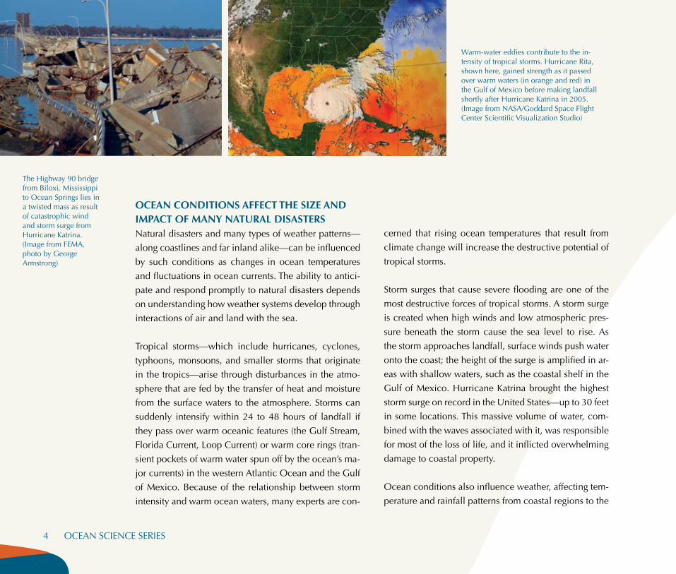
Warm-water eddies contribute to the in-tensity of tropical storms. Hurricane Rita, shown here, gained strength as it passed over warm waters (in orange and red) in the Gulf of Mexico before making landfall shortly after Hurricane Katrina in 2005. (Image from NASA/Goddard Space Flight Center Scientific Visualization Studio)
The Highway 90 bridge from Biloxi, Mississippi to Ocean Springs lies in a twisted mass as result of catastrophic wind and storm surge from Hurricane Katrina. (Image from FEMA, photo by George Armstrong)
4 OCEAN SCIENCE SERIES
cerned that rising ocean temperatures that result from
climate change will increase the destructive potential of
tropical storms.
Storm surges that cause severe flooding are one of the
most destructive forces of tropical storms. A storm surge
is created when high winds and low atmospheric pres-
sure beneath the storm cause the sea level to rise. As
the storm approaches landfall, surface winds push water
onto the coast; the height of the surge is amplified in ar-
eas with shallow waters, such as the coastal shelf in the
Gulf of Mexico. Hurricane Katrina brought the highest
storm surge on record in the United States—up to 30 feet
in some locations. This massive volume of water, com-
bined with the waves associated with it, was responsible
for most of the loss of life, and it inflicted overwhelming
damage to coastal property.
Ocean conditions also influence weather, affecting tem-
perature and rainfall patterns from coastal regions to the

interiors of the continents. An example is the El Niño,
a recurring weather pattern that has historically taken
place every three to seven years. In an El Niño, the nor-
mal upwelling of cold water along the Equator fails, and
warm tropical surface water spreads across the eastern
Pacific. These warm ocean waters contribute moisture
and heat to the atmosphere, bringing unusually warm,
wet weather to the west coasts of North and South Amer-
ica and influencing climate patterns globally. Strong El
Niño events have been associated with severe weather
patterns, from floods to droughts, worldwide and have
caused thousands of casualties, mainly from flooding
and outbreaks of disease.
Dealing with RapiD Changes in stoRm intensityHurricane Opal is a good example of just how quickly storm intensity can change. When the storm was first observed in early October 1995, it was a slow-moving cell that was drifting toward the Gulf of Mexico. In the middle of the night on October 3, however, the storm started one of the most rapid deepening and intensification cycles ever observed as it moved at 19 miles per hour toward the Gulf coast. Winds quickly increased to nearly 160 miles per hour as the storm progressed from a Category 1 storm to a Category 4 hurricane over a 20-hour period.
The storm approached Category 5 status within 12 hours of land-fall—not enough time to effectively alert the public. Fortunately, the storm weakened before reaching landfall, but storm-surge and wave activity caused much greater and more extensive damage along the coast than had been forecast originally.
Forecasting the intensity of storms can be difficult because critical questions about storm intensification, such as how warm ocean features like the Gulf Stream rapidly change the strength and impact of storms, are just beginning to be answered.
A band of warm water, shown here in red, causes a recurring weather pattern known as El Niño. These warm ocean waters bring unusually warm, wet weather to the west coasts of North and South America and influence climate patterns globally. (Im-age from NASA)
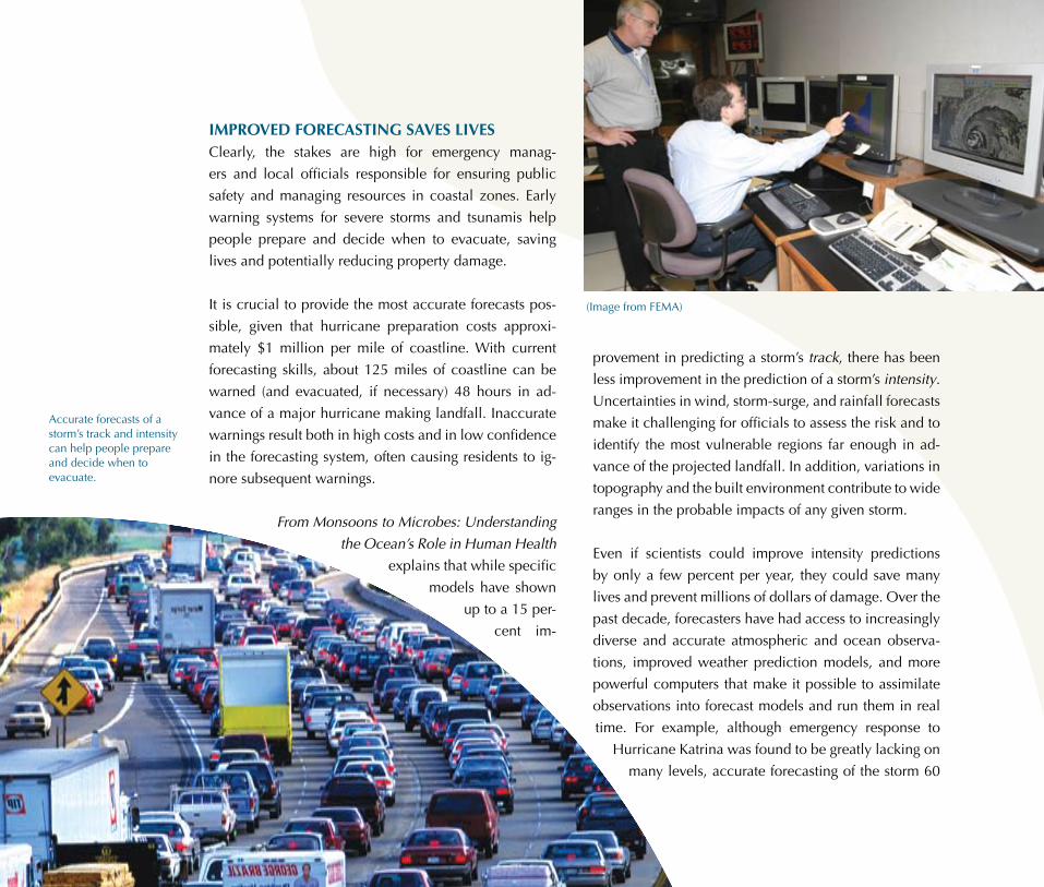
Accurate forecasts of a storm’s track and intensity can help people prepare and decide when to evacuate.
(Image from FEMA)
6 OCEAN SCIENCE SERIES
iMproved forecasting saves livesClearly, the stakes are high for emergency manag-
ers and local officials responsible for ensuring public
safety and managing resources in coastal zones. Early
warning systems for severe storms and tsunamis help
people prepare and decide when to evacuate, saving
lives and potentially reducing property damage.
It is crucial to provide the most accurate forecasts pos-
sible, given that hurricane preparation costs approxi-
mately $1 million per mile of coastline. With current
forecasting skills, about 125 miles of coastline can be
warned (and evacuated, if necessary) 48 hours in ad-
vance of a major hurricane making landfall. Inaccurate
warnings result both in high costs and in low confidence
in the forecasting system, often causing residents to ig-
nore subsequent warnings.
From Monsoons to Microbes: Understanding
the Ocean’s Role in Human Health
explains that while specific
models have shown
up to a 15 per-
cent im-
provement in predicting a storm’s track, there has been
less improvement in the prediction of a storm’s intensity.
Uncertainties in wind, storm-surge, and rainfall forecasts
make it challenging for officials to assess the risk and to
identify the most vulnerable regions far enough in ad-
vance of the projected landfall. In addition, variations in
topography and the built environment contribute to wide
ranges in the probable impacts of any given storm.
Even if scientists could improve intensity predictions
by only a few percent per year, they could save many
lives and prevent millions of dollars of damage. Over the
past decade, forecasters have had access to increasingly
diverse and accurate atmospheric and ocean observa-
tions, improved weather prediction models, and more
powerful computers that make it possible to assimilate
observations into forecast models and run them in real
time. For example, although emergency response to
Hurricane Katrina was found to be greatly lacking on
many levels, accurate forecasting of the storm 60

Information on ocean conditions is collected by a diverse network of sources. Observations are then assimilated through weather prediction models to inform forecasts. (Image courtesy of HARRIS Maritime Communications) Sources of weather data include:
• Automated coastal marine buoys • Commercial ships and military vessels • Oil and gas platforms • Tide and water level installations • The Doppler radar network • Automated commercial aircraft • Reconnaissance aircraft reports • Satellites
hours in advance of landfall made it possible for around
80 percent of the population to evacuate safely.
More data are needed for accrate forecastingWeather forecasts in the United States are produced
through a process that begins with the collection and
monitoring of several surface and upper-air observations
from around the globe. Data are collected from a diverse
network of sources, including automated coastal marine
buoys, commercial ships and military vessels, oil and gas
platforms, tide and water level installations, the Doppler
radar network, automated commercial aircraft, recon-
naissance aircraft reports, and satellites. Because storms
originate in the tropical ocean regions where few data are
available, the scientific community has also pioneered
mobile observing strategies in which drifting buoys are
released into the ocean during hurricane season to pro-
vide critical observations about the location and strength
of developing storms. All of these data sources and the
data they collect must be assimilated through global and
regional weather prediction models.
A network of coastal-marine and offshore moored buoys
operated by the National Oceanic and Atmospheric Ad-
ministration (NOAA) provides one source of real-time
data for weather prediction. This buoy system is used
along the U.S. coastlines to detect hazardous weather
before it strikes the shore. Buoys collect data under con-
ditions of weather too severe for human observers and
provide vital real-time information on wind, air and wa-
COASTAL HAZARDS 7

NOAA has deployed new state-of-the-art tsunami detection buoys to bolster tsunami warning and forecasting systems. (Image from NOAA)
ter temperature, air pressure, and waves. Public and pri-
vate weather forecasters can use the data generated by
these buoys to identify possible hazardous wind, sea-
state, and water-level conditions and to communicate
their findings to public safety officials, shipping com-
panies, fishing and recreational parties, and the general
public. Coastal weather forecasters at NOAA’s National
Weather Service rely extensively on the data provided
by the NOAA-operated buoy network.
The National Research Council report The Meteoro-
logical Buoy and Coastal Marine Automated Network
for the United States (1998) recommends that the buoy
The locations of active and planned tsunami detection buoys in NOAA’s DART system (as of March 2007). (Image from NOAA)
FRom waRnings to FoReCasts: impRoving tsunami DeteCtion systemsTsunamis occur when ocean waters are rapidly displaced on a massive scale, typically because of an earthquake. During a tsunami event, elevated ocean water forms massive waves that flood coastal areas when they reach the shore. The death and destruction that result from tsu-nami events can be catastrophic, such as the aftermath of the tsunami that hit Southeast Asia in December 2004 after an earthquake erupted beneath the Indian Ocean. Hundreds of thou-sands of people died and many more were left homeless. Coastal areas in the United States are also vulnerable to tsunamis, particularly in the Pacific Northwest, Hawaii, and Alaska, but the Caribbean and Atlantic coasts have also experienced tsunamis from both earthquakes and massive offshore landslides. The National Oceanic and Atmospheric Administration (NOAA) operates a Tsunami Program that addresses many aspects of tsunami preparedness, from hazard assessment to international coordination. In addition to operating several tsunami warning and information centers, NOAA has developed the Deep-ocean Assessment and Reporting of Tsunamis (DART) system, which consists of seafloor pressure sensors that can detect a tsunami as it passes and a commu-nication system to relay information to tsunami warning centers in real time. Science and technology development in tsunami predictability, such as the DART system, is critical to NOAA’s Tsunami Program. Increasingly accurate tsunami forecasts can be used to issue watches, warnings, or evacuations and can potentially save many lives.

coastal-marine observing system add more observing
platforms—especially in the storm-prone Atlantic Ocean
and Gulf of Mexico regions—to provide better support
for weather-forecasting operations. In the years since
that report was released, there have been significant
improvements in observing platforms and sensors col-
lecting weather and oceanographic data in the ocean.
The number of tsunami detection buoys has increased
from 6 basic systems to more than 30 state-of-the-art
systems, and there have been considerable increases in
the number of buoys and sensors collecting information
on hurricanes, climate change, and a variety of other
changes in the ocean environment, including sea level
rise, heavy seas, unusually high tides, and high sea sur-
face temperatures.
advances in forecasting require More than just advances in scienceMarked gains have also been made in obtaining real-
time weather and atmospheric observations, especially
from satellites. In addition, the National Science Foun-
dation, NOAA, the National Aeronautics and Space Ad-
ministration (NASA), and other agencies have developed
more accurate forecasting models that take advantage of
higher computing speed and capabilities to improve our
understanding of weather and climate patterns.
Unfortunately, weather and climate forecasting services
are under considerable stress just to meet daily demand.
The National Research Council report From Research to
Operations in Weather Satellites and Numerical Weath-
using ReseaRCh Data in weatheR pReDiCtion: the stoRy oF tRmmThe Tropical Rainfall Measuring Mission (TRMM) is an example of a satellite designed strictly for research that has turned into a valuable component of many different weather and climate related activities. Launched by NASA and the Japanese space agency in 1997, TRMM’s reliable sensors and high-quality measurements provide unique, near real-time data for many different agencies, including the Joint Typhoon Warning Center, the National Center for Environmental Prediction, and the National Hurricane Center. TRMM data have been used in determining hurricane centers and rainfall estimates for flood forecasts and warnings, as well as in routing aircraft across oceans to avoid storm cells. TRMM was never designed as a long-term mission— it only had enough fuel to power the satellite’s operations until 2006 while retaining enough energy for a controlled return to Earth. When NASA announced in 2004 its intention to end the mission, the weather research and operations community strongly objected. At NASA’s request, the National Research Council report Assessment of the Benefits of Extending the Tropical Rainfall Measuring System (2006) answered an important question: What are the scientific and operational benefits of using the remaining fuel to extend the mission? NASA had to weigh this advice against the safety risks of an uncontrolled reentry. Based on the benefits presented in the report, NASA decided to extend the mission. TRMM is expected to continue orbiting until about 2012-2013, or earlier if critical systems fail. NASA plans to launch the Global Precipitation Measurement mission (GPM) in 2013 to succeed TRMM.
Image from
NA
SA

er Prediction: Crossing the Valley of Death (2000)
found that there is a lack of resources to incorporate
and exploit new research results in day-to-day weath-
er operations. The nation will not benefit from the in-
vestment in research until current scientific advances
become part of the operational forecasting system.
For example, the United States has invested almost $1
billion in a national Doppler weather radar network as
part of the modernization of the weather service. At the
heart of the network is the NEXRAD radar that provides
critical information for severe weather warnings issued
by the National Weather Service. Although the radar
network has been working for several years, the de-
tailed data it provides—such as precipitation rate and
wind velocity—have not been assimilated into opera-
tional weather prediction. Part of the problem is the
lack of coordination among the many different gov-
ernment agencies that are involved in researching,
gathering data, and issuing forecasts. When these
agencies begin to work together, the results will
have far-reaching benefits.
Communicating impending risks to potentially
affected communities is also an essential part
of making the best use of advances in forecast-
ing. Encouraging people to evacuate or take
other measures to protect themselves and
their property from damage—and actually
getting people to heed storm warnings—is
critical to the effectiveness of weather-fore-
casting systems. The National Research Council report
Making Climate Forecasts Matter (1999) identified some
of the social and cultural aspects of effectively dissemi-
nating forecast information and concluded that more
research would help to improve information dissemina-
tion systems.
Shoreline erosion is a natural process caused by coastal
and ocean dynamics that constantly shape and change
the coast as sediment is deposited and lost. This process
is exacerbated by rises in the sea level, storms, and other
natural events. Shoreline erosion has been on the rise
in many areas during the past century. As populations
grow and more homes, roads, and businesses are built
near the coasts, buffer zones such as coastal forests and
wetlands are lost, thus making coastal areas more vul-
nerable to erosion and flooding. On the Atlantic coast,
the average erosion rate is about two to three feet per
year. The nation’s highest erosion rate—up to six feet per
year—occurs along the coasts of the Gulf of Mexico.
SHORELINE EROSION PUTS COASTAL POPULATIONS at risk
SHORELINE EROSION PUTS COASTAL POPULATIONS at risk
Bay region is experiencing a rise in sea level at twice
the rate of the world average due to the combination
of global sea level rise, local sinking of the land, and
wave erosion. The University of Maryland’s Laboratory
for Coastal Research found that at least 13 islands in the
Chesapeake Bay area have disappeared since the region
was first mapped by Europeans. Several more islands
may be inundated as the sea continues to rise.
reducing vulnerability will require tough societal decisionsThe Federal Emergency Management Agency (FEMA),
the government agency charged with leading the
response to natural disasters in the United States, esti-
mates that one-quarter of homes and other structures
within 500 feet of the United States’ coastlines will fall
victim to the effects of erosion over the next several de-
cades. FEMA is part of an ongoing debate on how to best
manage coastal erosion
and whether or how to
use the National Flood
Insurance Program to ad-
dress the problem. This
program, which is ad-
ministered by FEMA,
makes flood insurance
avaiable in return for lo-
cal governments taking
actions through building
codes and planning that
are intended to reduce
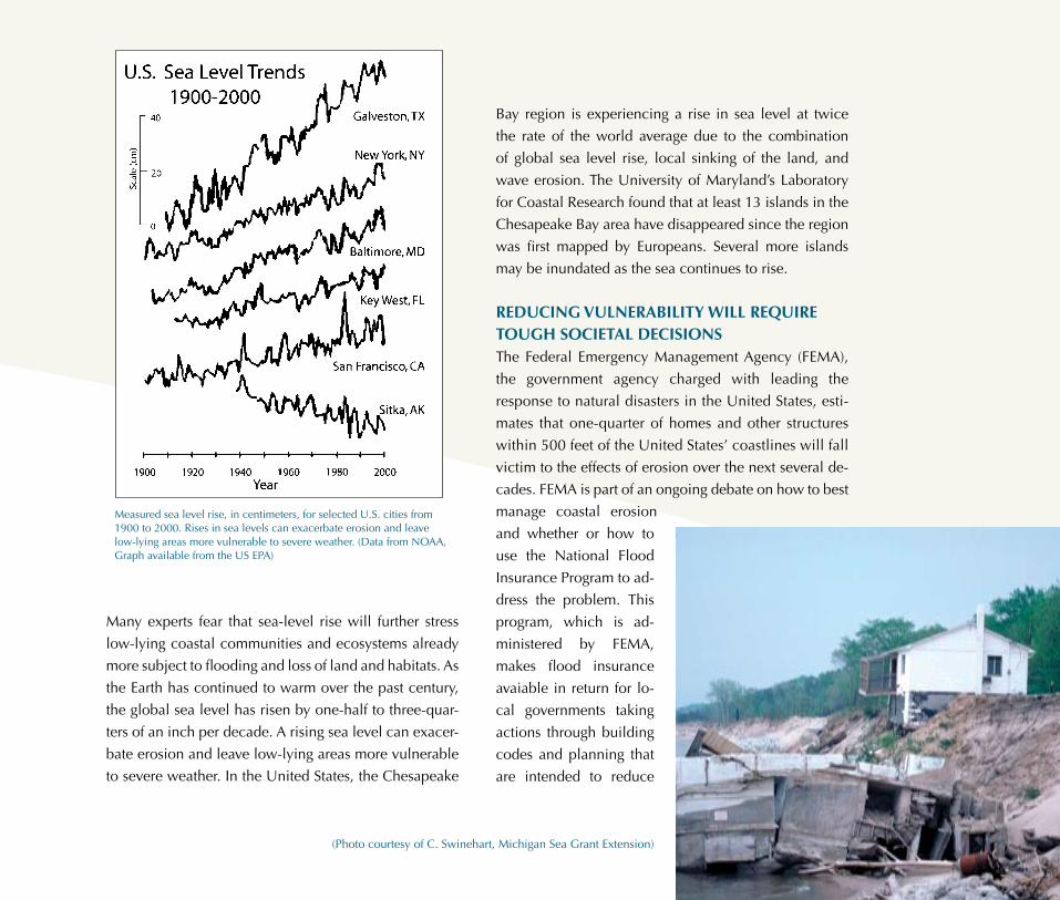
Measured sea level rise, in centimeters, for selected U.S. cities from 1900 to 2000. Rises in sea levels can exacerbate erosion and leave low-lying areas more vulnerable to severe weather. (Data from NOAA, Graph available from the US EPA)
Many experts fear that sea-level rise will further stress
low-lying coastal communities and ecosystems already
more subject to flooding and loss of land and habitats. As
the Earth has continued to warm over the past century,
the global sea level has risen by one-half to three-quar-
ters of an inch per decade. A rising sea level can exacer-
bate erosion and leave low-lying areas more vulnerable
to severe weather. In the United States, the Chesapeake
(Photo courtesy of C. Swinehart, Michigan Sea Grant Extension)
future costs of major
storm events. Those
local governments, how-
ever, have not vigorously
enforced these building codes.
Societal decisions related to coastal
building and restoration projects will only
become more difficult. The National Research
Council report Drawing Louisiana’s New Map: Address-
ing Land Loss in Coastal Louisiana (2006), which was
written before Hurricane Katrina struck, reviews plans to
restore the area’s catastrophic wetland loss, which was
recorded at 24 square miles per year from 1990 to 2000.
The report poses a very important central question:
How does Louisiana want its new coast to look? The
report recommends that a detailed map of the expected
future landscape of the Louisiana area be developed.
The map should be based on conscious decisions
that consider the distribution of natural and agricul-
tural resources, protection of infrastructure, and future
human habitation. For such a map to be meaningful, the
commitment of decision makers at all levels of govern-
ment—local, state, and federal—as well as the public
will be needed.
12 OCEAN SCIENCE SERIES
Hard barriers like this bulkhead are often used to pro-tect coastal prop-erty from land loss. (Photo courtesy Hugh Shipman)
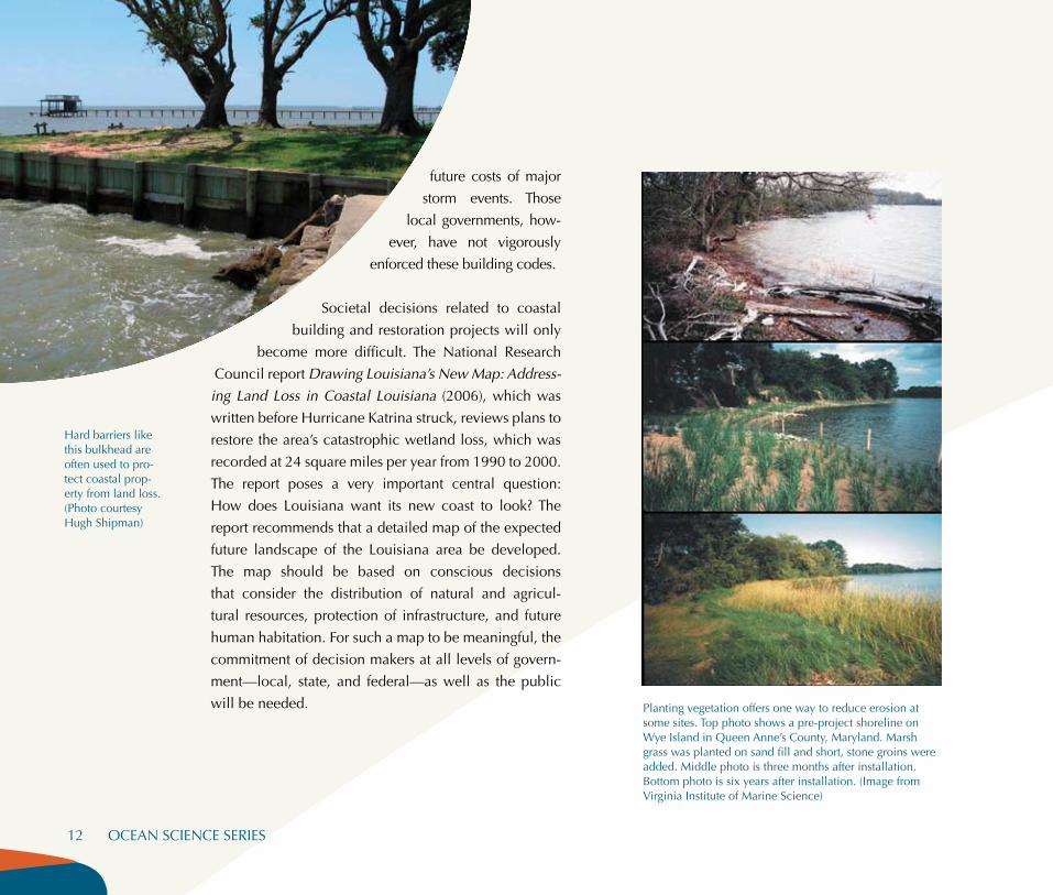
Planting vegetation offers one way to reduce erosion at some sites. Top photo shows a pre-project shoreline on Wye Island in Queen Anne’s County, Maryland. Marsh grass was planted on sand fill and short, stone groins were added. Middle photo is three months after installation. Bottom photo is six years after installation. (Image from Virginia Institute of Marine Science)

Mitigating shore erosion is coMplex and requires integrated ManageMent plansShore-protection structures, such as levees, seawalls,
jetties, and breakwaters, are recent attempts at protect-
ing the coast and preventing flooding. The structures are
intended to control the movement of sand and the posi-
tion of the shoreline. However, as described in the Na-
tional Research Council report Mitigating Shore Erosion
Along Sheltered Coasts (2007), what may prove to be
a temporary fix in one area could disrupt natural pro-
cesses and result in more erosion in a different coastal
area. Managers and decision makers must balance the
trade-offs between the protection of property, on the
one hand, and the potential loss of landscapes, public
access, recreational opportunities, and natural habitats
(with correspondingly reduced populations of fish and
other living marine resources that depend on these habi-
tats), on the other.
Mitigating Shore Erosion Along Sheltered Coasts ex-
amines the impacts of shoreline management on such
sheltered coastal environments as barrier islands along the
Atlantic seaboard, bays, and estuaries. These areas ex-
perience less intense waves than do open coasts, but
they are still greatly affected by erosion and high waters.
Typically, landowners adopt a “hold-the-line” strategy that
relies on a hard, barrier-type structure to prevent loss of
property and to protect buildings. But structures such as
seawalls and bulkheads may affect erosion patterns in
Case stuDy: Coastal louisianaCoastal Louisiana provides an example of the complex relationship between natural ocean processes and human development. Long before Hurricane Katrina struck, the area was suffering catastrophic land loss—as much as 39 square miles per year in the in the 1950s, ’60s, and ’70s due to a combination of natural and human causes.
Coastal Louisiana naturally experiences sinking, which adds to the effects of sea level rise and causes land loss. For thousands of years, however, the natural land degradation was balanced by new land built up by sediment from the Mississippi.
People began to control the Mississippi and its flooding during the 18th and 19th centuries, and in the 20th century the sediment load of the river was reduced, wetlands were drained for urban development, and canals were dredged for navigation and oil and gas extraction.Approximately 2,250 miles of levees were built to prevent flooding of populated and agri-cultural areas in Louisiana and to maintain navigation channels. However, these activities disrupted the natural dynamics and accelerated land loss in the region as the river levees channeled the Mississippi’s sediment load into the deep waters of the Gulf of Mexico.
The vulnerability of New Orleans to storm-surge flooding has increased as the landscape has degraded—ironically, in part, as a result of the attempts to protect the city from river flooding. Approaches to restoring the balance of land building to offset natural land loss in the 21st century must include managing the river for flood protection, navigation, and coastal restoration.
Image from U.S. Army Corps of Engineers
nearby areas through scouring at the edges of structures
or by disrupting the transport of sediment downstream.
These structures can also damage sensitive marine eco-
systems and natural habitats.
The report says that better information is needed in order
to develop integrated shoreline management plans that
identify the potential effects of structures on ecosystems
and erosion. In addition, it recommends that policies en-
courage methods that reduce habitat loss and enhance
natural habitats—such as constructing marsh fringes or
using vegetation to stabilize a bluff.
creating seaMless land-to-sea Maps will help scientists understand coastal threatsMany tactics have been developed to reduce the risks
associated with coastal hazards and erosion. One com-
mon approach involves enacting laws that
prohibit construction or develop-
ment activities in particularly vulnerable areas. Other
steps, such as elevating oceanfront homes to be above
estimated storm-surge levels or burying offshore cables
and pipelines, can also reduce the threat of disaster.
Efforts to reduce the impacts of coastal hazards will be
successful only if decision makers can accurately assess
the nature of the threat. So says the National Research
Council report A Geospatial Framework for the Coastal
Zone: National Needs for Mapping and Charting (2004).
Federal, state, and local agencies charged with manag-
ing the nation’s coasts need information presented on
maps and charts to be accurate. For example, in order to
understand marine hazards such as tsunamis, high-wave
Bayside homes in Bowleys Quarters, Maryland, were surrounded by water after Hurricane Isabel struck in 2003. In order to understand—
and anticipate—marine hazards such as high-wave flooding, coastal inundation, tsunamis, and storm surges, specialists must have precise land-to-shore depth and elevation data. (Image from FEMA, photo by Crystal Payton)

flooding, coastal inundation, and storm surges, special-
ists must have precise land-to-shore depth and eleva-
tion data. Although detailed onshore maps and offshore
charts exist, there are no standardized products—either
maps or charts—that integrate the two.
For most coastal zone management activities, which in-
clude navigation, resource management, beach main-
tenance, and public safety, the single biggest need is a
continuous high-resolution map of the Earth’s surface
that extends from the land through the shoreline and be-
neath the water. However, maps and charts of coastal
areas have historically been depictions of data collected
in either the land or the sea, and differences in scale,
resolution, mapping conventions, and reference data
(horizontal and vertical frames of reference for mapping)
prohibit combining them. The single biggest challenge is
to identify a vertical datum—in this case, a fixed point
against which to measure land height and sea level, both
of which change over time.
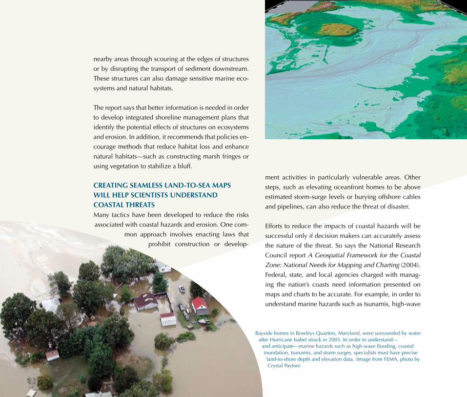
The Tampa Bay Bathy/Topo/Shoreline Demonstration Project—a joint effort of NOAA and the U.S. Geologi-cal Survey (USGS)—has developed a suite of tools that ultimately removes the problem of inconsistency between NOAA and USGS maps and charts while also providing a standard framework through which to incorporate other data. This project will allow detailed modeling of the effects of storm-surge or sea-level rise. (Image from the Center for Coastal and Ocean Map-ping, University of New Hampshire)
A Geospatial Frame-
work for the Coastal
Zone: National Needs
for Mapping and Charting
concludes that vertical da-
tum models must be developed
before an integrated onshore-off-
shore map can be created. To this
end, the report recommends creating a
series of real-time tidal measuring stations
and establishing a national project to develop
and apply new models, protocols, and tools. Fortu-
nately, steps are already being made toward this goal: a
seamless land-to-sea map of the coastal area is already
being developed on a small scale in Tampa Bay, Florida,
that ultimately removes the problem of inconsistency
between coastal maps from NOAA and land maps from
the U.S. Geological Survey (see figure at left).
COASTAL HAZARDS 15
CONCLUSIONAs coastal populations continue to grow, so too does
the need for better ways to increase the resilience of
coastal areas to the effects of severe weather, coastal
flooding and inundation, and erosion. Comprehen-
sive, cohesive policies on coastal protection need
to be based on the best possible information, from
improved coastal mapping to enhanced weather and
impact forecasting. Armed with knowledge gleaned
from these tools, government officials, coastal man-
agers, property owners, and everyone who enjoys the
nation’s coastal areas should work toward develop-
ing a long-term plan for ensuring that U.S. coastal
resources will be sustainable for future generations
to enjoy.

About the National AcademiesThe National Academies—the National Academy of Sciences, National Academy of Engineering, institute of Medicine, and the National research Council—provide a public service by working outside the framework of government to ensure independent advice on matters of science, technology, and medicine. They enlist committees of the nation’s top scientists, engineers, and other experts—all of whom volunteer their time to study specific concerns. The results of these deliberations are authoritative, peer-reviewed reports that have inspired some of the nation’s most significant efforts to improve the health, education, and wel-fare of the population.
This booklet was prepared by the National research Council based on the following reports:
Mitigating Shore Erosion Along Sheltered Coasts (2007) Sponsored by: U.S. Environmental Protection Agency, U.S. Army Corps of Engineers, Cooperative institute for Coastal and Estuarine Environmental Technology, NOAA Coastal Services Center.
Assessment of the Benefits of Extending the Tropical Rainfall Measuring Mission: A Perspective from the Research and Operations Community: Interim Report (2006) Sponsored by: National Aeronautics and Space Administration.
Drawing Louisiana’s New Map: Addressing Land Loss in Coastal Louisiana (2006) Sponsored by: State of Louisiana, U.S. Army Corps of Engineers.
A Geospatial Framework for the Coastal Zone: National Needs for Mapping and Charting (2004) Sponsored by: National Oceanic and Atmospheric Administration, Department of Commerce, U.S. Geological Survey, Department of the interior, U.S. Environmental Protection Agency.
From Research to Operations in Weather Satellites and Numerical Weather Prediction: Crossing the Valley of Death (2000) Sponsored by: National Aeronautics and Space Administration, National Oceanic and Atmospheric Administration.
Making Climate Forecasts Matter (1999) Sponsored by: National Oceanographic and Atmospheric Administration.
From Monsoons to Microbes: Understanding the Ocean’s Role in Human Health (1999) Sponsored by: National Oceanic and Atmospheric Administration, National institute of Environmental Health Sciences, National Aeronautics and Space Administration.
The Meteorological Buoy and Coastal Marine Automated Network for the United States (1998) Sponsored by: National Oceanic and Atmospheric Administration.
These and other reports are available from the National Academies Press, 500 Fifth Street, NW, Washington, DC 20001; 800-624-6242; http://www.nap.edu. reports are available online in a fully searchable format.
Cover photo courtesy of Win Henderson/FEMA.
For more information, contact the Ocean Studies Board at 202-334-2714 or visit http://dels.nas.edu/osb. Copyright 2007 by the National Academy of Sciences.
OC
EA
N S
CiE
NC
E S
Er
iES
in one way or another, every landform and creature on Earth reflects the pres-ence of the oceans. Understanding the Earth’s oceans is essential to our under-standing of human history, the origin of life, weather and climate, medicines, the health of the environment, energy sources, and much more. reports from the National Academies provide in-depth analysis and useful advice for poli-cymakers and the general public on topics ranging from exploring the ocean’s incredible biodiversity and resources to reducing threats to human safety from toxic algal blooms, contaminants, and coastal storms. This series is intended to help readers interpret information about the state of our oceans and better un-derstand the role of ocean science.
Other booklets in this series include Ocean Exploration, Marine Ecosystems and Fisheries, Oceans and Human Health, and Pollution in the Ocean.