Nuswantara’s Pyramid : Mount Lalakon · Mount Lalakon is located in Soreang, the capital of the...
18
Transcript of Nuswantara’s Pyramid : Mount Lalakon · Mount Lalakon is located in Soreang, the capital of the...


Mount Lalakon is located in Soreang, the capital of the Bandung Regency, West Java, although the locals living in the area refer to Lalakon as a mountain, at 986 meters above the sea level, it perhaps should be classified as a hill. What is most striking to the eye is that Lalakon is an oddly-shaped mound, with four almost clear-cut sloping sides, lending it a pyramidal appearance.
Mount Lalakon is situated 986 meters above the sea level.
| page01Nuswantara’s Pyramid : Mount Lalakon Turangga Seta | | www.lakubecik.org
Nuswantara’s Pyramid : Mount Lalakon
Hypothesis for the existence of a pyramid-like structure beneath Mount Lalakon, Soreang Bandung, West Java
Ayu Reditya, Danny Subrata and Maya Suara from the Turangga Seta with Mount Lalakon in the backgroundduring our first expedition on Dec, 29, 2010. The picture was taken at 12.06 pm local time
WETANTIMUR | EAST
KULONBARAT | WEST
LORUTARA | NORTH
KIDULSELATAN | SOUTH

| page02Nuswantara’s Pyramid : Mount Lalakon Turangga Seta | |
Nuswantara’s Pyramid : Mount Lalakon
www.lakubecik.org
Intrigued by the pyramid-like appearance of Lalakon, we set out to investigate further. During our climb up the hill, we encountered seemingly man-made “rungs” of approximately 2 x 2 meters in measurement. Moreover, the hill also has characteristic features that definitely place it in a class of its own:
1. Despite its location in the tropics, Lalakon does not support deep-rooted vegetation and yet its top soil has never been eroded by rain.
2. The hill’s soil composition consists of Tufa stone, breccias comprising hard, soft and breakable Andesite compounds.
3. The fact that it is impossible to dig or drill for a water well on and around Lalakon because of the existence of hard rock layer not far beneath the top soil. The area at the foot of the mountain also seems unnaturally level.
4. The area around Lalakon is notorious for interfering with GPS signal and is capable of scrambling directions on a compass.

| page03Nuswantara’s Pyramid : Mount Lalakon Turangga Seta | |
Nuswantara’s Pyramid : Mount Lalakon
www.lakubecik.org
Prompted by these unusual characteristics of the mountain, we proceeded with a geoelectric survey with SuperSting R8, dispersing 56 electrodes with 5 meter intervals.
LALAKON Inverted Resistivity Section Iteration = 0|
LALAKON Inverted Resistivity Section Iteration = 1|

| page04Nuswantara’s Pyramid : Mount Lalakon Turangga Seta | |
Nuswantara’s Pyramid : Mount Lalakon
www.lakubecik.org
LALAKON Inverted Resistivity Section Iteration = 2|
LALAKON Inverted Resistivity Section Iteration = 3|
LALAKON Inverted Resistivity Section Iteration = 4|

| page05Nuswantara’s Pyramid : Mount Lalakon Turangga Seta | |
Nuswantara’s Pyramid : Mount Lalakon
www.lakubecik.org
LALAKON Inverted Resistivity Section Iteration = 5|
LALAKON Inverted Resistivity Section Iteration = 6|
LALAKON Inverted Resistivity Section Iteration = 0|
Barat | West
Timur | East

| page06Nuswantara’s Pyramid : Mount Lalakon Turangga Seta | |
Nuswantara’s Pyramid : Mount Lalakon
www.lakubecik.org
As a follow-up to the survey, the Turangga Seta Foundation, consisting of teams of volunteers from Jakarta, Bandung, Bogor and Yogyakarta, conducted a preliminary excavation of the mountain. The three-day excavation was done with the full cooperation with and aid by the local villagers.
Excavation in progress at the top of Lalakon
March 14, 2011 | 15:17 | angle to view : Northwest - Southwestward
| page07Nuswantara’s Pyramid : Mount Lalakon Turangga Seta | |
Nuswantara’s Pyramid : Mount Lalakon
www.lakubecik.org
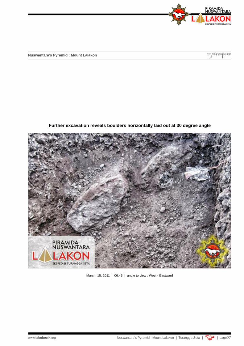
Further excavation reveals boulders horizontally laid out at 30 degree angle
March, 15, 2011 | 06.45 | angle to view : West - Eastward

| page08Nuswantara’s Pyramid : Mount Lalakon Turangga Seta | |
Nuswantara’s Pyramid : Mount Lalakon
www.lakubecik.org
March, 15, 2011 | 06.46 | angle to view : Southwest - Northeastward
Boulders at different angle

Nuswantara’s Pyramid : Mount Lalakon
| page09Nuswantara’s Pyramid : Mount Lalakon Turangga Seta | | www.lakubecik.org
March,15, 2011 | 07:59 | angle to view : East - Westward
Boulders are laid out to a discernable pattern

Nuswantara’s Pyramid : Mount Lalakon
| page10Nuswantara’s Pyramid : Mount Lalakon Turangga Seta | | www.lakubecik.org
Boulders with abutting pattern at the depth of 4.5 meters from the surfaceat a 30 degree angle
March, 15, 2011 | 15:54 | angle to view : West - Eastward

Nuswantara’s Pyramid : Mount Lalakon
| page11Nuswantara’s Pyramid : Mount Lalakon Turangga Seta | | www.lakubecik.org
Adjoining boulders from a different angle
March, 15, 2011 | 15:55 | angle to view : East - Westward

Nuswantara’s Pyramid : Mount Lalakon
| page12Nuswantara’s Pyramid : Mount Lalakon Turangga Seta | | www.lakubecik.org
Boulders after being cleansed of dirt and soil
March, 16, 2011 | 09:44 | angle to view : West - Eastward

Nuswantara’s Pyramid : Mount Lalakon
| page13Nuswantara’s Pyramid : Mount Lalakon Turangga Seta | | www.lakubecik.org
March, 16, 2011 | 09:46 | angle to view : Northeast - Southwestward
Cleansed boulders from a different angle

Nuswantara’s Pyramid : Mount Lalakon
| page14Nuswantara’s Pyramid : Mount Lalakon Turangga Seta | | www.lakubecik.org
From the results of the geoelectric survey and the preliminary excavation, we venture to suggest that there appears to be a pyramid-like hidden man-made structure hidden beneath the surface of Mount Lalakon. What is more, judging from the pattern in which the boulders are laid out, the structure would appear to have been buried on purpose.
The concealment the structure is formed by layers of natural materials from top to bottom, yet forming an unnatural pattern as follows :
At the depth of 1 to 1.6 meters from the top soil lies a layer of andesite boulders.
The first layer of boulders is followed by an approximately 20 centimeter layer of softer andesite compounds.
Then another layer of soft andesite is found.
- From the depth of 3.5 meters onward exists another layer of andesite boulders.
The boulders, on average 1 to 2 meters in length and 0.3 and 0.5 meters in thickness, seem to function as gabions to support the soil and other softer rocks from being eroded. The preliminary excavation also revealed that the boulders were greater in size as we dug deeper. From the extant field data and findings, we venture to project the silhouette of the hidden structure as follows :
-
-
- Next come aggregates of dirt and clay for another 20 centimeters.
-
Concealment pattern at Mount Lalakon side view
30°Projected pyramidal structure
: Boulders acting as gabions

Nuswantara’s Pyramid : Mount Lalakon
| page15Nuswantara’s Pyramid : Mount Lalakon Turangga Seta | | www.lakubecik.org
Pattern of gabion-boulderstop view
Approximate of the shape of the hidden structure and its basin, projected from reportsby local villagers in their past failed attempts to dig to drill for water wells
Mount Lalakon
Pyramidfloor
local villagers
well

Nuswantara’s Pyramid : Mount Lalakon
| page16Nuswantara’s Pyramid : Mount Lalakon Turangga Seta | | www.lakubecik.org
Turangga Seta team members from Jakarta, Bandung, Bogor and Yogyakartaat the summit of Lalakon
Standing Left to Right : Timmy Hartadi, Jimmy Pardede, Umi Lasmina, Sugiarto Hadiwinoto, Diah Laksmi, James Sadara, Ayu Reditya Dewi,Daniel Silaen, Reyhan Benatar Algadri
Seated Left to Right : Agung Bimo Sutejo, Maya Suara, Wahyu Santoso Hidayat, Danny Subrata
Turangga Seta team members that participated in the field survey and excavation at Lalakon :
Jakarta : Agung Bimo Sutejo, Wahyu Santoso Hidayat, Ayu Reditya Dewi, Diah Laksmi, Umi Lasmina, Reyhan Benatar Algadri
Bogor : Sugiarto Hadiwinoto, Daniel Silaen, Jimmy PardedeBandung : Danny Subrata, Maya SuaraYogyakarta : Timmy Hartadi, James Sadara, Cahyo Pinarak
Supporting teams :- Nita Triyana and Jaffi with Primetime’s team from Jakarta- Virza Roy Hizzal and friends from Indonesia Advocate Organization- Diggers of residents around Mount Lalakon

| page17Nuswantara’s Pyramid : Mount Lalakon Turangga Seta | |
Nuswantara’s Pyramid : Mount Lalakon
www.lakubecik.org
Raising the national flag on the final day of the excavation
Turangga Seta team members with the local authorities and residents who helped with the excavationMarch, 16, 2011
Thanks also to :All Ancestors for the blessing; Diggers of residents around Mount Lalakon; Lurah Badaraksa and the local authorities; Ketua RW 15; Bapak Akri - Ketua RT 2; Portirs; Agung Bolang and friends for the coffee and noodle :-); Indra Darmawan and Iwan Kurniawan; Bapak Engkon Kertapati from Pusat Survei Geologi Badan Geologi Departemen ESDM Bandung; Parents of Danny Subrata - Bandung; Romy Soekarno; Opang, Rina, Agus and all the Tuntunganers Yogyakarta; Anita Pramitha - Bandung; Johannes Nugroho Onggo Sanusi - TS Surabaya, Lutfi Kurniawan - TS New York; the wole big family of Turangga Seta Jakarta, Bandung, Bogor, Yogyakarta, Kediri, Surabaya, Bali and Makassar; all citizens and villagers around Mount Lalakon; all friends from Greget Nuswantara.
Suradira Jayaningrat, Swuh Kabrasta den Pangastuti, Jaya-Jaya Wijayanti ...Jayalah Nuswantara !
Compiled by : Agung Bimo Sutejo & Timmy HartadiTurangga Seta Foundation
March, 21, 2011
TURANGGA SETAJl. Ampera Raya No.2 Cilandak Timur Jakarta Selatan, Indonesia 12560e: [email protected], [email protected] [email protected], [email protected]