NPS Form 10-900 OMB No. 1024-0018 United States Department...
62
NPS Form 10-900 OMB No. 1024-0018 1 United States Department of the Interior National Park Service National Register of Historic Places Registration Form This form is for use in nominating or requesting determinations for individual properties and districts. See instructions in National Register Bulletin, How to Complete the National Register of Historic Places Registration Form. If any item does not apply to the property being documented, enter "N/A" for "not applicable." For functions, architectural classification, materials, and areas of significance, enter only categories and subcategories from the instructions. 1. Name of Property Historic name: __Vulcan Mine Historic District____________________________________ Other names/site number: _CA-SBR-03065_____________________________________ Name of related multiple property listing: __N/A_________________________________________________________ (Enter "N/A" if property is not part of a multiple property listing ____________________________________________________________________________ 2. Location Street & number: __5.28 miles east of Kelbaker Road, on Vulcan Mine Road_____________ City or town: __Kelso________ State: _California___ County: _San Bernardino_______ Not For Publication: Vicinity: ____________________________________________________________________________ 3. State/Federal Agency Certification As the designated authority under the National Historic Preservation Act, as amended, I hereby certify that this nomination ___ request for determination of eligibility meets the documentation standards for registering properties in the National Register of Historic Places and meets the procedural and professional requirements set forth in 36 CFR Part 60. In my opinion, the property ___ meets ___ does not meet the National Register Criteria. I recommend that this property be considered significant at the following level(s) of significance: ___national ___statewide ___local Applicable National Register Criteria: ___A ___B ___C ___D Signature of certifying official/Title: Date ______________________________________________ State or Federal agency/bureau or Tribal Government In my opinion, the property meets does not meet the National Register criteria. Signature of commenting official: Date Title : State or Federal agency/bureau or Tribal Government X
Transcript of NPS Form 10-900 OMB No. 1024-0018 United States Department...

NPS Form 10-900 OMB No. 1024-0018
1
United States Department of the Interior National Park Service
National Register of Historic Places Registration Form This form is for use in nominating or requesting determinations for individual properties and districts. See instructions in National Register Bulletin, How to Complete the National Register of Historic Places Registration Form. If any item does not apply to the property being documented, enter "N/A" for "not applicable." For functions, architectural classification, materials, and areas of significance, enter only categories and subcategories from the instructions.
1. Name of Property Historic name: __Vulcan Mine Historic District____________________________________ Other names/site number: _CA-SBR-03065_____________________________________
Name of related multiple property listing: __N/A_________________________________________________________ (Enter "N/A" if property is not part of a multiple property listing ____________________________________________________________________________
2. Location Street & number: __5.28 miles east of Kelbaker Road, on Vulcan Mine Road_____________ City or town: __Kelso________ State: _California___ County: _San Bernardino_______ Not For Publication: Vicinity:
____________________________________________________________________________ 3. State/Federal Agency Certification As the designated authority under the National Historic Preservation Act, as amended, I hereby certify that this nomination ___ request for determination of eligibility meets the documentation standards for registering properties in the National Register of Historic Places and meets the procedural and professional requirements set forth in 36 CFR Part 60. In my opinion, the property ___ meets ___ does not meet the National Register Criteria. I recommend that this property be considered significant at the following level(s) of significance: ___national ___statewide ___local
Applicable National Register Criteria: ___A ___B ___C ___D
Signature of certifying official/Title: Date ______________________________________________ State or Federal agency/bureau or Tribal Government
In my opinion, the property meets does not meet the National Register criteria.
Signature of commenting official: Date
Title : State or Federal agency/bureau or Tribal Government
X
acrain
Draft

United States Department of the Interior National Park Service / National Register of Historic Places Registration Form NPS Form 10-900 OMB No. 1024-0018 Vulcan Mine Historic District San Bernardino, CA Name of Property County and State
Sections 1-6 page 2
______________________________________________________________________________
4. National Park Service Certification I hereby certify that this property is: entered in the National Register determined eligible for the National Register determined not eligible for the National Register removed from the National Register other (explain:) _____________________
______________________________________________________________________ Signature of the Keeper Date of Action
____________________________________________________________________________ 5. Classification
Ownership of Property (Check as many boxes as apply.)
Private:
Public – Local
Public – State
Public – Federal
Category of Property (Check only one box.)
Building(s)
District
Site
Structure
Object
X
X
X
X

United States Department of the Interior National Park Service / National Register of Historic Places Registration Form NPS Form 10-900 OMB No. 1024-0018 Vulcan Mine Historic District San Bernardino, CA Name of Property County and State
Sections 1-6 page 3
Number of Resources within Property (Do not include previously listed resources in the count)
Contributing Noncontributing _____________ _____________ buildings ______2______ _____________ sites ______5______ ______2______ structures _____________ _____________ objects ______7_______ ______2________ Total
Number of contributing resources previously listed in the National Register ____0____ ____________________________________________________________________________
6. Function or Use Historic Functions (Enter categories from instructions.)
DOMESTIC: institutional housing DOMESTIC: secondary structure DOMESTIC: camp____ TRANSPORTATION: road-related (vehicular) INDUSTRY/PROCESSING/EXTRACTION: processing site ___________________ ___________________
Current Functions (Enter categories from instructions.)
LANDSCAPE: park___ RECREATION AND CULTURE: outdoor recreation VACANT/NOT IN USE ___________________ ___________________ ___________________

United States Department of the Interior National Park Service / National Register of Historic Places Registration Form NPS Form 10-900 OMB No. 1024-0018 Vulcan Mine Historic District San Bernardino, CA Name of Property County and State
Section 7 page 4
_____________________________________________________________________________ 7. Description
Architectural Classification (Enter categories from instructions.) NO STYLE_________ ___________________ ___________________ ___________________ ___________________ ___________________ ___________________
Materials: (enter categories from instructions.) Principal exterior materials of the property: __Foundation: earth, concrete, asphalt;
Walls: concrete; Roof: concrete____________
Narrative Description (Describe the historic and current physical appearance and condition of the property. Describe contributing and noncontributing resources if applicable. Begin with a summary paragraph that briefly describes the general characteristics of the property, such as its location, type, style, method of construction, setting, size, and significant features. Indicate whether the property has historic integrity.) ______________________________________________________________________________ Summary Paragraph The Vulcan Mine Historic District is located in the vicinity of 7,162-foot Edgar Peak high in the Providence Mountains in eastern San Bernardino County. The district is primarily within the boundaries of (and managed by) Mojave National Preserve, a unit of the National Park Service, with additional property under private and State ownership. The 437-acre district sits at the base of steep cliffs and peaks, at the top of Foshay Pass overlooking Kelso Wash to the west. The district is stretched between the defunct Vulcan Mine, one of the great iron mines of the twentieth century, on the east, to the historic Kelso Depot and loading ramp area of the Vulcan Mine to the west. Generally, the Vulcan Mine Historic District is comprised of the main mining complex where ore was extracted from an open pit, a transportation corridor that connects it to Kelso, and the loading ramps at Kelso used to transfer the iron ore to railcars. The mining complex includes the large open pit, waste rock pile, associated operational and residential areas, and a system of roads and terraces. The 9-mile Vulcan Mine-Kelbaker Road originally constructed by Kaiser Steel still follows its original alignment and connects to the historic, earthen loading ramps at Kelso. Because of the temporary nature of mining in the district, mining features were not intended to outlast the brief spurt of mining activity that occurred from 1942 to 1947. All of the buildings were removed in 1949 when mining operations ceased, leaving only

United States Department of the Interior National Park Service / National Register of Historic Places Registration Form NPS Form 10-900 OMB No. 1024-0018 Vulcan Mine Historic District San Bernardino, CA Name of Property County and State
Section 7 page 5
foundations and footings to mark their former locations. Some roads and other features located in washes have been disturbed by storm events. However, most features, such as the open pit, waste rock pile, foundations and footings, main roads, and the loading ramps are stable. The Vulcan Mine Historic District appears much as it did during the period of significance and retains its historical integrity of location, design, setting, materials, workmanship, feeling and association. ______________________________________________________________________________ Narrative Description Contributing resources include the residential area foundations and footings, crusher plant foundations, cap and fuse house, magazine storage structure, Kelso loading ramps, Vulcan Mine Road, and the mining complex circulation network. The historic character of the Vulcan Mine Historic District is still evident in the following landscape characteristics: natural systems and features, spatial organization, topography, circulation, buildings and structures, and archeological sites. Based on the evaluation of these characteristics, the cultural landscape at Vulcan Mine was found to exhibit key patterns, relationships, and features that convey the historical significance of the district. Vulcan Mine Historic District is at an elevation of about 3,900 feet in the south central portion of the Providence Mountains in Foshay Pass, within Mojave National Preserve in eastern San Bernardino County. A federally designated wilderness area boundary is immediately adjacent to the mine with some state as well as privately owned properties in the vicinity described more fully in the Boundary Description. The combined Mitchell Caverns State Natural Preserve/Providence Mountains State Recreation Area is 3.5 miles northeast of the mine. There are no towns of significant size within 60 miles of the district. Settlements of Essex, Fenner, and Goffs (towns on this section of the Southern Pacific Railroad were named alphabetically) are fading outposts on old Route 66. Needles (population 4,844) is 67 miles by road, and Barstow (population 22,639) is 128 miles from the district. San Bernardino, the county seat, is 204 miles away by road. Setting, Geology, and Vegetation Overview Mojave National Preserve is located in southeastern California in the Mojave Desert. The district is located in the southwestern quadrant of the preserve, where vegetation is sparse and low growing. Cacti and thorny shrubs are conspicuous, and many thornless shrubs and herbs are also present. Eons of erosion by wind and brief, but powerful, seasonal rains have significantly influenced the natural landscape as well as mining development. The site of the Vulcan Mine overlooks a vast basin that includes the historic Kelso Depot, Kelso Dunes, Devil’s Playground, Kelso Mountains, and Marl Mountains. The mine site sits in Foshay Pass, the passageway of Friar Francisco Garces in 1776 when investigating an overland route between Spain’s interests in the Sonoran Region of Northern Mexico and the Spanish capital of Alta California at Monterey.
United States Department of the Interior National Park Service / National Register of Historic Places Registration Form NPS Form 10-900 OMB No. 1024-0018 Vulcan Mine Historic District San Bernardino, CA Name of Property County and State
Section 7 page 6
The geology of the area led to the Vulcan Mine becoming the primary source of iron ore during World War II on the west coast. In 1948, Charles Severy of the U.S. Bureau of Mines described the geology of the area in his report Mining Methods at the Vulcan Iron Mine. “Geologically, this region is composed of three main rocks: sedimentary deposits, which have since been more or less metamorphic; intrusions of acid igneous rocks; and later intrusions and flows of rhyolites” (Severy, p. 4). He continued to describe the iron deposit at Vulcan Mine as an “irregular, mushroom-shaped replacement of limestone by magnetite and hematite along a fault contact with a quartz monzonite.” (Severy, p. 4). The oval-shaped ore body is about 700 feet long by 325 feet wide, striking east-west, occupying two hillsides that are split by a dry wash. The larger portion of the ore body is on the eastern slope. No other mines in the Providence Mountains were known for iron as abundant as Vulcan Mine. Prior to the patent of the Vulcan claim, the area was known for its major mining operations: Bonanza King and Silver King mines, north of Vulcan Mine. The Mojave Desert is comprised of predominantly low, sparse vegetation adapted to the harsh desert environment. Due in part to a range in elevation from below sea level (in Death Valley) to 3,500 feet (1,350 meters), native plant communities of the Mojave Desert contain a mixture of species from the lower Colorado and higher Great Basin vegetation communities. The two primary vegetation communities, as identified in the 2006 Mojave National Preserve park brochure, are Creosote Bush Scrub and Cactus-Yucca Scrub. The Creosote Bush Scrub habitat and vegetation community consists primarily of the strong-scented creosote bush (Larrea tridentate) and bursage (Ambrosia dumosa). As explained in the park brochure, “creosote bushes are said to be the world’s oldest living things; some colonies in the Mojave Desert are 11,500 years old.” Other species found in this zone include brittlebush (Encilia farinose), desert mallow (Sphaeralcea ambigua), hedgehog cactus (Echinocereus triglochidiatus), and various types of cholla (Cylindropuntia spp.). The Cactus-Yucca Scrub community includes several species of cacti, including the prominent barrel cactus (Genus ferocactus) and the Mojave yucca (yucca schidigera). Other vegetation common to the district include turpentine broom (Thamnosma montana), desert mistletoe (Phoradendron californicum), Mojave indian paintbrish (Castilleja plagiotoma), Fremonts dalea (psorothamnus fremontii), and Burrobrush (Hymenoclea salsola). Many of these hardy plants bloom with brilliant color in the spring and then fade into dry silver and sage hues during the summer. During the period of significance, the lack of trees made road building an easier prospect, and meant a limited local supply of wood for building materials, which had to be brought in from long distances. The species and character of the vegetation provided an open landscape that remains. Over time, vegetation has continued to encroach on the historic roads that are no longer maintained or frequently used. Vegetation is also growing out of cracks in the concrete foundations at the residential and operational building areas, causing some damage to these features.

United States Department of the Interior National Park Service / National Register of Historic Places Registration Form NPS Form 10-900 OMB No. 1024-0018 Vulcan Mine Historic District San Bernardino, CA Name of Property County and State
Section 7 page 7
Spatial Organization Spatial organization is the three-dimensional organization of physical forms and visual associations in the landscape. The Vulcan Mine Historic District retains features that reflect the historic organization of the highly successful mining operation during the historic period from 1942 to 1947. Aspects of its organization reflect the process of open pit mining and how this activity shaped the landscape. The Vulcan Mine-Kelso Road still connects the industrial and residential areas at the mine complex to the Kelso loading ramps where the ore was loaded onto to rail cars to be transported to Fontana, California. The mine complex, located nine miles southeast of Kelso, contains the largest concentration of features associated with the historic mining activity at the Vulcan Mine Historic District. The complex is centered on the large open pit, waste rock pile, and adjacent building areas. The two distinct areas where buildings and structures once stood are the residential area and the operational area, both of which are sited on more level land adjacent to the roads, pit and waste rock pile, responding to the existing topography. Graded roads and walkways connect the building areas with one another and the mining activity. The residential area is located southwest of the pit, just below the waste rock pile in a level, graded area north of the Vulcan Mine Road. The buildings and structures were associated with habitation activity of those who worked at the mine. Buildings and structures that were constructed in this area during the period of significance were two dormitories, cooks dormitory, mess hall, superintendent’s cottage, two sheds/equipment structures, thirteen tent frames, and two tanks. Foundations from a water tank, superintendent’s cottage, and cooks dormitory, and the large graded area where the two dormitories and mess hall once stood remain. South of the open pit is an extensive array of concrete foundations and footings associated with the operational area. In the northern portion of the operational area, closest to the open pit, is the base of the crusher plant that stood on the hillside and traces of a looped access road used for loading trucks. The extracted ore was placed directly onto a conveyor belt at the top of the hillside, which moved the rock into the crusher plant and then down into the trucks. The presence of debris from the crusher plant along with the foundations provides a sense of the activities that took place in the 1940s. In addition to the crusher plant structure are a cluster of foundations on a level terrace south of the slope. Historically, this area had a warehouse, garage, machine shop, administrative building, powerhouse with three buildings, and two storage structures. This area retains the foundations of every building or structure except the smallest shed that was located behind the warehouse, reflecting the efficient use of level land below the hills and above the wash. The Vulcan Mine Road, loading access road, and the open pit access roads all intersect in this area.

United States Department of the Interior National Park Service / National Register of Historic Places Registration Form NPS Form 10-900 OMB No. 1024-0018 Vulcan Mine Historic District San Bernardino, CA Name of Property County and State
Section 7 page 8
Topography Topography is the three dimensional configuration of the landscape surface characterized by features and orientation. Topography, as discussed here, is limited to the manipulation of the landscape by human action. The activities associated with mining, such as excavation and road system development, significantly altered the topography of the Vulcan Mine Historic District landscape. While the greatest human manipulation of the earth took place at the mine complex, the development of the earthen Kelso loading ramps cannot be discounted. At the mine, material was removed from the hillside to extract the ore, creating a large deep pit, while the waste material was relocated nearby, filling in the adjacent valley. Additional topographic manipulation included tunnels that were created in search of the extent of the iron ore vein during the period of significance. These underground passages are typically not visible above ground except for drill holes and entrances to shafts and adits, and are often difficult to locate. Topography and circulation are very much intertwined at Vulcan Mine when it comes to early development of the pit. The benches surrounding the pit were created as material was excavated and used as slope stabilization structures as well as roads to remove material from the pit. Likewise, roads were created at the waste rock pile as access points for depositing the unwanted material. Circulation Circulation comprises the spaces, features, and applied material finishes which constitute systems of movement in a landscape. The interconnections between the open pit, waste rock pile, mine adits, crushing plant, operational and residential areas, and railroad are still evident. A number of roads were continuously altered throughout the period of significance as the result of topographic alterations through the mining process of removing and relocating materials. While some of the resulting roads serve as circulation routes, they are best described in context as topographic features. In nearly all situations, roads and walkways were the same during the period of significance. Major roads were generally placed on level land between washes, though there is evidence of roads passing through washes in some locations. The majority of the roads in the district are largely intact, despite occasional washouts out from seasonal flood events. Many of the roads and corresponding utility yards of the historic district continue to maintain their alignment, design, and materials, reflecting the character from the period of significance. Cap and Fuse Locker Foundation Magazine Storage Structure Foundation (Two Contributing Structures) Two foundations are located toward the eastern end of the Vulcan Mine Road, east of the pit. These foundations mark the locations of the cap and fuse locker and the magazine storage structure. Both were sited to make use of the topography and are built into the hillside with only short access roads off the main road. They were likely located further away from the mining activity to ensure safety of the explosive materials they housed.

United States Department of the Interior National Park Service / National Register of Historic Places Registration Form NPS Form 10-900 OMB No. 1024-0018 Vulcan Mine Historic District San Bernardino, CA Name of Property County and State
Section 7 page 9
The close proximity of the mine complex to the nearby town of Kelso is potentially one of the major factors in the mine’s success. With a location just nine miles southeast of Kelso, it was easy to transport iron ore to the railroad line heading west to the steel plant in Fontana. In addition to its proximity to Kelso, the historic district was also located in a highly accessible area of the Providence Mountain Range at the base of the western foothills in a relatively wide alluvial valley. The short distance and gentle grade of the lower canyon allowed for ease in transporting the ore away from the mine complex as well as bringing in the large machinery, equipment, and staff to run the mine. During the period of significance, a single road used for transporting people, ore, and equipment was aligned between Kelso and the mine complex following a portion of the road later known as Kelbaker Road in addition to the Vulcan Mine Road. Ramps for loading ore into the rail cars were located just south of the railroad track at Kelso, west of Kelbaker Road and north of the Vulcan Mine Road. Two spur tracks ran from the main line south to the ramps. The organization of this transport system is still evident through the earthen loading ramps, railroad tracks, and ramp access roads. Mining Complex Circulation Network (Contributing Structure) Within the mining complex, a system of roads was established for a number of utilitarian and industrial purposes associated with the mining operation. Land within the operational and residential areas were completely leveled and graded prior to the construction of the buildings. Roads were loosely defined through use, and often not paved. Areas were generally open allowing vehicles to drive anywhere. Utility yards served as circulation routes for both vehicles and pedestrians. Likewise, an open, leveled area below the crusher plant was also graded, providing an access road for the dump trucks to be filled and then head out to the railroad at Kelso. Constructing this loading access road required significant cutting of the hillsides northeast of the operational area to allow the trucks to get close enough to the conveyor belt that deposited the ore into the truck bed. Photos from the early 1940s show the loading access road as unpaved. Fieldwork in 2010 indicated the access road was paved with asphalt at some point. The utility yard at the residential area continues to exist as a flat, open expanse of land. Vegetation has begun to encroach. The primary vehicular routes through the utility yard continue to be used by park visitors and staff, maintaining much of the original alignments. The utility yard surrounding the operational area has filled in significantly with vegetation. A single road encircles the cluster and two small roads connect within. The roads are heavily defined through use, with vegetation and foundations defining the borders. The loading access road below the crusher plant has almost completely filled in with creosote plants, and traces of the asphalt alignment and graded area are still visible. This road is no longer used and is barely visible in aerial photography. A road developed as access to the waste rock pile begins as a spur off of the end of Vulcan Mine Road, just before the operational area. It switchbacks up and over the south-facing hillside of the small ridge southeast of the open pit, travelling northwest up the large valley

United States Department of the Interior National Park Service / National Register of Historic Places Registration Form NPS Form 10-900 OMB No. 1024-0018 Vulcan Mine Historic District San Bernardino, CA Name of Property County and State
Section 7 page 10
below Fountain Peak to a fork leading north or south. The northern fork travels up the adjacent hillside, turning southwest along the top of a small ridge overlooking the open pit and waste rock pile. The southern fork travels up the hillside north of the open pit, turning north along the top of the ridge and then curving southeast around the small peak that towers over the Vulcan Mine site. The road switchbacks up the northern side of the peak, terminating at around 4500 feet, just below a ridge. The purpose of these roads is unknown. It is possible that this road provides access to trenches or prospects that were developed to determine the extent of the iron vein. Because it was also one of the primary roads accessing the waste rock pile, it most likely changed significantly over time as the waste rock pile grew. These roads are no longer maintained or accessible to vehicles, and are commonly used as hiking trails. Open Pit Iron Mine The 1948 Severy report best describes the pit as stadium-shaped with an opening at the top that measures 1000 feet long and 600 feet wide with six benches cut into the steep walls to maintain a pit wall slope of ½:1 (Severy, p. 8). The oblong pit runs at a northwest/southeast angle, bisecting a small ridge that runs perpendicular to the lower flanks of the 4600-foot tall peak to the east where the highest ore outcrop reached 4060 feet in elevation. Development of the pit obstructed a wash that once lay between the ridge and peak. It is unclear how the runoff was directed during the period of active mining within the pit, though it now flows from the wash into the pit where water is present year round. It appears as though the northwestern portion of the pit and the waste rock pile are also located where another wash once flowed through. The wash now flows in a narrow valley between the waste rock mound and a taller ridge to the north. Open pit mining generally uses the bench-mining approach, as found at Vulcan Mine. A series of terraces, called benches, were cut into the hillside in order to extract the ore from the walls of the pit. The benches were also used as roads to transport the ore to the crusher plant or the overburden to the waste rock pile. Some benches were abandoned as the pit was dug deeper and the ore was more abundant elsewhere in the pit. The lowest bench, the bottom of the pit, is at the 3790-foot level. According to the 1948 Severy report, the plan was to open one more bench further down to the 3750-foot level, but it appears as though this final cut was never made since mining within the pit ceased prior to the publication of the report (Severy, p. 8). Benches are still evident within the pit, although some are inaccessible due to rockfalls. A large bench surrounds the top of the pit at the 4000-foot level on the northeast, northwest, and southeast sides, serving historically as an access road to the benches below and later as a hiking trail with views into the pit. It is difficult to differentiate where this bench ends and the roads accessing the waste rock pile, crusher plant and lower pit begin, as they appear to be a seamless series of interconnected roads since used as trails. Waste Rock Pile Between the residential area and the open pit is the waste rock pile. The overwhelming mass of dirt and rock removed during mining was of no value to the mine operators and was most easily relocated to an area in close proximity to the pit at a lower elevation to allow for piling. The pile is approximately 800 feet long and 400 feet wide at its widest point, rising 20 to 40 feet above

United States Department of the Interior National Park Service / National Register of Historic Places Registration Form NPS Form 10-900 OMB No. 1024-0018 Vulcan Mine Historic District San Bernardino, CA Name of Property County and State
Section 7 page 11
the valley floor near the pit and nearly 70 feet in elevation above the residential building area to the west. The waste rock pile was terraced, similar to the benches in the pit, to provide access routes to and from the pile. The natural slope of the debris material around the waste rock pile perimeter and at the terraces varies with the surrounding terrain. The top layer of the waste rock pile is flat, with portions of the terraces and top used as roads to access the dumping areas. The main leveled portion of the waste pile is around 3945 feet in elevation. The southwest portion of the waste pile includes a series of two terraces between the leveled top and the graded residential area. There is roughly 20-30 feet of elevation gain between each of the levels. It is unclear as to the exact amount of earth that was relocated to the waste pile. The 1948 report indicates that the amount of waste to the amount of ore removed was rather significant, such that the 2,500,000 tons of remaining ore below the bottom of the pit will most likely never be mined due to “the excessive amount of waste to be moved in order to enlarge the pit for deeper mining” (Severy, p. 7). The historic displacement of material from the open pit to the valley significantly altered the topography, hydrology, and character of the area. The slopes created where waste rock is piled leave a very geometric and linear pattern on the landscape that stands out from the organic curving of the natural hillsides and valleys that surround the waste rock pile. When compared to photos from the 1940s, the portions of the site that were filled in are still highly discernable, despite the lines having softened with erosion over the years. Because the waste rock pile was created over half a century ago, vegetation has established and visible erosion similar to that of the native hillsides is evident, and continues to stand out from the natural topography of the area. Indicators of the manipulated topography include the leveled top of the mound, the sorted fine dirt and large rock material, the lighter colored dirt and rock in contrast with surrounding soils, and the distinct terraces. Southwest of the large pit is a low-grade stockpile. With a similar topographic appearance to the waste rock pile, the stockpile serves as a storage area for lower quality ore and measures around 550-feet by 250-feet at the widest of the wedge-shaped pile. The stockpile sits just above the road that accesses the waste rock pile and western side of the large pit 40 feet in elevation above the main Vulcan Mine Road. The pile is easily identifiable in aerial photos because the black colored ore stands out from the surrounding lighter colored dirt and gravel. Adits and Drill Holes Typically, drill holes, shafts and adits provided knowledge of the location of ore, and reflected the exploitive phase of mining. Drill holes are narrow holes drilled into rock to determine the extent of an ore body. Shafts are vertically or steeply inclined openings, while adits are horizontally inclined openings that provided access to the ore. According to the 1948 Severy report, “exploration consisted of 482 feet of adits and 49 diamond-drill holes having depths 18 to 897 feet and totaling 11,672 feet (Severy, p. 2). It appears as though no shafts were drilled during the period of significance, but were used in the area for exploration in the early 1900s (see Physical History). No adits, shafts, or drill holes were located by Cultural Landscape Inventory (CLI) staff in 2010. Some adits and drill holes were mapped in the 1948 report, helping to indicate the extent of the ore body. Many of the original adits were located where the pit is and

United States Department of the Interior National Park Service / National Register of Historic Places Registration Form NPS Form 10-900 OMB No. 1024-0018 Vulcan Mine Historic District San Bernardino, CA Name of Property County and State
Section 7 page 12
were subsequently removed during excavation of the pit. It is also likely that some adits been plugged or filled in with debris over the years. It appears that the Magazine Storage structure at the end of the Vulcan Mine Road, east of the operational building area, is a former adit that was converted to storage. The key indicator of this possibility is in the construction, venting, and design, analogous to adit construction. It was likely constructed prior to the period of significance and incorporated in the Kaiser operation for storage. Residential and Operational Areas (Two Contributing Sites) Southwest of the waste rock pile and south of the pit are several level graded areas used for residential and operational purposes. The terrain near the open pit tends to be rough, rocky, and uneven and as such was unsuitable for working, living, and the construction of buildings and structures. As a result, rock removal, vegetation removal, and grading were necessary to create flat level areas amenable for the placement of roads, buildings, and structures. Many of the miners’ residences were clustered near the worksite in the residential area southwest of the waste rock pile. The residential area was located at a higher elevation than the washes that pass through the district and measured roughly 300 feet square. The operational area was separated from the residential area both physically and visually with the waste rock pile and Vulcan Mine Road between the two. It was located around one-third of a mile southeast, near the base of the crusher plant. This area included the building core as well as the looped access road for loading material from the crusher plant and measured around 450 by 480 feet. Despite an increase in vegetation cover and the removal of the buildings, the level graded areas are still evident, providing a sense of spatial organization and site layout that was present during active mining. Along with the remaining building and structure foundations and footings, the graded areas aid in interpreting where the residential and operational areas once stood during the period of significance. Vulcan Mine-Kelso Road Vulcan Mine-Kelso Road (Figure 1) was the direct access between the railroad depot and the mine. During the period of significance, it was a single lane, nine-mile long road. The road is since identified as three distinct segments: 1) 5.5-mile Vulcan Mine Road that runs from the mine complex to the intersection with Kelbaker Road; 2) a 3-mile segment of Kelbaker Road; and 3) the 0.5-mile length of unmaintained access roads to the Kelso loading ramps. Although the historic road alignment of the Vulcan Mine-Kelso Road is intact, each of the three road segments has its own character. Although the overall alignment of the road is an important aspect to understanding the circulation within Vulcan Mine Historic District, only the 5.5-mile Vulcan Mine Road segment retains enough integrity to be a contributing resource. Vulcan Mine Road (Contributing Structure) Vulcan Mine Road extends 5.5 miles from the mine complex to the intersection with Kelbaker Road. The single-lane, 22-foot wide, asphalt-paved road was graded and paved in the early 1940s in order to accommodate the heavy trucks that hauled ore from the mine to the railroad. The 1948 Severy report describes the road as “22 feet wide and built by removing all the large

United States Department of the Interior National Park Service / National Register of Historic Places Registration Form NPS Form 10-900 OMB No. 1024-0018 Vulcan Mine Historic District San Bernardino, CA Name of Property County and State
Section 7 page 13
boulders from the road bed, smoothing with a blade, and laying a 3-inch, black-top, road-mix, macadam surface cover, in which the minus 1 ½-inch material from the sides of the road bed was used” (Severy, p. 10). The asphalt has not been maintained and has degraded significantly such that the bituminous material is barely visible under the gravel. The road extends into the mine complex, past the residential area, meeting up with the utility yard at the operational area and the loading access road below the crusher plant and continues on past the Cap and Fuse Locker and Magazine Storage, the historic end of the road. A segment of this road from just west of the operational area to just east of Cap and Fuse Locker that contributes to the significance of the Vulcan Mine Historic District is located on property owned by the State of California. Kelbaker Road (Noncontributing Structure) The 3-mile historic segment of Kelbaker Road begins at the intersection with Vulcan Mine Road, and extends northwest toward the Kelso loading ramps, maintaining its historic alignment. The road is still approximately 22-feet wide, and has been repaved with red tinted asphalt and striped, losing all sense of its original construction elements such as are still evident along the Vulcan Mine Road. The development of the longer Kelbaker Road effectively subsumed the historic segment of the original Vulcan Mine-Kelso road, resulting in the division of the three historic segments. It extends north of Kelso and south of the intersection with Vulcan Mine Road, as a major road in the preserve, running 70 miles from the city of Baker to the town of Amboy, with the town of Kelso located around halfway between. A roughly one mile segment of the road, just south of the Kelso loading ramps, cuts through part of a privately owned tract of property. The private tract is excluded from the district boundary while the road segment is included as a right of way owned by the National Park Service. Loading Ramp Access Road Traces (Noncontributing Structure) Just south of Kelso are traces of the two historic ramp access roads. During the period of significance, the historic Vulcan Mine-Kelso Road terminated at these ramps. The access roads curved northeast and then northwest to join up with the two loading ramps. They are evidence of the former circulation route that the trucks used to access the railroad ramps to dump ore and then circle back to the mine. The asphalt pavement of these two roads has significantly degraded as a result of no longer being used or maintained, and being degraded by seasonal flooding and creosote plant encroachment. Although these roads are minimally evident when travelling on Kelbaker Road near Kelso Depot, they are easily identifiable in aerial photos. Several seasons of intensive flooding with resultant loss of sil, structure, and asphalt have led to loss of integrity of these road sections. Lack of travel or maintenance of these sections also ensure ongoing loss. Kelso Loading Ramps (Contributing Structure) Immediately southwest of Kelso and west of Kelbaker Road are two earthen landforms that once served as ramps for loading ore from the trucks onto railroad cars of the Los Angeles and Salt Lake Railroad. The ramps were constructed of earth built up in two curvilinear forms side by side. The railroad tracks were once located between the two ramps as a spur off the main line that parallels Kelso-Cima Road. The ramps allowed trucks to travel up from the south side, dump material into the railroad cars, and then continue down the ramp to the north and back to Vulcan Mine. The east ramp measures around 20 feet high at the highest point and 600 feet in length.

United States Department of the Interior National Park Service / National Register of Historic Places Registration Form NPS Form 10-900 OMB No. 1024-0018 Vulcan Mine Historic District San Bernardino, CA Name of Property County and State
Section 7 page 14
This ramp has an approximately 40-foot gap, where soil was mistakenly removed by a park contractor in 2001. The smaller west ramp is intact and measures around 20 feet high by 500 feet long. It has a widened area on the north end that appears to have been used as a turnaround instead of a down ramp. Alterations For safety reasons, a chain link fence was installed around the top bench of the large open pit in 2010, after the period of significance. The fence is open at the dirt road on the southwest side of the pit allowing for general access of the lower benches. The fence color varies between black, brown, and silver. The fence does have a negative visual impact to the historic character of the site, particularly the dark colored segments that do not fade into the light-colored setting. Integrity The extant resources of the 437-acre Vulcan Mine Historic District include the open pit, waste rock piles, building foundations and footings, loading ramps, and roads, which demonstrate the physical integrity and historic associations of the period of significance. The Vulcan Mine Historic District retains its ability to convey the scale, character, technology, and operation of the mining and mineral transport processes that took place within the district. Integrity of location, design, setting, materials, workmanship, feeling, and association has not been degraded. The isolated desert setting and lack of modern intrusions that have survived since the historic period help convey the associations of early twentieth-century mining activities at this location. Existing mine features continue to convey the historic feeling established by the presence of a large-scale mining operation in an isolated desert location.

United States Department of the Interior National Park Service / National Register of Historic Places Registration Form NPS Form 10-900 OMB No. 1024-0018 Vulcan Mine Historic District San Bernardino, CA Name of Property County and State
Section 8 page 15
_________________________________________________________________ 8. Statement of Significance
Applicable National Register Criteria (Mark "x" in one or more boxes for the criteria qualifying the property for National Register listing.)
A. Property is associated with events that have made a significant contribution to the
broad patterns of our history.
B. Property is associated with the lives of persons significant in our past.
C. Property embodies the distinctive characteristics of a type, period, or method of construction or represents the work of a master, or possesses high artistic values, or represents a significant and distinguishable entity whose components lack individual distinction.
D. Property has yielded, or is likely to yield, information important in prehistory or history.
Criteria Considerations (Mark “x” in all the boxes that apply.)
A. Owned by a religious institution or used for religious purposes
B. Removed from its original location
C. A birthplace or grave
D. A cemetery
E. A reconstructed building, object, or structure
F. A commemorative property
G. Less than 50 years old or achieving significance within the past 50 years
X

United States Department of the Interior National Park Service / National Register of Historic Places Registration Form NPS Form 10-900 OMB No. 1024-0018 Vulcan Mine Historic District San Bernardino, CA Name of Property County and State
Section 8 page 16
Areas of Significance (Enter categories from instructions.) INDUSTRY_________ EXPLORATION/SETTLEMENT TRANSPORTATION_ MILITARY__________ ___________________ ___________________ ___________________
Period of Significance 1942-1947__________ ___________________ ___________________
Significant Dates N/A________________ ___________________ ___________________
Significant Person (Complete only if Criterion B is marked above.) N/A________________ ___________________ ___________________
Cultural Affiliation N/A_______________ ___________________ ___________________
Architect/Builder Unknown____________ ___________________ ___________________

United States Department of the Interior National Park Service / National Register of Historic Places Registration Form NPS Form 10-900 OMB No. 1024-0018 Vulcan Mine Historic District San Bernardino, CA Name of Property County and State
Section 8 page 17
Statement of Significance Summary Paragraph (Provide a summary paragraph that includes level of significance, applicable criteria, justification for the period of significance, and any applicable criteria considerations.) Vulcan Mine Historic District is eligible for listing on the National Register of Historic Places at the local level of significance under Criterion A in the areas of Industry, Exploration/Settlement, Transportation, and Military. The property is associated with the history of mining in the Mojave Desert, industrial development in the West, and development of steel resources for the production of the Liberty Ships during World War II. Settlement and transportation themes are relevant in the establishment of successful wartime effort support systems, along with the industry that sustained these systems. The 1942 to 1947 period of significance represents the years of active mining operation. ______________________________________________________________________________ Narrative Statement of Significance (Provide at least one paragraph for each area of significance.) The benches excavated out of the desert landscape form an abrupt contrast to the rolling hills covered with yucca and cacti that surround them. They testify to the ability of events a world away to transform the desert landscape. The site went from an iron prospect of little interest to anyone but its owner and a few workers in the early twentieth century to the largest source of iron in California during World War II. The mine provided the raw material for the first large-scale integrated steel plant west of the Rockies at Fontana, California (near Los Angeles) and was the source of most of the steel that Kaiser Corporation Inc. used in its west coast shipyards. These shipyards produced an estimated one-third of all U.S. cargo vessels constructed during the war and thus played a crucial role in the Allied victory. G. R. Barker and W. S. Williams first located the Vulcan Mine claim in 1905. Charles Colcock Jones purchased the claim from them and had it surveyed in 1907. It was one of many mining properties throughout the West claimed by this prominent mining engineer based in Los Angeles. His work there consisted in exploring and surveying the site to determine the extent of the iron deposit, but apparently not in active mining. World War II and the efforts of Henry J. Kaiser to establish a steel industry on the West Coast transformed the mine from quiet investment property to a major hub of activity. The proximity to the railroad at Kelso was key to Kaiser’s decision to use this mine as the main source of raw material for his new Fontana steel mill. Kaiser bought the mine from Jones in 1942. Much of the mining infrastructure development occurred within the first two years of Kaiser’s ownership from 1942 to 1943. During this time, the residential buildings as well as operational buildings and access roads were constructed within the mine complex. A trailer camp was also established at Kelso, to house additional Kaiser employees. The railroad loading ramps at Kelso were also constructed, and the Vulcan Mine-Kelso Road, leading between the mine and the loading ramps, was realigned and improved during the first two years of Kaiser activity. Initial

United States Department of the Interior National Park Service / National Register of Historic Places Registration Form NPS Form 10-900 OMB No. 1024-0018 Vulcan Mine Historic District San Bernardino, CA Name of Property County and State
Section 8 page 18
excavation of the open pit began in 1942, with the pit and adjacent waste rock pile increasing in size over the next five years. During the years the Kaiser Corporation Inc. (KCI) actively mined the property, from 1942 to 1947, the mine produced 2,643,000 tons of iron ore. It was the principal source of ore for the steel that went to Kaiser shipyards in Los Angeles, Richmond, and the Portland/Vancouver area that produced 1,490 vessels through the course of the war. The ore also went into munitions during the war and consumer products in the years immediately after World War II. Activity gradually declined at the mine, as Kaiser opened the much larger Eagle Mountain mine to the southeast as a source of iron ore. Vulcan Mine operations ceased at the mine in 1947. The buildings were removed sometime after 1949 and KCI continued to ship iron ore from its stockpile at Vulcan until 1950. Early history of the area, prehistory to 1905 Vulcan Mine sits in a high-desert landscape of the Mojave Desert surrounded by rolling hills covered with yucca, cacti, cholla, and creosote. It lies at an elevation of about 4,000 feet, while the nearby Kelso Depot is at 2,130 feet. While little is known of the prehistory of the immediate vicinity of the mine, the site lies within Mojave National Preserve, an area with a long history of human use. The Ancestral Puebloan people had a presence in what became the preserve. Around 1000 C.E., Shoshonean and Paiute people replaced them.1 “[H]istorical, archaeological, and ethnographic information indicates that ancestors of the modern Chemehuevi and Mohave Tribes traveled, camped, hunted, and resided at various places now in the Preserve.”2 John Wesley Powell and G. W. Ingalls described the Providence Mountain band of Desert Chemehuevis that occupied the area that contains Vulcan Mine.3 Among the first non-Indigenous visitors to the area were the Spanish Franciscan missionary Father Francisco Garcés in 1776 and American fur trapper Jedediah Smith in 1826. During the era of Spanish rule, this remote desert location was far from the regions of greatest Spanish influence. There were no Spanish missions or outposts nearby. San Diego de Alcalá, 200 miles to the southwest, was established as a mission in 1769. San Juan Capistrano, about 150 miles to the southwest, was established in 1776. The area became part of independent Mexico in 1821 and was part of the conquered territory the United States acquired from Mexico with the Treaty of Guadalupe-Hidalgo in 1848 after the Mexican-American War. After conquest, the United States moved quickly to survey its new territories in an effort to encourage white settlement. The first record of the lands near the mine site came with cadastral surveys of the West by the U.S. government. The General Land Office surveyed the area that contained the Vulcan Mine in 1854 and 1855. In doing so, however, surveyors did not survey section lines in the eastern half of township 10 north, range 13 east—the area that contains
1 Eric Charles Nystrom, “From Neglected Space to Protected Place: An Administrative History of Mojave National Preserve” (California: National Park Service, 2003), 9-11. 2 Nystrom, “From Neglected Space,” 11. 3 Chester King and Dennis G. Casebier, “Background to Historic and Prehistoric Resources of the East Mojave Desert Region” (Riverside, California: Bureau of Land Management, 1981), 8.

United States Department of the Interior National Park Service / National Register of Historic Places Registration Form NPS Form 10-900 OMB No. 1024-0018 Vulcan Mine Historic District San Bernardino, CA Name of Property County and State
Section 8 page 19
Vulcan Mine. They simply designated this part of the township as “mountains” on the plat map. The closest that surveyors came to the area of the future mine was the south boundary of the township, about a mile to the south of the future mine—an area they described as “hilly, stony and scattering pines.”4 The area’s geology was essential to its historic role. The area had no ready source of water and only attracted attention because of the iron ore near the surface. This ore deposit became the main source of iron ore for the west coast during World War II. Charles Severy, a geologist for Kaiser Corporation, later described the geology of the area as,
composed of three main rocks: ancient sedimentary deposits, which have since been more or less metamorphosed; intrusions of acid igneous rocks; and later intrusions and flows of rhyolites. The oldest sedimentary rocks in the region are Cambrian limestones and shales, which have since been metamorphosed to marbles and phyllites. Uncomfortably above the Cambrian rocks lie other Paleozoic and Mesozoic marine meta-sediments…. The Vulcan iron deposit is an irregular, mushroom-shaped replacement of limestone by magnetite and hematite along a fault contact with a quartz monzonite.5
The land in the Mojave desert was not suitable for field agriculture. There was, however, cattle grazing in the vicinity of the future mine. Travelers over the Mojave Road, established in 1859 about eighteen miles further north of the future mine site, typically had cattle and other livestock with them.6 Around 1875, George Briggs set up a cattle ranch at Marl Spring, about seventeen miles northwest of the future Vulcan Mine site, and LeRoy Blackburn raised cattle at Government Hole, some twenty miles northeast of the mine.7 Closer to the Vulcan Mine, John Domingo raised cattle near the Bonanza King in the 1880s, some seven miles northeast. Since ten miles is about the maximum that cattle can range from their water source, some of these cattle may have made it to the future mine site.8 The landscape near the mine appears to have no traces of the material culture of ranching. For several reasons, mining took on particular importance in the Mojave Desert. First, the arid climate made other economic activities like farming impractical. Second, the lack of vegetation in the desert made mineral deposits more visible. Third, the area was rich in minerals, as historian Eric Nystrom explains, “the Mojave has been categorized as extremely geologically active, a consequence of its position at the junction of two of earth’s crustal plates. This faulting
4 General Land Office. Plat map and field notes for Township 10 North, Ranger 13 East, San Bernardino Meridian, 1855-56 [available from California office of U.S. Bureau of Land Management]. H. S. Washburn, deputy surveyor, “Copy of Field Notes of Survey of Exterior Lines of Townships North and East of San Bernardino Meridian California” (GLO, 1855). 5 Charles L. Severy, “Mining Methods at the Vulcan Iron Mine, San Bernardino County, Calif.,” U.S. Bureau of Mines. 6 Nystrom, “From Neglected Space,” 16; Larry M. Vredenburgh, “A Brief Summary of the History of Mining in the East Mojave Desert, 1863-1947,” San Bernardino County Museum Association Quarterly 42:3 (1995): 83-84. 7 Nystrom, “From Neglected Space,” 16. 8 United States, “Report of the Public Lands Commission” (G.P.O., 1905), 45.
United States Department of the Interior National Park Service / National Register of Historic Places Registration Form NPS Form 10-900 OMB No. 1024-0018 Vulcan Mine Historic District San Bernardino, CA Name of Property County and State
Section 8 page 20
and other geologic activity left the desert a highly mineralized area, with large varieties of precious metals and industrial minerals scattered in small deposits of rich ore.”9 The Mojave Desert had a long history of mining before the establishment of Vulcan Mine in 1905. Puebloan people mined turquoise in the vicinity of the future Preserve. Legends in the 1860s held that the Spanish later mined the area as well. U.S. conquest in 1848 and the gold rush of the 1840s and 1850s soon led to much more intensive prospecting and mining. Within a few years of the first major mineral strike in California—the discovery of gold at John Sutter’s mill in 1848—miners were exploring the Providence Mountains for minerals. The first documented mineral discovery was the silver strike in Macedonia Canyon in 1863, around 12 miles northeast of Vulcan Mine. “Charles Hamilton and Francis B. Austin on March 12, 1863, discovered some rich silver ore about 10 miles west of Rock Spring.” The Rock Spring mining district was briefly abandoned in 1866 after Indians killed one of the miners. The army established Camp Rock Spring at the end of 1866 and miners eventually returned to the area and continued mining into the 1870s.10 In 1880, George Goreman and P. Dwyer discovered silver ore at a site that became the Bonanza King Mine, about seven miles northeast of the Vulcan Iron Mine. Bonanza King employed well over a hundred men in 1882. By 1883, the Southern Pacific Railroad was running from Barstow to Goffs, providing an easy means for the mine owners to ship their bullion. For a time, a small town called Providence existed on the site. After two productive years, the mill burned down and mining operations ceased in 1885. The Trojan Mining Company reopened the mine briefly from 1906 to 1907.11 Initial Mining Claim and Charles Colcock Jones, III, 1905-1942 Charles Colcock Jones, III, opened the Vulcan Mine. He was born in Georgia on July 28, 1865, shortly after the end of the Civil War, into a prominent family of professionals and former slaveholders. His father Joseph Jones was a doctor; his uncle Charles Colcock Jones, Jr., a lawyer; his grandfather Charles Colcock Jones, a Presbyterian clergyman.12 According to his obituary, Jones was “educated in Louisiana” and “came west at the turn of the century after a variety of professional experiences with eastern coal, iron and gold mines and steel companies.”13 By the early twentieth century, he was a prominent mining engineer and entrepreneur in southern California. In 1908, the Los Angeles Times described him as "one of the
9 Nystrom, “From Neglected Space,” 22. 10 Larry M. Vredenburgh, Gary L. Shumway, and Russell D. Hartill, Desert Fever: An Overview of Mining in the California Desert (Canoga Park, California: Living West Press, 1981), 87-88; Nystrom, “From Neglected Space,” 22. 11 Vredenburgh et al., Desert Fever, 90-92; King and Casebier, “Background to Historic,” 305. 12 “Charles C. Jones,” Los Angeles, California, U.S. Census Population Schedules, 1910. “Charles C. Jones,” Los Angeles, California, U.S. Census Population Schedules, 1930. California Death Index, 1940-1997, accessed via Ancestry.com. Robert Manson Myers, ed., The Children of Pride: Selected Letters of the Family of the Rev. Dr. Charles Colcock Jones from the Years 1860-1868, with the Addition of Several Previously Unpublished Letters (New Haven: Yale University Press, 1984), 3, 555-56. 13 “Rites set for Mine Engineer C. C. Jones III,” Los Angeles Times, April 30, 1953.

United States Department of the Interior National Park Service / National Register of Historic Places Registration Form NPS Form 10-900 OMB No. 1024-0018 Vulcan Mine Historic District San Bernardino, CA Name of Property County and State
Section 8 page 21
best-known engineers of Los Angeles.”14 His name appeared regularly in that paper from 1908 until his death, detailing his mining activities, his work in mining organizations, and his opinions on mining policy and other public issues. His wife, Elizabeth King Jones, appeared prominently in the society pages of the paper. The Times even profiled two of Mrs. Jones’s cats in an article on “aristocrats in Los Angeles tabbydom.”15 C.C. Jones died in Los Angeles in 1953. Jones located the Vulcan Mine during a period some termed the “Great Years” for mining in northeastern San Bernardino County: the first two decades of the twentieth century. Mining intensified, because of both growing demand for a variety of metals—gold and silver, and also copper, lead, zinc, chromium, manganese, tungsten, and vanadium—and the improved transportation system with new railroads and many graded roads.16 According to Jones, he first heard about and visited the Vulcan Mine site in the Providence Mountains in 1906.17 Around that time, he purchased Vulcan Lode Claim No. 2 from G. R. Barker and W. S. Williams, who first located the claim on March 28, 1905.18 The circumstances of the 1905 location of the mine are not clear. The fact that the San Pedro, Los Angeles and Salt Lake Railroad started regular service between Los Angeles and Las Vegas on May 1, 1905, including a stop at Kelso, surely contributed to the economic value of the mine.19 According to a map included with a published description of the mine, a road between Vulcan Mine and Kelso already existed in 1909. It is not clear when this road was constructed. Presumably, it was built in or around 1905, the year that Kelso Depot was established and Vulcan Mine was located. Mineral Survey no. 4650 presents a plat map of Vulcan Mine No. 2 Claim. From August 19 to August 21, 1907, Albert G. Ruxton surveyed Vulcan No. 2 Lode Mining Claim, the location of the Vulcan Mine pit excavated in the 1940s. As he surveyed, he noted a number of other unsurveyed claims as well: Vulcan Lode Claim, Vulcan No. 4, Vulcan No. 6, and Vulcan Fraction No. 9 Lode Claim. He described an open cut 46 feet long leading to a tunnel 175 feet long valued at $623. Ruxton also noted another shaft nine feet deep and tunnel 68 feet long on the site for which Jones or his grantors was not responsible, indicating that others had explored the area for mining opportunities before Barker and Williams. The survey made no mention of buildings. Jones obtained another survey of the Vulcan claims in 1917. A. M. Strong conducted the survey on July 18 and July 25, 1917 as part of Mineral Survey 5348 A & B. The claims he investigated were Vulcan, Vulcan Number 4, Vulcan Number 6, Vulcan Number 10, and Vulcan Iron Mine Mill Site. Specifically, the survey described a tunnel in Vulcan Lode running north-northeast 312.5 feet, a shaft 23 feet deep in Vulcan No. 6, and a shaft 32 feet deep in Vulcan No. 10, as well as two drifts, five cuts, and ten trenches, for a total value of $7,400.00. The site also has a 14 “Movement of Mining Men,” Los Angeles Times, December 10, 1908. 15 “Hundreds of Aristocrats in Los Angeles Tabbydom Are Owners of Their Owners,” Los Angeles Times, January 7, 1912. 16 Casebier and King, “Background to Historic,” 305. 17 Charles Colcock Jones, “An Iron Deposit in the California Desert Region,” Engineering and Mining Journal 87:16 (1909): 785-88. 18 Mineral Survey No. 4650, 1907. 19 National Park Service, “Cultural Landscape Inventory: Kelso Depot” (Oakland, 2001), part 2a, 1.

United States Department of the Interior National Park Service / National Register of Historic Places Registration Form NPS Form 10-900 OMB No. 1024-0018 Vulcan Mine Historic District San Bernardino, CA Name of Property County and State
Section 8 page 22
galvanized iron building 12 x 30 feet (bearing S. 88° E. 223 feet from Corner Number 3, Vulcan Iron Mine Mill Site), a galvanized iron blacksmith shop eight by twelve feet (bearing S. 75° E 248 feet from Corner number three of Vulcan Iron Mine Mill Site), a well 22 feet deep (bearing N. 22° W 142 feet from Corner No. 1 of Iron Mine Mill Site), and an ore dump (about 230 feet S 70° E from Corner No. 3 Vulcan Iron Mine Mill Site). All of these buildings lay southeast of the pit excavated in the 1940s. Photographs of the mine from roughly the 1920s show at least five different buildings at the site, and dump sites for waste mining material. One photo (22a-01) shows two adits, a headframe, and mill building. These photographs appear to have been taken in Vulcan Claim and Vulcan Millsite. Jones spent substantial sums developing the mine, but appears never to have sold a great deal of ore from it. In 1909, the Los Angeles Times reported, “Charles Colcock Jones is developing the Vulcan, a large iron deposit, and has spent, it is claimed, $7000 on it the past two years proving. He has refused several flattering offers for the property; and, it is asserted, has completed arrangements in Pittsburgh to work on a large scale.”20 There is no evidence, however, that this large-scale work ever occurred. In 1917, Cloudman and others reported, “The work done has been confined to exposing the formation and besides several shallow workings, there is a 100-foot tunnel with numerous crosscuts.”21 One assessment from 1944 in Mining Journal, however, suggests that Jones never worked the mine on a large scale, but merely did the work required to maintain his claim:
At the turn of the century, West Coast iron ore was a beggar, just as the eventual manufacture of western steel was no more than a miner's dream. However, C. Colcock Jones of Los Angeles was a man of foresight and imagination, so yearly he did the prospect work and paid the taxes on a property he had discovered and named the Vulcan, never once failing in his belief that some day—remote as that day might be—the West would come into its own in producing the world's most common and useful metal.”22
The Mining Law of 1872 provided that a claimant had to do at least a hundred dollars of work on each claim each year in order to maintain that claim.23 Jones apparently faithfully fulfilled that legal requirement, recognizing the potential value of the claim. A survey of the area took place between December 15, 1941 and January 21, 1942. It describes conditions near the mine just prior to the intensive mining of the World War II era. The survey of the north boundary of section 25 indicated, “Land, rough mountainous. Soil, rocky, 4th rate. Undergrowth practically none: desert brush and cacti. Timber, occasional pinyon and catclaw.” The survey described the south boundary of section 25 as “over broken foothills, through light 20 “San Berdoo Strike Stirs,” Los Angeles Times, March 20, 1909. 21 H. C. Cloudman, Emile Huguenin, F. J. H. Merrill, and W. Burling Tucker, “Mines and Mineral Resources of San Bernardino County, Tulare County,” California State Mining Bureau Bulletin, 1917, 47. 22 F. Conrad, “Iron Ore for California Steel,” Mining Journal, July 30, 1944. 23 Gordon Morris Bakken, The Mining Law of 1872: Past, Politics, and Prospects (Albuquerque: University of New Mexico Press, 2008), 11, 55-56.

United States Department of the Interior National Park Service / National Register of Historic Places Registration Form NPS Form 10-900 OMB No. 1024-0018 Vulcan Mine Historic District San Bernardino, CA Name of Property County and State
Section 8 page 23
undergrowth” with “Land, rolling and broken foothills of Providence Mtns. Soil, sandy, gravelly and rocky, 3d and 4th rate. Undergrowth, scattering greasewood, desert brush and cacti. Timber, occasional catclaw and willow.” The surveyors crossed the markers of the Vulcan Mine mineral claim. They crossed an “unimproved road in channel of wash” leading to Kelso. As they surveyed the west boundary of section 25, they noted the “unimproved road in wash channel.” The survey described the terrain in section 25 generally as “Land S1/2 is broken foothills; N1/2 is rough mountainous. Soil, sandy, gravelly and rocky, 3d and 4th rate. Undergrowth, light greasewood, desert brush and cacti. Timber, occasional catclaw, willow and pinyon.” 24 Period of Active Mining, 1942-1947 At Vulcan Mine, as at many other locations in the West, the federal government provided a crucial boost for economic growth. The vastly increased exploitation of Vulcan Mine starting in 1942 stemmed from U.S. participation in World War II and the increased role of government spending in developing the economy of the West. During its years of operation, the Vulcan Mine was the only large-scale open-pit iron mine in California and the largest producer of iron ore on the Pacific Coast.25 The Kaiser Corporation steel plant in Fontana represented the first large-scale integrated steel plant in the West. By “integrated” plants, steel manufacturers meant plants that included each step of the process “from by-product coke ovens to blast furnace to finishing mills.”26 While other integrated steel plants had operated on the West Coast before, none operated at the scale of the new Fontana plant. The Vulcan Mine was the primary source of iron ore for the mill from 1943 to about 1948.27 Henry J. Kaiser estimated the Fontana mill would produce about half the steel needed for his shipyards. The other half would come from the Columbia Steel Co. mill in Utah.28 The ore from Vulcan Mine was central to Kaiser’s steel manufacturing and shipbuilding operations. Although Kaiser appears never to have visited the Vulcan Mine personally, the mine played an important part in his business strategies to develop the steel industry on the West Coast. Kaiser’s success in shipbuilding, steel milling, and iron mining stemmed from massive federal investments in the American West during World War II, a time during which California received more federal dollars than any other state. These investments contributed to an economic boom in the region and altered the allocation of power between regions with the growth of industries in the West and of Western influence in the federal appropriation process.29 Kaiser was, in the words of historian Richard White, the “prophet, promoter, and prime beneficiary of western
24 General Land Office, “Field Notes of the alteration of corners of the West boundary of T.10 N. R.14 E. ...” (GLO, 1941-1942). 25 Severy, “Mining Methods,” 2-3. 26 John D. Knox, "Precedent Unsaluted at Kaiser Steelworks," Steel, September 27, 1943, 72; Ric Anthony Dias, “‘Together We Build’: The Rise and Fall of the Kaiser Steel Corporation in the New Deal West” (Ph.D. dissertation, University of California-Riverside, 1995), 33. 27 “Operating Properties: Vulcan Iron Mine” [6/30/1943?] v. 84, Kaiser Papers, Bancroft Collection, University of California-Berkeley. 28 Harold Mendelsohn, "Giant Kaiser Steel Furnace 'blown in' as New West Coast Industry Started," Los Angeles Times, December 31, 1942, 1. 29 Richard White, “It’s Your Misfortune and None of My Own”: A New History of the American West (Norman: University of Oklahoma Press, 1991), 499.

United States Department of the Interior National Park Service / National Register of Historic Places Registration Form NPS Form 10-900 OMB No. 1024-0018 Vulcan Mine Historic District San Bernardino, CA Name of Property County and State
Section 8 page 24
industrialization.”30 In the estimation of historian Gerald Nash, “more than any other individual person, industrialist Henry J. Kaiser, was responsible for the wartime manufacturing boom in the West.”31 Vulcan Mine was a crucial part of that manufacturing boom. Kaiser realized sooner than many industrialists that war with Germany and Japan was virtually inevitable.32 In the late 1930s and early 1940s, therefore, he sought opportunities to foster the steel production that would be needed for the war effort and to profit from that production. By that time, Kaiser was already a prominent industrialist who saw the potential of government contracts to expand his business empire. Born in the village of Sprout Brook, New York (some thirty miles southeast of Utica) in 1882, he had established a successful road-paving company in Vancouver, British Columbia by 1914. In 1920, he moved his corporate offices to Oakland and helped form the consortium known as the Six Companies that won the government contract to construct the Hoover Dam in 1931. Within the Six Companies, he was given the crucial task of maintaining good relations between the companies and government officials in Washington, D.C. In this capacity, he established contacts and gained skills that would serve him well in his later career. His relationship with Jesse Jones of the Reconstruction Finance Corporation (RFC), for instance, would prove invaluable in his later efforts to create the Fontana steel mill.33 Crucially, he recognized the huge profits to be gained from government contracts, and in the words of a Fortune magazine article, “backed a truck up to the mint.”34 Kaiser’s acquisition and exploitation of Vulcan Mine fit into a strategy of vertical integration that began with his entry into the shipbuilding industry. In 1939, the British government signed a contract with Kaiser to provide cargo ships and to construct shipyards.35 Motivated by his inability to get a regular supply of steel from Eastern plants and his desire to create a West Coast steel industry, Kaiser presented plans to the U.S. government in 1940 to construct his own steel plant and began searching for a local source of iron ore.36 With the outbreak of World War II, Kaiser finally received the approval of the U.S. government, which closely controlled the use of key minerals during the war, and received the needed RFC loans.37 The Iron and Steel Division of Kaiser Co., Inc., purchased the Vulcan Mine from C. C. Jones in June 1942. Mining began on December 12, 1942, and the first pig iron was cast at Fontana on December 31.38 The Fontana steel mill provided steel for Kaiser’s network of shipyards on the West Coast. Reportedly, the first ship to be built with Fontana steel was the S.S. Richard
30 White, “It’s Your Misfortune,” 499. 31 Gerald D. Nash, The American West in the Twentieth Century: A Short History of An Urban Oasis (Englewood Cliffs, New Jersey: Prentice-Hall, Inc., 1973), 205. 32 Mark S. Foster, “Kaiser Steel,” in Bruce E. Seely, ed., Iron and Steel in the Twentieth Century (Facts on File, 1994), 256. 33 Mark S. Foster, “Giant of the West: Henry J. Kaiser and Regional Industrialization, 1930-1950,” Business History Review 59:1 (1985): 2-3, 4. 34 Quoted in White, “It’s Your Misfortune,” 500. 35 Dias, “‘Together We Build,’” 74. 36 Dias, “‘Together we Build,’” 31, 76-77. 37 Dias, “Built to Serve,” 59. 38 Severy, “Mining Methods,” 4.
United States Department of the Interior National Park Service / National Register of Historic Places Registration Form NPS Form 10-900 OMB No. 1024-0018 Vulcan Mine Historic District San Bernardino, CA Name of Property County and State
Section 8 page 25
Moczkowski, launched in August 1943 at Kaiser’s Richmond shipyards.39 Through the course of World War II, California Shipbuilding Corporation at Terminal Island, Los Angeles, managed by Henry Kaiser and his associates, manufactured 306 Liberty Ships, plus 30 Liberty tankers. The Permanente Metals Corporation Yard No. 1 at Richmond, California produced 138 Liberty ships. Yard No. 2 produced 351 Liberty ships. The Vancouver, Washington Kaiser shipyard produced ten Liberty ships. Kaiser's Oregon Ship Building Corporation at Portland produced 322 Liberty ships.40 In all, Kaiser employed some 250,000 workers in his shipyards during the war, building 1,490 vessels by 1945.41 Kaiser shipyards produced about one third of the cargo vessels constructed by the United States during World War II.42 While the war provided the principal reason for acquiring the Vulcan Mine, the mine continued to be useful after the war had ended. Kaiser foresaw the need for steel in peacetime as well for “household appliances, automobiles, personal airplanes, and a variety of other products.”43 He was a passionate booster of Western economic expansion. He faced a great deal of opposition from Eastern steel businessmen as he sought the government approvals and contracts he needed to advance these goals.44 Kaiser tied his own business’s story into a broader narrative of westward migration and manifest destiny. At the 1942 “blowing in” at Fontana, he said, “The westward movement which began so long ago on the Asiatic plains did not come to an end on the Pacific slope of North America. It is poised for the next great thrust. The day of the West is at hand. ‘Westward, the course of empire takes its way.’”45 With very little overburden above the iron ore, the Vulcan Mine was an ideal candidate for the open-pit mining techniques that became increasingly prevalent in the mining industry through the twentieth century. Seven benches were constructed using churn drills, wagon drills, and jackhammers to prepare holes for blasting with dynamite. Two-and-a-half cubic yard diesel shovels were used to remove the ore. Euclid ten-cubic-yard dump trucks removed the ore to the electrically driven 42- by 48-inch jaw crusher, where ore was reduced to eight-inch diameter gravel. The truck drivers transporting ore from Vulcan Mine to Kelso worked for a contractor, the Desert Transportation Company. Initially, the company used twenty-five cubic yard Maxi trucks to move the ore to the loading ramp at Kelso in loads of thirty-five tons. Starting in March 1943, it also began using tractor-trailer dump trucks. Although the tractor-trailer rigs were smaller, they were faster and more efficient.46 As the Kaiser Company newspaper, the Snorter,
39 Snorter, August 27, 1943. 40 L. A. Sawyer and W. H. Mitchell, The Liberty Ships: The History of the “Emergency” Type Cargo Ships Constructed in the United States During World War II (Cambridge: Cornell Maritime Press, 1970), 61, 87, 108, 122, 129. 41 Mark S. Foster, “Five Decades of Development: Henry J. Kaiser and the Western Environment, 1917-1967,” Journal of the West 26:3 (1987): 59, 63; Warren A. Beck and Susanne T. Gaskins, “Henry J. Kaiser—Entrepreneur of the American West,” Journal of the West 86:1 (1986): 67. 42 Foster, “Five Decades,” 62. 43 Foster, “Giant of the West,” 9-10. 44 Foster, “Giant of the West,” 15. 45 Quoted in Foster, “Giant of the West,” 18. 46 “Our Steel Mill Cousins at Vulcan Mine Have a Big Job,” Snorter, January 22, 1943; Snorter, April 23, 1943; Severy, “Mining Methods,” 2.

United States Department of the Interior National Park Service / National Register of Historic Places Registration Form NPS Form 10-900 OMB No. 1024-0018 Vulcan Mine Historic District San Bernardino, CA Name of Property County and State
Section 8 page 26
put it, “The haul has been taken over by semi-truck and trailers who are able to make the trips up and down the hill much faster and more economically but not as picturesquely as the big rigs.”47 The semitrailer trucks used in 1948 were Kenworth fifteen cubic yard rigs that could carry about twenty-five tons. From 1942 to 1947, the mine produced 2,643,000 tons of ore. It produced 695,233 tons of iron ore in 1944, and 141,823 tons in 1945.48 By January 1947, 2.1 million tons of ore had been mined, an average of about 500,000 tons a year.49 The grade of the ore was 52.23% iron, 0.058% phosphorus, 5.22% silica, and 1.62% sulfur.50 All of the ore for Fontana came from the Vulcan Mine from 1942 until January 1, 1945. In 1945, about 60% of the ore came from Vulcan, while 40% came from the Senter Walker properties near Cedar City, Utah.51 It is unclear what percentage came from Vulcan after that date. From October 1945 to March 1946, mining was suspended to reduce ore in the operation’s stockpile.52 In 1947, the mine had one shift per day that was producing, on average, 2,500 tons.53 Active mining apparently ceased on or around July 1, 1947, although Kaiser Corporation continued to ship ore from their stockpiles until 1950.54 Throughout its years of operation, dozens of workers were employed at the mine and at Kelso. By October 1942, some 55 men were working preparing the mine for operation.55 By January 1943, there were about a hundred men living at the mine.56 An article in July 1943 described the staff at the mine as “some 75 men.”57 In 1948, the workforce were described as “80 to 85 ... at the mine and 12 to 14 men on the contract truck haul.”58 Although Henry Kaiser had adopted an anti-union stance early in his career, he eventually decided it was best to cooperate with unions in order to pursue his business successfully, given the growing power of labor in the 1930s.59 The workers at the Vulcan Mine were organized with the Metal Trades Council, an affiliate of the American Federation of Labor. In July 1943, the council negotiated a one-year contract on behalf of Vulcan employees.60 The contract included guaranteed wages and working conditions, a forty-hour workweek, time-and-a-half for overtime, regular pay plus living expenses when
47 “Vulcan Blasts,” Snorter, June 4, 1943; Severy, 9. 48 U.S. Bureau of Mines, Minerals Yearbook, 1945, 562. 49 Severy, “Mining Methods,” 2 50 Severy, “Mining Methods,” 2. 51 Severy, “Mining Methods”; H.A. Brassert & Co., “Raw Materials and Mineral Reserves,” p. 13, carton 315, folder 17, Kaiser Papers, Bancroft Library, University of California, Berkeley. 52 Severy, “Mining Methods,” 4. 53 Severy, “Mining Methods,” 2. 54 California Journal of Mines and Geology, 43:4, October 1947, p. 400; Lauren A. Wright, Richard M. Stewart, Thomas E. Gay, Jr., and George C. Hazenbush "Mines and Mineral Deposits of San Bernardino County, California," California Journal of Mines and Geology 49:1-2 (1953), 100. 55 "Ore shipment," clipping dated October 29, [1942], volume 89, Kaiser Papers, Bancroft Library, University of California, Berkeley. 56 Snorter, January 22, 1943. 57 “Kaiser Iron & Steel,” Mining World, July 1943. 58 Severy, “Mining Methods,” 3. 59 Dias, “Built to serve,” 58. 60 "Kelso Mine Work Contract Signed," Los Angeles Times, July 31, 1943.
United States Department of the Interior National Park Service / National Register of Historic Places Registration Form NPS Form 10-900 OMB No. 1024-0018 Vulcan Mine Historic District San Bernardino, CA Name of Property County and State
Section 8 page 27
travelling on company business, designated holidays on New Year's Day, Memorial Day, Fourth of July, Labor Day, Thanksgiving, and Christmas, and one week of vacation with pay after one year of service.61 While the majority of workers were men, women worked as office workers, mess hall waitresses, and dorm custodians. The variety of workers needed to keep the mine going can be seen by considering the various jobs mentioned in the Snorter newsletter during the war years. Office workers included mine superintendent, mine coordinator, bookkeeper, secretary, accountant, time checker, and paymaster. Mine workers included a wide variety of positions, such as jackhammer operator, shovel operator, conveyor attendant, churn drill helper, welder, foreman of drilling and powder men, engineer, surveyor, ore sampler, electrician, and mechanic. The operation of the mine also required transport workers, warehouse attendants, workers at the Kelso Ramp, dorm custodians, and mess hall workers. Robert E. “Bob” Talley was the mine superintendent from January 1943 (and perhaps earlier) to April 1943. Talley graduated from Columbia University and worked at a variety of mines in the Western states before joining Kaiser Corporation.62 J. E. Yeomans became the mine superintendent in April 1943. Yeomans died on August 17, 1944 from a cerebral hemorrhage he suffered at the mine.63 Charles Severy, a graduate of Stanford University, worked as the geologist involved in investigating the site for KCI. He was “the first geologist employed by Kaiser Corporation, iron and steel division” and “played a large part in the geological development of Vulcan.”64 By April 1943, Jack Harris, also a Stanford graduate, worked as geologist at the mine.65 Realizing that mining in an isolated desert location was perhaps not the most appealing work, Kaiser Corporation made special efforts to provide the workers the best food possible. Whether the workers agreed it was good or not is not clear, but the company newsletter certainly made a point of emphasizing the quality of the food.66 The boredom of life in the desert was relieved by occasional trips to Las Vegas.67 Workers at the Fontana mill also donated old magazines to provide miners at Vulcan with reading material. “The miners work hard under difficult desert conditions and it is the least we can do to help give them some relaxation in the off hours.”68 Kaiser Company Inc. quickly constructed the buildings it needed at the mine in a few months starting in late 1942. The construction crew was headed by Fred Harden and Loran B. Pipes.69 The Vulcan site already had “two comfortable dormitories” by January 1943.70 The cook's 61 "A.F.L. Officers, Kaiser Company Sign Mine Pact," San Bernardino Telegram, July 30, 1943. 62 Snorter, January 22, 1943; April 30, 1943. 63 Snorter, April 23, 1943; December 31, 1943; August 24, 1944. 64 Snorter, April 30, 1943. 65 Snorter, April 30, 1943. 66 Snorter, February 19, 1943. 67 Snorter, February 5, 1943, February 19, 1943. 68 Snorter, August 13, 1943. 69 Snorter, January 22, 1943. 70 "Our steel mill Cousins at Vulcan Mine Have a Big Job," Snorter, January 22, 1943.

United States Department of the Interior National Park Service / National Register of Historic Places Registration Form NPS Form 10-900 OMB No. 1024-0018 Vulcan Mine Historic District San Bernardino, CA Name of Property County and State
Section 8 page 28
dormitory was completed and occupied in February 1943.71 By about August 1943, the mine had a “new lab for the assaying of the Vulcan ore on the job site.”72 According to the Snorter newsletter, construction was “a thing of the past” by March 1943.73 In December 1949, most of the buildings at Vulcan were put up for sale and were likely removed around that time. Two descriptions of the buildings at the Vulcan Mine, one from 1943 and one from 1949, give a sense of the mine’s infrastructure during its active years.74 As these descriptions make clear, a number of buildings were larger in 1949 than in 1943, suggesting that the company constructed additions to these buildings as needed to support the mining operation. A 1943 Kaiser company building inventory describes the warehouse and office as a twenty-five-by-seventy-foot, single-story, wood-frame structure (1,750 square feet) on concrete piers with wood floors and composition roof, and a 1949 newspaper ad also describes this building as 1,750 square feet. The 1943 document describes the mess hall as a twenty-one-by-sixty-nine-foot, single-story, wood-frame structure (1,449 square foot) on concrete piers with wood floors and composition roof. In 1949, the building is termed the “cookhouse building” and listed as having 1,600 square feet. In 1943, the dormitories consisted of two twenty-by-seventy-foot structures (1,400 square feet each), with ten-by-nineteen-foot porches. They were wood-frame structures on concrete piers with wood floors and composition roofs. In 1949, these dormitories, or “bunk houses,” were listed as 2,200 square feet each. In 1943, the garage was listed as a forty-one-by-fifty-five-foot, single-story, wood-frame structure (1,115 square feet) with a concrete floor under the car pit and a composition roof. The building also contained a chemical laboratory. The garage was not listed in 1949. The powerhouse was described as a single-story, wood-frame structure in 1943 with no size listed. In 1949, it was described as 720 square feet. The central heating building was listed as a fourteen-by-sixteen-foot, single-story, wood-frame structure (224 square feet) with composition roof; in 1949, it was listed as 225 square feet. The first aid room was described in 1943 as a single-story, nine-by-twelve-foot, wood-frame structure (108 square feet) with composition roof. It was listed as 168 square feet in 1949. In addition, several buildings and structures were listed for sale in 1949 that did not appear at all in the 1943 list: a 792-square-foot cook’s dormitory (possibly the former manager’s house), eight plywood trailers without wheels, a 2,250-square-foot repair shop, a 1,160-square-foot machine shop (possibly the former garage), a 1,080-square-foot oil storage building, three store rooms at 150 square feet each, a 225-square-foot store room, and a 10,000 gallon railroad water tank car. KCI also constructed a trailer park for its married employees to the east of the depot.75 The road from Vulcan Mine to Kelso was realigned and improved soon after Kaiser acquired the mine. An undated newspaper clipping (ca. June 1942) said, “A road is being constructed from Kelso on the Union Pacific Railway, 15 miles south to the mining claims. Costs of constructing
71 Stewart A. Wagner, "Vulcan Blasts," Snorter, February 19, 1943. 72 “Vulcan Blasts from the Kelso Desert Rats,” Snorter, July 30, 1943. 73 Snorter, March 12, 1943. 74 “Operating Properties” [1943], volume 84, Kaiser Papers, Bancroft Library, University of California, Berkeley; “For Sale at Kelso California,” Los Angeles Times, December 9, 1949. 75 “For Sale at Kelso California,” Los Angeles Times, December 9, 1949.
United States Department of the Interior National Park Service / National Register of Historic Places Registration Form NPS Form 10-900 OMB No. 1024-0018 Vulcan Mine Historic District San Bernardino, CA Name of Property County and State
Section 8 page 29
the road are being paid by the Kaiser Co. which is providing its own workers and equipment on the project.”76 The road from Vulcan to Kelso was already described as a “smooth paved road” by January 1943.77 A comparison of the 1941 plat map and 1995 aerial photographs of the road shows that the alignment was changed in several places. The January 22, 1943, issue of the Snorter said that there was “an 8.9 mile paved road owned and maintained by Kaiser Co. to the double railroad spur track at Kelso.” In 1948, the road from Vulcan Mine to Kelso was described in the following manner: “The road is 22 feet wide and was built by removing all the large boulders from the road bed, smoothing with a blade, and laying a 3-inch, blacktop, road-mix, macadam surface cover, in which the minus 1½-inch material from the sides of the road be was used.”78 At Kelso, Kaiser Corporation, Inc. built a spur and a loading ramp south of the tracks and west of the depot to load railcars for the 178-mile journey to Fontana. Ore was dumped into a 100-ton bin. A pan feeder under the bin discharged onto a 42-inch belt conveyor, which in turn discharged into the rail cars. The pan feeder, loading belt, and a car puller for the rail cars were powered by diesel-powered 60-kilowatt electrical generator.79 Post-Period of Significance Kaiser ceased active mining at Vulcan in 1947. However, the mine continued to ship out stockpiled ore after that date. In the twelve months from July 1948 to June 1949, for instance, the Vulcan Mine shipped 167,970 tons of iron ore.80 Ore was also shipped in 1950, the final year in which Kaiser shipments from Vulcan Mine are recorded.81 During the 1950s, the Vulcan Mine was worked periodically to obtain iron ore for use in low-heat portland cement by the Mineral Materials Co., which apparently leased the mine from Kaiser. The addition of iron oxide to cement reduces heat generated during setting and is useful in massive construction projects such as dams in order to reduce cracking from internal thermal stresses. There were two periods when Mineral Materials were extracting materials, 1953 and 1957.82 Mineral Materials did not make use the loading area that Kaiser had developed in the 1940s. Instead, Mineral Materials built a new road at Kelso to lead directly from the Vulcan-Kelso road to a new tipple close the main railroad track.83 76 “Kaiser Purchases Mojave Iron Site,” undated clipping, volume 89, Kaiser Collection, Bancroft Library, University of California, Berkeley. 77 “Vulcan Miners are real men with a hard job to do,” Snorter, January 22, 1943. 78 Severy, “Mining Methods,” 10. 79 Severy, “Mining Methods,” 10. 80 Kaiser Steel v. United States, No. 36290, U.S. District Court, No. Dist. Calif., So. Div. 1966 U.S. Dist. LEXIS 10762 81 “Mineral Commodities—1950,” California Journal of Mines and Geology, 48:4 (Oct. 1952), 317; Minerals Yearbook, 1950, 628. 82 “Cultural Landscape Inventory: Kelso Depot,” part 1, p. 17. Mineral Yearbooks, 1950-1960. Gay says that use of Vulcan ore for cement began as early as 1951 (Thomas E. Gay, Jr. “Iron Industries,” in Olaf P. Jenkins, “Mineral Commodities of California” California Department of Natural Resources. Division of Mines. Bulletin 176. December 1957, 274, 254); Memorandum from Superintendent, Mojave National Preserve, to Field Director, Pacific West Region, dated December 17, 1997, available from Pacific Land Resources Program Center, National Park Service, Oakland, California. 83 Art Francis, personal communication.
United States Department of the Interior National Park Service / National Register of Historic Places Registration Form NPS Form 10-900 OMB No. 1024-0018 Vulcan Mine Historic District San Bernardino, CA Name of Property County and State
Section 8 page 30
After 1947, Vulcan was no longer actively mined, although Kaiser Steel Corporation and later Hugh Morris “Bud” Davenport continued to perform the minimal activities needed to file proof of labor statements with San Bernardino County and to maintain their claim.84 A search of the San Bernardino County index of recordings shows that Kaiser Corporation filed on the Vulcan Mine every year until it sold the property to Hugh Davenport. Kaiser Steel conducted evaluations of the Vulcan Mine in the period 1985-90, consisting in “the preparation of detailed topographic maps of the property, geologic mapping, ore sampling, and metallurgical assaying and ore concentration test work,” as well as testing existing ore stockpiles for potential processing.85 After the period of active mining, the United States gave the area surrounding the Vulcan Mine increasing levels of protection. “The East Mojave National Scenic Area was formed by an order of Secretary of the Interior Cecil Andrus in December 1980, just before President Reagan took office, it was reauthorized by Interior Secretary James Watt in early 1981.”86 Kaiser Steel Resources conveyed the Vulcan Mine to Hugh M. Davenport, Agnes E. Davenport, Michael G. Alex and Mary S. Alex, and Jo Anne Knatcher in a corporation grant deed signed November 6, 1989 and recorded January 19, 1990. However, Kaiser retained the mineral rights.87 A grant deed signed and recorded May 11, 1990, conveyed the land from the Davenports, the Alexes, and Knatcher to White Creek Enterprises, a corporation owned by Hugh Davenport.88 Davenport hoped to use the site as a dump for 18,000 tons of shredded tires annually. On July 13, 1993, the San Bernardino County Board of Supervisors denied, in a 3-1 vote, a request from White Creek Enterprises for a permit to establish the dump.89 The county vote occurred at a time when Congress was considering the creation of a National Park Service unit in the area and the dump permit was opposed by environmentalists, including Citizens for a Mojave National Park. White Creek Enterprises conveyed the Vulcan Mine back to the Davenports, the Alexes, and Knatcher in a quitclaim deed signed December 15, 1993.90 Ultimately, President Bill Clinton signed the California Desert Protection Act on October 31, 1994, “eliminating the East Mojave National Scenic Area and giving birth to the Mojave National Preserve.”91 Hugh M. Davenport, Agnes E. Davenport, Michael G. Alex, and Jo Anne
84 The online database of San Bernardino County Recorder notes proof of labor statements from Kaiser for Vulcan Mine for every year from 1980 to 1990 (except 1987). It notes proof of labor statements from Hugh M. Davenport in 1991 and 1995. The database does not list records before 1980. 85 Letter from Orlo J. Anderson to Hugh M. Davenport, dated December 6, 1995, available from Pacific Land Resources Program Center, National Park Service, Oakland, California. 86 Nystrom, “From Neglected Space,” 52. 87 Doc. No. 90-023734, recorded in County of San Bernardino. 88 Doc. No. 90-186516, recorded in County of San Bernardino. 89 Tamar Laddy, “Bid rejected for shredded ire dump in desert,” Riverside Press-Enterprise, July 15, 1993. 90 Doc. No. 93562776, recorded in County of San Bernardino, December 28, 1993. 91 Nystrom, “From Neglected Space,” 74.

United States Department of the Interior National Park Service / National Register of Historic Places Registration Form NPS Form 10-900 OMB No. 1024-0018 Vulcan Mine Historic District San Bernardino, CA Name of Property County and State
Section 8 page 31
Knatcher conveyed 96.40 acres comprising the Vulcan claims to the United States in a donation grant deed and a quitclaim deed both signed December 30, 1997.92[91] Intact archaeological remains on-site aid in the interpretation of the area. In 2010, the National Park Service constructed a fence around the pit using funds from the American Recovery and Reinvestment Act of 2009 (the “stimulus bill”), using workers from the California Conservation Corps, a program which employs California residents ages 18 to 25.
92 Doc No. 19970478530 and Document No. 19970478531 both recorded in County of San Bernardino, December 31, 1997, available from Pacific Land Resources Program Center, National Park Service, Oakland, California.

United States Department of the Interior National Park Service / National Register of Historic Places Registration Form NPS Form 10-900 OMB No. 1024-0018 Vulcan Mine Historic District San Bernardino, CA Name of Property County and State
Sections 9-end page 32
______________________________________________________________________________ 9. Major Bibliographical References Bibliography (Cite the books, articles, and other sources used in preparing this form.) Anthropological Studies Center. “Mojave National Preserve Mining Historic Resources
Study.” Bakken, Gordon Morris. The Mining Law of 1872: Past, Politics, and Prospects.
Albuquerque: University of New Mexico Press, 2008. Beck, Warren A., and Susanne T. Gaskins. “Henry J. Kaiser—Entrepreneur of the American
West.” Journal of the West 86:1 (1986): 64-72. Cloudman, H. C., Emile Huguenin, F. J. H. Merrill, and W. Burling Tucker. “Mines and
Mineral Resources of San Bernardino County, Tulare County.” California State Mining Bureau, 1917.
Conrad, F. “Iron Ore for California Steel.” Mining Journal, July 30, 1944. Dias, Ric Anthony. “‘Built to serve the growing West’: Kaiser Steel Corporation, the Federal
Government, and Regional Development.” 38:4 (1999): 57-64. ________. “‘Together We Build’: The Rise and Fall of the Kaiser Steel Corporation in the
New Deal west.” Ph.D. dissertation, University of California-Riverside, 1995. Foster, Mark S. “Five Decades of Development: Henry J. Kaiser and the Western
Environment, 1917-1967.” Journal of the West. 26:3 (1987): 59-67. ________. “Giant of the West: Henry J. Kaiser and Regional Industrialization, 1930-1950.”
Business History Review. 59:1 (1985): 1-23. ________. “Henry John Kaiser (1882-1967).” In Bruce E. Seely, ed., Iron and Steel in the
Twentieth Century. (Facts on File, 1994), 255-58. ________. “Kaiser Steel.” In Bruce E. Seely, ed., Iron and Steel in the Twentieth Century.
(Facts on File, 1994), 259-61. Gay, Thomas E., Jr. “Iron Industries,” in Olaf P. Jenkins, “Mineral Commodities of
California” California Department of Natural Resources. Division of Mines. Bulletin 176. December 1957.
Jones, Charles Colcock. “An Iron Deposit in the California Desert Region.” Engineering and
Mining Journal, 87:16 (1909): 785-88.

United States Department of the Interior National Park Service / National Register of Historic Places Registration Form NPS Form 10-900 OMB No. 1024-0018 Vulcan Mine Historic District San Bernardino, CA Name of Property County and State
Sections 9-end page 33
Kaiser Corporation, Inc. The Snorter. 1943-1945. Kaiser Family Papers. Bancroft Collection. University of California, Berkeley. “Kaiser Iron & Steel,” Mining World, July 1943: 3-6. King, Chester, and Dennis G. Casebier. “Background to Historic and Prehistoric Resources
of the East Mojave Desert Region.” Riverside, California: Bureau of Land Management, 1981.
Myers, Robert Manson, The Children of Pride: Selected Letters of the Family of the Rev. Dr.
Charles Colcock Jones from the years 1860-1868, with the addition of several previously unpublished letters. New Haven: Yale University Press, 1984.
Los Angeles Times. Nash, Gerald D. The American West in the Twentieth Century: A Short History of An Urban
Oasis. Englewood Cliffs, New Jersey: Prentice-Hall, Inc., 1973. National Park Service. Pacific Land Resources Program Center. Vulcan Mine property files. Nystrom, Eric Charles. “From Neglected Space to Protected Place: An Administrative
History of Mojave National Preserve.” National Park Service, 2003. Sawyer, L. A., and W. H. Mitchell. The Liberty Ships: The History of the “Emergency” Type
Cargo Ships Constructed in the United States During World War II. Cambridge: Cornell Maritime Press, 1970.
Severy, Charles L. “Mining Methods at the Vulcan Iron Mine, San Bernardino County,
Calif.” U.S. Bureau of Mines Information Circular 7437. Washington, D.C.: 1948. Vredenburgh, Larry M., Gary L. Shumway, and Russell D. Hartill. Desert Fever: An
Overview of Mining in the California Desert. Canoga Park, California: Living West Press, 1981.
________. “A Brief Summary of the History of Mining in the East Mojave Desert, 1863-
1947.” San Bernardino County Museum Association Quarterly 42:3 (1995): 83-84. White, Richard. “It’s Your Misfortune and None of My Own”: A New History of the
American West. Norman: University of Oklahoma Press, 1991. Wright, Lauren A., Richard M. Stewart, Thomas E. Gay, Jr., and George C. Hazenbush.
“Mines and Mineral Deposits of San Bernardino County, California.” California Journal
United States Department of the Interior National Park Service / National Register of Historic Places Registration Form NPS Form 10-900 OMB No. 1024-0018 Vulcan Mine Historic District San Bernardino, CA Name of Property County and State
Sections 9-end page 34
of Mines and Geology 49:1-2 (1953): 100. ___________________________________________________________________________ Previous documentation on file (NPS): ____ preliminary determination of individual listing (36 CFR 67) has been requested ____ previously listed in the National Register ____ previously determined eligible by the National Register ____ designated a National Historic Landmark ____ recorded by Historic American Buildings Survey #____________ ____ recorded by Historic American Engineering Record # __________ ____ recorded by Historic American Landscape Survey # ___________ Primary location of additional data: ____ State Historic Preservation Office ____ Other State agency _X__ Federal agency ____ Local government ____ University ____ Other Name of repository: _Pacific West Regional Office, National Park Service, Seattle, WA__ Historic Resources Survey Number (if assigned): ________________
______________________________________________________________________________ 10. Geographical Data Acreage of Property __437 acres (approx..)_____________ UTM References Datum (indicated on USGS map):
NAD 1927 or NAD 1983
1. Zone: 11S Easting: 622817 Northing: 3874787
2. Zone: 11S Easting: 622756 Northing: 3873912
3. Zone: 11S Easting: 624014 Northing: 3869520
4. Zone: 11S Easting: 627028 Northing: 3866676
5. Zone: 11S Easting: 627176 Northing: 3866483
6. Zone: 11S Easting: 627461 Northing: 3866001
7. Zone: 11S Easting: 628028 Northing: 3865509
X
United States Department of the Interior National Park Service / National Register of Historic Places Registration Form NPS Form 10-900 OMB No. 1024-0018 Vulcan Mine Historic District San Bernardino, CA Name of Property County and State
Sections 9-end page 35
8. Zone: 11S Easting: 628827 Northing: 3865403
9. Zone: 11S Easting: 630261 Northing: 3865362
10. Zone: 11S Easting: 630868 Northing: 3865951
11. Zone: 11S Easting: 631245 Northing: 3865916
12. Zone: 11S Easting: 631595 Northing: 3865712
13. Zone: 11S Easting: 631353 Northing: 3865166
14. Zone: 11S Easting: 631266 Northing: 3865159
15. Zone: 11S Easting: 631370 Northing: 3865139
16. Zone: 11S Easting: 631163 Northing: 3865077
17. Zone: 11S Easting: 631162 Northing: 3865172
18. Zone: 11S Easting: 631031 Northing: 3865242
19. Zone: 11S Easting: 629165 Northing: 3865077
20. Zone: 11S Easting: 628389 Northing: 3865054
21. Zone: 11S Easting: 627400 Northing: 3866009
22. Zone: 11S Easting: 627003 Northing: 3866659
23. Zone: 11S Easting: 624029 Northing: 3869450
24. Zone: 11S Easting: 622752 Northing: 3873890
25. Zone: 11S Easting: 622769 Northing: 3874040
26. Zone: 11S Easting: 622695 Northing: 3874696 Verbal Boundary Description (Describe the boundaries of the property.) The boundary starts at the northeastern corner of the ramp, just west of Kelbaker Road. From this point, the boundary extends southeast for 0.3 miles along the eastern side of the ramp access road traces and then turns southwest for 0.3 miles meeting up with Kelbaker Road.

United States Department of the Interior National Park Service / National Register of Historic Places Registration Form NPS Form 10-900 OMB No. 1024-0018 Vulcan Mine Historic District San Bernardino, CA Name of Property County and State
Sections 9-end page 36
The boundary continues southeast along the east side of the Kelbaker Road pavement edge for 2.8 miles and then turns southeast along Vulcan Mine Road. It continues on the eastern side of Vulcan Mine Road, fifty feet from the road centerline, for 5 miles. The boundary then turns northeast, curving around the waste rock pile and along the western side of the ridge road/trail that overlooks the open pit and waste rock pile. From there, the boundary turns east southeast along the northern border of the northern roads/trails of the circulation network. The boundary turns southwest at the northeastern most road/trail, and passes just to the east of the magazine storage and historic end of Vulcan Mine Road. Just southeast of the magazine storage, the boundary meets up with and follows the northern boundary of the State of California property to its northwest corner. The boundary continues west and then northwest for 2.2 miles along the southern side of the historic trace road near the debris site until meeting back up with Vulcan Mine Road. From there the boundary heads northwest for 3 miles along the western side of Vulcan Mine Road, fifty feet from the road centerline until reaching Kelbaker Road. The boundary continues northwest along the west side of the Kelbaker Road pavement edge for 3 miles. From there the boundary turns northeast for 0.15 miles and then northwest for 0.3 miles along the western side of the ramp access roads and the western ramp. At the northwest corner of the western ramp, the boundary turns northeast for 0.1 miles to the point of beginning at the northeast corner of the eastern ramp. Boundary Justification (Explain why the boundaries were selected.) The boundary of the Vulcan Mine Historic District includes the historic features associated with the mining activity during the period of significance, including the open pit mine and waste rock pile, graded areas, foundations, storage structures, historic road alignments, and the Kelso loading ramps. The boundary of the Vulcan Mine Historic District also includes the northern portion of the Kelso loading ramps and railroad spur traces (private property) as well as the southeastern portion of the mining core, including the operational area (State of California property).
______________________________________________________________________________ 11. Form Prepared By name/title: ___David R. Nichols, Park Archeologist_______________________________ organization: _National Park Service___________________________________________ street & number: _PO Box 56_________________________________________ city or town: __Essex____________ state: __CA__________ zip code:_92332__________ e-mail__ [email protected] ______________________________ telephone:_(760) 252-6145________________________ date:_May 2017; Revised June 2018____________________________
___________________________________________________________________________ Additional Documentation Submit the following items with the completed form: • Maps: A USGS map or equivalent (7.5 or 15 minute series) indicating the property's
location.

United States Department of the Interior National Park Service / National Register of Historic Places Registration Form NPS Form 10-900 OMB No. 1024-0018 Vulcan Mine Historic District San Bernardino, CA Name of Property County and State
Sections 9-end page 37
• Sketch map for historic districts and properties having large acreage or numerous
resources. Key all photographs to this map. • Additional items: (Check with the SHPO, TPO, or FPO for any additional items.) Photographs Submit clear and descriptive photographs. The size of each image must be 1600x1200 pixels (minimum), 3000x2000 preferred, at 300 ppi (pixels per inch) or larger. Key all photographs to the sketch map. Each photograph must be numbered and that number must correspond to the photograph number on the photo log. For simplicity, the name of the photographer, photo date, etc. may be listed once on the photograph log and doesn’t need to be labeled on every photograph. Photo Log Name of Property: Vulcan Mine Historic District City or Vicinity: Kelso (vicinity) County: San Bernardino County State: California Photographer: David R. Nichols Date Photographed: August 2017 Description of Photograph(s) and number, include description of view indicating direction of camera: 1 of 22 View of eastern loading ramp with gap, camera facing south. 2 of 22 Kelbaker Road near the loading ramps, camera facing southeast. 3 of 22 Loading ramps, camera facing northwest. 4 of 22 View of western loading ramp and graded railroad spur trace in front, camera
facing northwest. 5 of 22 Historic ramp access roads east of loading ramps, camera facing south. 6 of 22 Vulcan Mine Road, camera facing northwest. 7 of 22 Concrete foundation for cook’s dormitory in residential area, camera facing east. 8 of 22 View of waste rock pile from residential area, camera facing northwest. 9 of 22 Upper half of crusher plant foundations, camera facing northeast.

United States Department of the Interior National Park Service / National Register of Historic Places Registration Form NPS Form 10-900 OMB No. 1024-0018 Vulcan Mine Historic District San Bernardino, CA Name of Property County and State
Sections 9-end page 38
10 of 22 Conveyor belt remnant near crusher plant foundation, camera facing east. 11 of 22 Crusher plant foundations located on hillside (left) above the loading access road
and operational area building foundations (background), camera facing southeast. 12 of 22 Open pit with terraced slopes that served as stabilization structures as well as
roads to access the bottom of the mine, camera facing northwest. 13 of 22 Mining complex circulation network as seen from the steep hillside above the
operational area, camera facing southwest. 14 of 22 Magazine storage structure, camera facing north. 15 of 22 Cap and fuse locker, camera facing northeast. 16 of 22 Historic road trace near debris site and mine complex, camera facing east. 17 of 22 Residential building area and waste rock pile at left, camera facing southeast. 18 of 22 Washes flowing westward from the Providence Mountains with Kelso Dunes in
the background, camera facing west. 19 of 22 Residential area, camera facing west. 20 of 22 View of open pit and benches/roads, camera facing south. 21 of 22 Native vegetation on the hillside above the open pit, camera facing north. 22 of 22 Debris site along historic road trace, camera facing southwest. Paperwork Reduction Act Statement: This information is being collected for applications to the National Register of Historic Places to nominate properties for listing or determine eligibility for listing, to list properties, and to amend existing listings. Response to this request is required to obtain a benefit in accordance with the National Historic Preservation Act, as amended (16 U.S.C.460 et seq.). Estimated Burden Statement: Public reporting burden for this form is estimated to average 100 hours per response including time for reviewing instructions, gathering and maintaining data, and completing and reviewing the form. Direct comments regarding this burden estimate or any aspect of this form to the Office of Planning and Performance Management. U.S. Dept. of the Interior, 1849 C. Street, NW, Washington, DC.

United States Department of the Interior National Park Service / National Register of Historic Places Registration Form NPS Form 10-900 OMB No. 1024-0018 Vulcan Mine Historic District San Bernardino, CA Name of Property County and State
Sections 9-end page 39
Sketch Map/Photo Key 1 of 3: Vulcan Mine Historic District (2011)

United States Department of the Interior National Park Service / National Register of Historic Places Registration Form NPS Form 10-900 OMB No. 1024-0018 Vulcan Mine Historic District San Bernardino, CA Name of Property County and State
Sections 9-end page 40
Sketch Map/Photo Key 2 of 3: Vulcan Mine Kelso Ramps (2011)

United States Department of the Interior National Park Service / National Register of Historic Places Registration Form NPS Form 10-900 OMB No. 1024-0018 Vulcan Mine Historic District San Bernardino, CA Name of Property County and State
Sections 9-end page 41
Sketch Map/Photo Key 3 of 3: Vulcan Mine Mining Complex (2011)

United States Department of the Interior National Park Service / National Register of Historic Places Registration Form NPS Form 10-900 OMB No. 1024-0018 Vulcan Mine Historic District San Bernardino, CA Name of Property County and State
Sections 9-end page 42
Location Map 1 of 2

United States Department of the Interior National Park Service / National Register of Historic Places Registration Form NPS Form 10-900 OMB No. 1024-0018 Vulcan Mine Historic District San Bernardino, CA Name of Property County and State
Sections 9-end page 43
Location Map 2 of 2 See Sections 9-end pages 34-35 for list of UTM References

United States Department of the Interior National Park Service / National Register of Historic Places Registration Form NPS Form 10-900 OMB No. 1024-0018 Vulcan Mine Historic District San Bernardino, CA Name of Property County and State
Sections 9-end page 44
USGS Map 1 of 3

United States Department of the Interior National Park Service / National Register of Historic Places Registration Form NPS Form 10-900 OMB No. 1024-0018 Vulcan Mine Historic District San Bernardino, CA Name of Property County and State
Sections 9-end page 45
USGS Map 2 of 3

United States Department of the Interior National Park Service / National Register of Historic Places Registration Form NPS Form 10-900 OMB No. 1024-0018 Vulcan Mine Historic District San Bernardino, CA Name of Property County and State
Sections 9-end page 46
USGS Map 3 of 3

United States Department of the Interior National Park Service / National Register of Historic Places Registration Form NPS Form 10-900 OMB No. 1024-0018 Vulcan Mine Historic District San Bernardino, CA Name of Property County and State
Sections 9-end page 47
Figure 1. 1942 photo of residential buildings and Vulcan Mine area before pit, looking northeast. Davenport Photo Collection, held at Mojave National Preserve.
Figure 2. 1943 photo of operational buildings and early mining activity, looking north.
Davenport Photo Collection, held at Mojave National Preserve.

United States Department of the Interior National Park Service / National Register of Historic Places Registration Form NPS Form 10-900 OMB No. 1024-0018 Vulcan Mine Historic District San Bernardino, CA Name of Property County and State
Sections 9-end page 48
Figure 3. 1943 photo of Vulcan Mine Road and truck with crushed ore, looking west toward Kelso. Davenport Photo Collection, held at Mojave National Preserve.
Figure 4. 1943 photo of the crusher plant loading a truck, looking northwest. Davenport Photo
Collection, held at Mojave National Preserve.

United States Department of the Interior National Park Service / National Register of Historic Places Registration Form NPS Form 10-900 OMB No. 1024-0018 Vulcan Mine Historic District San Bernardino, CA Name of Property County and State
Sections 9-end page 49
Figure 5. 1943 photo of the residential building cluster before the existence of the waste rock pile, looking west. Davenport Photo Collection, held at Mojave National Preserve.
Figure 6. 1943 photo of the operational building cluster, looking southeast. Davenport Photo
Collection, held at Mojave National Preserve.
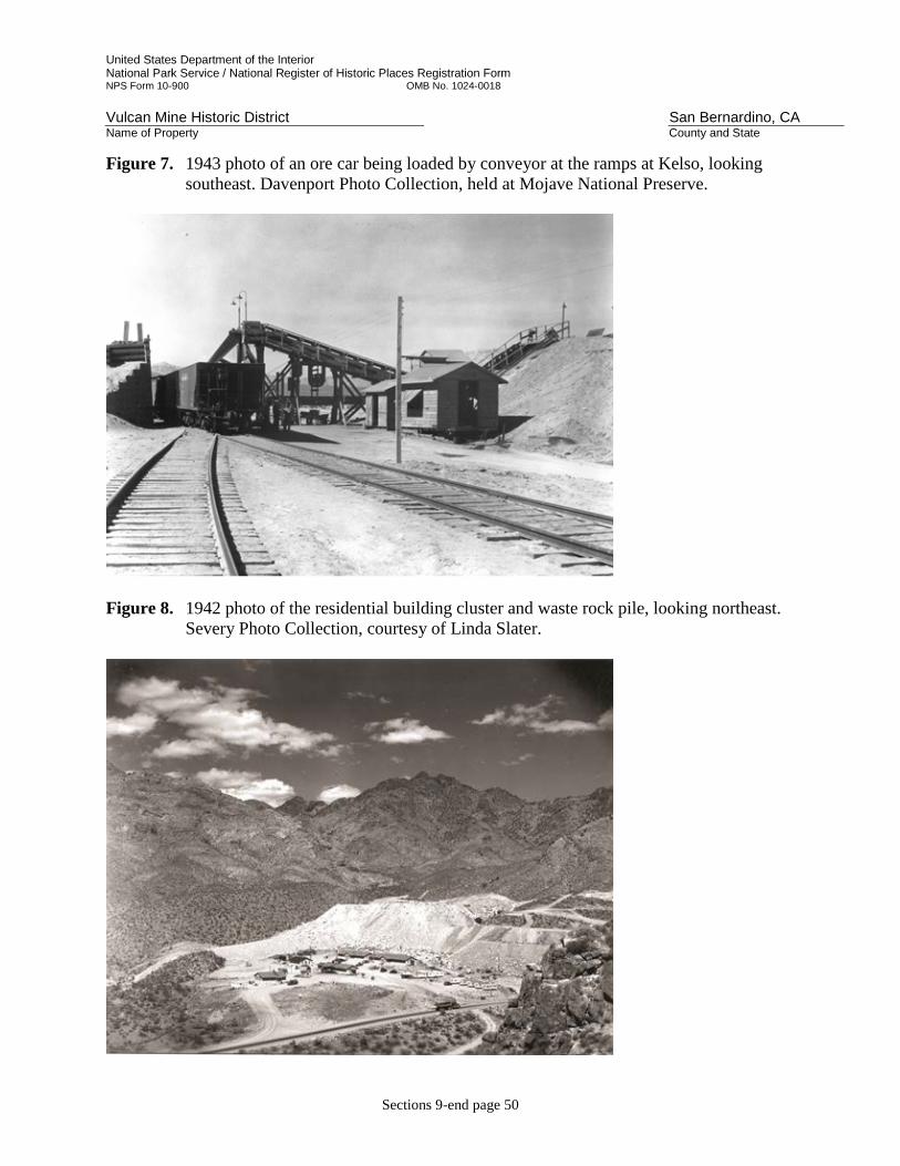
United States Department of the Interior National Park Service / National Register of Historic Places Registration Form NPS Form 10-900 OMB No. 1024-0018 Vulcan Mine Historic District San Bernardino, CA Name of Property County and State
Sections 9-end page 50
Figure 7. 1943 photo of an ore car being loaded by conveyor at the ramps at Kelso, looking southeast. Davenport Photo Collection, held at Mojave National Preserve.
Figure 8. 1942 photo of the residential building cluster and waste rock pile, looking northeast.
Severy Photo Collection, courtesy of Linda Slater.
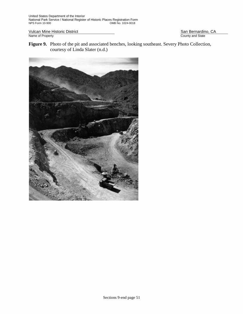
United States Department of the Interior National Park Service / National Register of Historic Places Registration Form NPS Form 10-900 OMB No. 1024-0018 Vulcan Mine Historic District San Bernardino, CA Name of Property County and State
Sections 9-end page 51
Figure 9. Photo of the pit and associated benches, looking southeast. Severy Photo Collection, courtesy of Linda Slater (n.d.)

United States Department of the Interior National Park Service / National Register of Historic Places Registration Form NPS Form 10-900 OMB No. 1024-0018 Vulcan Mine Historic District San Bernardino, CA Name of Property County and State
Sections 9-end page 52
Photo 1
Photo 2

United States Department of the Interior National Park Service / National Register of Historic Places Registration Form NPS Form 10-900 OMB No. 1024-0018 Vulcan Mine Historic District San Bernardino, CA Name of Property County and State
Sections 9-end page 53
Photo 3
Photo 4
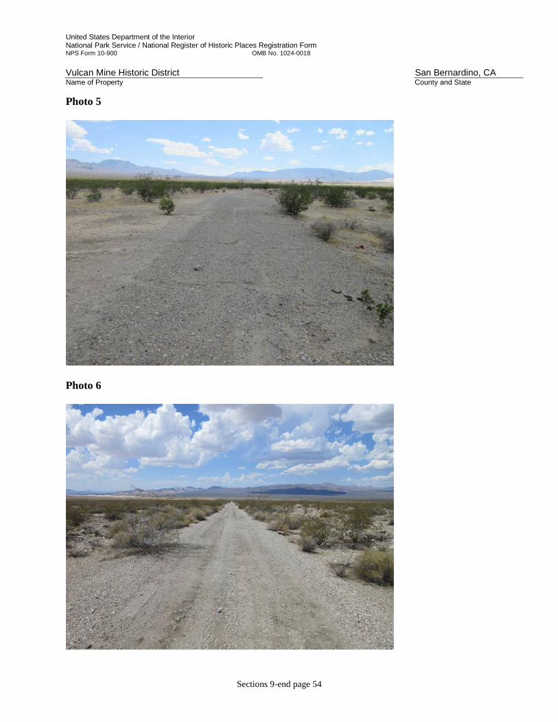
United States Department of the Interior National Park Service / National Register of Historic Places Registration Form NPS Form 10-900 OMB No. 1024-0018 Vulcan Mine Historic District San Bernardino, CA Name of Property County and State
Sections 9-end page 54
Photo 5
Photo 6

United States Department of the Interior National Park Service / National Register of Historic Places Registration Form NPS Form 10-900 OMB No. 1024-0018 Vulcan Mine Historic District San Bernardino, CA Name of Property County and State
Sections 9-end page 55
Photo 7
Photo 8

United States Department of the Interior National Park Service / National Register of Historic Places Registration Form NPS Form 10-900 OMB No. 1024-0018 Vulcan Mine Historic District San Bernardino, CA Name of Property County and State
Sections 9-end page 56
Photo 9
Photo 10

United States Department of the Interior National Park Service / National Register of Historic Places Registration Form NPS Form 10-900 OMB No. 1024-0018 Vulcan Mine Historic District San Bernardino, CA Name of Property County and State
Sections 9-end page 57
Photo 11
Photo 12
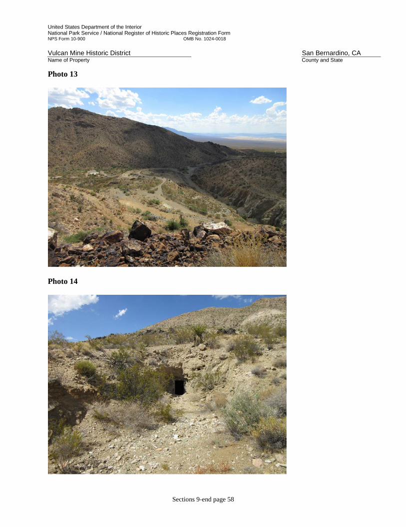
United States Department of the Interior National Park Service / National Register of Historic Places Registration Form NPS Form 10-900 OMB No. 1024-0018 Vulcan Mine Historic District San Bernardino, CA Name of Property County and State
Sections 9-end page 58
Photo 13
Photo 14

United States Department of the Interior National Park Service / National Register of Historic Places Registration Form NPS Form 10-900 OMB No. 1024-0018 Vulcan Mine Historic District San Bernardino, CA Name of Property County and State
Sections 9-end page 59
Photo 15
Photo 16

United States Department of the Interior National Park Service / National Register of Historic Places Registration Form NPS Form 10-900 OMB No. 1024-0018 Vulcan Mine Historic District San Bernardino, CA Name of Property County and State
Sections 9-end page 60
Photo 17
Photo 18

United States Department of the Interior National Park Service / National Register of Historic Places Registration Form NPS Form 10-900 OMB No. 1024-0018 Vulcan Mine Historic District San Bernardino, CA Name of Property County and State
Sections 9-end page 61
Photo 19
Photo 20

United States Department of the Interior National Park Service / National Register of Historic Places Registration Form NPS Form 10-900 OMB No. 1024-0018 Vulcan Mine Historic District San Bernardino, CA Name of Property County and State
Sections 9-end page 62
Photo 21
Photo 22