
NORTH HOYLE OFFSHORE WIND FARM JANUARY … Chart 15 - North Hoyle.pdf · The North Hoyle Offshore...
3
The North Hoyle Offshore Wind Farm is operated by Innogy SE. It is situated approximately 7.2 km from shore in the Southern Irish Sea, off the North Wales coast. The wind farm is fully operational and has 30 turbines, a total capacity of 60 MW and covers an area of approximately 10 km². NORTH HOYLE OFFSHORE WIND FARM JANUARY 2018 ADMIRALTY CHART OF WIND FARM HERE +44(0)845 0782922 1. If you suspect you have snagged a subsea cable or renewable energy structure, DO NOT endanger your vessel and crew by attempting to recover your gear. 2. Carefully plot your vessel’s position as accurately as possible. 3. Advise the Coastguard of your situation, and call the 24 hour Emergency Number and state that an incident is occurring concerning a subsea cable or renewable energy structure.
Transcript of NORTH HOYLE OFFSHORE WIND FARM JANUARY … Chart 15 - North Hoyle.pdf · The North Hoyle Offshore...
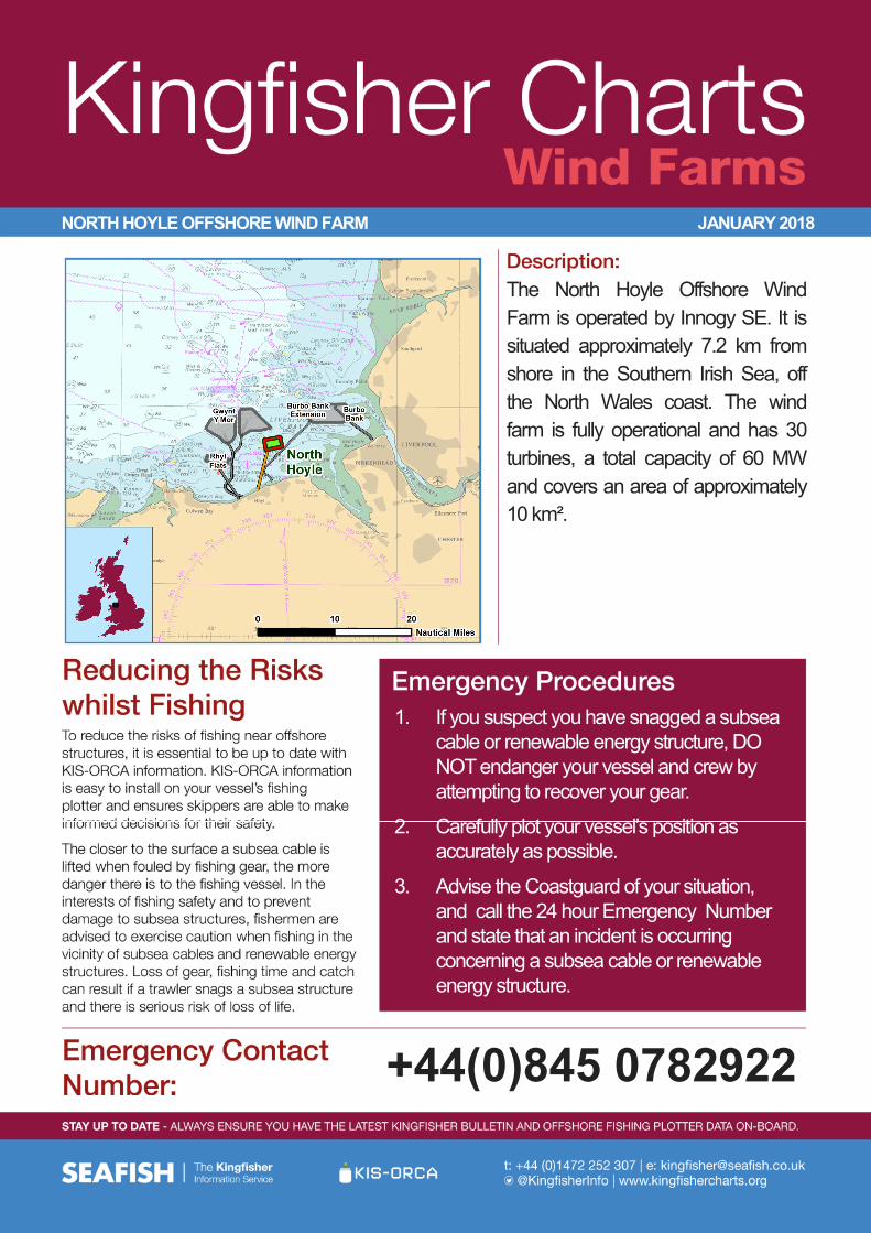
The North Hoyle Offshore Wind Farm is operated by Innogy SE. It is situated approximately 7.2 km from shore in the Southern Irish Sea, off the North Wales coast. The wind farm is fully operational and has 30 turbines, a total capacity of 60 MW and covers an area of approximately 10 km².
NORTH HOYLE OFFSHORE WIND FARM JANUARY 2018
ADMIRALTY CHART OF WIND FARM HERE
+44(0)845 0782922
1. If you suspect you have snagged a subsea cable or renewable energy structure, DO NOT endanger your vessel and crew by attempting to recover your gear.
2. Carefully plot your vessel’s position as accurately as possible.
3. Advise the Coastguard of your situation, and call the 24 hour Emergency Number and state that an incident is occurring concerning a subsea cable or renewable energy structure.
F10HF11H
F12H F13FF14E F15E F16E F17E F18E
G11H G12H G13GG14F
G15E G16E G17E G18E G19E
H11HH12H
H13GH14G
H15FH16F H17F H18F H19F H20F
H21F
J11HJ12G
J13G J14G J15G J16G J17F
K10G K11GK9H
L8H
NH01 NH02NH03
NH04 NH05NH06NH07
NH08 NH09NH10
NH11NH12
NH13NH14 NH15
NH16NH17
NH18NH19 NH20
NH21NH22
NH23 NH24NH25NH26 NH27
NH28NH29 NH30
SUBSTATION EAST
MET MAST
H21F
North HoyleWind Farm
A
B
C
D
3°20'W
3°20'W
3°21'W
3°21'W
3°22'W
3°22'W
3°23'W
3°23'W
3°24'W
3°24'W
3°25'W
3°25'W
3°26'W
3°26'W
3°27'W
3°27'W
3°28'W
3°28'W
3°29'W
3°29'W
3°30'W
3°30'W
3°31'W
3°31'W
3°32'W
3°32'W
3°33'W
3°33'W
3°34'W
3°34'W53
°26'N
53°26
'N
53°26
'N
53°26
'N
53°25
'N
53°25
'N
53°23
'N
53°23
'N
53°23
'N
53°23
'N
53°22
'N
53°22
'N
53°21
'N
53°21
'N
0 0.4 0.8 1.2 1.6
Nau tical Miles
1:50,000S cale @ A3:
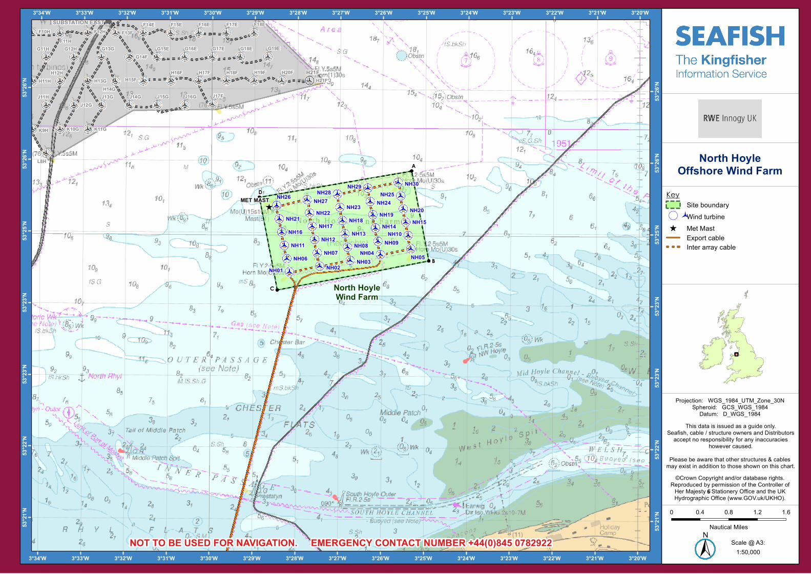
North HoyleOffshore Wind Farm
±NOT TO BE USED FOR NAVIGATION. EMERGENCY CONTACT NUMBER +44(0)845 0782922
©Crown Copyrigh t and/or database righ ts.Reprodu ced by perm ission of th e Controller ofHer Majesty’s S tationery Office and th e UKHydrograph ic Office (www.GOV.u k/UKHO).
Th is data is issu ed as a gu ide only.S eafish , cab le / stru c tu re owners and Distrib u torsac cept no responsib ility for any inac c u rac ies
h owever cau sed.Please be aware th at oth er stru c tu res & cab les m ay exist in addition to th ose sh own on th is c h art.
KeyS ite b ou ndary
( Wind tu rb ine_̂ Met Mast
Export cab leInter array cab le
Projec tion: WGS _1984_UTM_Zone_30NS ph eroid: GCS _WGS _1984Datu m : D_WGS _1984
EXTENTS
A 53°25.873'N 03°25.323'W
B 53°24.618'N 03°24.909'W
C 53°24.201'N 03°28.450'W
D 53°25.495'N 03°28.879'W
TURBINES
NH01 53°24.455'N 03°28.166'W
NH02 53°24.538'N 03°27.458'W
NH03 53°24.622'N 03°26.750'W
NH04 53°24.705'N 03°26.041'W
NH05 53°24.789'N 03°25.333'W
NH06 53°24.640'N 03°28.227'W
NH07 53°24.724'N 03°27.519'W
NH08 53°24.807'N 03°26.811'W
NH09 53°24.891'N 03°26.102'W
NH10 53°24.974'N 03°25.394'W
NH11 53°24.825'N 03°28.289'W
NH12 53°24.910'N 03°27.580'W
NH13 53°24.993'N 03°26.871'W
NH14 53°25.076'N 03°26.163'W
NH15 53°25.160'N 03°25.455'W
INFRASTRUCTURE
MET MAST 53°25.360'N 03°28.649'W
TURBINES
NH16 53°25.011'N 03°28.350'W
NH17 53°25.094'N 03°27.641'W
NH18 53°25.177'N 03°26.933'W
NH19 53°25.261'N 03°26.224'W
NH20 53°25.344'N 03°25.515'W
NH21 53°25.195'N 03°28.412'W
NH22 53°25.279'N 03°27.703'W
NH23 53°25.363'N 03°26.994'W
NH24 53°25.446'N 03°26.286'W
NH25 53°25.525'N 03°25.577'W
NH26 53°25.381'N 03°28.472'W
NH27 53°25.464'N 03°27.763'W
NH28 53°25.548'N 03°27.056'W
NH29 53°25.632'N 03°26.347'W
NH30 53°25.715'N 03°25.638'W


![Mars project chelsea hoyle [autosaved]](https://static.fdocuments.in/doc/165x107/55504c69b4c9058f768b51f5/mars-project-chelsea-hoyle-autosaved.jpg)