North Gateway Village Core Plan - City of Phoenix Home · The North Gateway Village Core Plan is...
38
North Gateway Village Core Plan Prepared by the City of Phoenix Planning Department January 30, 2008
Transcript of North Gateway Village Core Plan - City of Phoenix Home · The North Gateway Village Core Plan is...

North Gateway Village Core Plan
Prepared by the City of PhoenixPlanning Department
January 30, 2008

Introduction.................................................................1
Vision.......................................................................... 2
Background................................................................ 3Relationship to Other Plans and Policies.............. 3
Phoenix Urban Village Model.......................... 3General Plan for Peripheral Area C and D...... 4North Black Canyon Corridor Plan.................. 4Sonoran Preserve Master Plan....................... 5City of Phoenix General Plan.......................... 5
Opportunities and Constraints..................................8Natural Features and Recreational Amenities....... 8View Corridors....................................................... 8Existing Zoning...................................................... 10Various Landowners.............................................. 10Circulation/Transportation Corridors...................... 10
Goals............................................................................12North Gateway Village Core Plan Goals................ 12Goal 1 - Mix Land Use Development..................... 12Goal 2 - Accessibility and Pedestrian
Connectivity.............................................. 13Goal 3 - Economic/Employment Opportunities...... 14Goal 4 - Environmentally Sensitive........................ 14
Land Use Element...................................................... 16Existing Land Use................................................... 16North Gateway Village Core Plan........................... 16Conceptual Land Use Map..................................... 17
Commercial Center/Commerce Park.................17Mixed Use, Commercial/Residential and Retail/Residential............................................... 17Paseo del Prado................................................ 19Resort/Residential............................................. 19Open Space/Public Space................................. 19
Economic Development............................................. 23Existing Conditions................................................. 23North Gateway Village Core Plan........................... 25
Circulation.................................................................. 27Existing Conditions................................................. 27North Gateway Village Core Plan........................... 27
Paseo del Prado - Pedestrian Spine................. 28Paseo/Trail System............................................29Roundabouts......................................................30Parking/Parking Structures................................ 31
Conclusion and Implementation............................... 34
i
TABLE OF CONTENTSTABLE OF CONTENTSPage Page

ACKNOWLEDGEMENTSACKNOWLEDGEMENTS
ii
CITY COUNCILMayor - Phil Gordon
Vice Mayor - Dave SiebertCouncilwoman - Peggy NeelyCouncilwoman - Peggy Bilsten
Councilman - Tom SimplotCouncilman - Claude MattoxCouncilman - Greg StantonCouncilman - Doug Lingner
Councilman - Michael Johnson
PLANNING COMMISSIONDon Keuth - Chair
Melissa Gallegos - Vice ChairDwight AmeryThomas AwaiCharlie EllisWes GullettJohn Hart
Andrea KatsenesBilly Shields
NORTH GATEWAY VILLAGE PLANNING COMMITTEEDean Howard - Chair
Michael Frazier - Vice ChairLarry BalcomPhil Gardner
Steve MuroskyBrian Frisby
CITY MANAGERFrank Fairbanks
DEPUTY CITY MANAGERDavid Cavazos
PLANNING DIRECTORDebra Wilkins Stark, AICP
CITY STAFFConnie Randall, AICP - Planning
Donna Stevens - PlanningAlan Stephenson - PlanningJordan Feld, AICP - Planning
Michelle Dodds, AICP - PlanningDean Brennan, AICP - Planning
Jane Bixler - PlanningCharlie Fitzhugh - Planning
Judith Burke - PlanningKen Black - Planning
Diana Moissonnier - PlanningHeide Young - StreetsBoyd Winfrey - Parks
Joseph Cascio - ParksDoug Frost - WaterAndy Terrey - WaterSteve Rossi - Water

iii

The North Gateway Village Core (the Core) encompassesapproximately 500 acres along the east side of Interstate 17.The Core is bounded by the Skunk Creek Wash SonoranPreserve on the west, North Valley Parkway on the east, andDove Valley Road on the north, and extends approximately ½mile south of Lone Mountain Road. The Core is planned asa cohesive, environmentally sensitive community with mixedincome levels, employment opportunities, retail services, andrecreational amenities.
Various land uses have been strategically identified on theConceptual Land Use Map (pg. 22) to create a sense of placefor the Core with a pedestrian-oriented focus. Land uses thatstrengthen the sense of place and enhance the economicviability include broad categories of residential/commercialmixed use, residential/office mixed use, commercial, office,commerce/business park, and public uses.
The North Gateway Village Core Plan is designed to create ahigh density, urban environment that will reduce automobiletrips, support transit, and promote the Skunk Creek Wash asa major natural amenity that allows for a paseo/trailopportunity. The Core provides a strong sense of place fordevelopment along a pedestrian spine connecting SkunkCreek Wash to Bronco Butte that will enhance the integrity ofthe mixed-use development as a true urban experience.
NORTH GATEWAY VILLAGE
INTRODUCTIONINTRODUCTION
1

The North Gateway Village Core will be a lively, dynamic,interesting place to live, work, shop and play. The Core haslong been envisioned as an important regional employmentcenter with an urban character. This area will attract highintensity and high density development with a mix of buildingheights, up to 10 stories. The urban form of the Core will bedesigned to integrate with the desert environment.Residential communities that accommodate a variety ofincome levels, with employment, retail, and recreationalopportunities will develop within the Core and the surroundingarea. Development should integrate mixed use retail,restaurant, offices, residential units, and pedestrian-orientedopen spaces in an urban environment to establish the Coreas a destination place.
Employment opportunities that create quality jobs sensitive tothe environment and surrounding communities are highlydesired. The Core will become home to a variety ofemployers, ranging from small, independent offices providingprofessional services to the corporate headquarters of majorcorporations, such as the bio-tech and medical industries.
The Skunk Creek Wash, Bronco Butte and Bronco Tank arevaluable natural features that provide a sense of identity andcharacter to the Village. The Core is strategically located tobuild on and enhance these natural amenities. Preservationof views to and from these amenities will serve to solidify thecharacter of the Core and serve as a logical focal point forpedestrian-oriented commercial activities and recreationalopportunities for future residents.
A key feature of the vision for the Core is an urban walkwayconnecting Skunk Creek Wash to Bronco Butte to provideaccess to these recreational areas and the planned districtpark on the west side of the Skunk Creek Wash. As aneast/west pedestrian corridor through the heart of the Core,the urban walkway will also create a place for outdooractivities. Gardens and pedestrian plazas that interface witha combination of retail, office, residential and public activitiesshould create a focal point and hub of activity for the Core.The urban walkway, outdoor plazas and paseo along SkunkCreek will attract pedestrian visitors and local employeesduring the day, while commercial retail, restaurants, andnightclubs will provide primary entertainment in the evening.
The dynamic mix of commercial, employment, residential andopen space uses will result in quality developments thatpromote higher densities, support transit, reduce automobiletrips, and preserve the natural environment.
VISIONVISION
2

The North Gateway Village Core is a 500-acre area locatedapproximately 20 miles north of downtown Phoenix and issituated east of Interstate 17 between Dove Valley Road andLone Mountain Road alignments. Currently undeveloped, theCore’s access points are from Interstate 17 at the Dove ValleyRoad and Lone Mountain Road alignments with additionalaccess off of the North Valley Parkway at North Foothill Driveand Bronco Butte Trail.
The majority of the topography of the North Gateway Core isflat with few recognizable land forms. Hydrology of the Coreis Skunk Creek Wash that flows from the northeast to thesouthwest. Vegetation of the Core consists of Upper Sonoranwhich is composed of small trees, bushes, shrubs andflowering ground cover. There are three primary landforms inthe Core: Skunk Creek Wash, Bronco Butte and Bronco Tank.Skunk Creek Wash is one of the primary tributaries of theNew River Drainage System. The wash provides the westernboundary of the Core and will provide great opportunities forrecreation and open space preservation. The highest point isBronco Butte and is the primary natural landmark. BroncoButte is located in the east-central portion of the site and theterminus of the Core spine “Paso Del Prado”. The westernbase of Bronco Butte is the location of the Bronco Tank, ariparian area centrally located in the Core. Bronco Tankshould be used as water feature that could incorporatevarious public spaces.
An integral part of the North Black Canyon Corridor Plan, theCore establishes opportunities for regional employmentcenters in mid-rise offices buildings surrounded by campusstyle offices. The City of Phoenix General Plan Land Use Map
designates the Core as Mixed Use (Commercial/CommercePark) providing the necessary flexibility to respond tochanging market conditions and opportunities.
Relationship to Other Plans and PoliciesNumerous factors have been considered in the developmentof this plan. Countless individuals and organizations haveprovided invaluable input into the development of the NorthGateway Village Core Plan. Outlined below are a number ofcity of Phoenix plans and policies that were considered in thedevelopment of the Plan.
Phoenix Urban Village Model Concepts of the Urban Village Model were developed in themid 1970’s by various citizen committees. The committeesidentified basic components and characteristics of a village.These components included: core, boundaries,neighborhood, and open space. In 1985, City Counciladopted Urban Village Concept into 1985-2000 General Plan.This plan established nine villages and Village PlanningCommittees. These nine committees providedrecommendations regarding planning issues to the PlanningCommission and City Council. The Village Model continuedto develop several principals and comments regarding thedesign of a village. Since the inception of the Village Model,the villages have grown from nine to fifteen.
BACKGROUNDBACKGROUND
3

The Urban Village Model “core” remains the central focus forthe village. The core is intended to provide intense land usepatterns for the village. The Village Model encouragesflexibility of land uses including office, retail, public,governmental, and residential.
General Plan for Peripheral Area C and DPlanning for this area was initiated in 1987. The GeneralPlan: Peripheral Areas C and D is a broad land use study forthe new growth area located north of the Central ArizonaProject Canal (CAP) and south of the Carefree Highway,between 67th Avenue to the west and the Scottsdalecorporate boundary to east. From 1985 to 1987, manyforums and advisory groups were appointed by the CityCouncil to guide the development of the plan.
The basis for the Plan was to develop a framework forconsistent goals and policy making for the 1985 – 2000General Plan. The Peripheral Areas C and D Plan identifieda location for the core site. The Area D Core was originallylocated northeast of the Outer Loop (present day Loop 101)and south of the Carefree Highway. The Core would bedesigned using southwestern landscape materials andgeared for the pedestrian.
The Area D Core would provide services, cultural andentertainment facilities that would complement the residentialuses. In addition the Core would be appropriate for business,professional and governmental uses with the possibility ofmedical facilities.
North Black Canyon Corridor PlanSince 1997, there have been a variety of planning effortsregarding the directives of the Strategic View of Growth. Oneof these directives focused on the North Black CanyonCorridor. The North Black Canyon Corridor Plan identifies thearea as a regional employment center. Four goals weredeveloped to provide a strategic framework that create ahighly desirable pattern of urban growth.
The Corridor Goals include: 1. Promote the North Black Canyon Corridor as a
regional employment center. 2. Achieve a balance between employment and housing. 3. Concentrate growth within a defined corridor. 4. Preserve North Sonoran desert amenities and use
these features to define community form and identity.
4
PHOENIX URBAN VILLAGE MODEL
Sonoran Preserve Master Plan In 1997, the Phoenix Parks and Recreation Department alongwith the cooperation of City Council prepared a master planto study and inventory undisturbed desert land in Phoenix.The master plan comprised of both of public and private landsevaluating natural features such as drainage systems, ridgelines, hill slopes, and native vegetation.
The majority of the outlying area in Phoenix is Arizona StateTrust Land. The Sonoran Preserve Master Plan includes twostudy areas, the North Study Area (NSA) and South Studyarea (SSA). The NSA is comprised of land north of theCentral Arizona Project Canal which includes North GatewayVillage, Desert View Village and portions of the Deer ValleyVillage.
Preservation of natural areas within the North GatewayVillage Core will have a profound effect on the entirecommunity. Preserved natural lands such as Skunk CreekWash, provide visual and emotional relief from the day-to-daystresses of living in an urban core setting. The preserve willalso positively affect residential and commercial propertyvalues and development patterns.
The Sonoran Preserve Master Plan integrates the desertlandscape with the Urban Village Model. The Plan presents asystem trail connections and access points throughout theidentified preserve areas. Skunk Creek will provide excellentrecreational and open space opportunities for the NorthGateway Village Core.
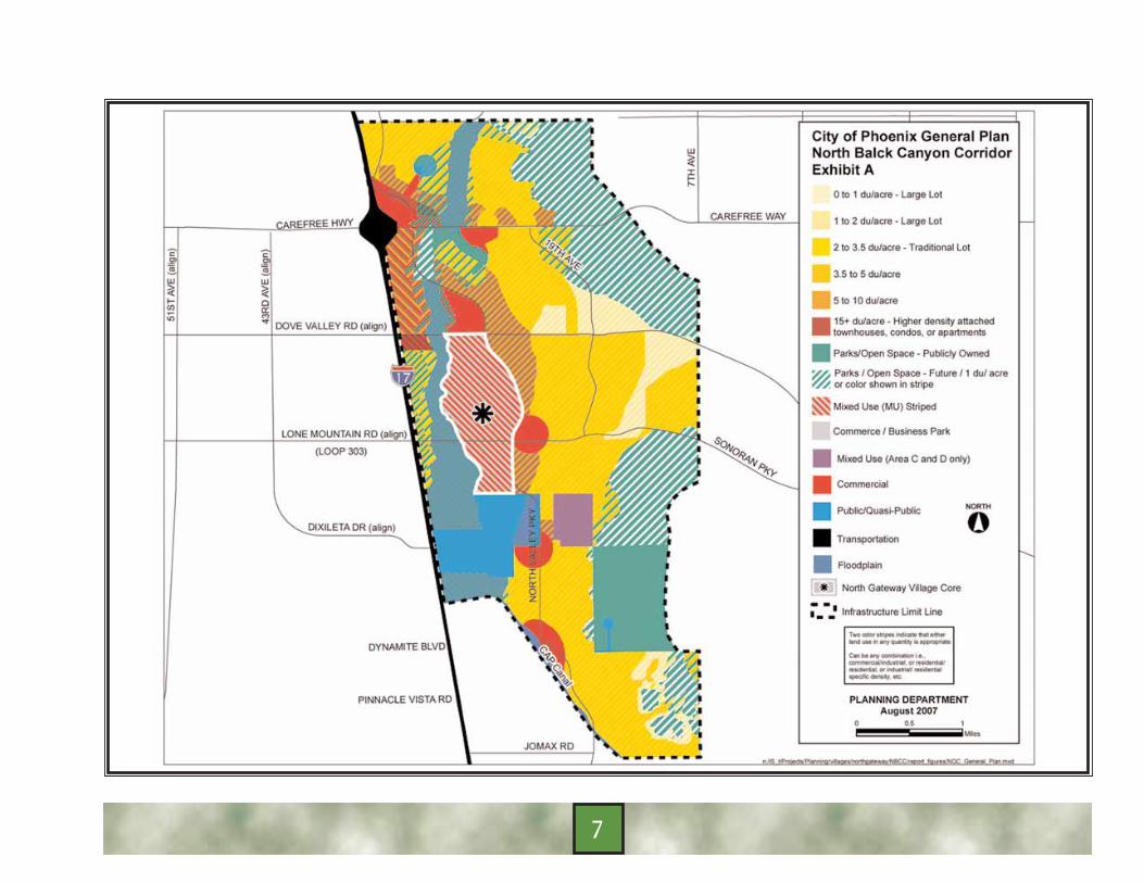
City Of Phoenix General PlanThe City of Phoenix General Plan identifies the Core as thecentral focus for the North Gateway Village with a pedestrian-oriented mix of land uses. The General Plan Land Use Map,shown in Exhibit A,(pg.7) designates the area as a mix ofCommercial and Commerce/Business Park uses. The NorthGateway Village Core Plan seeks to implement the goals andpolicies of the General Plan.
The following goals and policies are particularly relevant tothe North Gateway Village Core Plan:
Growth Area Element Goal 1; Growth: Maintain a high quality of life andeconomically healthy community.
Land Use Element Goal 1; Urban Form: Growth should be structured into aseries of Urban Villages characterized by the fivecomponents of the Urban Village Model: Core,Neighborhoods, Community Service Areas, RegionalService Areas, and Open Space.
Core Policy 1: Locate land uses with the greatestheight and most intense uses within limits based onvillage character, land use needs, and transportationsystem capacity.
Goal 2; Employment and Population Balance:Development of each Village’s potential should beencouraged by distributing a diversity of employment andhousing in a way that achieves a balanced citywide plan
5

and that is consistent with commute travel patterns andthe current character of each developed village.
Cost of Development ElementGoal 1; New Development’s Financial Responsibility: Newdevelopment in the city of Phoenix should not place afinancial burden on existing development except wherethe bonding capacity of existing development is used forconstruction of facilities until revenues from newdevelopment are available.
Circulation ElementGoal 1; An Effective Multi-Modal Transportation System: Amulti-modal transportation system should be developedthat will allow the movement of goods and people safelyand efficiently throughout the city, especially into andbetween, the Urban Village Cores.
Goal 2; Surface Streets and Parking Facilities: A systemof streets and parking facilities should be designed anddeveloped that matches the capacity and character of thestreet with the character of the area and projectedautomobile, truck, bicycle, and transit travel demands,support land use and other General Plan objectives.;makes efficient use of streets, enhances traffic safety, andresults in adequate paring facilities.
Housing ElementGoal 2; Housing Choice: A diverse choice of housingshould be provided in all villages of the city to meet theneeds of all households.
Neighborhood ElementGoal 1; New Neighborhood Design: All neighborhoodsshould be designed to be safe, well maintained,pedestrian oriented, desirable places to live.
Environmental Planning ElementGoal 1; Natural/Physical Environment: The naturalphysical environment should be preserved and conservedwhile acknowledging that development will occur in someareas.
Open Space ElementGoal 2; Linear Open Space: Linear systems of openspace such as canals, washes, drainage corridors, andrivers should contribute to a continuous non-motorizedtrail system that serves as an alternative transportationsystem, provide a positive recreational experience andforms a neighborhood amenity.
Recreation ElementGoal 1; Parks System: The Parks and recreation systemshould meet the needs of residents and visitors, beaccessible, convenient, and diverse in locations,programs, and facilities.
Water Resources Element Goal 1; Water Resources: Provide a reliable supply ofhigh quality water at a reasonable cost, while balancingsocial, economic, and environmental impacts of waterresources development projects and water demandmanagement programs.
6
7
Development of the North Gateway Village Core will need torespond to a wide variety of factors, including patterns ofemployment, housing, site planning, and transportationtechnologies.
The City of Phoenix General Plan Land Use Map designatesthe North Gateway Village Core as Mixed Use (Commercialand Commerce/Business Park). The Core is located withinthe North Black Canyon Corridor which is a sub area of theNorth Gateway Village. Various opportunities are present fora successful core with minimal constraints that can beaddressed by adequate planning. A map of the NorthGateway Village Core Opportunities is shown in Exhibit B (pg. 11).
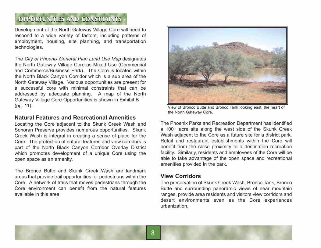
Natural Features and Recreational AmenitiesLocating the Core adjacent to the Skunk Creek Wash andSonoran Preserve provides numerous opportunities. SkunkCreek Wash is integral in creating a sense of place for theCore. The protection of natural features and view corridors ispart of the North Black Canyon Corridor Overlay Districtwhich promotes development of a unique Core using theopen space as an amenity.
The Bronco Butte and Skunk Creek Wash are landmarkareas that provide trail opportunities for pedestrians within theCore. A network of trails that moves pedestrians through theCore environment can benefit from the natural featuresavailable in this area.
View of Bronco Butte and Bronco Tank looking east, the heart ofthe North Gateway Core.
The Phoenix Parks and Recreation Department has identifieda 100+ acre site along the west side of the Skunk CreekWash adjacent to the Core as a future site for a district park.Retail and restaurant establishments within the Core willbenefit from the close proximity to a destination recreationfacility. Similarly, residents and employees of the Core will beable to take advantage of the open space and recreationalamenities provided in the park.
View CorridorsThe preservation of Skunk Creek Wash, Bronco Tank, BroncoButte and surrounding panoramic views of near mountainranges, provide area residents and visitors view corridors anddesert environments even as the Core experiencesurbanization.
OPPORTUNITIES AND CONSTRAINTSOPPORTUNITIES AND CONSTRAINTS
8

View of Pyramid Peak
The North Gateway Village Core is in proximity to the NoName Mountains, Pyramid Peak, and Union Hills wherescenic views may be enjoyed.
This urbanization responds to the fundamental principle ofthe General Plan regarding strategic placement of growth andcontaining the built environment within a broader regionwhere natural features predominate.
View corridors add to the sense of place for the NorthGateway Village Core. Views from office buildings, hotels,residential units, public spaces and retail centers add value tothe property.
The North Gateway Village Core Plan has been designed toaccommodate the various views that support the overallcharacter with the Core’s trails and circulation patterns.
This view of Piestewa Peak, preserved in the Camelback East Village Core, illustrates the view corridor concept.
Development of local streets with buildings orientated to thestreet will help meet the view corridor vision.
Future development patterns along the Paseo del Pradoshould promote the vistas of Union Hills, No NameMountains, and Pyramid Peak as illustrated in Exhibit B (pg. 11).
The urban Core should work in concert with views to openspaces to establish successful land use patterns thatembrace the natural environment while urban developmentoccurs.
9

Existing ZoningThe Core has approved zoning of C-2 (IntermediateCommercial) and/or CP (Commerce Park) with a Mid-RisePlanned Community District. The ability to master plancommercial land uses in this area offers the City a uniqueopportunity to achieve design continuity and coordination ofinfrastructure development in the Core area. Establishedzoning also supports employment and retail opportunities forthe Core.
The zoning classifications will allow the Core to develop usingmarket conditions and the goals of the North Gateway VillageCore Plan. The existing zoning classifications are defined bytwo major Planned Community District (PCD) rezoning cases,Z-43-99-2 (Sonoran Foothills-McEwen Trust PCD) andzoning case Z-34-01-2 (North Gateway PCD).
Various LandownersThere are more than a dozen individual property ownerswithin the Core. In order for the Core to be successful,cooperation between landowners, developers, and the City iscrucial. Collaborative efforts with a shared vision for the areais key to successful development that will increase real estatevalues, create vitality in the community, and generaterevenues and employment opportunities. Absent a cohesiveplan and shared vision for the Core, development ofindividual properties on a parcel by parcel basis could be aconstraint.
Circulation/Transportation CorridorsDevelopment of a circulation plan should take advantage ofthe existing road patterns of I-17, North Valley Parkway, DoveValley and Lone Mountain Roads along with platted roadsfrom Sonoran Foothills PCD. This street pattern segmentsparcels creating ingress/egress opportunities for theindividual property owners, establishes transportations routesfor potential transit, and creates view corridors.
Topography is also a key factor in the circulation plan.Identifying key areas such as Skunk Creek Wash and how itrelates to Bronco Butte and Bronco Tank is paramount.
10

11
North Gateway Village Core Plan GoalsThe North Gateway Village Core Plan has been prepared forthe purpose of ensuring consistently high quality, pedestriandesign and development for the Core and encouraging mixeduse development that supports employment and economicgrowth. This purpose can be achieved by guiding developersand builders through the entitlement process and byidentifying the parameters within which development shouldoccur.
Along with design guidelines and other ordinances andregulations, the North Gateway Village Core Plan protectsundeveloped areas from undesirable design anddevelopment by assuring aesthetically consistent andappropriate development with an emphasis on thepedestrian.
The North Gateway Village Core Plan supportsneighborhoods with mixed-use housing opportunities, abusiness district, entertainment and retail opportunities in anurban setting. The Core should function as a definedcommunity that protects the area’s natural resources andoffers a quality desert lifestyle.
Goal 1 - Mix Land Use DevelopmentThe North Gateway Village Core should be a desirable livingenvironment which provides a mix of residential, employment,retail, and recreational amenities with a strong identity.
Policies:A. Manage development so that is occurs in a compact,
urban manner.B. Create a vibrant urban environment with a variety of
mixed uses.C. Cluster compatible uses to establish a pedestrian envi-
ronment and decrease vehicular traffic.D. Emphasize pedestrian accessibility and connectivity
throughout the Core.
Recommendations:1. Encourage corporate office, retail, hotel, entertainment
complexes, and loft residential uses along Dove ValleyRoad and North Valley Parkway.
2. Locate mixed-use development along the pedestrian Paseo del Prado emphasizing specialty retail and res-idential uses.
3. Encourage the development of a major resort/ hotel and related uses such as restaurants/cafes into the streetscape adjacent to Skunk Creek Wash to capture the views and amenities the Sonoran Preserve can offer.
4. Locate Mid-rise office, commercial and retail north and south of Bronco Butte along North Valley Parkway cap-turing the bio-tech research market, medical offices, and related uses.
5. Create a demand for the mixed use commercial serv-ices by encouraging high-density residential uses sur-rounding the Paseo del Prado.
6. Adopt design guidelines for the North Black Canyon Overlay zoning district that address urban form, including, but not limited to:
GOALSGOALS
12

a) Site design and building orientationb) Urban open space and pedestrian gathering areas;c) View corridors;d) Pedestrian connections;e) Transit oriented developmentf) Parking lots and structures;
g) Street designh) Landscapingi) Artj) Lighting
k) Green building and sustainability
Kierland commonsillustrates how amixed-use retail/residentialdevelopmentprovides a uniqueenvironment.
Goal 2 - Accessibility and Pedestrian ConnectivityImprove mobility throughout the Core, within and betweendevelopments, to create a high quality of life for residents andlocal businesses.
As the Core experiences population and employment growththe pollution and congestion will increase. Developmentshould provide alternatives to this ongoing problem bypromoting multi-modal transportation systems and transit-oriented development.
Policies:A. Minimize the adverse impact of the transportation
system through integrated urban design. B. Promote active commercial centers that support
transit and public spaces through building intensities, orientation, and massing.
C. Emphasize mixed-use office and residential uses to increase the mixed-use, round-the-clock nature of the Core.
D. Promote pedestrian-oriented developments to reduce vehicular travel.
Recommendations:1. Encourage the use of roundabouts and other traffic
calming devices to manage the volume and speed of vehicular traffic.
2. Create connections between development sites to encourage pedestrian activity.
3. Develop a pedestrian connection between the Core and the planned district park along the west side of the
13

Skunk Creek Wash through the development of the Paseo del Prado.
4. Encourage safe, pleasant walking environments through regulation of urban form, including the treat-ment of streets, sidewalks, building entries, balconies, porches, and architectural features.
5. Locate employment-generating uses such as office buildings and employee intensive uses adjacent to the retail component of the Core.
6. Design development near transit centers to promote safe and convenient access to multi-modal transporta-tion systems to increase ridership.
7. Collaborate with Valley Metro to create special area plans, design guidelines, and partnership arrange-ments that support transit initiatives.
Goal 3 - Economic/Employment OpportunitiesCreate an employment hub to serve as a “mini downtown” forthe North Valley area to support the Village goal of creating anumber of jobs to equal 75 percent of the Village’s residentpopulation.
Policies:A. Create vibrant retail and commercial districts that meet
the needs of local residents and employees.B. Create a balance of quality employment and residen-
tial options to provide residents with an opportunity to live and work in the same or adjacent villages.
C. Attract a variety of employers, ranging from small, independent offices providing professional services (e.g., law, real estate, insurance, and health care) to headquarters of major corporations.
Recommendation1. Recruit businesses that complement the Core retail
and mix use development.2. Develop appropriate incentive programs to stimulate
the development of the bio-tech campus and specialty retail center.
3. Encouraging clusters of specialty retailers. 4. Encourage architecture that will withstand changes in
style and economy, enabling adaptive re-uses in the future.
5. Consider financial resources such as bond proposals for hotels, parking structures and civic amenities when feasible.
Goal 4 - Environmentally SensitiveDevelopment should be sensitive to the Skunk Creek Washand the Bronco Butte desert environments and all land usesshould minimize adverse environmental impacts and maintainexisting natural resources.
Policies:A. Retain and strengthen the significant features of the
natural landscape.B. Locate uses in a manner which minimizes conflict and
mitigates impacts to the environment.C. Respond to climatic factors and human comfort.D. Promote sustainable design concepts.
14

Recommendation:1. Promote strategies that preserve and protect the
ecological value of Skunk Creek Wash and Bronco Butte environments.
2. Retain view corridors of Bronco Butte, Pyramid Peak, Union Hills and No Name Mountains by limiting building heights to 10 stories and encouraging buildingstep backs as the height increases.
3. Encourage the use of reclaimed water, where feasible,in water features.
4. Promote the use of Green Building strategies.
Bronco Butte is a recognizable landmark in the North Gateway Village Core. Preserved natural environments offer a sense of place in an urban community.
15

Existing Land UseThe Core encompasses 500 acres of vacant, undevelopedland. The Core is separated from surrounding residential andcommunity uses by arterial streets and topography. Thisseparation provides an opportunity for the Core to developwith a unique identity and character. Bronco Butte, BroncoTank and the Skunk Creek Wash are natural features withinthe Core that should be preserved and enhanced as landdevelops.
North Gateway Village Core PlanThe North Gateway Village Core Plan implements the UrbanVillage Model by creating a destination with opportunities fora residential, employment, shopping, and recreationopportunities within the North Gateway Village.
The North Gateway Village Core’s mixed-use developmentarea is the primary location for major facilities within the NorthGateway Village. The North Black Canyon Corridor Planseeks to locate regional and major community uses in theCore. High density residential development is encouraged.Proximity to major transportation corridors, I-17, North ValleyParkway and Lone Mountain Road (Sonoran Boulevard to theeast and SR 303 to the west), supports the intensity anddensity of land uses planned for the Core.
A central plaza at Kierland Commons is surrounded by mixed-usebuildings with office, retail and residential uses.
The Conceptual Land Use Map for the North Gateway VillageCore, shown in Exhibit C (pg. 22),identifies the locations ofvarious land uses in relationship with existing knownopportunities and constraints. The Conceptual Land UseMap aims to build on and enhance the attributes of theSonoran Desert to create a destination. The Core will haveits own distinctive identity that builds on the dominance of theSkunk Creek Wash and Bronco Butte as a regional imageand provide linkages from one destination to another.
The North Gateway Village Core Plan seeks to combat urbansprawl by locating intense land uses and high densities in onecentralized destination. Development will be encouraged to
LAND USE ELEMENTLAND USE ELEMENT
16
preserve views of natural features within the Core by limitingthe building height to 10 stories and providing building stepbacks to avoid massive walls as the height increases. Theurban form should be conscious of natural amenitiessurrounding the Core and promote a seamless integrationbetween the built and natural environment. Commerce andindustry, diverse residential units, urban entertainmentdistricts, restaurants, parks, and open spaces define theCore.
Conceptual Land Use MapThe Conceptual Land Use Map promotes a functional andequitable mix of uses to establish a strong sense ofcommunity. The fundamental goal of the North GatewayVillage Core is to encourage a broad spectrum of uses andstructures to work together to create a vibrant community.The following broad land use categories have beendeveloped to further define how the Core is envisioned todevelop:
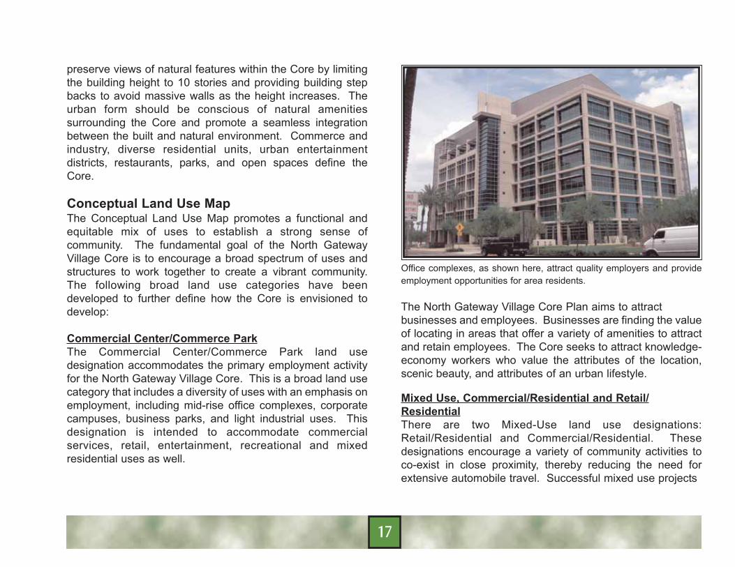
Commercial Center/Commerce ParkThe Commercial Center/Commerce Park land usedesignation accommodates the primary employment activityfor the North Gateway Village Core. This is a broad land usecategory that includes a diversity of uses with an emphasis onemployment, including mid-rise office complexes, corporatecampuses, business parks, and light industrial uses. Thisdesignation is intended to accommodate commercialservices, retail, entertainment, recreational and mixedresidential uses as well.
Office complexes, as shown here, attract quality employers and provideemployment opportunities for area residents.
The North Gateway Village Core Plan aims to attract businesses and employees. Businesses are finding the valueof locating in areas that offer a variety of amenities to attractand retain employees. The Core seeks to attract knowledge-economy workers who value the attributes of the location,scenic beauty, and attributes of an urban lifestyle.
Mixed Use, Commercial/Residential and Retail/ResidentialThere are two Mixed-Use land use designations:Retail/Residential and Commercial/Residential. Thesedesignations encourage a variety of community activities toco-exist in close proximity, thereby reducing the need forextensive automobile travel. Successful mixed use projects
17

The Post Property, on CentralAvenue and Portland, is amixed-use project with retailshops and a restaurant on thefirst floor and residential above.
blend office, retail and residential uses in a pedestrian-oriented project that minimizes travel distances betweenuses.
The Commercial/Residential designation is intended toaccommodate a variety of commercial, office, retail andresidential uses. An example of a successful mixed useproject is The Esplanade, located at the southeast corner of24th Street and Camelback Road, which has successfullyachieved a mixed-use multi-story office, retail, multi-family,and commercial in one cohesive development. Suchdevelopments often require developers, public agencies, andthe community to work together to create a successfulproject.
The Retail/Residential designation is intended to attractspecialty retail users with unique residential opportunitiesintegrated into the project. An example of this type ofdynamic mixed use project would be Kierland Commons,located on the west side of Scottsdale Road at theintersection of Greenway and Scottsdale Roads. Areasadjacent to the Paseo del Prado are designated asRetail/Residential to build on the unique atmosphere createdby the Paseo.
While retail is perhaps the most visible use in these projects,and requires considerable attention, housing is the essentialingredient that makes these projects successful. Whenpeople live within a core area, they take part in the life of theplan simply by carrying out their daily routines. The comingsand goings of residents, office workers, moviegoers, diners,and shoppers, all contribute to the round-the-clock rhythm ofa mixed use project. Housing is a key component thatsupports mixed-use development.
High density residentialopportunities are a keyingredient of successfulurban environments.
18

Paseo del PradoThe Paseo del Prado is the most important element of theCore. The Paseo del Prado is a pedestrian spine thatconnects Bronco Butte with Skunk Creek Wash and servesas a central focus for the Core. The Paseo del Prado isexpected to develop in a manner that preserves andenhances the views of Bronco Butte and Bronco Tank. Thisarea is envisioned to be a vibrant area offering diverseactivities throughout the day and evening, including uniqueshopping, dining, entertainment, and living opportunities.Various retail nodes and pedestrian plazas are anticipatedalong the Paseo. This urban design and place makingconcept is expected to attract various investments to theNorth Gateway Village Core.
Retail shops and restaurantswith outdoor dining line apedestrian plaza at theArizona Center.
Resort/ResidentialThe Resort/Residential designation is intended toaccommodate a major resort or hotel and related retail uses,such as restaurants and cafes, along the Skunk Creek Washto take advantage of and build on the scenic beauty andamenities available. Additionally, the Resort/Residential areais located in a position to anchor the mixed-use developmentsimmediately north. Various mixed-use projects around thecountry combine luxury condominiums with luxury hotels.Such pairings is evident in Phoenix with the success ofDesert Ridge/Marriott, Kierland Commons/Westin, and theEsplanade/Ritz Carleton. Hotels can enhance themarketability of office and residential uses just as retail andrestaurant uses can compliment the shopping environmentfor hotel guests and in turn improves the marketability of thehotel component.
Open Space/Public SpaceThe quality of the public space will be a major component ofthe success of the Core development. While not identified asa land use designation on the Conceptual Land Use Map,public spaces and pedestrian connectivity is a vitalcomponent in making the Core successful. Landscaping,pedestrian trail connections, open spaces and water featuresare illustrated on the Conceptual Land Use Map for thepurposes of conveying the intent that as the Core develops,each project should incorporate these concepts into their sitedesign. The objective is not to create or require public parksor dedicated trails through every project, but that considera-tion is given to how and where pedestrian access andamenities are provided for employees, visitors and residentsof the Core.
19

This image illustrates that live, work, play concept and the benefitof open space and recreational amenities.
Public spaces contribute to the identity of a place and are amajor factor in determining whether or not people want to live,work, shop, and play in the area. Successful public spacesdraw people to the development and create economic gainfor businesses located within.
A system of public spaces is envisioned by the creation of acentral focus. From Bronco Butte to Skunk Creek, the Paseodel Prado (pedestrian spine) transitions from the Bronco Tankarea to the Skunk Creek Wash and planned district park.The Paseo del Prado links the network of plaza areas, eachwith its unique presence and atmosphere.
Water features, like this fountain at La Encantada, provide avisual focal point and enhance the aesthetic quality of thedevelopment.
Focal points should be developed throughout the Coreoffering visual and recreational opportunities. Focal pointscan take a variety of forms, including active and passivewater features, statues and sculptures, and enhancedlandscaping. Where feasible, water features will beencouraged to utilize reclaimed water.
Throughout Phoenix, a variety of parks and open spaceshave been preserved in their natural state because of theirinherent recreational and aesthetic value. Some areas of theCity have physical constraints that preclude urbandevelopment of such parks. The City has developed parksprimarily for active and passive recreation uses, and in somecases, for drainage functions.
20
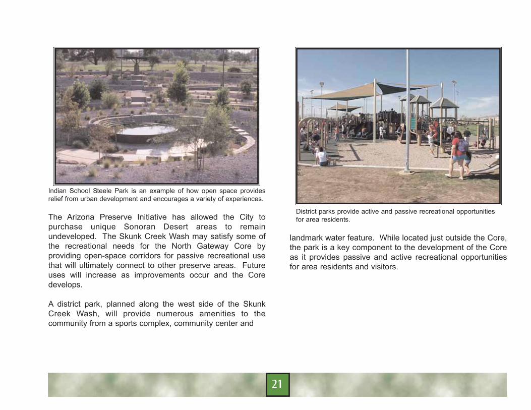
Indian School Steele Park is an example of how open space providesrelief from urban development and encourages a variety of experiences.
The Arizona Preserve Initiative has allowed the City topurchase unique Sonoran Desert areas to remainundeveloped. The Skunk Creek Wash may satisfy some ofthe recreational needs for the North Gateway Core byproviding open-space corridors for passive recreational usethat will ultimately connect to other preserve areas. Futureuses will increase as improvements occur and the Coredevelops.
A district park, planned along the west side of the SkunkCreek Wash, will provide numerous amenities to thecommunity from a sports complex, community center and
District parks provide active and passive recreational opportunitiesfor area residents.
landmark water feature. While located just outside the Core,the park is a key component to the development of the Coreas it provides passive and active recreational opportunitiesfor area residents and visitors.
21

22

Existing ConditionsThere are currently no existing employment or commercialdevelopments within the Core. A number of neighborhoodand community commercial nodes have been developed orare in the process of developing in the immediate vicinityincluding the northeast and northwest corners of North ValleyParkway and Carefree Highway and the southwest andsoutheast corners of 27th Avenue and Carefree Highway.Commercial development is planned for the southwest cornerof North Valley Parkway and Carefree Highway, thesouthwest corner of 27th Avenue and North Valley Parkway,the northeast and southeast corners of North Valley Parkwayand Lone Mountain Road/Sonoran Boulevard, and thenorthwest and northeast corners of North Valley Parkway andDynamite Boulevard. Additionally, the North Black CanyonMotorPlex is planned for the northeast corner of Interstate 17and Dove Valley Road.
The North Valley is a prime location for research, bio-tech,and high-technology operations. Due to new technologies,these land uses are environmentally friendly and lendthemselves to a pedestrian-oriented, campus-like setting.Major corporations are beginning to relocate in urban areasthat offer a higher quality of life than typical industrial parks.The industry is beginning to transform from single-use workzones into mixed-use, pedestrian oriented areas.
A 2003 market study prepared by Elliott Pollack, determinedthat the trade area surrounding the proposed Core mustconsist of high-density residential development to support a
retail/office market. The projected population density andspending power justifies a specialty retail project andassociated community retail.1
Given the projected population growth in north Phoenix, thecity of Peoria, and the towns of Cave Creek and Carefree, theMaricopa Association of Governments (MAG) research hasconcluded that a specialty serving retail project should befeasible sometime between the years 2010 - 2020 (Table 1)(pg. 24).
1 The population figures do not take in consideration the goal for high-density residential developmentin the core.
ECONOMIC DEVELOPMENTECONOMIC DEVELOPMENT
23
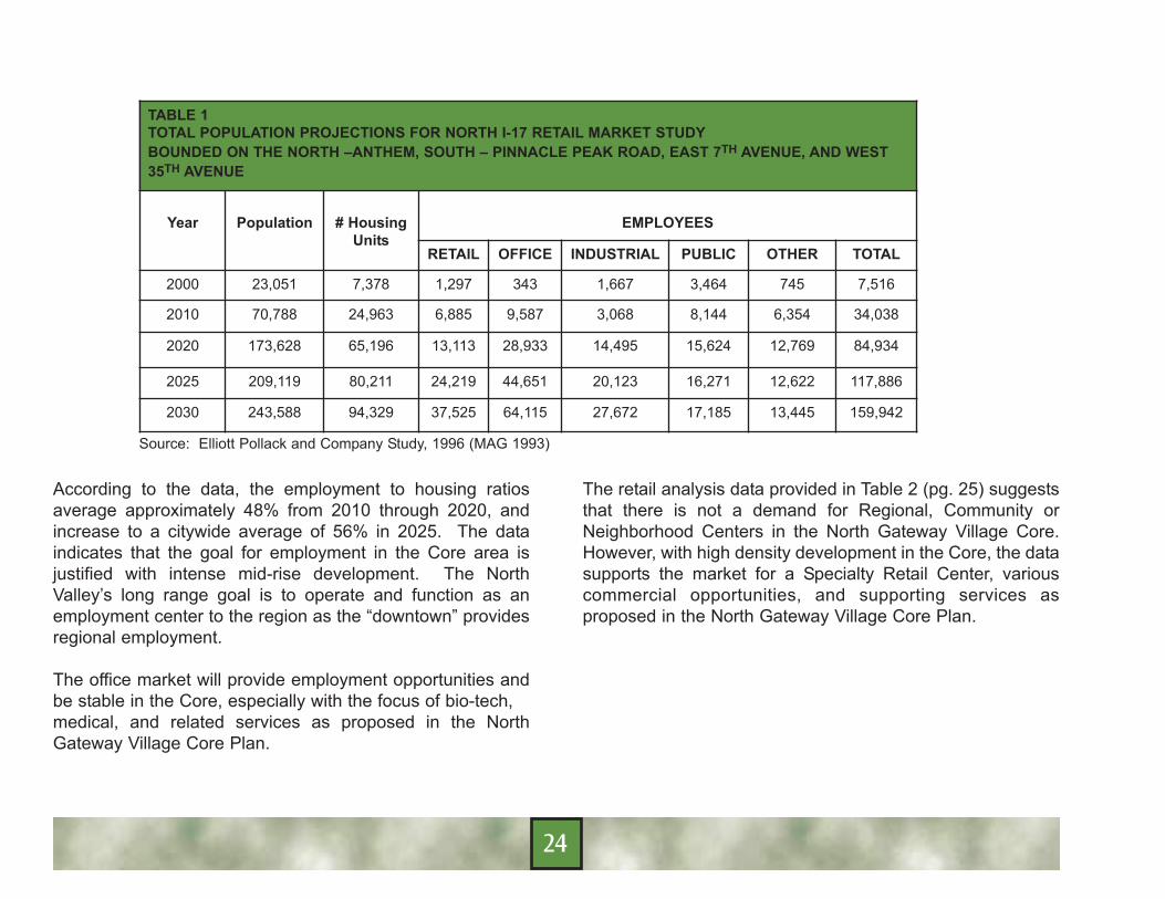
TABLE 1TOTAL POPULATION PROJECTIONS FOR NORTH I-17 RETAIL MARKET STUDYBOUNDED ON THE NORTH –ANTHEM, SOUTH – PINNACLE PEAK ROAD, EAST 7TH AVENUE, AND WEST35TH AVENUE
Year Population # HousingUnits
EMPLOYEES
RETAIL OFFICE INDUSTRIAL PUBLIC OTHER TOTAL
2000 23,051 7,378 1,297 343 1,667 3,464 745 7,516
2010 70,788 24,963 6,885 9,587 3,068 8,144 6,354 34,038
2020 173,628 65,196 13,113 28,933 14,495 15,624 12,769 84,934
2025 209,119 80,211 24,219 44,651 20,123 16,271 12,622 117,886
2030 243,588 94,329 37,525 64,115 27,672 17,185 13,445 159,942
According to the data, the employment to housing ratiosaverage approximately 48% from 2010 through 2020, andincrease to a citywide average of 56% in 2025. The dataindicates that the goal for employment in the Core area isjustified with intense mid-rise development. The NorthValley’s long range goal is to operate and function as anemployment center to the region as the “downtown” providesregional employment.
The office market will provide employment opportunities andbe stable in the Core, especially with the focus of bio-tech, medical, and related services as proposed in the NorthGateway Village Core Plan.
The retail analysis data provided in Table 2 (pg. 25) suggeststhat there is not a demand for Regional, Community orNeighborhood Centers in the North Gateway Village Core.However, with high density development in the Core, the datasupports the market for a Specialty Retail Center, variouscommercial opportunities, and supporting services asproposed in the North Gateway Village Core Plan.
Source: Elliott Pollack and Company Study, 1996 (MAG 1993)
24

North Gateway Village Core PlanOne of the planning goals expressed in the General PlanPeripheral Areas C and D is to “assure a fiscally sound landuse mix” supported by market demand. The goal furtherwarns that an over-reliance in one or two types of uses canresult in a deficit when public costs for providing services arecompared to revenue generated. The vision of the Core is toserve as a mini-downtown for the North Valley. To besuccessful, the Core must attract diverse employment uses.
The economic analysis provided by Elliott Pollack andCompany demonstrates that the Core area is ripe foremployment, neighborhood commercial service and specialtyretail uses. The Core is uniquely situated along majortransportation corridors to draw interest from the technology,
medical, and research industries as well as general office andspecialty retail users. This diversity of employmentopportunities is necessary to provide a sound economic basefor the North Gateway Village and the City.
The North Gateway Village Core will be known as adestination offering employment, entertainment, shopping,and recreation opportunities with progressive, moderndevelopment patterns building upon other core areadevelopments such as Desert Ridge and the Esplanade.
The City must monitor its economic development goals withmeasurable objectives such as job-creation, job retention, taxbase creation, increases in property values, economicstability, and economic self-sufficiency.
Key components of the North Gateway Village Core Plan isthe development of mid-rise office buildings, specialty retailstores, bio-tech research campuses, business centers,restaurants and hotels adjacent to Interstate 17. Corporateheadquarters are anticipated to locate in the Core to takeadvantage of the location.
TABLE 2RETAIL ANALYSIS POPULATION 243,588 (BUILD OUTPROJECTION)BOUNDED ON THE NORTH –ANTHEM, SOUTH – PINNACLEPEAK ROAD, EAST 7TH AVENUE, AND WEST 35TH AVENUE
Type DemandFactor
WithContingency
Square Foot Demand
Acre Demand
Regional 4.4 4.4 1,071,787 1,233,464
Community 9.5 9.5 2,314,086 266
Neighborhood 11.5 13.8 3,361,514 386
Specialty 3.4 4.1 993,839 114
TOTAL 28.8 31.8 7,741,227 889
Source: Elliott Pollack and Company Study, 1996 (MAG 1993)
25

The Core is poised to take advantage of the opportunity todevelop an environment where residents can live close totheir jobs. While typical urban sprawl locates people furtherout of the downtown, increasing the reliability on theautomobile and creating an influx in traffic, the North GatewayVillage Core Plan establishes strategies to get people out oftheir cars into a pedestrian - live, work, and play lifestyle.
As an employment center, the North Gateway Village Core strives toattract corporate users in an attractive office setting.
26
Existing ConditionsAccess to the North Gateway Village Core is provided byInterstate 17 (I-17), North Valley Parkway, Dove Valley Roadand Lone Mountain Road/Sonoran Boulevard.
I-17 is a major north-south transportation corridor thatconnects Phoenix to Flagstaff and provides connections tonumerous interstates and state routes. ADOT is planning anumber of improvements to I-17 between Loop 101 andAnthem, including a widening project to add additional lanesand capacity and several interchanges. These improvementsare expected to be complete within the next several years.
Dove Valley Road, an arterial street, bounds the Core on thenorth. Dove Valley Road is not developed west of NorthValley Parkway. The road will be constructed when theadjacent properties develop. Dove Valley Road will be a sixlane arterial road between I-17 and North Valley Parkway.ADOT is planning to construct an interchange with I-17 atDove Valley Road by 2009.
North Valley Parkway is a major arterial that bounds the Coreon the east and has access at every mile (sometimes ¼ miledepending on land use) from Happy Valley Road to CarefreeHighway, crossing over the CAP Canal. The parkway is to beconstructed with three lanes in each direction with provisionsfor a bike lane. The east half of North Valley Parkwayadjacent to the Core is currently developed.
The west half of the Parkway is expected to be constructedwith the development of the Core properties along the westside.
Lone Mountain Road/Sonoran Boulevard, a major arterialstreet, transects the southern portion of the Core. LoneMountain Road is proposed to be a six lane major arterial thatconnects with Loop 303 to the west and extends as aparkway to the east over the Sonoran Preserve. LoneMountain Road may receive a scenic corridor designationfrom I-17 east in concert with the Sonoran Boulevard. LoneMountain Road/Sonoran Boulevard has not been developedwest of North Valley Parkway. Construction is expected whenthe adjacent properties develop. ADOT is planning toconstruct an interchange with I-17 at Lone MountainRoad/Sonoran Boulevard by 2009.
Two collector road connections in the Core are planned alongNorth Valley Parkway, Bronco Butte Trail and North FoothillsDrive.
North Gateway Village Core PlanTransportation is a major consideration and determiningfactor in how the Core develops. A Conceptual CirculationMap Exhibit D (pg. 33) has been developed with an extensivenetwork to move people and goods throughout the Core. Themap depicts a freeway, parkway, arterial roads, and collectorstreets with a multi-modal transit system. Developmentshould ensure efficiency in circulation to and from the variousland uses within the Core.
CIRCULATIONCIRCULATION
27

A cohesive circulation system consists of a simple hierarchyof roads, providing logical, clear and simple access to avariety of uses within the North Gateway Village Core. Thehierarchy should be reinforced by the consistent use ofpaving, setbacks, landscaping, signage and lightingelements.
There shall be three levels of roadways in and around theCore: major arterials, collector roads, local streets. Whereappropriate, private narrow streets are preferred to slowtraffic and promote safe and intimate routes for thepedestrian.
The incorporation of an effective circulation system ofpedestrian and vehicular traffic that minimizes visual impactson the environment will add to the development of asuccessful core area. The system should integrate theintimate scale of the pedestrian movement with moremonumental scale required for effective vehicular circulation.
Paseo del Prado – Pedestrian SpineThe essential purpose of the Paseo del Prado is to establisha special character for the Core, and to create a place forsocial interaction. People will come here to have a commonmeeting ground where the pedestrian can get from SkunkCreek Wash or Bronco Butte. The Paseo del Prado shouldprovide view corridors to be walked and enjoyed by thepedestrian with a unique landscape character, streetscapecontinuity, and a lighting design that will provide the Core withan identity.
The design and placement of the buildings should frontcollector streets and provide a pedestrian pathway easementa minimum of 20 feet wide, of which twelve (12) feet of thewidth should always be kept completely free of any and allimpediments to pedestrian travel including poles, bollards,signs benches, tables, chairs, easels, stalls, space heaters,etc, while the remaining eight (8) feet may be used for suchpedestrian friendly uses such as restaurant seating, vendor’sstalls, artists’ display, etc. Generally, buildings will provide asense of definition when height and spacing relate to thehuman scale.
Private streets allow for a unique pedestrian experience.
28

The Cheuvront Wine and Cheese Café and Artisan Loftsdevelopment illustrates the buildings closer to the street
The Paseo del Prado promotes the buildings closer to thestreet, focusing on the pedestrian, to create an environmentconducive to the social fabric of the Core. The Paseo delPrado should capture the specialty retail market by providingamenities such as outdoor cafes adjacent to public spacesand plazas for social gatherings. The Core’s developmentshould depend on progressive design and not on past trendssuch as strip retail centers designed around parking lots.
Paseo/Trail System A variety of pedestrian connections in and around the NorthGateway Village Core connect to different natural and urbanenvironments, inviting the pedestrian to enjoy the outdoor
Shaded walkways encourage pedestrians to walk betweendevelopments.
experience that is unique and rewarding. The intent of thepedestrian connections is to provide connectivity throughoutthe Core to encourage employees, residents and visitors towalk between the various venues.
The main paseo follows the edge of Skunk Creek Wash.Land uses adjacent to the Skunk Creek Wash SonoranPreserve should incorporate public pedestrian accessthrough the site to the open space and connect to designatedtrail heads. Trail head amenities along Skunk Creek Washand Bronco Butte could include restrooms, drinking fountains,picnic ramadas, parking for vehicles and bicycles toaccommodate trail users.
29

Development at the pedestrian crossing of Skunk CreekWash should be linked to the district park to the west and theurban development to the east by a pedestrian bridge. Thepedestrian bridge will create a sense of place with a view ofthe wash. The bridge may be a one-of-a-kind art piece or itmay provide a location for displaying local art work.
RoundaboutsCirculation and key access points are critical features for theNorth Gateway Village Core. Roundabouts are a unique andefficient design feature for the Core that are known tomanage traffic and keep it moving at a constant pace. Theyprovide refuges for pedestrians and provide an opportunity toincorporate landscaping as a focal point. When installed aspart of new road construction, they are more nominal andconducive than traditional signalized intersections.
As shown here, a well-designed roundabout can visually enhance thestreetscape while providing safe, continuous vehicle movement withfew pedestrian conflicts.
Roundabouts are strategically planned at proposedintersections throughout the Core. The final location andalignment of roundabouts will be determined and approvedwith the PCD master street plans.
Appropriate road curvature and signage are implemented intothe design plan in order to maintain low speeds which givedrivers a safe approach.
Paving materials such as scored concrete or bricked pavingcould be used in the roundabout design to better define the intersection, as well as make it safer and more accessible forpedestrians.
30
A TYPICAL ROUNDABOUT

Landscaping can also be incorporated into the developmentas a means of integrating the Bronco Butte theme andproviding a sense of place for the Core. Crosswalks shouldbe properly marked.
The development of roundabouts will provide the Core withlower speeds and minimize accident rates while maintainingconsistent traffic flows. Engineers must consider queuingconflicts, merge and diverge conflicts, as well as crossingconflicts when implementing the design into the Core.
Parking/Parking StructuresWith the high densities and urban intensity proposed for theCore, parking management is a key consideration in creatinga pedestrian-oriented development. Incorporating parkingmanagement in the earliest stage of planning allows thedevelopment’s design to encourage less surface parking.Parking strategies may expect fewer vehicle trips wherestreets can be designed for lower traffic volumes which helpto improve the pedestrian environment.
On-street parking is discouraged on the major collectorstreets and should occur intermittently on the local streetsdeveloping as either parallel or angled spaces consideringthe land use, paseos, and bike lane. Streets within the Coremay be kept private to compliment the “Paseo del Prado” andto allow the streets to be closed for special events such asfarmers’ markets and concerts.
At the edge of the Core, however, the intimate private streetsgive way to public streets with wider configurations, including25th Way, 27th Avenue, Bronco Butte Trail and North Foothill
Drive, a four-lane street with a large median, which surroundthe “Paseo del Prado” and separates land uses.
Street design can enhance the pedestrian environment.
The entrance to Kierland Commons conveys a pedestrian-friendly atmosphere with a two-lane road, on-streetparking, and pedestrian walkways shaded with acombination of street trees, awnings and canopies.
31

The Core faces the challenge of providing adequate andaccessible parking while avoiding the creation of a sea ofparking. Creative solutions to isolating and concealing vastamounts of parking are encouraged. One strategy is to placethe parking at the outer periphery of the “Paseo del Prado”specialty retail center in rectangular lots or in parkingstructures that are separated by streets or buildings. Theseareas feed into the retail side streets that may runperpendicular from the retail spine. Structure and sharedparking should work in conjunction with surface parking tomeet parking demands and minimize large areas consumedfor surface parking.
Developers are encouraged to provide power with solarpower panels on covered parking structures committing torenewable energy resources. Electricity produced by solarpanels, called photovoltaic energy, is emissions-free andenvironmentally friendly. Panels on a security structure canprovide power for a building’s air conditioning and securitysystem.
Parking structures are encouraged to be mixed-use with retailshops at the lower level or developed with offices orapartments on the upper floors and parking beneath.Structures should be situated between a cluster of buildingsto promote shared access. It is important to minimize theview of parking structures from the street.
This parking structure has retail shops on the first floor creating a morevibrant streetscape than a traditional parking structure.
Parking structures should consider Green Building designs toaccommodate the environment. Designs such as terracingfacades with landscape materials that resemble hanginggardens, extra architectural features to break up the solidwalls, and various materials and colors should complementthe design.
32

33
The North Gateway Village Core Plan has significantemployment, financial and cultural implications for the region.Achieving maximum potential of the Core requires a long-term development plan.
A variety of methods and techniques will be employed toimplement the vision and goals of the Core. These methodsrange from broad economic development techniques tospecific actions. Phoenix has a diverse range of programsintended to stimulate economic development in the City.Efforts to create and support an employment center for theNorth Phoenix area are ongoing.
Zoning provides the regulatory framework for land usedevelopment. The implementation of the zoningclassifications ensures standards that support a mixed-useenvironment and regional employment center. The zoning forthe Core includes C-2 (Intermediate Commercial), CP/GCP(Commerce Park – General Commerce Park Option), andPCD (Planned Community District). Additionally, the SonoranFoothills PCD and North Gateway PCD have designatedareas within the Core with a Mid Rise Overlay, allowingincreased height in the area. The goals of the North GatewayVillage Core Plan will be implemented through the zoning andPlanned Community District development process.
In additional to the standard development requirements of theZoning Ordinance, development within the Core is subject tothe North Black Canyon Overlay District (NBCOD)regulations. These regulations support the goals of the North
Gateway Village Core Plan. The NBCOD provides the Citywith further opportunities to implement the vision of the Corethrough the adoption of commercial design guidelines for theCore.
The North Gateway Village Core Plan is a tool that promotesan urban lifestyle with high density and intense uses. TheCity anticipates an expanding business sector in the NorthValley and is advocating new mixed-use development withmajor employment components.
The North Gateway Village Core Plan is designed to developan urban community with a pedestrian-oriented character,high density housing, office, retail and recreational amenities.
Once each year, the North Gateway Village PlanningCommittee should recommend refinements and adjustmentsto the North Gateway Village Core Plan to the PlanningCommission and City Council, and should complete a majorevaluation and update of the Plan for submission to the CityCouncil every ten (10) years.
CONCLUSION AND IMPLEMENTATIONCONCLUSION AND IMPLEMENTATION
34