NOAA Navigation Services CO-OPS Update Richard Edwing National Ocean Service Center for Operational...
13
NOAA Navigation Services CO-OPS Update Richard Edwing National Ocean Service Center for Operational Oceanographic Products and Services Hydrographic Services Review Panel May 4, 2011
-
Upload
todd-lindsey -
Category
Documents
-
view
217 -
download
3
Transcript of NOAA Navigation Services CO-OPS Update Richard Edwing National Ocean Service Center for Operational...

NOAA Navigation Services
CO-OPS Update
Richard EdwingNational Ocean Service
Center for Operational Oceanographic Products and Services
Hydrographic Services Review PanelMay 4, 2011

Outline1. Mapping and Charting Support
Services Program
2. Maritime Services Program
3. COASTAL Program
4. Budget and Performance Metrics

Mapping and Charting Support Services
Recent Accomplishments
• Support for 46 hydro/shoreline surveys• CO-OPS provides tidal
information and marine boundaries
• NOS VDatum Program surveys completed (Maine, Massachusetts, Alaska)
• NOAA, USACE, USGS Data Interoperability• Trilateral Agency pilot project
Future Outlook• Approx. 35
hydro/shoreline projects planned
• VDatum surveys planned (Alaska, Puerto
Rico)

Mapping and Charting Support
ServicesNational Water Level Observation Network
Recent Accomplishments• Six stations hardened
• 181 of 207 water level stations have meteorological sensors
• Completed microwave water level sensor test and evaluation report
Future Outlook• Constructing two new
Sentinel stations in Texas
• Five stations planned to be hardened
Construction of the new Texas Point Sentinel stationHardened station at
Mayport Bar Pilot’s Dock, Florida

Maritime ServicesTide and Currents
Predictions
• Conducted tidal currents surveys in Hawaii, Alaska, Connecticut, and New York
• Released NOAA Tide Predictions
• Published special tidal currents predictions
• Miami, Kodiak, Prince William Sound, Cook Inlet, Hudson River
Recent Accomplishments Future Outlook
• Currents surveys planned• Boston, San Francisco Bay,
Florida Keys, Fernandina Beach, FL, Johns Pass, FL, Kachemak Bay

Maritime ServicesRecent Accomplishments• Added visibility and waves
to PORTS
• Published Columbia River PORTS Economic Study
• Installed air gap sensor in Jacksonville, Florida
Future Outlook• Installing a PORTS® in
New London, Connecticut
• Future PORTS ®
– Jacksonville ?– Humboldt Bay ?
Real-Time Data
A cruise ship navigates below the air gap sensor
at the Dames Point Bridge

Maritime ServicesRecent Accomplishments• Transitioning Operational
Forecast Systems to high-performance computers• Models run faster, with
products available earlier• Standardized web page
design
• Expanded the suite of hydrodynamic models• Released Tampa Bay and
Delaware Bay• Upgraded Chesapeake Bay
Future Outlook• New Operational
Forecast Systems• Columbia River • Northern Gulf of Mexico
Snapshot of water level Nowcast at Tampa Bay
Operational Forecast Systems

COASTALCoastal Oceanographic Applications and Services of Tides And
Lakes
Recent Accomplishments Future Outlook• Supported national
tsunami warning and mitigation efforts
• Supported National Weather Service storm surge warning forecasts– Storm Quicklook – SLOSH Model Input
• Mobile Bay Storm Surge project
Coastal Hazards
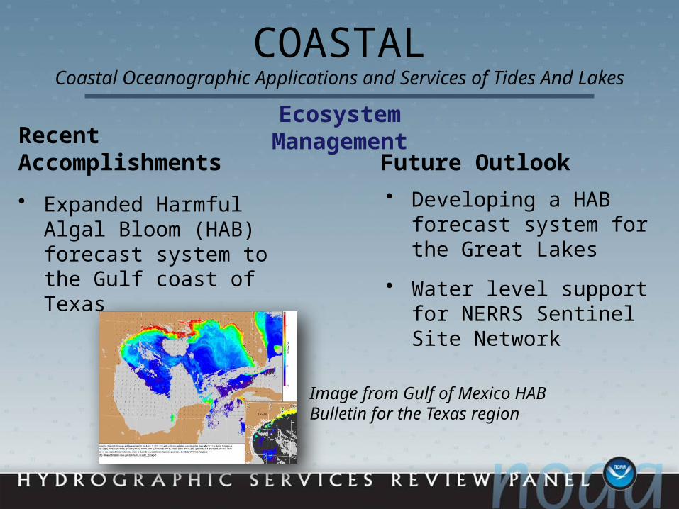
COASTALCoastal Oceanographic Applications and Services of Tides And
Lakes
Recent Accomplishments
• Expanded Harmful Algal Bloom (HAB) forecast system to the Gulf coast of Texas
Future Outlook
• Developing a HAB forecast system for the Great Lakes
• Water level support for NERRS Sentinel Site Network
Image from Gulf of Mexico HAB Bulletin for the Texas region
Ecosystem Management

COASTALCoastal Oceanographic Applications and Services of Tides And
Lakes
Recent Accomplishments• Provided long-term sea level
trends
• Issued a new publication, “Sea Level Variations of the United States, 1854-2006” with updated local sea level trends for 128 locations in the United States
• Worked with USACE to incorporate sea level trend guidance into coastal project planning
Future Outlook• Caribbean sea level
project in Barbuda
Climate Change

Budget
FY 2012 Proposed Operating PlanFY 2010 Enacted
FY 2011Annualize
dContinuingResolution
FY 2012Estimat
e
Tide & Current Data
Tide & Current Data Base 33,078 32,729 28,979
PORTS® Operation and Maintenance [3,800] 0 0
Coastal Tidal Gauges 600 0 0
Total, Tide & Current Data 33,678 32,729 28,979

Performance Metrics
Corporate Performance MeasureFY2010 FY2011 FY2012
Percent of top 175 US Seaports with access to full suite of NOAA Navigation Products and Services*
65% 67% 70%
* Tracks access to updated ENCs, shoreline, tidal current predictions, Vdatum models, real-time data
Establish new PORTS (New London) Conduct tidal current surveys (Al,
HI, MA) Publish Annual Tide and Tidal
Current Prediction Tables New Operational Forecast Models
(Tampa)
Publish local sea level trends for 159 global sea level stations
Collect water level data at 5 Arctic locations
Complete technical report on Barrow, AK water level project
CO-OPS FY2011 Milestones

Questions