Next-Generation Model Development for NOAA regional and global · Stan Benjamin Chief, Assimilation...
22
Next-Generation Model Development for NOAA – regional and global Stan Benjamin Chief, Assimilation and Modeling Branch NOAA Earth System Research Lab, Global Systems Div 12h HRRR model forecast Valid 03z NOAA/ESRL 29 Nov 2012 1 AMS Board on Enterprise Commission Observed radar 03z 30 June 2012 7-day Isaac forecast track from FIM from Fri 24 Aug 18z run
Transcript of Next-Generation Model Development for NOAA regional and global · Stan Benjamin Chief, Assimilation...

Next-Generation Model Development for NOAA – regional and global
Stan Benjamin Chief, Assimilation and Modeling Branch NOAA Earth System Research Lab, Global Systems Div
12h HRRR model forecast Valid 03z
NOAA/ESRL 29 Nov 2012 1 AMS Board on Enterprise Commission
Observed radar 03z 30 June 2012
7-day Isaac forecast track from FIM from Fri 24 Aug 18z run

Improved model formulation – Better model “physics” (clouds and precipitation,
land-surface and radiation processes)
– Higher “resolution” (13-km 3-km ??)
Improved “data assimilation”
- Blending observation to get starting
“snapshot” of the atmosphere
More powerful computers
- 1015 calculations for 15 hour forecast
- Massively parallel supercomputers
- Transition to GPU/MIC technology
Ensemble forecasts for improved skill and decision making
NOAA Environmental Prediction:
Keys to forecast skill improvement
Data assimilation cycle
GPU chip
Observations

NOAA Next-Generation Model Development
RAP
HRRR
RAP - Rapid Refresh
– NOAA “situational awareness”
model for high impact weather
– New 18-hour forecast each hour
– NOAA operational – 1 May 2012
– Hourly use by National Weather
Service, Storm Prediction
Center, FAA, private sector
HRRR – High-Resolution Rapid Refresh
- NOAA premier thunderstorm
guidance model
- New 15-h forecast each hour
- Real-time experimental on
ESRL supercomputer
- Open ftp access

NOAA Next-Generation Tornadic thunderstorm
forecast from coupled RAP / HRRR system
Radar
observed
storms
HRRR
storms
9-h forecast

NOAA Next-Generation RAP / HRRR system
Potential tornado track indicator
1 hr Max Updraft Helicity
HRRR
storms
9-h forecast
HRRR
9-h forecast

NOAA Next-Generation RAP / HRRR system
improvement from previous model
Tuscaloosa, AL
tornado outbreak
Old model -- 13km RUC
9-h forecast
5 PM CDT
27 April 2011
New model –
3km HRRR
9-h forecast
5 PM CDT
27 April 2011 Radar
observed
storms

NOAA Next-Generation RAP / HRRR system
forecast of mid-Atlantic derecho
Composite Reflectivity (dBZ)
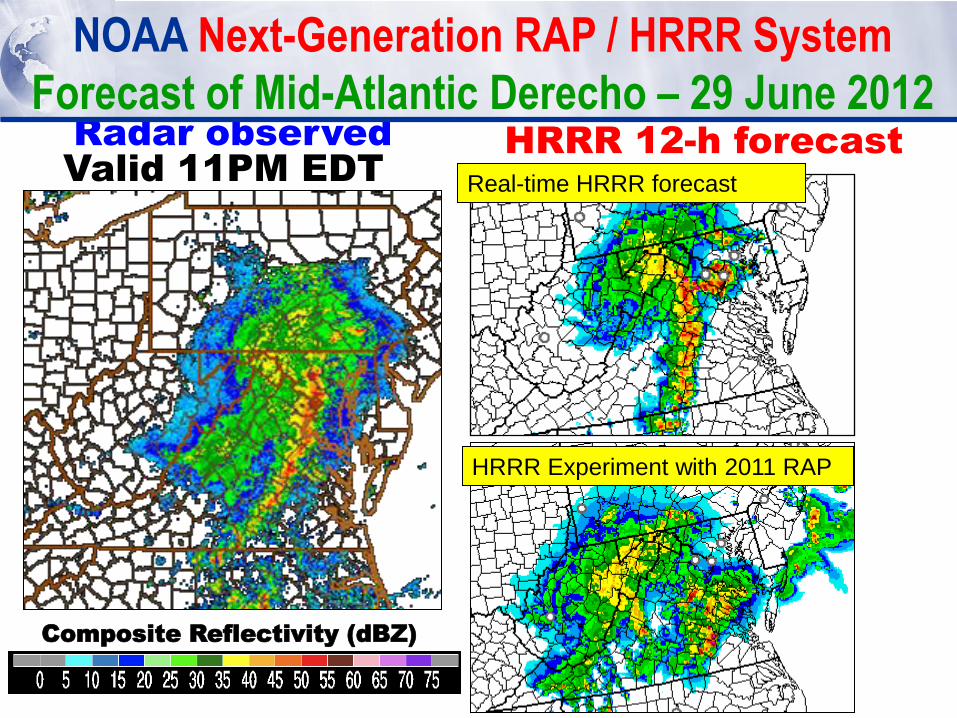
Radar observed HRRR 12-h forecast
Composite Reflectivity (dBZ)
NOAA Next-Generation RAP / HRRR System
Forecast of Mid-Atlantic Derecho – 29 June 2012
Valid 11PM EDT Real-time HRRR forecast
HRRR Experiment with 2011 RAP
9
‘Mostly’ Satellite +Radar
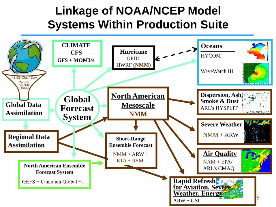
North American
Mesoscale NMM
North American Ensemble
Forecast System
Global Forecast System
Rapid Refresh for Aviation, Severe Weather, Energy ARW + GSI
CLIMATE
CFS
~3.5B Obs / Day
GFS + MOM3/4
Global Data
Assimilation
Air Quality
NMM + ARW
Dispersion, Ash, Smoke & Dust ARL’s HYSPLIT
Severe Weather
Oceans
HYCOM
WaveWatch III
NAM + EPA/
ARL’s CMAQ
Hurricane GFDL
HWRF (NMM)
Regional Data
Assimilation
NMM + ARW +
ETA + RSM
GEFS + Canadian Global +…
Short-Range
Ensemble Forecast
Linkage of NOAA/NCEP Model
Systems Within Production Suite
10
‘Mostly’ Satellite +Radar
North American
Rapid Refresh Ens (NARRE) NMM, ARW
North American Ensemble
Forecast System
Global Forecast System
HRRR for Aviation, Severe Weather, Energy ARW + GSI
CLIMATE
CFS
~3.5B Obs / Day
GFS + MOM3/4
Global Data
Assimilation
Air Quality
NMM + ARW
Dispersion, Ash, Smoke & Dust ARL’s HYSPLIT
Severe Weather
Global Coupled
ocean iHYCOM /
atmos FIM
NAM + EPA/
ARL’s CMAQ
Hurricane GFDL
HWRF (NMM)
ESRL/NCEP
Regional Data
Assim w/ radar NMM + ARW +
ETA + RSM
GEFS + Canadian Global
+FIM +NMMB
Short-Range
Ensemble Forecast
Key research efforts toward possible
future NOAA/NCEP Model Systems
FIM (GFS,
NMMB)
CFSv3,
FIM/iHYCO
M
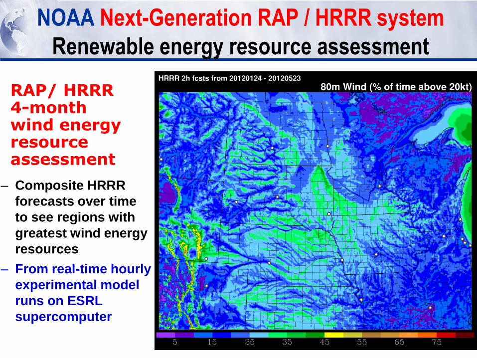
NOAA Next-Generation RAP / HRRR system
Renewable energy resource assessment
RAP/ HRRR 4-month wind energy resource assessment
– Composite HRRR
forecasts over time
to see regions with
greatest wind energy
resources
– From real-time hourly
experimental model
runs on ESRL
supercomputer

NOAA Environmental Predictions:
Technological innovation to serve our nation
Crucial need for (and use of) NOAA environmental predictions – Saving lives
tornadoes, floods, winter storms
– Providing accurate forecasts to U.S. citizens
hourly RAP / HRRR use by National Weather
Service forecasters, heavy use by private entities
– Ensuring safe and efficient travel
air traffic routing, forecasts for aviation hazards
– Promoting more efficient use energy resources
assessing renewable energy resources, forecasting ramp events
ESRL Research / innovation producing rapid advancements in forecast skill
- Improvements in model and “data assimilation” science
- Research to move rapidly to new computer technology
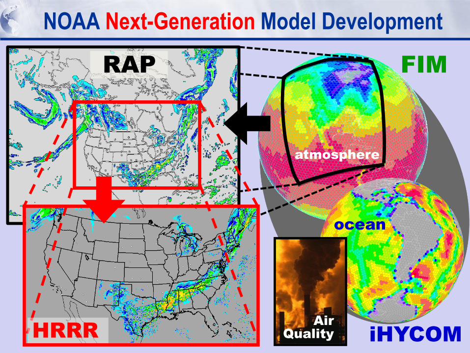
NOAA Next-Generation Model Development
RAP
HRRR
FIM
iHYCOM
Air
Quality
atmosphere
ocean
Air
Quality
NOAA Next-Generation Model Development
FIM
iHYCOM
Air
Quality
atmosphere
ocean iHYCOM – Icosahedral Hybrid Coordinate Ocean Model
- Matched grid design to FIM
for coupled ocean- atmosphere
prediction system
- Experimental
testing at ESRL
FIM – Flow-following finite volume Icosahedral Model
– “soccer-ball” grid design for
uniform grid spacing
– “Isentropic” (flow-following)
vertical coordinate
– New 10-day forecast twice daily
– Real-time experimental at ESRL
Atmospheric
chemistry
capability for
FIM, RAP, HRRR

Flow-following-
finite-volume
Icosahedral
Model FIM
X-section location
Temp at lowest level
FIM9
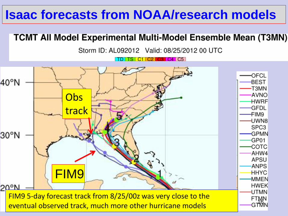
Isaac forecasts from NOAA/research models
16 FIM9 5-day forecast track from 8/25/00z was very close to the eventual observed track, much more other hurricane models
Obs track

Full 2012 track errors – Atlantic + E.Pacific basins
17
HWRF -27-9-3km
GFS operational – 27km
FIM -15km
ECMWF operational – 18km
Trac
k Er
ror
(Mile
s)
12h 24h 36h 48h 72h 96h 120h
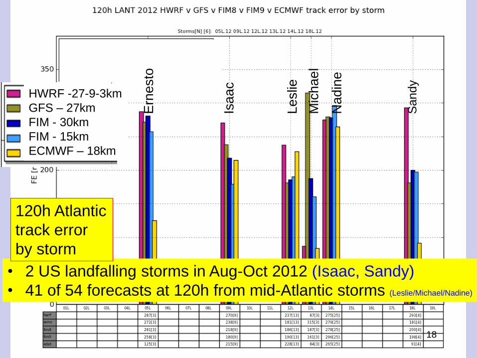
• 2 US landfalling storms in Aug-Oct 2012 (Isaac, Sandy)
• 41 of 54 forecasts at 120h from mid-Atlantic storms (Leslie/Michael/Nadine)
120h Atlantic
track error
by storm
18
HWRF -27-9-3km
GFS – 27km
FIM - 30km
FIM - 15km
ECMWF – 18km E
rne
sto
Isa
ac
Le
slie
M
ichae
l N
ad
ine
S
and
y

HFIP
ESRL-DA
Sandy – initial time 25 Oct 00z
19
Experimental NOAA
data assimilation
produced much
improved 5-day
Sandy forecast
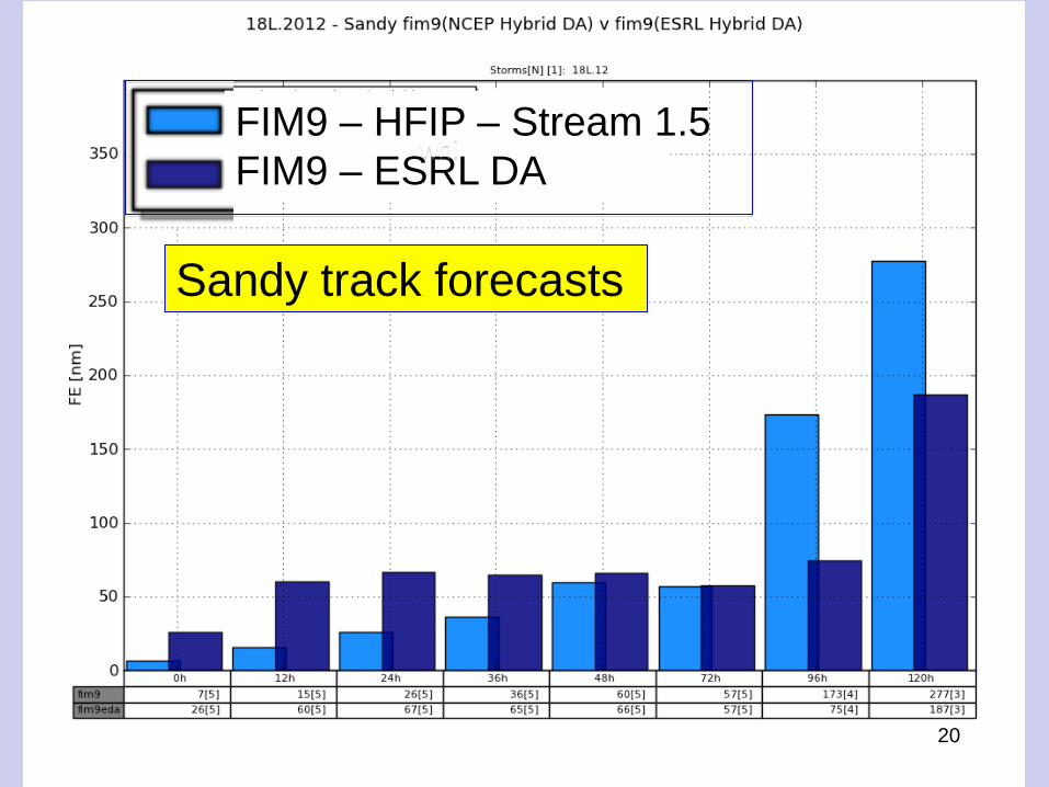
FIM9 – HFIP – Stream 1.5
FIM9 – ESRL DA whi
Sandy track forecasts
20

• Current – 1 computer running HRRR – first cut at “research regular” – NOAA/ESRL – Boulder
– Current reliability: 97% for last 12h months (allowing up to 3h gaps)
• 2013-14 – 2 computers running HRRR – interim solution – better “research regular” – Boulder, CO – computer 1 (jet)
– Fairmont, WV – computer 2 (zeus)
– Expected reliability to increase further to 98.5-99% via coordination of downtimes for Boulder vs. Fairmont computers
• 2015+ – NCEP running HRRR – NOAA/NCEP computing budget will not allow HRRR before
2015
• Conclusion: Interim HRRR computing for 2013-15 on 2 sites to provide “research regular” HRRR from NOAA for NWS, FAA, DOE/energy users
HRRR Transition to NCEP
21
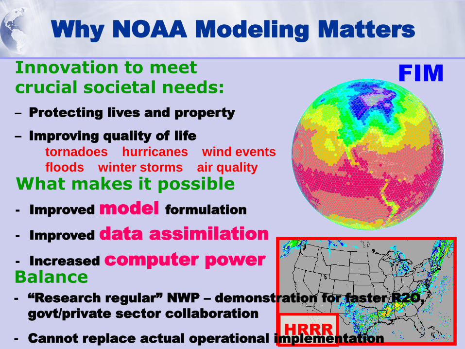
Why NOAA Modeling Matters
Innovation to meet crucial societal needs:
– Protecting lives and property
– Improving quality of life
tornadoes hurricanes wind events
floods winter storms air quality
What makes it possible
- Improved model formulation
- Improved data assimilation
- Increased computer power
HRRR
FIM
Balance - “Research regular” NWP – demonstration for faster R2O,
govt/private sector collaboration
- Cannot replace actual operational implementation