NEW YORK’S NATURAL WONDERS
16
340 Chapter 15 Landscapes NEW YORK’S NATURAL WONDERS New York is not one of the largest states of the United States, nor does it have any large national parks to rival Yosemite or the Grand Canyon. But nearly every part of the state has unique and beautiful natural wonders. No matter where you live in New York, inspiring features of geologic in- terest are no more than an hour or two away. For example, Niagara Falls is a broad sweep of thundering water that carries the outflow of four of the world’s largest freshwater lakes over a 60-meter plunge. Other spectacular waterfalls include Taughannock Falls north of Ithaca and Kaaterskill Falls at the eastern margin of the Catskills. The beaches of Long Island offer miles of white sand and pounding surf. And the freshwater beaches in the Finger Lakes and the Adirondack Mountains are famous for their scenic and recreational value. The Genesee River Gorge south of Rochester has impressive cliffs hundreds of meters high. Other gorges in the southern Finger Lakes region and along the Ausable River in the Eastern Adirondacks provide equally impressive experiences with their varied erosional forms.
Transcript of NEW YORK’S NATURAL WONDERS
340
Chapter 15Landscapes
NEW YORK’S NATURAL WONDERS
New York is not one of the largest states of the UnitedStates, nor does it have any large national parks to rivalYosemite or the Grand Canyon. But nearly every part of thestate has unique and beautiful natural wonders. No matterwhere you live in New York, inspiring features of geologic in-terest are no more than an hour or two away.
For example, Niagara Falls is a broad sweep of thunderingwater that carries the outflow of four of the world’s largestfreshwater lakes over a 60-meter plunge. Other spectacularwaterfalls include Taughannock Falls north of Ithaca andKaaterskill Falls at the eastern margin of the Catskills.
The beaches of Long Island offer miles of white sandand pounding surf. And the freshwater beaches in the FingerLakes and the Adirondack Mountains are famous for theirscenic and recreational value. The Genesee River Gorgesouth of Rochester has impressive cliffs hundreds of metershigh. Other gorges in the southern Finger Lakes region andalong the Ausable River in the Eastern Adirondacks provideequally impressive experiences with their varied erosionalforms.
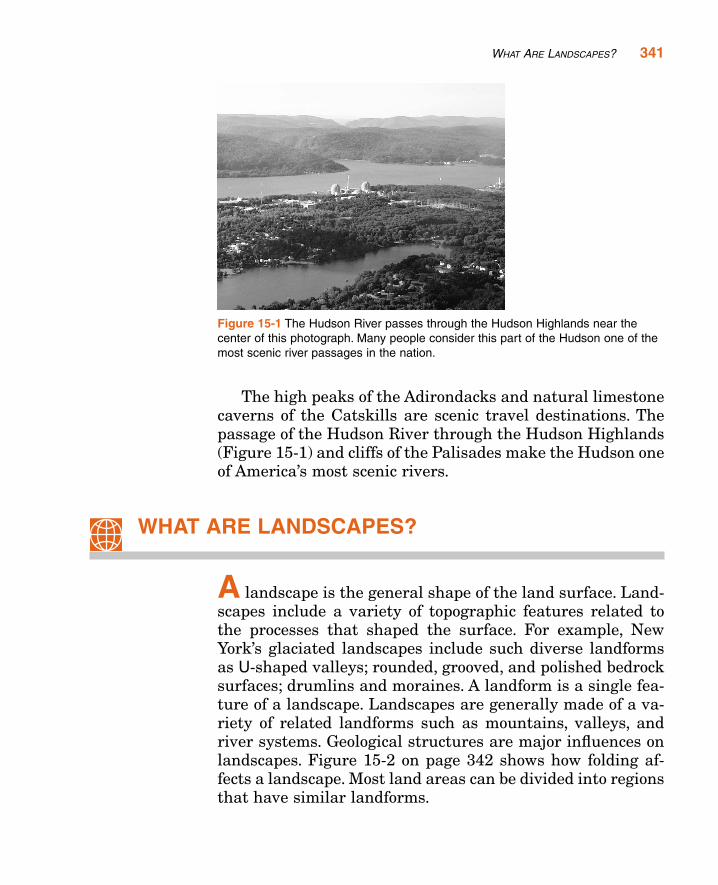
The high peaks of the Adirondacks and natural limestonecaverns of the Catskills are scenic travel destinations. Thepassage of the Hudson River through the Hudson Highlands(Figure 15-1) and cliffs of the Palisades make the Hudson oneof America’s most scenic rivers.
WHAT ARE LANDSCAPES?
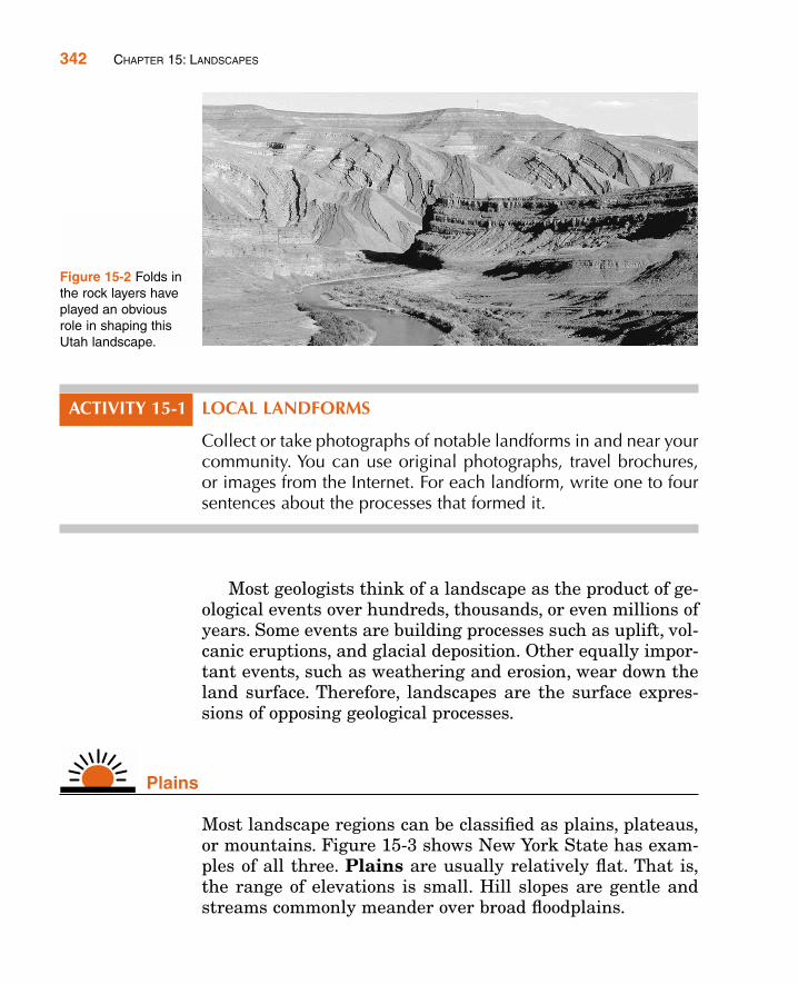
A landscape is the general shape of the land surface. Land-scapes include a variety of topographic features related tothe processes that shaped the surface. For example, NewYork’s glaciated landscapes include such diverse landformsas U-shaped valleys; rounded, grooved, and polished bedrocksurfaces; drumlins and moraines. A landform is a single fea-ture of a landscape. Landscapes are generally made of a va-riety of related landforms such as mountains, valleys, andriver systems. Geological structures are major influences onlandscapes. Figure 15-2 on page 342 shows how folding af-fects a landscape. Most land areas can be divided into regionsthat have similar landforms.
WHAT ARE LANDSCAPES? 341
Figure 15-1 The Hudson River passes through the Hudson Highlands near thecenter of this photograph. Many people consider this part of the Hudson one of themost scenic river passages in the nation.
ACTIVITY 15-1 LOCAL LANDFORMS
Collect or take photographs of notable landforms in and near yourcommunity. You can use original photographs, travel brochures,or images from the Internet. For each landform, write one to foursentences about the processes that formed it.
Most geologists think of a landscape as the product of ge-ological events over hundreds, thousands, or even millions ofyears. Some events are building processes such as uplift, vol-canic eruptions, and glacial deposition. Other equally impor-tant events, such as weathering and erosion, wear down theland surface. Therefore, landscapes are the surface expres-sions of opposing geological processes.
Plains
Most landscape regions can be classified as plains, plateaus,or mountains. Figure 15-3 shows New York State has exam-ples of all three. Plains are usually relatively flat. That is,the range of elevations is small. Hill slopes are gentle andstreams commonly meander over broad floodplains.
342 CHAPTER 15: LANDSCAPES
Figure 15-2 Folds inthe rock layers haveplayed an obviousrole in shaping thisUtah landscape.
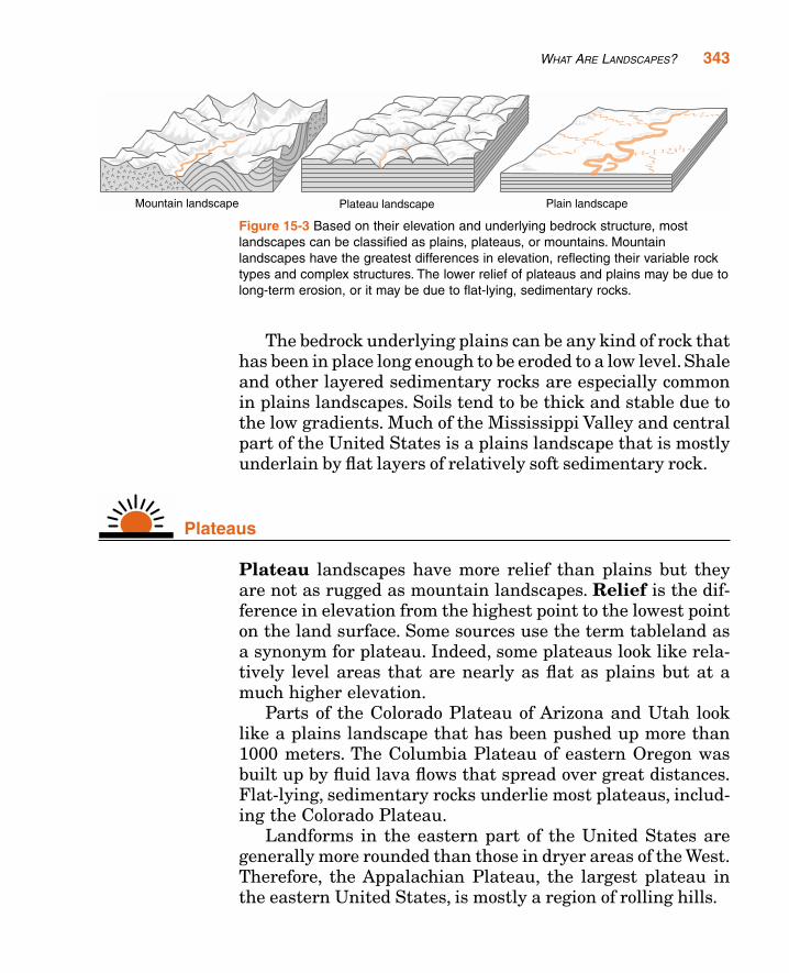
The bedrock underlying plains can be any kind of rock thathas been in place long enough to be eroded to a low level. Shaleand other layered sedimentary rocks are especially commonin plains landscapes. Soils tend to be thick and stable due tothe low gradients. Much of the Mississippi Valley and centralpart of the United States is a plains landscape that is mostlyunderlain by flat layers of relatively soft sedimentary rock.
Plateaus
Plateau landscapes have more relief than plains but theyare not as rugged as mountain landscapes. Relief is the dif-ference in elevation from the highest point to the lowest pointon the land surface. Some sources use the term tableland asa synonym for plateau. Indeed, some plateaus look like rela-tively level areas that are nearly as flat as plains but at amuch higher elevation.
Parts of the Colorado Plateau of Arizona and Utah looklike a plains landscape that has been pushed up more than1000 meters. The Columbia Plateau of eastern Oregon wasbuilt up by fluid lava flows that spread over great distances.Flat-lying, sedimentary rocks underlie most plateaus, includ-ing the Colorado Plateau.
Landforms in the eastern part of the United States aregenerally more rounded than those in dryer areas of the West.Therefore, the Appalachian Plateau, the largest plateau inthe eastern United States, is mostly a region of rolling hills.
WHAT ARE LANDSCAPES? 343
Figure 15-3 Based on their elevation and underlying bedrock structure, mostlandscapes can be classified as plains, plateaus, or mountains. Mountainlandscapes have the greatest differences in elevation, reflecting their variable rocktypes and complex structures. The lower relief of plateaus and plains may be due tolong-term erosion, or it may be due to flat-lying, sedimentary rocks.
Mountains
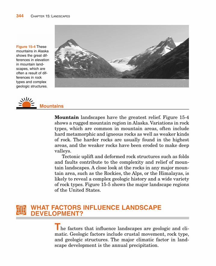
Mountain landscapes have the greatest relief. Figure 15-4shows a rugged mountain region in Alaska. Variations in rocktypes, which are common in mountain areas, often includehard metamorphic and igneous rocks as well as weaker kindsof rock. The harder rocks are usually found in the highestareas, and the weaker rocks have been eroded to make deepvalleys.
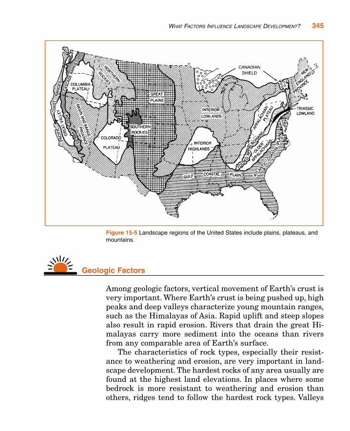
Tectonic uplift and deformed rock structures such as foldsand faults contribute to the complexity and relief of moun-tain landscapes. A close look at the rocks in any major moun-tain area, such as the Rockies, the Alps, or the Himalayas, islikely to reveal a complex geologic history and a wide varietyof rock types. Figure 15-5 shows the major landscape regionsof the United States.
WHAT FACTORS INFLUENCE LANDSCAPEDEVELOPMENT?
The factors that influence landscapes are geologic and cli-matic. Geologic factors include crustal movement, rock type,and geologic structures. The major climatic factor in land-scape development is the annual precipitation.
344 CHAPTER 15: LANDSCAPES
Figure 15-4 Thesemountains in Alaskashows the great dif-ferences in elevationin mountain land-scapes, which areoften a result of dif-ferences in rocktypes and complexgeologic structures.
Geologic Factors
Among geologic factors, vertical movement of Earth’s crust isvery important. Where Earth’s crust is being pushed up, highpeaks and deep valleys characterize young mountain ranges,such as the Himalayas of Asia. Rapid uplift and steep slopesalso result in rapid erosion. Rivers that drain the great Hi-malayas carry more sediment into the oceans than riversfrom any comparable area of Earth’s surface.
The characteristics of rock types, especially their resist-ance to weathering and erosion, are very important in land-scape development. The hardest rocks of any area usually arefound at the highest land elevations. In places where somebedrock is more resistant to weathering and erosion thanothers, ridges tend to follow the hardest rock types. Valleys
WHAT FACTORS INFLUENCE LANDSCAPE DEVELOPMENT? 345
Figure 15-5 Landscape regions of the United States include plains, plateaus, andmountains.
346 CHAPTER 15: LANDSCAPES
in these areas generally follow the softer and/or fracturedrock.
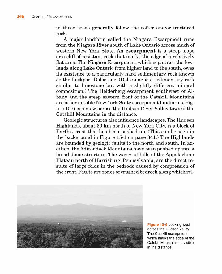
A major landform called the Niagara Escarpment runsfrom the Niagara River south of Lake Ontario across much ofwestern New York State. An escarpment is a steep slopeor a cliff of resistant rock that marks the edge of a relativelyflat area. The Niagara Escarpment, which separates the low-lands along Lake Ontario from higher land to the south, owesits existence to a particularly hard sedimentary rock knownas the Lockport Dolostone. (Dolostone is a sedimentary rocksimilar to limestone but with a slightly different mineralcomposition.) The Helderberg escarpment southwest of Al-bany and the steep eastern front of the Catskill Mountainsare other notable New York State escarpment landforms. Fig-ure 15-6 is a view across the Hudson River Valley toward theCatskill Mountains in the distance.
Geologic structures also influence landscapes.The HudsonHighlands, about 30 km north of New York City, is a block ofEarth’s crust that has been pushed up. (This can be seen inthe background in Figure 15-1 on page 341.) The Highlandsare bounded by geologic faults to the north and south. In ad-dition, the Adirondack Mountains have been pushed up into abroad dome structure. The waves of hills of the AppalachianPlateau north of Harrisburg, Pennsylvania, are the direct re-sults of large folds in the bedrock caused by compression ofthe crust. Faults are zones of crushed bedrock along which rel-
Figure 15-6 Looking westacross the Hudson Valley.The Catskill escarpment,which marks the edge of theCatskill Mountains, is visiblein the distance.
WHAT FACTORS INFLUENCE LANDSCAPE DEVELOPMENT? 347
ative movement has occurred. These lines of weakened rockinfluence the course of streams and enable rapid erosion. Thezigzag route of the Hudson River through the Hudson High-lands is probably a result of erosion along geologic faults.Faulting also controls the direction of many northeast-flowingstreams in the high peaks region of the Adirondack Moun-tains.
Climate Factors
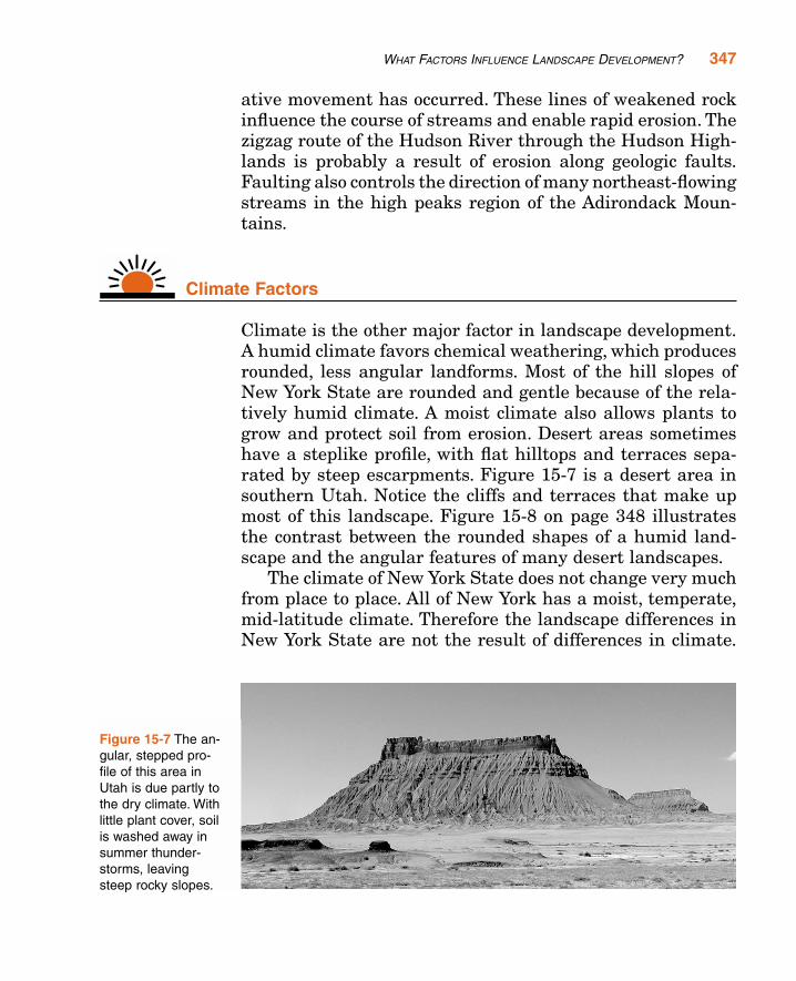
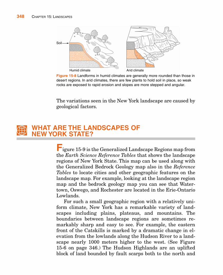
Climate is the other major factor in landscape development.A humid climate favors chemical weathering, which producesrounded, less angular landforms. Most of the hill slopes ofNew York State are rounded and gentle because of the rela-tively humid climate. A moist climate also allows plants togrow and protect soil from erosion. Desert areas sometimeshave a steplike profile, with flat hilltops and terraces sepa-rated by steep escarpments. Figure 15-7 is a desert area insouthern Utah. Notice the cliffs and terraces that make upmost of this landscape. Figure 15-8 on page 348 illustratesthe contrast between the rounded shapes of a humid land-scape and the angular features of many desert landscapes.
The climate of New York State does not change very muchfrom place to place. All of New York has a moist, temperate,mid-latitude climate. Therefore the landscape differences inNew York State are not the result of differences in climate.
Figure 15-7 The an-gular, stepped pro-file of this area inUtah is due partly tothe dry climate. Withlittle plant cover, soilis washed away insummer thunder-storms, leavingsteep rocky slopes.
The variations seen in the New York landscape are caused bygeological factors.
WHAT ARE THE LANDSCAPES OF NEW YORK STATE?
Figure 15-9 is the Generalized Landscape Regions map fromthe Earth Science Reference Tables that shows the landscaperegions of New York State. This map can be used along withthe Generalized Bedrock Geology map also in the ReferenceTables to locate cities and other geographic features on thelandscape map. For example, looking at the landscape regionmap and the bedrock geology map you can see that Water-town, Oswego, and Rochester are located in the Erie-OntarioLowlands.
For such a small geographic region with a relatively uni-form climate, New York has a remarkable variety of land-scapes including plains, plateaus, and mountains. Theboundaries between landscape regions are sometimes re-markably sharp and easy to see. For example, the easternfront of the Catskills is marked by a dramatic change in el-evation from the lowlands along the Hudson River to a land-scape nearly 1000 meters higher to the west. (See Figure15-6 on page 346.) The Hudson Highlands are an upliftedblock of land bounded by fault scarps both to the north and
348 CHAPTER 15: LANDSCAPES
Figure 15-8 Landforms in humid climates are generally more rounded than those indesert regions. In arid climates, there are few plants to hold soil in place, so weakrocks are exposed to rapid erosion and slopes are more stepped and angular.

to the south. However, the long boundary between the Al-legheny Plateau and the Erie-Ontario Lowlands in westernNew York is more subtle, and the exact position of the tran-sition is not easy to see in most places.
ACTIVITY 15-2 LANDSCAPE BOUNDARIES
If you live near a landscape boundary, draw that boundary on alocal road map. In what ways does the land look different on thetwo sides of the boundary?
WHAT ARE THE LANDSCAPES OF NEW YORK STATE? 349
Figure 15-9 The landscape regions of New York include plains, plateaus, and mountains. In addition, thereare several regions difficult to classify. Boundaries between landscape regions often follow changes inelevation and rock types.
Long Island
A tour of New York State might start at the eastern end ofLong Island where glacial moraines give this part of the is-land its split, fish-tail shape as seen on maps. Two moraines,which mark the most southerly advance of the recent conti-nental glacier, dominate Long Island. These moraines formeast-west lines of low hills on an otherwise low-lying and flatplains landscape largely composed of sandy outwash sedi-ments. Wind, longshore currents, and wave action depositand shape the sandy beaches and dunes along the southshore.
On Long Island, only the western end is hard metamor-phic bedrock visible at the surface. This is within the bound-aries of New York City, which also includes the bedrockislands of Manhattan and Staten Island as well as the Bronx,which is built on the bedrock mainland of North America.
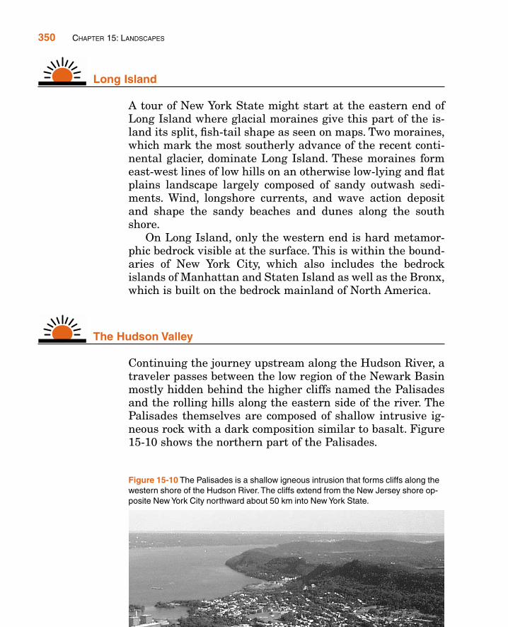
The Hudson Valley
Continuing the journey upstream along the Hudson River, atraveler passes between the low region of the Newark Basinmostly hidden behind the higher cliffs named the Palisadesand the rolling hills along the eastern side of the river. ThePalisades themselves are composed of shallow intrusive ig-neous rock with a dark composition similar to basalt. Figure15-10 shows the northern part of the Palisades.
350 CHAPTER 15: LANDSCAPES
Figure 15-10 The Palisades is a shallow igneous intrusion that forms cliffs along thewestern shore of the Hudson River. The cliffs extend from the New Jersey shore op-posite New York City northward about 50 km into New York State.

Mostly on the east side of the Hudson River, the TaconicMountains, the Hudson Highlands, and the Manhattan Prongare all underlain by very old metamorphic rock. This old rockgives them a complex landscape, but mostly without the steepslopes and high peaks of a true mountain landscape.
The Catskills-Allegheny Plateau
The Catskills rise above the western edge of the Hudson Val-ley. Although they are sometimes called the Catskill Moun-tains and they include some of the highest elevations in NewYork State, the Catskills are underlain by flat layers of sedi-mentary rock with rounded and even relatively flat summits.The Catskills are the higher, eastern end of the AlleghenyPlateau, a large region of rolling hills that extends nearly toLake Erie at the western end of the state. The AlleghenyPlateau, an extension of the Appalachian Plateau, containsthe Finger Lakes as well as other valleys deepened andU-shaped by the advancing continental glaciers.
Plains
Lakes Erie and Ontario, two of North America’s Great Lakes,are bordered by a plains landscape that includes drumlinsand other features of the ice ages. Local soils have a good mixof minerals due in part to the abundance of glacial till carriedsouth from Canada. The lakes moderate the nearby climateof this agricultural region, extending the growing season.This plains landscape extends along the St. Lawrence Riverand around the Adirondack Mountains to join the valleys ofthe Hudson and Mohawk rivers.
Tug Hill Plateau and Adirondacks
Two landscape regions remain. The Tug Hill Plateau is aremote and sparsely populated highland that receives thegreatest winter snowfalls in New York State.
WHAT ARE THE LANDSCAPES OF NEW YORK STATE? 351
The Adirondacks is New York’s best example of a truemountain landscape. The land was pushed up onto a broaddome exposing at the surface ancient metamorphic rocks thatwere formed deep underground. Faulted stream valleys con-tribute to the mountain relief. The highest point in the state,Mt. Marcy, and some of the most scenic lakes are located inthis region. Tourism is the mainstay of the economy since thearea is too rugged and cold for good farming and it is too re-mote for commerce.
ACTIVITY 15-3 LANDFORMS OF NEW YORK STATE
As a class, collect photographs from individuals, from travelbrochures, or from the Internet, and attach them at their appropri-ate place on a large wall map of New York State. Select photo-graphs that show landforms characteristic of the various landscaperegions of New York.
A similar project can be conducted collecting photographs oflandform in the United States and placing them on a map of theUnited States.
TERMS TO KNOW
escarpment mountain landscape plateaulandform plains relieflandscape
CHAPTER REVIEW QUESTIONS
1. Which kind of landscape is not likely to be underlain by flat lying sedi-mentary rocks?
(1) lowlands (3) plateaus(2) plains (4) mountains
352 CHAPTER 15: LANDSCAPES
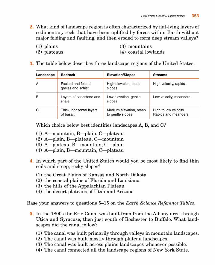
2. What kind of landscape region is often characterized by flat-lying layers ofsedimentary rock that have been uplifted by forces within Earth withoutmajor folding and faulting, and then eroded to form deep stream valleys?
(1) plains (3) mountains(2) plateaus (4) coastal lowlands
3. The table below describes three landscape regions of the United States.
Landscape Bedrock Elevation/Slopes Streams. . .
A Faulted and folded High elevation, steep High velocity, rapidsgneiss and schist slopes
B Layers of sandstone and Low elevation, gentle Low velocity, meandersshale slopes
C Thick, horizontal layers Medium elevation, steep High to low velocity, of basalt to gentle slopes Rapids and meanders
Which choice below best identifies landscapes A, B, and C?
(1) A—mountain, B—plain, C—plateau(2) A—plain, B—plateau, C—mountain(3) A—plateau, B—mountain, C—plain(4) A—plain, B—mountain, C—plateau
4. In which part of the United States would you be most likely to find thinsoils and steep, rocky slopes?
(1) the Great Plains of Kansas and North Dakota(2) the coastal plains of Florida and Louisiana(3) the hills of the Appalachian Plateau(4) the desert plateaus of Utah and Arizona
Base your answers to questions 5–15 on the Earth Science Reference Tables.
5. In the 1800s the Erie Canal was built from from the Albany area throughUtica and Syracuse, then just south of Rochester to Buffalo. What land-scapes did the canal follow?
(1) The canal was built primarily through valleys in mountain landscapes.(2) The canal was built mostly through plateau landscapes.(3) The canal was built across plains landscapes whenever possible.(4) The canal connected all the landscape regions of New York State.
CHAPTER REVIEW QUESTIONS 353
6. Within New York State, the Genesee River and the Susquehanna Riverflow mostly through which landscape region?
(1) the Hudson-Mohawk Lowlands (3) the Allegheny Plateau(2) the Atlantic Coastal Plain (4) the Adirondack Mountains
7. Tilted, metamorphosed bedrock is typically found in which New York Statelandscape region?
(1) Taconic Mountains (3) Tug Hill Plateau(2) Atlantic Coastal Plain (4) Erie-Ontario Lowlands
8. The Catskills are actually a part of what larger landscape region?
(1) the Adirondack Mountains (3) the Allegheny Plateau(2) the New England Highlands (4) the Manhattan Prong
9. What is the smallest distance from the southern boundary of the Adiron-dack Mountains landscape to the northern boundary of the AlleghenyPlateau?
(1) approximately 10 km (3) approximately 100 km(2) approximately 50 km (4) greater than 200 km
10. Which two locations are in the same New York State landscape region?
(1) Albany and Old Forge(2) Massena and Mt. Marcy(3) Binghamton and New York City(4) Jamestown and Ithaca
11. Buffalo, New York, and Plattsburgh, New York, are both located in land-scape regions classified as
(1) highlands. (3) plateaus.(2) lowlands. (4) mountains.
12. It is feared that global warming could melt the polar ice caps and causesea level to rise. Which part of New York State would most likely be floodedif this were to occur?
(1) Allegheny Plateau (3) Adirondack Mountains(2) Erie-Ontario Lowlands (4) Atlantic Coastal Plain
354 CHAPTER 15: LANDSCAPES
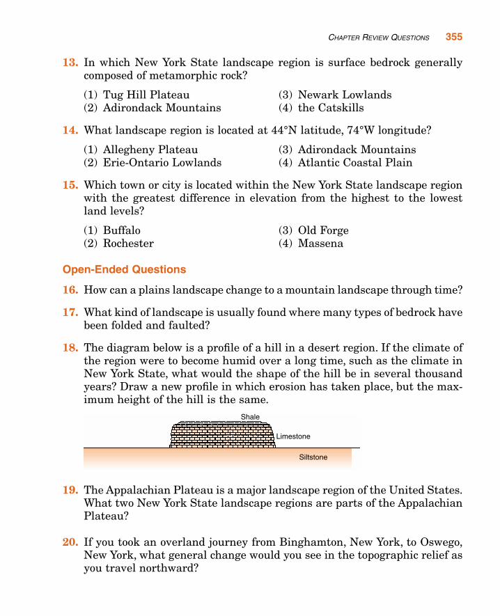
13. In which New York State landscape region is surface bedrock generallycomposed of metamorphic rock?
(1) Tug Hill Plateau (3) Newark Lowlands(2) Adirondack Mountains (4) the Catskills
14. What landscape region is located at 44°N latitude, 74°W longitude?
(1) Allegheny Plateau (3) Adirondack Mountains(2) Erie-Ontario Lowlands (4) Atlantic Coastal Plain
15. Which town or city is located within the New York State landscape regionwith the greatest difference in elevation from the highest to the lowestland levels?
(1) Buffalo (3) Old Forge(2) Rochester (4) Massena
Open-Ended Questions
16. How can a plains landscape change to a mountain landscape through time?
17. What kind of landscape is usually found where many types of bedrock havebeen folded and faulted?
18. The diagram below is a profile of a hill in a desert region. If the climate ofthe region were to become humid over a long time, such as the climate inNew York State, what would the shape of the hill be in several thousandyears? Draw a new profile in which erosion has taken place, but the max-imum height of the hill is the same.
19. The Appalachian Plateau is a major landscape region of the United States.What two New York State landscape regions are parts of the AppalachianPlateau?
20. If you took an overland journey from Binghamton, New York, to Oswego,New York, what general change would you see in the topographic relief asyou travel northward?
CHAPTER REVIEW QUESTIONS 355