New Orleans Metropolitan Inland Waterway Container ...evaccenter.lsu.edu/pub/11-06.pdfB. St. Louis...
93
Gulf Coast Research Center for Evacuation and Transportation Resiliency The LSU / UNO University Transportation Center New Orleans Metropolitan Inland Waterway Container Transport (IWCT) Feasibility Study September 2011 Final Report Stan L. Swigart / James R. Amdal / Tara Tolford Prepared by: Gulf Coast Research Center for Evacuation and Transportation Resiliency Merritt C. Becker Jr. University of New Orleans Transportation Institute New Orleans, Louisiana 70148 Prepared for: Regional Planning Commission for Jefferson, Orleans, Plaquemines, St. Bernard and St. Tammany Parishes 10 Veterans Memorial Blvd. New Orleans, Louisiana 70124 FHWA Contract No. PL-0011(034) State Project No. 736-36-0057 RPC Task A-3.11 UNO Project No. 000010000000854
Transcript of New Orleans Metropolitan Inland Waterway Container ...evaccenter.lsu.edu/pub/11-06.pdfB. St. Louis...

Gulf Coast Research Center for
Evacuation and Transportation Resiliency
The LSU / UNO University Transportation Center
New Orleans Metropolitan Inland Waterway
Container Transport (IWCT) Feasibility
Study September 2011
Final Report
Stan L. Swigart / James R. Amdal / Tara Tolford Prepared by: Gulf Coast Research Center for Evacuation and Transportation Resiliency
Merritt C. Becker Jr. University of New Orleans Transportation Institute
New Orleans, Louisiana 70148 Prepared for: Regional Planning Commission for Jefferson, Orleans, Plaquemines, St. Bernard and St. Tammany Parishes
10 Veterans Memorial Blvd.
New Orleans, Louisiana 70124
FHWA Contract No. PL-0011(034)
State Project No. 736-36-0057
RPC Task A-3.11
UNO Project No. 000010000000854

New Orleans Metropolitan Inland Waterway Container Transport Feasibility Study
Prepared for: Regional Planning Commission for Jefferson, Orleans, Plaquemines, St. Bernard and St. Tammany Parishes Final Report
FHWA Contract No. PL-0011(034), State Project No. 736-36-0057, RPC Task A-3.11, UNO Project No. 000010000000854
i Gulf Coast Research Center for Evacuation and Transportation Resiliency
Merritt C. Becker Jr. University of New Orleans Transportation Institute
September, 2011
Financial Acknowledgements
The preparation of this report has been financed in part by the Regional Planning Commission
for Jefferson, Orleans, Plaquemines, St. Bernard and St. Tammany Parishes using Federal
Highway Administration annual planning funds (PL) and by the Gulf Coast Research Center for
Evacuation and Transportation Resiliency, a University Transportation Center collaboration
between Louisiana State University and the University of New Orleans, using U.S. DOT
research funds.
Disclaimer The contents of this report reflect the views of the authors, who are solely responsible for the
facts and the accuracy of the material and information presented herein. This document is
disseminated under the sponsorship of the U.S. Department of Transportation University
Transportation Centers Program in the interest of information exchange. The U.S. Government
assumes no liability for the contents or use thereof. The contents do not necessarily reflect the
official views of the U.S. Government. This report does not constitute a standard, specification,
or regulation

New Orleans Metropolitan Inland Waterway Container Transport Feasibility Study
Prepared for: Regional Planning Commission for Jefferson, Orleans, Plaquemines, St. Bernard and St. Tammany Parishes Final Report
FHWA Contract No. PL-0011(034), State Project No. 736-36-0057, RPC Task A-3.11, UNO Project No. 000010000000854
ii Gulf Coast Research Center for Evacuation and Transportation Resiliency
Merritt C. Becker Jr. University of New Orleans Transportation Institute
September, 2011
GULF COAST RESEARCH CENTER FOR
EVACUATION AND TRANSPORTATION
RESILIENCY The Gulf Coast Research Center for Evacuation and Transportation Resiliency is a
collaborative effort between the Louisiana State University Department of Civil and
Environmental Engineering and the University of New Orleans' Department of Planning and Urban Studies. The
theme of the LSU-UNO Center is focused on Evacuation and Transportation Resiliency in an effort to address the
multitude of issues that impact transportation processes under emergency conditions such as extreme weather
conditions causing evacuation, a national emergency or other major events. This area of research also addresses the
need to develop and maintain the ability of transportation systems to economically, efficiently, and safely respond to
the changing demands that may be placed upon them.
Research The Center focuses on addressing the multitude of issues that impact transportation processes under emergency
conditions such as evacuation and other types of major events as well as the need to develop and maintain the ability
of transportation systems to economically, efficiently, and safely respond to the changing conditions and demands
that may be placed upon them. Work in this area includes the development of modeling and analysis techniques;
innovative design and control strategies; and travel demand estimation and planning methods that can be used to
predict and improve travel under periods of immediate and overwhelming demand. In addition to detailed analysis
of emergency transportation processes, The Center provides support for the broader study of transportation
resiliency. This includes work on the key components of redundant transportation systems, analysis of congestion in
relation to resiliency, impact of climate change and peak oil, provision of transportation options, and transportation
finance. The scope of the work stretches over several different modes including auto, transit, maritime, and non-
motorized
Education The educational goal of the Institute is to provide undergraduate-level education to students seeking careers in areas
of transportation that are critical to Louisiana and to the field of transportation in general with local, national and
international applications. Courses in Transportation Planning, Policy, and Land use are offered at UNO, under the
Department of Planning and Urban Studies. In addition to the program offerings at UNO, LSU offers transportation
engineering courses through its Department of Civil and Environmental Engineering. The Center also provides on-
going research opportunities for graduate students as well as annual scholarships.
Technology Transfer The LSU/UNO UTC conducts technology transfer activities in the following modes: 1) focused professional,
specialized courses, workshops and seminars for private sector entities (business and nonprofits) and government
interests, and the public on transport issues (based on the LSU-UNO activities); 2) Research symposia; transport
issues (based on the LSU-UNO activities); 3) Presentations at professional organizations; 4) Publications. The
Center sponsors the National Carless Evacuation Conference and has co-sponsored other national conferences on
active transportation


New Orleans Metropolitan Inland Waterway Container Transport Feasibility Study
Prepared for: Regional Planning Commission for Jefferson, Orleans, Plaquemines, St. Bernard and St. Tammany Parishes Final Report
FHWA Contract No. PL-0011(034), State Project No. 736-36-0057, RPC Task A-3.11, UNO Project No. 000010000000854
iv Gulf Coast Research Center for Evacuation and Transportation Resiliency
Merritt C. Becker Jr. University of New Orleans Transportation Institute
September, 2011


New Orleans Metropolitan Inland Waterway Container Transport Feasibility Study
Prepared for: Regional Planning Commission for Jefferson, Orleans, Plaquemines, St. Bernard and St. Tammany Parishes Final Report
FHWA Contract No. PL-0011(034), State Project No. 736-36-0057, RPC Task A-3.11, UNO Project No. 000010000000854
vi Gulf Coast Research Center for Evacuation and Transportation Resiliency
Merritt C. Becker Jr. University of New Orleans Transportation Institute
September, 2011
We would like to thank the following individuals who provided valuable information to the research
team and actively participated in the development of this project:
John L. Pennison General Manager Plaquemines Parish Port and Harbor District
Plaquemines Parish, Louisiana
Bobby Landry Director of Marketing Port of New Orleans
New Orleans, Louisiana
Linda Prudhomme Director of Port of South Louisiana
Business Development Reserve, Louisiana
Greg Johnson Director of Port of Greater Baton Rouge
Business Development Port Allen, Louisiana
Michael Moyer Operations Manager International Port of Memphis
Memphis, Tennessee
Lanny Chalk Terminal Manager Fullen Dock and Warehouse
Memphis, Tennessee
Dan Overby Executive Director SEMO Port
Scott City, Missouri
Dennis Wilmsmeyer Executive Director Tri-City Regional Port District
Granite City, Illinois
Steve Jeager Executive Director TRANSPORT
Peoria, Illinois
Rich Couch President Couch Lines
LaPorte, Texas
Lynn Clarkson President Clarkson Grain Company, Inc.
Cerro Gordo, Illinois
Craig Huss Senior VP Archer Daniels Midland (ADM)
Decatur, Illinois
Royce Wilkin President ARTCO
Decatur, Illinois
Mark Schweitzer Managing Director ADM - Intermodal and Container Freight
Decatur, Illinois
New Orleans Metropolitan Inland Waterway Container Transport Feasibility Study
Prepared for: Regional Planning Commission for Jefferson, Orleans, Plaquemines, St. Bernard and St. Tammany Parishes Final Report
FHWA Contract No. PL-0011(034), State Project No. 736-36-0057, RPC Task A-3.11, UNO Project No. 000010000000854
vii Gulf Coast Research Center for Evacuation and Transportation Resiliency
Merritt C. Becker Jr. University of New Orleans Transportation Institute
September, 2011
Contents
List of Figures _______________________________________________________________ ix
List of Tables ________________________________________________________________ ix
Executive Summary __________________________________________________________ 1
Abstract ____________________________________________________________________ 7
Preface _____________________________________________________________________ 8
Section 1. Container Transportation: An Overview ________________________________ 9
A. History _______________________________________________________________ 9
B. Global Container Growth Projections ____________________________________ 10
C. U.S. Container Growth Outlook and the Gulf Coast Region __________________ 11
Section 2. Inland Waterway Container Transportation (IWCT) _________________ 12
A. A Literature Review ___________________________________________________ 13
Inland Waterway Container Transport: Background and Current Status ______ 14
Opportunities and Advantages of Inland Waterway Container Transport ______ 15
Challenges and Limitations of IWCT _____________________________________ 16
IWCT: Lessons from Europe ____________________________________________ 18
Policy Implications and Technical Needs of U.S. IWCT Development __________ 20
B. European Inland Waterway Container Service _____________________________ 21
The Rhine Delta_______________________________________________________ 22
Historical Growth in European IWCT (1975 – Present) _____________________ 24
Operating Profile _____________________________________________________ 27
Current Policy Initiatives _______________________________________________ 28
C. United States Inland Waterway Container Transport _______________________ 31
United States IWCT (1975 – Present) _____________________________________ 32
Operating Context ____________________________________________________ 36
Current Policy Initiatives _______________________________________________ 37
Section 3: Asian Container Trade Implications for U.S. Ports ______________________ 38
A. Mini-Landbridge versus All-Water_______________________________________ 38
B. Panama Canal Expansion Implications for East and Gulf Coast Ports _________ 42
C. Implications for Inland River Container Transport _________________________ 43
Section 4. External Factors Affecting IWCT’s Future _____________________________ 43
A. Operating Costs _______________________________________________________ 44
Infrastructure Maintenance Costs _______________________________________ 44
Fuel Costs ____________________________________________________________ 45
Time Costs: Congestion and Debottlenecking ______________________________ 46
B. Policy, Economic and Resiliency Factors __________________________________ 46
Environmental Policy _____________________________________________________ 46

New Orleans Metropolitan Inland Waterway Container Transport Feasibility Study
Prepared for: Regional Planning Commission for Jefferson, Orleans, Plaquemines, St. Bernard and St. Tammany Parishes Final Report
FHWA Contract No. PL-0011(034), State Project No. 736-36-0057, RPC Task A-3.11, UNO Project No. 000010000000854
viii Gulf Coast Research Center for Evacuation and Transportation Resiliency
Merritt C. Becker Jr. University of New Orleans Transportation Institute
September, 2011
Cargo Volumes and Overweight Factors __________________________________ 49
Freight Transportation Resilience________________________________________ 51
Section 5. Regional Overview of Selected Gateway and Inland Waterway Terminals ___ 52
A. The Louisiana International Gulf Transfer Terminal _______________________ 56
B. SeaPoint LLC (SPLLC) ________________________________________________ 58
C. Plaquemines Parish Port, Harbor and Terminal District _____________________ 58
D. Port of New Orleans Napoleon Avenue Container Terminal (NACT) __________ 61
E. Port of South Louisiana (PSL) ___________________________________________ 61
Reserve, Louisiana _______________________________________________________ 61
F. Port of Greater Baton Rouge (PGBR) ____________________________________ 63
G. International Port of Memphis (POM) ____________________________________ 65
H. Americas Central Port –Tri-City Regional Port District _____________________ 69
Section 6. Freight Transportation Profiles of Memphis and St. Louis ________________ 72
A. Memphis – America’s Distribution Center ________________________________ 72
B. St. Louis Metro Area __________________________________________________ 76
Section 7. Findings & Conclusions _____________________________________________ 78
Section 8: Recommendations _________________________________________________ 80
References _________________________________________________________________ 81

New Orleans Metropolitan Inland Waterway Container Transport Feasibility Study
Prepared for: Regional Planning Commission for Jefferson, Orleans, Plaquemines, St. Bernard and St. Tammany Parishes Final Report
FHWA Contract No. PL-0011(034), State Project No. 736-36-0057, RPC Task A-3.11, UNO Project No. 000010000000854
ix Gulf Coast Research Center for Evacuation and Transportation Resiliency
Merritt C. Becker Jr. University of New Orleans Transportation Institute
September, 2011
List of Figures
Figure 1- Container Activity Growth Rates vis a vis World GDP _______________________________________ 10 Figure 2- Container Growth Rates- Total U.S. versus Gulf Coast _______________________________________ 11 Figure 3 Inland river container transport flows in Europe ____________________________________________ 22 Figure 4 : Rhine Delta Trade Sections _____________________________________________________________ 23 Figure 5 TEU throughputs via Rotterdam, Antwerp and the Rhine Delta ________________________________ 26 Figure 6 Modal Split at the Ports of Rotterdam and Antwerp __________________________________________ 27 Figure 7“Jowi” Class Next to a Conventional Inland Container Vessel __________________________________ 27 Figure 8 Conventional Inland Container Vessel _____________________________________________________ 27 Figure 9 Mississippi Valley Waterway System ______________________________________________________ 32 Figure 10 Full Container Loads on the Columbia/Snake River 2000-2010 ________________________________ 36 Figure 11 Major Corridors and Container Ports in the United States Reaching Mid-America _______________ 42 Figure 12 Gateway Port Locations ________________________________________________________________ 55 Figure 13 Conceptual Rendering LIGTT ___________________________________________________________ 56 Figure 14 LIGTT Distribution Concept ____________________________________________________________ 57 Figure 15 Conceptual Rendering - SeaPoint ________________________________________________________ 58 Figure 16: Kinder Morgan Marine Terminal _______________________________________________________ 59 Figure 17 Napoleon Avenue Container Facility ______________________________________________________ 61 Figure 18 PSL Barge Fleeting and Midstream Operations _____________________________________________ 62 Figure 19 GlobalPlex Intermodal Terminal _________________________________________________________ 62 Figure 20 Osprey Lines Locking Through at Port Allen Locks _________________________________________ 63 Figure 21: Inland Port Locations _________________________________________________________________ 64 Figure 22 Frank C. Pigeon Industrial Park _________________________________________________________ 65 Figure 23 Fullen Dock-ramp _____________________________________________________________________ 67 Figure 24 Fullen Dock Floating Barge _____________________________________________________________ 67 Figure 25 Osprey Lines Largest Tow at Fullen Dock _________________________________________________ 68 Figure 26 America’s Central Port _________________________________________________________________ 70 Figure 27 Conceptual Rendering of South Harbor Facility Improvement Project _________________________ 71 Figure 28 Memphis Regional Freight Infrastructure Plan Study Area ___________________________________ 72 Figure 29 International Port of Memphis ___________________________________________________________ 74
List of Tables Table 1: Fuel Usage Comparison: Barge, Rail, and Truck _____________________________________________ 15 Table 2: Inland River Container Services __________________________________________________________ 34 Table 3: Comparison of Fuel Prices and Line Haul Costs by Mode (in 2008 dollars) _______________________ 45 Table 4: Emissions by Transportation Mode (Pollutants in lbs produced per ton of cargo per 1000 miles) ____ 476 Table 5: Louisiana 8-Hour Ozone standard monitor levels ____________________________________________ 49 Table 6: Mississippi River Rail Crossings from New Orleans to St. Louis ________________________________ 52 Table 7: Selected Gateway and Inland Port attributes ________________________________________________ 54 Table 8: Total International Land and Water Trade in Memphis Region, 2007 ___________________________ 73 Table 9: Total International Land and Water Trade in the Memphis Region by Mode 2007 _________________ 75 Table 10: Total International Land and Water imports in the Memphis Region by Mode 2007 ______________ 75 Table 11: Total International Land and Water Exports in the Memphis Region by Mode 2007 ______________ 75 Table 12: Percent of Imports and Exports Containerized by Mode 2007 _________________________________ 76

New Orleans Metropolitan Inland Waterway Container Transport Feasibility Study
Prepared for: Regional Planning Commission for Jefferson, Orleans, Plaquemines, St. Bernard and St. Tammany Parishes Final Report
FHWA Contract No. PL-0011(034), State Project No. 736-36-0057, RPC Task A-3.11, UNO Project No. 000010000000854
1 Gulf Coast Research Center for Evacuation and Transportation Resiliency
Merritt C. Becker Jr. University of New Orleans Transportation Institute
September, 2011
Executive Summary Worldwide conditions now exist that could create a positive environment for new transportation
modes to serve the Gulf Coast, the New Orleans region, and the entire Mississippi River corridor.
Specifically, Inland Waterway Container Transport (IWCT), anchored by a new container “gateway”
in the lower section of the Mississippi River, could radically alter international freight movements
within the United States. Given the state of the world’s recovering economy, the rising cost of fuel,
and ever-evolving international trade lanes, the Regional Planning Commission (RPC), in
partnership with the Gulf Coast Center for Evacuation and Transportation Resiliency, questioned
what impacts these collective forces could have on the existing landside infrastructure supporting
international freight movements along both the lower and upper Mississippi River. Although no one
can predict the future, with any degree of certainty, the project sponsors wanted to investigate
probable futures caused by these dynamics on the movement of international trade through the
greater New Orleans region and along the entire Mississippi River corridor. More specifically, RPC
wanted to learn what would be needed within their jurisdiction if IWCT emerges as a viable form of
transportation in the United States.
This project assumes the following conditions:
Cargo flows will change due to the expansion of the Panama Canal. The magnitude of the
impact on Gulf shipping lanes and ports is speculative.
An increased volume of inbound containers, estimated at a minimum of one million TEUs,
through a Mississippi River Gateway Port, could influence a modal shift to IWCT. This would make
the Mississippi River a viable National Marine Highway able to service the transport of
containerized cargoes to major inland distribution hubs and Mid-American consumption markets.
Inland Waterway Container Transport will be supported by federal programs designed to
incentivize and influence modal shifts from land to water.
IWCT can create a number of positive outcomes for the Lower Mississippi River region and the
entire Mississippi River trade corridor. These include the following:
Positive economic impacts in the regional maritime sector such as ship design and
construction activities utilizing regional shipbuilding facilities.

New Orleans Metropolitan Inland Waterway Container Transport Feasibility Study
Prepared for: Regional Planning Commission for Jefferson, Orleans, Plaquemines, St. Bernard and St. Tammany Parishes Final Report
FHWA Contract No. PL-0011(034), State Project No. 736-36-0057, RPC Task A-3.11, UNO Project No. 000010000000854
2 Gulf Coast Research Center for Evacuation and Transportation Resiliency
Merritt C. Becker Jr. University of New Orleans Transportation Institute
September, 2011
The development of “container gateway terminals” at or near the mouth of the Mississippi
River.
New landside support infrastructure investments at upriver sites.
Diversification of regional port assets such as distribution facilities and value added services.
Existing and proposed terminals located between Southwest Pass and Baton Rouge are included
within the study scope as well as upriver inland ports serving the Mid-American consumption
markets. The upriver ports are integral parts of two major inland transportation hubs: Memphis, TN
and St. Louis, MO. These two metropolitan areas represent the largest transportation and distribution
hubs located within the portion of the Mississippi river trade corridor unimpeded by the lock system.
They also represent a diverse network of transportation systems that link to all major consumption
markets east of the Mississippi River. These areas offer a unique set of diverse transportation assets
including Class 1 railroads, interstate highway networks, and inland port facilities. Recently, Fullen
Dock, located in the upper Memphis port area, served as the northern most terminal for Inland
Waterway Container Transport services offered by Osprey Line.
This report adds to the body of knowledge regarding the success of Inland Waterway
Container Transport (IWCT) in Europe. It also identifies best practices in Europe that are applicable
in the United States. The report is based on a current literature review of both international and U.S.
research into the growth and development of IWCT over the last 40 years. It provides a general
overview of containerized transport as a global force in international trade and reviews current U.S.
initiatives to accommodate the future growth of this sector. It also reviews potential external forces
that may influence the future development of IWCT: specifically the deterioration of the nation’s
roadway system, negative environmental impacts associated with transportation, escalating fuel
costs, and the impacts of congestion and bottlenecking.
The report concludes with a discussion of specific implications for the New Orleans region
and the State of Louisiana with recommendations for policy and project initiatives.
Significant findings from the research include:

New Orleans Metropolitan Inland Waterway Container Transport Feasibility Study
Prepared for: Regional Planning Commission for Jefferson, Orleans, Plaquemines, St. Bernard and St. Tammany Parishes Final Report
FHWA Contract No. PL-0011(034), State Project No. 736-36-0057, RPC Task A-3.11, UNO Project No. 000010000000854
3 Gulf Coast Research Center for Evacuation and Transportation Resiliency
Merritt C. Becker Jr. University of New Orleans Transportation Institute
September, 2011
Except in limited applications, IWCT is not recognized as a viable mode of maritime
transportation in the U.S.
Near-term expansion of the Panama Canal may create positive dynamics for IWCT along the
Mississippi River and its inland tributaries.
Heavy commodities are a niche market that can be moved in overweight containers
via IWCT resulting in less shipping cost per ton versus trucking.
IWCT could be utilized as a redundant transportation mode in the event of a major
road or rail disruption providing increased resiliency to the regional or national
transportation network.
There is currently no “multi-port container gateway system” within the lower
Mississippi River in close proximity to the Gulf of Mexico.
Europe’s “container gateway system” ports of Rotterdam and Antwerp, each located
within 50 miles of the North Sea with direct access to the Rhine River delta,
contribute a critical mass of container cargo into the European river system.
In both the European and American river systems, major consumption markets are in
close proximity to selected inland ports. As evidenced in Europe, it is imperative to
develop a “critical mass” of inbound cargoes to sustain IWCT as a viable mode in the
U.S.
Existing terminals located in the New Orleans and Baton Rouge region have varied
assets required for IWCT. Some facilities may need to be retrofitted for IWCT.
The Port of New Orleans has infrastructure in place at its Napoleon Ave. Container
Terminal to service IWCT.
New Orleans Metropolitan Inland Waterway Container Transport Feasibility Study
Prepared for: Regional Planning Commission for Jefferson, Orleans, Plaquemines, St. Bernard and St. Tammany Parishes Final Report
FHWA Contract No. PL-0011(034), State Project No. 736-36-0057, RPC Task A-3.11, UNO Project No. 000010000000854
4 Gulf Coast Research Center for Evacuation and Transportation Resiliency
Merritt C. Becker Jr. University of New Orleans Transportation Institute
September, 2011
The Port of South Louisiana, specifically at its GlobalPlex facility, has adequate
infrastructure available to service IWCT, although on-dock container storage is
insufficient at the present time.
The Port of Baton Rouge includes a 200 acre intermodal shallow draft marine
complex at their Inland Rivers Marine Terminal on the Gulf Intracoastal Waterway.
This terminal is in close proximity to the Mississippi River and was specifically
designed for servicing IWCT.
Concept terminals have been proposed within the Plaquemines Parish for servicing
IWCT. They include: the Louisiana International Gulf Transfer Terminal (LIGTT)
located at Southwest Pass at the mouth of the river; SeaPoint, a river transfer terminal
envisioned for the East Bank at roughly Mile 12 from Head of Passes; Citrus II, a
West Bank land terminal located at approximately mile 53 from Head of Passes; as
well as the former AMAX Nickel refinery at milepost 76 from Head of Passes on the
East Bank. All four locations are in Plaquemines Parish.
In St. Charles Parish, within the Port of South Louisiana jurisdiction, there is ongoing
discussion about the development of a container terminal at the Bonne Carre Spillway
at approximately Mile 127 to 129 from Head of Passes.
Proximity to distribution markets is a key condition for terminal location.
After conducting on-site investigations of potential IWCT terminal locations in the
lock free portion of the Mississippi River downriver of St. Louis, two prime sites
have been identified:
1) The International Port of Memphis’ Frank C. Pidgeon Industrial Park- This site
includes 800 acres of undeveloped land suitable for container storage, warehousing
and distribution facilities. It is located in close proximity to the recently developed
Canadian National Railway (CN) Intermodal Gateway Memphis.
New Orleans Metropolitan Inland Waterway Container Transport Feasibility Study
Prepared for: Regional Planning Commission for Jefferson, Orleans, Plaquemines, St. Bernard and St. Tammany Parishes Final Report
FHWA Contract No. PL-0011(034), State Project No. 736-36-0057, RPC Task A-3.11, UNO Project No. 000010000000854
5 Gulf Coast Research Center for Evacuation and Transportation Resiliency
Merritt C. Becker Jr. University of New Orleans Transportation Institute
September, 2011
2) The Tri-City Regional Port in Granite City, IL- This port has a partially
constructed barge harbor located adjacent to a major Spanish Bio-energy plant. Rail
service to this site is currently under construction and improvements to the harbor are
in pre-construction stages. Tri-City Regional Port is within 12 miles by truck and rail
to the Gateway Commerce Distribution Center located in the eastern portion of the St.
Louis Metropolitan area.
Policy initiatives, at all levels of government, will be necessary to cause a modal shift
from existing movements of containers from rail and truck to IWCT. Current IWCT
services in the U.S. have been developed and deployed but have been rarely sustained
due to insufficient public policy support and financial incentives.
Various external factors will also be key in causing a modal shift. These include: cost
of fuel, air quality regulation, road and rail congestion, port access fees, network
disruptions and macroeconomic factors. Policy initiatives by the European Union
over the last several decades that address these issues have resulted in significant
shifts of container traffic from the rail and road systems to IWCT.
There is a lack of northbound container loads across all transport systems emanating
from the Lower Mississippi River (LMR) region. This has caused previous IWCT
services to be suspended or fail. Southbound volumes were sufficient from Memphis.
Northbound cargoes from the LMR remained problematic and ultimately caused
Osprey’s service to be terminated. Similar unbalanced trade flows have caused IWCT
services to falter in other locations. Most recently a service using the Snake River to
link Portland with inland barge terminals in Oregon has seen greatly diminished
levels of traffic.

New Orleans Metropolitan Inland Waterway Container Transport Feasibility Study
Prepared for: Regional Planning Commission for Jefferson, Orleans, Plaquemines, St. Bernard and St. Tammany Parishes Final Report
FHWA Contract No. PL-0011(034), State Project No. 736-36-0057, RPC Task A-3.11, UNO Project No. 000010000000854
6 Gulf Coast Research Center for Evacuation and Transportation Resiliency
Merritt C. Becker Jr. University of New Orleans Transportation Institute
September, 2011
A southbound cargo base does exist in non-time sensitive commodities along the
Mississippi River trade corridor. They might include:
o Agricultural Commodities such as specialty grains, cotton and other
agricultural products.
o Industrial Chemicals.
o Forest Products.
o Petrochemical Products such as resins and plastics.
o Metals.
New Orleans Metropolitan Inland Waterway Container Transport Feasibility Study
Prepared for: Regional Planning Commission for Jefferson, Orleans, Plaquemines, St. Bernard and St. Tammany Parishes Final Report
FHWA Contract No. PL-0011(034), State Project No. 736-36-0057, RPC Task A-3.11, UNO Project No. 000010000000854
7 Gulf Coast Research Center for Evacuation and Transportation Resiliency
Merritt C. Becker Jr. University of New Orleans Transportation Institute
September, 2011
Abstract
The continued growth in freight movements within the U.S land transportation network has
reached a point where alternative means of augmenting its capacity should be investigated. Market
demand factors such as door-to-door and just-in-time delivery have contributed to the strong growth
in both road and rail transport sectors. This heavy reliance on ground transport has resulted in
increased traffic congestion, worsened bottlenecks throughout the network, road deterioration, air
pollution, highway accidents, and fuel consumption. The integration of the inland waterway network
into our current intermodal transportation system could serve as an alternative to long haul freight
movements and alleviate some of these negative impacts.
The U.S. Department of Transportation and the Maritime Administration (MARAD) have
recently placed new importance on shifting freight movements, particularly containers, to the
nation’s waterways by creating a priority federal program: North American Marine Highways.
MARAD hopes to demonstrate that the nation’s inland waterways can serve as an additional
transportation system for container transport to relieve congestion and reduce demand on landside
intermodal connectors and highway infrastructure.
This study has analyzed successful Inland Waterway Container Transport (IWCT) systems in
Europe and existing IWCT services in select U.S. locations. Further, it has assessed the feasibility of
IWCT within the Mississippi River trade corridor. The study addresses the potential benefits of
IWCT in the US as identified in the literature review. It also explains the challenges and limiting
factors which have inhibited the development IWCT to date. Finally, this study examines the
differences between IWCT development in the US and in Europe, where IWCT is a small but
rapidly growing and successful sector of certain freight networks. Based on the analysis and
findings, this study seeks to guide policy and future investment decision-making by the Regional
Planning Commission, the Metropolitan Planning Organization for the New Orleans region, as well
as the Louisiana legislature and selected departments in state government. The study also highlights
the resiliency factors associated with inland waterway transportation at the local, state and national
levels.

New Orleans Metropolitan Inland Waterway Container Transport Feasibility Study
Prepared for: Regional Planning Commission for Jefferson, Orleans, Plaquemines, St. Bernard and St. Tammany Parishes Final Report
FHWA Contract No. PL-0011(034), State Project No. 736-36-0057, RPC Task A-3.11, UNO Project No. 000010000000854
8 Gulf Coast Research Center for Evacuation and Transportation Resiliency
Merritt C. Becker Jr. University of New Orleans Transportation Institute
September, 2011
Preface This research was conducted and paid for in a partnership effort between the New Orleans
Regional Planning Commission (RPC) and the Gulf Coast Center for Evacuation and Transportation
Resiliency. Staff of the University of New Orleans Transportation Institute (UNOTI) served as
principal researchers.
As a Metropolitan Planning Organization (MPO), the RPC has the distinct advantage of
providing a regional perspective on transportation systems. This project will allow the RPC to
expand its traditional perspective to include the regions extensive maritime transportation assets. It
will also broaden the RPC’s perspective on resilient freight transportation modes by utilizing inland
waterways as an alternate delivery system. The RPC Transportation Policy Committee’s
considerations are inclusive of freight movements on the inland waterway system. In order to
integrate waterborne freight movements as a component to overall transportation planning, the RPC
seeks to better understand the overarching policies as well as the infrastructure requirements that
would support the movement of containerized freight within the Mississippi river system. The study
demonstrates the social, economic and transportation resiliency benefits that can be achieved
utilizing inland waterway container transport (IWTC).

New Orleans Metropolitan Inland Waterway Container Transport Feasibility Study
Prepared for: Regional Planning Commission for Jefferson, Orleans, Plaquemines, St. Bernard and St. Tammany Parishes Final Report
FHWA Contract No. PL-0011(034), State Project No. 736-36-0057, RPC Task A-3.11, UNO Project No. 000010000000854
9 Gulf Coast Research Center for Evacuation and Transportation Resiliency
Merritt C. Becker Jr. University of New Orleans Transportation Institute
September, 2011
Section 1. Container Transportation: An Overview
A. History
Conventional shipping methods were revolutionized in the mid-1950s with the invention of the
shipping container by Malcolm McLean, a trucking entrepreneur from North Carolina. The idea of
using standardized shipping containers came to McLean after 20 years of observing the slow and
inefficient process of transferring odd sized wooden crates between trucks, ships and warehouses.
His idea was based on the theory that efficiency could be improved through the use of a system in
which one container, carrying the same cargo, could be transported seamlessly via different modes
throughout its entire journey. The standardized shipping container concept also provided a solution
to the “high cost of freight handling” since the container could be handled by a single crane operator
rather than a team of highly paid longshoremen.
As this popular method of shipping grew, specifically designed vessels were built to allow for
the standardized containers to be stacked above and below the decks for easy transfer to trains and
trucks at the maritime ports. A major evolution occurred when the original shipping containers that
were used were replaced by the International Standards Organization (ISO) container. Today,
international containers are manufactured according to ISO specifications with standard fittings and
reinforcement norms that are compatible with all international container shipping companies, U.S.
and European railroads, and U.S. trucking companies. The most widely used standard 20’ and 40’
container capacities are measured in twenty-foot equivalent units or TEUS.
TEU Defined:
The standard measure for counting containers is the 20-foot equivalent unit, or TEU. This
measure is used to count containers of various lengths. A standard 40-foot container is 2 TEUs,
and a 48-foot container equals 2.4 TEUs. This measurement is used to describe the capacities of
containerships or ports. Source: Bureau of Transportation Statistics
To accommodate these container vessels, today’s container ports have and continue to develop
and design infrastructure configurations that allow for the most efficient transfer of containers
between the ocean carriers and other transport modes. Containerization has revolutionized world
trade. It is now possible to load and unload a container vessel in a matter of hours versus days with a
conventional cargo vessel in past decades. This increased efficiency and cost savings in labor
New Orleans Metropolitan Inland Waterway Container Transport Feasibility Study
Prepared for: Regional Planning Commission for Jefferson, Orleans, Plaquemines, St. Bernard and St. Tammany Parishes Final Report
FHWA Contract No. PL-0011(034), State Project No. 736-36-0057, RPC Task A-3.11, UNO Project No. 000010000000854
10 Gulf Coast Research Center for Evacuation and Transportation Resiliency
Merritt C. Becker Jr. University of New Orleans Transportation Institute
September, 2011
handling the vessel’s cargo has allowed global trade to grow exponentially over the last 20 years. In
addition, containerization and improved intermodal transport networks have improved global
distribution efficiency, resulting in a growing share of traditional breakbulk and general cargoes
moving in containers.
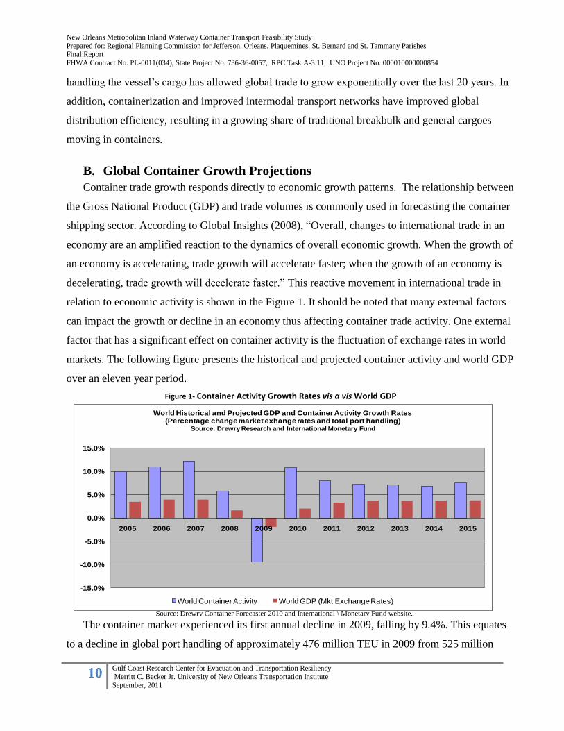
B. Global Container Growth Projections
Container trade growth responds directly to economic growth patterns. The relationship between
the Gross National Product (GDP) and trade volumes is commonly used in forecasting the container
shipping sector. According to Global Insights (2008), “Overall, changes to international trade in an
economy are an amplified reaction to the dynamics of overall economic growth. When the growth of
an economy is accelerating, trade growth will accelerate faster; when the growth of an economy is
decelerating, trade growth will decelerate faster.” This reactive movement in international trade in
relation to economic activity is shown in the Figure 1. It should be noted that many external factors
can impact the growth or decline in an economy thus affecting container trade activity. One external
factor that has a significant effect on container activity is the fluctuation of exchange rates in world
markets. The following figure presents the historical and projected container activity and world GDP
over an eleven year period.
The container market experienced its first annual decline in 2009, falling by 9.4%. This equates
to a decline in global port handling of approximately 476 million TEU in 2009 from 525 million
-15.0%
-10.0%
-5.0%
0.0%
5.0%
10.0%
15.0%
2005 2006 2007 2008 2009 2010 2011 2012 2013 2014 2015
World Historical and Projected GDP and Container Activity Growth Rates (Percentage change market exhange rates and total port handling)
Source: Drewry Research and International Monetary Fund
World Container Activity World GDP (Mkt Exchange Rates)
Source: Drewry Container Forecaster 2010 and International \ Monetary Fund website.
Figure 1- Container Activity Growth Rates vis a vis World GDP
New Orleans Metropolitan Inland Waterway Container Transport Feasibility Study
Prepared for: Regional Planning Commission for Jefferson, Orleans, Plaquemines, St. Bernard and St. Tammany Parishes Final Report
FHWA Contract No. PL-0011(034), State Project No. 736-36-0057, RPC Task A-3.11, UNO Project No. 000010000000854
11 Gulf Coast Research Center for Evacuation and Transportation Resiliency
Merritt C. Becker Jr. University of New Orleans Transportation Institute
September, 2011
TEU in 2008. Historically, from 2005 through 2007, container activity grew faster than world GDP
growth rates. This trend is projected to continue, but at a decreasing ratio of container activity to
world GDP, with container trade growing above 5% and world GDP above 3%. The consensus for
future container growth is that the double digit growth rates experienced since 2000 will not be
achieved in the near future.
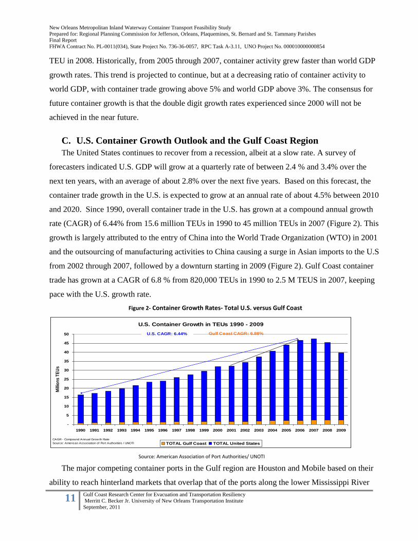
C. U.S. Container Growth Outlook and the Gulf Coast Region
The United States continues to recover from a recession, albeit at a slow rate. A survey of
forecasters indicated U.S. GDP will grow at a quarterly rate of between 2.4 % and 3.4% over the
next ten years, with an average of about 2.8% over the next five years. Based on this forecast, the
container trade growth in the U.S. is expected to grow at an annual rate of about 4.5% between 2010
and 2020. Since 1990, overall container trade in the U.S. has grown at a compound annual growth
rate (CAGR) of 6.44% from 15.6 million TEUs in 1990 to 45 million TEUs in 2007 (Figure 2). This
growth is largely attributed to the entry of China into the World Trade Organization (WTO) in 2001
and the outsourcing of manufacturing activities to China causing a surge in Asian imports to the U.S
from 2002 through 2007, followed by a downturn starting in 2009 (Figure 2). Gulf Coast container
trade has grown at a CAGR of 6.8 % from 820,000 TEUs in 1990 to 2.5 M TEUS in 2007, keeping
pace with the U.S. growth rate.
The major competing container ports in the Gulf region are Houston and Mobile based on their
ability to reach hinterland markets that overlap that of the ports along the lower Mississippi River
U.S. Container Growth in TEUs 1990 - 2009
-
5
10
15
20
25
30
35
40
45
50
1990 1991 1992 1993 1994 1995 1996 1997 1998 1999 2000 2001 2002 2003 2004 2005 2006 2007 2008 2009
Mill
ion
s T
EU
s
TOTAL Gulf Coast TOTAL United States
U.S. CAGR: 6.44% Gulf Coast CAGR: 6.88%
CAGR - Compound Annual Grow th Rate
Source: American Association of Port Authorities / UNOTI
Source: American Association of Port Authorities/ UNOTI
Figure 2- Container Growth Rates- Total U.S. versus Gulf Coast

New Orleans Metropolitan Inland Waterway Container Transport Feasibility Study
Prepared for: Regional Planning Commission for Jefferson, Orleans, Plaquemines, St. Bernard and St. Tammany Parishes Final Report
FHWA Contract No. PL-0011(034), State Project No. 736-36-0057, RPC Task A-3.11, UNO Project No. 000010000000854
12 Gulf Coast Research Center for Evacuation and Transportation Resiliency
Merritt C. Becker Jr. University of New Orleans Transportation Institute
September, 2011
region. The Port of Houston dominates the container ports in the Gulf, handling 71% of the total
Gulf container volumes in 2009, followed by the Port of New Orleans (PONO) at 9% and Mobile at
4%.
Having the only major container handling facility along the lower Mississippi river, PONO has
not experienced comparable container growth rates relative to its neighboring Gulf Coast ports,
particularly in Northeast Asian traffic. The findings from a Strategic Advisory Report1
commissioned by the PONO in 2009 indicates an average growth rate in container volumes of 1%,
with base throughput (resulting from natural growth of existing business and excluding prospective
new liner services) projected to reach 350,000 TEU in 2028. The report found that the PONO
competitive advantage is the availability of inland transportation services for containerized cargo via
truck, rail, and the direct access to the Mississippi River barge system. Although not currently
utilized as a mode for containerized cargoes, the river system is widely used for the movement of
low-value and or hazardous goods. PONO is also disadvantaged by the lack of a large local
consumer base and poor proximity to major distribution centers and networks. These two factors
tend to attract containerized commodity types.
Section 2. Inland Waterway Container Transportation (IWCT)
History shows that many great civilizations and their trading centers were formed near a sea or
river system, given the fact that waterborne transport was the primary means of moving goods and
people in ancient times. Today, the maritime shipping sector remains a key transport mode. It is
generally accepted that 90% of world trade is carried by sea, and as discussed earlier, demand for
seaborne trade is closely linked to global economies (International Maritime Organization 2005).
“Without shipping, it simply would not be possible to conduct intercontinental trade. The bulk
transport of raw materials or the import export of affordable food and manufactured goods would not
be possible– half the world would starve and the other half would freeze!” (International Maritime
Organization, 2005).
A vital component of the international transport of containerized cargo is the movement to and
from international maritime gateway ports to and from inland origin and destination points. The
1 Strategic Advisory Report: Napoleon Avenue Container Terminal Development Utilizing Public-Private Partnerships, Parsons Brinkerhoff, June
2009
New Orleans Metropolitan Inland Waterway Container Transport Feasibility Study
Prepared for: Regional Planning Commission for Jefferson, Orleans, Plaquemines, St. Bernard and St. Tammany Parishes Final Report
FHWA Contract No. PL-0011(034), State Project No. 736-36-0057, RPC Task A-3.11, UNO Project No. 000010000000854
13 Gulf Coast Research Center for Evacuation and Transportation Resiliency
Merritt C. Becker Jr. University of New Orleans Transportation Institute
September, 2011
various modes of inland transport such as road, rail, or waterway occasionally complement or
compete with one another in terms of cost, speed, accessibility, frequency and reliability. As
container volumes increase at gateway ports the traditional modes of inland transport via truck and
rail begin to reach levels that strain the capacity of their supporting infrastructure. This situation is
more prevalent on the roadway systems where passenger and freight traffic must co-exist. When a
freight transport mode becomes disadvantaged with increased transit times and/or costs over another
mode on the same route, a modal shift is more likely to occur. A modal shift also depends on the
availability of alternative transport routes that can access the same markets as the competing mode.
Inland waterway systems that access key markets can provide a high capacity alternative for longer
distance freight transport. Given certain external pressures, a modal shift to Inland Waterway
Container Transport could occur.
A. A Literature Review
To date, academic research addressing IWCT issues, particularly as they apply to the United
States, is limited. Most available literature consists of previous feasibility studies for specific ports
and regions, or only includes IWCT as a minor sub-section within larger discussions of short sea and
or intermodal shipping. All sources reviewed identify IWCT as a potentially invaluable freight
transportation opportunity, but one which is inherently challenging to implement for several reasons.
In the US, IWCT remains very limited, despite years of attempted “proof of concept” initiatives and
intermittent federal support. This review addresses the potential opportunities and advantages of
IWCT as identified in the literature, describes the challenges and limiting factors which have
inhibited its development to date, and examines the differences between the negligible IWCT
development in the US and that of Europe, where IWCT is a small but rapidly growing and
successful sector of certain freight networks.
The National Cooperative Freight Research Program recently produced a comprehensive report
on the state of MARAD’s North American Marine Highways (NAMH) initiative which identifies the
issues and research questions currently facing short sea and inland freight shipping, including, but
not limited to, container-on-barge. This report provides the most comprehensive review to date of
the state of marine freight corridors in the US, and summarizes the findings of other recent literature.
Overall, the authors conclude that NAMH has not been ‘fully embraced’ by the freight community,
New Orleans Metropolitan Inland Waterway Container Transport Feasibility Study
Prepared for: Regional Planning Commission for Jefferson, Orleans, Plaquemines, St. Bernard and St. Tammany Parishes Final Report
FHWA Contract No. PL-0011(034), State Project No. 736-36-0057, RPC Task A-3.11, UNO Project No. 000010000000854
14 Gulf Coast Research Center for Evacuation and Transportation Resiliency
Merritt C. Becker Jr. University of New Orleans Transportation Institute
September, 2011
despite MARAD’s support and enthusiasm for the initiative. They also found general consensus that
marine freight enhancements provide an environmentally and economically advantageous boost to
overall freight capacity.
Other topics addressed in the literature reviewed for this project include the findings of selected
feasibility studies conducted throughout the U.S. regarding potential IWCT development, including
real and perceived obstacles to implementation, as well as the anticipated benefits. The Port of
Pittsburgh Commission’s Container-on-Barge Pre-Feasibility Study: Final Report of 2003 includes
recommended strategies for overcoming the problems identified. Finally, three other articles
(Konings and Maras 2010; Perakis and Denisis 2008; and Weigmans 2005) also address obstacles to
and potential opportunities of IWCT. Additionally, these writings illuminate some of the differences
between the US and the successful intermodal freight policies and networks of Europe.
Inland Waterway Container Transport: Background and Current Status
Barges can typically cover about one hundred miles per day, making them slower than self-
propelled vessels, but in the case of the Mississippi River, barges are uninhibited by any locks or
dams downstream of St. Louis (Southeastern Ohio Port Authority 2008). Barge transportation
includes several subsectors such as dry bulk ( gravel, coal and agricultural products); liquid bulk in
the form of tankers; ‘general cargo’ large and semi-manufactured items; trucks, trailers, machines,
etc driven on and off of barges called “Ro/Ro”; and containers (Weigmans 2005).
Dry bulk shipping represents the majority of barge transport used in the US. Shipping containers
through inland waterways has been discussed for decades, but in the U.S., this particular mode of
maritime transportation has been relatively unsuccessful. The Osprey Line, operating out of
Houston, Texas since 2002, is the Gulf Coast and Mississippi River’s only extant IWCT operator
(although service to Memphis was discontinued in November, 2009), with service potentially
connecting Houston, New Orleans, Memphis, and other intermediate Gulf Coast and inland ports.
The company claims to have transported more than 70,000 containers between 2006 and 2008
(Southeastern Ohio Port Authority 2008). However, IWCT service has been largely discontinued
over the last two years, and the company’s website now lists only a regular weekly service from
Houston to New Orleans, with an “inducement based service” for other port pairings (RNO Group
2010). The development of a transshipment terminal port, SeaPoint, at mile twelve of the Mississippi
New Orleans Metropolitan Inland Waterway Container Transport Feasibility Study
Prepared for: Regional Planning Commission for Jefferson, Orleans, Plaquemines, St. Bernard and St. Tammany Parishes Final Report
FHWA Contract No. PL-0011(034), State Project No. 736-36-0057, RPC Task A-3.11, UNO Project No. 000010000000854
15 Gulf Coast Research Center for Evacuation and Transportation Resiliency
Merritt C. Becker Jr. University of New Orleans Transportation Institute
September, 2011
River near Venice, LA to transfer containers from ocean-going ships to river barges has been under
investigation for several years (Southeastern Ohio Port Authority 2008). More recently, the
Louisiana International Gulf Transfer Terminal (LIGTT) has been proposed as another option for
servicing mega-ships at the mouth of the Mississippi River at Southwest Pass. This terminal would
transship containers from post Panamax ships to smaller feeder vessels destined for port destinations
within the Gulf of Mexico and inland ports within the Mississippi river system. Both projects, to
date, remain unrealized.
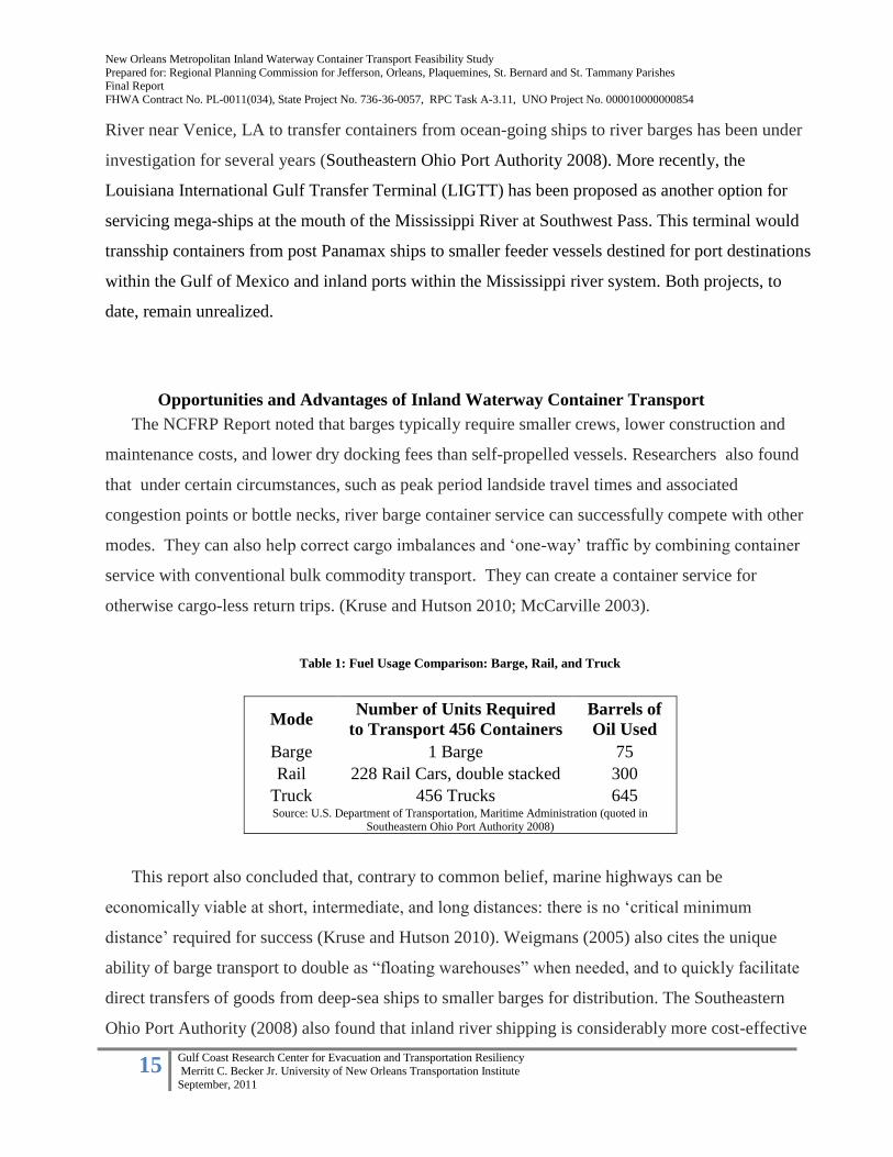
Opportunities and Advantages of Inland Waterway Container Transport
The NCFRP Report noted that barges typically require smaller crews, lower construction and
maintenance costs, and lower dry docking fees than self-propelled vessels. Researchers also found
that under certain circumstances, such as peak period landside travel times and associated
congestion points or bottle necks, river barge container service can successfully compete with other
modes. They can also help correct cargo imbalances and ‘one-way’ traffic by combining container
service with conventional bulk commodity transport. They can create a container service for
otherwise cargo-less return trips. (Kruse and Hutson 2010; McCarville 2003).
Table 1: Fuel Usage Comparison: Barge, Rail, and Truck
This report also concluded that, contrary to common belief, marine highways can be
economically viable at short, intermediate, and long distances: there is no ‘critical minimum
distance’ required for success (Kruse and Hutson 2010). Weigmans (2005) also cites the unique
ability of barge transport to double as “floating warehouses” when needed, and to quickly facilitate
direct transfers of goods from deep-sea ships to smaller barges for distribution. The Southeastern
Ohio Port Authority (2008) also found that inland river shipping is considerably more cost-effective
Mode Number of Units Required
to Transport 456 Containers
Barrels of
Oil Used
Barge 1 Barge 75
Rail 228 Rail Cars, double stacked 300
Truck 456 Trucks 645 Source: U.S. Department of Transportation, Maritime Administration (quoted in
Southeastern Ohio Port Authority 2008)

New Orleans Metropolitan Inland Waterway Container Transport Feasibility Study
Prepared for: Regional Planning Commission for Jefferson, Orleans, Plaquemines, St. Bernard and St. Tammany Parishes Final Report
FHWA Contract No. PL-0011(034), State Project No. 736-36-0057, RPC Task A-3.11, UNO Project No. 000010000000854
16 Gulf Coast Research Center for Evacuation and Transportation Resiliency
Merritt C. Becker Jr. University of New Orleans Transportation Institute
September, 2011
than either rail or truck transport, despite the longer shipping times required. In many cases, delays
in shipping yards due to congestion, known as “dwell time” which averages six to seven days at
major US ports, exceed the difference in travel time by barge (Perakis and Denisis 2008). Moreover,
for the majority of cargoes, the reliability of service, the ability to get the cargo to its destination on
time, every time, is much more important than overall shipping speed (McCarville 2003; Perakis and
Denisis 2008; Kruse and Hutson 2010). If barge service is reliable, it can effectively compete with
faster, less reliable modes.
Challenges and Limitations of IWCT
To date, the development of successful IWCT in the United States has been problematic and
limited. The simplest and most important reason is that the underdeveloped IWCT industry has not
been able to be cost-competitive with other modes for overall door-to-door service (Kruse and
Hutson 2010; Konings and Maras 2010; McCarville 2003; Perkasis and Denisis 2008; Southeastern
Ohio Port Authority 2008). Analyses of IWCT services concludes that its fundamental limiting
condition is a “chicken and egg” problem: barge service will not be developed until there is a
guaranteed demand for it, while shippers are not willing to commit to barge service until it is fully
developed and proven to be effective (Konings and Maras 2010; McCarville 2003; Southeastern
Ohio Port Authority 2008). This dilemma is a result of a complex combination of policy, technical,
infrastructural, organizational and/ or management issues.
Part of the problem is political, stemming from port fees and the Harbor Maintenance Tax
(HMT) on cargo value which are assessed to shippers who use maritime transport. These added costs
for IWCT in the U.S. enable truckers to consistently undercut marine shipping’s operating costs
(Kruse and Hutson 2010; Perakis and Denisis 2008). Further, the trucking industry has tended to
view marine highway development as competition, rather than as an opportunity to create
partnerships (as the industry has done with rail interests) to develop a regular short-haul market for
intermodal door to door services (Kruse and Hutson 2010). Modifying government policies and tax
structures to create a more favorable environment for IWCT and intermodal cooperation may be
critical to the growth and success of this transport mode (Kruse and Hutson 2010; Weigmans 2005).
Perakis and Densisis (2008) describe the overall negative attitude among shippers toward IWCT as
an “image problem” which can be corrected through better policy, research, and marketing.
New Orleans Metropolitan Inland Waterway Container Transport Feasibility Study
Prepared for: Regional Planning Commission for Jefferson, Orleans, Plaquemines, St. Bernard and St. Tammany Parishes Final Report
FHWA Contract No. PL-0011(034), State Project No. 736-36-0057, RPC Task A-3.11, UNO Project No. 000010000000854
17 Gulf Coast Research Center for Evacuation and Transportation Resiliency
Merritt C. Becker Jr. University of New Orleans Transportation Institute
September, 2011
According to the NCFRP Report (Kruse and Hutson 2010), key technical obstacles to success
have included: (1) a failure to use vessels matched to market needs and (2) an overreliance on too
few vessels per operation. Start-up IWCT shippers have been unable to access the types of vessels
and barges needed to develop cost-effective service such as several smaller vessels for low-volume,
high-frequency service, due to their high cost and low availability. This problem is partially
attributable to the Jones Act, which requires all domestic vessels to be built in the United States and
crewed by US mariners (Kruse and Hutson 2010; McCarville 2003). As a result, the service and
reliability of start-ups who are dependent on one or a few vessels are seriously impacted when
problems arise. Weigmans (2005) also cites the high start-up costs and related lack of service
flexibility and accessibility as weaknesses of inland barge transport. Finally, although the NCFRP
report found that port infrastructure issues were not a serious deterrent to IWCT, some river
terminals may need expensive equipment upgrades to efficiently handle container service
(McCarville 2003).
The failures of previous domestic attempts at IWCT, moreover, can be attributed to not only the
industry-wide obstacles described above, but also specific organizational and management-related
limiting factors and weaknesses. Lack of experience on the part of both shippers and operators,
over-dependence on single shippers, and in the case of the Lower Mississippi River corridor a highly
competitive and well-developed parallel rail network are all examples of this problem (McCarville
2003). In addition, better organization and leadership is required in order to provide accurate
information to potential shippers and operators regarding costs, schedules, transit times, intermodal
connections, and insurance in order to make informed decisions (Southeastern Ohio Port Authority
2008).
Regarding the development of IWCT along the Gulf Coast and the Mississippi River, in
particular, the RNO Group in 2010 identified the overall weakness of container volume being less
than 1.5% of all U.S. containers use the Mississippi River for inland transport, as the single largest
obstacle to IWCT development. The development of a Mississippi River “Container Gateway,” they
claim, is crucial to capitalizing on the Panama Canal expansion and the anticipated increase in Gulf
container activity.

New Orleans Metropolitan Inland Waterway Container Transport Feasibility Study
Prepared for: Regional Planning Commission for Jefferson, Orleans, Plaquemines, St. Bernard and St. Tammany Parishes Final Report
FHWA Contract No. PL-0011(034), State Project No. 736-36-0057, RPC Task A-3.11, UNO Project No. 000010000000854
18 Gulf Coast Research Center for Evacuation and Transportation Resiliency
Merritt C. Becker Jr. University of New Orleans Transportation Institute
September, 2011
IWCT: Lessons from Europe
Compared to the United States, Europe, and in particular the inland waterway network
originating in the Netherlands and operating along the Rhine River, has a much more fully
developed and robust inland waterway shipping sector. Over several decades, the E.U. has
developed marine-supportive policies which have promoted investment and improved
competitiveness for IWCT (Kruse and Hutson 2010; Weigmans 2005; McCarville 2003; Konings
and Maras 2010). Several of these policy decisions, as well as organizational advances within the
industry, can provide a valuable model for enhancing and supporting domestic IWCT development
in the U.S..
Barge transport increased across Europe by 10% between 1994 and 2003 (Weigmans 2005). Of
this increase, container barge traffic has been the fastest-growing sector, although container barges
still only made up about 4% of barge activity by ton in 2002. The vast majority of barge activity, as
in the US, consists of dry and liquid bulk transport (Weigmans 2005). Current European IWCT
volume is estimated at 5 million TEU annually (Konings and Maras 2010). In the Netherlands, barge
transportation is the second most important freight mode after trucks (Weigmans 2005), though
elsewhere it still makes up a relatively small component of the overall freight network.
The capacity of European inland waterways has not been reached, while other modes, like rail
and roads, have become increasingly congested, and developing marine transport is therefore more
critical as an alternative transport mode than in the U.S. (Weigmans 2005). As a result, several
policies supporting IWCT have been implemented by the European Union. For example, the
Motorways of the Sea (MoS) initiative, which provides grants for new corridors, and the Marco Polo
program, which funds projects that reduce road freight volumes and facilitates regional and
international cooperation (Kruse and Hutson 2010). The E.U. also imposed trucking surcharges to
bolster the effectiveness of marine policy by ‘leveling the playing field’ among modes (Kruse and
Hutson 2010). Meanwhile, individual national governments have been tasked with tailoring and
implementing European Union policy guidelines to fit the individual nation’s unique conditions and
constraints, with varying degrees of success (Weigmans 2005).
The design of Europe’s inland marine transport network supports freight efficiency and
intermodal connectivity.. Early IWCT start-ups demonstrated their dedication to providing reliable,
timely service by sailing when under capacity and at a loss (McCarville 2003). They also developed
strong relationships with ocean carriers and ground transportation providers from the outset to

New Orleans Metropolitan Inland Waterway Container Transport Feasibility Study
Prepared for: Regional Planning Commission for Jefferson, Orleans, Plaquemines, St. Bernard and St. Tammany Parishes Final Report
FHWA Contract No. PL-0011(034), State Project No. 736-36-0057, RPC Task A-3.11, UNO Project No. 000010000000854
19 Gulf Coast Research Center for Evacuation and Transportation Resiliency
Merritt C. Becker Jr. University of New Orleans Transportation Institute
September, 2011
complete the supply chain and provide a desirable service for shippers (McCarville 2003). More
recently, a series of technical barge innovations, including new fuel and engine technologies, loading
and unloading equipment, and related advances, have helped support IWCT growth and could
further enhance its market share (Weigmans 2005; Perakis and Denisis 2008).
Perhaps the most significant innovation in European IWCT, which the US may wish to emulate,
is the ongoing development of ‘hub-and-spoke’ barge transport networks, in which large intermodal
ports serve as hubs for smaller ‘spoke’ terminals (Konings and Maras 2010; Kruse and Hutson 2010;
Weigmans 2005). Konings and Maras (2010) argue that hub-and-spoke service development is the
key to opening up new markets for IWCT, as it allows greater frequency with smaller volumes and
vessels, when freight volumes are not large enough to cost-effectively justify point-to-point (direct)
service. They also note that such a system is highly responsive to market fluctuations and can
expand and contract as needed.
Hub-and-spoke services do increase the overall transit time over direct service, and can
potentially be vulnerable to disruption due to the system’s interconnectedness, however, Konings
and Maras find that overall, such systems improve the performance of IWCT services and tend to be
more cost-effective for shippers. But since inland waterway transport is best employed for less time-
sensitive cargo, they add, the additional travel time should be of negligible impact. If carefully
planned and implemented, Hub-and-Spoke networking in the U.S. could prove to be one important
tool to making IWCT more cost-competitive with trucking (Konings and Maras 2010).
The approximate distance along the Rhine and Mississippi rivers are as follows:
Mississippi River
Southwest Pass – Memphis (740 miles)
Southwest Pass – St. Louis (1210 miles)
Rhine River
Rotterdam/Antwerp – Duisburg (140 miles)
Rotterdam/Antwerp – Manheim (500 miles)
New Orleans Metropolitan Inland Waterway Container Transport Feasibility Study
Prepared for: Regional Planning Commission for Jefferson, Orleans, Plaquemines, St. Bernard and St. Tammany Parishes Final Report
FHWA Contract No. PL-0011(034), State Project No. 736-36-0057, RPC Task A-3.11, UNO Project No. 000010000000854
20 Gulf Coast Research Center for Evacuation and Transportation Resiliency
Merritt C. Becker Jr. University of New Orleans Transportation Institute
September, 2011
Policy Implications and Technical Needs of U.S. IWCT Development
Several of the findings regarding IWCT development, in the US and abroad, are clear and
consistent. Supportive government policies must be in place which put marine transport on even
footing with trucking and/or rail transport. The vessel fleets must match market needs to achieve
efficiency and provide adequate frequency. IWCT services must be reliable and cost competitive
(Kruse and Hutson 2010; McCarville 2003; Weigmans 2005; Perakis and Denisis 2008).
Kruse and Hutson (2010) define the most important policy concern as the need to modify or
compensate for the HMT, Title XI, and the Jones Act, possibly by providing tax credits for marine
transport operators, providing direct incentives for shippers (which, they claim, is more effective
than incentivizing operators) or allowing the use of Congestion Mitigation Air Quality (CMAQ)
funds for marine projects which reduce surface transportation congestion. CMAQ funds have long
been used for projects which substitute train travel for truck travel, and studies indicate that the
public benefits of truck-barge substitutions are at least as great (McCarville 2003). The ports of
Houston and New York have already successfully accessed these funds through SAFETEA for
specific projects (McCarville 2003).
Kruse and Hutson also stress the need to eliminate current subsidies for the trucking industry and
to make marine highway programs more ‘trucker-friendly.’ They go on to suggest the use of the
EU’s Marco Polo program as a model for encouraging multimodalism on a national scale.
McCarville adds that existing programs which could be beneficial, include MARAD’s Ship
Operations Cooperative or Cargo Handling Cooperative Program, if they were better used, and better
funded, to serve inland waterway freight development.
Such incentives and policy actions, particularly if concentrated on a few key corridors with the
greatest industry potential, would help to reduce the ‘chicken-and-egg’ dilemma which has thwarted
efforts to implement IWCT to date. These policies, would also help improve the public perception
of this transport mode, which has been damaged by public investment in failed operations (Kruse
and Hutson 2010; McCarville 2003; Weigmans 2005). Examples of domestic successes do exist. On
the Columbia/Snake River waterway, a small but successful modified hub-and-spoke IWCT network
is operational. This network was developed to provide container transfers from Asian ocean vessels
to barges in Portland, then distributing boxes to various inland ports for export cargoes, primarily
agricultural commodities (Kruse and Hutson 2010). The Columbia/Snake River IWCT network
handled 50,000 containers in 2000, up from a starting point of 125 containers in 1975 (McCarville
New Orleans Metropolitan Inland Waterway Container Transport Feasibility Study
Prepared for: Regional Planning Commission for Jefferson, Orleans, Plaquemines, St. Bernard and St. Tammany Parishes Final Report
FHWA Contract No. PL-0011(034), State Project No. 736-36-0057, RPC Task A-3.11, UNO Project No. 000010000000854
21 Gulf Coast Research Center for Evacuation and Transportation Resiliency
Merritt C. Becker Jr. University of New Orleans Transportation Institute
September, 2011
2003). Current volumes are significantly less than the peak in 2000 primarily due to ocean carriers
cancelling the Port of Portland as a call on their voyage rotation.
In addition to supportive federal policy, solutions to technical problems associated with IWCT
must be addressed. Intermodal connections which allow seamless door-to-door service must be
improved (Perakis and Denisis 2008). Hub-and-Spoke networks should be explored and refined to
improve efficiency (Kerakis and Denisis 2008;). New, innovative vessels and barges, such as smaller
vessels and articulated tugs and barges, rather than integrated tows, which match market needs and
allow more efficient loading and unloading must be constructed, preferably in large quantities, so
as to reduce their cost in light of the impact of the Jones Act (Kruse and Hutson 2010; RNO Group
2010).
Given the sparse literature available on IWCT development, particularly in the U.S., more
research, and stronger industry and political leadership, are needed in order to holistically understand
how to successfully implement new services and networks (Kruse and Hutson 2010). Several failed
attempts at generating IWCT activity in the U.S. have left shippers and operators uninterested in its
potential economic and environmental advantages. Research quantifying those benefits, and policies
which respond to the need to improve air quality and reduce fuel consumption by incentivizing
marine freight development, are needed if successful domestic inland waterway container transport
is to serve a greater role in U.S. freight movement.
B. European Inland Waterway Container Service
Europe has over 30,000 km of canals and rivers forming a network that links key industrial areas
and population centers. The main international waterway systems in Western and South-Eastern
Europe consist of the Rhine and Danube rivers, with tributaries and canals connecting to the smaller
towns and industrial centers in this part of Europe. The core network connects the Netherlands,
Belgium, Luxembourg, France, Germany, and Austria through numerous inland ports and landing
stages providing access to other modes of transport. The inland ports provide for regional
transshipment that is tri-modal in nature, providing access to road, rail and water. International
traffic is dominant at the larger inland ports due to structural agreements and collaboration with the
gateway seaports. Some of the inland ports have increasingly grown to a point where they are
serving as back up and feeder points for the major seaports, and acting as decongestion hubs. This is

New Orleans Metropolitan Inland Waterway Container Transport Feasibility Study
Prepared for: Regional Planning Commission for Jefferson, Orleans, Plaquemines, St. Bernard and St. Tammany Parishes Final Report
FHWA Contract No. PL-0011(034), State Project No. 736-36-0057, RPC Task A-3.11, UNO Project No. 000010000000854
22 Gulf Coast Research Center for Evacuation and Transportation Resiliency
Merritt C. Becker Jr. University of New Orleans Transportation Institute
September, 2011
more predominant at inland ports capable of serving short sea shipping vessels such as Duisburg.
The Rhine River corridor is by far the most dominant market for inland river container transport in
Europe, with over 2 million TEUs being transported in 2008. For the purpose of this section, the
Rhine river delta will be profiled as the European waterway system most like the Mississippi River
system.
The Rhine Delta
The largest inland ports with the most container traffic can be found on the Rhine Delta. This
area of the continent serves as Europe’s largest industrial base. The Rhine Delta system has been
largely influenced by the development and growth of the container gateway seaports of Antwerp and
Rotterdam. (See Figure 3) Today, these two gateway ports at the mouth of the Rhine River provide
the needed critical mass that allow for sustainable inland waterway transport in Western Europe.
They account for approximately 95% of IWCT traffic moving within the Rhine Delta river system.
Another influential factor, in addition to the combined container throughput at the ports, is the access
to the industrial and consumption markets located along the Rhine river system. In general, the
geography of Western Europe is ideally suited for IWCT due to its population densities located in
* data not available EVP = Equivalent Vingt Pieds (French: Twenty Foot Equivalent Unit -TEU) Source: Central Commission for the Navigation of the Rhine (CCNR)
Figure 3 Inland river container transport flows in Europe

New Orleans Metropolitan Inland Waterway Container Transport Feasibility Study
Prepared for: Regional Planning Commission for Jefferson, Orleans, Plaquemines, St. Bernard and St. Tammany Parishes Final Report
FHWA Contract No. PL-0011(034), State Project No. 736-36-0057, RPC Task A-3.11, UNO Project No. 000010000000854
23 Gulf Coast Research Center for Evacuation and Transportation Resiliency
Merritt C. Becker Jr. University of New Orleans Transportation Institute
September, 2011
Gateway Ports Inland PortsGateway Ports Inland Ports
Source: National Ports and Waterways Institute / UNOTI
close proximity to its navigable waterways. As mentioned earlier, the location of the gateway ports
along the North Sea and the access to a large industrial base contribute to the sustainability of IWCT
on the Rhine River system.
The Rhine Delta Market can be broken
down into three major trades:
Rhine River Trade. Barge Container
movements between the ports of
Antwerp / Rotterdam and the
industrial and consumption areas in
Germany, France and Switzerland.
Rotterdam – Antwerp
International Trade. Waterborne
Barge Container movements between
the Ports of Rotterdam and Antwerp.
This traffic is the result of ocean
carriers’ primary port strategy of
calling on one port and feedering
containers to the other inland ports by barge.
Domestic trade. Local barge container movements between Rotterdam / Antwerp and inland
destinations in the Netherlands.
The inland port terminals along the Rhine are key components to the sustainability of IWCT
within the Rhine River system. These inland ports are divided into three navigational stretches:
Lower, Middle, and Upper (See Figure 4). The average turnaround times for vessels within each
section to the gateway ports are: Lower – two round-trips per week: Middle – one round-trip per
week: Upper – one roundtrip per two weeks.
The largest inland container handling ports are located within the Lower Rhine section. They
are Duisburg and Neuss-Dusseldorf. The Port of Duisburg is located at the confluence of the Rhine
Figure 4 : Rhine Delta Trade Sections

New Orleans Metropolitan Inland Waterway Container Transport Feasibility Study
Prepared for: Regional Planning Commission for Jefferson, Orleans, Plaquemines, St. Bernard and St. Tammany Parishes Final Report
FHWA Contract No. PL-0011(034), State Project No. 736-36-0057, RPC Task A-3.11, UNO Project No. 000010000000854
24 Gulf Coast Research Center for Evacuation and Transportation Resiliency
Merritt C. Becker Jr. University of New Orleans Transportation Institute
September, 2011
and Ruhr rivers in the industrial heartland of the Nordrhein Westphalen. According to the Journal of
Commerce, Duisburg is considered the world’s busiest inland port. It handled 2.25 million TEU
delivered through inland waterway vessel, trucks and freight rail in 2010. The port has developed as
an international logistics hub for freight of all kinds, which can be distributed by rail, road and water.
Roughly 30 million people live and work within a 150 kilometer radius of Duisburg. The waterway
and rail shuttle services primarily serve Antwerp, Zeebrugge, and Rotterdam.
Following Duisburg in terms of throughput along the lower Rhine section is the Port of Neuss-
Dusseldorf, with a total container throughput in 2009 of 566,000 TEU. The Port of Rotterdam and
the Port of Neuss-Dusseldorf are connected with 13 inland barge services per week, as well as 4
services per week by rail and it is expected to increase throughput in the next 15 years to 1.6 million
TEU, according the Port of Rotterdam.
Located within the middle Rhine section is the Port of Mannheim, which primarily services the
Rhine-Neckar industrial and technology center, an economic region with a population of 24 million
people. The port complex is host to the largest BASF chemical plant worldwide which employs over
37,000. In 2009, according to the European Federation of Inland Ports, the port handled 95,132
TEU.
The Upper section of the Rhine handles the least amount of containers through the inland ports
of Strasbourg in France which handled 74,845 TEU in 2008 and Basel in Switzerland which handled
92,464 TEU in 2008.
Historical Growth in European IWCT (1975 – Present)
Inland waterway transport of containers has developed over the last twenty years in northwest
Europe as a successful mode of inland transportation. Over the past decade European IWCT has
grown annually by 10% to 15% (Konings 2006). The development and historical growth pattern of
European IWCT network has been described in four phases over the last 25 years. According to
Theo Notteboom (2007) at the Institute of Transport and Maritime Management Antwerp, the four
phases of container barge transport can be characterized as follows:

New Orleans Metropolitan Inland Waterway Container Transport Feasibility Study
Prepared for: Regional Planning Commission for Jefferson, Orleans, Plaquemines, St. Bernard and St. Tammany Parishes Final Report
FHWA Contract No. PL-0011(034), State Project No. 736-36-0057, RPC Task A-3.11, UNO Project No. 000010000000854
25 Gulf Coast Research Center for Evacuation and Transportation Resiliency
Merritt C. Becker Jr. University of New Orleans Transportation Institute
September, 2011
First Phase (Mid -1968 until Early 1970s): IWCT volume on the Rhine did not exceed 10,000
TEU until 1975
Small containerized volumes were carried at irregular intervals by conventional barges from
Rotterdam to transshipment points on the upper and middle Rhine. The first inland terminal was
designed in Mannheim (middle Rhine) followed by terminals at Strasbourg and Basel (upper
Rhine)
Services grouped empty containers in the immediate area of the users, and original service did
not include transshipment, and pre-hauls and end-hauls by truck.
Second Phase (mid 1970s till mid 1980s): IWTC Volume Growth from mid 70s to mid 80s
(10,000 – 210,000 TEU)
Growth in maritime container transport led to a limited number of port calls resulting in a high
concentration of container volumes at a limited number of seaports.
A critical mass of containers at the ports allowed for more scheduled container services by barge
to gradually develop.
Competitiveness was gained through a guarantee of fixed departure schedules for each
navigation area (except during periods of low water levels)
New terminal development occurred along the middle and upper Rhine areas to keep pace with
rising volumes. (i.e. no less than 20 new Rhine terminals were opened in the period between
1970 - 1980)
Third Phase (mid 1980s till mid 1990s): IWTC Volume Growth from mid 80s to mid 90s
(210,000 – 743,000 TEU)
Terminal development occurred along the Lower Rhine as a result of large scale growth at the
seaports. In Antwerp, containerized barge traffic increased from 128,700 TEU in 1985 to
675,000 TEU in1995, and in Rotterdam from 225,000 TEU in 1985 to 1.15 million TEU in 1995.
Existing barge carriers began operating joint liner services on the different navigation areas,
supported by operation collaboration agreements between them. Sailing schedules were
streamlined to offer high frequency service from the seaports to the Lower Rhine.

New Orleans Metropolitan Inland Waterway Container Transport Feasibility Study
Prepared for: Regional Planning Commission for Jefferson, Orleans, Plaquemines, St. Bernard and St. Tammany Parishes Final Report
FHWA Contract No. PL-0011(034), State Project No. 736-36-0057, RPC Task A-3.11, UNO Project No. 000010000000854
26 Gulf Coast Research Center for Evacuation and Transportation Resiliency
Merritt C. Becker Jr. University of New Orleans Transportation Institute
September, 2011
Fourth Phase (Since mid-1990s): IWTC Volume Growth from mid 90s to present 743,000 –
1,969,000 TEU
Transport by barge begins to grow beyond the Rhine basin.
In reaction to the potential opportunities of containerized barge transport, new terminal
investment occurred in northern France, the Netherlands, and Belgium.
Shuttle services between the Ports of Antwerp and Rotterdam emerged.
Growth is partly initiated by financial incentives given by local, regional and national authorities.
It is clear that the growth pattern over these four phases demonstrates that as volumes of
containers at the gateway ports increases so does the volumes along the Rhine Delta. (Figure 5) The
development of the inland river container services in Europe can also be attributed to service
operators’ response to the market demand by providing bundled and scheduled services, as well as
terminal investments at inland ports. The modal split of containers at the Ports of Rotterdam and
Antwerp has shown a slight shift from trucks to barge over the last five years.
Container throughputs for the Ports of Rotterdam, Antwerp and the Rhine Delta
0
2,000
4,000
6,000
8,000
10,000
12,000
1990 1991 1992 1993 1994 1995 1996 1997 1998 1999 2000 2001 2002 2003 2004 2005 2006 2007 2008 2009
(in TEUs x 000)
Rotterdam Antwerp Rhine Delta
Source: Antwerp Port Authority, Port of Rotterdam Authority, Central Commission for Navigation on the Rhine
Figure 5 TEU throughputs via Rotterdam, Antwerp and the Rhine Delta
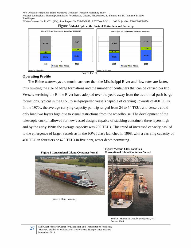
New Orleans Metropolitan Inland Waterway Container Transport Feasibility Study
Prepared for: Regional Planning Commission for Jefferson, Orleans, Plaquemines, St. Bernard and St. Tammany Parishes Final Report
FHWA Contract No. PL-0011(034), State Project No. 736-36-0057, RPC Task A-3.11, UNO Project No. 000010000000854
27 Gulf Coast Research Center for Evacuation and Transportation Resiliency
Merritt C. Becker Jr. University of New Orleans Transportation Institute
September, 2011
Operating Profile
The Rhine waterways are much narrower than the Mississippi River and flow rates are faster,
thus limiting the size of barge formations and the number of containers that can be carried per trip.
Vessels servicing the Rhine River have adopted over the years away from the traditional push barge
formations, typical in the U.S., to self-propelled vessels capable of carrying upwards of 400 TEUs.
In the 1970s, the average carrying capacity per trip ranged from 24 to 54 TEUs and vessels could
only load two layers high due to visual restrictions from the wheelhouse. The development of the
telescopic cockpit allowed for new vessel designs capable of stacking containers three layers high
and by the early 1990s the average capacity was 200 TEUs. This trend of increased capacity has led
to the emergence of larger vessels as in the JOWI class launched in 1998, with a carrying capacity of
400 TEU in four tiers or 470 TEUs in five tiers, water depth permitting.
Modal Split via The Port of Antwerp 2005/2010
34.2%45.0%
8.1%
12.0%
57.7%43.0%
2005 2010
Source: Port of Antwerp
Barge Rail Road
Modal Split via The Port of Rotterdam 2005/2010
30.5%39.0%
9.4%
13.5%
60.1%47.5%
2005 2010
Source: Port of Rotterdam
Barge Rail Road
Source: Port of Rotterdam
Figure 6 Modal Split at the Ports of Rotterdam and Antwerp
Figure 8 Conventional Inland Container Vessel
Source : RhineContainer
Source : Manual of Danube Navigation, via
Donau, 2005
Figure 7“Jowi” Class Next to a
Conventional Inland Container Vessel
New Orleans Metropolitan Inland Waterway Container Transport Feasibility Study
Prepared for: Regional Planning Commission for Jefferson, Orleans, Plaquemines, St. Bernard and St. Tammany Parishes Final Report
FHWA Contract No. PL-0011(034), State Project No. 736-36-0057, RPC Task A-3.11, UNO Project No. 000010000000854
28 Gulf Coast Research Center for Evacuation and Transportation Resiliency
Merritt C. Becker Jr. University of New Orleans Transportation Institute
September, 2011
Current Policy Initiatives
Realizing the need to balance freight transport between water, rail and road systems, to improve
air quality and reduce roadway congestion, the EU has established a number of policies and
programs that incentivize certain decisions in the transport sector. These have included the
following:
Marco Polo Program
The European Union’s Marco Polo program was launched in 2003, with the goal of reducing
roadway congestion and vehicular emissions by encouraging and supporting projects which promote
the efficient and profitable use of rail, marine, and inland waterway freight transport. The program
was reauthorized and expanded as Marco Polo II in 2007. This second phase is currently funded
through 2013. Marco Polo is jointly run by the European Commission’s Directorate-General for
Mobility and Transport, and the European Union’s Executive Agency for Competitiveness and
Innovation. The program provides grants for five categories of projects (European Commission
2011):
Direct modal shifts from roads to rail or water (includes intermodal projects which is the
main focus of the program)
Catalytic actions which promote modal shift (i.e. technology development)
“Motorways of the Sea” between major ports (intermodal projects which divert large
volumes of freight from roads to waterborne vessels; Added in 2007)
Traffic avoidance (trip reduction through supply chain logistics; Added in 2007)
Common learning actions (projects which promote education and awareness in
intermodal transport)
Between 2003 and 2009, 125 projects involving more than 500 companies and publicly owned
commercial entities have successfully utilized Marco Polo funds. The Program’s 2010 budget is €64
million or US $93 million, and the application process is competitive (European Commission 2011).
Criteria for award selection include: the quantity of freight shifted from roadways, anticipated
environmental benefits, and the credibility and viability of the project and its operators (RNO Group
2007).
Grants cover a share of a project’s capital and operating costs, and last from two to five years, at
which point projects are expected to be financially self-sufficient. The maximum grant awarded to

New Orleans Metropolitan Inland Waterway Container Transport Feasibility Study
Prepared for: Regional Planning Commission for Jefferson, Orleans, Plaquemines, St. Bernard and St. Tammany Parishes Final Report
FHWA Contract No. PL-0011(034), State Project No. 736-36-0057, RPC Task A-3.11, UNO Project No. 000010000000854
29 Gulf Coast Research Center for Evacuation and Transportation Resiliency
Merritt C. Becker Jr. University of New Orleans Transportation Institute
September, 2011
date for a single project has been €7.5 million or US $11.9 million. Projects are required to cross an
international border, and passenger transport projects, air transport projects, and pure research
projects are ineligible (European Commission 2011).
Most of the projects (79%) which have been implemented as a result of this program are focused
on creating direct modal shifts to rail and water—the principle focus of the program. Modal shift
projects are required, at minimum, to divert an average of 60 million ton-kilometers of traffic from
roadways to rail or waterways per year over the duration of the grant in order to be eligible. Modal
shift projects which propose upgrading existing rail, water, or intermodal services are eligible, but
must clearly demonstrate the added value of the upgrade in terms of additional modal shift generated
by the project. Recipients are required to periodically report on project progress and outcomes
(European Commission 2011).
In 2009, the last year for which complete data is available, 22 projects were funded. Rail projects
dominated, with 41% of the total, while two projects were dedicated to inland waterway transport,
and five more focused on short sea shipping, including one “Motorways of the Sea” (MoS) project.
MOS-designated projects create efficient door-to-door intermodal services utilizing marine transport
between major ports and rail or water-based inland distribution. This facet of the program
complements the Trans-European Networks Motorways of the Sea network, which finances
exclusively public-sector infrastructure in support of short-sea shipping (European Commission
2011).
Grants awarded to projects between 2007 and 2009 alone are expected to reduce road freight by
54 billion ton-kilometers, with an anticipated environmental and social benefit (cost avoidance) of
€1.4 billion or US $2 billion. (European Commission 2011).
Contributing factors for the development of IWTC in Europe include the following:
Market
The choice of international gateway container ports close to the mouth of the Rhine River
Delta has created a critical mass of containers requiring transportation by multiple modes.
With greater volumes of containers at the gateway seaports, the use of inland waterway
services becomes more advantageous. (Notteboom, 2002)

New Orleans Metropolitan Inland Waterway Container Transport Feasibility Study
Prepared for: Regional Planning Commission for Jefferson, Orleans, Plaquemines, St. Bernard and St. Tammany Parishes Final Report
FHWA Contract No. PL-0011(034), State Project No. 736-36-0057, RPC Task A-3.11, UNO Project No. 000010000000854
30 Gulf Coast Research Center for Evacuation and Transportation Resiliency
Merritt C. Becker Jr. University of New Orleans Transportation Institute
September, 2011
The more distant the markets from the port the greater the opportunities to exploit
waterway transport (Fremont, Franc, and Slack 2009)
Infrastructure
Weak highway and rail infrastructure necessitated intermodal service through waterways.
The creation of numerous inland river container terminals has expanded the reach of
seaports into the European hinterland.
An existing inland waterway network permits services to the hinterland, particularly the
largest cities. The greater the network’s density and interconnectivity with other basins,
the greater the possibilities of serving a large hinterland (Konings, 2002)
Service
24-hour terminal operations create greater options for shippers.
Inland waterway services need to be reliable and frequent and offer a transit time which
is competitive to road and rail. There must be network of inland waterway terminals or
hubs, where traffic flows are concentrated and cargoes can be broken out and routed to
their final destinations (Konings 2006)
Location with respect to markets is essential.
The shipper needs an integrated end-to-end service between the maritime terminal and
the final destination (Panayides et al. 2002)
No weight limitations for IWCT cargo offer a natural inducement for specific cargoes.
Unimposed rate structures – On other modes of transport, official freight rates are
imposed by external forces. These can often be higher than the market will bear which
causes customers to shift modes.
Combined waterway-road transport must be more competitive than road transport, both
with regard to the price of door-to-door services and the quality of the service. (Vellenga
et all. 1999)
Inland Container Depot (ICD) status – Inland Container Depots (ICDs) are dry ports
equipped for handling and temporary storage of containerized cargo as well as empties.
ICD status is given to the inland terminal by the ocean carrier. This allows their
customers to pick up or return empty containers inland; as opposed to having to return
them to the seaport. This also allows for customers to obtain empty equipment to load at
New Orleans Metropolitan Inland Waterway Container Transport Feasibility Study
Prepared for: Regional Planning Commission for Jefferson, Orleans, Plaquemines, St. Bernard and St. Tammany Parishes Final Report
FHWA Contract No. PL-0011(034), State Project No. 736-36-0057, RPC Task A-3.11, UNO Project No. 000010000000854
31 Gulf Coast Research Center for Evacuation and Transportation Resiliency
Merritt C. Becker Jr. University of New Orleans Transportation Institute
September, 2011
their inland location on short notice. The ICD status of an inland terminal is market
driven based on the throughput volume that is generated.
Customs Clearance is provided at inland points.
Policy
European Union transportation policies promote inland waterway usage.
Legislation favors intermodal transport – Distance limitations are mandated on road legs
in combined transport moves (within 150 km from the terminal). The inducement: heavy
containers can be carried two on a chassis within the 150 km parameter of the combined
transport terminal. A direct truck movement would have to be a single container.
“Polluter Pays” – Use of roads for long-distance transportation cause air pollution and
users are taxed accordingly which has resulted in modal shifts to rail and water.
C. United States Inland Waterway Container Transport
Overall, inland waterway container transportation has remained limited in the United States, and
constitutes a fairly small proportion of total waterway transport activity. Unlike in Europe, where
container barge services have been successfully developing and growing in importance since the
1970s, United States inland waterway container transportation in the United States is still in its
infancy. Despite decades of interest and demonstrated, but limited, federal support, very few inland
container services have been created and an even smaller number have succeeded. Non-
containerized bulk commodity transportation still constitutes the great majority of goods transported
on U.S. waterways.
The US has nearly 12,000 miles of navigable, commercially active inland and intracoastal
waterways serving 38 states, with a replacement value estimated at over $125 billion dollars.
(USACOE 2000). Of this, nearly 11,000 miles of waterways are supported by the Inland Waterways
Trust Fund, which is supported by fuel taxes paid by commercial waterway operators, and which
funds new construction and rehabilitation of infrastructure. About 630 million tons of cargo (valued
at more than $73 billion dollars) are moved through these waterways each year. Louisiana and Texas
ship the greatest value of cargo per year through intracoastal and inland waterways, valued at more
than $10 billion dollars per state (USACOE 2000).

New Orleans Metropolitan Inland Waterway Container Transport Feasibility Study
Prepared for: Regional Planning Commission for Jefferson, Orleans, Plaquemines, St. Bernard and St. Tammany Parishes Final Report
FHWA Contract No. PL-0011(034), State Project No. 736-36-0057, RPC Task A-3.11, UNO Project No. 000010000000854
32 Gulf Coast Research Center for Evacuation and Transportation Resiliency
Merritt C. Becker Jr. University of New Orleans Transportation Institute
September, 2011
United States IWCT (1975 – Present)
Since the mid 70’s there have been repeated efforts in the U.S. by both the public and private
sectors to demonstrate the value and validity of IWCT. To date, for a variety of reasons, this form of
transport has seen limited success, although it has been tried in various forms and fashions in
different geographic locales throughout the country. The following is not intended to document the
extent of these services, but rather to illustrate specific examples of demonstration services that have
succeeded or failed and to point out their significance to the overall conceptual framework for IWCT
in the U.S. and within the Mississippi River corridor.
In March 1994, America’s Marine Express, a subsidiary of Kirby Corp., began an all-water
service between Memphis, TN and Mexico, Guatemala, Honduras, and El Salvador through the
Mississippi River. The service utilized a chartered river-ocean vessel offering Midwest shippers a
direct alternative between Memphis – Mexico – Central America on a fourteen day round trip
Mobile
Houston
New
Orleans
GulfportMobile
Houston
New
Orleans
Gulfport
Source: Adapted from Wikimedia Commons, UNOTI
Gulf Container Ports
Major Inland River Ports
Gulf Container Ports
Major Inland River Ports
Figure 9 Mississippi Valley Waterway System

New Orleans Metropolitan Inland Waterway Container Transport Feasibility Study
Prepared for: Regional Planning Commission for Jefferson, Orleans, Plaquemines, St. Bernard and St. Tammany Parishes Final Report
FHWA Contract No. PL-0011(034), State Project No. 736-36-0057, RPC Task A-3.11, UNO Project No. 000010000000854
33 Gulf Coast Research Center for Evacuation and Transportation Resiliency
Merritt C. Becker Jr. University of New Orleans Transportation Institute
September, 2011
voyage. In August 1994, the service was discontinued as aggressive pricing from rail and truck
competitors resulted in slower than anticipated acceptance of the service. Although volumes were
increasing with each voyage; operating losses and negative prospects for future profitability did not
warrant continuation of the services.
Beginning in 2000, the Osprey Line offered container barge service from Houston to New
Orleans, and from New Orleans to Memphis. The line has focused on marketing their services for
heavy and out of gauge cargos to maximize value (Kruse and Hutson 2010). The Memphis-New
Orleans service relied on containerized cotton, lumber, and glucose (all southbound for export on
containerships). Transit times were five days by barge, compared to 6 hours by truck. (Fritelli
2011). After Hurricane Katrina, Osprey lost significant New Orleans business, and the Memphis
service was ultimately discontinued in 2009 due to a lack of northbound cargo (Kruse and Hutson
2010). Osprey attempted to establish IWCT service between Memphis and Louisville, but this was
unsuccessful (Fritelli 2011). Today, the remaining Houston-New Orleans service operates on an
inducement basis only (Kruse and Hutson 2010). According to Rick Couch, the operator of Osprey
Line at the time, “Another hindrance to the success of the service was the port and dockage fees
imposed on the water carrier but no similar charge to the truck lines. Ports should either waive
dockage and port charges for IWCT or charge trucks or rail to come and go in and out of the port.
Although not a deal breaker, these charges make IWCT less competitive with other modes.”
Other current inland waterway operations include the 64 Express between Norfolk and
Richmond, VA, using the James River, which has been operating since 2008 with conventional river
barges and leveraging CMAQ funds. The service was recently awarded additional CMAQ and
Marine Highway grants to expand their service, despite recent declines in container volume due to
the loss of direct service to an important transatlantic container line (Fritelli 2011). However, the
service has a diverse potential Richmond, VA customer base, and may be able to rebuild their
market due to increasing highway congestion in the region (Fritelli 2011).
Marine Highway funds, amounting to $1.76 million, have also been allocated to the
establishment of new IWCT service on the Tenn-Tom waterway between Mobile, AL, and
Itawamba, MS (Fritelli 2011). TIGER funding has been set aside for Granite City, IL, and Cates
Landing, TN for the construction of new Mississippi River ports, while the Port of Providence has
received $10.5million to upgrade container handling infrastructure for coastal service (Fritelli 2011).

New Orleans Metropolitan Inland Waterway Container Transport Feasibility Study
Prepared for: Regional Planning Commission for Jefferson, Orleans, Plaquemines, St. Bernard and St. Tammany Parishes Final Report
FHWA Contract No. PL-0011(034), State Project No. 736-36-0057, RPC Task A-3.11, UNO Project No. 000010000000854
34 Gulf Coast Research Center for Evacuation and Transportation Resiliency
Merritt C. Becker Jr. University of New Orleans Transportation Institute
September, 2011
SERVICE PROVIDER SERVICE ATTRIBUTES PERIOD FACTORS IDENTIFIED TO DATE
Osprey Lines Houston - New Orleans 2000 - Present No scheduled service at this time;
on inducement basis only.
New Orleans - Memphis 2004 - 2009 Post-Katrina, New Orleans business
was lost. Lack of international
northbound cargo caused service to
be discontinued
64 Express Twice weekly 2008 - Present Receives subsidy through CMAQ
www.64express.com Port of Norfolk - Richmond for three years.
Shallow draft vessels, Congestion at the port of Hampton
push tug configuration Roads is major contributor to success
operated by Norfolk Tug Co. Carries large paper rolls as well as
containers
Tidewater Colombia River system 1932 - Present Lack of empty containers positioned
www.tidewater.com Tows combine container and for outbound cargoes has caused
bulk cargoes. container volumes to drop by 35%
Primary container cargoes: from 2000 to 2004. Followed by
Export agricultural products; ocean carriers dropping calls at
Port of Portland in 2004 and 2009
causing further drop in vol. by 32%.
Americas Marine Express Memphis - Santo Tomas - Early 1994-August 1994 Price competition from rail lines and
Purto Cortez transit time competition from trucks
(Subsidiary of Kirby) Bi-Weekly service; exports of forced to cease service.
auto parts, white goods, fruits,
vegetable. Imports of furniture,
apparel, and misc. consumer
goods.
Utilized 256 TEU self propelled
container vessels
INLAND RIVER CONTAINER SERVICES (Past and Present)
Table 2: Inland River Container Services
Case Study: The Colombia/Snake River Service
The Columbia/Snake River provides the most significant example of a successful inland
waterway container operation and the challenges faced with sustainability of IWTC in the U.S. The
465 mile corridor has served Oregon, Washington, and Idaho inland freight traffic since 1932 and
container-on-barge since 1975, with Portland serving as the gateway port for all inbound and
outbound cargo. The markets served are similar to the Mississippi River Valley in that the primary
commodities for export are agricultural and food products. The producers of these products also are
in close proximity to the inland terminals along the river system at the barge ports of Umatilla and
Boardman in Oregon and Lewiston in Idaho. The startup of regular container on barge services
began in 1975 and had grown from 125 TEU to 45,000 loaded TEU in 2000 until a steady decline
from 2000 to 2010. According to the Pacific Northwest Waterways Association, three major factors
contributed to the successful start-up: cooperation, commodity mix and geography.

New Orleans Metropolitan Inland Waterway Container Transport Feasibility Study
Prepared for: Regional Planning Commission for Jefferson, Orleans, Plaquemines, St. Bernard and St. Tammany Parishes Final Report
FHWA Contract No. PL-0011(034), State Project No. 736-36-0057, RPC Task A-3.11, UNO Project No. 000010000000854
35 Gulf Coast Research Center for Evacuation and Transportation Resiliency
Merritt C. Becker Jr. University of New Orleans Transportation Institute
September, 2011
Cooperation: The successful startup can be contributed to the commitment from the barge lines,
shippers, and ocean carriers to making the service a success.
The inland ports fostered early technological experiments in handling containers to and
from barges as well as aggressively marketing the river system for IWCT services.
Barge lines entered the market and began to operate upriver terminal facilities and
develop specialized equipment, such as electric supply on barges to operate refrigerated
equipment.
Shippers were willing to assume some of the risk and experiment with IWCT service, and
found that they could save $200-$300 per container versus trucking.
Ocean carriers agreed to quote through rates and position empty containers at the inland
ports.
Container barges were added to existing tows of bulk grain or petroleum without any
additional cost.
Commodity Mix: The commodity mix of the shippers in the area consisted of non-time sensitive
cargoes such as agricultural, forest, and food products.
Geography:
The river system feeds cargo west to the destination markets in the Far East, and Europe.
The cargo base is confined to moving from a couple of inland locations to a major hub at
the Port of Portland’s Terminal 6 for transfer to ocean liner services.
The inland move distance is 200-400 miles balancing the cost and transit times to the
shippers’ advantage.
According to officials at the Port of Portland, two major factors have contributed to the steady
decline in barge activity since its 2000 peak: Full container loads are essential in both the head-haul
and back-haul legs and the ability of the gateway port to attract and keep ocean carrier services.
(Figure 8)
In response to increased inbound trade from Asia in 2000, ocean liners begin reducing the
amount of empty containers they were willing to position at inland ports for loading export
cargoes. This forced the shippers to find alternative modes of transport to the gateway port.

New Orleans Metropolitan Inland Waterway Container Transport Feasibility Study
Prepared for: Regional Planning Commission for Jefferson, Orleans, Plaquemines, St. Bernard and St. Tammany Parishes Final Report
FHWA Contract No. PL-0011(034), State Project No. 736-36-0057, RPC Task A-3.11, UNO Project No. 000010000000854
36 Gulf Coast Research Center for Evacuation and Transportation Resiliency
Merritt C. Becker Jr. University of New Orleans Transportation Institute
September, 2011
* Full container loads on the inbound and outbound leg is required to sustain ocean
liner participation.
In 2004, Hyundai Merchant Marine and K-Line dropped the Port of Portland as a port call
on their service to Japan and Southeast Asia. In 2008, K-Line resumes service after four
years but pulls out after 10 months due to the 2009 economic downturn.
* Container on barge services cannot be sustained without liner services calling at the
gateway port and providing equipment.
Operating Context
Despite excess capacity and ample waterway width which allow large, efficient barge
formations, the North-South orientation of the majority of the US inland waterway network poses a
barrier to container service, as global container traffic tends to flow in an East – West direction.
(ESCAP 2004). Unlike Europe, US IWCT relies mainly on traditional deck and hopper barges, with
capacities ranging from about 80 TEUS (for Columbia/Snake barges) to 300 TEUs (for Mississippi
River barges) rather than more advanced self-propelled vessels (ESCAP 2004). Large traditional
barges may also create a disadvantage as they must be filled to capacity to be economical (Konings
et al 2010).
0
5,000
10,000
15,000
20,000
25,000
30,000
2000 2001 2002 2003 2004 2005 2006 2007 2008 2009 2010
Full Container Loads
Outbound Inbound
Carriers begin reducing empty positioning
at inland ports
Hyundai Merchant Marine &
"K" Line drop Portland on Asian
services
K-Line pulls out
K-Line resumes service
Figure 10: Full container loads on the Colombia /Snake River 2000 – 2010
Data Source: Port of Portland, UNOTI
Figure 10 Full Container Loads on the Columbia/Snake River 2000-2010

New Orleans Metropolitan Inland Waterway Container Transport Feasibility Study
Prepared for: Regional Planning Commission for Jefferson, Orleans, Plaquemines, St. Bernard and St. Tammany Parishes Final Report
FHWA Contract No. PL-0011(034), State Project No. 736-36-0057, RPC Task A-3.11, UNO Project No. 000010000000854
37 Gulf Coast Research Center for Evacuation and Transportation Resiliency
Merritt C. Becker Jr. University of New Orleans Transportation Institute
September, 2011
Overall, there is an inadequate domestic supply of barges to meet demand in the U.S. This
situation is further complicated by the limited shipbuilding capacity and low production volumes in
the U.S. relative to Europe, which continues to inhibit domestic IWCT development (Konings et al
2010). In addition, most U.S. inland ports lack the advanced automated technology which enhances
European IWCT transfer efficiency (ESCAP 2004). In some areas (excluding the Lower
Mississippi), deteriorating lock conditions due to deferred maintenance creates an additional
operational challenge (Konings et al 2010). Consequently, an aging fleet coupled with the lack of
investment in port and waterway infrastructure limits the opportunity for expansion of IWCT
services.
Current Policy Initiatives
Federal agencies, specifically, the U.S. Army Corps of Engineers and the U.S. Department of
Transportation, have been involved in navigation projects since the nation’s inception, and have the
authority to regulate commerce and navigation and to provide navigation improvements using the
Commerce Clause of the Constitution (USACOE 2000). Several recent policy initiatives have been
developed through the USDOT, as well as other agencies, that will impact inland marine
transportation development. These include:
“America’s Marine Highway Program,” part of the National Defense Authorization Act
(2010): requires the Maritime Administration (MARAD) of USDOT to identify suitable
candidates for Marine Highway designation, and provide grant funding for their
development. Candidacy is based on the waterway’s ability to 1) relieve highway or rail
congestion, and 2) become financially self-supporting (Fritelli 2011). To date, 18 corridors
have been identified, and $7 million in grant funding has been set aside. Along these
corridors, eight Marine Highway Projects (transport services, shipyards, and ports are all
eligible) have been selected for “preferential treatment” in the grant application process, as
well as six secondary “Initiatives” which, though not eligible for Marine Highway Grant
assistance, will receive DOT support for continued project development. The Marine
Highway Corridor designation to be addressed in this Scope of Work parallels the
Mississippi and Illinois rivers as well as Interstate 55, and has been identified by MARAD as
M-55 (MARAD 2011a)

New Orleans Metropolitan Inland Waterway Container Transport Feasibility Study
Prepared for: Regional Planning Commission for Jefferson, Orleans, Plaquemines, St. Bernard and St. Tammany Parishes Final Report
FHWA Contract No. PL-0011(034), State Project No. 736-36-0057, RPC Task A-3.11, UNO Project No. 000010000000854
38 Gulf Coast Research Center for Evacuation and Transportation Resiliency
Merritt C. Becker Jr. University of New Orleans Transportation Institute
September, 2011
The SmartWay Program (Environmental Protection Agency, 2004): a branding program
meant to improve freight transportation efficiency, through the identification of best practices
and the allocation of grants for products and service which reduce transportation-related
emissions. The program recently received $20 million in additional funding through the
American Recovery and Reinvestment Act (ARRA) of 2009 to enhance grant availability
(Kruse and Hutson 2010; EPA 2011).
Section 3: Asian Container Trade Implications for U.S. Ports
Two major container trade lanes defined in international logistics are the Transpacific and
Transatlantic lanes. The Transpacific trade lane serves the container movement between Northeast
Asia and North America, which can be routed from Northeast Asia through the West Coast to inland
markets of the U.S., and the all water routing to the Gulf and East Coast through the Panama Canal.
The Transatlantic lane primarily services container trade between Europe and the U.S. We have
focused on the Transpacific trade lane in this study due to: 1.) Northeast Asia –U.S. trade currently
represents the largest trade volume: 2) The Panama Canal expansion will impact long-haul trades
such as the Transpacific, where larger Panamax vessels are expected to be deployed to take
advantage of the economies-of-scale. Allowing the larger vessels to pass through the canal is
expected to cause a shift in current shipping patterns over time and potentially impact Gulf and East
Coast volumes.
A. Mini-Landbridge versus All-Water
A mini-landbridge can be defined as, “the connection between a marine port and an inland
destination by use of multiple land transportation modes such as truck and rail, without any handling
of the cargo itself between modes.” The North American landbridge is an outcome of the container
revolution and serves as a hinterland extension from a coastal port using ISO containers for the
entire ship-to-door transfer and transport process, also referred to as intermodalism. Container traffic
represents approximately 80% of all rail intermodal moves for the longer distance land transport leg.
Trucking is used for shorter distances and final delivery to the “door”.

New Orleans Metropolitan Inland Waterway Container Transport Feasibility Study
Prepared for: Regional Planning Commission for Jefferson, Orleans, Plaquemines, St. Bernard and St. Tammany Parishes Final Report
FHWA Contract No. PL-0011(034), State Project No. 736-36-0057, RPC Task A-3.11, UNO Project No. 000010000000854
39 Gulf Coast Research Center for Evacuation and Transportation Resiliency
Merritt C. Becker Jr. University of New Orleans Transportation Institute
September, 2011
Historically, the primary West Coast ports for import and export of Asian traffic to the major
consumption markets east of the Mississippi river have been the ports of Los Angeles-Long Beach
(LA /LB), Oakland, Seattle-Tacoma and Portland. These ports pioneered the intermodal
transportation concept, and currently the intermodal traffic at these ports account for 40 – 50% of
their total traffic. Most of the intermodal traffic handled at the LA/LB is destined to the Midwest,
with the rest destined to the Gulf and East Coast. Approximately 60% of the continental U.S.
population resides east of the Mississippi river, and accounts for an approximate 60% share of the
nation’s GDP. Long distance land bridge services between the west coast gateway ports and
northeast gateway ports through Chicago represents the most efficient land bridge in the World. It
takes an average of 4 days to connect Los Angeles-Long Beach to Chicago and an additional 3 days
from Chicago to New York.
The West Coast has dominated in the U.S. for Asian traffic due to its geographic location as the
shortest sea route, fastest transit time, and its inland rail connectivity to the Mid America markets.
However, with the advent of the expanded Panama Canal, there are signs indicating a downturn in
future market growth. This is particularly evident at the ports of LA/LB, according to a white paper
published in April 2009 “The De-Intermodalization of Southern California Ports” by Asaf Ashar of
the University of New Orleans Ports and Waterways Initiative. This report suggests that
intermodalism at these ports has peaked and is likely to substantially decline in the future due to new
all-water services. This downward trend can be attributed to a convergence of several factors:
Shifting Trade Lanes. With the sources of imports moving from China to South Asia
and, perhaps Latin America (“near shoring”), the traditional transpacific route is expected
to lose ground to the Suez and other direct All-Water trade lanes to the US East and
Gulf coast ports.
Logistics Improvements. A related improvement in the supply chain of big retailers
allows them to become less dependent on the faster and more costly intermodal route.
They have constructed large distribution centers (DCs) and warehouses in close
proximity to the US East and Gulf coast ports in various locations.
Virginia Port Authority
Wal-Mart – 3 million ft2
Target – 1.5 million ft2
and expanding
Cost Plus – expanded to 1.1 million ft2
New Orleans Metropolitan Inland Waterway Container Transport Feasibility Study
Prepared for: Regional Planning Commission for Jefferson, Orleans, Plaquemines, St. Bernard and St. Tammany Parishes Final Report
FHWA Contract No. PL-0011(034), State Project No. 736-36-0057, RPC Task A-3.11, UNO Project No. 000010000000854
40 Gulf Coast Research Center for Evacuation and Transportation Resiliency
Merritt C. Becker Jr. University of New Orleans Transportation Institute
September, 2011
Dollar Tree, QVC, Home Depot, Family Dollar
Jacksonville and Orlando have experienced significant growth in
Distribution Centers
Port of Houston – Cedar Crossing Industrial Park
Home Depot – 755,000 ft2
Wal-Mart – 4 million ft2
Georgia Ports Authority
Advanced Auto Parts
Target – 2.1 million ft2
IKEA – 1.7 million ft2
Home Depot – 1.4 million ft2
Wal-Mart (Savannah-Statesboro) – 3.3 million ft2
Bass Pro Shops, Best Buy, Pirelli Tires, Fed Ex, Lowes
200 DCs within a 5 hour drive of Savannah
Port of New York-New Jersey Portfields Initiative
$1.8 million to identify 20 sites for DC development
Cooperation with developers to market and develop the sites with
focus on “near port” locations
Rising Fuel Cost. Higher fuel costs favor water transport over the much higher fuel-
consuming land transport modes, (truck, rail) resulting in widening the cost differentials
between the All-Water route, either through Panama or Suez, and the intermodal route.
Expansion of the Panama Canal. The new Panama Canal locks will allow the All
Water route to deploy new Panamax (NPX) ships of similar size and transport cost to
those deployed on the transpacific leg of the intermodal route, resulting again in widening
the cost differentials between the All-Water and the intermodal route.
Dwindling Ship Size Economies. Although there are a few containerships larger than the
NPX (e.g., Maersk E-class), the savings in capital and operating costs of ships beyond the
NPX size (which this author believes may eventually reach close to 15,000 TEUs) are
relatively small. Hence, future deployment of post-NPX vessels on the transpacific will
not affect much its relative cost vs. the All-Water route through the Panama Canal.
Likewise, post-Panamax vessels can be deployed on the Suez route.
Development of Transloading. The near-port transfer of cargo from 40-ft marine
containers to 53-ft domestic containers has been gaining popularity in recent years. The
New Orleans Metropolitan Inland Waterway Container Transport Feasibility Study
Prepared for: Regional Planning Commission for Jefferson, Orleans, Plaquemines, St. Bernard and St. Tammany Parishes Final Report
FHWA Contract No. PL-0011(034), State Project No. 736-36-0057, RPC Task A-3.11, UNO Project No. 000010000000854
41 Gulf Coast Research Center for Evacuation and Transportation Resiliency
Merritt C. Becker Jr. University of New Orleans Transportation Institute
September, 2011
larger domestic container have 50% more capacity, do not have to be returned to foreign
destinations and also allows for consolidation of same destination freight during the
transloading process. While transloading may substantially save on transport cost, it
requires more time and further dilutes the “express effect” of the intermodal route
through LA/LB.
Rising Port Costs. The LA/LB region suffers from severe problems of air pollution and
traffic congestion, with the area’s ports considered a principal source. To mitigate these
affects, various laws or operating standards have been created to assess costs associated
with both air quality and roadway congestion including,: increased harbor fees, cold
ironing, “slow steaming”, clean fuel standards for ships, “cleaner” harbor truck emission
standards, electrified handling equipment and the unionization of harbor trucking.
Shortage in Waterfront Lands. The LA/LB area has a severe shortage of developable
waterfront land; development of the few still available sites face stiff environmental
resistance. This shortage may force the Port Authority to pursue expensive technologies
for storage densification which may increase costs and may result in slower operation.
Emergence of Alternative Intermodal Gateways. By recent estimates, at least 15
present and future ports, on the Pacific, Gulf and Atlantic Coasts of the US, the Pacific
and Atlantic Coasts of Canada and the Pacific Coast of Mexico, are vying to serve the US
hinterland through intermodal means.
Class-1 Railroads investing in intermodal corridors
Norfolk Southern launched the Heartland Corridor Project in 2010
providing double-stack service between Hampton Roads, VA and
Chicago, IL through Columbus, OH.
CSX launched its National Corridor project scheduled to be completed
in 2015 providing double-stack connection between the ports of
Baltimore, Norfolk-Hampton Roads VA and Wilmington NC and Mid
America.
Southeast Corridor (CSX): $250 million
Transcon Corridor (BNSF): $2 billion
Crescent Corridor (NS): $2 billion
Prince Rupert, British Colombia: $170 million
Lazaro Cardenas, Mexico

New Orleans Metropolitan Inland Waterway Container Transport Feasibility Study
Prepared for: Regional Planning Commission for Jefferson, Orleans, Plaquemines, St. Bernard and St. Tammany Parishes Final Report
FHWA Contract No. PL-0011(034), State Project No. 736-36-0057, RPC Task A-3.11, UNO Project No. 000010000000854
42 Gulf Coast Research Center for Evacuation and Transportation Resiliency
Merritt C. Becker Jr. University of New Orleans Transportation Institute
September, 2011
B. Panama Canal Expansion Implications for East and Gulf Coast Ports
The expansion of the Panama Canal, which is due to be completed in late 2014, will have an
impact on trade routes, port development, cargo distribution and the US shipping sector in general.
The canal expansion will enable much larger Post-Panamax vessels to transit, causing
transformations in the container trade. There is an overall agreement that container traffic will
increase in the Gulf and the East Coast, but the real challenge is predicting the extent and location of
these impacts. The following is a list of activities that have occurred in the Atlantic and Gulf port
regions in the last five years.
Shifting trade patterns favor All-Water services in response to:
o West Coast ports labor/management issues
o Intermodal rate increases
o High West Coast port costs
National Corridor (CSX) Southeast Corridor (CSX)
Transcon Corridor (BNSF) Heartland Corridor (NS)
Sunset Corridor (UP) Crescent Corridor (NS)
MEMPHIS
CHICAGO
ST LOUIS
Major Container Port
Major Inland Port /
Distribution Area
National Corridor (CSX) Southeast Corridor (CSX)
Transcon Corridor (BNSF) Heartland Corridor (NS)
Sunset Corridor (UP) Crescent Corridor (NS)
MEMPHIS
CHICAGO
ST LOUIS
Major Container Port
Major Inland Port /
Distribution Area
National Corridor (CSX) Southeast Corridor (CSX)
Transcon Corridor (BNSF) Heartland Corridor (NS)
Sunset Corridor (UP) Crescent Corridor (NS)
MEMPHIS
CHICAGO
ST LOUIS
Major Container Port
Major Inland Port /
Distribution Area
Source: University of New Orleans Transportation Institute, UNOTI
Figure 11 Major Corridors and Container Ports in the United States Reaching Mid-America

New Orleans Metropolitan Inland Waterway Container Transport Feasibility Study
Prepared for: Regional Planning Commission for Jefferson, Orleans, Plaquemines, St. Bernard and St. Tammany Parishes Final Report
FHWA Contract No. PL-0011(034), State Project No. 736-36-0057, RPC Task A-3.11, UNO Project No. 000010000000854
43 Gulf Coast Research Center for Evacuation and Transportation Resiliency
Merritt C. Becker Jr. University of New Orleans Transportation Institute
September, 2011
Growth in Distribution Center Activity at East and Gulf Coast ports
Competition between East and Gulf Ports based on:
o Terminal Development
Channel depth to 50 ft. to accommodate 8,000 TEU vessels is being pursued
by various ports throughout the U.S. Only three ports currently have 50ft draft
– Norfolk, New York, Baltimore
Berth capacity to handle 1,000 ft. plus vessels
Storage and crane outreach capability
Capital investment requirements
o Local Market
Ports of New York-New Jersey serves largest consumer market
Savannah serves the Atlanta and Florida market
Midwestern market is open for competition from Atlantic and Gulf ports
One third of Texas market is served through the Ports of LA/LB
C. Implications for Inland River Container Transport
If market observations are correct and the Midwestern markets are open for competition,
conventional wisdom points to the potential for inland waterways to be used for container transport.
This mode of transport has not been fully utilized based on a multitude of factors, but the market will
reward the “path of lowest cost” for large amounts of cargo. These questions remain: 1) What
critical mass of containers will be necessary to drive this mode of transport as a competitive
alternative to rail or road transport? 2) Will the Panama Canal expansion bring the required growth
in Asian market share to a gateway port in the Gulf?
Section 4. External Factors Affecting IWCT’s Future
The external market forces affecting freight transport, which appear to provide additional
advantages to IWCT, can be divided into two main categories:
Operating costs- including the maintenance of the physical condition of highways,
railway infrastructure, waterway infrastructure, fuel, time and fees
New Orleans Metropolitan Inland Waterway Container Transport Feasibility Study
Prepared for: Regional Planning Commission for Jefferson, Orleans, Plaquemines, St. Bernard and St. Tammany Parishes Final Report
FHWA Contract No. PL-0011(034), State Project No. 736-36-0057, RPC Task A-3.11, UNO Project No. 000010000000854
44 Gulf Coast Research Center for Evacuation and Transportation Resiliency
Merritt C. Becker Jr. University of New Orleans Transportation Institute
September, 2011
Social costs- including congestion, safety, pollution, and noise according to Hanson
Professional Services Inc. 2007.
These public costs which impact freight modal choice are outlined below.
A. Operating Costs
Infrastructure Maintenance Costs
According to the Highway Cost Allocation Study (HCAS) conducted in 1997, the marginal
pavement maintenance cost to transport an 80,000 pound, five-axle combination vehicle truck one
mile is 12.7 cents on rural highways, and 40.9 cents for urban highways in 1997 dollars (Hanson
Professional Services Inc. 2007). The marginal costs of highway transport, in terms of road and
pavement maintenance, are directly proportional to the tonnage transported. More weight results in
greater damage.
Conversely, the marginal costs of marine transportation are not directly proportional to tonnage.
That is, the costs of waterway maintenance, including channel maintenance and dredging, lock
staffing, lock maintenance, are relatively fixed by the waterway’s capacity and the age and
maintenance history of its infrastructure. If existing marine traffic were to convert to highway traffic,
the increase in marginal maintenance costs would become clear. On the other hand, if a greater
portion of road haul freight switched to marine transport on waterways with excess capacity, overall
and marginal maintenance costs would decrease, potentially saving millions of tax dollars now used
for highway repair (Hanson Professional Services 2007).
The 2007 Alabama Freight Mobility Study (Hanson Professional Services 2007) found that the
average yearly operating and maintenance cost associated with the average 22 million tons of cargo
moved on the Black Warrior-Tombigbee Waterway (BWT) from 1999-2004 was $17.5 million. The
highway deterioration cost to move this amount of tonnage by truck would be $24.39 million. The
U.S. Corps of Engineers estimated the capacity of the BWT to be from 45 and 55 million tons
annually. Using 45 million as the maximum capacity tonnage for the BWT, the associated highway
pavement deterioration costs if moved by truck are estimated to be $49.97 million, while the
waterway maintenance cost would remain constant at $17.5 million.
The authors caution, however, that this finding does not include the relative social costs of inland
marine and highway transport, which have not been adequately researched for inland waterway
transport.
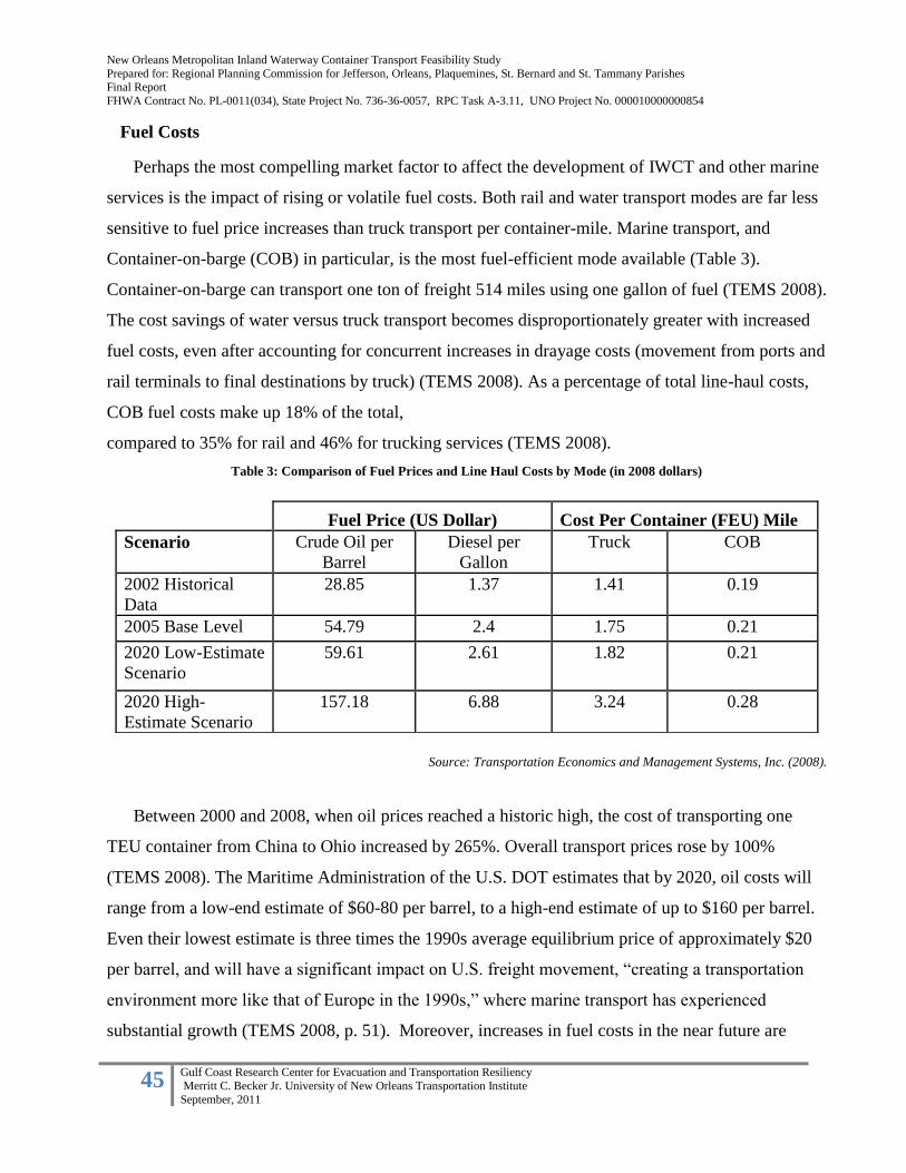
New Orleans Metropolitan Inland Waterway Container Transport Feasibility Study
Prepared for: Regional Planning Commission for Jefferson, Orleans, Plaquemines, St. Bernard and St. Tammany Parishes Final Report
FHWA Contract No. PL-0011(034), State Project No. 736-36-0057, RPC Task A-3.11, UNO Project No. 000010000000854
45 Gulf Coast Research Center for Evacuation and Transportation Resiliency
Merritt C. Becker Jr. University of New Orleans Transportation Institute
September, 2011
Fuel Costs
Perhaps the most compelling market factor to affect the development of IWCT and other marine
services is the impact of rising or volatile fuel costs. Both rail and water transport modes are far less
sensitive to fuel price increases than truck transport per container-mile. Marine transport, and
Container-on-barge (COB) in particular, is the most fuel-efficient mode available (Table 3).
Container-on-barge can transport one ton of freight 514 miles using one gallon of fuel (TEMS 2008).
The cost savings of water versus truck transport becomes disproportionately greater with increased
fuel costs, even after accounting for concurrent increases in drayage costs (movement from ports and
rail terminals to final destinations by truck) (TEMS 2008). As a percentage of total line-haul costs,
COB fuel costs make up 18% of the total,
compared to 35% for rail and 46% for trucking services (TEMS 2008).
Table 3: Comparison of Fuel Prices and Line Haul Costs by Mode (in 2008 dollars)
Source: Transportation Economics and Management Systems, Inc. (2008).
Between 2000 and 2008, when oil prices reached a historic high, the cost of transporting one
TEU container from China to Ohio increased by 265%. Overall transport prices rose by 100%
(TEMS 2008). The Maritime Administration of the U.S. DOT estimates that by 2020, oil costs will
range from a low-end estimate of $60-80 per barrel, to a high-end estimate of up to $160 per barrel.
Even their lowest estimate is three times the 1990s average equilibrium price of approximately $20
per barrel, and will have a significant impact on U.S. freight movement, “creating a transportation
environment more like that of Europe in the 1990s,” where marine transport has experienced
substantial growth (TEMS 2008, p. 51). Moreover, increases in fuel costs in the near future are
Fuel Price (US Dollar) Cost Per Container (FEU) Mile
Scenario Crude Oil per
Barrel
Diesel per
Gallon
Truck COB
2002 Historical
Data
28.85 1.37 1.41 0.19
2005 Base Level 54.79 2.4 1.75 0.21
2020 Low-Estimate
Scenario
59.61 2.61 1.82 0.21
2020 High-
Estimate Scenario
157.18 6.88 3.24 0.28
New Orleans Metropolitan Inland Waterway Container Transport Feasibility Study
Prepared for: Regional Planning Commission for Jefferson, Orleans, Plaquemines, St. Bernard and St. Tammany Parishes Final Report
FHWA Contract No. PL-0011(034), State Project No. 736-36-0057, RPC Task A-3.11, UNO Project No. 000010000000854
46 Gulf Coast Research Center for Evacuation and Transportation Resiliency
Merritt C. Becker Jr. University of New Orleans Transportation Institute
September, 2011
likely to be the result of increasing worldwide demand—a trend which is unlikely to abate—rather
than interruptions in supply, indicating that prices are less and less likely to rebound to previous
(lower) levels (TEMS 2008).
Transport Economics and Management Systems, Inc. (2008) estimates that if fuel prices do
continue to rise, domestic waterborne container traffic is likely to increase by 200-300%, due to the
direct cost advantage, as well as the rail terminal congestion issues previously noted. However, COB
is still likely to serve primarily lower-value container freight, due to its slower shipping times and
the tendency to reduce vessel speeds to maximize fuel efficiency and minimize operating costs.
Time Costs: Congestion and Debottlenecking
As previously noted, rail terminals have become increasingly congested, and many rail corridors
are operating at the limits of their capacity, while highway corridors continue to experience
congestion as well. This results in bottlenecking at intermodal terminals and interchanges, and often
significant delays—sometimes weeks—in overall transit time. U.S. inland waterways are typically
operating significantly under capacity, and thus do not experience congestion delays except at
specific locks located on the upper Mississippi river. This also makes delivery times more reliable
for shippers. These factors increase the relative cost of rail and truck transport, and make alternative
water-based services increasingly more attractive (TEMS 2008; Hanson Professional Services 2007).
B. Policy, Economic and Resiliency Factors
Environmental Policy
Environmental concerns associated with freight transport include air pollution (e.g. sulfur oxides,
carbon oxides, oxides of nitrogen) and, to a lesser extent, noise pollution. Federal environmental
policy impacts the relative costs associated with negative environmental outcomes, and can affect
shippers’ modal choice.
Clear differences exist among modes in the quantity of emissions produced. On a per ton and per
1000 mile basis, marine transport—and barge transport in particular, shows a clear environmental
advantage over rail or truck transportation. (Table 4)

New Orleans Metropolitan Inland Waterway Container Transport Feasibility Study
Prepared for: Regional Planning Commission for Jefferson, Orleans, Plaquemines, St. Bernard and St. Tammany Parishes Final Report
FHWA Contract No. PL-0011(034), State Project No. 736-36-0057, RPC Task A-3.11, UNO Project No. 000010000000854
47 Gulf Coast Research Center for Evacuation and Transportation Resiliency
Merritt C. Becker Jr. University of New Orleans Transportation Institute
September, 2011
Table 4: Emissions by Transportation Mode (Pollutants in lbs produced per ton of cargo per 1000 miles)
Mode Hydrocarbons Carbon monoxide Nitrogen dioxide
Tow boat .09 .20 .53
Train .46 .64 1.83
Truck .63 1.90 10.17
Source: Hanson Professional Services, Inc (2007).
Key federal environmental policies impact freight modal choice. These include the Clean Air Act
Amendments of 1990, which require reductions in the amount of emissions from vehicles and
impose additional control measures in National Ambient Air Quality Standards (NAAQS)
nonattainment areas, while creating a much stronger link between transportation and air quality
control. This initial correlation was reinforced by the passage of the multiyear federal transportation
bill ISTEA in 1991, which developed a policy focus on multimodalism and authorized the
Congestion Mitigation and Air Quality Improvement program (CMAQ), later reauthorized under
TEA-21 in 1998 and SAFETEA-LU in 2005.
CMAQ was originally conceived to fund surface transportation projects which relieve congestion
and help improve air quality. Since its 2005 reauthorization, CMAQ has disbursed nearly $9 billion
to state Departments of Transportation and Metropolitan Planning Organizations for various
transportation projects, congestion mitigation strategies, and emissions reduction efforts (FHA
2011). Funds are disbursed based on state populations, as well as on the degree of air pollution
which must be addressed: states with lower air quality are eligible for more CMAQ funds.
Despite significant gains in air quality and emission reduction overall, air pollution from volatile
organic compounds (VOCs) and fine particulate matter released by combustion engines remains a
significant problem. The EPA estimates that approximately 62 million people were living in air
quality standard nonattainment areas in 1999 (FHA 2011). Of note, vehicle exhaust from both cars
and trucks is one of the most significant contributors to pollution levels, especially in congested
metropolitan areas.

New Orleans Metropolitan Inland Waterway Container Transport Feasibility Study
Prepared for: Regional Planning Commission for Jefferson, Orleans, Plaquemines, St. Bernard and St. Tammany Parishes Final Report
FHWA Contract No. PL-0011(034), State Project No. 736-36-0057, RPC Task A-3.11, UNO Project No. 000010000000854
48 Gulf Coast Research Center for Evacuation and Transportation Resiliency
Merritt C. Becker Jr. University of New Orleans Transportation Institute
September, 2011
According to the Federal Highway Administration, “the most effective CMAQ-funded projects
tend to be large in scope and those that directly affect vehicle emissions” (FHA 2011). Projects
which directly remove cars from the road such as public transit, bike and pedestrian infrastructure
are emphasized in that report. However, a variety of project types such as education campaigns,
technology improvements to enhance system efficiency, inspection programs are eligible for CMAQ
funding, so long as they can be proven to directly improve air quality in a nonattainment or
maintenance area. Highway maintenance, reconstruction, and expansion projects are ineligible, even
if they are intended to relieve congestion. CMAQ funds can be used to fund private enterprises,
under certain circumstances and in partnership with a public agency.
To date, the use of CMAQ funding in marine projects has been limited and largely experimental:
$1.9 million was allocated to the Red Hook Container Barge in New York to purchase a vessel for
Hudson River freight movement, removing 54,000 truck trips annually (FHA 2011). At the Port of
Norfolk, VA, $2.3 million in CMAQ funds were used to expand COB service to Richmond,
relieving interstate congestion in the corridor (Frittelli 2011). However, given the clear
environmental advantages of marine transportation in terms of emissions per ton-mile, this
program’s potential for assisting in the development of inland waterway services, including COB,
should be investigated further.
Of significance to the New Orleans region is the anticipated EPA designation of the area as
nonattainment. The EPA is proposing to revise the 8 hour ozone standard from 0.075 parts per
million (ppm) set in 2008, to a level within the range of 0.060 – 0.070 ppm. Currently the design
values for the monitors at Kenner, Madisonville, Garyville, Hahnville, City Park and Chalmette-
Meraux range from 74 ppm to 69 ppm. (See Table 5) The EPA schedule for making final area
designations is currently set for the end of July, 2011. Moving these areas into a nonattainment
category would allow eligibility for CAMQ funding and potential applications within the marine
transportation sector along the Mississippi River corridor.

New Orleans Metropolitan Inland Waterway Container Transport Feasibility Study
Prepared for: Regional Planning Commission for Jefferson, Orleans, Plaquemines, St. Bernard and St. Tammany Parishes Final Report
FHWA Contract No. PL-0011(034), State Project No. 736-36-0057, RPC Task A-3.11, UNO Project No. 000010000000854
49 Gulf Coast Research Center for Evacuation and Transportation Resiliency
Merritt C. Becker Jr. University of New Orleans Transportation Institute
September, 2011
Table 5: Louisiana 8-Hour Ozone standard monitor levels
Source: Louisiana Department of Environmental Quality
Cargo Volumes and Overweight Factors
Another cost advantage to marine and IWCT service is the elimination of highway weight
limits for truck-based container freight. Intermodal containers are subject to weight limitations of
the weight-bearing capacity between the beginning and end of the over-the-road segment.
Commonly known as “bridge laws,” they are based on the maximum weight that can be supported
by a bridge.
Before leaving port facilities, containers are weighed to assess that they conform with the overall
weight restrictions along the route from the point of origin to the final delivery point. Although in
most cases the container will “cube out” (uses all the space) before it weighs out, there are certain
heavy commodities such as tiles, liquids, and metals that will weigh out leaving unused weight
capacity of the container. For example, although a standard 20 foot has a maximum payload capacity
of 47,885 pounds, the recommended maximum ocean freight payload is 35,000 pounds to
accommodate the added weight of the tractor and chassis and still comply with road weight
restrictions. If this same container were to be transferred from ocean vessel to barge for final
delivery, the cargo payload could have been increased by 13,000 pounds. With the ocean freight rate
remaining the same this would lower the cost per ton to the shipper.

New Orleans Metropolitan Inland Waterway Container Transport Feasibility Study
Prepared for: Regional Planning Commission for Jefferson, Orleans, Plaquemines, St. Bernard and St. Tammany Parishes Final Report
FHWA Contract No. PL-0011(034), State Project No. 736-36-0057, RPC Task A-3.11, UNO Project No. 000010000000854
50 Gulf Coast Research Center for Evacuation and Transportation Resiliency
Merritt C. Becker Jr. University of New Orleans Transportation Institute
September, 2011
A key factor for IWCT to take advantage of unrestricted weight limits per container is the
creation of overweight corridors for servicing industrial and distribution sites. (i.e. very short
distance truck moves from the water to the site). Overweight corridors allow for heavy loads to
move by water and then to a final staging or storage area without incurring the cost of transloading.
As stated earlier, marine carriers can transport containers and general cargoes that greatly exceed the
limits of over-the-road transport.
The Case of Cedar Crossing Business Park and Couch Lines
A case in which overweight infrastructure was created and overweight corridors were
designated is the Cedar Crossing Barge Dock. This facility is located on Cedar Bayou across the
Houston Ship Channel from the Port of Houston’s Barbour’s Cut and Bayport container terminals.
The Cedar Port was opened in 2008 with the goal of attracting shippers of containerized and bulk
goods to move between the Port of Houston complex and the Cedar Crossing Industrial Park. The
industrial park is host to several major distribution centers totaling over five million square feet. The
first client to utilize the overweight corridor connecting the Cedar Port facility was a local plastics
manufacturer who realized the cost advantages of stuffing their containers to the maximum payload
and then barging them to Barbour’s Cut Container Terminal for export. Couch Lines currently
provides container transfer service between Cedar Port terminal and Barbour’s Cut as well as a COB
shuttle service from Houston to New Orleans on an inducement basis. According to the owner,
Couch Lines works directly with the ocean carriers under service agreements to move containers
from one port or terminal to another such as Houston-New Orleans or Barbours Cut-Cedar Port. He
said, “The ocean carrier quotes a rate on a through Bill of Lading and allows the shipper to load the
container to maximum payload at a standard rate for that commodity. Couch Lines rate is built into
the total ocean quote to the shipper, who then pays Couch Lines as it would a trucker or rail line. The
ocean carrier prefers using the water transport mode because it allows them to get a significant
amount of boxes out to one destination in one move”. Another advantage of transporting containers
by water versus truck is that barges can load and discharge at any time of day or night depending on
berth availability, where trucks are restricted by terminal gate hours.

New Orleans Metropolitan Inland Waterway Container Transport Feasibility Study
Prepared for: Regional Planning Commission for Jefferson, Orleans, Plaquemines, St. Bernard and St. Tammany Parishes Final Report
FHWA Contract No. PL-0011(034), State Project No. 736-36-0057, RPC Task A-3.11, UNO Project No. 000010000000854
51 Gulf Coast Research Center for Evacuation and Transportation Resiliency
Merritt C. Becker Jr. University of New Orleans Transportation Institute
September, 2011
Freight Transportation Resilience
The United States economy is dependent upon freight transportation and its ability to deliver
goods from ports to inland points of consumption. A resilient freight transportation system must
have the capability to function as a whole during a disruption caused by significant damage to any
part or parts of its infrastructure. A disruption is an event significant enough to necessitate the
transportation system to operate in a new and altered state. The system can be potentially
overwhelmed for a specific period of time in its ability to adjust to the disrupted situation, as was
demonstrated in New Orleans post-Katrina. Our nation’s freight transportation system is a vital
component of our corporate supply chain, which has enabled significant economic growth over the
past several decades but now needs to adjust to disruptions both locally and, as we’ve recently
learned by the multiple disasters in Japan in 2011, internationally. To accomplish resiliency, the
overall transportation system must be both flexible and redundant.
As a key component to business operations, the transportation system must be flexible and
provide options to switch from one mode to another during any disruption or disaster. According to
Morlok and Chang (2004), a flexible system is able to accommodate changes in demand or traffic
flows without significant declines in performance, regardless of the cause. To measure flexibility,
they define “system capacity flexibility” as the “ability of a transport system to accommodate
variations of changes in traffic demand while maintaining a satisfactory level of performance (p.
406).” Morlok and Chang (2004) cite two principal motivations for their approach to the analysis:
(1) traffic is increasing while transportation infrastructure and capacity are roughly constant; (2)
shifting trade patterns and sourcing strategies, namely a larger number of smaller shipments, are
resulting in different demands on the transport system than were originally intended. However,
neither of these principals take into account the impact of localized or system-wide disruptions
caused by disasters.
As mentioned earlier, the Americas Marine Highway Program identified 11 corridors, 4
connectors and 3 crossings that can serve as extensions of the surface transportation system. The
corridors were identified when water transportation presents an opportunity to offer relief to landside
corridors that suffer from traffic congestion, excessive air emissions or other environmental concerns
and challenges. (MARAD 2011a) The total public benefits of the system can be summarized as
follows: improved air quality, increased freight capacity, fuel savings, reduced highway congestion,
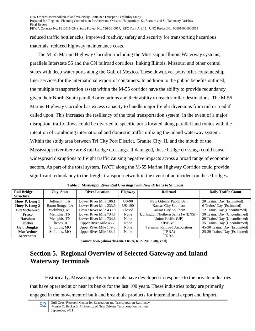
New Orleans Metropolitan Inland Waterway Container Transport Feasibility Study
Prepared for: Regional Planning Commission for Jefferson, Orleans, Plaquemines, St. Bernard and St. Tammany Parishes Final Report
FHWA Contract No. PL-0011(034), State Project No. 736-36-0057, RPC Task A-3.11, UNO Project No. 000010000000854
52 Gulf Coast Research Center for Evacuation and Transportation Resiliency
Merritt C. Becker Jr. University of New Orleans Transportation Institute
September, 2011
reduced traffic bottlenecks, improved roadway safety and security for transporting hazardous
materials, reduced highway maintenance costs.
The M-55 Marine Highway Corridor, including the Mississippi-Illinois Waterway systems,
parallels Interstate 55 and the CN railroad corridors, linking Illinois, Missouri and other central
states with deep water ports along the Gulf of Mexico. These downriver ports offer containership
liner services for the international export of containers. In addition to the public benefits outlined,
the multiple transportation assets within the M-55 corridor have the ability to provide redundancy
given their North-South parallel orientations and their ability to reach similar destinations. The M-55
Marine Highway Corridor has excess capacity to handle major freight diversions from rail or road if
called upon. This increases the resiliency of the total transportation system. In the event of a major
disruption, traffic flows could be diverted to specific ports located along parallel land routes with the
intention of combining international and domestic traffic utilizing the inland waterway system.
Within the study area between Tri City Port District, Granite City, IL and the mouth of the
Mississippi river there are 8 rail bridge crossings. If damaged, these bridge crossings could cause
widespread disruptions to freight traffic causing negative impacts across a broad range of economic
sectors. As part of the total system, IWCT along the M-55 Marine Highway Corridor could provide
significant redundancy to the freight transport network in the event of an incident on these bridges.
Section 5. Regional Overview of Selected Gateway and Inland
Waterway Terminals
Historically, Mississippi River terminals have developed in response to the private industries
that have operated at or near its banks for the last 100 years. These industries today are primarily
engaged in the movement of bulk and breakbulk products for international export and import.
Rail Bridge
Structure
City, State River Location Highway Railroad Daily Traffic Count
Huey P. Long 1
Huey P. Long 2
Old Vicksburd
Frisco
Harahan
Thebes
Gen. Douglas
MacArthur
Merchants
Jefferson, LA
Baton Rouge, LA
Vicksburg, MS
Memphis, TN
Memphis, TN
Thebes, IL
St. Louis, MO
St. Louis, MO
Lower River Mile 106.1
Lower River Mile 233.9
Lower River Mile 437.8
Lower River Mile 734.7
Lower River Mile 734.8
Upper River Mile 43.7
Upper River Mile 179.0
Upper River Mile 183.2
US-90
US-190
Closed
None
None
None
None
None
New Orleans Public Belt
Kansas City Southern
Kansas City Southern
Burlington Northern Santa Fe (BNSF)
Union Pacific (UP)
UP/BNSF
Terminal Railroad Association
(TRRA)
TRRA
20 Trains/ Day (Estimated)
6 Trains/ Day (Estimated)
12 Trains/Day (Unconfirmed)
30 Trains/ Day (Unconfirmed)
20 Trains/ Day (Unconfirmed)
35 Trains/ Day (Unconfirmed)
45-30 Trains/ Day (Estimated)
25-30 Trains/ Day (Estimated)
Table 6: Mississippi River Rail Crossings from New Orleans to St. Louis
Source: www.johnweeks.com, TRRA, KCS, NOPBRR, et al)
New Orleans Metropolitan Inland Waterway Container Transport Feasibility Study
Prepared for: Regional Planning Commission for Jefferson, Orleans, Plaquemines, St. Bernard and St. Tammany Parishes Final Report
FHWA Contract No. PL-0011(034), State Project No. 736-36-0057, RPC Task A-3.11, UNO Project No. 000010000000854
53 Gulf Coast Research Center for Evacuation and Transportation Resiliency
Merritt C. Becker Jr. University of New Orleans Transportation Institute
September, 2011
Currently there is only one major container facility handling significant international traffic within
the Regional Planning Commission’s jurisdiction such as the Port of New Orleans Napoleon Avenue
Container Terminal. Although other concept container terminals for the Lower Mississippi river
have been proposed and reviewed over the years, none have been realized to date.
A high level investigation was recently conducted by UNOTI that included gateway and inland
terminal sites along the Lower and Upper sections of the Mississippi River, conceptual a actual, that
would contribute to the development and or expansion of Inland Waterway Container Transport. The
list of sites was then compiled based on a number of factors. They were also organized into either
gateway or inland port facilities. For the purposes of this study, a gateway port is characterized as
one being located in close proximity to open water shipping lanes and that could handle 500,000
containers or more per year. An inland port is defined as a facility that is located in close proximity
to inland distribution centers and or large consumption markets.
The factors used to determine the suitability of gateway ports were as follows:
Direct access to the Mississippi River and terminal access for barges and or shallow draft
inland container vessels
Volume of international container imports and exports handled (current and projected)
Proximity to international waters and shipping lanes
Container terminal capacity development plans
Commodity Data (current and potential)
origin – destination
types and weights
The factors included in determining the suitability of the inland ports were as follows:
Location outside the lock system
Intermodal connectivity to reach major consumptions markets
Proximity within 15 miles to major highways, rail ramps and distribution facilities
Minimum .25 acres of ground storage per TEU handled
Available acreage for value added activities such as warehousing, stuffing and stripping
facilities, container maintenance and repair.
Amount of new infrastructure construction needed.
The ports and marine facilities included in this study were identified through a process of site
visits, port official interviews and the baseline criteria outlined above. Based upon these factors,
selected ports within the New Orleans region as well as upriver facilities were analyzed as potential
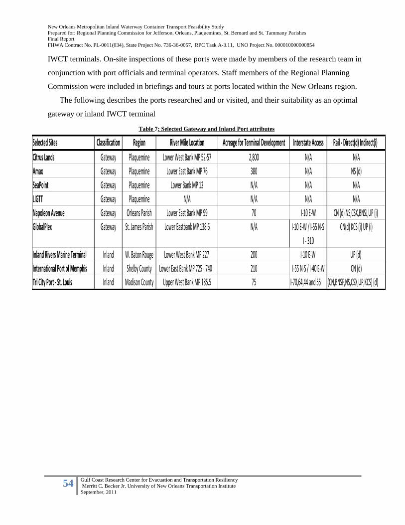
New Orleans Metropolitan Inland Waterway Container Transport Feasibility Study
Prepared for: Regional Planning Commission for Jefferson, Orleans, Plaquemines, St. Bernard and St. Tammany Parishes Final Report
FHWA Contract No. PL-0011(034), State Project No. 736-36-0057, RPC Task A-3.11, UNO Project No. 000010000000854
54 Gulf Coast Research Center for Evacuation and Transportation Resiliency
Merritt C. Becker Jr. University of New Orleans Transportation Institute
September, 2011
IWCT terminals. On-site inspections of these ports were made by members of the research team in
conjunction with port officials and terminal operators. Staff members of the Regional Planning
Commission were included in briefings and tours at ports located within the New Orleans region.
The following describes the ports researched and or visited, and their suitability as an optimal
gateway or inland IWCT terminal
Selected Sites Classification Region River Mile Location Acreage for Terminal Development Interstate Access Rail - Direct(d) Indirect(i)
Citrus Lands Gateway Plaquemine Lower West Bank MP 52-57 2,800 N/A N/A
Amax Gateway Plaquemine Lower East Bank MP 76 380 N/A NS (d)
SeaPoint Gateway Plaquemine Lower Bank MP 12 N/A N/A N/A
LIGTT Gateway Plaquemine N/A N/A N/A N/A
Napoleon Avenue Gateway Orleans Parish Lower East Bank MP 99 70 I-10 E-W CN (d) NS,CSX,BNSJ,UP (i)
GlobalPlex Gateway St. James Parish Lower Eastbank MP 138.6 N/A I-10 E-W / I-55 N-S CN(d) KCS (i) UP (i)
I - 310
Inland Rivers Marine Terminal Inland W. Baton Rouge Lower West Bank MP 227 200 I-10 E-W UP (d)
International Port of Memphis Inland Shelby County Lower East Bank MP 725 - 740 210 I-55 N-S / I-40 E-W CN (d)
Tri City Port - St. Louis Inland Madison County Upper West Bank MP 185.5 75 I-70,64,44 and 55 (CN,BNSF,NS,CSX,UP,KCS) (d)
Table 7: Selected Gateway and Inland Port attributes

New Orleans Metropolitan Inland Waterway Container Transport Feasibility Study
Prepared for: Regional Planning Commission for Jefferson, Orleans, Plaquemines, St. Bernard and St. Tammany Parishes Final Report
FHWA Contract No. PL-0011(034), State Project No. 736-36-0057, RPC Task A-3.11, UNO Project No. 000010000000854
55 Gulf Coast Research Center for Evacuation and Transportation Resiliency
Merritt C. Becker Jr. University of New Orleans Transportation Institute
September, 2011
Figure 12: Gateway Port Locations
Source: Google Earth/ UNOTI
Figure 12 Gateway Port Locations

New Orleans Metropolitan Inland Waterway Container Transport Feasibility Study
Prepared for: Regional Planning Commission for Jefferson, Orleans, Plaquemines, St. Bernard and St. Tammany Parishes Final Report
FHWA Contract No. PL-0011(034), State Project No. 736-36-0057, RPC Task A-3.11, UNO Project No. 000010000000854
56 Gulf Coast Research Center for Evacuation and Transportation Resiliency
Merritt C. Becker Jr. University of New Orleans Transportation Institute
September, 2011
A. The Louisiana International Gulf Transfer Terminal
Contact: John Hyatt @The Irwin Brown Co., Inc.
The Louisiana International Gulf Transfer Terminal (LIGTT) is a concept for a new container
transfer hub located off Southwest Pass at the mouth of the Mississippi River. It is envisioned as the
centerpiece of a new International Supply Chain that would incorporate Central and South American
ports as well as ports along the Gulf of Mexico with an inland waterway transportation system. As
planned, it would use the Mississippi River and other inland waterways systems totaling 14,500
miles to access the 33 states comprising the “US heartland” and 3 Canadian provinces from this new
North American Gateway (LIGTT). It is being promoted both nationally and internationally by LA
State Senator A.G. Crowe and the 17 members of the LIGTT Authority.
Estimated to cost in excess of $1B, the project would establish a new water based supply chain
using the inland waterway systems in the US for short sea shipping and container-on-barge (COB)
transport. LIGTT would be located on state land east of Southwest Pass at the mouth of the
Mississippi River and licensed to private investors. The project would have a natural 80 foot draft
allowing the world’s largest ships to access the facility while requiring no dredging. Smaller feeder
ships as well as COB would transport cargo from LIGTT to both Gulf and inland ports and
Figure 13- Proposed Phase 1 LIGTT Figure 13 Conceptual Rendering LIGTT

New Orleans Metropolitan Inland Waterway Container Transport Feasibility Study
Prepared for: Regional Planning Commission for Jefferson, Orleans, Plaquemines, St. Bernard and St. Tammany Parishes Final Report
FHWA Contract No. PL-0011(034), State Project No. 736-36-0057, RPC Task A-3.11, UNO Project No. 000010000000854
57 Gulf Coast Research Center for Evacuation and Transportation Resiliency
Merritt C. Becker Jr. University of New Orleans Transportation Institute
September, 2011
terminals. The first phase would require a 250 acre footprint. The project could be expanded in the
future stages to include 1,000 acres or more. LIGTT would be fully automated, built at a more than
40’ elevation for storm protection, could incorporate high tech detection devices for use by
Department of Homeland Security and serve as a USCG base of operations. All required manpower
would be accommodated on-site. LIGTT could also provide for value-added facilities. The project is
currently being supported by the Panama Canal Authority.
LIGTT has 5 goals, as stated in their published materials:
1. Re-establish Louisiana as the Gateway to North America
2. Strengthen and grow all of the Ports of Louisiana by focusing on incremental business from
large containerized cargo vessels
3. Serve as the only deep water port in the Gulf of Mexico
4. Open up opportunities for mega distribution centers all along the Mississippi River
5. Position Louisiana as a global destination
LIGTT is predicated on the ever increasing volume of international containerized cargo destined
for North America, the Panama Canal Expansion and the resultant all-water trade route soon to be
used by the largest container ships requiring at minimum 50’ drafts.
Source: Louisiana International Gulf Transfer Terminal Website
Figure 14 LIGTT Distribution Concept
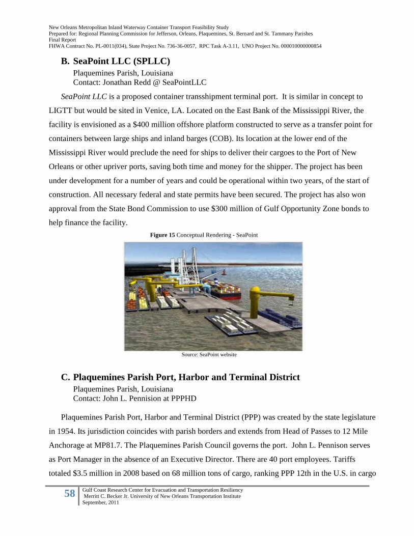
New Orleans Metropolitan Inland Waterway Container Transport Feasibility Study
Prepared for: Regional Planning Commission for Jefferson, Orleans, Plaquemines, St. Bernard and St. Tammany Parishes Final Report
FHWA Contract No. PL-0011(034), State Project No. 736-36-0057, RPC Task A-3.11, UNO Project No. 000010000000854
58 Gulf Coast Research Center for Evacuation and Transportation Resiliency
Merritt C. Becker Jr. University of New Orleans Transportation Institute
September, 2011
B. SeaPoint LLC (SPLLC)
Plaquemines Parish, Louisiana
Contact: Jonathan Redd @ SeaPointLLC SeaPoint LLC is a proposed container transshipment terminal port. It is similar in concept to
LIGTT but would be sited in Venice, LA. Located on the East Bank of the Mississippi River, the
facility is envisioned as a $400 million offshore platform constructed to serve as a transfer point for
containers between large ships and inland barges (COB). Its location at the lower end of the
Mississippi River would preclude the need for ships to deliver their cargoes to the Port of New
Orleans or other upriver ports, saving both time and money for the shipper. The project has been
under development for a number of years and could be operational within two years, of the start of
construction. All necessary federal and state permits have been secured. The project has also won
approval from the State Bond Commission to use $300 million of Gulf Opportunity Zone bonds to
help finance the facility.
C. Plaquemines Parish Port, Harbor and Terminal District
Plaquemines Parish, Louisiana
Contact: John L. Pennision at PPPHD
Plaquemines Parish Port, Harbor and Terminal District (PPP) was created by the state legislature
in 1954. Its jurisdiction coincides with parish borders and extends from Head of Passes to 12 Mile
Anchorage at MP81.7. The Plaquemines Parish Council governs the port. John L. Pennison serves
as Port Manager in the absence of an Executive Director. There are 40 port employees. Tariffs
totaled $3.5 million in 2008 based on 68 million tons of cargo, ranking PPP 12th in the U.S. in cargo
Source: SeaPoint website
Figure 15 Conceptual Rendering - SeaPoint

New Orleans Metropolitan Inland Waterway Container Transport Feasibility Study
Prepared for: Regional Planning Commission for Jefferson, Orleans, Plaquemines, St. Bernard and St. Tammany Parishes Final Report
FHWA Contract No. PL-0011(034), State Project No. 736-36-0057, RPC Task A-3.11, UNO Project No. 000010000000854
59 Gulf Coast Research Center for Evacuation and Transportation Resiliency
Merritt C. Becker Jr. University of New Orleans Transportation Institute
September, 2011
tonnage. Tariffs are used to pay the administrative staff as well as all costs associated with the three
PPP fireboats that are in service at all times.
Although the PPP does not currently have a physical terminal to service the container trade, its
geographical location closer to the mouth of the river serves as the gateway to deep water terminals
along the Lower Mississippi River as well as inland ports within the entire Upper Mississippi Valley
Corridor. Over 5,000 vessels transit thru the PPP annually. Within its boundaries, there are 12
anchorages from Pilottown downriver to the 12 Mile Anchorage, 79 miles upriver, as well as
numerous private terminals. Two of the largest coal terminals in the country are located within the
PPP: International Marine Terminals and TECO Bulk Terminal. These two landside terminals plus
2 mid-streaming terminals give the PPP almost limitless capacity to handle specific commodities.
Primary inbound cargoes include: coke, carbon black feed stock, crude and fuel oil, IC 4, gasoline,
heating oil, naphtha, natural gas, cobalt, petroleum products, phosphate. Outbound cargoes include:
coal and grains (corn, soybean, wheat). All terminals currently serving the PPP are privately owned
and operated.
Over the last 15 years, PPP has been identified by state officials as well as regional port and
maritime interests as a likely location for a large maritime container and intermodal transportation
hub. Originally identified as the Millennium Port, this concept has yet to be realized but it is still
being pursued in various forms by both public and private interests. Two projects in particular are
Figure 16: Kinder Morgan Marine Terminal
Source: Plaquemines Parish Port, Harbor and Terminal District
Figure 16: Kinder Morgan Marine Terminal

New Orleans Metropolitan Inland Waterway Container Transport Feasibility Study
Prepared for: Regional Planning Commission for Jefferson, Orleans, Plaquemines, St. Bernard and St. Tammany Parishes Final Report
FHWA Contract No. PL-0011(034), State Project No. 736-36-0057, RPC Task A-3.11, UNO Project No. 000010000000854
60 Gulf Coast Research Center for Evacuation and Transportation Resiliency
Merritt C. Becker Jr. University of New Orleans Transportation Institute
September, 2011
pursuing investors at the present time. Sea Point is a container transshipment terminal port proposed
for a site in Venice, LA. This terminal has a projected capacity in excess of 900,000 TEUs per year.
Another project currently under development is the Louisiana International Gulf Transfer Terminal
(LIGTT). This $1B terminal, targeted as a private sector investment, intends to reestablish Louisiana
as the Gateway to North America and revitalize inland waterway transportation as the preferred
mode of transportation to access Mid-America (33 states) and 3 Canadian provinces. This near
shore terminal is envisioned as a deep water, 80’ draft, facility located on the eastern edge of
Southwest Pass. The first phase of the project would require 250 acres of facility footprint. However,
to date, neither of these projects has been realized. (See Project Summary)
In light if these fluid development dynamics and competing maritime proposals, the Plaquemines
Parish Council retained Trident Holdings in association with John Vickerman to prepare a,
“Comprehensive Port Development Master Plan for Plaquemines Parish,” in 2009. This recently
completed project considered 10 potential sites for a new multi-modal transportation and distribution
hubs. Based upon their analysis and evaluation 3 sites were selected for further consideration:
1) Citrus II on the Westbank (between MP52 – MP57 with 7000 linear feet of river frontage) 2)
the former AMAX Metal Recovery Inc. property on the Eastbank,
3) the Venice location which would serve the Eastern Gulf Oil + Gas industry as well sports
fishing, eco-tourism and potentially as a Federal and State oil-spill response center.
Both the Citrus Lands and AMAX properties could serve as a COB terminal, however rail service on
the Westbank is severely limited. Other locations that have been considered for a port terminal
complex include the former Freeport Sulphur property at MP 38 and a Boothville site at MP11.
Given its current status as a for sale property and its adjacency to East bank freight rail service
provided by Norfolk Southern RR, the AMEX Nickel Recovery, Inc. facility at 3607 English Turn,
Braithwaite, LA is a prime candidate for a COB terminal. This property, approximately 380 acres, is
currently listed at $11 million with on-site improvements that include multiple industrial buildings
(totaling 66,763 sf), a 52’ x 510 concrete dock, a liquid handling dock, 386,000 sf of pile supported
concrete foundations and an Entergy substation with 2 transformers.
In addition, the Regional Planning Commission conducted a feasibility analysis in 2002 to
review route viability and cost for three proposed rail corridors that would enhance West Jefferson
and Lower Plaquemines industry and potentially serve a new Westbank Plaquemines port site. More
recently there has been interest in extending the existing freight rail corridor to serve lower

New Orleans Metropolitan Inland Waterway Container Transport Feasibility Study
Prepared for: Regional Planning Commission for Jefferson, Orleans, Plaquemines, St. Bernard and St. Tammany Parishes Final Report
FHWA Contract No. PL-0011(034), State Project No. 736-36-0057, RPC Task A-3.11, UNO Project No. 000010000000854
61 Gulf Coast Research Center for Evacuation and Transportation Resiliency
Merritt C. Becker Jr. University of New Orleans Transportation Institute
September, 2011
Plaquemines Westbank by the current owner of the track, the Rio Grande Pacific Corporation, the
New Orleans Public Belt Railroad and others in response to multiple forays by various agencies into
port planning initiatives in lower Plaquemines. The private sector has been risk adverse about
making port investments without assurances of public sector funding to enhance rail access.
However, COB or IWCT concepts would not necessarily require a rail extension into Lower
Plaquemines. Containers could travel by barge or in modern 400 TEU vessels to upriver rail
terminals in close proximity to the Mississippi River that connect products to markets.
D. Port of New Orleans Napoleon Avenue Container Terminal (NACT) New Orleans, Louisiana
Contact: Bobby Landry @ Port of New Orleans
Located on the East Bank of Orleans Parish, at 99.5 AHP, the NACT is a port owned facility
occupying 61 acres of land. The terminal is a shared operation between Ports America Louisiana,
Inc. and New Orleans Terminals, Inc. It includes 2 berths totaling 1,400 linear feet, a 48 acre
marshaling yard and handled 426,091 TEUs in 2010, a 31% increase over 2009. The facility operates
4 multi-purpose gantry cranes as well as 4 rubber tire gantry cranes. It features state-of-the-art
computerized portals at the gate plaza that enable transponder equipped trucks to communicate all
necessary information before accessing the facility. NACT is served by Mediterranean Shipping
Company, Hapag-Lloyd, Maersk, Seaboard Marine and CSAV.
E. Port of South Louisiana (PSL)
Reserve, Louisiana Contact: Linda Prudhomme @ PSL
Source: Port of New Orleans
Figure 17 Napoleon Avenue Container Facility

New Orleans Metropolitan Inland Waterway Container Transport Feasibility Study
Prepared for: Regional Planning Commission for Jefferson, Orleans, Plaquemines, St. Bernard and St. Tammany Parishes Final Report
FHWA Contract No. PL-0011(034), State Project No. 736-36-0057, RPC Task A-3.11, UNO Project No. 000010000000854
62 Gulf Coast Research Center for Evacuation and Transportation Resiliency
Merritt C. Becker Jr. University of New Orleans Transportation Institute
September, 2011
The PSL is the largest tonnage port in the western hemisphere. Its jurisdiction stretches along 54
miles of the Mississippi River with facilities located in St. Charles, St. John, and St. James parishes.
In toto, there are 108 miles of deep-water frontage on both banks of the River that include more than
50 docks and terminals each with a 45’ draft. In 2010, PSL handled over 246 million short tons of
cargo. According to its website “over 4,000 oceangoing vessels and 55,000 barges call at the Port of
South Louisiana each year, making it the top ranked in the country for export tonnage and total
tonnage” accounting for 15% of total US exports and 57% of Louisiana’s exports.
Port-owned facilities include the Globalplex Intermodal Terminal, grain elevators and general
cargo facilities. These facilities are leased to a variety of tenants including Archer Daniels Midland
and Occidental Chemical. However, the majority of terminals and storage facilities are owned and
operated by private sector interests.
PSL also is well served by I-10, 1-55 and I-59 each providing direct highway connections to both
the East and West coasts as well as Mid-America including Chicago, Detroit and St. Paul. State
highways serve as feeders to these interstates. PSL is also served by three Class 1 railroads (CN and
KCS on the East Bank serve Mid America, Canada and Mexico while Union Pacific on the West
Bank serves the western US markets).
In recent years, PSL has promoted a new 7,700 foot dock and container terminal at the Bonnet
Carre Spillway projected to cost a minimum $500 million. If fully developed with value-added
Figure 19 PSL Barge Fleeting and Midstream Operations
Source: Port of S. LA Source: Port of S. LA
Figure 19 GlobalPlex Intermodal Terminal
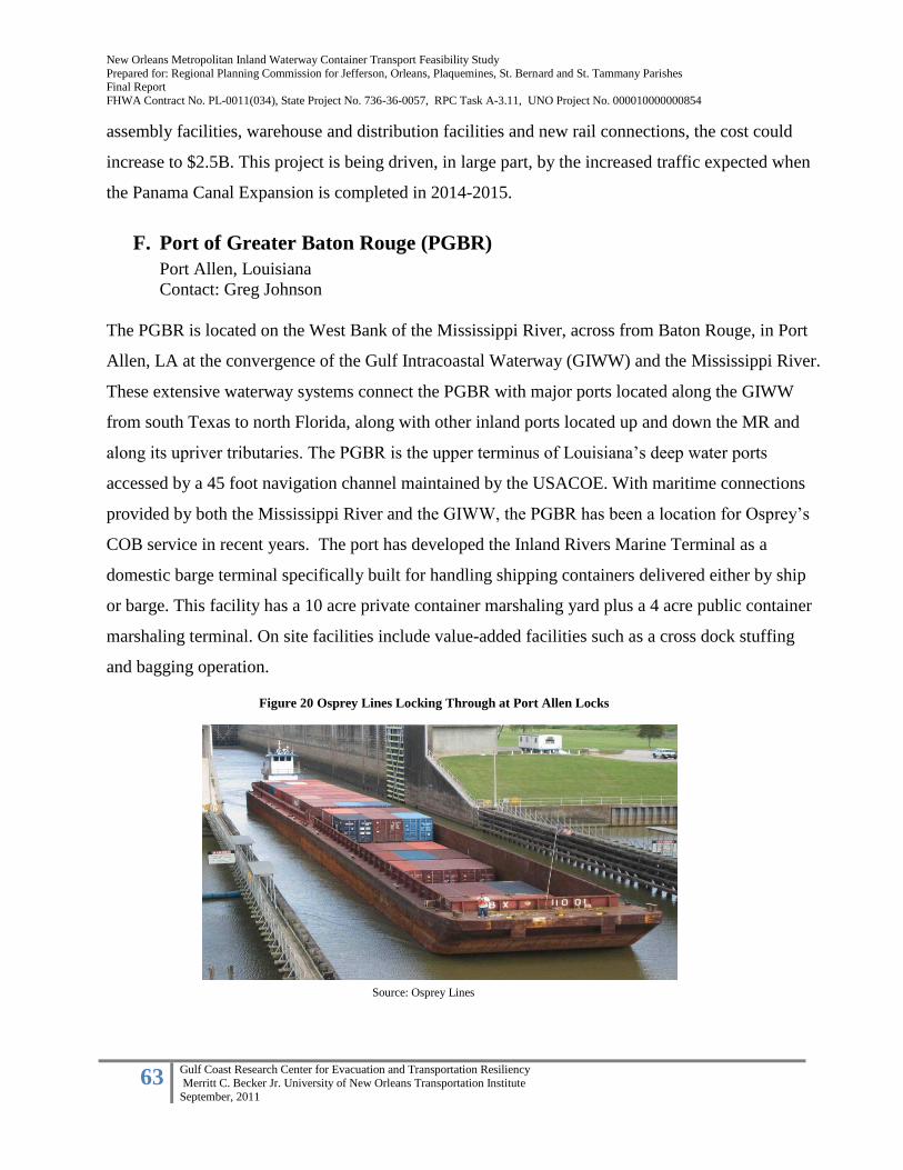
New Orleans Metropolitan Inland Waterway Container Transport Feasibility Study
Prepared for: Regional Planning Commission for Jefferson, Orleans, Plaquemines, St. Bernard and St. Tammany Parishes Final Report
FHWA Contract No. PL-0011(034), State Project No. 736-36-0057, RPC Task A-3.11, UNO Project No. 000010000000854
63 Gulf Coast Research Center for Evacuation and Transportation Resiliency
Merritt C. Becker Jr. University of New Orleans Transportation Institute
September, 2011
Source: Osprey Lines
assembly facilities, warehouse and distribution facilities and new rail connections, the cost could
increase to $2.5B. This project is being driven, in large part, by the increased traffic expected when
the Panama Canal Expansion is completed in 2014-2015.
F. Port of Greater Baton Rouge (PGBR)
Port Allen, Louisiana
Contact: Greg Johnson
The PGBR is located on the West Bank of the Mississippi River, across from Baton Rouge, in Port
Allen, LA at the convergence of the Gulf Intracoastal Waterway (GIWW) and the Mississippi River.
These extensive waterway systems connect the PGBR with major ports located along the GIWW
from south Texas to north Florida, along with other inland ports located up and down the MR and
along its upriver tributaries. The PGBR is the upper terminus of Louisiana’s deep water ports
accessed by a 45 foot navigation channel maintained by the USACOE. With maritime connections
provided by both the Mississippi River and the GIWW, the PGBR has been a location for Osprey’s
COB service in recent years. The port has developed the Inland Rivers Marine Terminal as a
domestic barge terminal specifically built for handling shipping containers delivered either by ship
or barge. This facility has a 10 acre private container marshaling yard plus a 4 acre public container
marshaling terminal. On site facilities include value-added facilities such as a cross dock stuffing
and bagging operation.
Figure 20 Osprey Lines Locking Through at Port Allen Locks

New Orleans Metropolitan Inland Waterway Container Transport Feasibility Study
Prepared for: Regional Planning Commission for Jefferson, Orleans, Plaquemines, St. Bernard and St. Tammany Parishes Final Report
FHWA Contract No. PL-0011(034), State Project No. 736-36-0057, RPC Task A-3.11, UNO Project No. 000010000000854
64 Gulf Coast Research Center for Evacuation and Transportation Resiliency
Merritt C. Becker Jr. University of New Orleans Transportation Institute
September, 2011
The PGBR provides a full range of facilities for the handling and storage of bulk, break bulk,
project and heavy lifts cargo as well as containers. Primary cargoes include: grain, petroleum,
molasses, rail, coils, pipe, various other steel products, liquid and bulk chemicals, building and
construction materials, coal and coke, sugar, containers. The general cargo dock is capable of
handling project cargo and heavy lifts. Roughly 66% of the port’s cargo tonnage is domestic with
the remaining foreign cargoes split 75% import and 25% export.
The actual jurisdiction of the port extends from river mile 168.5 AHP at the Sunshine Bridge
to 253 AHP at the Exxon Mobil Refinery. This is a total of 85 miles along both banks of the
Mississippi River within Ascension, East Baton Rouge, Iberville and West Baton Rouge parishes.
The PGBR, “is located adjacent to I-10 and is in close proximity to US Interstate 12, 49, 55 and 59
and U.S. Highway 61, 65, and 90 and LA Highway 1. The port has daily rail switching services to
the Union Pacific Railroad, Kansas City Southern Railroad, and the Canadian National Railway. The
port has access to all major U.S. truck carriers” (Port of Greater Baton Rouge 2011).
Source: Google Earth with notations per UNOTI
Figure 21: Inland Port Locations

New Orleans Metropolitan Inland Waterway Container Transport Feasibility Study
Prepared for: Regional Planning Commission for Jefferson, Orleans, Plaquemines, St. Bernard and St. Tammany Parishes Final Report
FHWA Contract No. PL-0011(034), State Project No. 736-36-0057, RPC Task A-3.11, UNO Project No. 000010000000854
65 Gulf Coast Research Center for Evacuation and Transportation Resiliency
Merritt C. Becker Jr. University of New Orleans Transportation Institute
September, 2011
G. International Port of Memphis (POM)
Memphis, Tennessee
Contact: Michael Moyer, Operations Manager
The International Port of Memphis is located immediately downriver of Memphis’ Central
Business District. POM’s jurisdictional boundary extends from River Mile 725 to River Mile 740. It
is located 600 river miles upstream of New Orleans and 400 river miles downstream of St. Louis.
POM is the 4th largest inland port in the US with cargoes totaling over 18 million tons annually and
has an annual economic impact in excess of $5 billion. POM is served by 3 still water harbors and
has 5 public terminals.
The POM manages two separate properties. Presidents Island is a 7500 acre property with 1200
acres dedicated to industrial uses with an additional 3000 acres in agricultural use, and a 3300 acre
tract designated as a TN Wildlife Management Area. President’s Island is the POM’s primary
location for maritime users and industrial facilities. The Frank C. Pidgeon Industrial Park (PIP), site
of a potential COB terminal, is an 8100 acre property with 2800 acres available for development
which is located just downriver of President’s Island. Currently, PIP has 1100 acres utilized by
public utilities, 1200 acres used by private industries, and 3300 acres presently undeveloped woods
and fields.
The POM operates as a landlord port with extensive acreage, both developed as industrial
property and undeveloped land used primarily for interim agricultural uses. POM’s primary function
is to manage their facilities and property and maintain flood protection levees within their
jurisdiction. POM President’s Island is served by an 8 mile long still water harbor with a 300’ wide x
9’ deep USACOE maintained channel. Currently 68 of POM’s facilities have harbor frontage. There
are a total of 174 industrial locations on-site including a 53 acre public facility. POM uses as a key
selling feature that it is an ice free facility during winter with no locks or dams between it and the
Gulf of Mexico.
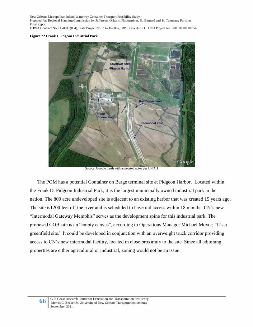
New Orleans Metropolitan Inland Waterway Container Transport Feasibility Study
Prepared for: Regional Planning Commission for Jefferson, Orleans, Plaquemines, St. Bernard and St. Tammany Parishes Final Report
FHWA Contract No. PL-0011(034), State Project No. 736-36-0057, RPC Task A-3.11, UNO Project No. 000010000000854
66 Gulf Coast Research Center for Evacuation and Transportation Resiliency
Merritt C. Becker Jr. University of New Orleans Transportation Institute
September, 2011
Figure 22 Frank C. Pigeon Industrial Park
The POM has a potential Container on Barge terminal site at Pidgeon Harbor. Located within
the Frank D. Pidgeon Industrial Park, it is the largest municipally owned industrial park in the
nation. The 800 acre undeveloped site is adjacent to an existing harbor that was created 15 years ago.
The site is1200 feet off the river and is scheduled to have rail access within 18 months. CN’s new
“Intermodal Gateway Memphis” serves as the development spine for this industrial park. The
proposed COB site is an “empty canvas”, according to Operations Manager Michael Moyer; “It’s a
greenfield site.” It could be developed in conjunction with an overweight truck corridor providing
access to CN’s new intermodal facility, located in close proximity to the site. Since all adjoining
properties are either agricultural or industrial, zoning would not be an issue.
Pigeon Harbor
Laydown Area
Rail Connection
Intermodal Yard
Road
Connection
Pigeon Harbor
Laydown Area
Rail Connection
Intermodal Yard
Road
Connection
Source: Google Earth with annotated notes per UNOTI

New Orleans Metropolitan Inland Waterway Container Transport Feasibility Study
Prepared for: Regional Planning Commission for Jefferson, Orleans, Plaquemines, St. Bernard and St. Tammany Parishes Final Report
FHWA Contract No. PL-0011(034), State Project No. 736-36-0057, RPC Task A-3.11, UNO Project No. 000010000000854
67 Gulf Coast Research Center for Evacuation and Transportation Resiliency
Merritt C. Becker Jr. University of New Orleans Transportation Institute
September, 2011
Fullen Dock and Warehouse (FDW) Memphis, Tennessee
Contact: Lanny Chalk, Terminal Manager
Fullen Dock and Warehouse is a full-service intermodal river terminal and warehousing
facility that provides dock, port, storage and transportation services to the greater Memphis area.
FDW markets themselves as the intermodal transportation provider for the region. Their facilities
are located upriver of the Memphis Central Business District at Mile 740. According to their website
FDW is near the junction of I-40 and I-55 and has open rail access to CSXT, Burlington Northern,
Union Pacific and Norfolk Southern. FDW’s location, in the center of the country, gives the
company the ability to access roughly 75% of the U.S. population by overnight transit. FDW also
offers an on-site trucking partner in Jimmy T. Wood, Inc. to facilitate scheduling and logistics.
Cargo types handled at FDW include: aggregate stone, limestone, bulk materials, plate steel,
ferroalloys, heavy lifts and oversized cargo, structural steel and steel coils, super sacks, container-
on-barge.
Source: Osprey Lines Source: Osprey Lines
Figure 24 Fullen Dock Floating Barge Figure 23 Fullen Dock-ramp
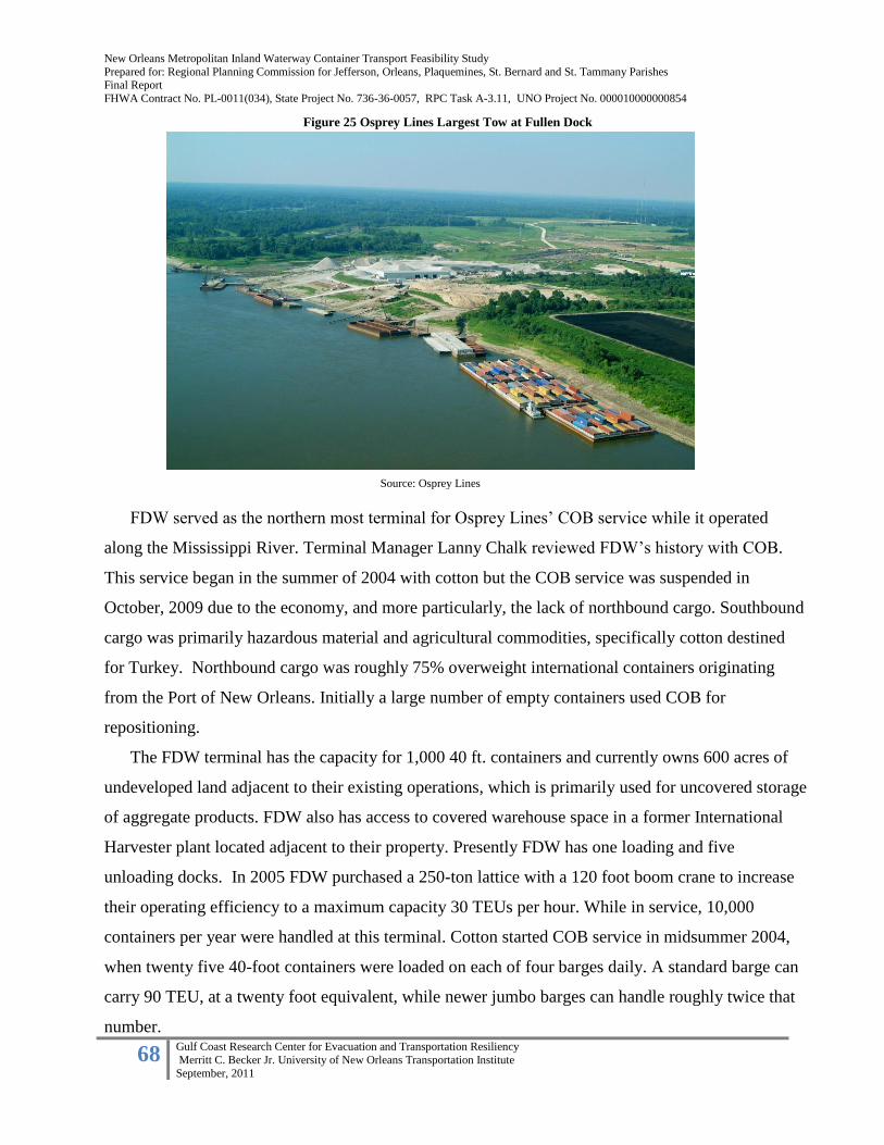
New Orleans Metropolitan Inland Waterway Container Transport Feasibility Study
Prepared for: Regional Planning Commission for Jefferson, Orleans, Plaquemines, St. Bernard and St. Tammany Parishes Final Report
FHWA Contract No. PL-0011(034), State Project No. 736-36-0057, RPC Task A-3.11, UNO Project No. 000010000000854
68 Gulf Coast Research Center for Evacuation and Transportation Resiliency
Merritt C. Becker Jr. University of New Orleans Transportation Institute
September, 2011
FDW served as the northern most terminal for Osprey Lines’ COB service while it operated
along the Mississippi River. Terminal Manager Lanny Chalk reviewed FDW’s history with COB.
This service began in the summer of 2004 with cotton but the COB service was suspended in
October, 2009 due to the economy, and more particularly, the lack of northbound cargo. Southbound
cargo was primarily hazardous material and agricultural commodities, specifically cotton destined
for Turkey. Northbound cargo was roughly 75% overweight international containers originating
from the Port of New Orleans. Initially a large number of empty containers used COB for
repositioning.
The FDW terminal has the capacity for 1,000 40 ft. containers and currently owns 600 acres of
undeveloped land adjacent to their existing operations, which is primarily used for uncovered storage
of aggregate products. FDW also has access to covered warehouse space in a former International
Harvester plant located adjacent to their property. Presently FDW has one loading and five
unloading docks. In 2005 FDW purchased a 250-ton lattice with a 120 foot boom crane to increase
their operating efficiency to a maximum capacity 30 TEUs per hour. While in service, 10,000
containers per year were handled at this terminal. Cotton started COB service in midsummer 2004,
when twenty five 40-foot containers were loaded on each of four barges daily. A standard barge can
carry 90 TEU, at a twenty foot equivalent, while newer jumbo barges can handle roughly twice that
number.
Source: Osprey Lines
Figure 25 Osprey Lines Largest Tow at Fullen Dock

New Orleans Metropolitan Inland Waterway Container Transport Feasibility Study
Prepared for: Regional Planning Commission for Jefferson, Orleans, Plaquemines, St. Bernard and St. Tammany Parishes Final Report
FHWA Contract No. PL-0011(034), State Project No. 736-36-0057, RPC Task A-3.11, UNO Project No. 000010000000854
69 Gulf Coast Research Center for Evacuation and Transportation Resiliency
Merritt C. Becker Jr. University of New Orleans Transportation Institute
September, 2011
According to Mr. Chalk, steamships need to be the prime force behind the COB service if this
alternative mode of transport is to succeed. Osprey did a lot of business with MSC Industrial Supply
Company and Seaboard Marine in New Orleans. Mr. Chalk feels that steamship lines are important
because they have existing partnerships with the railroads to deliver northbound traffic. The COB
cost per container is $50 - $100 less than rail. Truck rates are twice that of rail per box. “It is very
important that a market niche be found, such as hazmat cargoes, project cargo, or overweight
containers. Then COB will work.” Historically, export markets were primarily European. He noted
that reliability is a key variable. In addition, barge services can offer operating flexibility since they
can function during off hours. Tax credits, regulations on hazmat cargo or other external factors
could be used as incentives. When asked if he would restart COB, he replied “we could be back in
operation in 15 minutes, if the market was there. We liked the business.” Finally, he believes a key
to the success of COB is to use large volumes or blocks of specific destination cargoes loaded as
such on the carriers.
H. Americas Central Port –Tri-City Regional Port District
Granite City, IL
Contact: Dennis Wilmsmeyer, Executive Director
America’s Central Port (ACP) is a 1,200-acre facility located in southwestern Illinois across
from St. Louis, MO. It is managed by the Tri-City Regional Port District, a special purpose unit of
local government for the State of Illinois. Strategically located in the heart of the U.S. on the
Mississippi River, the port is primarily an export barge port with a 6,000 foot harbor moving
outbound steel and grain destined for New Orleans and asphalt inbound for the Greater St. Louis
Region. The Tri-City Regional Port Distrtic (TCRPD) currently handles 3.5 – 4 million tons of cargo
per year using river barges, rail cars and trucks. The harbor currently serves 2,500 barges annually.
TCRPD has bulk liquid, dry bulk, general cargo, steel and fertilizer terminals on-site.
ACP holds the license and Grant of Authority for Foreign Trade Zone #31 consisting of 500
acres on-site as well as several off-site locations. As such, ACP is a gated facility with around the
clock security. It currently serves as the mid-continental intermodal transportation hub for dry and
liquid bulk products and general cargo.
The port was established in 2002 as part of a federal conveyance. It currently occupies 1,200
acres, of which 600 acres are undeveloped. It includes 1.7 million square feet of warehouse space,
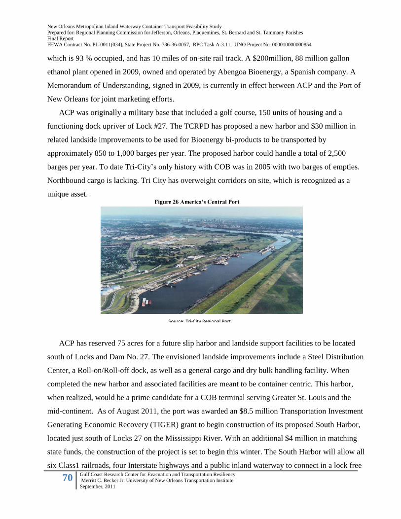
New Orleans Metropolitan Inland Waterway Container Transport Feasibility Study
Prepared for: Regional Planning Commission for Jefferson, Orleans, Plaquemines, St. Bernard and St. Tammany Parishes Final Report
FHWA Contract No. PL-0011(034), State Project No. 736-36-0057, RPC Task A-3.11, UNO Project No. 000010000000854
70 Gulf Coast Research Center for Evacuation and Transportation Resiliency
Merritt C. Becker Jr. University of New Orleans Transportation Institute
September, 2011
which is 93 % occupied, and has 10 miles of on-site rail track. A $200million, 88 million gallon
ethanol plant opened in 2009, owned and operated by Abengoa Bioenergy, a Spanish company. A
Memorandum of Understanding, signed in 2009, is currently in effect between ACP and the Port of
New Orleans for joint marketing efforts.
ACP was originally a military base that included a golf course, 150 units of housing and a
functioning dock upriver of Lock #27. The TCRPD has proposed a new harbor and $30 million in
related landside improvements to be used for Bioenergy bi-products to be transported by
approximately 850 to 1,000 barges per year. The proposed harbor could handle a total of 2,500
barges per year. To date Tri-City’s only history with COB was in 2005 with two barges of empties.
Northbound cargo is lacking. Tri City has overweight corridors on site, which is recognized as a
unique asset.
ACP has reserved 75 acres for a future slip harbor and landside support facilities to be located
south of Locks and Dam No. 27. The envisioned landside improvements include a Steel Distribution
Center, a Roll-on/Roll-off dock, as well as a general cargo and dry bulk handling facility. When
completed the new harbor and associated facilities are meant to be container centric. This harbor,
when realized, would be a prime candidate for a COB terminal serving Greater St. Louis and the
mid-continent. As of August 2011, the port was awarded an $8.5 million Transportation Investment
Generating Economic Recovery (TIGER) grant to begin construction of its proposed South Harbor,
located just south of Locks 27 on the Mississippi River. With an additional $4 million in matching
state funds, the construction of the project is set to begin this winter. The South Harbor will allow all
six Class1 railroads, four Interstate highways and a public inland waterway to connect in a lock free
North Harbor area
South Harbor area
Source: Tri-City Regional Port District
Figure 26 America’s Central Port

New Orleans Metropolitan Inland Waterway Container Transport Feasibility Study
Prepared for: Regional Planning Commission for Jefferson, Orleans, Plaquemines, St. Bernard and St. Tammany Parishes Final Report
FHWA Contract No. PL-0011(034), State Project No. 736-36-0057, RPC Task A-3.11, UNO Project No. 000010000000854
71 Gulf Coast Research Center for Evacuation and Transportation Resiliency
Merritt C. Becker Jr. University of New Orleans Transportation Institute
September, 2011
environment. Delays caused by bottlenecks around the locks and dams will be eliminated allowing
much faster transfers of cargo between barges and landside modes.
Located immediately upriver on the Illinois side of the Mississippi River, ACP serves the
greater St. Louis area, a regional distribution hub. For port facilities, the Missouri side of the river is
landlocked so the only growth option is on the Illinois side. St. Louis is served by five Class 1
railroads as well as a terminal railroad which owns both bridges crossing over the Mississippi River.
Gateway Commerce Center has been recently developed as a major distribution hub several miles
east of ACP.
Source: Americas Central Port Website
Figure 27 Conceptual Rendering of South Harbor Facility Improvement Project
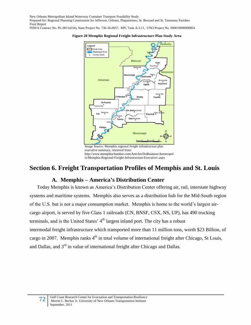
New Orleans Metropolitan Inland Waterway Container Transport Feasibility Study
Prepared for: Regional Planning Commission for Jefferson, Orleans, Plaquemines, St. Bernard and St. Tammany Parishes Final Report
FHWA Contract No. PL-0011(034), State Project No. 736-36-0057, RPC Task A-3.11, UNO Project No. 000010000000854
72 Gulf Coast Research Center for Evacuation and Transportation Resiliency
Merritt C. Becker Jr. University of New Orleans Transportation Institute
September, 2011
Section 6. Freight Transportation Profiles of Memphis and St. Louis
A. Memphis – America’s Distribution Center
Today Memphis is known as America’s Distribution Center offering air, rail, interstate highway
systems and maritime systems. Memphis also serves as a distribution hub for the Mid-South region
of the U.S. but is not a major consumption market. Memphis is home to the world’s largest air-
cargo airport, is served by five Class 1 railroads (CN, BNSF, CSX, NS, UP), has 490 trucking
terminals, and is the United States’ 4th
largest inland port. The city has a robust
intermodal freight infrastructure which transported more than 11 million tons, worth $23 Billion, of
cargo in 2007. Memphis ranks 4th
in total volume of international freight after Chicago, St Louis,
and Dallas, and 3rd
in value of international freight after Chicago and Dallas.
Image Source: Memphis regional freight infrastructure plan
executive summary, retrieved from:
http://www.memphischamber.com/Articles/DoBusiness/Aerotropolis/Memphis-Regional-Freight-Infrastructure-Executive-.aspx
Figure 28 Memphis Regional Freight Infrastructure Plan Study Area

New Orleans Metropolitan Inland Waterway Container Transport Feasibility Study
Prepared for: Regional Planning Commission for Jefferson, Orleans, Plaquemines, St. Bernard and St. Tammany Parishes Final Report
FHWA Contract No. PL-0011(034), State Project No. 736-36-0057, RPC Task A-3.11, UNO Project No. 000010000000854
73 Gulf Coast Research Center for Evacuation and Transportation Resiliency
Merritt C. Becker Jr. University of New Orleans Transportation Institute
September, 2011
Table 8: Total International Land and Water Trade in Memphis Region, 2007
Imports Exports Total
Tons in millions 6.21 4.99 11.20
Value in billions $16.9 $6.3 $23.1
Table data source: IHS global insight United States Inland Trade Monitor
The rail industry has invested over $500 Million in intermodal rail infrastructure in the region,
and intermodal rail traffic is expected to double to over 2 million containers from 2007 to 2035. The
Memphis area has a total of 19 intermodal freight terminals, four are rail-truck terminals, 12 are rail-
truck-marine terminals, and three are air-truck terminals at Memphis International Airport.
Memphis imports substantial goods from the Pacific Rim from the ports of Los Angeles and Long
Beach, and exports bulk commodities through the Port of New Orleans and higher-value goods
through East Coast ports to Europe. Container traffic dynamics, by sea and land, are expected to
shift somewhat as a result of the expansion of the Panama Canal by 2015. This could result in up to a
25% decline in West Coast container traffic, and consequent increases in Gulf and East Coast ports,
as well as offshore and Caribbean port facilities. This may decrease Memphis’ logistic
competitiveness as a major transfer hub.
Despite today’s economic recession and unpredictable fuel costs, air freight has remained a
critical component of Memphis’ freight industry, serving as the hub of Fed Ex, for the transport of
high-value and time-sensitive cargo. Overall, however, the economic recession has led to increases
in rail and water transport, and declines in air and truck transport.
Marine Transportation:
Within the Memphis region there are 99 Mississippi River port terminals, 62 of which are
within the International Port of Memphis. In 2007, this port system transported 21 Million tons of
international and domestic freight.
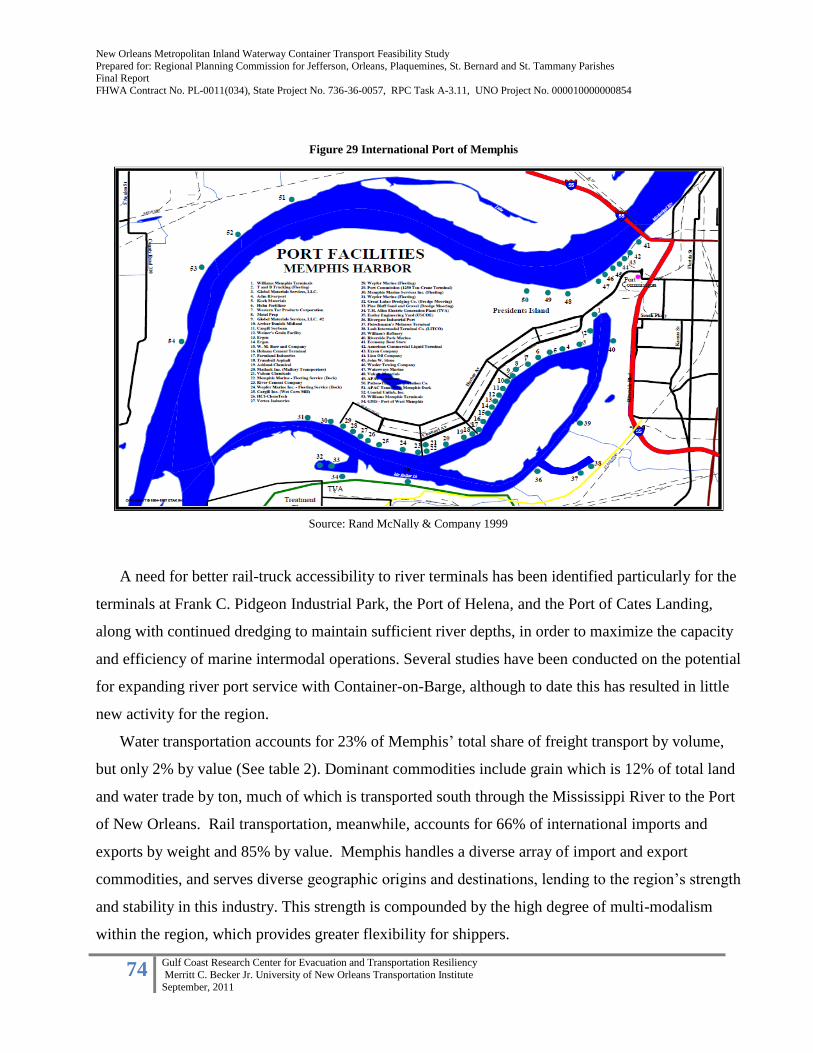
New Orleans Metropolitan Inland Waterway Container Transport Feasibility Study
Prepared for: Regional Planning Commission for Jefferson, Orleans, Plaquemines, St. Bernard and St. Tammany Parishes Final Report
FHWA Contract No. PL-0011(034), State Project No. 736-36-0057, RPC Task A-3.11, UNO Project No. 000010000000854
74 Gulf Coast Research Center for Evacuation and Transportation Resiliency
Merritt C. Becker Jr. University of New Orleans Transportation Institute
September, 2011
A need for better rail-truck accessibility to river terminals has been identified particularly for the
terminals at Frank C. Pidgeon Industrial Park, the Port of Helena, and the Port of Cates Landing,
along with continued dredging to maintain sufficient river depths, in order to maximize the capacity
and efficiency of marine intermodal operations. Several studies have been conducted on the potential
for expanding river port service with Container-on-Barge, although to date this has resulted in little
new activity for the region.
Water transportation accounts for 23% of Memphis’ total share of freight transport by volume,
but only 2% by value (See table 2). Dominant commodities include grain which is 12% of total land
and water trade by ton, much of which is transported south through the Mississippi River to the Port
of New Orleans. Rail transportation, meanwhile, accounts for 66% of international imports and
exports by weight and 85% by value. Memphis handles a diverse array of import and export
commodities, and serves diverse geographic origins and destinations, lending to the region’s strength
and stability in this industry. This strength is compounded by the high degree of multi-modalism
within the region, which provides greater flexibility for shippers.
Figure 29 International Port of Memphis
Source: Rand McNally & Company 1999

New Orleans Metropolitan Inland Waterway Container Transport Feasibility Study
Prepared for: Regional Planning Commission for Jefferson, Orleans, Plaquemines, St. Bernard and St. Tammany Parishes Final Report
FHWA Contract No. PL-0011(034), State Project No. 736-36-0057, RPC Task A-3.11, UNO Project No. 000010000000854
75 Gulf Coast Research Center for Evacuation and Transportation Resiliency
Merritt C. Becker Jr. University of New Orleans Transportation Institute
September, 2011
Table 9: Total International Land and Water Trade in the Memphis Region by Mode 2007
Mode Tons in millions Share Value in billions share
Rail 7.7 69% $19.8 85%
Truck .9 8% $2.8 12%
Water 2.6 23% $.5 2%
Total 11.2 100% $23.1 100% Source: IHS global insight United States Inland Trade Monitor
Broken down into import and export categories, water transport accounts for 13% of imports by
volume but only 1% of imports by value, and 38% of exports by volume and 6% of exports by value
(Tables 3 and 4). Bulk commodities moving through the Port of New Orleans account for this
discrepancy, as higher-value exports tend to be transported by rail to East and West Coast ports for
shipment. Overall, there is an imbalance between import and export trade in the region. Memphis is
a net importer of goods, resulting in an availability of empty containers and equipment which must
be repositioned. Containerization in Memphis, as elsewhere, is on the rise. However, only 10% of
water imports and a negligible percentage of water exports were containerized as of 2007 (Table 5).
Table 10: Total International Land and Water imports in the Memphis Region by Mode 2007
Mode Tons in millions Share Value in billions Share
Rail 4.82 78% $14.48 86%
Truck .58 10% $2.24 13%
Water .78 13% $.16 1%
Total 6.19 100% $16.87 100% Source: IHS global insight United States Inland Trade Monitor
Table 11: Total International Land and Water Exports in the Memphis Region by Mode 2007
Mode Tons in millions Share Value in billions Share
Rail 2.84 58% $5.29 85%
Truck .29 6% $.57 9%
Water 1.84 38% $.39 6%
Total 4.98 100% $6.25 100% Source: IHS global insight United States Inland Trade Monitor

New Orleans Metropolitan Inland Waterway Container Transport Feasibility Study
Prepared for: Regional Planning Commission for Jefferson, Orleans, Plaquemines, St. Bernard and St. Tammany Parishes Final Report
FHWA Contract No. PL-0011(034), State Project No. 736-36-0057, RPC Task A-3.11, UNO Project No. 000010000000854
76 Gulf Coast Research Center for Evacuation and Transportation Resiliency
Merritt C. Becker Jr. University of New Orleans Transportation Institute
September, 2011
Table 12: Percent of Imports and Exports Containerized by Mode 2007
Mode % of Imports Containerized % of Exports Containerized
Rail 87% 74%
Truck 65% 47%
Water 10% 3% Source: Memphis Regional Freight Infrastructure Plan
REFERENCE:
Global Insight (2009). Memphis Regional Freight Transportation Plan. Retrieved from:
http://www.memphischamber.com/Articles/DoBusiness/Aerotropolis/Memphis-Regional-Freight-Infrastructure-Plan-March.aspx
B. St. Louis Metro Area
The St. Louis Metropolitan Area is situated close to the geographic center of the U.S. Located
within 500 miles of 1/3 of the U.S. population and within 1,500 miles of 90% of North America’s
population and GDP the St. Louis Metropolitan Area is ideally situated as an intermodal distribution
hub. In 2007, Expansion Management ranked St. Louis # 2 of the “Top 10 Logistics Metros” in the
U.S. Additionally, St. Louis’ freight market is well balanced between imports and exports, reducing
the need for repositioning of empty railcars, trailers and containers. Over the last five years,
intermodal cargo, by the ton, has grown by 66%, compared to a national growth rate of 40%
(Gateway Commerce Center 2011).
The St. Louis Metropolitan Area is served by “an unsurpassed transportation infrastructure”,
according to a recent report sponsored by Ameren Economic Development. This report,
“Competitive Marketing Analysis – Wholesale Trade” is an analysis of Sector 42 of the North
American Industry Classification System, which the consultant team defines as “the management
and movement of materials in large volumes, mostly among business and industrial facilities, before
they are sold to the retail customer” (Ameren Economic Development, ND, p. 3). In the metro St.
Louis region, Sector 42 represents “roughly 60,000 people that are employed in over 4,000
establishments that occupy 12 million square feet of distribution and warehouse space” (Ameren
Economic Development, ND, p. 3). This report stresses the region’s transportation infrastructure as a
key asset. With its extensive interstate and highway network in good repair, minimal levels of
congestion, service by all Class 1 railroads, an international airport that handles over 210,000 tons of
air cargo annually, several regional airports, a number of intermodal terminals that service rail to
truck transfer, as well as diversified maritime facilities including both public and private terminals,
the region is in a good shape. What is most significant, according to Ameren’s consultants, is that
these individual transportation assets work as a comprehensive and mutually supportive network.
New Orleans Metropolitan Inland Waterway Container Transport Feasibility Study
Prepared for: Regional Planning Commission for Jefferson, Orleans, Plaquemines, St. Bernard and St. Tammany Parishes Final Report
FHWA Contract No. PL-0011(034), State Project No. 736-36-0057, RPC Task A-3.11, UNO Project No. 000010000000854
77 Gulf Coast Research Center for Evacuation and Transportation Resiliency
Merritt C. Becker Jr. University of New Orleans Transportation Institute
September, 2011
Taken altogether, the region serves as a storage, transfer, and distribution point for domestic and
international cargo with origins and destinations on all North American coasts with connections to
both Canada and Mexico. The St. Louis area ranks 10th
in the US for originating shipments and 12th
for received shipments with significantly more outbound shipments than inbound.
The Metropolitan Port of St Louis is composed of six separate port authorities. There are three
authorities in Illinois: Tri-City Regional Port District, Kaskaskia Regional Port District and
Southwest Regional Port District. Three more authorities in Missouri: Jefferson County Port
Authority, St. Louis County Port Authority, and City of St. Louis Port Authority. The resulting
Metropolitan Port covers 70 linear miles of the Mississippi river extending from the southern border
of Jefferson County, MO to the northern border of Madison County, Il. The St. Louis region
encompasses the Mississippi, Missouri, and Illinois rivers. It is the nation’s second largest inland
port by servicing over 24 billion trip ton-miles per year and the third largest inland port by tonnage,
servicing over 31 million tons per year. Inland waterways play a significant role in the transportation
of bulk commodities to the St. Louis region; Illinois has 1,095 miles of commercially navigable
waterways while Missouri has 1,033 miles. These waterways connect St. Louis to the Gulf of
Mexico from the Mississippi, to Kansas City and Sioux City through the Missouri River and Peoria-
Chicago- the Great Lakes- St. Lawrence Seaway through the Illinois River.
The Metropolitan Port of St Louis includes more than 130 primarily private docks and terminals,
55 barge fleeting areas, and is the northernmost year-round ice-free Mississippi River port. South of
St. Louis, the Mississippi River offers unimpeded access to New Orleans and the Gulf, with no
locks or dams. (Hook 2005). The St. Louis Metropolitan Area also includes two foreign trade zone
(FTZ) sites which provide economic benefits to shippers operating within their boundaries including
duty reduction or elimination and simplified customs procedures.
The City of St. Louis Port Authority encompasses nearly 20 miles of the Mississippi River above
the confluence of the Ohio River. It includes 16 terminals with direct access to four major interstates
and six Class 1 rail lines. Nick Nichols, operations manager for the St. Louis Port Authority, notes
that the ability to transport heavy commodities by waterway results in substantial savings for
shippers, giving St. Louis a competitive advantage (Hook 2005).
The St. Louis intermodal freight network is enhanced by a variety of Distribution Centers.
These include the Gateway Commerce Center, a 2,300 acre warehouse and distribution hub, whose
tenants include Hersey, Unilever, Procter & Gamble, Dial and Save-A-Lot. Support infrastructure

New Orleans Metropolitan Inland Waterway Container Transport Feasibility Study
Prepared for: Regional Planning Commission for Jefferson, Orleans, Plaquemines, St. Bernard and St. Tammany Parishes Final Report
FHWA Contract No. PL-0011(034), State Project No. 736-36-0057, RPC Task A-3.11, UNO Project No. 000010000000854
78 Gulf Coast Research Center for Evacuation and Transportation Resiliency
Merritt C. Becker Jr. University of New Orleans Transportation Institute
September, 2011
includes high capacity electric, natural gas, water, sewer and telecommunication systems. All
internal roads are designed to interstate standards, with a 40 ton vehicle rating. Tenants and owner
occupants have access to highway, rail, air, and water transport facilities. The adjacent Triple Crown
Services Co. is a 62 acre intermodal commercial distribution facility (Gateway Commerce Center
2011).
Section 7. Findings & Conclusions Over the last several decades a number of ventures have offered regular IWCT services using
facilities along the Mississippi River for landside terminals and support infrastructure. Currently, no
company offers a regular service for IWCT on the river. After an exhaustive investigation of
physical and market conditions within the region and along the Mississippi River Trade Corridor, we
conclude that the basic deterrents to IWCT are related to market conditions and not the physical
support infrastructure.
Landside infrastructure exists at several ports within the New Orleans region, as well as upriver
within the unlocked portions of the river, to support IWCT. The Port of New Orleans has existing
infrastructure in place to service IWCT at their Napoleon Avenue Container Terminal. The Port of
South Louisiana, at its GlobalPlex location, has adequate infrastructure available for IWCT, but
insufficient on-dock container storage at the present time. The Port of Greater Baton Rouge
currently includes the Inland Rivers Marine Terminal specifically designed and constructed to serve
IWCT. This facility features a barge dock, a four acre container marshaling yard and a 42,000 ft2 rail
served warehouse. Upriver, in Memphis, there are two existing terminals previously used for IWCT
as well as an undeveloped site suitable for an IWCT facility at the Frank C. Pidgeon Industrial Park.
In the St. Louis area, a barge harbor is currently under construction at the Tri-City Regional Port
District. This clearly demonstrates that adequate infrastructure exists within the unlocked portion of
the Mississippi River to support IWCT.
There also exists in the New Orleans region several potential “greenfield sites” suitable for
IWCT terminals. These include the former AMAX Nickel refinery at milepost 76 on the east bank of
Plaquemines Parish as well as a west bank location at roughly mile marker 46. Within the Port of
South Louisiana, there is ongoing discussion about the development of a container terminal at the
Bonne Carre spillway located between mileposts 127 to 129 on the east bank.

New Orleans Metropolitan Inland Waterway Container Transport Feasibility Study
Prepared for: Regional Planning Commission for Jefferson, Orleans, Plaquemines, St. Bernard and St. Tammany Parishes Final Report
FHWA Contract No. PL-0011(034), State Project No. 736-36-0057, RPC Task A-3.11, UNO Project No. 000010000000854
79 Gulf Coast Research Center for Evacuation and Transportation Resiliency
Merritt C. Becker Jr. University of New Orleans Transportation Institute
September, 2011
Unbalanced trade flows and inadequate container volumes are two big challenges for the success
of IWCT on the Mississippi River. Previous services have failed primarily due to two separate but
related issues. Downriver container volumes were sufficient to support IWCT but the lack of upriver
container traffic created an unbalanced trade flow. Furthermore, the general lack of container
movements along the Mississippi Trade Corridor remains a challenge for all transportation modes.
However, these conditions may soon change given the expansion of the Panama Canal in 2014 and
the potential development of two proposed transfer terminals at or near the mouth of the river. One
or more of these developments may create the upriver container volume necessary to support IWCT
on the Mississippi River and create a more balanced trade flow along the river. They could also
contribute to a “multi-port gateway system” within 100 miles of the Gulf of Mexico along the
Mississippi river to accumulate a critical mass of international containers (1M+/year). This is
imperative for IWCT to be successful using the river and its tributaries. By comparison, both
Rotterdam and Antwerp are located within a 50 mile distance to open waters of the North Sea and
together handle over 3 million containers.
At the regional, state and national levels of government, there has been insufficient support for
policies and programs that will influence a modal shift of cargo transportation movements from land
to water. Europe has robust policies in place, supported by financial structures, that purposefully
shift cargo from land to water. To date, this has not happened in a serious and sustained manner in
the US. Consequently, positive success stories of US IWCT services are few and their total impacts,
to date, have been minimal on the overall surface transportation networks serving the nation.
External factors may also cause this modal shift in the US. These include the cost of fuel, air
quality standards and increasing levels of congestion on both the rail and road networks.
Macroeconomics may also influence the growth of international trade. Each of these will play an
incremental role in the sustained development and growth of IWCT along the Mississippi River and
within the nation’s inland waterway system.
A final benefit of IWCT is its ability to act as a redundant surface transportation network
in the event of a major road or rail disruption. IWCT can provide an additional and
complementary mode to the nation’s surface transportation system in times of natural or
manmade disaster.
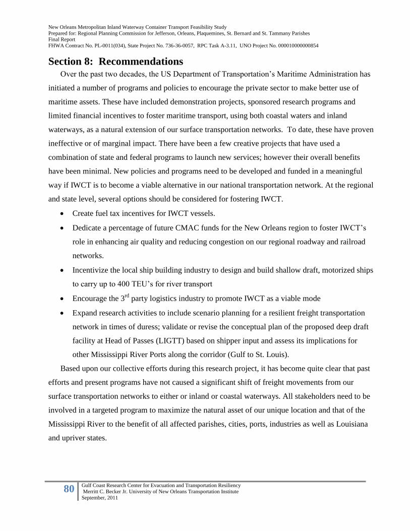
New Orleans Metropolitan Inland Waterway Container Transport Feasibility Study
Prepared for: Regional Planning Commission for Jefferson, Orleans, Plaquemines, St. Bernard and St. Tammany Parishes Final Report
FHWA Contract No. PL-0011(034), State Project No. 736-36-0057, RPC Task A-3.11, UNO Project No. 000010000000854
80 Gulf Coast Research Center for Evacuation and Transportation Resiliency
Merritt C. Becker Jr. University of New Orleans Transportation Institute
September, 2011
Section 8: Recommendations Over the past two decades, the US Department of Transportation’s Maritime Administration has
initiated a number of programs and policies to encourage the private sector to make better use of
maritime assets. These have included demonstration projects, sponsored research programs and
limited financial incentives to foster maritime transport, using both coastal waters and inland
waterways, as a natural extension of our surface transportation networks. To date, these have proven
ineffective or of marginal impact. There have been a few creative projects that have used a
combination of state and federal programs to launch new services; however their overall benefits
have been minimal. New policies and programs need to be developed and funded in a meaningful
way if IWCT is to become a viable alternative in our national transportation network. At the regional
and state level, several options should be considered for fostering IWCT.
Create fuel tax incentives for IWCT vessels.
Dedicate a percentage of future CMAC funds for the New Orleans region to foster IWCT’s
role in enhancing air quality and reducing congestion on our regional roadway and railroad
networks.
Incentivize the local ship building industry to design and build shallow draft, motorized ships
to carry up to 400 TEU’s for river transport
Encourage the 3rd
party logistics industry to promote IWCT as a viable mode
Expand research activities to include scenario planning for a resilient freight transportation
network in times of duress; validate or revise the conceptual plan of the proposed deep draft
facility at Head of Passes (LIGTT) based on shipper input and assess its implications for
other Mississippi River Ports along the corridor (Gulf to St. Louis).
Based upon our collective efforts during this research project, it has become quite clear that past
efforts and present programs have not caused a significant shift of freight movements from our
surface transportation networks to either or inland or coastal waterways. All stakeholders need to be
involved in a targeted program to maximize the natural asset of our unique location and that of the
Mississippi River to the benefit of all affected parishes, cities, ports, industries as well as Louisiana
and upriver states.

New Orleans Metropolitan Inland Waterway Container Transport Feasibility Study
Prepared for: Regional Planning Commission for Jefferson, Orleans, Plaquemines, St. Bernard and St. Tammany Parishes Final Report
FHWA Contract No. PL-0011(034), State Project No. 736-36-0057, RPC Task A-3.11, UNO Project No. 000010000000854
81 Gulf Coast Research Center for Evacuation and Transportation Resiliency
Merritt C. Becker Jr. University of New Orleans Transportation Institute
September, 2011
References
Ameren Economic Development. (ND). Competitive Marketing Analysis—Wholesale Trade.
Retrieved from: http://www.ameren.com/BusinessPartners/EcDev/Documents/Two-
StateCMA-WT.pdf
Ashar, A. (2009). The De-Intermodalization of Southern California Ports. University of New
Orleans Ports and Waterways Initiative.
Central Commission for the Navigation of the Rhine (CCNR). (2011) Retrieved from:
http://ccr-zkr.org/
EPA (2011). SmartWay Logistics Program. Retrieved from:
http://www.epa.gov/smartwaylogistics/index.htm).
ESCAP. (2004). Manual on Modernization of Inland Water Transport for Integration within a
Multimodal Transport system, Economic and Social Commission for Asia and the
Pacific, United Nations.
European Commission. (2011). Transport-Marco Polo. Retrieved from:
http://ec.europa.eu/transport/marcopolo/about/index_en.htm.
Federal Highway Administration (FHA) . (2011). Congestion Mitigation and Air Quality
Improvement Program. U.S. Department of Transportation. Retrieved from:
http://www.fhwa.dot.gov/environment/air_quality/cmaq/
Fremont, A., Franc, P., and Slack, B. (2009) Inland barge services and container transport: the
case of the ports of Le Havre and Marseille in the European contex. Cybergeo: European
Journal of Geography. Retrieved from: http://cybergeo.revues.org/21743
Frittelli, J. (2011). Can Marine Highways Deliver? Congressional Research Service. Retrieved
from: http://www.fas.org/sgp/crs/misc/R41590.pdf
Gateway Commerce Center. (2011). Retrieved from: http://www.gatewaydelivers.com/
Global Insight (Nov. 20, 2008). Global Trade and Economic Growth. Retrieved from:
http://www.ihsglobalinsight.com/Perspective/PerspectiveDetail15032.htm
Hanson Professional Services, Inc. (2007) Alabama Freight Mobility Study, Appendix D:
Comparison of Costs for Maintaining Highway and Waterway Freight Transportation
Systems.
International Maritime Organization. (2005). International Shipping, Carrier of the World Trade.
United Nations: New York.

New Orleans Metropolitan Inland Waterway Container Transport Feasibility Study
Prepared for: Regional Planning Commission for Jefferson, Orleans, Plaquemines, St. Bernard and St. Tammany Parishes Final Report
FHWA Contract No. PL-0011(034), State Project No. 736-36-0057, RPC Task A-3.11, UNO Project No. 000010000000854
82 Gulf Coast Research Center for Evacuation and Transportation Resiliency
Merritt C. Becker Jr. University of New Orleans Transportation Institute
September, 2011
Konings, R. (2002). Network design for intermodal barge transport, Transportation Research
Record, Vol. 1820, p. 17-25.
Konings, R. (2006). Hub and spoke networks in container on barge transport. Transportation
Research Board. Retrieved from: http://trb.metapress.com/content/v4wr42618j523052/
Konings, R. and Maras, V. (2010). Hub-and-spoke networks to increase the scope of container
on barge transport: a performance analysis. TRB 2011 Annual Meeting submission.
Konings, R., Van der Horst, M., Hutson, N., and Kruse, J. (2010). Comparative Strategies for
Developing Hinterland Transport by Container Barge: Analysis for Rotterdam and U.S.
Ports. Transportation Research Record Journal of the Transportation Research Board no.
2166 pp 82-89.
Kruse, C. and Hutson, N. (2010). North American Marine Highways:
National Cooperative Freight Research Program Report 5. Transportation Research Board.
MARAD. (2011a). America’s Marine Highway Program. Retrieved from:
(http://www.marad.dot.gov/ships_shipping_landing_page/mhi_home/mhi_home.htm).
MARAD. (2011b). Small Shipyard Grants Program. Retrieved from:
(http://www.marad.dot.gov/ships_shipping_landing_page/small_shipyard_grants/small_ship
yard_grants.htm).
MARAD. (2011c). Title XI. Retrieved from: (http://www.marad.dot.gov/ships_shipping_
landing_page/title_xi_home/title_xi_home.htm).
Morlock, E.K. and Chang, D.J. (2004). Measuring capacity flexibility of a transportation system.
Retrieved from: http://www.seas.upenn.edu/~morlok/morlokpage/CapFlex04.pdf
Napsha, J. (Mar. 18, 2005). Container-on-barge shipping to begin. Tribune-Review. Retrieved
from http://www.pittsburghlive.com/x/pittsburghtrib/email/s_314645.html?_s_icmp=et
Notteboom, T. (2002). The interdependence between liner shipping network and intermodal
network. paper presented at the International Association of Maritime Economics,
Panama 2002. Retrieved from: http://www.eclac.cl/Transporte/perfil/iame_papers/ papers.asp
Notteboom, T. (2007). Inland Waterway Transport of Containerized Cargo: From Infancy to a
Fully Fledged Transport Mode. Central Commission for Navigation on the Rhine. Retrieved
from: http://ir.anet.ua.ac.be/irua/handle/10067/651950151162165141
Perakis, A. and Denisis, A. (2008). A survey of short sea shipping and its prospects in the USA.
Maritime Pol. Mgmt. 35: 6, p. 519-614
Panayides, P.M., Cullinane, K. (2002) Competitive advantage in liner shipping: a review and
research agenda. International Journal of Maritime Economics, 4, p. 189-209.
http://www.marad.dot.gov/ships_shipping_landing_page/small_shipyard_grants/small_shipyard_grants.htm
New Orleans Metropolitan Inland Waterway Container Transport Feasibility Study
Prepared for: Regional Planning Commission for Jefferson, Orleans, Plaquemines, St. Bernard and St. Tammany Parishes Final Report
FHWA Contract No. PL-0011(034), State Project No. 736-36-0057, RPC Task A-3.11, UNO Project No. 000010000000854
83 Gulf Coast Research Center for Evacuation and Transportation Resiliency
Merritt C. Becker Jr. University of New Orleans Transportation Institute
September, 2011
Port of Greater Baton Rouge. (2011).Retrieved from: www.portgbr.com.
RNO Group. (2007). Inland Waterways and The Global Supply Chain. SmartRivers 2006
International Conference Report.
RNO Group. (2010). MsCoBMHISH: Mississippi Container-on-Barge marine Highway
Intermodal Supply Chain—a report prepared for: Mississippi Department of Transportation.
Rotterdam Port Authority. (2011). Port Statistics. Retrieved from: http://portofrotterdam.com
Southeastern Ohio Port Authority. (2008). Container-on-Barge Port Concept Paper. Retrieved
from : http://towmasters.files.wordpress.com/2011/03/cob_port_concept_paper_
seohiopa_2008.pdf
St. Louis Regional Chamber and Growth Association (2009). Retrieved from:
http://www.stlrcga.org/
Transportation Economics and Management Systems, Inc. (2008). Impact of high oil prices on
freight transportation: modal shift potential in five corridors: Executive Summary.
Prepared for Maritime Administration, US DOT.
United Nations. (2004). Manual on Modernization of Inland Water Transport for Integration
within a Multimodal Transport System. Economic and Social Commission for Asia and
the Pacific. United Nations: New York.
USACOE. (2000). Inland Waterway Navigation: Value to the Nation. Retrieved from:
http://www.spn.usace.army.mil/value_to_the_nation/InlandNavigation.pdf
Vellenga, D.B., Semejin, J., and Vellenga, D.R. (1999) One-stop shopping for logistics services:
a review of the evidence and implications for multi-modal companies. .Journal of
Transportation Management, 3, p. 31-58
Weigmans, B. (2005). Evaluation of Potentially Successful Barge Innovations. Transport
Reviews, 25:5, p. 573-589. DOI: 10.1080/01441640500092208