Nesting Bird Management, Monitoring, and …tulewindeccmp.com/Nesting Bird MMRP - Jan 2013.pdf1.3...
25
Nesting Bird Management, Monitoring, and Reporting Plan Tule Wind Project Prepared for Tule Wind LLC January 2013 402 W. Broadway Suite 1450 San Diego, California 92101
-
Upload
nguyenphuc -
Category
Documents
-
view
216 -
download
1
Transcript of Nesting Bird Management, Monitoring, and …tulewindeccmp.com/Nesting Bird MMRP - Jan 2013.pdf1.3...

Nesting Bird Management, Monitoring, and Reporting Plan
Tule Wind Project
Prepared for
Tule Wind LLC
January 2013
402 W. Broadway
Suite 1450 San Diego, California 92101
IS122211032806SAC/429491/123470002 ii
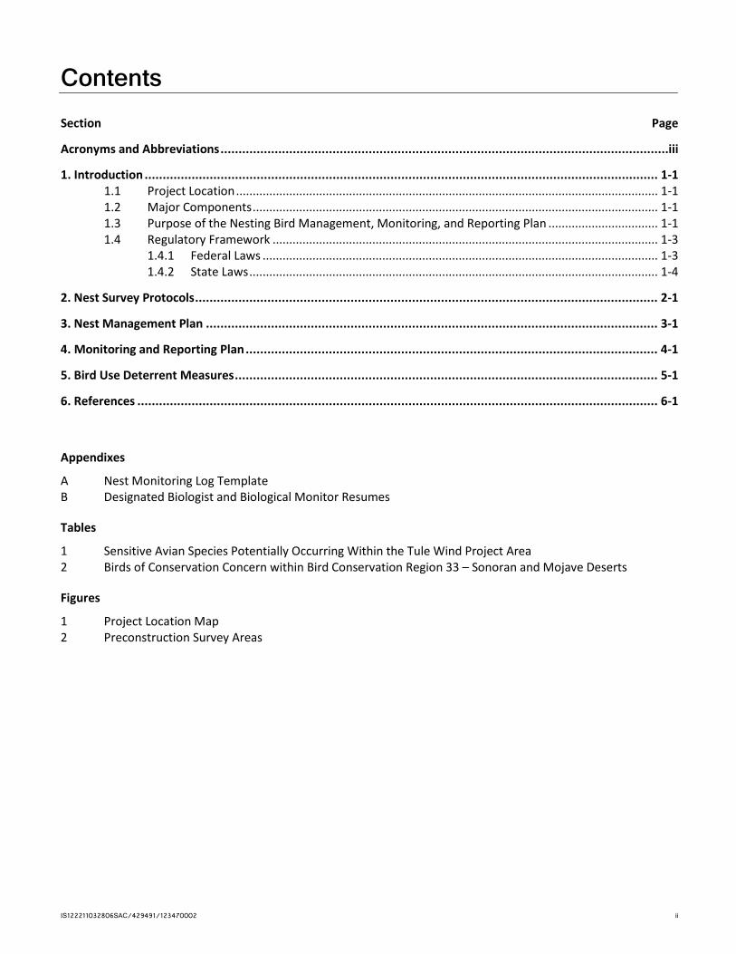
Contents Section Page
Acronyms and Abbreviations ............................................................................................................................ iii
1. Introduction .............................................................................................................................................. 1-1 1.1 Project Location ............................................................................................................................... 1-1 1.2 Major Components .......................................................................................................................... 1-1 1.3 Purpose of the Nesting Bird Management, Monitoring, and Reporting Plan ................................. 1-1 1.4 Regulatory Framework .................................................................................................................... 1-3
1.4.1 Federal Laws ....................................................................................................................... 1-3 1.4.2 State Laws ........................................................................................................................... 1-4
2. Nest Survey Protocols ................................................................................................................................ 2-1
3. Nest Management Plan ............................................................................................................................. 3-1
4. Monitoring and Reporting Plan .................................................................................................................. 4-1
5. Bird Use Deterrent Measures ..................................................................................................................... 5-1
6. References ................................................................................................................................................ 6-1
Appendixes
A Nest Monitoring Log Template B Designated Biologist and Biological Monitor Resumes
Tables
1 Sensitive Avian Species Potentially Occurring Within the Tule Wind Project Area 2 Birds of Conservation Concern within Bird Conservation Region 33 – Sonoran and Mojave Deserts
Figures
1 Project Location Map 2 Preconstruction Survey Areas

IS122211032806SAC/429491/123470002 iii
Acronyms and Abbreviations APLIC Avian Power Line Interaction Committee
BGEPA Bald and Golden Eagle Protection Act
BLM Bureau of Land Management
CDFW California Department of Fish and Wildlife
ESA Federal Endangered Species Act
FEIR/EIS Final Environmental Impact Report/Environmental Impact Statement for the East County Substation, Tule Wind, and Energia Sierra Juarez Gen-Tie Projects
GPS global positioning system
IR Iberdrola Renewables, LLC
kV kilovolt
MBTA Migratory Bird Treaty Act
MM mitigation measure
MSCP Multiple Species Conservation Plan
NBMMRP Nesting Bird Management, Monitoring and Reporting Plan
NML Nest Monitoring Log
O&M operations and maintenance
SDG&E San Diego Gas and Electric
U.S.C. United States Code
USFWS U.S. Fish and Wildlife Service
IS122211032806SAC/429491/123470002 1-1
SECTION 1
Introduction
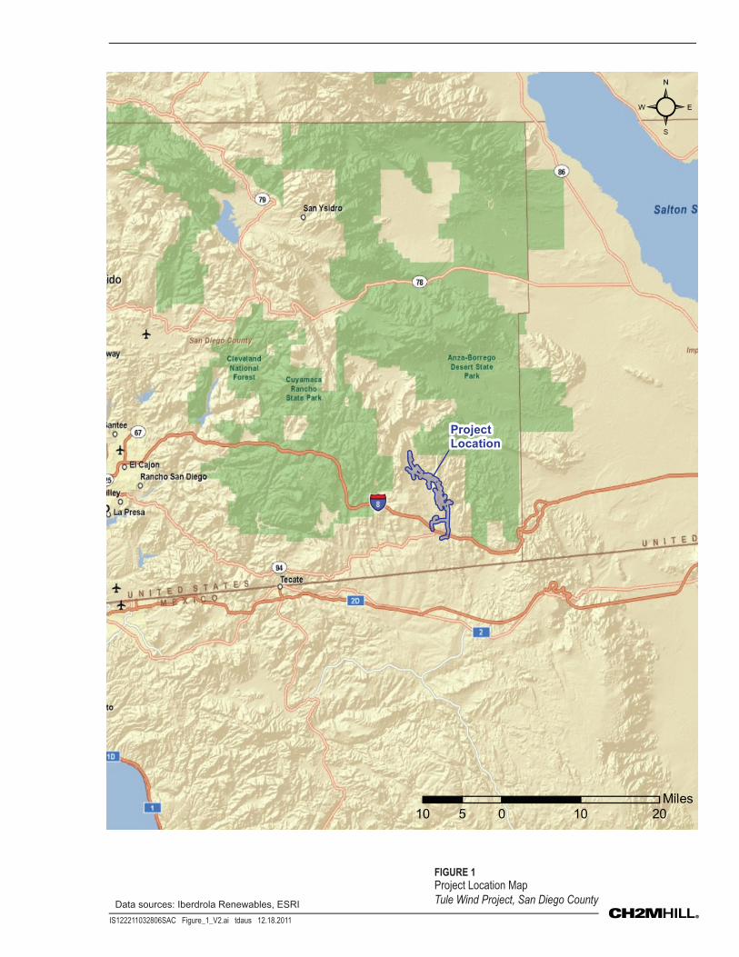
1.1 Project Location Tule Wind LLC, a wholly owned subsidiary of Iberdrola Renewables, LLC (IR), is proposing to construct and operate the Tule Wind Project (Project) located in southeastern San Diego County, near the unincorporated communities of Jacumba and Boulevard, California, approximately 70 miles east of downtown San Diego. The Tule Wind Project will be primarily located in the In-Ko-Pah Mountains near the McCain Valley (Figure 1). The Project will be located on lands administered by the U.S. Bureau of Land Management (BLM) and the California State Lands Commission, as well as private land under the jurisdiction of San Diego County.
1.2 Major Components The Project will consist of the following components:
• 67 wind turbines, each with a generating capacity between 1.5 and 3.0 megawatts, and ranging in height from 219 to 328 feet to the wind turbine hub (or nacelle), and 327 to 492 feet to the top-most blade tip.
• A 34.5-kilovolt (kV) overhead and underground collector cable system linking the wind turbines to the collector substation.
• A 5-acre collector substation site and a 5-acre operations and maintenance (O&M) building site.
• Two permanent meteorological towers and one sonic detecting and ranging (SODAR) unit or one light detecting and ranging (LIDAR) unit.
• A 138-kV overhead transmission line running south from the collector substation to interconnect with the rebuilt San Diego Gas and Electric (SDG&E) Boulevard Substation. The transmission line south of Interstate 8 will be installed below ground.
• 20.76 miles of newly constructed access roads and 12.06 miles of temporarily widened and improved existing access roads.
The Project will connect to the rebuilt Boulevard Substation component of SDG&E’s proposed ECO Substation Project, where the electricity generated would feed into the existing Southwest Powerlink 500-kV transmission line. The Project will result in approximately 334 acres of temporary impacts and 95 acres of permanent impacts.
The Tule Wind Project will employ up to 325 workers per day during the peak construction period with an average daily workforce of 125 workers present at the construction site and up to 200 delivery trucks.
Once completed, up to 12 full-time O&M staff will monitor the Project components from the onsite O&M facility. O&M activities associated with long-term management of the Project will include wind turbine maintenance, and road use and maintenance. All equipment associated with turbine maintenance will stay within the permanent Project footprint.
1.3 Purpose of the Nesting Bird Management, Monitoring, and Reporting Plan
The goal and intent of this report is to support: (1) the construction of a safe and environmentally compliant wind energy project; (2) early identification of potential construction activity conflicts in the construction planning phase; and (3) development and implementation of proper protocols to avoid or minimize potential direct and indirect impacts. As with most ground-disturbing construction activities, impacts to species of concern can be both direct (destroying nests or injuring individuals) and indirect (displacing birds or reducing use of the area).
SECTION 1: INTRODUCTION
IS122211032806SAC/429491/123470002 1-2
Mitigation Measure (MM) BIO-7j of the Final Environmental Impact Report/Environmental Impact Statement for the East County Substation, Tule Wind, and Energia Sierra Juarez Gen-Tie Projects (FEIR/EIS; BLM and CPUC, 2011) and San Diego County Major Use Permit (August 2012) requires that a Nesting Bird Management, Monitoring, and Reporting Plan (NBMMRP) is prepared and submitted to the California Department of Fish and Wildlife (CDFW; formerly California Department of Fish and Game), BLM, U.S. Fish and Wildlife Service (USFWS), and San Diego County for their review and approval if Project construction activities occur during the avian breeding season. Primarily, this NBMMRP is intended to comply with MM-BIO-7j of the FEIR/EIS, which states:
MM-BIO-7j. Preconstruction Nesting Bird Surveys and Avoidance Measures.
Conduct pre-construction nesting bird surveys and implement appropriate avoidance measures for identified nesting birds. If the Project must occur during the avian breeding season (February 1st to August 31st, as early as January 1 for some raptors) the applicant(s) should work with the California Department of Fish and Game (CDFG), Bureau of Land Management, and the U.S. Fish and Wildlife Service (USFWS) to prepare a Nesting Bird Management, Monitoring, and Reporting Plan (NBMMRP) to address avoidance of impacts to nesting birds.
The applicant(s) will submit to the agencies the NBMMRP (see following for details) for review and approval prior to commencement of the Project during the breeding season. The NBMMRP should include the following:
1. Nest Survey Protocols describing the nest survey methodologies
2. A Management Plan describing the methods to be used to avoid nesting birds and their nests, eggs, and chicks
3. A Monitoring and Reporting Plan detailing the information to be collected for incorporation into a regular Nest Monitoring Log (NML) with sufficient details to enable USFSW [sic] and CDFG to monitor the applicant’s compliance with Fish and Game Code Sections 3503, 3503.5, 3511, and 3513
4. A schedule for the submittal (usually weekly) of the NML
5. Standard buffer widths deemed adequate to avoid or minimize significant Project-related edge effects (disturbance) on nesting birds and their nests, eggs, and chicks
6. A detailed explanation of how the buffer widths were determined
7. All measures the applicant will implement to preclude birds from utilizing Project-related structures (i.e., construction equipment, facilities, or materials) for nesting
To determine presence of nesting birds that the Project activities may affect, surveys should be conducted beyond the Project area—300 feet for passerine birds and 500 feet for raptors. The survey protocols should include a detailed description of methodologies utilized by CDFG-approved avian biologists to search for nests and describe avian behaviors that indicate active nests. The protocols should include but are not limited to the size of Project corridor being surveyed, method of search, behavior that indicates active nests.
Each nest identified in the Project area should be included in the NML. The NMLs should be updated daily and submitted to the CDFG weekly. Since the purpose of the NMLs is to allow the CDFG to track compliance, the NMLs should include information necessary to allow comparison between nests protected by standard buffer widths recommended for the Project (300 feet for passerine birds, 500 feet for raptors) and nests whose standard buffer width was reduced by encroachment of Project-related activities. The NMLs should provide a summary of each nest identified, including the species, status of the nest, buffer information, and fledge or failure data. The NMLs will allow for tracking the success and failure of the buffers and will provide data on the adequacy of the buffers for certain species.
SECTION 1: INTRODUCTION
IS122211032806SAC/429491/123470002 1-3
The applicant(s) will rely on its avian biologists to determine the appropriate standard buffer widths for nests within the Project corridor/footprint to employ based on the sensitivity levels of specific species or guilds of avian species. The determination of the standard buffer widths should be site- and species-/guild-specific and data-driven and not based on generalized assumptions regarding all nesting birds. The determination of the buffer widths should consider the following factors:
a. Nesting chronologies
b. Geographic location
c. Existing ambient conditions (human activity within line of sight—cars, bikes, pedestrians, dogs, noise)
d. Type and extent of disturbance (e.g., noise levels and quality—punctuated, continual, ground vibrations—blasting-related vibrations proximate to tern colonies are known to make the birds flush the nests
e. Visibility of disturbance
f. Duration and timing of disturbance
g. Influence of other environmental factors
h. Species’ site-specific level of habituation to the disturbance
Application of the standard buffer widths should avoid the potential for Project-related nest abandonment and failure of fledging, and minimize any disturbance to the nesting behavior. If Project activities cause or contribute to a bird being flushed from a nest, the buffer must be widened.
1.4 Regulatory Framework Several laws and regulations have been enacted in the United States and in California that provide protections for avian species; these are described in the following sections. IR has consulted with USFWS and CDFW to address species that might be present at the Project site that are afforded protection under these laws.
1.4.1 Federal Laws 1.4.1.1 Migratory Bird Treaty Act Under the Migratory Bird Treaty Act (MBTA) (16 United States Code [U.S.C.] §§ 703-712) it is “unlawful to pursue, hunt, take, capture or kill; attempt to take, capture or kill; possess, offer to or sell, barter, purchase, deliver or cause to be shipped, exported, imported, transported, carried or received any migratory bird, part, nest, egg or product...” The MBTA does not have provisions for authorizing “take” of migratory birds that may be killed or injured by otherwise lawful activities.
1.4.1.2 Bald and Golden Eagle Protection Act Bald eagles (Haliaeetus leucocephalus) and golden eagles (Aquila chrysaetos) are protected under the MBTA and Bald and Golden Eagle Protection Act (BGEPA) (16 U.S.C. §§ 668-668c). BGEPA affords eagles additional protection from take, as well as protection from disturbance. To “disturb” an eagle means: “to agitate or bother a bald or golden eagle to a degree that causes, or is likely to cause, based on the best scientific information available, 1) injury to an eagle, 2) a decrease in its productivity, by substantially interfering with normal breeding, feeding, or sheltering behavior, or 3) nest abandonment, by substantially interfering with normal breeding, feeding, or sheltering behavior.” No avian species protected under the federal Endangered Species Act (ESA; 16 U.S.C. § 1531 et seq.) are expected to occur in the Project area or be at risk of impact from the Project.
SECTION 1: INTRODUCTION
IS122211032806SAC/429491/123470002 1-4
1.4.1.3 Endangered Species Act No avian species protected under the federal ESA (16 U.S.C. § 1531 et seq.) are expected to occur in the Project area or be at risk of impact from the Project; therefore the ESA is not discussed.
1.4.2 State Laws The California Environmental Quality Act and Fish and Game Code wildlife protection laws require that government agencies develop standards and procedures necessary to maintain, protect, restore, and enhance environmental quality, including fish and wildlife populations and plant and animal communities, and to ensure that projects comply with these laws. California Fish and Game Code sections that relate to protection of avian and wildlife resources and are relevant to wind energy projects are listed below:
• California Endangered Species Act, 1984—Fish and Game Code section 2050–2069 • Bird Nests or Eggs, Fish and Game Code 3503 • Birds of Prey and Their Eggs, Fish and Game Code section 3503.5 • Fully Protected Species, Fish and Game Code sections 3511 • Migratory Birds, Fish and Game Code section 3513
²
10 0 10 205
Miles
Project
Location
IS122211032806SAC Figure_1_V2.ai tdaus 12.18.2011
FIGURE 1
Project Location Map
Tule Wind Project, San Diego CountyData sources: Iberdrola Renewables, ESRI
IS122211032806SAC/429491/123470002 2-1
SECTION 2
Nest Survey Protocols Sensitive avian species and their respective habitat potentially occurring within the Project area are described in Table 1, and birds with conservation concern in Bird Conservation Region 33 (Sonoran and Mojave Deserts) are listed in Table 2 as reported in the Avian and Bat Protection Plan developed for the Project (Tule Wind LLC, 2011). Surveys will be completed to locate any nesting bird species present within areas proposed for construction, and within the prescribed survey buffer, to ensure that avoidance measures are implemented to eliminate risk of construction-related impacts.
Surveys to detect nests are based on the mitigation measures described in the FEIR/EIS (MM-BIO-7j) (BLM and CPUC, 2011). Nest surveys will be conducted by visually inspecting all ground, shrubs, trees, cliffs, rock outcrops and manmade structures suitable for nesting within 300 feet of construction corridors for passerines and within 500 feet for raptors (Figure 2). This survey area will be inspected by qualified biologists using visually overlapping pedestrian transects, spaced approximately 30 to 100 feet apart based on existing topography, conditions, and vegetation to identify nesting birds and their nests.
Surveys will be conducted within 2 weeks of the start of construction scheduled to occur during the avian nesting season (February 1 to August 31 for passerines, January 1 to August 31 for raptors). Surveys will be within the prescribed survey areas of 300 and 500 feet for passerines and raptors respectively, from all areas proposed for ground disturbance. All nests discovered during these surveys will be logged on a Nest Monitoring Log (NML) and updated per the Project’s Nest Management Plan described in Section 3. The NML will include a summary of each nest identified, including the species, status of the nest, buffer information, and fledge or failure data (a sample NML is provided in Appendix A). For all nests discovered, a qualified biologist will determine if construction activities could potentially disturb nesting birds and will implement appropriate impact avoidance measures (for example, onsite monitoring, setbacks, timing restrictions) to adequately protect nesting birds as described in the Nest Management Plan. Nest status will be designated as follows:
• Active – Adults exhibiting courtship, nest building, incubating, or chick-rearing behavior are observed and/or eggs or nestling/fledgling chicks are observed.
• Inactive – no sign of activity as described for active nests
• Undetermined – status cannot be determined for any reason (for example, conditions unsafe to assess, view into nest not available, length of time nest observed insufficient to document status). Undetermined nests will be monitored as active until otherwise determined inactive.
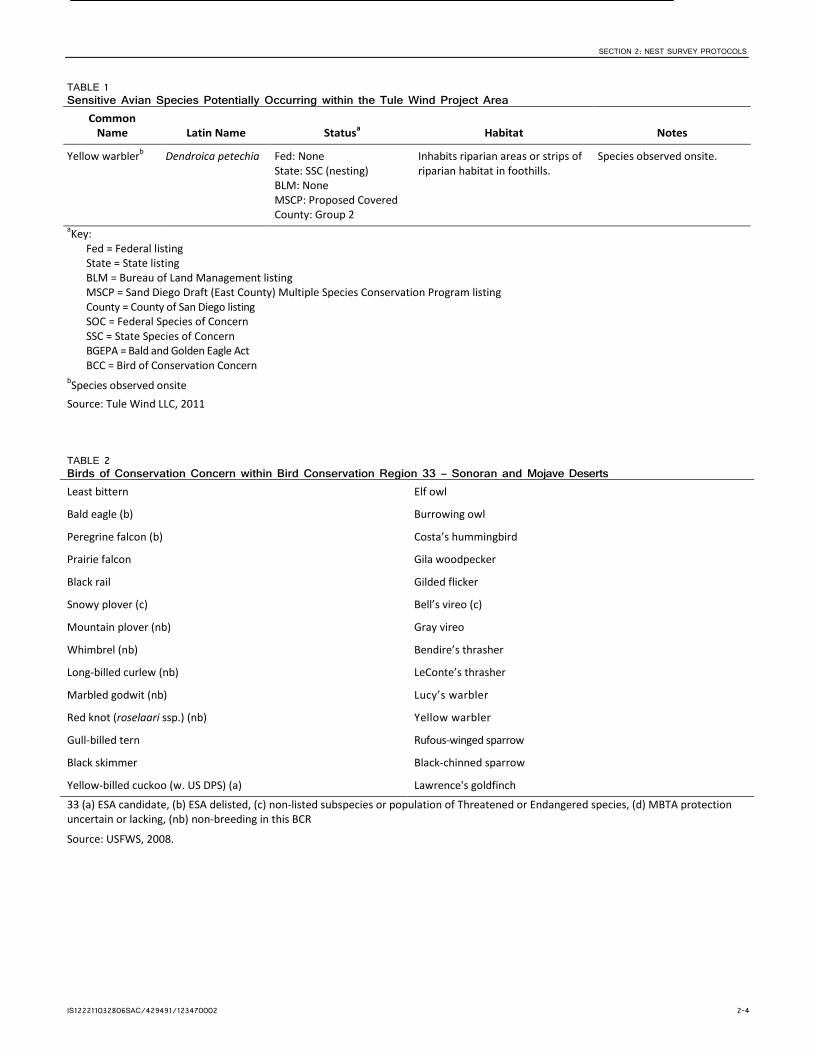
TABLE 1 Sensitive Avian Species Potentially Occurring within the Tule Wind Project Area
Common Name Latin Name Statusa Habitat Notes
Bell’s sage sparrow
Amphispiza belli belli
Fed: None State: None BLM: None MSCP: None County: Group 1
Common resident in semiarid scrub and sometimes in chamise chaparral.
Species not observed onsite, but suitable habitat found onsite.
Cooper’s hawkb Accipiter cooperii Fed: None State: None BLM: None MSCP: None County: Group 1
Common resident in trees, especially pines, hardwood groves and riparian cottonwoods and sycamores.
Species observed onsite.

SECTION 2: NEST SURVEY PROTOCOLS
IS122211032806SAC/429491/123470002 2-2
TABLE 1 Sensitive Avian Species Potentially Occurring within the Tule Wind Project Area
Common Name Latin Name Statusa Habitat Notes
Golden eagleb Aquila chrysaetos Fed: BGEPA State: Fully Protected BLM: Sensitive MSCP: Proposed Covered County: Group 1
Found in open coniferous forest and barren areas, especially in hilly or mountainous regions.
Species observed onsite.
Gray vireo Vireo vicinior Fed: BCC State: SSC BLM: Sensitive MSCP: Proposed Covered County: Group 1
Inhabits desert scrub, mixed juniper or pinyon pine and oak scrub, and chaparral in hot, arid mountains and high scrubland.
Species not observed. Has potential to occur onsite during migration.
Least Bell’s vireo Vireo bellii pusillus Fed: Endangered State: Endangered BLM: None MSCP: Proposed Covered County: Group 1
Found in willow dominated riparian habitat.
Species not observed onsite. No habitat found onsite.
Loggerhead shrikeb
Lanius ludovicianus Fed: None State: SSC BLM: None MSCP: Proposed Covered County: Group 1
Inhabits open brushy areas, meadows, pastures, orchards, thickets along roads, and hedges.
Species observed onsite.
Long-eared owlb Asio otus Fed: None State: SSC BLM: None MSCP: Proposed Covered County: Group 1
Inhabits dense vegetation adjacent to open grassland or shrub-land, and open forests.
Incidental observation in winter 2007.
Northern harrierb Circus cyaneus Fed: None State: SSC BLM: None MSCP: Covered County: Group 1
Found in abandoned fields, upland maritime heaths, wet hayfields, salt marshes, and cattail marshes.
Species observed onsite.
Olive-sided flycatcherb
Contopus cooperi Fed: None State: SSC BLM: None MSCP: None County: Group 2
Found on edges, openings, and natural and human-created clearings adjacent to otherwise relatively dense forests.
Species observed onsite.
Prairie falconb Falco mexicanus Fed: BCC State: None BLM: None MSCP: None County: Group 1
Often found where there are large patches of low vegetation and areas of open ground, vertical cliffs with a rock overhang are preferred for nesting.
Species observed onsite.
Purple martin Progne subis Fed: None State: SSC (nesting) BLM: None MSCP: Proposed Covered County: Group 1
Breeds near human settlements where nest houses are provided, especially near water and large open areas.
Species not observed onsite. Has the potential to occur onsite.
Rufous-crowned sparrowb
Aimophila ruficeps Fed: None State: None BLM: None MSCP: Proposed Covered County: Group 1
Found in coastal sage scrub and other low growing scrublands.
Species observed onsite.

SECTION 2: NEST SURVEY PROTOCOLS
IS122211032806SAC/429491/123470002 2-3
TABLE 1 Sensitive Avian Species Potentially Occurring within the Tule Wind Project Area
Common Name Latin Name Statusa Habitat Notes
Southwestern willow flycatcher
Empidonax traillii extimus
Fed: Endangered State: Endangered BLM: None MSCP: Proposed Covered County: Group 1
Inhabits dense trees or thickets near water.
Species not observed onsite. No habitat for this species is found onsite.
Species observed offsite incidentally.
Tricolored blackbird
Agelaius tricolor Fed: None State: SSC BLM: Sensitive MSCP: Covered County: Group 1
Found in cropland, hedgerows, grassland and herbaceous areas.
Species not observed. Has a low potential to occur onsite while foraging.
Turkey vultureb Cathartes aura meridionalis
Fed: None State: None BLM: None MSCP: Proposed Covered County: Group 1
Found in dry, open country, farmlands, and woodlands. Needs tall trees for roosting.
Species observed onsite.
Vaux’s swiftb Chaetura vauxi Fed: None State: SSC BLM: None MSCP: None County: None
Found in mature forest but will also forage and migrate over open country.
Species observed onsite.
Vermilion flycatcher
Pyrocephalus rubinus flammeus
Fed: None State: SSC BLM: None MSCP: None County: Group 1
Arid scrub, farmlands, savanna, agricultural areas, and riparian woodland.
Species not observed. Has low potential to occur onsite.
Western bluebirdb Silalia mexicana Fed: None State: None BLM: None MSCP: None County: Group 2
Woodlands, farmlands, orchards, savanna, riparian woodlands, and burned or disturbed woodlands.
Species observed onsite.
Western burrowing owl
Athene cunicularia hypugaea
Fed: None State: SSC BLM: Sensitive MSCP: Proposed Covered County: Group 1
Nesting habitat consists of open areas with mammal burrows in arid and semi-arid environments.
Species not observed onsite. Has a low potential to occur onsite.
White-tailed kiteb Elanus leucurus Fed: None State: Fully Protected BLM: None MSCP: Proposed Covered County: Group 1
Riparian woodland, oak groves, or sycamore groves adjacent to grassland.
Incidental observation during 2005–2006 avian survey.
Willow flycatcher Empidonax traillii Fed: None State: Endangered BLM: None MSCP: None County: None
Breeds in shrubby areas near running or standing water and winters in shrubby clearings with successional growth.
Species not observed onsite. No habitat is found onsite; however, two offsite observations in Thing Valley were recorded during the 2007–2008 avian survey.
SECTION 2: NEST SURVEY PROTOCOLS
IS122211032806SAC/429491/123470002 2-4
TABLE 1 Sensitive Avian Species Potentially Occurring within the Tule Wind Project Area
Common Name Latin Name Statusa Habitat Notes
Yellow warblerb Dendroica petechia Fed: None State: SSC (nesting) BLM: None MSCP: Proposed Covered County: Group 2
Inhabits riparian areas or strips of riparian habitat in foothills.
Species observed onsite.
aKey: Fed = Federal listing State = State listing BLM = Bureau of Land Management listing MSCP = Sand Diego Draft (East County) Multiple Species Conservation Program listing County = County of San Diego listing SOC = Federal Species of Concern SSC = State Species of Concern BGEPA = Bald and Golden Eagle Act BCC = Bird of Conservation Concern
bSpecies observed onsite Source: Tule Wind LLC, 2011
TABLE 2 Birds of Conservation Concern within Bird Conservation Region 33 – Sonoran and Mojave Deserts Least bittern Elf owl
Bald eagle (b) Burrowing owl
Peregrine falcon (b) Costa’s hummingbird
Prairie falcon Gila woodpecker
Black rail Gilded flicker
Snowy plover (c) Bell’s vireo (c)
Mountain plover (nb) Gray vireo
Whimbrel (nb) Bendire’s thrasher
Long-billed curlew (nb) LeConte’s thrasher
Marbled godwit (nb) Lucy’s warbler
Red knot (roselaari ssp.) (nb) Yellow warbler
Gull-billed tern Rufous-winged sparrow
Black skimmer Black-chinned sparrow
Yellow-billed cuckoo (w. US DPS) (a) Lawrence's goldfinch
33 (a) ESA candidate, (b) ESA delisted, (c) non-listed subspecies or population of Threatened or Endangered species, (d) MBTA protection uncertain or lacking, (nb) non-breeding in this BCR
Source: USFWS, 2008.

Source: HDR
#
#
#
#
!(
!(
!(
!(
!(
!(
!(
!(
!(
!(
!(
!( !(
!(
!(
!(
!(
!(
!(
!(
!(
!(
!(
!(
!(
!(
!(
!(
!(
!(
!(
!(
!(
!(!(
!(
!(
!(
!(
!(
!(
!(
!(
!(
!(
!(
!(
!(
!(
!(
!(
!(!(
!(
!(
!(
!(
!(
!(
!(
!(
!(
!(
!(
!(
!(
!(
!(
RED SHANK LN
OLD HIGHWAY 80
HI PASS RD
TIE
RR
A D
EL
SO
L R
D
AN
GE
L D
R
LI
L
L IE LN
CAM TRES AVES
LIL
AC
TL
BLACKW
OO
D RD
STARSH
IP S
T
WORTHINGTON RD
SH
AS
TA
TL
BLACKWOO D RD
CHURCH RD
E NC
INA
VE
RD
E
QU
AIL
RU
N
MI L
LER
VA
LLE
Y R
D
H ON
EY
BEE
LN
GREAT BLUE HERON WY
LILAC LN
RO SS
AV
JEWEL VALLEY WY
MIL
LE
R
VALL
EY
R D
MANZAN
ITA DUL
CE
CROSS RD
SOL WOOD
HUBBLE RD
OLD
MI N
E R
D
SHASTA WY
FL YIN
G
CL OU
D P
L
CANE
BRAK
E RD
JEW
EL
VA
LLE
Y R
D
WIL
LIA
MS
RD
STAG
ECOA CH S PRIN
GS
RD
LIV
E O
AK
SP
RINGS
RD
LOST VA LLEY
RD
PINION PINE TL
GR
EA
T E
AG
L E WY
THIN
G V
ALLE
Y R
D
WIL
LIA
MS
RD
CR
ES
TW
OO
D /
BIA
12
RIB
BO
NW
OO
D R
D
MC
CA
IN V
ALL
EY
RD
CR
ESTW
OO
D R
D
MC
CA
IN V
ALLE
Y R
D
MA
NZ
AN
IT
A C
OT
TO
NW
OO
D R
D
StateStateof Californiaof California
LandsLandsCommissionCommission
BLMBLMLandLand
BLM LandBLM Land
IndianIndianReservationReservation
Campo IndianCampo IndianReservationReservation
CampoCampoIndianIndian
ReservationReservation
CampoCampoIndianIndian
ReservationReservation
EwiiaapaaypEwiiaapaaypIndianIndian
ReservationReservation
State ofState ofCaliforniaCalifornia
(Conservation)(Conservation)
BLM LandBLM Land
BLM LandBLM Land
La PostaLa PostaIndianIndian
ReservationReservation
ManzanitaManzanitaIndianIndian
ReservationReservation
AB94
§̈¦8
&,W
&,W
&,W
ConstructionWell 6&6a
ConstructionWell 8
Thing ValleyNorth Well
ProposedTransmission
Line
PM-E-2
PM-W-2
PM-E-1
PM-W-1
A-2
A-4
A-5
A-3
A-7
G-13
A-6
A-1
D-3
B-6
B-5
E-4 E-5
E-10
E-11
F-2
G-2
G-3
G-14
R-10
G-8
B-3
D-9
E-7
G-11
G-12
G-15
T-1
E-8
D-8
G-9
F-3
G-5
E-2E-1
G-6
D-5
D-2
C-2
C-3
E-12
F-4
D-10
E-3
B-4
G-7
G-16
S-1
R-11
R-7
E-6
G-10
T-2
R-8
R-9
E-9
F-1
G-4
D-7
G-1
D-6
C-4
D-1
D-4
C-1
B-7
B-2
B-1
RebuiltBoulevardSubstation
L
L
L
L
L
L
L
L
L
L
L
L
B
P
/ 0 1 20.5
Miles
Turbines and Met Towers Phase 1
!( Proposed Turbine Location
# Proposed Met Station
# Alternate Met Station
Project Collector System Phase 1
Proposed Overhead Collector
Proposed Underground Collector
Project Transmission Line Phase 1
Proposed Transmission Line
O & M Building and Substation Phase 1
Proposed Substation
Proposed O&M Building
Access Roads Phase 1
Proposed New Roads
Existing Roads to be Improved
Temporary Construction Areas Phase 1
Proposed 10-acre Parking Area
Proposed 2-acre Laydown Area
Proposed Batch Plant
Ownership
BLM Land
Indian Reservation
State of California (Conservation)
State of California Lands Commission
&,W Construction Well
Rebuilt Boulevard Substation
P
L
B
IS122211032806SAC Figure_2.ai tdaus 01.03.2012
FIGURE 2Proposed Project LayoutTule Wind Project, San Diego County
IS122211032806SAC/429491/123470002 3-1
SECTION 3
Nest Management Plan If active or undetermined status nests are detected during the preconstruction survey, a no-disturbance buffer zone will be established and a site-specific nest monitoring plan will be implemented. The size of the buffer area will be determined by the Designated Biologist in accordance with the proposed nesting buffer widths will be in accordance with mitigation measure MM-BIO-7j. Preconstruction nesting bird surveys and avoidance measures will be 1 mile for a golden eagle nest and up to 500 feet for other avian species. The Designated Biologist will make the final determination in the field for exclusion zone. Designated Biologist resumes are presented in Appendix B.
Standard nest buffers will be applied to each active or undetermined-status nest; however, the Designated Biologist may expand or reduce this limit based on factors such as: nesting chronology of the species, existing ambient conditions (human activity within line of sight—cars, bikes, pedestrians, dogs, noise), type and extent of disturbance (noise levels and quality—punctuated, continual, ground vibrations—blasting-related vibrations), visibility of disturbance, duration and timing of disturbance, influence of other environmental factors, and the species’ site-specific level of habituation to the disturbance. An NML will be completed for each active nest, and a map or aerial photograph identifying the location of the nest and the boundaries of the no-disturbance buffer zone around the nest will be generated.
Active/undetermined-status nests will be monitored at approximately 7-day intervals and logged in the NML until such time that the Designated Biologist determines that the nestlings have fledged and dispersed or that the nest is otherwise no longer active. Nests detected in areas causing significant delays to construction may be monitored at shorter intervals to potentially expedite construction in those areas. Bird nest locations will be mapped using a global positioning system (GPS) unit and will be recorded in the NML and submitted weekly to CDFW, or plotted on U.S. Geological Survey topographic maps to avoid disturbing nesting birds. Activities that might, in the opinion of the Designated Biologist, disturb nesting activities will be prohibited within the buffer zone until such a determination is made. A biological monitor will be present at the construction site during all construction activities.
Any nests found in or adjacent to disturbance areas will be flagged and the area around the nest will protected by an exclusion zone from construction equipment and disturbance, per the appropriate nesting buffer width for the species, with high visibility flagging tape to demarcate sensitive habitat. No work activities will be conducted within the designated exclusion zones as identified by the Designated Biologist. Application of the appropriate buffer width should minimize any disturbance to the nesting behavior and avoid the potential for Project-related nest abandonment and failure of fledging. Each exclusion zone will be maintained until construction activities have been completed, or until nesting is complete, and would then be removed.
If Project activities cause or contribute to a bird being flushed from the nest, the buffer will be widened and actions taken will be documented in the NML. Likewise, if activities cause nest failures, the standard buffer width for that species may be increased.

IS122211032806SAC/429491/123470002 4-1
SECTION 4
Monitoring and Reporting Plan All nests discovered will be documented in the NMLs and monitored from an appropriate distance with binoculars, at intervals no longer than 7 days apart, until the Designated Biologist has determined that the nest has failed or fledged. Each nest will be located using GPS, given a unique identification number for tracking purposes, and any action taken to protect the nest will be described, including but not limited to creating an exclusion zone. NMLs will be updated at each monitoring event to reflect the current status of the nest and any comments, observations, or actions taken. The NMLs will serve as documentation of the Project’s compliance with Fish and Game code sections 3503, 3503.5, 3511, and 3513 and will be submitted to CDFW per Mitigation Measure BIO 7j on a monthly basis. Nest failures that occur will be reported in the NMLs and provided in the monthly reports. Nest failures that appear to be the direct result of the construction activity will be reported within 48 hours of discovery, via phone call and/or email to the appropriate agency contacts.
Jessie Bennett OR Thomas Dietsch U.S. Fish and Wildlife Service Carlsbad Fish and Wildlife Office 6010 Hidden Valley Road, Suite 101 Carlsbad, California 92011 Email: Telephone:
Erin Wilson California Dept. of Fish and Wildlife 3883 Ruffin Road San Diego, CA 92123 Email: Telephone:
Kim Marsden Bureau of Land Management California Desert District Renewable Energy Coordinating Office 22835 Calle San Juan de los Lagos Moreno Valley, CA 92553 Email: Telephone:
IS122211032806SAC/429491/123470002 5-1
SECTION 5
Bird Use Deterrent Measures Construction activities during the nesting season (January 1 through August) could adversely affect breeding birds through direct take or indirectly through disruption or harassment. Key avoidance and minimization measures to deter birds from using the site or Project structures include construction of the transmission line following Avian Power Line Interaction Committee (APLIC) guidelines (APLIC, 2006), collection line burial, where feasible, lighting minimization, ground-disturbance restrictions, a full-time biological monitor onsite during construction activities, and standard industry low-impact turbine and meteorological tower design. The Tule Wind Project will implement IR’s Avian and Bat Protection Plan (IR, 2008) as a means to reduce impacts to nesting birds, and will also adhere to the following design plans and mitigation measures to minimize use of Project structures by nesting birds and raptors:
Free-standing Meteorological Tower. Permanent meteorological towers will be free-standing (unguyed) structures; thereby minimizing the risk for bird collisions.
MM-BIO-10a. Follow APLIC Guidelines. Design all transmission towers and lines to conform to APLIC standards. The Project will implement recommendations by the APLIC (2006), which will protect raptors and other birds from electrocution. These measures are sufficient to protect even the largest birds that may perch or roost on transmission lines or towers from electrocution.
MM-BIO-10d. Minimize Turbine Lighting. Night-lighting may serve as an attractant for birds, especially migrants, which may be attracted to the light and then become unable to leave it. Except for Federal Aviation Administration-required lighting, wind turbines will avoid any lighting that attracts birds.
BIO-7a. Minimize the Use of Aboveground Lines. Tule Wind LLC will implement the proposed facility design to minimize the use of aboveground lines, where feasible. Underground collector lines will be used to the maximum extent feasible.
BIO-7c. Tower Design to Deter Perching. The tubular design of the towers may help deter raptors and other birds from perching and nesting on the structures and minimize direct impacts from collision with wind turbines.

IS122211032806SAC/429491/123470002 6-1
SECTION 6
References Avian Power Line Interaction Committee (APLIC). 2006. Suggested Practices for Avian Protection on Power Lines, the State of the Art in 2006. Edison Electric Institute, Washington, D.C.
California Energy Commission (CEC) and California Department of Fish and Game (CDFG). 2007. California guidelines for reducing impacts to birds and bats from wind energy development. Report No. CEC-700-2007-008-CMF.
California Public Utilities Commission (CPUC) and Bureau of Land Management (BLM). 2010. Draft Environmental Impact Report/Environmental Impact Statement.
Iberdrola Renewables, Inc. (IRI). 2008. Avian and Bat Protection Plan (ABPP). Version 1 dated October 10, 2008. Final Approved Document, Portland, Oregon. Available online at: http://www.iberdrolarenewables.us/pdf/Signed_ABPP_10-28-08.pdf.
Tule Wind LLC. 2011. Project-specific Avian and Bat Protection Plan for the Tule Wind Project. September 30, 2011.
United States Department of the Interior, Bureau of Land Management (BLM) and California Public Utilities Commission (CPUC). 2011. Final Environmental Impact Report/Environmental Impact Statement for East County Substation, Tule Wind, and Energia Sierra Juarez Gen-Tie Projects. Prepared by Dudek. October.
United States Fish and Wildlife Service (USFWS). 2008. Birds of Conservation Concern 2008. United States Department of Interior, Fish and Wildlife Service, Division of Migratory Bird Management, Arlington, Virginia. 85 pp. Available online at: http://www.fws.gov/migratorybirds/
Appendix A Nesting Monitoring Log Template
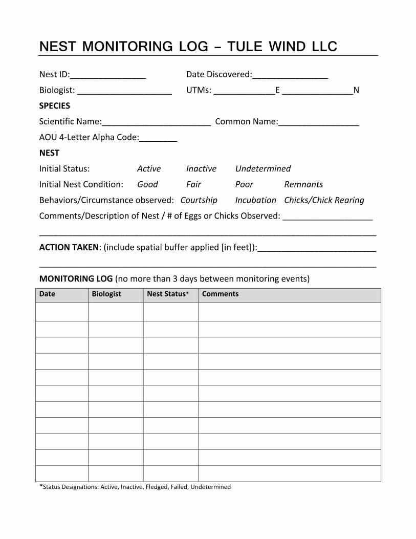
NEST MONITORING LOG – TULE WIND LLC
Nest ID:________________ Date Discovered:________________
Biologist: ____________________ UTMs: _____________E _______________N
SPECIES
Scientific Name:_______________________ Common Name:_________________
AOU 4-Letter Alpha Code:________
NEST
Initial Status: Active Inactive Undetermined
Initial Nest Condition: Good Fair Poor Remnants
Behaviors/Circumstance observed: Courtship Incubation Chicks/Chick Rearing
Comments/Description of Nest / # of Eggs or Chicks Observed: ___________________
_______________________________________________________________________
ACTION TAKEN: (include spatial buffer applied [in feet]):_________________________
_______________________________________________________________________
MONITORING LOG (no more than 3 days between monitoring events) Date Biologist Nest Status* Comments
*Status Designations: Active, Inactive, Fledged, Failed, Undetermined

Appendix B Designated Biologist and
Biological Monitor Resumes
ASHLEY R. RICHMOND
EDUCATION Master of Science in Zoology Miami University, Department of Zoology, Oxford, Ohio Thesis: The effects of avpr1a microsatellite length and population density on indices of social and genetic monogamy in male
prairie voles (Microtus ochrogaster) Bachelor of Science in both Zoology and Environmental Science Miami University, Oxford, Ohio Research capstone: A spatial analysis of home range overlap in wandering male prairie voles (Microtus ochrogaster)
PROFESSIONAL EXPERIENCE Biologist (May 2011 - Current) CH2M Hill, San Diego, California Conducts monitoring, surveying, and enforces measures to protect federally and state listed Bakersfield cacti (Opuntia basilaris
var. treleasei) and desert tortoise (Gopherus agassizii) pursuant to Incidental Take Permit No. 2081-2011-009-04 for Alta Wind VI, LLC and Alta Wind VIII, LLC, Kern County, California
Coordinates daily with construction foreman, construction superintendents, subcontractors, and the owners’ representatives to ensure construction tasks are supervised by biological monitors, establishes Plan of the Day for biological workers
Trains all new workers arriving onsite to adhere to mitigation measures, regulations, and guidelines set forth in the Worker Environmental Awareness Program (WEAP), provides follow-up discussion and reminders at weekly all-hands meetings, completes compliance management and reporting
Performs pre-construction rare plant surveys, including Bakersfield cacti and Joshua tree (Yucca brevifolia) data collection, initial habitat characterization, and Swainson’s hawk surveys for proposed wind energy development
Assists with live-trapping surveys for Mohave ground squirrels (Xerospermophilus mohavensis) in Kern County Biologist (June 2007 – April 2011) BHE Environmental, Inc., Cincinnati, Ohio Key personnel for regional Habitat Conservation Plan addressing whooping cranes (Grus americana) and lesser prairie-chickens
(Tympanuchus pallidicinctus), participates in report preparation, presents findings and recommendations to Federal and State agencies, conducts spatial analysis of HCP covered activities build-out during life of permit and endangered species occurrence
Supports NEPA compliance documentation for clients such as Department of Defense, State Departments of Transportation, Federal Highway Administration, and U.S. Fish and Wildlife Service (for wind energy permitting)
Prepared materials for Ohio Power Siting Board (OPSB) application and provided support for ecological studies (habitat, wetlands, bird and bat risk assessment, cultural resources) for wind energy facility in Hardin County, Ohio
Prepared exhibits to accompany testimony during federal litigation regarding potential presence of endangered bat species at a proposed wind facility in West Virginia
Created sampling tracts for post-construction bat and bird mortality monitoring on Fond du Lac County, Wisconsin wind energy facility
Assisted in mist-net and radiotelemetry survey of the Indiana bat (Myotis sodalis) on a proposed natural gas pipeline right-of-way spanning four states
Performed nest box surveys of West Virginia northern flying squirrel (Glaucomys sabrinus fuscus) in support of Habitat Conservation Plans under Section 10 of the Endangered Species Act in Pocahontas County, West Virginia
Graduate Assistant (August 2005 – May 2007) Miami University, Department of Zoology Taught introductory physiology laboratory and animal behavior (senior capstone laboratory course) Conducted and coordinated all field efforts, recruited and collaborated with 10 undergraduate field assistants assessing mating and
social habits of prairie voles Examined spatial use of prairie voles using mark/recapture live-trapping and radiotelemetry, analyzed home ranges in GIS
environment Coordinated and performed DNA fragment analysis for 500+ specimen and quantitative real-time RT-PCR on mRNA
402 W. Broadway
Suite 1450 San Diego, California 92101

Field Assistant (October 2003 – August 2005) Miami University, Department of Zoology and Ecology Research Center Live-trapped prairie voles and built GIS database of spatial locations as part of mark/recapture study Used ultraviolet powder tracking and radiotelemetry to monitor nest locations Performed predator chase studies as part of larger study on maternal investment in prairie voles Maintained laboratory breeding colonies of prairie voles and pine voles (Microtus pinetorum) and performed husbandry duties
AWARDS AND GRANTS Innovation Award (nominee), BHE Environmental, Inc. (2010) Innovation Award, BHE Environmental, Inc. (2009) Rookie of the Year, BHE Environmental, Inc. (2008) Society for Integrative and Comparative Biology Grants-in-Aid of Research (2006) T. K. Wilson and W. Hardy Eshbaugh Botany Scholarship (2006) Sigma Xi Grants-in-Aid of Research (2005) Gary Barrett Award for Most Outstanding Undergraduate Research in Ecology (2005) Miami University Undergraduate Research Grant (2004)
TRAINING, CERTIFICATIONS, AND PERMITS Desert Tortoise Council Surveying, Monitoring, and Handling Workshop (2011) Field Assistant on Mohave ground squirrel Memorandum of Understanding (B. Vanherweg 2011) OSHA 10-Hour Training, current certification National Safety Council’s Standard First Aid, CPR, and AED (II), current certification Heartsaver First Aid and CPR Certified, American Heart Association (2008-2011) Wildlife Animal Permit (Bats) #11-84, Ohio Dept. of Natural Resources (2008-2011) Wildlife Animal Permit (Fish and Aquatic Invertebrates) #11-136, Ohio Dept. of Natural Resources (2008-2011) Scientific Wildlife Collecting Permit #SC0811091, Kentucky Dept. of Fish and Wildlife Resources (2008) T&L Contractor Safety, Marathon Petroleum Company (2008) Vertical Cave Rappelling, Lost Creek Packs (2007) Lead Facilitator / Climbing Instructor, Experiential Systems, Inc. (2003)
PUBLICATIONS Solomon, N., A. Richmond, P. Harding, A. Fries, S. Jacquemin, R. Schaefer, K. Lucia and B. Keane. 2009. Polymorphism
at the avpr1a locus in male prairie voles correlated with genetic but not social monogamy in field populations. Molecular Ecology 18:4680-4695.
Keane, B., L. Bryant, U. Goyal, S. Williams, S.L. Kortering, K.E. Lucia, A.R. Richmond and N.G. Solomon. 2007. Effect of
body condition at weaning on survival and reproduction in prairie voles. Canadian Journal of Zoology 85:718-727. Richmond, A.R. 2007. The effects of avpr1a microsatellite length and population density on indices of social and genetic
monogamy in male prairie voles (Microtus ochrogaster). MS Thesis. Miami University, Oxford, Ohio.
DISTINGUISHED SKILLS Extensive experience with wind energy industry, utility right-of-way, and Department of Defense clients Strong background in home range and animal movement analysis Collaborates with colleagues to provide client deliverables ahead of deadline Strong technical writing and presenting skills Proficient using the following field equipment and techniques: GPS devices, radio collars, Sherman live traps, Ugglan multiple
capture live traps, mist nets, tissue collection from live specimen, small mammal handling, mark/recapture techniques Proficient using the following laboratory equipment and techniques: DNA extraction, PCR amplification, Nanodrop,
thermocyclers, ABI 310, ABI 3730 Proficient using the following software: ArcGIS 10 and 9.x (ArcGIS Server for the .NET Framework, ArcSDE, ArcCatalog,
ArcToolbox, ArcMap, ArcScene, ModelBuilder), Spatial Analyst, 3D Analyst, Geostatistical Analyst, ArcPad, CASE, Hawth’s Tools, Microsoft Office Suite (Word, Power Point, Excel, Access), SigmaPlot
Brian Lee Biologist
Overview Brian Lee is a biologist and permitting specialist with CH2M Hill’s Environmental Services Business Group. Mr. Lee has over seven and a half years of consulting experience, with a focus on renewable energy, transportation, and utility development throughout the western United States. He has regulatory and field experience in Arizona, California, Colorado, Kansas, Nebraska, Nevada, New Mexico, and Oregon. His primary expertise includes wetland delineation and Section 404 permitting, wildlife habitat assessment, threatened and endangered (T&E) species surveys, and compliance monitoring. He has experience with the NEPA process, and has contributed drafts for numerous Environmental Assessment (EA) and Environmental Impact Statement (EIS) efforts. Mr. Lee is the wetland practice field led for the CH2M Hill Denver office and commonly serves as task manager, data manager, and field leader for many wetland and wildlife assessment projects across multiple business groups. Mr. Lee is also highly proficient with ArcGIS, Trimble GPS equipment, and Office software.
Wind Energy Industry Experience Milford Wind Project, Milford, UT: Conducted various threatened and endangered species, eagle, burrowing mammal, and rare plant surveys.and led wetland delineation and Section 404-permitting efforts for Phase I and II of a 203.5 megawatt (MW) wind energy facility and 90-mile transmission line in 2009. Served as data manager and field technician for bat monitoring efforts for additional phases in 2011. Drafted various sections of the EA and Plan of Development (POD). Produced maps and processed field data for various studies with GIS software.
Alta-Oak Creek Mojave Project, Tehachapi, CA: Conducted threatened and endangered species awareness training for new site construction workers and biologist sub-contractors at an expansion of the Alta Wind Energy Center. Coordinated a team of biologists to perform desert tortoise monitoring for drilling and surveying activities prior to construction. Performed avian and other wildlife surveys. Assisted with NEPA and CEQA compliance reports. Served as the led data manager for GPS data gathered during multiple field surveys.
Limon Wind Energy Project, Limon, CO: Conducted potential habitat assessment for mountain plover and led wetland delineation field work and reporting in 2010. Produced maps and processed field data with GIS software.
Burlington Wind Energy Project, Kit Carson County, CO: Conducted general avian surveys and led wetland delineation field work and reporting in 2009. Produced maps and processed field data with GIS software.
Seven Mile Hill I& II, Carbon County, WY: Led wetland delineation and Section 404-permitting efforts for a 118.5 MW wind energy facility near Medicince Bow, WY. Produced the report and assisted project designers with micrositing road and facility placement. Assisted with preparation of various sections of the Wyoming Industrial Siting Act (ISA) – Section 109 application.
Dunlap Wind Energy Project, Carbon County, WY: Led wetland delineation and Section 404-permitting efforts for a 111 MW wind energy facility. Assisted with preparation of various sections of the ISA application.
Glenrock/ Rolling Hills Wind Energy Projects, Converse County, WY: Led wetland delineation and Section 404-permitting efforts for two adjacent 99 MW wind
Areas of Expertise Wildlife/Avian Surveys Wetland Delineation and Habitat Assessment Federal, State, and County Permit Applications GIS Services
Years of Experience
With CH2M HILL: 4.5 Total Consulting Experience: 7.5
Education BA/Environmental Population and Organismic Biology/University of Colorado at Boulder/2004
projects. Coordinated with the USACE about previous wetland delineations that occurred on-site. Assisted with preparation of various sections of the ISA application.
Site Suitability Studies, numerous clients and locations: Prepared several site suitability/ feasibility assessments for development of potential wind facilities. Initiated consultation with local, state, and federal agencies. Assessed potential risk of impacts to wetlands, avian resources and other wildlife, visual resources, historic sites, FAA flight pathways, and other special conservation/ resource areas. Prepared supporting figures to present available GIS data. Solar Energy Industry Experience Renegras and Hyder Valley Solar Energy Projects, AZ: Led waters of the U.S. delineation efforts for two proposed solar thermal energy facilities totaling in excess of 2000 MW in central and western Arizona. Assisted with EIS sections and 404-permit reports for the projects. Led GIS mapping and data management efforts.
Cogentrix Solar Project EA, Alamosa, CO: Led wetland delineation and Section 404-permitting efforts for a proposed 30 MW concentrating solar photovoltaic (PV) facility near Alamosa, Colorado.
Transportation/ Utility Industry Experience US 24 West Expansion EA, El Paso County, CO: Performed a water quality impact analysis of the Fountain Creek watershed. Also completed wetland delineation, 404-permitting. Drafted the wetlands, wildlife, and water quality sections of the EA.
Utah-Nevada (UNEV) Pipeline Project, several counties in Nevada and Utah: Performed desert tortoise, burrowing mammal, and raptor nest surveys and construction monitoring for a pipeline from Salt Lake City, UT to Las Vegas, NV. Logged over a month of desert tortoise compliance monitoring during the project.
Various On-call Projects for Nebraska Department of Roads: Led wildlife impact assessment and wetland delineation and permitting efforts for over a dozen road and bridge improvement projects throughout Nebraska. Provided a wide spectrum of wetland and wildlife permitting services, including coordination with state and federal agencies, Nationwide and Individual Permit preparation, as well as EA section drafts.
RTD Fastracks Rail Expansion, Denver Metro Area, CO: Performed wetland delineations for RTD along existing BNSF rail corridors in the Denver Metro area to identify alternatives for rail system expansion. A wetland functional assessment and classification was included. Organized and led digitization effort and geographic analysis of impacts for design alternatives using GIS. Assisted with EA and EIS reports.
COSMIX Wetland Mitigation Project, Colorado Springs, CO: Led wetland delineation and multi-year mitigation monitoring efforts for a constructed wetland for the Colorado Department of Transportation (CDOT). Produced the annual 404-permit and mitigation site performance reports for the project.
Colorado Lateral Pipeline, Weld County, CO: Led wetland delineation and 404-permitting efforts for a 50 mile pipeline project in Northern Colorado. Also led GIS map production and footprint calculation efforts. Other duties include analysis of wildlife habitat, vegetation mapping, and noxious weed surveys.
Professional Societies/Affiliates Society of Wetland Scientists, Colorado Native Plant Society, Colorado Renewable Energy Society, Connected Organizations for a Responsible Economy (CORE) - Colorado, Clean Economy Network

Specialized Training Colorado Dept. of Transportation FACWet 2.0 Wetland Functional Assessment, 2011 CH2M Hill Foundations of Project Management, 2010 Nebraska Department of Roads Wildlife Impact Assessment Training, 2010 Wetland Training Institute: Identifying Plants, Methods and Skills, 2006 USDA NRCS Hydric Soils for Wetland Scientists, 2005 USACE 40-hour Certification for Wetland Delineation and Management, 2004