NE Martin Luther King, Jr. Boulevard Gateway and Heritage ...
88
NE Martin Luther King, Jr. Boulevard Gateway and Heritage Markers Concept Master Plan September 2008 Prepared for the Portland Development Commission and the Portland Office of Transportation Portland, Oregon
Transcript of NE Martin Luther King, Jr. Boulevard Gateway and Heritage ...

NE Martin Luther King, Jr. Boulevard Gateway and Heritage Markers Concept Master Plan
September 2008
Prepared for the Portland Development Commissionand the Portland Offi ce of Transportation
Portland, Oregon


ACKNOWLEDGEMENTS
Portland Development CommissionIrene Bowers, Senior Project Coordinator, OCC URAJoanne Daunt, Project CoordinatorJoleen Jensen-Classen, Public Participation ManagerSara King, Development ManagerEstee Segal, Senior Project Coordinator, OCC URA
Stakeholder Advisory GroupPauline Bradford, Eliot Neighborhood AssociationDaniel Capuias, Jefferson High SchoolAllan Folz, Piedmont Neighborhood AssociationDaina Hamer, Martin Luther King Advisory CommitteeTeri Karren-Keith, Albina BankPaul Knauls Sr., Citizen-At-LargeSteve Lebwohl, Citizen-At-LargeGloria McMurtry, North/Northeast Business AssociationSam Morgan, Portland Community CollegeMarquis Stoudamire, Citizen-At-LargeJohn Tyler, Vanport PACEric Wentland, local business owner and developer
Technical Advisory GroupCindy Bethell, PDC Sustainability CoordinatorDan Layden, Portland Offi ce of TransportationDebbie Bischoff, Portland Planning BureauKristen Calhoun, Regional Arts & Culture CouncilDave Nunamaker, Bureau of Environmental ServicesIvy Dunlap, Bureau of Environmental ServicesLiza Mickle, Historic Resources, Portland Planning Bureau


PREPARED BY
2.ink Studio 107 SE Washington Street, #228Portland, Oregon 97214503.546.4645 Jonathan BeaverMelinda GrahamTravis Scrivner
James M. Harrison Art & Design Studio3155 NE 73rd AvenuePortland, Oregon 97213503.997.2834James Harrison
Janice Dilg Consulting Historian2603 NE 11th AvenuePortland, Oregon 97212503.735.5911Janice Dilg
the Felt Hat 4072 N. Williams Avenue, Suite BPortland, Oregon 97227503.222.0068Paul Mort Don Rood


TABLE OF CONTENTS
Section 1: Executive Summary Project Overview.......................................................................................3 Concept Master Plan..................................................................................4
Section 2: Introduction Purpose........................................................................................................9 Project Description...................................................................................9 Project Background................................................................................10
Section 3: Background The Study Area........................................................................................15 Community History.................................................................................17 Project Context..........................................................................................18 Current Project Boundary......................................................................18 Master Plan Process................................................................................18 Public Outreach.......................................................................................19
Section 4: Research History of the Neighborhoods.............................................................23 Site Analysis..............................................................................................29 Gateway and Marker Typologies...........................................................35
Section 5: Concept Master Plan Concept Alternatives..............................................................................41 Concept Master Plan..............................................................................41 Historic Content......................................................................................45
Appendices A: Neighborhood People and Places Legend.....................................49 B: Concept Master Plan Alternatives....................................................54 C: Public Comments................................................................................60 D: Meeting Notes...................................................................................64 E: Sources................................................................................................77


Section One: Executive Summary


3
PROJECT OVERVIEW
The NE Martin Luther King, Jr. Boulevard Gateway and Heritage Markers Concept Master Plan supports the ongoing efforts of area residents and business owners to enhance the unique identity of Portland’s inner northeast neighborhoods.
The Concept Master Plan project aims to fulfi ll the goals of long standing community plans including the Albina Community Plan (1993), Eliot Neighborhood Plan (1993), Martin Luther King, Jr. Blvd. Transportation Project (1998), and Martin Luther King, Jr. Blvd. Action Plan (2006).
Intended to encourage economic and civic vitality along the boulevard corridor north of Broadway, these plans include the following goals:
Identifi cation of a “gateway” into northeast • Portland neighborhoods to strengthen the area’s distinctive identity
Enhancement of the pedestrian experience along • the boulevard
Celebration of the area’s diverse architectural and • cultural heritage
Involvement by a diversity of stakeholders in the • decision-making process
In support of these goals the Portland Development Commission (PDC), in partnership with the Portland Offi ce of Transportation (PDOT), has worked with community participants to develop a Concept Master Plan for redevelopment of a gateway site at the convergence of NE Grand Ave. and NE Martin Luther King, Jr., Blvd. and for the creation of a series of heritage markers located north along the boulevard.
A competitive selection process involving PDC staff and community representatives identifi ed
a multi-disciplinary consultant team to assist the community in creation of the Gateway and Heritage Markers Concept Master Plan. Guided by a Stakeholder Advisory Group, the team conducted a variety of community outreach efforts including a series of three public open house events. Public input collected at these events, along with additional comments received through the project website and distributed comment cards, helped to shape the fi nal Concept Master Plan.
The purpose of the Concept Master Planning process was to confi rm standing community goals, gather current public input to guide the ongoing process, assess current site conditions and provide a direction for the next phase of work by
establishing desired functions for the gateway site and heritage markers.
Through the review and critique of multiple concept alternatives, community participants identifi ed the primary functions of the gateway and heritage markers as:
The creation of a clear “threshold”, announcing • arrival to a unique district of Portland and the emphasis of this distinct character along the boulevard
The preservation, interpretation and celebration • of a broad and inclusive history of the area’s cultural communities
The Gateway Site; property outlined above is currently owned by the Portland Offi ce of Transportation.
NE Martin Luther King, Jr. Blvd.corridor
The Gateway Site; looking northwest
NE Martin Luther King, Jr. Blvd.
NE Hancock St.
NE Schuyler St.
NE Grand Ave.
4
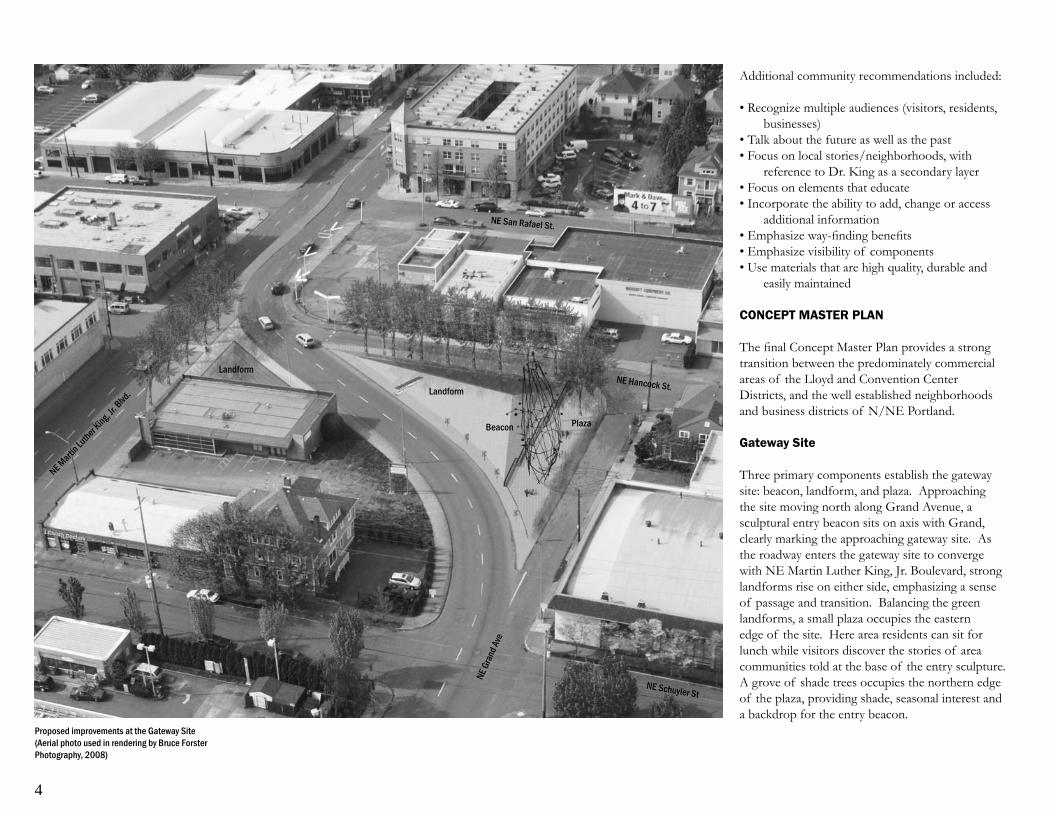
Additional community recommendations included:
Recognize multiple audiences (visitors, residents, • businesses)
Talk about the future as well as the past• Focus on local stories/neighborhoods, with •
reference to Dr. King as a secondary layerFocus on elements that educate• Incorporate the ability to add, change or access •
additional informationEmphasize way-fi nding benefi ts• Emphasize visibility of components• Use materials that are high quality, durable and •
easily maintained
CONCEPT MASTER PLAN
The fi nal Concept Master Plan provides a strong transition between the predominately commercial areas of the Lloyd and Convention Center Districts, and the well established neighborhoods and business districts of N/NE Portland.
Gateway Site
Three primary components establish the gateway site: beacon, landform, and plaza. Approaching the site moving north along Grand Avenue, a sculptural entry beacon sits on axis with Grand, clearly marking the approaching gateway site. As the roadway enters the gateway site to converge with NE Martin Luther King, Jr. Boulevard, strong landforms rise on either side, emphasizing a sense of passage and transition. Balancing the green landforms, a small plaza occupies the eastern edge of the site. Here area residents can sit for lunch while visitors discover the stories of area communities told at the base of the entry sculpture. A grove of shade trees occupies the northern edge of the plaza, providing shade, seasonal interest and a backdrop for the entry beacon.
Proposed improvements at the Gateway Site (Aerial photo used in rendering by Bruce Forster Photography, 2008)
NE Martin
Luther King, Jr
. Blvd
.
NE Hancock St.
NE San Rafael St.
NE Schuyler St
NE G
rand
Ave
Landform
Plaza
Landform
Beacon

5
Heritage Markers
In addition to improvements at the gateway site, a series of heritage markers are integrated into the boulevard streetscape. These markers complement improvements at the gateway site and extend the stories of the neighborhoods north along Martin Luther King, Jr. Boulevard.
The Concept Master Plan depicts a system including two types of heritage markers. Tall columns placed sequentially along the boulevard display large historic images. Lit at night, these markers have a scale and presence relevant at vehicular speeds. A series of smaller in-ground plaque markers complement the columns, providing information and directions at a pedestrian scale. The markers are located to correspond with points of historic interest in the surrounding community corridor.
This system of heritage markers encourages the community to honor individuals, cultural and historical events, or topics of signifi cance to the inner northeast neighborhoods of Portland. The markers also serve as a wayfi nding device while enhancing the pedestrian experience of the boulevard.
As envisioned through the public process, the fi nal Gateway and Heritage Markers Concept Master Plan focuses on the preservation of the area’s rich and culturally diverse history to enhance community image, promote a vibrant business district, improve the pedestrian experience along the boulevard, attract visitors and educate residents, both old and new, as to the struggles and achievements of the diverse communities that have historically called this area home.
The fi nal Gateway and Heritage Markers Concept Master Plan Report will serve as the foundation for ongoing work as PDC continues to secure funding for the fi nal design and construction of this important community project.
Lighting transforms tall column markers into historic beacons along the boulevard at night
Sidewalk markers provide additional information as well as directions to points of historic signifi cance in the neighborhoods bordering the boulevardHIBERNIAN HALL
Referred to as the “new club house” for Irish immigrants, Hibernian Hall was the social and cultural center for this community into the 1930s. From the 1950s-90s the building housed the Grace Collins Memorial Community Center (daycare), and is currently the Wonder Ballroom.
128 NE Russell StreetAbout a three-minute walk from here, due west


Section Two : Introduction


9
PURPOSE
The Concept Master Plan lays a foundation for the design and development of a gateway to Portland’s inner NE neighborhoods that will establish itself as both a distinct landmark and a source of civic pride. In addition, the project includes the development of a series of heritage markers along NE Martin Luther King, Jr. Boulevard, using the street to tell the stories of communities historically surrounding the boulevard.
The Concept Master Plan Report updates site analysis information, identifi es technical challenges, clarifi es current community goals and provides direction on the function and programming for both the gateway site and heritage markers. The report also includes a broad overview of area history and source references as an introduction to this area’s rich and diverse history.
PROJECT DESCRIPTION
The gateway site fl anks NE Grand Ave. as it converges with NE Martin Luther King, Jr. Blvd. at NE Hancock St. The larger of two parcels is triangular-shaped, approximately 15,500 square feet, bound by NE Schuyler Street, NE Hancock Street and NE Grand Avenue and is owned by the City of Portland’s Offi ce of Transportation.
The project area also includes the streetscape of NE Martin Luther King, Jr. Boulevard extending from the gateway site north to Rosa Parks Avenue. This section of the boulevard intersects the current neighborhoods of Piedmont, Woodlawn, King, Boise, and Eliot.
Ongoing work on this community project is funded through the PDC Oregon Convention Center Urban Renewal Area (OCCURA).
The NE Martin Luther King, Jr. Blvd Gateway and Heritage Markers project lies within the Oregon Convention Center Urban Renewal Area (OCCURA)
Map LegendOCCURA BoundaryProject ExtentGateway Site
PIEDMONT WOODLAWN
LLOYD DISTRICT
BOISE KING
ELIOT
NE Ainsworth
NE Alberta
NE Killingsworth
NE Broadway
NE Fremont
NE Russell
NE Skidmore
NE Rosa Parks
Mar
tin Lu
ther
Kin
g, Jr
. Blvd

10
Should others outside the OCCURA wish to continue the heritage markers, other resources will need to be identifi ed.
PROJECT BACKGROUND The origin of the Gateway and Heritage Marker Concept Master Plan can be found in previous community planning efforts begun over a decade ago by area residents and business owners.These planning documents include The Albina Community Plan (1993), Eliot Neighborhood Plan (1993), Martin Luther King, Jr. Boulevard Transportation Project (1998), and Martin Luther King, Jr. Blvd. Action Plan (2006).
Albina Community Plan (1993)
Adopted by the Portland City Council in July of 1993, The Albina Community Plan represented a comprehensive effort by citizens of NE Portland in collaboration with the Portland Bureau of Planning to chart the future development of their communities. Included in this comprehensive plan were the following goals and action items:
Reinforce Albina’s identity…celebrate its special • diverse architectural and cultural character
Provide opportunities for people outside • of the district to experience the positive characteristics of the Albina Community
Strengthen the Albina Community’s sense of • place through the promotion of its art, history and culture
Identity and protect the Albina Community’s • signifi cant historic districts, ensembles, sites and structures and other features
Develop district and neighborhood gateways that • mark the entrances in the Albina Community Plan area
Develop a unifi ed streetscape plan for NE Martin • Luther King, Jr. Boulevard
Improve the appearance of the boulevard and • enhance the experience of pedestrians
Eliot Neighborhood Plan (1993)
Adopted in 1993 the Eliot Neighborhood plan suggested the development of a park as a gateway at or near the area bounded by NE Hancock, NE Broadway, NE King and NE Grand including a memorial to Dr. Martin Luther King, Jr. While a park was not established at the gateway site at this time, a memorial sculpture of Dr. King was commissioned and installed at the Convention Center plaza in 1998.
Martin Luther King Jr. Boulevard Transportation Project Report (1998)
Issued in April, 1998 by the Portland Development Commission, the Portland Offi ce of Transportation, Metro and the Oregon Department of Transportation, this report engaged hundreds of local residents, business owners, property owners, and developers in identifying right of way improvements that would benefi t area neighborhoods and businesses. Design recommendations supported by the report include:
The creation of gateways that enhance the • distinctive identity of NE Martin Luther King, Jr. Boulevard
Support of elements contributing to a pedestrian-• friendly environment
Martin Luther King Jr. Boulevard Strategy Update and Action Plan (2006)
Developed by the Portland Development Commission in partnership with the Bureau of Planning, Bureau of Development Services and the Portland Offi ce of Transportation this action plan was approved by the Commission in June, 2006.
Martin Luther King, Jr. Blvd corridor looking north
Market on NE Martin Luther King, Jr. Blvd

11
Goals, strategies and actions supported by the plan include:
Develop a corridor that promotes local wealth • creation, engages and benefi ts a diverse group of stakeholders and creates a livable and functional main street
Practice broad, inclusive public involvement• Highlight the image and market on NE Martin •
Luther King, Jr. BoulevardImplement goal in the Albina Community Plan •
of creating a gateway into inner northeast neighborhoods north of Broadway
The development of a gateway site and heritage markers along the Boulevard serves a number of community planning goals. NE Martin Luther King, Jr.. Blvd continues to function as a major arterial thoroughfare moving north and southbound traffi c. Despite its Main Street designation, it is not perceived as a pedestrian friendly boulevard. The installation of the gateway and heritage markers will improve the streetscape and help emphasize NE Martin Luther King, Jr. Blvd’s role as a historic center of the community and as a vital corridor to work, shop, and recreate.
Gateway Site looking northwest - traffi c signs and temporary artHighway traffi c safety signs currently at the Gateway Site


Section Three: Background


15
THE STUDY AREA
The project area resides within the Oregon Convention Center Urban Renewal Area, located northeast of downtown Portland, and within the Albina Community Plan area. Beginning with the gateway site at the convergence of NE Grand Ave. and NE Martin Luther King, Jr. Boulevard, the study area extends north along the boulevard to Rosa Parks Way.
Bisecting the Albina Community, this section of the boulevard encompasses a rich past. Originally part of state highway 99E, the street formed one small segment of the west coast’s most important avenue of north-south mobility and commerce, the Pacifi c Highway. With the construction of Interstate 5 in the late 1960’s, traffi c fl ow was diverted from US 99E and the highway was ultimately decommissioned in the late 1980’s. Called Union Avenue at the time, the street continued to serve as a major route of local and regional commerce.
In 1989 the name of the street was changed from Union Avenue to Martin Luther King, Jr. Boulevard to honor the well-known civil rights leader. Regional planners began urging the city to consider transitioning the street from its highway status to a main street in 1997, although the street continues to carry a high volume of traffi c, currently carrying roughly 28,000 cars a day. NE Martin Luther King, Jr. Boulevard continues to maintain it’s relevance to regional commerce with Metro’s 2040 Growth Concept designating the boulevard from Northeast Broadway Street to Northeast Columbia Boulevard as a regional center ripe for development.
Union Avenue once served as a major streetcar route during the 1920s and 1930s. The streetcar lines were replaced by public buses in 1948.

16
Union Avenue looking south, shown here in 1975, was renamed Martin Luther King, Jr. Boulevard in 1989 in honor of this civil rights leader. Photo courtesy of the Oregon Historical Society.

17
Fremont Bridge ramps to Interstate 5 in the 1970’s resulted in the demolition of countless residences and businesses signifi cant to the remaining African American community.
Today, this area is again in transition. An increase of White and Latino residents, as well as an infl ux of new young entrepreneurs, has seen a corresponding decrease in the once vibrant African American community. While home ownership has risen and crime is abating, a subsequent increase in the price of area property and rents has forced many longtime residents and businesses to relocate once again.
An area of frequent transition, the resulting history embedded in the North/Northeast neighborhoods intersected by Martin Luther King, Jr. Boulevard is a rich and diverse one. The ongoing challenge for area communities focuses on how best to preserve this rich history while guiding future community development.
As NE Martin Luther King, Jr. Blvd. continues to evolve, communities in the surrounding corridor continue to work to enhance the street’s identity, function and character.
COMMUNITY HISTORY
NE Martin Luther King, Jr. Blvd cuts a straight line north-south through the Albina Community. Originally the land of the Clackamas, Multnomah and Clatskanie people, the area underwent intense change with the introduction of settlements such as the City of Albina platted in 1872.
Since that time, this area has continued to serve as the home for diverse communities facing frequent and often dramatic change. People migrating to this area have often been drawn by economic opportunity as well as seeking political and/or religious freedom.
Historically the area has served as home to numerous communities including Native American, Irish, Scandinavian, African American, German Russian, and Eastern European. Each group created strong centers of community through their churches, businesses, and neighborhoods.
Historic events have both challenged and galvanized these communities. World War II, the Great Depression, the Vanport fl ood, and the Civil Rights Movement all shaped these communities. Both national and local heroes arose as well contributing to these communities fi nding a strong civic voice.
Contemporary events have continued to bring change to the Albina Community. Construction of the Memorial Coliseum in 1956 took place in what was once the oldest part of the well-established African American community. In the 1960’s the construction of Interstate 5 again fractured neighborhoods. An anticipated expansion of Emmanuel Hospital that was never fully realized, as well as the construction of the
Platted in 1872, the original town site of Albina became home to a succession of Polish, Irish, Scandinavian, German-Russian and African American communities.
The 1960s brought activities of the Civil Rights Movement to the Portland such as this 1963 National Association for the Advancement of Colored People (NAACP) march in the Albina neighborhood.
“The Flooded City Undaunted”; this 1948 photo depicts a Rose Festival fl oat following the fl ood that decimated the largely African-American community living in Vanport.

18
Beginng at the convergence of NE Grand Ave. and NE Martin Luther King, Jr. Blvd. the project continues to Rosa Parks Way, intersecting fi ve inner Northeast neighborhoods along the boulevard corridor.
Williams and Mississippi to the west and Alberta to the east. These primary intersections also provide surrounding neighborhoods with freeway access to Interstate 5 to the west.
Institutions such as Portland Community College and Legacy Hospital provide key employment and educational opportunities in the area.
CURRENT PROJECT BOUNDARY
The Gateway and Heritage Markers Project begins at the convergence of NE Grand Avenue and NE Martin Luther King, Jr. Boulevard at NE Hancock and extends along the boulevard north to Rosa Parks Way.
Current planning for the project is funded through the Portland Development Commission’s Oregon Convention Center Urban Renewal Area (OCCURA). Tax increment fi nancing within such Urban Renewal Areas (URAs) provide funds that may then be re-invested in the URA that generated them. The current OCCURA, which includes the gateway site and NE Martin Luther King Jr. Blvd. as it continues north of Broadway, terminates at the boulevard’s intersection with Rosa Parks Way.
MASTER PLAN PROCESS
To assist the community in developing a Concept Master Plan, a multidisciplinary consultant team was identifi ed through a competitive selection process. Managed by the Portland Development Commission, this process included representatives of public agencies, area business owners and community representatives, including citizens involved in previous community planning .
Following selection of the consultant team, a Stakeholder Advisory Group (SAG) was created to guide the planning process. Including area citizens, business owners, and neighborhood representatives this committee was charged with an active advisory role, providing the consultant team and PDC with critical feedback throughout the process.
A Technical Advisory Group (TAG) was also assembled representing agencies and individuals to provide key technical information and review of ongoing Master Plan work. The TAG was charged with identifying technical issues and opportunities that might impact implementation of alternatives.
Planning progressed in three phases:
Phase I - Research • Phase II - Concept Alternatives• Phase III - Master Plan Refi nement•
The initial Research phase included the review of prevous planning documentation, extensive site analysis, research of the area history, and the exploration of ideas relevant to the “gateway” and “marker” components.
Following public review of Phase I work, the team developed three conceptual alternatives for both the gateway site and heritage markers. Each alternative presented unique elements and functions, providing a variety of options for public input. (See Appendix B for concept alternatives)
The concept alternatives were also reviewed with visiting professor Craig Barton, Chair of the Department of Architecture & Landscape Architecture at the University of Virginia. With broad experience in issues of cultural preservation and their interpretation through urban design,
PROJECT CONTEXT
The Gateway and Heritage Markers Concept Plan intersects fi ve Portland neighborhoods: Eliot, Boise, King, Piedmont and Woodlawn. While the project lies within the Albina Community Plan area, it is also strongly infl uenced by, and has the potential to impact, a larger community context.
South of the gateway site are both the Oregon Convention Center and Lloyd District. A landmark gateway site and improved pedestrian experience supports the attraction of visitors from these major centers into the business corridor surrounding NE Martin Luther King, Jr. Boulevard.
In addition, the gateway site and heritage markers will have a strong historical connection to the Dr. Martin Luther King, Jr. memorial, “The Dream”, located at the Oregon Convention Center. Building on the civic pride surrounding this installation, it is hoped that the gateway project can attract people north across Broadway Avenue to explore the community that was home not only to the local Civil Rights Movement, but to communities that continue to pursue his ideals of social and economic equality for all.
To the north of the current project area the neighborhoods of Eliot, Boise, King, Woodlawn, and Piedmont all hold similarly rich and diverse histories to be told. The northern extension of the boulevard also leads to the Delta Park area, the historic home of Native People along the Lower Columbia River, and later the site of the war-time housing development of Vanport.
Major intersections along the boulevard also provide important east-west connections linking the corridor to the thriving business districts along
Gateway Site
NE Grand Ave
Rosa Parks Way
ELIOTLLYODDISTRICT BOISE KING PIEDMONT
WOODLAWN
NE Martin Luther King, Jr. Blvd

19
Craig Barton brought to the team insights on assisting communities in the preservation and interpretion of their signifi cant cultural resources.
Based on subsequent work sessions, on-going public feedback and technical advisory review, a refi ned Concept Master Plan was developed and presented for fi nal public comment.
PUBLIC OUTREACH
As an extension of ongoing community planning efforts that began over a decade ago, the Concept Master Plan relied on an interactive public process to confi rm community goals, clarify the desired function of the gateway site and heritage markers, and build public awareness of current efforts.
In addition to active community participation on the SAG Committee, community outreach included three public events, one held during each of the critical planning phases. Through presentations, interactive work-sessions and open house displays,
community members were engaged to review project research, critique the concept alternatives and guide the refi nement of the fi nal Concept Master Plan.
An iterative review process was used, in which the team’s work was fi rst reviewed by the SAG Committee, with feedback incorporated and work refi ned as necessary for presentation at the Public Events. Public comments were then gathered and summarized for consideration by the SAG Committee as project refi nement continued. This iterative process ensured inclusion, accountability and a lively community dialogue throughout the planning process.
Additional public outreach during the project included participation in community events such as the City Hall Takeover, a community celebration of NE Portland businesses, civic groups and artists, as well as the annual Good in the Neighborhood event, an annual multicultural music and food festival held in N/NE Portland.
Community members participated in a series of three public events including presentations, working session and open house displays.
The public was further engaged through the distribution of project mailers to area residents, the display of project posters at area businesses to raise project awareness, and the display of project materials at area businesses to garner feedback. Public comment cards were distributed at public events and an interactive PDC project website was maintained to collect additional community input. (See Appendix C)
Interactive charrettes engaged community members in critiquing concept alternatives.


Section Four : Research


23
HISTORY OF THE NEIGHBORHOODS
The history of the inner North and Northeast neighborhoods intersected by Martin Luther King, Jr. Boulevard is a rich and diverse one. The people who migrated to this area often shared a common desire for personal and political freedom and economic opportunity. They were also divided at times by racial and ethnic prejudices as they struggled to fi nd common ground. Historically the area was home to Native American, Irish, Scandinavian, African American, German Russian, and Eastern European communities. Each group established strong ties to the area and built a sense of community pride through their neighborhoods, churches, community centers, schools, and businesses. Signifi cant human and natural events such as exploration and the fur trade, westward migration, world wars and civil wars, the Great Depression, the Vanport fl ood, and the Civil Rights Movement shaped all of these communities over time.
The Clackamas, Multnomah, and Clatskanie people—connected by language to the Upper Chinookan—were the original inhabitants of the land that became the city of Albina. With a rich economy based on fi shing, hunting, and gathering roots and other plant foods, the region’s Native residents thrived for thousands of years. Living in cedar plank homes, these indigenous people traveled rivers by cedar log canoes, inhabiting the land that is now Portland, the Delta Park area, and Sauvie Island. Non-native explorers and settlers arrived by sea and overland, and brought diseases that decimated, but did not eliminate the native people. Settlers took most of the Native’s ancestral lands through legislation like the Donation Land
Consecration of St. Nicholas Russian Orthodox Church, June 10, 1928
Ablina residents protest in 1973 during the proposed expansion of Emanuel Hospital.
Originally the site of the Eliot Grade School, the Knott Street Community Center opened in 1950. In the late 1960s, the local community successfully lobbied to name the center after Matt Dishman, the fi rst African-American Multnomah County sheriff and police offi cer in the city of Portland.

24
Claim Act of 1850. In fact, a donation land claim provided the land for the industrial city of Albina, annexed by Portland in 1891, which is the site for much of the area history included in the Gateway and Heritage Marker Concept Master Plan.
Industrialization swept across the United States in the nineteenth and early twentieth century, fundamentally altering the cultural and economic fabric of the country. Steamships facilitated both commercial trade with, and the migration of new settlers to, the young metropolis of Portland. Businessmen and politicians founded the city of Albina on the east banks of the Willamette River to serve as the center for their railroad and industrial enterprises. Once Portland became a western terminus for the Transcontinental Railroad, the need for skilled and semi-skilled workers in the Albina rail yards grew dramatically. Albina’s population swelled from 143 in 1880 to over 3,000
eight years later. Immigrants from China, Ireland, Poland, Germany and the Scandinavian countries, as well as Germans from Russia fl ocked to the city of Albina to fi ll jobs with the railroad, and other industrial jobs of the developing region.
Passenger travel by rail also increased during the late nineteenth century. Despite the existance of “Exclusionary Laws” in the Oregon State Constitution, clauses that prohibited Blacks from moving to the state, African Americans still found work as porters, cooks, and wait staff on passenger railcars. Many African American men were actively recruited from North and South Carolina to staff the restaurant, barber shop, and other service jobs at the grand Portland Hotel, which opened in downtown Portland in 1890.
These primary places of employment for African Americans provided enough economic stability to have their families join them in Portland
Union Pacifi c boiler shop crew, circa 1894
Albina railcar shop for Union Pacifi c, circa 1900

25
and served as the foundation of Portland’s African American community although the exclusionary laws remained part of the Oregon Constitution until 1926.
New workers arriving needed housing and small commercial businesses to supply their basic needs. Modest single-family dwellings, apartment houses for single working men, and commercial buildings were constructed from the low land along the riverfront to the bluff overlooking the Willamette River and the rail yards, and beyond to the fl at “prairie” that stretched to the east. As new immigrants arrived in the area, they populated these new “streetcar suburbs” and brought their native languages, cultures, and customs with them. In the early twentieth century, many languages could be heard along then Union Avenue. Volga Germans from Russia were so prevalent in the stretch between Fremont and Shaver and Williams and 15th Streets that it was called “Little Russia.” Neighborhood grocery stores were abundant and carried traditional foods for their German Russian, Polish, and Scandinavian patrons.
The built environment tells much of the history of the north and northeast neighborhoods along Martin Luther King, Jr. Boulevard. Fraternal lodges provided social space for immigrant populations to gather and share their native language, music, and dance as they reveled in tradition and adopted new customs. When those populations moved on, the same buildings served similar purposes for new groups that followed.
Churches were the spiritual center of these communities and also served as social centers for both newcomers and long-time residents. By the mid-twentieth century, discriminatory real estate and banking practices had restricted African Americans to the Albina area and many African American churches and their pastors found themselves standing at the heart of the Civil Rights Movement as the city’s Black citizens fought for access to equality in government,
housing, education, and employment. Schools have also always held a prominent place in the area, educating generations of neighborhood children, and sometimes conducting night classes to teach English to immigrants, or providing other adult education courses.
World War II served as the catalyst for a second mass migration to Portland. Edgar Kaiser recruited tens of thousands of workers from around the country to work at the Swan Island and Vancouver shipyards. In support of the shipyards, housing developments were built in and around Portland, the largest being Vanport. Portland’s historically small African American population soared from a few thousand to more than twenty thousand as workers responded to Kaiser’s call. A vibrant jazz and nightclub scene developed in the old Albina area along Williams and Vancouver
Portland Hotel, 1890-1951
Waiters at the Portland Hotel Dining Room

26
The Kaiser shipyards at Swan Island; 1942-1945

27
Avenues between Russell and Broadway. Mirroring a national history of discriminatory housing practices, most of Portland’s Black workers were forced to reside in Vanport during the war, and remain there until May of 1948 when the fl ooding Columbia River wiped out Vanport forever. In the aftermath of the fl ood, African American residents were steered into housing within the old Albina city boundaries and largely confi ned there through the practice of red-lining by banks, real estate fi rms, and insurance companies.
Vanport, constructed in 1943, was home to roughly 40,000 people.
The community was destroyed May 30, 1948 when a dike broke on the Columbia River
Signs such as this at a North Portland diner, 1943, became common during the war years.

28
The history of NE Martin Luther King, Jr. Boulevard—previously named Margaretta Street and Union Avenue—is also the history of a street. The boulevard has long functioned as a central route for the movement of people and goods, linking diverse communities even as modes of transportation changed over time. Early foot trails gave way to dirt roads, which in turn became streetcar lines with paved sidewalks. With the advent of the automobile came paved roadways and state highways. The street coupled with ferries served as the link between Oregon and Washington until the Interstate Bridge spanned the Columbia River in 1917. While the boulevard’s commerce
changed signifi cantly with the construction of Interstate Ave. and the Minnesota Freeway (I-5), it continues to serve as a major arterial street.
Even recent changes to the street and surrounding neighborhoods in the 1980s, 1990s, and the early years of the 21st century, refl ect the historical patterns of the area. Immigrants seeking a better life and opportunity continue to settle in the area, individuals and families resettle here from other parts of the country, and renovated and newly constructed commercial centers provide the necessary services for these new residents. They will form a new chapter in the rich and varied history that is North and Northeast Portland.
Commercial building facades along Martin Luther King, Jr. Blvd
Existing Gateway Site Mural along Martin Luther King, Jr. Blvd

29
SITE ANALYSIS
Gateway Site
Site analysis research was conducted to update technical information and to inform the ongoing design process for both the gateway site and the heritage markers to be placed along NE Martin Luther King, Jr. Boulevard.
The primary 15,500 square foot gateway site is a triangular lot owned by the City of Portland’s Offi ce of Transportation. The site is bound by NE Schuyler Street, NE Hancock Street and NE Grand Avenue and is located in the Eliot neighborhood.
The site is zoned EXd (Central Employment with a design overlay). This zone implements the Central Employment map designation of the Comprehensive Plan. The zone allows mixed-uses and is intended for areas in the center of the City that have predominantly light industrial and commercial development.
Currently the site is landscaped with temporary vegetation and artistic elements that have become weathered and vandalized throughout the years. Current site conditions are primarily vegetated with adjacent streets crowned to drain stormwater to in-road drains along NE Grand and NE Martin Luther King, Jr. Blvd. The site is bound on one side by NE Martin Luther King, Jr. Blvd., a high traffi c volume corridor, while the other sides are surrounded by commercial development and surface parking lots.
Existing site elements to remain include a utility corridor accommodating an electrical tower and accompanying power lines, a series of traffi c safety signs marking the s-curve on NE Grand Avenue and an existing billboard located directly behind the site, clearly visible on approach along NE Grand Avenue from the south. Additional site challenges include restricted pedestrian crossings due to unsafe conditions created by high traffi c volumes and limited visibility.
Gateway site looking north;Photo courtesy of Bruce Forster Photography, 2008
NE Schuyler StNE G
rand
Ave
NE Martin
Luther King, Jr
. Blvd
NE Hancock St.
NE San Rafael St.

30
Figure 2: Existing traffi c safety signsFigure 1: Existing powerline and easement
Site analysis diagrams illustrate existing conditions as well as opportunities for enhaned pedestrian crossings at the gateway site.
Figure 6: Proposed crossing locationsFigure 5: Proposed road closure Figure 4: Existing PDOT designated no crossing zone
Figure 3: Existing PDOT approved crossing locations
NE Martin Luther King, Jr. Blvd
NE Martin Luther King, Jr. Blvd
NE Martin Luther King, Jr. Blvd
NE Martin Luther King, Jr. Blvd
NE Martin Luther King, Jr. Blvd
NE Martin Luther King, Jr. Blvd
NE Schuyler StNE Schuyler StNE Schuyler St
NE Schuyler St NE Schuyler St NE Schuyler St
NE Hancock StNE Hancock StNE Hancock St
NE Hancock St NE Hancock St NE Hancock St
NE San Rafael StNE San Rafael StNE San Rafael St
NE San Rafael St NE San Rafael St NE San Rafael StNE Grand Ave
NE Grand Ave
NE Grand AveNE Grand Ave
NE Grand Ave
NE Grand Ave
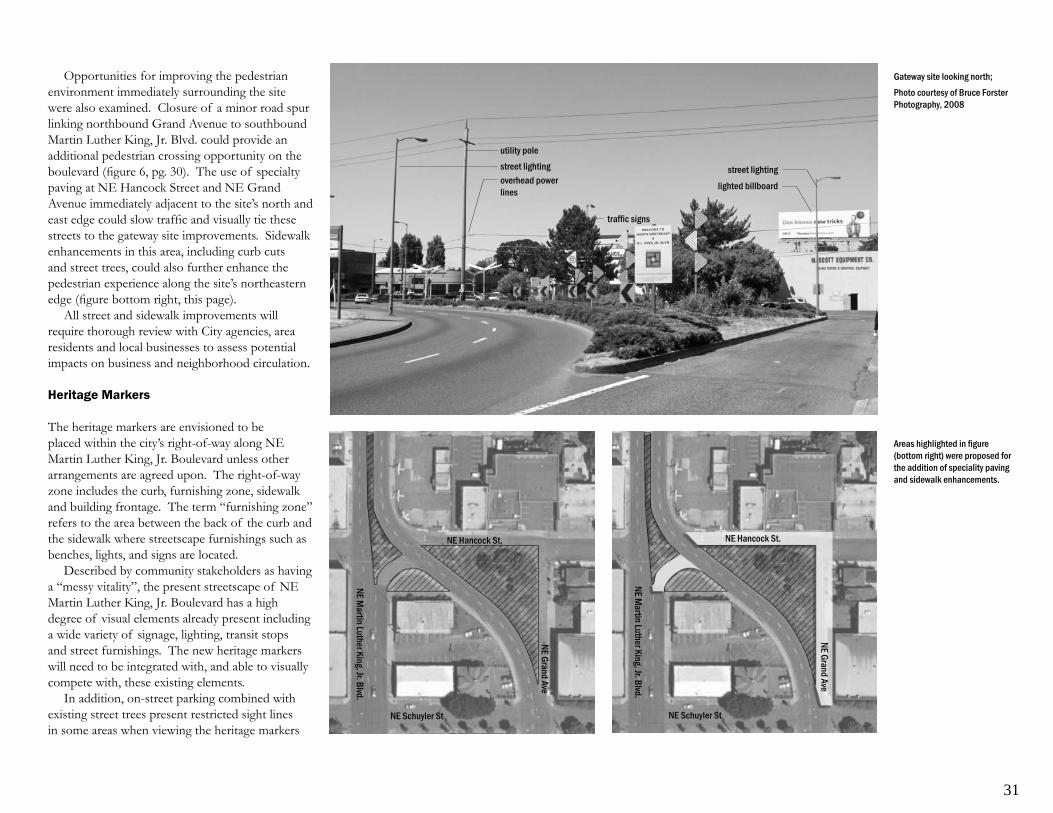
31
Opportunities for improving the pedestrian environment immediately surrounding the site were also examined. Closure of a minor road spur linking northbound Grand Avenue to southbound Martin Luther King, Jr. Blvd. could provide an additional pedestrian crossing opportunity on the boulevard (fi gure 6, pg. 30). The use of specialty paving at NE Hancock Street and NE Grand Avenue immediately adjacent to the site’s north and east edge could slow traffi c and visually tie these streets to the gateway site improvements. Sidewalk enhancements in this area, including curb cuts and street trees, could also further enhance the pedestrian experience along the site’s northeastern edge (fi gure bottom right, this page).
All street and sidewalk improvements will require thorough review with City agencies, area residents and local businesses to assess potential impacts on business and neighborhood circulation.
Heritage Markers
The heritage markers are envisioned to be placed within the city’s right-of-way along NE Martin Luther King, Jr. Boulevard unless other arrangements are agreed upon. The right-of-way zone includes the curb, furnishing zone, sidewalk and building frontage. The term “furnishing zone” refers to the area between the back of the curb and the sidewalk where streetscape furnishings such as benches, lights, and signs are located.
Described by community stakeholders as having a “messy vitality”, the present streetscape of NE Martin Luther King, Jr. Boulevard has a high degree of visual elements already present including a wide variety of signage, lighting, transit stops and street furnishings. The new heritage markers will need to be integrated with, and able to visually compete with, these existing elements.
In addition, on-street parking combined with existing street trees present restricted sight lines in some areas when viewing the heritage markers
Gateway site looking north;Photo courtesy of Bruce Forster Photography, 2008
Areas highlighted in fi gure (bottom right) were proposed for the addition of speciality paving and sidewalk enhancements.
utility pole
lighted billboard
street lightingstreet lighting
traffi c signs
overhead powerlines
NE Martin Luther King, Jr. Blvd.
NE Hancock St.
NE Schuyler St
NE Grand Ave
NE Martin Luther King, Jr. Blvd.
NE Hancock St.
NE Schuyler St
NE Grand Ave

32
Visibility of the heritage markers will need to compete with existing streetscape elements such as lights, signage and street trees.
Major east-west connections intersecting NE Martin Luther King, Jr. Blvd are highlighed
NE Russell
NE Broadway
NE Weidler
NE Schuyler
NE Hancock
NE San Rafael
NE Tillamook
NE Thompson
NE Sacramento
NE Brazee
NE Knott
NE Graham
NE Stanton
NE Morris
NE Monroe
NE Fargo
NE Cook
NE Ivy
NE Fremont
NE Beech
NE Failing
NE Shaver
Gateway Site
NE Martin Luther King, Jr. Blvd
NE Grand Ave

33
from passing cars. Where street trees are densely clustered along the boulevard, clear sightlines are limited to a zone between roughly 6 to 12 feet high (see image upper right, pg 32) when trees are in full leaf. The location of heritage markers will need to take advantage of openings in the current location and spacing of street trees on the boulevard
Based on the project’s scope, markers will begin near the gateway site and extend to Rosa Parks Way, a distance of over 37 blocks. Given this
NE Skidmore
NE Prescott
NE Going
NE Wygant
NE Humboldt
NE Mason
NE Alberta
NE Webster
NE Sumner
NE Church
NE Jessup
NE Jarrett
NE Simpson
NE Ashley
NE Holman
NE Dekum
NE Roselawn
NE Emerson
NE Killingsworth
NE Ainsworth
NE Rosa Parks
The heritage markers will require a suffi cient scale to relate to both existing street trees, street furnishings and building facades.
distance, as well as the high speed and volume of traffi c on the boulevard, the legibility of markers from both the vehicular and pedestrian perspective must be considered. Legibility from passing vehicles will require a location, frequency and scale able to achieve a sense of continuity along the extent of the project area. Many people however are also likely to experience smaller segments of the streetscape as they go about their daily excursions. Therefore the location of the heritage markers must also be
accessible and frequent enough to engage people moving within a more limited area, possibly by bike or on foot.
A fi nal consideration in the placement of the markers is their proximity to major east-west intersections.along the boulevard. These active hubs offer opportunities to not only engage additional people as they cross NE Martin Luther King, Jr. Blvd., but also to highlight the history and stories that connect the greater community as a whole.

34
Site analysis of the boulevard right-of-way examined three primary locations for the installation of markers; the furnishing zone (FZ), the primary sidewalk zone and sidewalk extensions (such as curb bulb-outs). Each zone offers unique opportunities and constraints.
The furnishing zone (FZ), from the back of the curb to the sidewalk, allows for the installation of both horizontal and vertical pieces but these must integrate with other street furnishings including street trees.
Extending the area into the primary sidewalk would require pieces to be two-dimensional and not disruptive to pedestrian traffi c.
Installation in areas such as curb bulb-outs may be three dimensional but these occur only sporadically along the boulevard and objects can not disrupt traffi c or pedestrian views at intersections.
FZ ROW FZ ROW FZROW

35
GATEWAY AND MARKER TYPOLOGIES
To assist community participants as well as the design team to envision the broadest possibilities for interpreting the project components of “gateway” and “marker”, the team compiled an overview of typologies. Exploring how people have used physical form to record important people, places, events and ideas, this overview incorporated imagery of monuments, memorials, gateways and historic markers (see pgs. 36 and 37 for examples of images presented).
Typologies explored included monuments and memorials of ancient time such as the Egyptian pyramids and the Taj Mahal. Commemorating culturally signifi cant individuals, these gestures where of a grand scale built to display power and inspire awe.
Smaller yet equally powerful monuments have also payed tribute to collective citizens rather than to individuals. Such is the case at the Vietnam Veterans Memorial in Washington D.C. Here it is the every day individual, the soldier, that is remembered and visitors are welcomed into the site to pay tribute on a personal level.
In paying tribute to citizens, these monuments often use a physical manifestation, such as statuary in the commemoration. Many contemporary works have seen instead the use of “absence” as a way of remembering. This is seen in the Oklahoma City National Memorial where empty chairs represent those lost, as well as in the temporary light installation marking the site where lives were lost in the World Trade Center bombing.
The creation of spontaneous and/or temporary events by the public is another form of commermoration seen in such events as the AIDS Memorial Quilt installation in Washington, D.C. or the spontaneous shrine to Princess Diana amassed at the gates of Kensington Palace after her death.
In capturing signifi cant and yet at times abstract ideas such as the celebration of “the state” by
America’s Statue of Liberty these monuments have become icons not only of people and places but of the ideals they hold most dear.
Gateways are another intervention that has not only marked boundaries and places of entry, but have become signifi ers of important cultural ideals. France’s Eiffel Tower is one such example, originating as a gateway to the 1989 World Exposition, but over time becoming a landmark and icon representing a French culture bound by common ideals.
Gateways have often been seen as announcements of arrival and are celebratory in nature. Often distinctive in character they have taken many forms from the scale of the ancient gates of China to the modest stone gates marking Portland’s Laurelhurst neighborhood. Often conceived as overhead arches, a sense of “gateway” has also been created using a series of objects, singular landmarks and other interventions that function to mark passage.
Often smaller in scale and serial in nature, markers have illustrated a similar diversity of form used to convey meaning. Historically markers have been used for a variety of functions including way-fi nding, education and remembrance. By identifying
signifi cant people, places, or events markers have also contributed to the telling the story of communities and projecting the values they hold signifant.
This exploration of typologies was presented to participants at the fi rst Public Open House event of the Gateway and Heritage Markers Concept Master Plan. In addition to illustrating a breadth of function and design, the research assisted participants in framing critical project questions such as, “what will resonate in Portland”, “what makes our story unique and specifi c to place”, and “how do we want this project to function”?
Vietnam Veterans Memorial - Washington D.C. Eiffel Tower - Paris, France

36
The Great Light Way, 1914-1930s - SW 3rd Avenue, Portland, OR
Oklahoma City National Memorial - Oklahoma City, OK
Collins Traffi c Circle - Portland, OR The Gates, 2005 - New York, NY
Lighted Gateways - Omaha, NB
Vietnam Veterans Memorial - Washington D.C.
Tribute in Light, 2004 - New York, NY
Laurelhurst Neighborhood Gateways - Portland, OR

37
Chess Park - Glandale, CA
Tanner Creek Sidewalk Marker - Pearl District, Portland, OR
Lighting and Interpretive Signage - Eastbank Esplanade, Portland, OR
Historical Marker -London, England “The Dream” - Convention Center Plaza, Portland, OR
LAX Airport Entry Road - Los Angeles, CA


Section Five : Concept Master Plan


41
DESIGN
Layers of history, commerce, and community, wrap around the proposed gateway site to this unique district. Stories overlap and combine in the corridor bordering NE Martin Luther King, Jr. Boulevard as it moves north. The gateway becomes a threshold into one of Portland’s most richly diverse cultural districts while the boulevard becomes a line marking the intersection of different people, places, cultures and events across time.
Residents, business owners, developers and neighborhood representations worked with PDC and the consultants to craft a Concept Master Plan to not only preserve this heritage but to build upon it in securing a vibrant future for the communities of Portland’s inner northeast neighborhoods.
CONCEPT ALTERNATIVES
To assist community participants in defi ning the desired functions as well as the story to be told through the Gateway and Heritage Markers project, a series of concept alternatives were developed allowing participants to compare and contrast a variety of different ideas (see Appendix B for Concept Alternatives).
Through the review and critique of these concept alternatives, community participants identifi ed the desired function of the gateway and heritage markers as follows:
The creation of a clear “threshold”, announcing • arrival to a unique district of Portland and the emphasis of this character along the boulevard
The preservation, interpretation and celebration • of a broad and inclusive history of area communities
Additional community recommendations included:
Recognize multiple audiences (visitors, residents, • businesses)
Address the future as well as the past• Focus on local stories/neighborhoods, with •
reference to Dr. King as a secondary layerFocus on elements that educate• Incorporate interactive elements (ability to add, •
change, or access additional information)Recognize potential wayfi nding benefi ts• Emphasize the visibility of components• Use materials that are high quality, durable and •
easily maintained
The Concept Master Plan incorporates these community recommendations and set a strong direction for the fi nal design and implementaion of the NE Martin Luther King, Jr. Boulevard Gateway and Heritage Markers project.
CONCEPT MASTER PLAN
Gateway Site
The site selected for the gateway location provides a clear transition between the predominately commercial areas of the Lloyd District and the well established neighborhoods and vibrant business districts of North/Northeast Portland.
Strong ThresholdThe Concept Master Plan for the gateway
site relies on a pair of strong landforms fl anking either side of NE Grand as it merges with NE Martin Luther King, Jr. Boulevard to create a clear threshold and gateway as drivers head north into the Albina Community. Entry signs announce the
transition from one district to another. Landscaping emphasizes the forms while softening the entry and providing seasonal interest.
Gathering SpaceBalancing these landforms is a small plaza
along the site’s eastern edge. Recognizing that the gateway site is not a primary gathering space within the neighborhood given its adjacency to high traffi c volumes and distance from current community amenities, the design nonetheless accommodates small groups of people for events as well as the occasional lunchtime visitor. The plaza incorporates specialty paving, seating and lighting and remains open to NE Grand to ensure clear visibility and safety.
North Star Entry SculptureLocated within the plaza, the “North Star”
entry sculpture serves as a visual beacon aligned with vehicular traffi c northbound on the long axis of NE Grand Avenue. Rich with symbolism, the North Star has historically been used by many cultures as a wayfi nding device. Within the context of the gateway, it is used to reference the story of migration familiar to many of the cultures and communities that have come live in the neighborhoods of Albina. The sculpture itself is an abstraction of the night sky wrapping around this point in time and space with the North Star continuing to serve as a guiding light.
Immigrant MapA map at the base of the North Star Entry
Sculpture is one example of how this modest plaza space can help tell the story of the many immigrant groups who have made their homes here and the others yet to come. Depicting relative bearings from around the globe, this map places Albina metaphorically at the center indicating how diverse communities have come from all over the world to make this place their home.

42
LEGEND 1. Gathering Space2. Plaza Seating3. North Star Sculpture and Immigrant Map4. Storm Water Swale
5. Large Vegetated Landform6. Small Vegetated Landform7. Tree Grove8. Neighborhood Entry/Exit Signage
Proposed Gateway Site improvements looking north
4
1
2
5
6 8 8
7 3

43
Tree GroveAt the north end of the plaza is a grove of
shade trees providing a backdrop to the North Star Sculpture as well as bringing shade and seasonal interest to the plaza.
Stormwater SwaleA vegetated swale integrating native plants is
used to manage and cleanse storm water runoff from the plaza area. The swale also creates a barrier to deter dangerous mid-block pedestrian crossings along the east edge of the site.
Interpretive engravings at sculpture’s base could provide information about Northeast Portland’s rich immigrant history
“Yes, we need a chart;we need a compass; indeed, we needsome North Star to guide us into a
future shrouded withimpenetrable uncertanties.”
Dr. Martin Luther King, Jr.
From the ‘Where do we go from here?’ speech Annual Report Delivered at the 11th Convention of the Southern Christian Leadership Conference
16 August 1967, Atlanta, Georgia
A GATHERING POINTDiverse populations have been migrating to Portland for many years, and of Portland’s diverse network of neighborhoods, the North-Northeast neighborhoods have historically been home to the richest succession of peoples and cultures.
The North Star Sculpture represents the concept of a sculptural beacon, illuminated at night to mark entry into the Northeast neighborhoods.

44
Heritage Markers
The heritage markers are seen as a complement to the gateway site improvements. Depicting historic images and information these markers are integrated into the streetscape of the boulevard, extending the stories of the neighborhoods along Martin Luther King, Jr. Boulevard.
The Concept Master Plan envisions a two tiered system of markers, illustrating the history of the neighborhoods in two distinct ways, yet both depicting an inclusive view of history from pre-settlement to the present.
The primary markers on the boulevard are large vertical markers. Distributed equally along the length of Martin Luther King, Jr. Boulevard every few blocks, these markers use large scale pictures to tell the history of surrounding neighborhoods. Each marker illustrates a
general theme relevant to the history of the area. Examples of these themes might include: architecture, people, commerce, or immigration. Text is used to interpret the images and provide stories relating to the historic theme of the marker. In the evening, the markers could be lighted to create a dramatic atmosphere along the boulevard.
In addition to the tall markers, a series of smaller, two-dimensional markers embedded in the sidewalk are also distributed along the length of the boulevard to Rosa Parks Way. These markers are placed due east or west of locations of historic community importance (see mapping, pg. 45 for examples). Easily read by passing pedestrians, each marker is made of durable, vandal-resistant materials, and is inscribed with a description of, and directions to, a particular person, place, or event of historic
HIBERNIAN HALLReferred to as the “new club house” for Irish immigrants, Hibernian Hall was the social and cultural center for this community into the 1930s. From the 1950s-90s the building housed the Grace Collins Memorial Community Center (daycare), and is currently the Wonder Ballroom.
128 NE Russell StreetAbout a three-minute walk from here, due west
Large vertical markers are shown during both night and day Sidewalk markers allow pedestrians to easily access historic information about their community.
community importance. While the gathering and fi nal selection of historic content will be included in the next phase of work, the Concept Master Plan includes a preliminary list of historic people, places and events to serve as a starting point for generating a strong community dialogue.

45
HISTORIC CONTENT
Community goals supported by the Gateway and Heritage Marker Concept Master Plan include:
building on the civic pride of residents• integrating the unique identity of adjacent • neighborhoodscelebrating local heroes, history, every-day • citizens and their storiesenhancing the pedestrian experience• increasing the educational value for residents • and visitors
While the gathering and fi nal selection of historic content will be included in the next phase of work, the Concept Master Plan includes a preliminary list of historic people, places and events to serve as a starting point for generating a strong community dialogue. See Appendix A for Neighborhood People and Places Legend.
Neighborhood People and Places Map; see Appendix B for Legend
PIEDMONT WOODLAWN
LLOYD DISTRICT
BOISE KING
ELIOT
NE Ainsworth
NE Alberta
NE Killingsworth
NE Broadway
NE Fremont
NE Russell
NE Rosa Parks
Mar
tin Lu
ther
Kin
g, Jr
. Blvd


Appendices


49
Appendix A
NEIGHBORHOOD PEOPLE AND PLACES LEGEND
1. Woodlawn District: Bordered by Ainsworth St, Columbia Blvd, Martin Luther King, Jr. Blvd. and 22nd St. A small village, Woodlawn become a regular overnight stop on the railroad linking Portland and Vancouver. With no bridge over the Columbia River until 1917, rail travelers stopped in Woodlawn overnight before taking the Columbia River Ferry. Rail station built 1888.
2. Peninsula Park: 700 N Portland Blvd Previously used as a roadhouse and racetrack for quarter-mile horse racing, this park was built as part of Portland’s City Beautiful Movement. The park is home to the sunken rose gardens and gazebo that have been the site of many Rose Festival events. Built 1912.
3. Bethel AME Church: 5828 NE 8th (currently)Bethel AME is one of the oldest African American churches in the city. First located on NW 10th, then for many years on N. Larrabee, the church has been located at 5828 NE 8th since 1959. A. Phillip Randolph of the Pullman Porters Union spoke in the original location. 1929.
4. Vann and Vann Funeral Home: 5211 N WilliamsFirst African American funeral home in Portland. C. Don Vann and Roberta Vann both held funeral director’s licenses and provided important service to African American community at a time when many other funeral homes would not provide those services.
5. Bow and Arrow Culture Club: 5048 NE 10thThe Bow and Arrow Culture Club offered a
place for Indians to dance, drum, and gather in community. 1970’s.
6. Mallory Avenue Christian ChurchHoused the NE YWCA for many years after the Williams Ave Branch was closed and sold, despite community objections. Oral histories on this topic available at PSU.
7. St. Andrews Catholic Church: NE 8th and AlbertaGerman immigrants were the fi rst parishioners at St. Andrews, and they were followed by Irish immigrants. The church operates a legal clinic that serves low-income clients and was involved in social justice issues in the 1960s-80s. Established 1929.
8. King Neighborhood Facility: NE 6th and GoingThe King Neighborhood Facility has served as meeting place for the N/NE neighborhoods. Founded 1970’s.
9. Highland United Christian ChurchHighland United Church of Christ housed Head Start, War on Poverty programs and the George Jackson Memorial Free Breakfast Program. 1970’s.
10. Maxey’s Grocery and Barber Shop: 4601-03 N WilliamsCharles Maxey left Texas to come work in the Portland shipyards. He opened Maxey’s Barber Shop and then Better Buy Grocery. Maxey was an activist in the NAACP and the Urban League and was a founding member of the Portland chapter of Kappa Alpha Psi. Arrived 1943.
11. Edna Robertson Residence: Grand and PrescottEdna Robertson worked for the Model Cities Program. She became the fi rst coordinator for the Northeast Coalition of Neighborhoods, and the director of King Neighborhood Facility and in
those positions fought for economic development, public safety, and an end to discrimination in inner N/NE neighborhoods. Arrived in the 1950’s.
12. Log Front Tavern: NE Martin Luther King, Jr. Blvd and PrescottOne of numerous taverns along then Union Avenue where German immigrants and descendants gathered regularly.
13. Second German Congregational Church: NE 8th and Skidmore (early on NE Mallory)One of the churches built by the German Russian immigrants that settled in this area of N/NE Portland. This area became known as “Little Russia.” The church was the center of the religious and social lives of those early immigrants. Late 19th and early 20th centuries.
14. Norwegian Danish Methodist Episcopal: N Vancouver and SkidmoreOne of the hallmark church buildings of the Scandinavian immigrant population in NE Portland. Today it is the home of First Zion AME. Established 1909.
15. Maranantha Church of God: 4222 NE 12thTwo of this church’s pastors were also widely known and respected civic leaders, the Rev. Wendell Wallace (1960’s-70’s) and Rev. John Garlington (1979-80’s).
16. Finnish Congregational Church: N Mason and AlbinaThis church served the Finnish immigrant community. Early 20th century.
17. Geneva’s (formerly): 4228 N WilliamsGeneva’s restaurant and nightclub was owned and operated by Paul and Geneva Knauls. The club featured live music, an annual Ebony fashion show, was a regular stop for many of the 1970s-80s.

50
Portland Trailblazers, and was a cultural icon. It was leveled by fi re in the 1980’s.
18. Allen Temple CME: 4236 NE 8thBegun at the site of the Second German Congregational Church, Allen Temple has been an important religious institution in the African American community. 1949.
19. German Brethren Evangelical Church: NE Garfi eld and MasonOne of the churches built by the German Russian immigrants that settled in this area of N/NE Portland. This area became known as “Little Russia.” The church was the center of the religious and social lives of those early immigrants. Late 19th and early 20th centuries.
20. Otto and Verdell Rutherford Residence: 833 NE ShaverVerdell and Otto Rutherford were leaders in Oregon’s Civil Rights Movement. They ran much of the campaign for the Public Accommodations Law out of their home on NE Shaver. 1950’s.
21. Repp Brothers Meat and Groceries: NE Martin Luther King, Jr Blvd and FailingTypical small commercial business that provided the necessities of the surrounding neighborhood, many of them owned by German Russian immigrants. 1899.
22. Weimer’s Hardware and Furniture: 3942 NE Martin Luther King, Jr Blvd (now Hankins Hardware and Heritage Bldg)The Weimer family owned and operated a hardware and furniture store for many years. The upstairs ballroom in furniture store was closed due to anti-German sentiment during WWII. 1910’s.
23. Polish Library Building Association: 3832 N InterstateThe Polonia, Polish immigrants, joined the
National Polish Alliance in 1911 and soon began construction on the Polish Hall, which housed meetings, dinners, dances, and the multi-lingual holdings of the library. Built in 1900s.
24. Black Panthers: 3819 NE Martin Luther King, Jr BlvdThe Portland branch of the Black Panther Party established the Fred Hampton Free Clinic, ran a free breakfast program out of Highland Church, and had their headquarters at this location. Clinic established 1969.
25. St. Paul Evangelical and Reformed Church: NE 8th and FailingOne of the churches built by the German Russian immigrants that settled in this area of N/NE Portland. This area became known as “Little Russia.” The church was the center of the religious and social lives of those early immigrants. 1904.
26. Lehl and Popp Groceries: NE 10th and Failing Typical small commercial business that provided the necessities of the surrounding neighborhood, many of them owned by German Russian immigrants. 1910’s.
27. Danewolf Groceries and Meats: NE 13th and FailingTypical small commercial business that provided the necessities of the surrounding neighborhood, many of them owned by German Russian immigrants. 1919.
28. Vancouver Avenue First Baptist Church: 3138 N VancouverFounded by Dr. O.B. Williams, Vancouver Avenue First Baptist Church grew from one rented room in a Mason’s hall on Russell Street into the established congregation of today on N. Vancouver Ave. 1945.
29. George Repp Residence: 386 Beech St
George Repp, a German Russian, owned a local grocery store and meat market. He was one of the principle organizer of the Volga Relief Society. Early 20th century.
30. Trupp Shoe Repair: 3619 NE Martin Luther King, Jr Blvd and Beech (SW corner)Typical small commercial business that provided the necessities of the surrounding neighborhood, many of them owned by German Russian immigrants. 1910’s.
31. House of Sound Records: 2628 N WilliamsA locally run business and cultural institution that sold “the best of HI-Fi Records”. Once owned by Jefferson High School and NFL football legend Mel Renfro and Cliff Walker.
32. Free Evangelical Brethren Church: 3605 NE MalloryOne of the churches built by the German Russian immigrants that settled in this area of N/NE Portland. This area became known as “Little Russia.” The church was the center of the religious and social lives of those early immigrants. Late 19th and early 20th centuries.
33. Albina Head Start: NE 7th and Fremont The local center for the federal Head Start Program, Albina Head Start works with the city’s low-income families to provide access to education and development skills for infants and children. Established 1965.
34. Zion Congregational Church: NE 8th and FremontOne of the churches built by the German Russian immigrants that settled in this area of N/NE Portland. This area became known as “Little Russia.” The church was the center of the religious and social lives of those early immigrants. Late 19th and early 20th centuries.

51
35. Immaculate Heart Church: 2910 N WilliamsFounded as St. Mary’s by Irish Catholic immigrants who came to work as laborers for the railroads, the church became an important parish for African American Catholics and the name was changed to Immaculate Heart. Founded 1819.
36. NAACPThe NAACP strives for the political, educational, social, and economic equality of rights of all persons the end to racial hatred and racial discrimination. The Portland chapter of the NAACP is the oldest continually chartered chapter west of the Mississippi River. Founded 1913.
37. Ebenezer German Congregational Church: NE 7th and StantonOne of the churches built by the German Russian immigrants that settled in this area of N/NE Portland. This area became known as “Little Russia.” The church was the center of the religious and social lives of those early immigrants. Late 19th and early 20th centuries.
38. Cox Funeral Home: 2736 NE RodneyProvided important service to African American community at a time when many other funeral homes would not provide those services.
39. Blessed Martin Day Nursery: 2805 N WilliamsOperated by Immaculate Heart Church, the nursery provided daycare during the years of World War II.
40. Mayfi eld and Juretta Webb Residence: 2807 NE 8thMayfi eld and Juretta Webb came to Portland in the mid 1950s. He completed his law degree at the Northwest School of Law and served as NAACP president. War on Poverty leader, and a founder of the Albina Corporation. Juretta worked as a nurse and activist. Arrived 1955.
41. Matt Dishman Community CenterNamed for Vanport Sheriff, and then Multnomah County Sheriff ’s Offi cer, Matt Dishman, this facility has served the youth and adult population of the surrounding neighborhoods for over fi ve decades. Originally, called the Knott Street Community Center. Home of the Knott Street Boxing Club, which has produced nationally recognized boxers, several members are in the Oregon Sports Hall of Fame. 1950’s - present.
42. Emanuel Hospital: 2801 N Gantenbein Founded by the Lutheran Church, Emanuel Hospital is today Legacy Emanuel Hospital and Health Center. In the 1960’s an expansion plan resulted in the demolition of 188 houses and businesses. That process, preceded by the massive relocation and demolition of African American-owned homes and businesses for the Memorial Coliseum and the Minnesota Freeway (I-5), left many neighborhood residents embittered. Hospital founded 1912, expansion plan 1960’s.
43. St. Phillips Episcopal ChurchThe church of the Rev. Lee Owen Stone, a respected clergyman of Portland’s African American community. He was on the board of the Urban League of Portland and fought for reform in the trade unions during WWII. A daycare was named in his honor that is still in existence today.
44. White Eagle Saloon: 836 N RussellServing as a meeting places for Polish immigrants arriving in the area, the Bialy Orzel (White Eagle) drew instant recognition with Polish railroad workers and other laborers by it white eagle on a red background that is a symbol of Poland. 1890s.
45. Hibernian Hall: 128 NE RussellReferred to as the “new club house” for Irish immigrants, Hibernian Hall was the social and cultural center for the community into the 1930s. From the 1950s-90s the building housed the Grace
Collins Memorial Community Center (daycare), and currently is the Wonder Ballroom. Built 1914.
46. Urban League of Portland: 2525 N Williams (currently)The local affi liate of the National Urban League, which is the nation’s oldest and largest community-based organizations devoted to ensuring equality and access by African Americans to the economic and social mainstream of America. Founded 1945.
47. Mary Beehan McCarthy Residence: NE Russell and Martin Luther King, Jr BlvdMary Beehan McCarthy continued to own and operate the Weidler Butcher Market after the death of her husband. She raised their children in the home located directly behind the market, which faced Victoria Street. Early 20th century.
48. E.D. and Beatrice Cannady Residence: 2516 NE 26th AveE.D. and Beatrice Cannady were the owners and editors of The Advocate newspaper. E.D. worked at the Portland Hotel for many years. Beatrice actively worked for better “race relations” and hosted many interracial teas at their home in Irvington. 1903 - 1933.
49. Woodmen of the World: adjacent to 128 NE Russell (now Toro Bravo)Part of the national fraternal organization founded to provide insurance to workers working in the woods. Founded 1890.
50. St. Stanislaus Church: 3916 N InterstateEstablished at the request of Polish immigrants for a church that would hold Mass in their native language, St. Stanislaus remains at the religious and cultural center of the Polish community in the Portland metropolitan area. Established 1907.
51. Cotton Club (formerly): 2125 N. VancouverThe nightclub was owned and operated by Paul

52
and Geneva Knauls and was the venue for a wide variety of entertainment, from jazz and blues, to comedy, exotic dancers, and female impersonators. The club hosted many of the nation’s top Black musicians and celebrities.
52. Portland American Indian Center: 611 N Tillamook (now at 5135 NE Columbia Blvd)Formed by urban Indians as a place to nurture Indian culture, they strove to incorporate traditions from the many tribal members who gathered there. The PAIC organized the fi rst modern Pow Wow in the area in 1969. Originally formed 1959.
53. Williams Avenue YWCA : 6 N TillamookPortland’s African-American women organize to meet the needs of black women and girls. Closed in an unpopular move by the Portland YWCA, the building now houses the Billy Webb Elks Club and continues as a hub for social activities in the Black community. YWCA closed in 1950’s.
54. Dean’s Barber Shop/Beauty Salon: 213-15 NE HancockHusband and wife team Benjamin Dean and Mary Rose opened Rose’s Beauty Salon in their home and later opened and operated Dean’s Beauty Salon and Barber Shop. The business is still owned and operated by the family.
55. Allen and Louisa Flowers & Sons Residences: 1745, 1803, and 1811 NE 1stThese three homes were built by and for one of Portland’s earliest Black families, the Flowers. Today one of the houses is home to longtime Elliot Neighborhood resident and activist, Pauline Bradford.
56. Mt. Olivet Baptist Church: NE 1st and Schuyler (currently at 8501 N Chautauqua)First African American church fi nanced and constructed in Portland. The site of nationally
known lecturers and movement leaders--A. Philip Randolph, Marcus Garvey, and Addie Hunton--and the church of Rev. John Jackson, a local leader in the Civil Rights Movement. 1921.
57. Dude Ranch: 240 N BroadwayAt the height of its popularity, The Dude Ranch was considered “the hottest Black and Tan supper club west of the Mississippi,” and hosted many of the biggest names in jazz and blues of the era. 1940’s.
58. Weidler Butcher Market: NE 1st and WeidlerThe Weidler Butcher Market was the fi rst meat market and one of the fi rst businesses in the area. Early 20th century.
59. Johan Poulsen - Inman Poulsen Lumber: NE 11th and Multnomah (approx)Johan Poulsen was of the partners in the Inman-Poulsen Lumber Company, a signifi cant lumber products business that operated near the present-day Ross Island Bridge. Poulson built a Queen Anne home that showcased beautiful woodwork where Double Tree Hotel and part of Lloyd Center now stand. Early 20th century.
60. Golden West HotelThe Golden West Hotel was the only accommodations that allowed African American guests until the Public Accommodation Law passed in 1953. Owned by W.D. Allen, the Golden West was considered the “largest and best equipped hostelry for colored people west of Chicago.” 1906-1930.
61. Norse Hall: NE 11th and EverettThe Norse Hall quickly became the center of social activities for the Norwegian and other Scandinavian communities around the city of Portland. With space for meetings, a library, and a dance ballroom the Norse Hall provided the space for a diverse set
of needs of the immigrant generation and their descendents today. Built 1928.
62. Albina Rail Yards: Historically located at west end of N Russell along the banks of the Willamette River The city of Albina developed along with the Oregon Railway and Navigation Company, and later the Union Pacifi c Railroad. The Albina Rail Yards, provided work for many immigrant laborers and African Americans. Those workers became the residents of many of the surrounding neighborhoods. Late 19th and early 20th centuries.
*Delta Park Area: N Denver Ave and Martin Luther King, Jr Blvd 9,000 years ago the area now called Delta Park were traditional ceremonial grounds for Indians from across the region. The annual Rose Pow Wow and Encampment is still held in this location. The area also housed Vanport before it was destroyed by fl ood waters in 1948.
*Lower Willamette RiverThe land along lower Willamette/surrounding area has been home to the Chinook, Clackamas, Multnomah, and Clatskanie People for at least 9,000 years.
*Entry not located on Neighborhood People and Places map.
Selected Bibliography
• “It’s About Time: Black Panther Party Legacy & Alumni.” http://www.itsabouttimebpp.com/index.html.
• Bosco-Milligan, Foundation. Cornerstones of Community: Buildings of Portland’s African American History. Portland, Or.: Bosco-Milligan Foundation, 1995.

53
• Dietsche, Robert. Jumptown: The Golden Years of Portland Jazz, 1942-1957. Corvallis: Oregon State University Press, 2005.
• MacColl, E. Kimbark. The Growth of a City: Power and Politics in Portland, Oregon, 1915 to 1950. Portland, Or.: Georgian Press, 1979.
• The Shaping of a City : Business and Politics in Portland, Oregon, 1885-1915. Portland, Or.: Georgian Press Co., 1976.
• MacHaffi e, Ingeborg Nielsen. Danish in Portland: Past and Present : Serving Where Seeds Are Planted, 1882-1982. Limited ed. Tigard, OR: Skribent Press, 1982.
• McLagan, Elizabeth, and Oregon Black History Project. A Peculiar Paradise : A History of Blacks in Oregon, 1788-1940. 1st ed. Portland, Or.: Georgian Press, 1980.
• Schreiber, Steven. “The Volga Germans in Portland.” http://www.volgagermans.net/portland/index.html.
END

54
Appendix B
CONCEPT MASTER PLAN ALTERNATIVES
Concept Alternatives were generated to help community participants explore a range of programmatic, thematic and aesthetic options for development of both the gateway site and the heritage markers. These Concept Alternatives were presented at the second Public Open House event where community members worked in small teams to review and analysis each alternative. The alternatives presented were as follows:
GATEWAY CONCEPT A - NORTH STAR This Gateway Site alternative uses the imagery of the North Star as a conceptual beginning. The North Star has long served as a means of navigation and appears in the folklore of diverse cultures throughout history. Referenced in stories of the Underground Railroad in the American South, the North Star also appears in stories of the migration of individuals and cultures from across the seas.
The North Star alternative includes a matched pair of lighted sculptures that project skyward and are linked by a canopy of small lights that span the
Plan view
Elevation looking northeast
Aerial view
boulevard. Aligned with Grand Avenue moving north and Martin Luther King Jr. Boulevard traveling south, the tall columns rise above a small community plaza. Shaded by a grove of trees, the plaza provides space for gathering as well as allowing visitors to approach the base of the sculpture where historical information is shared. By day the grove marks the threshold into the neighborhoods of inner N/NE Portland, bringing a sense of age and permanence to the site as the grove matures. By night the North Star alternative serves as a beacon seen both entering and exiting the district.
NE Martin Luther King, Jr. Blvd.
NE Hancock St
NE San Rafael St
NE Schuyler St
NE Grand Ave

55
GATEWAY CONCEPT B - LAND GATELand Gate creates a landform at the gateway site that speaks to the link between words and ideals, ideals and actions. The landform with its subsurface layers revealing the words of Martin Luther King Jr., symbolizes how his ideals created a moral foundation for his actions. The scale and substance of the Gateway Site alternative speaks to a sense of permanence; of an enduring foundation that stands the test of time.
Land Gate is a single landform bisected by NE Martin Luther King Jr. Boulevard. The land form is “cut back” on either side of the boulevard as
it passes through the Gateway Site, revealing the words of Dr. King inscribed on stone planes. The remainder of the land form is vegetated to create a strong sense of green in contrast with the Gateway Site’s surroundings. This alternative emphasizes the sense of passage from the driver’s perspective on the boulevard.
Plan view Elevation looking northeast
Elevation looking northwest
NE Martin Luther King, Jr. Blvd.
NE Hancock St
NE San Rafael St
NE Schuyler St
NE Grand Ave
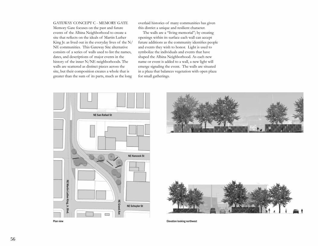
56
GATEWAY CONCEPT C - MEMORY GATEMemory Gate focuses on the past and future events of the Albina Neighborhood to create a site that refl ects on the ideals of Martin Luther King Jr. as lived out in the everyday lives of the N/NE communities. This Gateway Site alternative consists of a series of walls used to list the names, dates, and descriptions of major events in the history of the inner N/NE neighborhoods. The walls are scattered as distinct pieces across the site, but their composition creates a whole that is greater than the sum of its parts, much as the long
Plan view Elevation looking northwest
Elevation looking at gathering space
overlaid histories of many communities has given this district a unique and resilient character.
The walls are a “living memorial”; by creating openings within its surface each wall can accept future additions as the community identifi es people and events they wish to honor. Light is used to symbolize the individuals and events that have shaped the Albina Neighborhood. As each new name or event is added to a wall, a new light will emerge signaling the event. The walls are situated in a plaza that balances vegetation with open plaza for small gatherings.
NE Martin Luther King, Jr. Blvd.
NE Hancock St
NE San Rafael St
NE Schuyler St
NE Grand Ave

57
MARKER CONCEPT A - LEAFLETSDespite their fl eeting nature, the posting of leafl ets as a form of urban communication has been used by countless communities in the exchange of neighborhood information. These Heritage Markers take the form of columns, 20 feet in
View at street level
height, placed one every three blocks on alternating sides of the street. Covered with permanent page size panels, “leafl ets”, carrying historical information these columns portray a variety of themes, stories and events important to the neighborhoods of inner N/NE Portland.
Possible leafl et locations
NE R
usse
ll St
NE Fr
emon
t St
NE S
kidm
ore S
t
NE A
lber
ta S
t
NE K
illin
gswo
rth S
t
NE A
insw
orth
St
NE R
osa P
arks
Way

58
MARKER CONCEPT B - STORY BENCHThis series of Heritage Markers relies on historical images along the boulevard to create a pictorial story of the rich history and diverse communities of the inner north/northeast Portland neighborhoods. Taking the form of horizontal benches, these “story benches” are located
frequently and randomly along either side of the boulevard as space allows. At night, these lighted Heritage Markers create bars of graphics seen both by vehicles and pedestrians moving along Martin Luther King, Jr. Boulevard.
Possible story bench locations
View at street level View of bench in evening
NE R
usse
ll St
NE Fr
emon
t St
NE S
kidm
ore S
t
NE A
lber
ta S
t
NE K
illin
gswo
rth S
t
NE A
insw
orth
St
NE R
osa P
arks
Way

59
MARKER CONCEPT C - CHANGING ICONSLocated at the primary intersections along Martin Luther King, Jr. Boulevard, these Heritage Markers are larger in scale and highlight streets that connect communities on the boulevard to the greater city east and west. The shape of these Heritage Markers alters slightly at each location, providing
View at street level
Possible icon locations
NE R
usse
ll St
NE Fr
emon
t St
NE S
kidm
ore S
t
NE A
lber
ta S
t
NE K
illin
gswo
rth S
t
NE A
insw
orth
St
NE R
osa P
arks
Way
unique way-fi nding sculptures that also carry themes and stories of historical signifi cance to the north/northeast Portland neighborhoods.

60
Appendix C
PUBLIC COMMENT
Public input was collected throughout the planning process through comment cards, website entries, and participation at public events. Do to the extent of comments submitted the following entries represent a summary of all comments received.
Public Open House #1
Comment Cards
Question #1: What do you think is the most important theme to be refl ected along NE Martin Luther King, Jr. Blvd.?
Melding of neighborhoods over time, not only • refl ecting the last 40 years.
Introduction of a gateway into the neighborhood • encompassing peace and harmony.
Diversity, cultural understanding• History• Historical timeline; signifi cant fi rst events •
regarding cultureDiversity and pedestrian amenities because it is a •
major road through the neighborhood area.Lights, archway, walking markers, old photos, •
story tellers.Neighborhood history.• Color and diversity. Be sure to check the reports •
from the Soul of Portland marketing project. Their outreach was very effective.
Question #2: Are there areas along the boulevard that hold particular historical or cultural signifi cance for the community?
Volga Germans churches and historical business • that existed here from 1880-1960
Gladys McCoy Park, signifi cant neighborhood • historical presence acknowledged.
African American experience; buildings that are • on the street and in neighborhoods.
Eliot neighborhood, an area that still holds a • few special places that are unique in the black experience.
Martin Luther King, Jr. Blvd. and Rosa Parks • intersection; main intersections are interesting.
The center of the blvd. Re-do the trolley• Contact and get ideas from Roslyn Hill and •
Adrianne Cruz
Question #3: What would you like to see included in the Gateway project:
A full refl ection and history of the neighborhoods • not only the last 40 years
Continuous structural monuments that grow • upward versus banners or ground markers.
Walking tour of historical value and cultural • peace and tolerance. Overhead and under foot directional aids.
Maps• As much historical and guidance for visitors and •
citizens.Love the old downtown 3rd Street arches. Put •
something on the West side of the gateway triangle.
Lights! Bright! Being able to see from one marker • to the next.
Use color! Metal materials. Lots of design • elements. More is more. Have a design charrette.
Question #4: What does “Heritage Marker” mean to you? To your community?
Retrospective appreciation of heritage-pride.• “Heritage Markers” that identify the historical use •
of an area, people, businesses etc. that have been in this area.
Knowledge for visitors and youth.• An educational tool for both youth and visitors.• I like the idea of markers on buildings. Something •
like the East Bank Esplanade. Make them visible from the street. Unique to the area.
Remove the median and put in light rail or the • trolley down the middle of the street or build out major curb bumps and islands.
Question #5: Additional Comments
Before Martin Luther King, Jr. Blvd. was Union • Ave. There’s a huge history there.
Please maximize opportunities to educate future • generations about the contributions of the many people that have lived and worked here.
Each neighborhood should have signage to • introduce visitors to interesting projects.
I like the idea of working with business owners • and students. Give attention to individual neighborhoods. Love the way fi nding idea
Bring in color with City Repair intersections• Clear out the overgrown unfriendly bushes and •
have something more inviting and manicured (like the park area across from Bridges Cafe)
Fund it soon! Don’t let it sit to do this again in • ten years.
Talk occurred for fi ve years last time and all the • money was spent before actually implementing any gateway development
The marketing of materials (of the Soul of • Portland) were terrifi c but temporary. Build the hardscape fi rst. Fund whatever is designed within two years while the ideas are still fresh.
Discussion period
Do not close off nearby connector streets that • people use to access the neighborhoods. That would force more traffi c on to Martin Luther King, Jr. Boulevard
Maintain the pedestrian connection at the site.•

61
Consider “way markers” with continuity for • pedestrians, especially visitors coming from the Convention Center.
Make sure businesses on Martin Luther King, Jr. • Blvd. are on the SAG.
The area currently is not bike or pedestrian • friendly. Can improvements be incorporated with this project?
Is there a budget? Where did the funds come • from? How much is available to implement this project?
Who is the design team? Who do they work for?• What is the decision-making process? Who •
makes the fi nal decision?Is the city looking at placing heritage markers in •
other parts of the city?
Public Open House #2
Small Group Work Sessions
Related to Content:
Broad History: Refl ect the fullest breadth of • history; include diversity of all communities over time
Multiple Audiences: Should be for both tourists • (interest/education/way-fi nding) and residents (pride/ education/landmark)
Timeframe: Address future as well as past• Gateway: Acknowledge neighborhoods; •
secondary layer reference Dr. Martin Luther King, Jr.
Heritage Markers: Primarily historical content; • current neighborhoods as secondary layer
Related to Function:
Heritage Markers should be an educational tool • for visitors and residents
Way-fi nding: Heritage Markers should serve as a • way-fi nding device
Primarily Pass-By: vehicular, pedestrian, but not • for community gathering
Interactive: Changing or adding information, • interactive, ability to access additional information
Related to Characteristics:
Visibility: Should see Gateway Site elements • from afar, see from one Heritage Marker to another; incorporate lighting
Durability: Elements must age well, consider • maintenance and durability
Physical Characteristics: Columns for impact with • walls for content; balance green and plaza
Related to Process:
Implementation: Project should be of high • quality, not allowed to languish, continued public involvement
Comment Card Summary
Gateway Concepts
1. Which gateway concept best creates a feeling of entering a unique set of neighborhoods?
Combine concepts A and C. Remove the fairy • lights in A because of maintenance issues
The Memory Gate goes through what is a clear • transition point. Walls stop the eye and form a passage
Memory Gate but no reason why the “stars” • (from concept A) over the roadway couldn’t be included as it will do a better job at night marking the gate
One that represents the diverse ethnic • background of the Albina neighborhood
Gateway concept C, the Memory Gate, feels • the best because it’s a better way to refl ect
the history about the many people past and present in the neighborhood
North Star concept is my choice• I like the lights from A, the phrase from B( Life •
begins to end) and the gathering space from CCombine A and C and remove fi refl y lights. No •
to B. Put lights in both towers (concept A ) as it will create a connection between both ends of the gateway
I liked elements of each concept. The height • of the North Star concept provides good visibility form north and south and the convention center. Trees are good to add and the open block wall is good as well. Combine A and C. The towers are important
All of the concepts work but North Star and • the Wall concepts are dramatic. Movement is primary and community information secondary. Be sure to have a maintenance plan
2. Should the Gateway Concept include places for individuals and communities to gather or should it be a place you experience while passing by?
Wall information for tourists, conference goers • from convention center
Defi nitely experience in passing. It’s not a great • space for gathering; there’s lots of traffi c and the space is small. It’s at the lower boundary where there isn’t too much concentration of people to gather. Not friendly for gathering
Too much traffi c and too little room for • “gathering” Also don’t want to create a “camping” space for homeless or drug user. Space should be very open to outside eye
Diffi cult place for people to gather given the • traffi c/noise/pollution unless the traffi c is limited
Most defi nitely. It seems that the area was one of • Portland’s fi rst places for people who settled early on to gather. Only by experiencing it will it be understood

62
This is a pass through site• This is a site to experience passing by• This should be a gathering space. But as it is, no •
one wants to sit on Martin Luther King, Jr. Blvd. with traffi c, noise and odors. If benches and trees were added and traffi c modifi cations made, it would make it easier to sit and chat at the location.
Consider community bulletin boards, more trees • and use of solar power
Both, but mostly a pass through site• This is not a gathering space. Maintain a balance •
of greenery and plaza
Heritage Markers
3. One of the goals of the Heritage Markers is to tell the history and stories of the surrounding neighborhoods. How can that history best be told?
Abstract markers that differ will assist in locating • area neighborhoods; high visibility
Entire history (from Albina to current day) • should be told, include people events and place especially links to historic locations and remaining places
Like the concept of portraying local heroes (past • and present) to tell a broader story of an ethnic group
Yes, all these examples are great. Should be • inclusive to all ages
I don’t like the bench. I prefer the leafl et concept. • Perhaps it would be possible to incorporate changing icons at major intersections
Should be places of historical signifi cance• All three ideas. Walking tours, gathering spaces, •
geographic sites. Many of us are hungry for history and don’t have access to the stories. Make it easy to learn our history
Flexible so that the content of the markers can • be swapped out
Columns are best. Scale of changing object•
4. Should the Historic Markers focus on identifying current neighborhood boundaries or on displaying historical information?
Yes, both (change information each year on • Martin Luther King, Jr. Blvd.Birthday Holiday)
Historical information• Not an either or choice. Memory gate concept •
should list neighborhood names to link with markers along the street.
Historical information should be the focus• The history is signifi cant to the boundaries •
of how they seem to have developed the neighborhood.
Historical information as it better represents the • variety of populations that live and have lived in the neighborhood.
Display historical information• Both but identify neighborhoods “loosely” ( i.e. •
a sign in the middle of the area, not indicating specifi c borders as this could be divisive)
Concentrate on historical information but tell • people what neighborhood they are in
Both but don’t mark the neighborhood • boundaries because they may change
Both are good. Allow for changing information.•
5. Additional Comments?
Nice project. Would be a good use of that odd • little space
Include old/new neighbors names and history • because communities of color seem to be left out. I feel African Americans settled here and were held to this area for so long
Please approach Albina Community Bank about • an ongoing maintenance agreement. A sign giving them credit would be nice
Be careful about using too much metal in the • project
Martin Luther King, Jr. already has a space. This • project should be about the neighborhoods
and Portland folksThe street is named for Martin Luther King, Jr. •
What more honors does he need? Did he ever visit Portland?
I think the trend is moving toward making Martin • Luther King, Jr. Blvd. a pedestrian, biking public transportation boulevard rather than a trucking/drag strip throughway
Public Open House #3
Summary of Public Comment on the Mapping of Neighborhood People and Places
1.This list of historic people, places and events is no doubt incomplete. Are there additional ones that should be explored?
Vessels; homeware specialty store featuring ethnic • homeware. NE Martin Luther King, Jr. Blvd and NE Martin Luther King, Jr. Blvd and Morris. Owned by Phyllis Gaines
Albina Homestead School; Germans attended • to learn English (photos available). Near Fremont
#33 was originally Dr. Uhle’s offi ce• #17 – date is 1986• #51 – address is 2125 N. Vancouver Ave• James Brooks; resident, was president of the •
Urban League. Residence on NE 11th between Knott and Brazee
Raven Creamery; NE Martin Luther King, Jr. • Blvd 2 blocks south of Fremont
Zion Lutheran Church and School; was located at • Rodney and Ivy, is now Morning Star Baptist
Rosyln Hill’s fi rst gallery; off NE Martin Luther • King, Jr. Blvd and Thompson
Morning Star Church; Rodney and Ivy• Steen’s Coffee Shop; owned by Ron Steen, •
located at NE Martin Luther King, Jr. Blvd and Russell
Native Americans and other immigrants•

63
The “old” Fred Meyer; NE Martin Luther King, • Jr. Blvd and Killingsworth, was a community meeting place
Pharmacy, Dry Cleaner, Cafe; Williams and • Russell near the Urban League Building. Gathering place for African American community 1950’s and 60’s. This area included well known businesses such as Paul’s Paradise, Lou’s Men Shop, the Flamingo. Demolished in the 1970’s during the expansion of Emmanuel Hospital
Additional Comments
1. Related to the Gateway Site
Don’t close any of the streets including the small • turn back. These streets are part of the area’s history and are known by area residents. You can’t manipulate history or change history to tell about history. You must respect the existing patterns.
Look at ways to reduce speed of drivers headed • north on NE Grand through the s-curve. Numerous wrecks occur at the corner of the Albina Bank.
Use materials that are durable and vandal resistant• With regard to ongoing maintenance team •
with the Albina Corner Apartments Reach Volunteer Program.
Consider improving adjacent sidewalks • surrounding Gateway site. On sidewalks where the spur leaves Grand and continues straight there are no curb cuts and you must enter the roadway to continue. This needs to be part of the improvement of the site.
2. Related to Heritage Markers
Sidewalk markers seem like a durable idea.• Like the combination of two types – one makes •
bigger impact on street and cars, the other good for walkers

64
Appendix D
MEETING NOTES
Stakeholder Advisory Group
Project:
Date: Time:
Martin Luther King, Jr. BlvdGateway and Heritage Markers Concept Master Plan10.16.075:30 – 7:00 pm
Subject: Location:
Stakeholder Advisory Group #1Irvington Village Covenant
By: Melinda GrahamAttendees: Paul Knauls Sr., Citizen-At-
Large; Daina Hamer , MLK Advisory; Sam Morgan, PCC; Gloria McMurtry, NNEBA Irene Bowers, PDC; Sara King, PDC; Joanne Daunt, PDC; Joleen Jensen-Classen, PDC; Jonathan Beaver, 2.ink Studio; Melinda Graham, 2.ink Studio; Janice Dilg, Consulting Historian; Harold Williams Sr., CH2A; Harold Williams Two, CH2A; James Harrison, James M. Harrison Art & Design Studio
WELCOME/INTROS/INITIAL THOUGHTSIrene Bowers welcomed the group and opened introductions with the question, “what do you think of when you hear the word Gateway”. Core themes brought forward by the group included:
Gateway as denoting a transition from one thing • to another, a shift in how you perceive a place.
Images of entry, arrival, a literal gateway or arch • such as the one marking Portland’s China Town District that denotes passing through and into a distinct neighborhood.
A structure, physical element, but needs to be •
“universal”, capable of celebrating the “stop-over” nature the neighborhood has had for many diverse communities all capable of, and rising to, the ideals that Martin Luther King Jr. put forward for everyone.
A symbol when we fi rst come in, a chance to tell • local stories using a National character that symbolizes commonality. The gateway and markers as a beginning to defi ning a unique district where communities have persevered, have shared trials and tribulations but also celebrations.
Themes of movement seen both literally, in the • movement of the street, traffi c, pedestrians, but also fi guratively in the migration of people and communities throughout the history of the area.
Gateway as a powerful and hopeful symbol for • the community, creation of a “living gateway” that people can be a part of, one that reaches into the past but also reaches into the future as a contemporary, optimistic symbol of what the neighborhood has been as well as what it hopes to become
Gateway as a portal, passage, transcendence to a • higher awareness.
Opportunity for public art to be brought to the • community rather than asking the community to seek out art. Use of art as a poetic way to relay ideas
Gateway as a time based piece, a landmark • representing the face of this community, a space changing over time.
Ongoing change at the gateway site could serve • as a way of building awareness, a sense of anticipation in what may come next (similar to the affect of RACC’s In Situ program)
PROJECT BACKGROUNDThe extent of the primary gateway site was reviewed. The slight expansion of the site to include the small parcel of land immediately
north of the WelPland Building was noted. PDC will provide the Design Team with property line information. The physical nature of the site was also discussed, noting the extensive overhead utilities and traffi c signage that is likely to remain. While the alignment of the primary travel lanes of Grand and Martin Luther King Jr. Blvd are seen as “givens”, the group discussed the potential for modest improvement of the surrounding secondary streets, NE Schulyer St. and NE Hancock St., to improve the pedestrian environment and connect the site to the surrounding neighborhood context.
The extension of Heritage Markers north along the boulevard was also discussed with Portland Blvd noted as the northern extent currently under consideration. The nature and location of the markers is still to be determined and will be a product of the design and public process. SAG members encouraged the Design Team to give equal consideration to the Markers while developing the Gateway site.
GOALS AND OBJECTIVESThe Design Team reviewed the preliminary goals put forth in the RFP. These initial goals have been developed through previous planning efforts such as The Albina Community Plan, The Eliot Neighborhood Plan, The N.E. Martin Luther King, Jr. Transportation Project, and The Martin Luther King, Jr. Boulevard Strategy Update and Action Plan. Preliminary goals include:
Creation of a gateway to the N/NE Portland • communities announcing arrival into a distinct district with a rich and diverse heritage
Commemorate the life and ideals of Dr. Martin • Luther King, Jr.
Create a series of Markers that capture the • history, stories, and character of the communities connected by Martin Luther King, Jr. Boulevard

65
Enhance the pedestrian environment and • build continuity along the boulevard while celebrating the distinct neighborhoods linked by the street.
These preliminary goals will be reviewed and refi ned during the public process for the Gateway and Heritage Marker project.
PUBLIC PROCESSThe public process will include on-going SAG meetings and a series of three Public Open House events to seek input and guidance from the community. In addition, the Design Team will conduct individual and small group interviews to collect specifi c stories from the neighborhoods. A mentorship component is also underway to involve area youth through job shadowing and participation in project events. The intent of the public process is to engage the greatest breadth of the community possible. The SAG was encouraged to consider community members appropriate for the Design Team to contact regarding neighborhood histories and personal stories. SAG members were encouraged to contact Irene Bowers directly.
DESIGN PROCESSThe iterative nature of the design process was emphasized. Design phases will include the collection of site data and community stories, the generation of unique design alternatives and the fi nal refi nement of one conceptual master plan scheme. The SAG team emphasized the importance of staying open to all ideas in the early phase to ensure the team’s ability to fully explore all opportunities.
END
Project:
Date:Time:
Martin Luther King, Jr. BlvdGateway and Heritage Markers Concept Plan11.08.075:30 – 7:00 pm
Subject:Location:
Stakeholder Advisory Group #2Irvington Village Covenant
By: Melinda GrahamAttendees: Paul Knauls Sr., Citizen-At-
Large; Daina Hamer , MLK Advisory; Eric Wentland, Business Owner; Gloria McMurtry, NNEBA; Allen Folz, Piedmont Neighborhood; John Tyler, Vanport PAC; Teri Karren-Keith, Albina Community Bank Irene Bowers, PDC; Joanne Daunt, PDC; Joleen Jensen-Classen, PDC; Jonathan Beaver, 2.ink Studio; Melinda Graham, 2.ink Studio; Janice Dilg, Consulting Historian; James Harrison, James M. Harrison Art & Design Studio; Paul Mort, the Felt Hat
WELCOME/INTRODUCTIONSJolene Jensen-Classen welcomed the group and led introductions for new SAG members joining the process. Irene Bowers updated the Advisory Group regarding the withdrawal of CH2A from the process due to confl icts with work previously committed to by the fi rm. Team members noted their gratitude for the efforts and feedback already contributed by both Mr. Williams Sr. and Mr. Williams Two.
OPEN HOUSE LOGISTICSIdeas regarding venues, date and format for the Public Open House were solicited from the SAG.Venues suggested:
Meeting space at the Lutheran Church •
Albina Bank Reception room• Portland Community College cafeteria and • auditorium
Date:The 1st or 2nd week of December was considered but the SAG felt it best to postpone the fi rst Public Open House until after the holiday season to avoid competing events and allow time to publicize.
Format:Commemorate the life and ideals of Dr. Martin •
Luther King, Jr.Staging the Open House on a weekend •
afternoon with time slots assigned to specifi c Neighborhoods for comment
Inclusion of a social time prior to the formal • presentations to “get to know folks”
In general it was felt that giving people something • concrete to respond to as well as tailoring the Open House dependent on the materials to be presented were important considerations.
Announcement:The SAG considered ways for “getting the word out” including via their own neighborhood email networks, through the Neighborhood Associations, by asking local businesses to display announcements, and involving local news sources to announce the event. The Committee noted the importance of people feeling they have had the chance to truly contribute. It was felt that six months seemed short for a project of such importance, but PDC and the Design Team noted that they are committed to doing what it takes to get the process right, thus the extension of the schedule.
PRELIMINARY OPEN HOUSE CONTENTThe Design Team presented a preview of their work to date, noting that the team was still in the “information gathering/brainstorming phase”.

66
Current work has been focused in three primary areas; community history and stories, studying the evolution of how people use monuments to mark events, and understanding the specifi c physical characteristics of the project site.
History: Jan Dilg presented a brief overview of the approach to historical data collected. Her presentation focused on approaches to understanding and organizing diverse histories: thematic, chronological, events/eras and biographical. As an example, impacts of the Albina Railyard as related to migration and commerce where discussed, noting how this laid the foundation for establishment of a strong African American community that later formed the basis of Portland’s Civil Rights Movement. The presentation closed with a request for input as to the best sources for understanding local players and impacts of the Civil Rights Movement.
Monuments: James Harrison then presented a discussion of the Evolution of Monuments, illustrating historical efforts to commemorate individuals and events through the creation of physical space and forms. Specifi c examples related to Martin Luther King, Jr. and the Civil Rights Movement were also reviewed. This discussion closed with questions such as, “what will resonate in Portland”, “what makes our story unique and specifi c to place”, “how do we want this monument to function”?
Site: Jonathan Beaver reviewed physical characteristics of the site as they relate to the implementation of both markers and the gateway concept. He noted the high degree of visual elements already present on the boulevard as well as illustrating the restricted sight lines present. The legibility of markers from both the vehicular and pedestrian perspective was reviewed noting the general frequency and scale required to achieve a sense on continuity along the street. Characteristics of the gateway site were also discussed including the challenges of existing
utilities, signage and adjacent traffi c volumes that are likely to remain. Opportunities for extending the impact of the gateway site into adjacent secondary streets were also discussed.
SAG FEEDBACK“What happened since the 1970s photo”? – •
The group discussed the sense of vibrancy, traffi c, and people in the photo, expressing that it seems that “sense of life” seems more subdued now.
Is “continuity” necessarily needed or good – • perhaps there is something of greater value in the diversity of the streetscape. Concern that a focus on “cohesiveness” doesn’t move the street toward vibrancy.
The unique quality of the area has to do with • the number of different communities that have called it home; Italians (“Albeena” not Albina), Scandinavians, Germans, Russians, Irish, Blacks, etc. The interest is in why people came and how places shifted with the interests of immigrant groups and how they used the buildings and the spaces.
Focus should be on the 120 year history of • immigrants in transition
Consider that the gateway site is an entrance but • also an exit
How can you make an impact given visual • competition, autocentric nature.
Is street one long strip of several segments • (Broadway-Fremont, Fremont-Alberta,Alberta-Ainsworth, Ainsworth-Rosa Parks and past)
The understanding of monuments should not be • restricted to just built structures; Central Park is a monument.
The historical review of monuments is good, • engaging, but moved too quickly to a focus on Civil Rights memorials. Why the shift in focus? (PDC response – building on the origin of the idea to commemorate Dr. Martin Luther King,
Jr. as noted in the Albina Community Plan)The overview of the presentation did not feel •
like an “invitation to give feedback”. Need to be clear on intent; to build enthusiasm for something or to encourage getting involved, which is the focus.
Open House must provide a means to respond • afterward or engage during the discussion.
NEXT STEPSClosing discussion focused on the need for clarifi cation of the project and associated presentation approach – is it a history of the boulevard or of the Civil Rights movementMembers suggested moving the Public Open House to January with an additional SAG Meeting scheduled prior to further refi ne project approach and discuss associated presentation materials. The SAG emphasized the necessity to allow suffi cient time to build interest while also avoiding the extended holiday season
The SAG was encouraged to think of additional community members that should be involved in ongoing conversations and to pass those names along to Irene. Irene Bowers will contact members to establish a subsequent date and time for SAG Meeting #3 following the holiday season.
END
Project: Martin Luther King, Jr. BlvdGateway and Heritage MarkersConcept Plan
Date:Time:Location:Subject:
01.15.08 5:30 – 7:00 pmIrvington Village CovenantStakeholder Advisory Group #3
By: Melinda Graham

67
Attendees: Paul Knauls Sr., Citizen-At-Large; Daina Hamer, MLK Advisory; Eric Wentland, Property Owner; Gloria McMurtry, NNEBA; Allen Folz, Piedmont Neighborhood Assoc.; John Tyler, Vanport PAC; Teri Karren-Keith, Albina Community Bank; Pauline Bradford, Eliot Neighborhood Assoc.; Sam Morgan, PCC Art Department; Sam Jackson Sr., Citizen-At-Large; Irene Bowers, PDC; Joanne Daunt, PDC; Joleen Jensen-Classen, PDC; Jonathan Beaver, 2.ink Studio; Melinda Graham, 2.ink Studio; Travis Scrivner, 2.ink Studio,; Janice Dilg, Consulting Historian; James Harrison, James M. Harrison Art & Design Studio
WELCOME/PROJECT UPDATEFollowing an opening welcome by Joleen Jensen-Classen, Irene Bowers updated the Advisory Group regarding the Design Team’s ongoing work:
The project and open house announcement • fl yers have been completed and distribution to businesses along the boulevard is underway.
The team continues to work with Troy Hollis • at SEI and Daniel Capuia at Jefferson High School to involve area youth in the project.
The fi rst Public Open House event has been • scheduled for Tuesday, January 22nd at OAME (3413 N. Vancouver)
PROJECT GOALSIrene Bowers reviewed the overall project goals:
Involve a diversity of stakeholders in the process.• Create a site that honors the ideals of Dr. Martin •
Luther King, Jr.Redevelop the site as a gateway into the •
Northeast Portland neighborhoods. Implement Heritage Markers at key intersections •
along Martin Luther King, Jr. Boulevard.
REVIEW OF UPDATED OPEN HOUSE CONTENTMelinda Graham summarized the Advisory Group’s prior feedback on the draft Open House presentation as follows:
Clarify the impetus and goals of the project to • provide context for the presentation. What is the intent of the project?
Keep the overview of history broad and inclusive • of the many diverse communities that have lived in and around the project site.
Broaden the discussion of “monuments” to • the greatest extent possible to consider wide variety of ideas
Consider the distinct neighborhood boundaries • as well as the location of strong east-west connector streets in discussing the intent and location of potential markers.
The Design Team then presented the updated Open House presentation, reviewed the proposed Open House agenda/format and once again opened up the discussion to the SAG for feedback.
SAG FEEDBACKTeam needs to also consider areas around the •
gateway site. Explore the possibility of removing the turn-back lane.
In creating a “Gateway into Northeast” we need • to answer the question “a gateway into what”; series of unique neighborhoods, distinct business district, what?
Markers could be like those in Boston that tell •
people about the history. We need to keep track of this history. Pauline - Mt. Olvin, Elks Club (colored YWCA), Emmaculate Heart
Recognize that there have been different groups • in different times making these places their own but that the experience of the African American community is unique in that this group was forced to one area by the Vanport fl oods and then kept there by policies such as red-lining that did not allow them to move out into other city neighborhoods.
It is a gateway to the “communities” of • Northeast Portland. Do not make it singular (“community”) because this does not recognize the distinct differences that are what actually makes it an interesting area. Perhaps it is a gateway to a “corridor”
In response to Irene Bowers query of “what questions should we ask”?
Ask how to defi ne the problem – is it a gateway • to what? Then ask what direction to take – history, civil rights, neighborhoods, signifi cant events on the street....Ask if it is a corridor, a gateway, a memorial.
Also need to ask what history we are looking at. • How do we defi ne history?
Consider the use of the term “gateway” – does • this lead people in only one direction; is there something more broad?
Eliminate the idea of the street or boulevard • from the questions – this is about the neighborhoods. Recognize that the street is secondary and that the communities are most important.
This is the fi rst Public Open House. Be conscious • of what are too leading of question....”how are Martin Luther King Jr.’s ideals refl ected in the street”, use of the words like “soul of street”. Keep it as open as possible.
Use “commemorate” rather than memorial•

68
This is the fi rst Public Open House so clarify • what things are pretty set such as ideas of “markers”, “gateway” and then keep it open...ask what would you like to see?
State the givens more clearly and return to basics: • What does a gateway mean to you....what, to where?
Include a board for the Open House that states • the basis of the project, shows the extent of the Albina Community Plan efforts and also shows the Gateway project extent. Be clear that the project currently goes to Rosa Parks Blvd. because this is the edge of the OCC Urban Renewal Area. Does not mean that the efforts may some day extend further.
But also consider how this project connects with • other projects (convention center, etc)
Site commemorating Dr. King (not memorialize), • ask what does gateway mean to you. Clarify assumptions and the re-ask the questions.
This project needs to help new comers • understand that the African American community has been here and has a long deep history here – need to fi nd ways to focus on questions that pull that out.
Break assumptions into Givens and Things that • need to be reaffi rmed. Once Assumptions are established, ask how would YOU do it, what do YOU picture.
NEXT STEPSReview of the Open House format and methods •
for feedback that will be available.Need a fi rst (additional) meeting or email update •
to SAG regarding feedback on Open House event. Issue this information as well as new information prior to the next SAG meeting to allow for initial comment period (prior to the SAG meeting).
Followed by a 2• nd meeting to review ongoing work of the Design Team prior to the Public Open House #2
Irene Bowers will contact members to establish a • subsequent date and time for SAG Meeting #4 following the fi rst Public Open House event.
END
Project:
Date:Time:
Martin Luther King, Jr. BlvdGateway and Heritage Markers Concept Plan02.20.085:30 – 7:00 pm
Subject:Location:
Stakeholder Advisory Group #4Irvington Village Covenant
By: Melinda GrahamAttendees: Paul Knauls Sr., Citizen-At-
Large; Daina Hamer , MLK Advisory; Eric Wentland, Business Owner; Gloria McMurtry, NNEBA; Allen Folz, Piedmont Neighborhood; John Tyler, Vanport PAC; Teri Karren-Keith, Albina Community Bank; Pauline Bradford, Eliot Neighborhood; Sam Morgan, PCC Art; Sam Jackson Sr., Citizen-At-Large; Irene Bowers, PDC; Joanne Daunt, PDC; Joleen Jensen-Classen, PDC; Jonathan Beaver, 2.ink Studio; Melinda Graham, 2.ink Studio; Travis Scrivner, 2.ink Studio; Janice Dilg, Consulting Historian; James Harrison, James M. Harrison Art & Design Studio
WELCOME/INTRODUCTIONSJoleen Jensen-Classen welcomed the group and led introductions for the benefi t of new participants at the meeting. Joining the regular group were Marquis Stoudamire, Citizen-At-Large and Daniel
Capuias, the team’s mentorship coordinator from Jefferson High School.
Irene Bowers updated the Advisory Group regarding the Design Team’s ongoing work:
The Public Open House #1 was held January 22 • at OAME headquarters
Team has met with the Technical Advisory group• The date, time and venue has been set for Public •
Open House #2 and is Saturday, March 8, 10 a.m. to noon, at OAME
CONCEPT ALTERNATIVESMelinda Graham reviewed the overall project goals:
Redevelop the site as a gateway into the • Northeast Portland neighborhoods.
Create a site that honors the ideals of Dr. Martin • Luther King, Jr.
Implement Heritage Markers at key intersections • along Martin Luther King, Jr. Boulevard.
Involve a diversity of stakeholders in the process.•
The team’s recent work has focused on developing Concept ideas for both the gateway site and the historical markers that meet the stated project goals and giving form to and testing the concepts
The Design Team then presented the Concept Alternatives as developed to date for the Open House #2 presentation, reviewed the proposed Open House agenda/format and once again opened up the discussion to the SAG for feedback.
SAG FEEDBACK
Is there too much “greenery” in some of • the schemes – what if it creates too much seclusion that attracts the homeless?
Response from other SAG member: Don’t • make the schemes inhumane just to prevent the homeless from coming. You have to ask yourself what would Martin Luther King, Jr.’s

69
response be? Make it inviting for the whole community to take pride in.
Think about more lighting for all of the concepts • needs to be a bigger part of the concept
Closing Hancock at the Gateway site would • eliminate parking immediately adjacent but would create a more pedestrian friendly environment. People can walk or bike to the site as well.
There is only limited use of Hancock right now; • the majority of folks enter Irvington along Grand.
It would be a small concession to Dr. King to • close a small piece of road so that people can experience something special. The majority of people may initially experience it from the vehicle but if you can draw them in then the next time they may stop and stay to experience the entire space.
This is not a place of solitude though with all of • the traffi c coming to and from work.
Evenings and weekends are calmer though so • maybe there are different experiences at different layers.
The original idea put the primary emphasis on • the vehicular; create something to announce that you are entering the northern part of Portland, a unique area. So it needs to be something big to capture this idea.
The other piece was history as a second layer, or • maybe one that sends you on to the next piece like direction markers sending you to different places within the area.
In response to Irene’s question regarding PDC’s assumption that the site should be a commemoration to Dr. King:
This is why the focus on “ideals” works so well. • It takes the words and ideals of Dr. King and shows how different communities have struggled for equality and justice by telling the
historic stories of these neighborhoods.Dr. King can be referenced and the site and then •
his ideas refl ected in the stories as you move down the street and see the markers.
This is why it needs to be broader, it needs to • recognize other communities both prior to Dr. King and after that have shared in the same struggles and dreams.
So if there is the gateway done in a way the is • recognized regardless of speed (arch you go under by day, lit up by night) but then there is another layer, more pedestrian, more refl ective layer that references these ideas on the site.
When we think of gateway then it is an area • you can move around in; this could be an important place to create a space to refl ect, pay respect before moving forward along the boulevard.
With regard to the site analysis:
Need to ask if you are experiencing these things • by car or on foot and the answer is both.
You need to consider where people will be • looking and make it as visible as possible.
Need to consider that there is the statue of Dr. • King at the Convention Center – how do I get to Martin Luther King, Jr. Blvd and continue to explore that legacy.
What about a 5-10’ translucent wall with prints/• silhouettes that can work both day and night.
This has been a neighborhood of immigrants – • this is where the story is.
People have long histories here and most kids • don’t know about past people.
With regard to funding and implementation:
What worries me most is that there is no funding, • no maintenance. We need a reality check. So much design work ends up being totally different for funding and maintenance reasons.
But at least now there is momentum and there are • other developing pushes.
(Irene) We understand the hurdles and right • now we have ½ million for construction but ongoing maintenance is still a big question.
We are looking at the Business Improvement • District (BID) taxed for maintenance – the community has to vote on that.
(SAG) We need to build identity of the • neighborhoods into it so that neighborhoods will want to pitch in sponsorship.
END
Project: Martin Luther King, Jr. BlvdGateway and Heritage MarkersConcept Plan
Date:Time:Location:Subject:
05.13.08 5:30 – 7:00 pmIrvington Village CovenantStakeholder Advisory Group #5
By: Melinda GrahamAttendees: Gloria McMurtry, NNEBA; John
Tyler, Vanport PAC; Teri Karren-Keith, Albina Community Bank; Steve Lebwohl, Wildwood; Irene Bowers, PDC; Joanne Daunt, PDC; Sara King, PDC; Jonathan Beaver, 2.ink Studio; Melinda Graham, 2.ink Studio; Janice Dilg, Consulting Historian; James Harrison, James M. Harrison Art & Design Studio
WELCOME/INTRODUCTIONSSara King offered a brief welcome to the group, thanking the SAG members and the Design Team for their continued efforts on the project. Irene Bowers updated the Advisory Group regarding the Design Team’s ongoing work:

70
Public Open House #2 was held March 8, 2008 • at OAME headquarters. Participants engaged in lively round table discussions regarding three gateway and three historic marker options – see handout for summary of public comment.
The Design Team and SAG members also • recently participated in a work session with Craig Barton, a visiting professor from UVA, who emphasized the importance of keeping the project focused on local events and stories, “making it of this place”.
The date, time and venue has been set for the • fi nal Public Open House and is as follows: Wednesday May 28, 6 p.m. – 8 p.m. Irvington Village Covenant, Meeting Room
The next hurdle for the project continues to be • developing a strategy for maintenance and upkeep of the project elements.
A brief discussion of how to facilitate the public’s awareness and understanding of the project in the next phase produced the following suggestions:
Hold an informal public open house/gathering • at the adjacent Albina Bank so visitors have the opportunity to hear background on the project and then participate in one of a series of small group tours of the gateway site itself. This may help the general public better understand the proposed concept master plan.
Create a modest mockup of the heritage marker • concept for display at area businesses.
DESIGN REFINEMENTSJonathan Beaver reviewed the refi nement work for both the Heritage Markers and the Gateway site:
To bring graphic form to the historical • information collected to date, the Design Team is working to assemble a “history
map” which illustrates examples of people, places and events identifi ed through the design and community process to date. This mapping exercise highlighted the opportunity for creation of a secondary layer of modest markers, perhaps inlaid in the sidewalks that could provide general direction (west 3 blocks) to points of historical interest that lie off the boulevard proper. The larger pictorial markers on the boulevard would focus on capturing historic themes, for example commerce, that have played prominent roles in the development of area communities. These markers would be more rhythmic in their placement and lit from within at night.
Refi nement of the Gateway Site, based on • input from the second Public Open House workshop exercises, was also presented. The current site plan incorporates a sculptural “beacon” situated in a modest plaza. A grove of trees shades portions of the plaza with adjacent walls providing opportunities for incorporating pedestrian scale text relating historical information. An landform frames the boulevard as it moves through the site.
SAG FEEDBACKMapping Historical Data/Heritage Markers:
With regard to the items currently being • “mapped”, where did the information come from? Largely from Jan’s work, from community members at the Open House, or other sources?
The bulk of the information has come from the • historian’s work as a starting point with the community then weighing in and adding items at the Open House events, through word of mouth or via comment cards and the web. Some of Jan’s initial work put her in contact with individuals, such as members of the
Volga German Russian community, that then came to and participated in the Public Open House work sessions as a result.
Is the addition of lighting to the Historic • Markers part of the artistic expression or for illuminating the information?
Both; lighting the markers gives them a strong • visual night time presence, extends the hours in which they communicate both information and continuity along the street.
Like the black and white nature of the images – • how they convey a sense of history. Like the secondary markers that let additional places be denoted in a more modest way. Could make it easier to extend the system in the long run.
Take care with material selection so that theft of • the markers does not happen (pulling bronze inlays from walks, etc).
Gateway Site:
Are the lines on the plan showing an elevated • landform or a depression for gathering stormwater?
What is shown is an elevated landform intended • to emphasize the sense of passing through the site and entering a new district. The crown on the surrounding roads makes it diffi cult to draw surrounding stormwater to the site, although direct on-site stormwater will be handled within the gateway site itself.
The landforms seem to create a strong vehicular • experience. Is there an opportunity for a walking experience through the elevated pyramids as well?
Speaking with the Technical Advisory Group • eliminated the possibility of adding a sidewalk along the immediate outer edge of the boulevard as it moves north through the site due to concerns for pedestrian safety. The concept plan does integrate new pedestrian

71
Highway 99E was decommissioned many years • ago so the 99E traffi c signage could be removed.
This area falls under PDOT and all enhancements • would need to meet PDOT standards. The yellow and black traffi c arrows will likely need to be incorporated and matched to PDOT standards. Dan will work to get applicable information from the PDOT traffi c engineers.
What stormwater issues might be present on the site and what would trigger the need for stormwater treatment?
Development of greater than 500 SF of • impervious area on the site would trigger the need for stormwater treatment. Send topo to Dave Nunamaker to determine how water is currently fl owing adjacent to the site.
On site water lines may be covered with a limited • amount of fi ll
All utilities on the site are part of franchised • agreements. Irene to talk with Mary Beth Henry or Ben Walters regarding PPL Electric Utilities role.
Are there specifi c issues or criteria related to site lines that the team should account for?
If NE Hancock were closed it would alleviate • both current and future site line concerns by reducing the number of lanes feeding into the s curve. It would also open up greater opportunities for developing the gateway site as an entrance to the neighborhoods.
In addition to site lines, care should be taken • in developing anything that would be too distracting to drivers such as fl ashing lights.
What opportunities are there for improving pedestrian circulation?
access on the site’s west side across Grand. The question of plaza size and function were •
discussed at some length by the group. Finding a way to illustrate the approximate size of the proposed plaza space in the report was suggested. A need to balance intimacy versus the ability for a large group to gather was also considered. It was noted that the site is a noisy busy space. Ways of using the berm to screen this for the pedestrian was suggested.
How do we inform people passing in vehicles that • that there is something else there, that they should stop and visit/read information?
Technical Advisory Group
Project: Martin Luther King, Jr. BlvdGateway and Heritage MarkersConcept Plan
Date:Time:Location:
Subject:
02.08.08 2:00 – 4:00 pmPortland Development CommissionTechnical Advisory Group #1
By: Melinda GrahamAttendees: Dave Nunamaker, Bureau
of Environmental Services; Dan Layden, Portland Offi ce of Transportation; Liza Mickle, Portland Bureau of Planning; Susan Hjorten, Bureau of Environmental Services; Ivy Dunlap, Bureau of Environmental Services; Debbie Bischoff, Portland Planning Bureau; Irene Bowers, PDC; Joanne Daunt, PDC; Jonathan Beaver, 2.ink Studio; Melinda Graham, 2.ink Studio
WELCOME/INTRODUCTIONSIrene Bowers welcomed the group and began introductions. A brief project overview followed noting that the Design Team has completed the fi rst Public Open House event and is now beginning preparation of concept alternatives for the gateway site and heritage markers. Irene clarifi ed the Technical Advisory Group’s role as a sounding board for developing ideas with a specifi c emphasis on helping the team identify elements of the concepts that might be “deal breakers”, require specifi c permits or involve processes with specifi c time line requirements.
TECHNICAL OVERVIEW2.ink Studio provided a brief overview of the process and work completed to date. The team focused on completed site analysis work and then opened a discussion of technical questions:
What opportunities might be available to extend enhancements to include surrounding street areas (specialty paving, etc)?
There is the possibility of extending special • paving into Hancock however this is still a bit experimental regarding issues of maintenance. The Old Town Festival streets are serving as a working case study. The consent of adjacent property owners would also be needed.
There is the possibility of closing the small turn-• back lane between Grand and Martin Luther King Jr. Blvd as it carries very limited volumes, increases distractions on the high volume s curve and closure may have some inherent benefi ts from a traffi c perspective.
Once more specifi c proposals are on the table a • meeting with PDOT should be conducted.
Does this section of road fall under State or local jurisdiction and how will this impact items such as traffi c signage in the fi nal design?

72
No pedestrian crossings can be allowed in the • s-curve.
The only possibility may be a HOC signal at • Martin Luther King Jr. Blvd to the bulb out if the turn-back lane were closed.
Crossing at Schuyler (to the south) is not a • good idea as cars are often shifting lanes unexpectedly here. Pedestrian traffi c should not be attracted to the northwest side of the gateway site.
It may be good to get additional feedback • from CPTED (Crime Prevention Through Environmental Design) at the Offi ce of Neighborhood Involvement.
What assumptions should be made regarding maintenance?
There are no PDOT resources currently available • for maintenance of the site or markers.
Consider a partnership with NNEBA such as • that done in the Lloyd District or creation of a BID (Business Improvement District) similar to what is currently being done for the streetcar.
If suffi cient street stormwater was brought into • the site a partnership with BES may be able to address specifi c stormwater related items four times a year. There may also be additional grant or other fi nancial opportunities such as the “1% for Green” program available. Would need to show that the project is going above and beyond the requirements of the stormwater manual. Also important to show how the stormwater feature aspect is providing multiple benefi ts.
What about overhead structures crossing the roadway?
Minimum 17’ clearance drawn as a box from the • back of the curb out and up.
What specifi c criteria should be considered in design and placement of the heritage markers?
Maintain a minimum 6p clear path of travel for • ADA (prefer 7-8’ on this street).
4’ is typical for the furnishing zone – most • elements would be occur within this zone
Within the sidewalk area there are concerns with • items such as pavers. Needs to remain as a fl at smooth surface for ADA.
Interventions are fi ne at major intersections as • long as they do not interfere with the signals, curb ramps and clearances.
A continuous row of bollards along the boulevard • may be a concern as cars can easily hit them.
With regard to lighted arches would need to • consider how it interacts with items on the street such as signals, trees, lights, etc.
Night Sky criteria should also be explored.• Given the boulevards consistent accident history •
there will need to be an agreements regarding the introduction of lighting or other “big moves” regarding both maintenance and liability.
NEXT STEPSThe group offered the following ideas on additional groups/individuals that may be included in the on-going process:
Landmarks Commission (Richard Engelmann)• Art De Muro – Venerable Properties and Chair of •
Landmarks CommissionLinda Dodds and Bob Hadlow – historian at •
ODOTLinda Stout – historical review of Union Avenue•
Irene closed the meeting with a discussion of schedule. The TAG will meet again prior to Public Open House #2 – date and time TBA.
END
Project: Martin Luther King, Jr. BlvdGateway and Heritage MarkersConcept Plan
Date:Time:Location:
Subject:
02.26.083:30 – 5:00 pmPortland Development CommissionTechnical Advisory Group #2
By: Melinda GrahamAttendees: Dave Nunamaker, Bureau
of Environmental Services; Dan Layden, Portland Offi ce of Transportation; Liza Mickle, Portland Bureau of Planning; Ivy Dunlap, Bureau of Environmental Services; Debbie Bischoff, Portland Planning Bureau; Susan Hjorten, Bureau of Environmental Services;Irene Bowers, PDC; Jonathan Beaver, 2.ink Studio; Melinda Graham, 2.ink Studio
WELCOMEIrene Bowers welcomed the group and gave a quick update on the project including the following logistics for the second Public Open House:Saturday / March 8 / 10 a.m. / OAME
CONCEPT ALTERNATIVES2.ink Studio presented current work on concept alternatives for the gateway site and heritage markers. In summary:
GATEWAY CONCEPT ABuilding on the metaphor of the North Star •
as a celestial means of navigation, including its role in the Underground Railroad, this concept consists of a matched pair of lighted sculptures that project skyward. Aligned with Grand Avenue moving north and Martin

73
Luther King Jr. Blvd. traveling south, the columns rise above a grove of trees forming the ground plane.
GATEWAY CONCEPT BThis creates a landform at the gateway site that •
references the link between words and ideals, ideals and actions. The landform with its subsurface layers revealing the words of Dr. King symbolizes how his ideals create a moral foundation for his actions. The scale and substance of the single landform bisected by NE Martin Luther King Jr. Blvd speaks to a sense of permanence.
GATEWAY CONCEPT CBuilding on the idea that the individuals of •
north/northeast Portland have lived out the words of Dr. King through their everyday lives, this concept consists of a series of physical walls used to list the names, dates, and descriptions of major events in the history of the inner north/northeast neighborhoods. Each wall has multiple lit glass block elements, each signifying an important person or event. The walls become a “living memorial” as each new name or event that is added, creates a new light within the walls.
MARKER CONCEPT AReferencing the posting of leafl ets on •
neighborhood telephone poles as a form of urban communication, these markers take the form of columns, 20 feet in height, placed one per block on alternating blocks within the 4 foot wide furnishing zone. Covered with page size panels, “leafl ets”, carrying historical information these columns can portray a variety of themes, stories, and events important to the neighborhoods of inner north/northeast Portland.
MARKER CONCEPT BBeginning with the concept of the soap box as •
a traditional form of street-side discourse, these smaller bollard style markers reference the boxes and podiums historically used to “take the fl oor” in the exchange of ideas. Located in pairs at each intersection along the boulevard, these lit bollards mark the intersections, depicting historical information and neighborhood identity as appropriate. The form and placement of these bollards is still being explored.
MARKER CONCEPT CLocated just off the primary intersections on •
Martin Luther King Blvd. (connecting east-west), these arching markers bridge the boulevard. These arches carry images of people and events that resonate with the history of the N/NE communities.
Following the presentation of concepts the team opened the fl oor for feedback, including personal impressions as well as feedback on specifi c technical aspects of the concepts.
TAG FEEDBACKClarify Gateway Concept #1; what is the •
reference to the North Star and the Underground Railroad and how will it be conveyed on the site? Team should clearly present the concept statements at the Open House as well as consider if/how this layer of information might be conveyed on the actual site itself if built.
The potential for the leafl et columns to convey • not only historical information but also signifi cant contemporary people and events is positive as is their form.
The visual reference seen in Gateway Concept • #1 to other column forms in the district, such as the spires at the Convention Center,
is positive. Caution should be made however to place them in a location on the gateway site where they are less likely to be hit by errant cars. Also the team needs to consider intense wind loads and the expense of necessary footings. Perhaps pull sculptures deeper into the site or incorporate elements that guard the poles from direct impact.
Gateway Concept #2 raises the concern that the • inclusion of words on the walls might prove distracting and dangerous for drivers. The group discussed the inclusion of words as a large scale graphic application rather than as text intended to be read as a sentence. Also is the possibility of keeping any text very large.
Are we inviting people to come up close to the • wall on foot to read – this would be dangerous in this location on the high traffi c curve. No, there would need to be two layers of text; one set large and facing the vehicular traffi c, the other smaller and more information intensive on the back side of the form oriented to the pedestrian friendly zone.
Gateway Concept C is positive in that it connects • people across generation by including historical and contemporary.
Concept C is very positive but does it raise a • safety concern with regard to creating hiding places? Reducing the number and height of walls, as well as exploring possibility of “transparent” material for walls, is currently being explored. The symbolism of walls, for keeping in or keeping out, is softened by breaking walls up into segments; can further soften with surrounding landscape treatment. Use wall concept to turn the “gated community” perspective on its head, i.e. walls become welcoming and celebratory by adding celebration of contemporary people and events as well.
Perhaps there is an opportunity to use diverse • trees not typically used adjacent to streets such

74
Project: Martin Luther King, Jr. BlvdGateway and Heritage MarkersConcept Plan
Date:Time:Location:
Subject:
05.09.081:30 – 2:45 pmPortland Development CommissionTechnical Advisory Group #3
By: Melinda GrahamAttendees: Dave Nunamaker, Bureau of
Environmental Services; Dan Layden, Portland Offi ce of Transportation; Liza Mickle, Portland Bureau of Planning; Debbie Bischoff, Portland Planning Bureau; Irene Bowers, PDC; Joanne Daunt, PDC; Jonathan Beaver, 2.ink Studio
WELCOMEJoanne Daunt welcomed the group and gave a quick update on the project.
CONCEPT ALTERNATIVES2.ink Studio presented current work on both the gateway concept and ideas for the heritage marker. In summary:
Recap of Second Public Open House
The design team presented three schemes for • both the gateway and the heritage markers and has incorporated feedback from the public on those schemes in refi ning the new concept.
Gateway Revised Concept
The revised scheme combines the preferred • elements from the previous three schemes. A landform on each side of the road creates a sense of entry into the neighborhood with
as evergreens. Perhaps varied tree selection is another layer that refl ects historical diversity of the communities.
Need to ask and understand how the R.O.W. • elements such as the traffi c arrows will be incorporated. Start showing on the drawings so you can assess realities of it. Dan will explore whether these are a State or City sign standard.
The team should be careful to not “celebrate • the utility box”, i.e. draw undue attention to utilities by attempting to screen or hide them. Utilities become part of the visual clutter that people just fi lter out.
The current art work on the site has been • successful because it occupies the middle visual zone and has an almost directional sense to it in the shape of the pieces, seen going into the curve.
The idea of using large-scale images if very good • but the archway near major intersections on the boulevard is problematic on a number of levels. Perhaps the idea of pictures as a graphic can be translated to the column forms.
Not as fond of the leafl et columns because they • are too similar to what is on Alberta. Perhaps use images instead of “leafl ets”. There is a very successful graphic at the end of the light rail (Expo stop) where images are incorporated. Images also seem less likely to be tagged – particularly if they depict contemporary people and places.
The arch concept necessitates a very long span to • extend across the entire boulevard. Does not seem like enough impact for the time, effort and money it would take. Archway markers would need to be > 70’ from the traffi c signals at the major intersections putting them almost mid-block. Even then there would likely need to be a column touching down at the median. The anchoring columns on either side of the boulevard would need to be greater than the 4 feet available in the furnishing zone
(would need to be a very “beefy” column). Perhaps explore a column form on either side that implies arching, current shape is also unappealing; cold, hard, too linear, scary
Marker Concept A – like how the form is • fractured; can see how you could incorporate the ability to exchange panels as new material was added
Archway markers with pictures big enough to • be seen by cars might become distracting; images are over 17’ in the air. Perhaps explore the idea of single “beefy” columns at or near major intersections. Be aware that locating objects at these intersections will be challenging however given the traffi c signals, light poles, curb ramps, mass transit elements, etc.
Once the next round of concept work is • complete the Design Team should meet with additional Portland Offi ce of Transportation folks to get additional feedback; Dan will follow-up
Ivy made a fi nal note that the GIS mapping • of water lines and additional information provided by BES at the fi rst meeting should be considered diagrammatic only as a number of factors infl uences where the lines actual location currently resides.
No schemes, even the landform, preclude • treatment of stormwater on the site. Team should consider treating runoff from adjacent streets even if the site is developed as primarily pervious softscape.
NEXT STEPSThe team reviewed the schedule noting that the •
next TAG meeting was anticipated to follow Public Open House #2. Irene Bowers will contact the group to establish the next date and time.
END

75
opportunities for signage at both directions of travel. The ‘North Star’ sculpture sits on axis with Grand Avenue creating a beacon with lighting. Surrounding the ‘North Star’ sculpture is a small plaza (30’x100’+/-) with space for a small seating area, trees, and ground level map of the neighborhood or historic information. The scheme calls for eliminating the turn around on the west side of the ‘S’ curve.
Markers Revised Concept
The revised scheme looks at interpreting the • neighborhood history in two ways: the fi rst is with a series of taller monuments that would be placed every 2-4 blocks and would prominently display historic images of the neighborhoods and would be based on larger themes of commerce, immigration, etc. The markers would be lit to create a strong presence in the evening hours and help create a strong identity for the street. The secondary markers would be small, pedestrian-scaled, in-grade monuments that would relate specifi cally to people and places and would be placed to mark events either due east or west of MLK Jr. Blvd. Each marker would be cast in bronze or other durable material and would give a direction and distance to the historic event.
Following the presentation of concepts the team opened the fl oor for feedback, including personal impressions as well as feedback on specifi c technical aspects of the concepts.
TAG FEEDBACKTry to incorporate recycled materials into the fi nal •
concepts.Please remind the group of the origins of the •
‘North Star’ concept.Don’t worry about addressing the turn-around •
closure at this time. It can probably be done.Need to address maintenance. PDC is currently •
working on this issue.Markers in furnishing zone will need to address •
the potential of being hit by cars, vandal resistance, etc.
It is possible to tap into existing power sources • on the street. It may be possible to handle lighting with solar panels and LED lights.
Team should consider treating runoff from the • plaza space on the east side of the Gateway site, to help preclude pedestrian crossing midblock on Grand.
Reviewers asked to receive the compiled historic • information – information will be sent from the design team via PDC.
NEXT STEPS
This is the fi nal TAG meeting. The next public • open house will be on May 28, 2008.
END
Project: Martin Luther King, Jr. BlvdGateway and Heritage MarkersConcept Plan
Date:
Time:
Location:
Subject:
04.24.08
9:30 – 12:00 pm
Heritage Building, 3934 NE Martin Luther King Jr. Blvd
Working Session w/ Craig Barton, University of Virginia
By: Melinda Graham
Attendees: Eric Wentland, Property Owner; Teri Karren-Keith, Albina Community Bank; Pauline Bradford, Eliot Neighborhood Assoc.; Marquis Stoudamire, Citizen-At-Large; Steve Lebwohl, Citizen-At-Large; Marian de Bardelaben, Citizen-At-Large; Irene Bowers, PDC; Joanne Daunt, PDC; Joleen Jensen-Classen, PDC; Estee Segal, PDC: Sara King, PDC; Jonathan Beaver, 2.ink Studio; Melinda Graham, 2.ink Studio; Janice Dilg, Consulting Historian; James Harrison, James M. Harrison Art & Design Studio
WELCOME/INTRODUCTIONSThe Design Team and PDC Core Team where joined by Craig Barton, Chair of the Architecture and Landscape Architecture Department at the University of Virginia. Mr. Barton has been extensively involved in projects working with African American communities to preserve and interpret their signifi cant cultural resources and to utilize them to stimulate community development.
Irene Bowers led introductions followed by a team overview of the project work to date.
GENERAL DISCUSSIONThe following topics where addressed in a general discussion with Craig Barton.
Critical elements to consider: What is the story / • Who is your audience / What is the content
Story: what is intriguing in this project is that • similar circumstances have brought a variety of migrant communities to the area, often overlapping each other. What they did as

76
even if before they were articulated by Dr. King. Focus not so strictly on Dr. King the man, but keep focus on the strengths of the neighborhoods and what they did.
CONVERSATION WITH STAKEHOLDER ADVISORY MEMBERSSeveral Stakeholder Advisory Group members joined the group and conversation continued.
Critical elements to consider: What is the story / • Who is your audience / What is the content
N-NE Portland has an explosive history, • dedicated, rich history and people don’t want it to get lost, wiped away.
It serves as an education for all people – it • is American history. It is the story of immigrants in Oregon.
The history is seen in location of important • places (Elks Lodge, Flowers Building – contact Kathy Hopper). Focus also on the important people – the people are what make the places and events. Look to the institutions they created (churches, fraternal organizations, community centers, best barber or butch, etc)
Question – how do we, or should we, try to tell • local history, African Americans in the NW states, or history of Martin Luther King Jr. and the Civil Rights Movement. Can all of this be done successfully?
These types of efforts are successful when you • talk about what happened locally. Keep the connection intimate to the corridor and neighborhoods and identify signature or seminal events occurring in PDX at the time to make connections, then national if relevant.
Consider how the story might be told. As a pod • cast of the story being told by those that stood witness – you want to get a rhythm of how the neighborhood felt. Again, i.d. the community leaders. Approach it as a “community history” project, a story about American life and
individuals, as communities, what held them together (their institutions) and what made them different is the richest content. Even current newcomers to the area are repeating the same cycle; buying in, building community, creating a voice and then likely moving on and the cycle will continue again.
Audience: there may be multiple audiences here: • old timers – feel need to capture their stories; new comers – can learn from the history and stories; visitors – stories strengthen identity and experience of the neighborhood
Content: consider backing off the formal design • and focus on where the Markers would go. Sort historical information by people, place, and events, and layer the locations up to create a “content map” of sorts.
Mapping: locating the Markers relative to the • actual location of historic events, architecture, etc allows people to better connect with the information, making the Markers more relevant than if more arbitrarily placed.
Mapping: also map pragmatic information such • as locations where Markers could be more easily integrated (vacant lots to be developed), locations marking important connections out into the surrounding neighborhood (major intersections, bus stops)
Consider reaching out beyond the corridor • through the use of maps and images to tie into larger local/national fabric. What was happening concurrently in the larger context.
The ability for contemporary information to • be added to the Marker system also helps increase relevancy to the present audience. Create a strong infrastructure (framework) of monuments that allow for a few interventions over time without disrupting the overall strength of the Markers.
Honor the ideals of Dr. King by identifying • community leaders that in their service to their community carried out these ideals –
culture, how each of us connects to the past. Tell the stories complete with inaccuracies and confl icts! These stories “fi ll-in” historical gaps versus “re-writing” history.
Process: think visually about it. Take all records • that allow you to talk about the corridor, i.d. strong intersections, don’t focus on chronology (this is not how the pieces will be experienced) but rather just start adding things (barbershop, etc.) This creates an infrastructure, an architecture that will hold the stories. Stay away from chronology, each piece must stand on its own AND send out tentacles into the surrounding context.
Methods to convey information: see, transmit, • allude (to things outside your view corridor). Some information is visual, some is text based, translation of oral stories, pod casts.
Consider a combination of analog and digital • information with one leading to the other (as a teaser). Give options to variety of individuals that may interact with the pieces.
This can be considered as a system that grows • over time as each new building takes on a kiosk for example. Think of it as a photo album that digitally changes. But understand that these systems must be managed.
Question – could a change in pavement be • considered in the roadway at the Gateway site for emphasis? Will review with the TAG.
Next steps may include community wide • meetings to record oral histories, to build content. Think strategically over the next phase and incorporate “history harvests” where community members come together to share stories. Consider videography, scanning documents...builds both content and constituency (interest and advocacy). May need to reach beyond current people in the neighborhood as well to gather old stories.
END

77
Appendix E
SOURCES
Archives, Historical Societies, and Libraries
All-Ireland Cultural Society of OregonMike Flanigan mfl [email protected]. Box 3411Portland, Oregon 97208(503) 286-4812http://hometown.aol.com/aicsoregon/myhomepage/club.htmlSource of history of Irish in Albina area, held anniversary of Irish Potato Famine and Irish heritage in Oregon at Hibernian Hall in 1997.
City of Portland, Stanley Parr Archives & Records Center 9360 N Columbia BlvdPortland, OR 97203phone: 503-823-4631 Extensive collections of photographs, maps, and documents relating to Martin Luther King, Jr. Blvd, built environment of surrounding area, and people of the area. (see bibliography and photo list)
Norse Hall, Sons of Norway111 N.E. 11thPortland, OR 97232 503-236-3401 http://www.norsehall.org/ Small library with historical documents and photographs. Long-time members have recollections of area and Scandinavian community in NE Portland.
Oregon Historical Society1200 SW Park AvenuePortland, OR 97205(503) 222-1741
Extensive collection of documents and photographs of neighborhoods, streets, buildings, people, and events. (see bibliography and photo list)
Scandinavian Heritage Foundation 8800 SW Oleson RoadPortland, OR 97223(503) 977-0275 [email protected]://www.scanheritage.org/NewWebPage/titlepage.html Source of history of Scandinavian immigrants in the Portland area.
St. Stanislaus Catholic Church & Polish Library Building AssociationChurch: 3916 N. Interstate AvenuePortland, Oregon 97227(503) 281-7532Library:3832 N. Interstate Avenue Portland, Oregon [email protected] http://www.ststanislauspdx.com/Source of history of Polish immigrants in the Portland area.
The Volga Germans in PortlandSteve Schreiber, webmaster and [email protected]://www.volgagermans.net/portland/indexhtmlThis site offers history of German Russians who came to Portland around the turn of the 20th century and settled in neighborhoods along MLK, and photographs and maps of the community, plus links to other resources in the Portland area.
MLK Gateway and Heritage Marker Bibliography
Books, Articles, and Theses and Dissertations
Abbott, Carl. Greater Portland: Urban Life and Landscape in the Pacifi c Northwest, Metropolitan Portraits. Philadelphia: University of Pennsylvania Press, 2001.
Abbott, Carl. The Metropolitan Frontier: Cities in the Modern American West, The Modern American West. Tucson: University of Arizona Press, 1993.
Abbott, Carl. Portland: Gateway to the Northwest. 1st ed. Northridge, Calif.: Windsor Publications, 1985.
Abbott, Carl. Portland: Planning, Politics, and Growth in a Twentieth-Century City. Lincoln: University of Nebraska Press, 1983.
Althans, Tracey A. “Reclaiming Place: Wartime Housing and the Memory of Vanport.” Thesis M A --University of Oregon 2000, 2000.
Bartholomew, & Associates. “Bartholomew Report on Proposed System of Major Streets and Development of Waterfront.” 641. Portland: City of Portland, 1932.
Bohanan, Lyndon Earl. “The Urban Indian Program in Portland, Oregon.” Portland State University, 1974.
Bosco-Milligan, Foundation. Cornerstones of Community: Buildings of Portland’s African American History. Portland, Or: Bosco-Milligan Foundation, 1995.
Boyd, Robert T. “Another Look at the ‘Fever and Ague’ of Western Oregon,” Ethnohistory, 22 (Spring, 1975): 135- 54.

78
Boyd, Robert T. The Coming of the Spirit of Pestilence: Introduced Infectious Diseases and Population Decline Among Northwest Coast Indians, 1774-1874. Vancouver: University of British Columbia Press, 1999.
Boyd, Robert T. “Demographic History, 1774 - 1874”. In Wayne Suttles, volume ed., Handbook of North American Indians, Vol. 7, Northwest. Coast, Washington: Smithsonian Institution, 1990: 135 - 148.
Boyd, Robert T., ed. Indians, Fire, and the Land in the Pacifi c Northwest . Corvallis: Oregon State University Press, 1999.
Brame, Herman L. African American Athletes in Oregon: A History from 1804 to 1950. Portland, Or.: H.L. Brame, 2000.
Bramlett, Gini. “”Sunken Village” Unearths Native American Culture on Sauvie Island.” Portland Tribune, October 3, 2007.
Buan, Carolyn M. and Richard Lewis, eds. The First Oregonians: An Illustrated Collection of Essays on Traditional Lifeways, Federal-Indian Relations, and the State’s Native People Today. Portland: Oregon Council for the Humanities, 1991.
Cliff, Ramona. “Historical Aspects of Indian Life and their Effects on the Urban Indian.” M.S.W. practicum report, Portland State University, 1976.
Davis, Lenwood G. Blacks in the Pacifi c Northwest, 1788-1972; a Bibliography of Published Works and of Unpublished Source Materials on the Life and Contributions of Black People in the Pacifi c Northwest. Monticello, Ill.: Council of Planning Librarians, 1972.
Davis, Lenwood G. Blacks in the State of Oregon, 1788-1971. Monticello, Ill.,: Council of Planning Librarians, 1971.
Dietsche, Robert. Jumptown: The Golden Years of Portland Jazz, 1942-1957. Corvallis: Oregon State University Press, 2005.
Ehelebe, Anjala. Portland’s Woodlawn Neighborhood: Arcadia Publishing, 2008.
Feller, Daniel. “Get a Job: Occupational Structure and Social Mobility in Portland, Oregon, 1860-1880. .” Reed College, 1972.
Hayes, Ralph, Joseph Franklin, and Bon Marché (Firm). Northwest Black Pioneers : A Centennial Tribute. Seattle: Bon Marché, 1994.
Hibernians., Ancient Order of. Hibernianism in Portland: Souvenir of the Dedications of Hibernian Home, October Nineteen Hundred Fourteen. Portland, Or.: n.p., 1914?
Hickok, Jan, Kent Hayden and John Volkman. “Ethnicity in Portland 1850-1970: A Brief Demographic History “ In Ethnic-City Series, 16. Portland: Center for Urban Education, 1975.
Hopkins, Oznathylee A. “Black Life in Oregon, 1899-1907 : A Study of the Portland New Age “, Reed College, 1974.
Iverson, Peter. We Are Still Here: American Indians in the Twentieth Century. Wheeling, IL: Harlan Davidson, 1998.
Labbe, John Fares, Please!: Those Portland Trolley Years. Caldwell, Idaho: Caxton Printers, 1980.
Lansing, Jewel. Portland: People, Politics, and Power, 1851-2001. First edition ed. Corvallis: Oregon State University Press, 2003.
Little, William A., James E. Weiss, Portland State University. Black Studies Center., and Portland State University. Center for Population Research
and Census. Blacks in Oregon : A Statistical and Historical Report. Portland, Or.: Black Studies Center and the Center for Population Research and Census Portland State University, 1978.
Long, James W. The German-Russians: A Bibliography of Russian Materials with Introductory Essay, Annotations, and Locations of Materials in Major American and Soviet Libraries. Santa Barbara, Calif.: ABC-Clio, 1978.
Maben, Manly. Vanport. Portland, Or.: Oregon Historical Society Press, 1987.
MacColl, E. Kimbark. The Growth of a City : Power and Politics in Portland, Oregon, 1915 to 1950. Portland, Or.: Georgian Press, 1979.
MacColl, E. Kimbark, and Harry H. Stein. Merchants, Money, and Power: The Portland Establishment, 1843-1913. Portland, Ore.: Georgian Press, 1988.
MacColl, E. Kimbark. The Shaping of a City: Business and Politics in Portland, Oregon, 1885-1915. Portland, Or.: Georgian Press Co., 1976.
MacHaffi e, Ingeborg Nielsen. Danish in Portland: Past and Present : Serving Where Seeds Are Planted, 1882-1982. Limited ed. Tigard, OR (9700 S.W. Lakeside Dr., Tigard 97223): Skribent Press, 1982.
Mangun, Kimberley Ann. “Beatrice Morrow Cannady and the Advocate : Building and Defending Oregon’s African American Community, 1912--1933.” Thesis Ph D --University of Oregon 2005, 2005.
Mangun, Kimberley Ann. “Beatrice Morrow Cannady and the Advocate: Building and Defending Oregon’s African American Community, 1912--1933.” xiv, 511 leaves, 2005.

79
McLagan, Elizabeth, and Oregon Black History Project. A Peculiar Paradise : A History of Blacks in Oregon, 1788-1940. 1st ed. Portland, Or.: Georgian Press, 1980.
McLagan, Elizabeth, and Portland Community College (Portland Or. : Cascade Campus). Community History Center. Notes toward a Biography : The Papers of John Hiram Jackson. Portland, Or.: Cascade Campus Community History Center Portland Community College, 1998.
Morris, Lenora C. The Ebony Princesses of the Portland Rose Festival, 1967-1982, An Historical Review of Black People in Oregon ; V. 1, No. 1. Portland, OR: Morris Scholarship, 1982.
Munk, Michael. The Portland Red Guide: Sites & Stories of Our Radical Past. Portland: Ooligan Press, 2007.
Ó Longaigh, David, ed. We Irish in Oregon: A Historical Account of the Irish in Oregon from the Pioneer Times to the Present Day. Portland: All-Ireland Cultural Society of Oregon, 1998.
O’Donnell, Terence and Thomas Vaughn. Portland: A Historical Sketch and Guide. Portland: Oregon Historical Society Press, 1976.
Oregon Public Broadcasting. Local Color. Portland, Or.: OPB, 1990. DVD.
Oregon Irish Interest Group of the Genealogical Forum of. The Irish in Early Oregon History. Portland, Or.: Irish Interest Group of the Genealogical Forum of Oregon 1993.
Pearson, Rudy N. “African Americans in Portland, Oregon, 1940-1950 : Work and Living Conditions--a Social History.” Thesis Ph D --Washington State University 1996, 1996.
Portland, Bureau of Planning. “History of Portland’s African American Community (1805-to the Present).” ii, 155. Portland, Or.: Portland Bureau of Planning, 1993.
Portland District, Corps of Engineers. “Columbia River and Tributaries Below Yakima River: Report on Flood of May-June 1948.” i-vii; 167 pp.: US Army Corps of Engineers, 1949.
Roos, Roy E. The History and Development of Portland’s Irvington Neighborhood. Portland: Roy E. Roos, 1997.
Ruby, Robert H., and John A. Brown. A Guide to the Indian Tribes of the Pacifi c Northwest. Revised edition ed. Norman, OK: University of Oklahoma Press, 1986.
Ruby, Robert H., and John A. Brown. Indians of the Pacifi c Northwest. Edited by Jr. Foreword by Alvin M. Josephy. First edition ed. Norman, OK: University of Oklahoma Press, 1981.
Scheuerman, Richard D., and Clifford E. Trafzer The Volga Germans: Pioneers of the Northwest. Moscow, Idaho: University Press of Idaho, 1980.
Schreiber, Steven. From the Russian Steppe to the Pacifi c Northwest: The Germans from Russian in Portland, Oregon. Portland: Oregon Chapter, American Historical Society of Germans from Russia, 2003. DVD.
Sherman, Mark, George Katagiri, and Lawson Fusao Inada, eds. Touching the Stones: Tracing One Hundred Years of Japanese American History. Portland, Or.: Oregon Nikkei Endowment, 1994
Siporin, Steve, ed. Cityfolk. Edited by Oregon Arts Commission. Salem, Oregon: Your Town Press, 1981.
Starin, Nicholas T. “Architecture, Architectural History & Historic Preservation in Portland &
Oregon.” http://www.portlandonline.com/shared/cfm/image.cfm?id=146270.
Starin, Nicholas T. . “History of African-Americans in Portland & Oregon.” http://www.portlandonline.com/shared/cfm/image.cfm?id=146272.
Starin, Nicholas T. “Native Peoples & Archaeology of the Portland Area & Lower Columbia Region.” http://www.portlandonline.com/shared/cfm/image.cfm?id=173483.
Stout, Linda. “Historical Survey of Union Avenue.” 11. Portland: Model Cities Program, 1974.
Swart , Cornelius, and Spencer Wolf. Northeast Passage: The Inner City and the American Dream. Portland: SydHonda Media LLC 2002. video.
Taylor, Quintard. “The Black Past Remembered and Reclaimed: An Online Reference Guide to African American History.” http://www.blackpast.org/
Taylor, Quintard. “A History of Blacks in the Pacifi c Northwest, 1788-1970.” Thesis (Ph.D.), University of Minnesota., 1977.
Taylor, Quintard. In Search of the Racial Frontier: African Americans in the American West, 1528-1990. 1st ed. New York: Norton, 1998.
Taylor, Quintard, and Shirley Ann Wilson Moore. African American Women Confront the West: 1600-2000. Norman: University of Oklahoma Press, 2003.
Toll, William. The Making of an Ethnic Middle Class: Portland Jewry over Four Generations. Albany: State University of New York Press, 1982.
Wong, Marie Rose. Sweet Cakes, Long Journey: The Chinatowns of Portland, Oregon. Seattle: University of

80
Washington Press, 2004.
Newspapers and Web Sites
The Advocate. Portland, OR: E.D. Cannady.
Catholic Sentinel. Archdiocese of Portland in Oregon. Portland, Or.,: Catholic Truth Society of Oregon, 1870.
Portland Observer. Portland, Or.: Exie Publishing Co., 1970.
The Skanner. Portland, Or.: IMM Publications Inc., 1975.
All-Ireland Cultural Society of Oregon. http://hometown.aol.com/aicsoregon/myhomepage/club.html
Architecture, Architectural History & Historic Preservation in Portland & Oregon. http://www.portlandonline.com/shared/cfm/image.cfm?id=146270
History of African-Americans in Portland & Oregon. http://www.portlandonline.com/shared/cfm/image.cfm?id=146272
It’s About Time: Black Panther Party Legacy & Alumni. http://www.itsabouttimebpp.com/index.
Native Peoples & Archaeology of the Portland Area & Lower Columbia Region. http://www.portlandonline.com/shared/cfm/image.cfm?id=173483.
Norse Hall, Sons of Norway. http://www.norsehall.org/
Polish Library Building Association. http://www.portlandpolonia.org/plba/index.html
Portland Vintage Trolleys. http://home.comcast.net/~dthompso1/Chronology.html
Scandinavian Heritage Foundation. http://www.scanheritage.org/NewWebPage/titlepage.html
St. Stanislaus Catholic Church. http://www.ststanislauspdx.com/
Volga Germans (Germans from Russia). http://www.volgagermans.net/portland/index.html