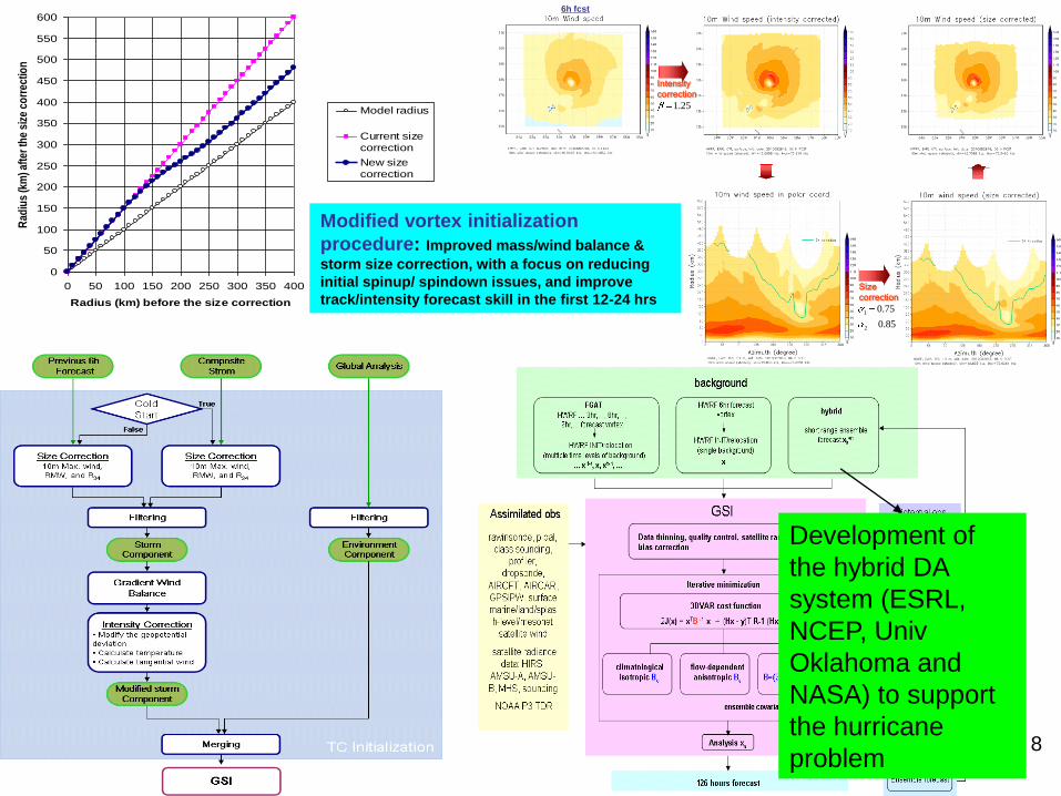
NCEP/EMC HWRF Modeling System Current Status … 6h fcst Modified vortex initialization procedure:...
32
1 NCEP/EMC HWRF Modeling System Current Status and Prioritized Stream 1.0 needs for FY11 Vijay Tallapragada HWRF Team Lead, NCEP/EMC HFIP Annual Review Meeting, Miami, FL November 9, 2010
-
Upload
trinhduong -
Category
Documents
-
view
224 -
download
4
Transcript of NCEP/EMC HWRF Modeling System Current Status … 6h fcst Modified vortex initialization procedure:...
1
NCEP/EMC HWRF Modeling System
Current Status and Prioritized Stream
1.0 needs for FY11
Vijay Tallapragada
HWRF Team Lead, NCEP/EMC
HFIP Annual Review Meeting, Miami, FL
November 9, 2010

2
The HWRF Team at EMC
• Vijay Tallapragada (Team Lead)– Model development, T&E, operational support,
verification and diagnostics
• Robert Tuleya*
– Physics and Product Development
• Qingfu Liu
– Vortex initialization and Physics
• Young Kwon– Physics and model development
• Zhan Zhang– Ensembles, pre-implementation testing
• Sam Trahan– Code management, product automation, software
support, pre-implementation testing
• Eric Aligo– Microphysics, radiation, model diagnostics
• Janna O’Connor– Graphics, website maintenance, organization of
weekly meetings
• Bill Lapenta and Steve Lord
– Management and Support
• MMAB Collaborators– Hyun-Sook Kim
– Jamese Sims
– Hae-Cheol Kim
– Dan Iredell
• DA Collaborators– John Derber
– Mingjing Tong
– In-Hyuk Kwon
– Emily Liu (JCSDA/HFIP)
• GCWMB Collaborators– Hua-Lu Pan
– Dmitry Sheinin
– Fanglin Yang
• MMB Collaborators– Dusan Jovic, Tom Black
– Matt Pyle, Brad Ferrier
• Ensemble Team– Jiyayi Peng
• Land Surface– Yihua Wu
• NHC– Wallace Hogsett
3
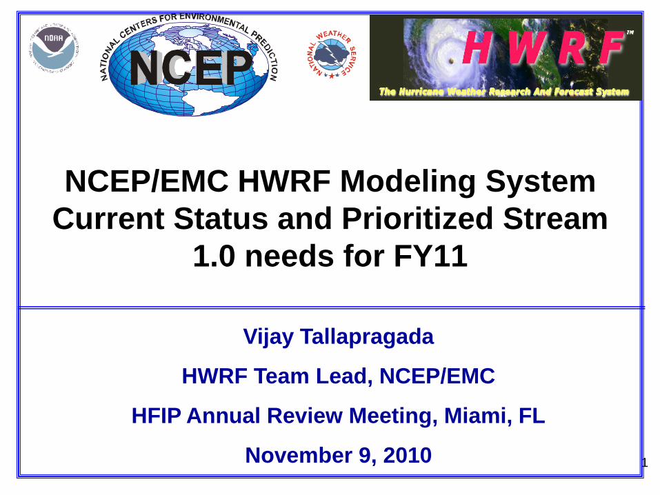
Operational HWRF Modeling System• Current operational HWRF
– Regional-Scale Ocean-Atmosphere Coupled Modeling System
– Non-Hydrostatic system of equations formulated on a rotated latitude-longitude, Arakawa E-grid and a vertical, pressure hybrid (sigma-P) coordinate.
– Based on WRF NMM V2.0 framework with movable, vortex following high-resolution nested grid, 27 km outer domain, 9 km inner domain, 42 vertical levels
– Coupled to Princeton Ocean Model (POM) in the Atlantic (with feature based initialization of cold wake, loop current, warm and cold core eddies)
– Physical parameterizations designed for tropical environment (GFS/GFDL SAS Convection and PBL, GFDL Surface Physics, Radiation, Ferrier Microphysics)
– Advanced vortex initialization and GSI/3DVAR data assimilation consisting of Vortex relocation, Storm size and intensity correction based on tcvitals, Assimilation of satellite radiance datasets in the hurricane environment and combination of bogus (synthetic) vortex and six-hour cycling
• Upgrades implemented in 2010 to improve the forecast skill.
– New baseline version with several bug fixes
– Modified surface physics formulation and use of Gravity Wave Drag parameterization
– Addition of satellite radiance data assimilation in the hurricane environment
– Focus on reducing intensity bias and improve track forecasts
4
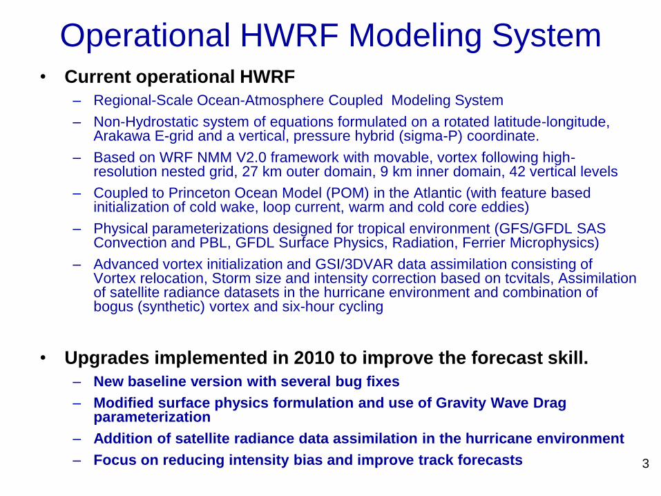
HWRF Atlantic Track Forecast Errors HWRF Atlantic Intensity Forecast Errors
(less skillful at all times)
Negative bias for HWRF Atlantic Intensity
Forecasts
Performance of the Operational HWRF for 2010 ATL hurricane season (till date)
Rapid growth of
intensity errors
5
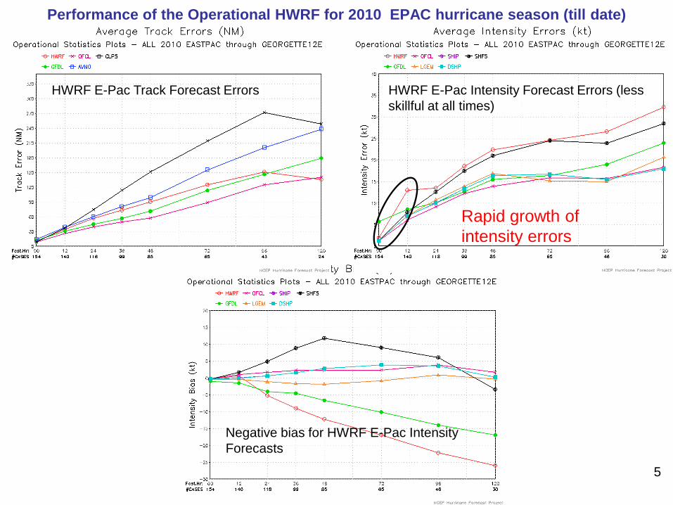
HWRF E-Pac Track Forecast Errors HWRF E-Pac Intensity Forecast Errors (less
skillful at all times)
Negative bias for HWRF E-Pac Intensity
Forecasts
Performance of the Operational HWRF for 2010 EPAC hurricane season (till date)
Rapid growth of
intensity errors
6
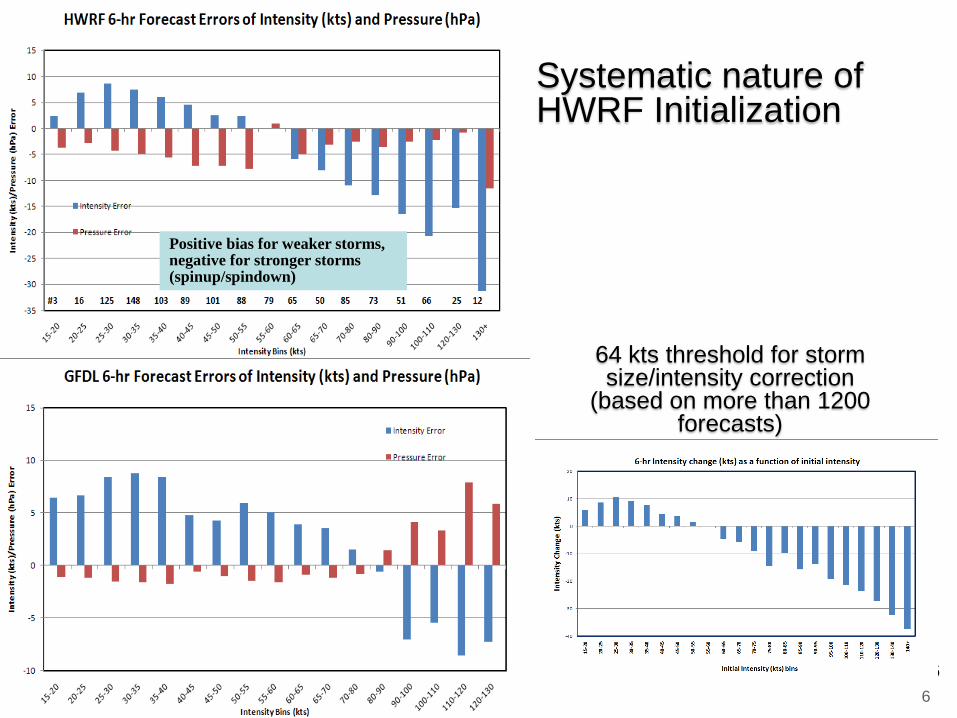
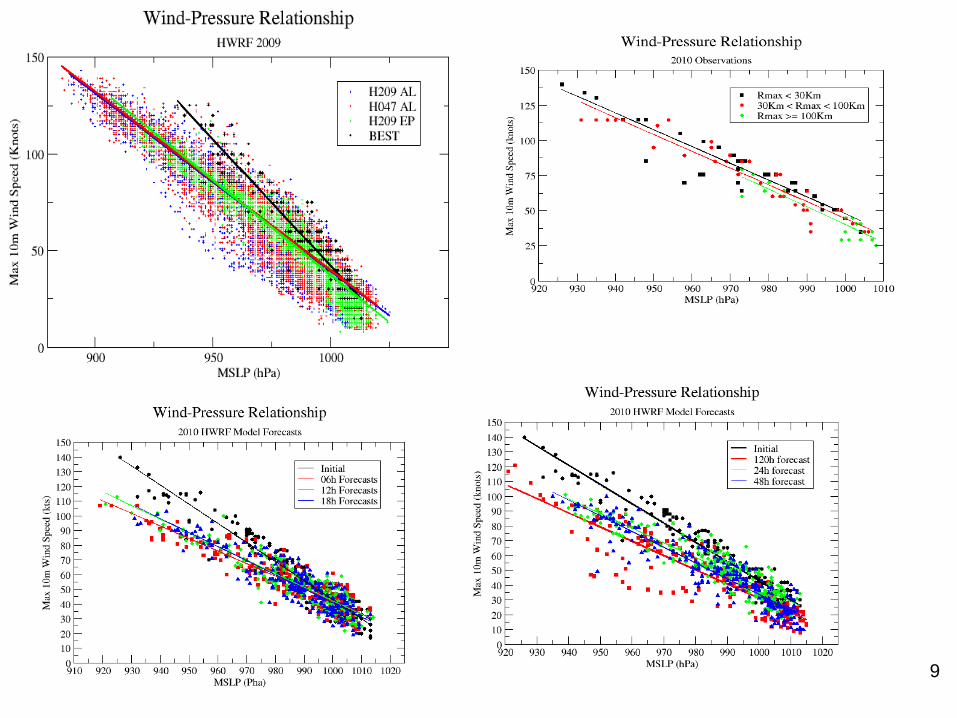
64 kts threshold for storm size/intensity correction
(based on more than 1200 forecasts)
Systematic nature of HWRF Initialization
6
Positive bias for weaker storms, negative for stronger storms (spinup/spindown)
7
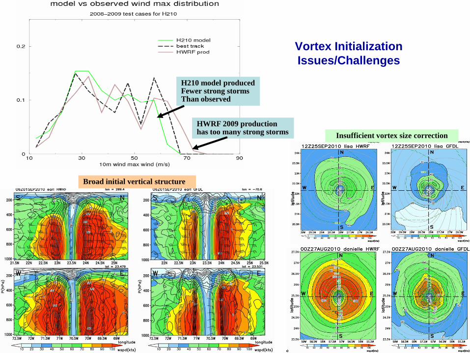
Vortex Initialization
Issues/Challenges
Broad initial vertical structure
Insufficient vortex size correction
H210 model producedFewer strong storms Than observed
HWRF 2009 productionhas too many strong storms
8
0
50
100
150
200
250
300
350
400
450
500
550
600
0 50 100 150 200 250 300 350 400
Radius (km) before the size correction
Rad
ius
(km
) aft
er th
e si
ze c
orr
ectio
n
Model radius
Current size
correction
New size
correction
Size
correction
Intensity
correction
25.1
85.0
75.0
2
1
6h fcst
Modified vortex initialization
procedure: Improved mass/wind balance &
storm size correction, with a focus on reducing
initial spinup/ spindown issues, and improve
track/intensity forecast skill in the first 12-24 hrs
Development of
the hybrid DA
system (ESRL,
NCEP, Univ
Oklahoma and
NASA) to support
the hurricane
problem
9
10
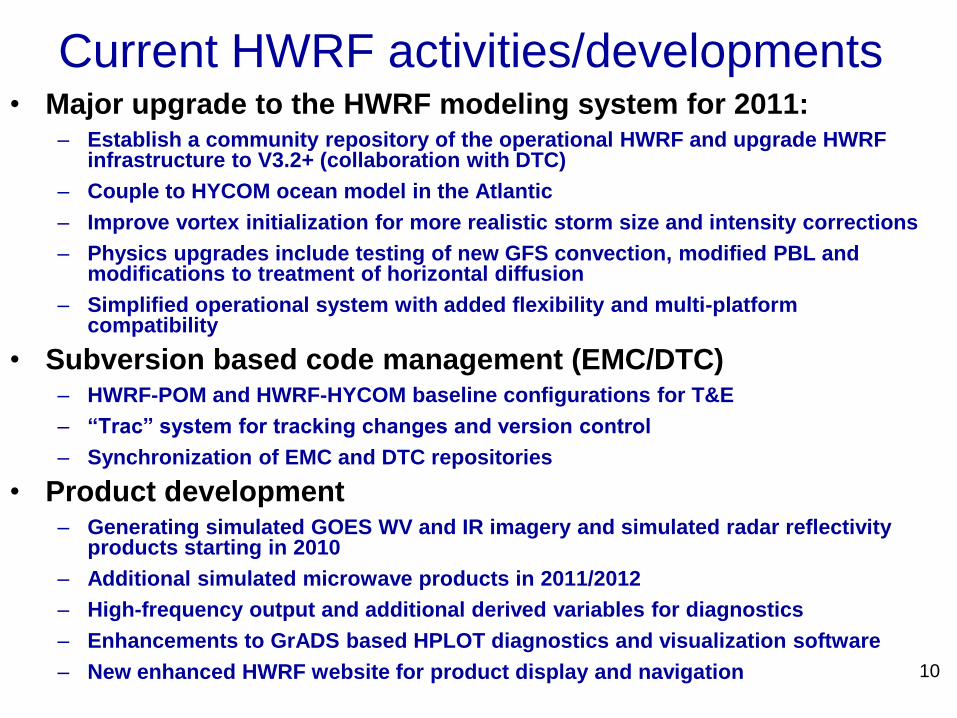
Current HWRF activities/developments• Major upgrade to the HWRF modeling system for 2011:
– Establish a community repository of the operational HWRF and upgrade HWRF infrastructure to V3.2+ (collaboration with DTC)
– Couple to HYCOM ocean model in the Atlantic
– Improve vortex initialization for more realistic storm size and intensity corrections
– Physics upgrades include testing of new GFS convection, modified PBL and modifications to treatment of horizontal diffusion
– Simplified operational system with added flexibility and multi-platform compatibility
• Subversion based code management (EMC/DTC)– HWRF-POM and HWRF-HYCOM baseline configurations for T&E
– “Trac” system for tracking changes and version control
– Synchronization of EMC and DTC repositories
• Product development– Generating simulated GOES WV and IR imagery and simulated radar reflectivity
products starting in 2010
– Additional simulated microwave products in 2011/2012
– High-frequency output and additional derived variables for diagnostics
– Enhancements to GrADS based HPLOT diagnostics and visualization software
– New enhanced HWRF website for product display and navigation
11
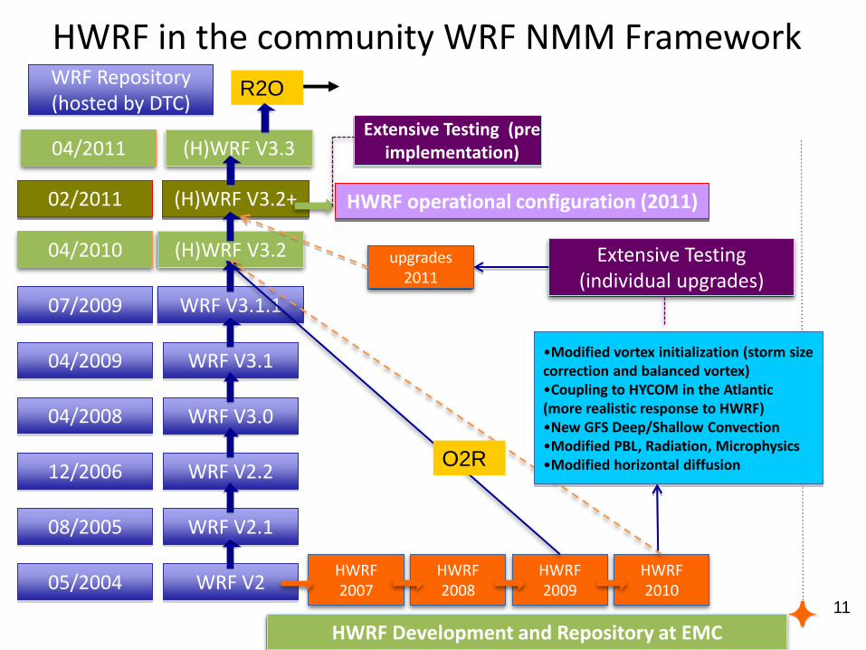
(H)WRF V3.2+
(H)WRF V3.2
WRF V3.1.1
WRF V3.1
WRF V3.0
WRF V2.2
WRF V2.1
WRF V205/2004
07/2009
04/2010
08/2005
12/2006
04/2008
04/2009
HWRF in the community WRF NMM Framework
HWRF operational configuration (2011)
Extensive Testing (pre implementation)
WRF Repository (hosted by DTC)
HWRF2007
HWRF2008
HWRF2009
HWRF2010
upgrades2011
•Modified vortex initialization (storm size correction and balanced vortex)•Coupling to HYCOM in the Atlantic (more realistic response to HWRF)•New GFS Deep/Shallow Convection•Modified PBL, Radiation, Microphysics•Modified horizontal diffusion
Extensive Testing (individual upgrades)
HWRF Development and Repository at EMC
02/2011
04/2011 (H)WRF V3.3
O2R
R2O
12
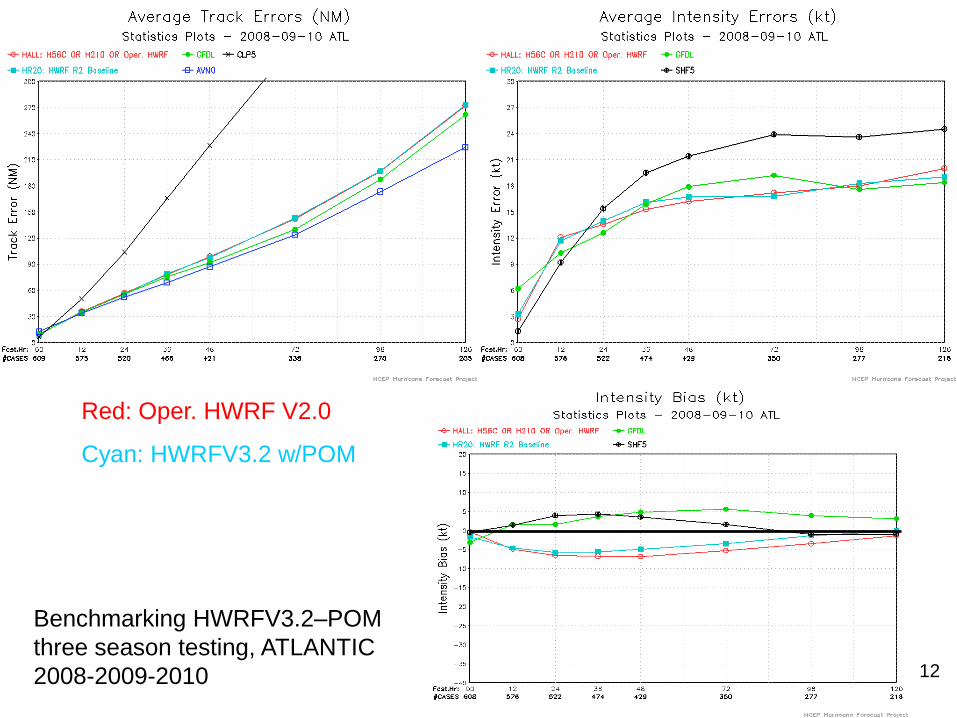
Benchmarking HWRFV3.2–POM
three season testing, ATLANTIC
2008-2009-2010
Red: Oper. HWRF V2.0
Cyan: HWRFV3.2 w/POM
13
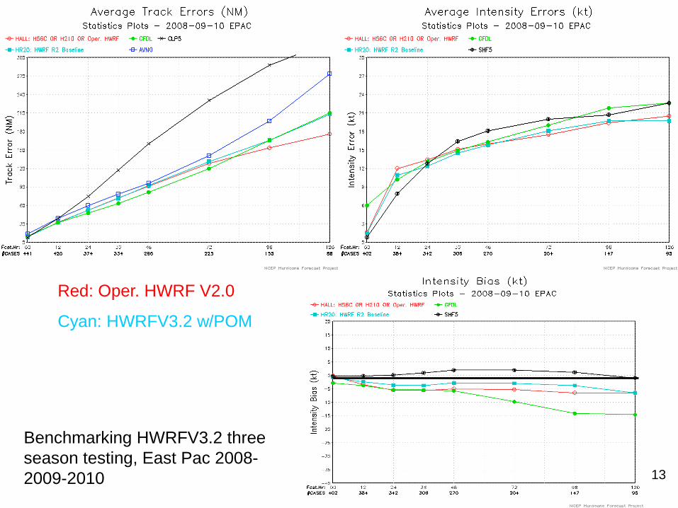
Red: Oper. HWRF V2.0
Cyan: HWRFV3.2 w/POM
Benchmarking HWRFV3.2 three
season testing, East Pac 2008-
2009-2010
14
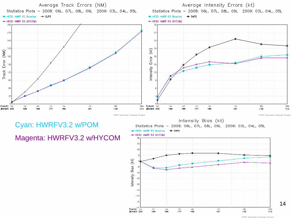
Cyan: HWRFV3.2 w/POM
Magenta: HWRFV3.2 w/HYCOM
15
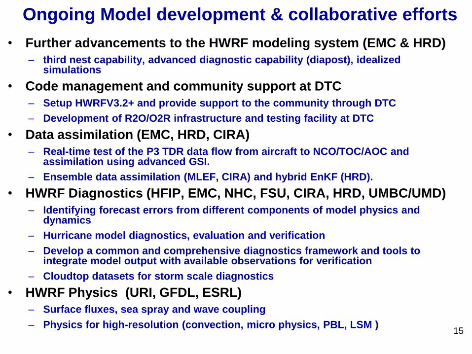
Ongoing Model development & collaborative efforts
• Further advancements to the HWRF modeling system (EMC & HRD)
– third nest capability, advanced diagnostic capability (diapost), idealized simulations
• Code management and community support at DTC
– Setup HWRFV3.2+ and provide support to the community through DTC
– Development of R2O/O2R infrastructure and testing facility at DTC
• Data assimilation (EMC, HRD, CIRA)
– Real-time test of the P3 TDR data flow from aircraft to NCO/TOC/AOC and assimilation using advanced GSI.
– Ensemble data assimilation (MLEF, CIRA) and hybrid EnKF (HRD).
• HWRF Diagnostics (HFIP, EMC, NHC, FSU, CIRA, HRD, UMBC/UMD)
– Identifying forecast errors from different components of model physics and dynamics
– Hurricane model diagnostics, evaluation and verification
– Develop a common and comprehensive diagnostics framework and tools to integrate model output with available observations for verification
– Cloudtop datasets for storm scale diagnostics
• HWRF Physics (URI, GFDL, ESRL)
– Surface fluxes, sea spray and wave coupling
– Physics for high-resolution (convection, micro physics, PBL, LSM )
16
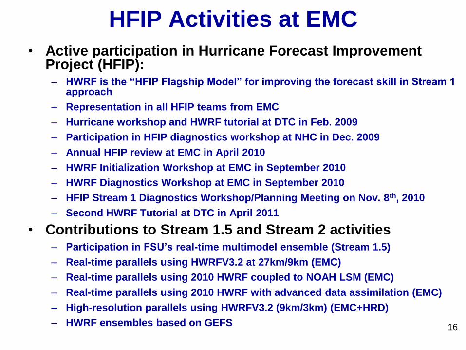
HFIP Activities at EMC
• Active participation in Hurricane Forecast Improvement Project (HFIP):
– HWRF is the “HFIP Flagship Model” for improving the forecast skill in Stream 1 approach
– Representation in all HFIP teams from EMC
– Hurricane workshop and HWRF tutorial at DTC in Feb. 2009
– Participation in HFIP diagnostics workshop at NHC in Dec. 2009
– Annual HFIP review at EMC in April 2010
– HWRF Initialization Workshop at EMC in September 2010
– HWRF Diagnostics Workshop at EMC in September 2010
– HFIP Stream 1 Diagnostics Workshop/Planning Meeting on Nov. 8th, 2010
– Second HWRF Tutorial at DTC in April 2011
• Contributions to Stream 1.5 and Stream 2 activities– Participation in FSU’s real-time multimodel ensemble (Stream 1.5)
– Real-time parallels using HWRFV3.2 at 27km/9km (EMC)
– Real-time parallels using 2010 HWRF coupled to NOAH LSM (EMC)
– Real-time parallels using 2010 HWRF with advanced data assimilation (EMC)
– High-resolution parallels using HWRFV3.2 (9km/3km) (EMC+HRD)
– HWRF ensembles based on GEFS
17
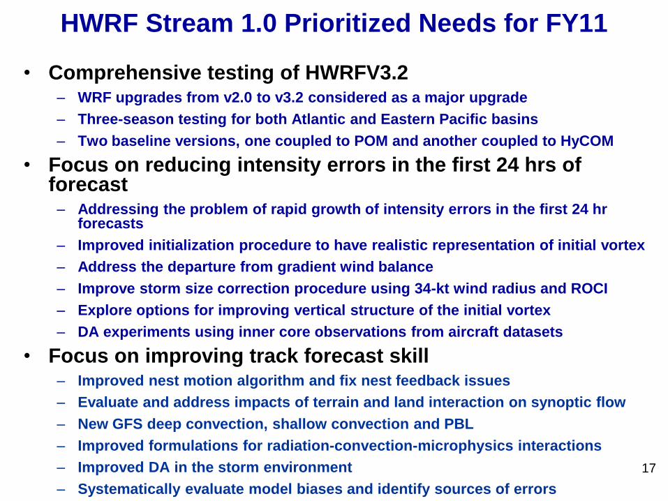
HWRF Stream 1.0 Prioritized Needs for FY11
• Comprehensive testing of HWRFV3.2 – WRF upgrades from v2.0 to v3.2 considered as a major upgrade
– Three-season testing for both Atlantic and Eastern Pacific basins
– Two baseline versions, one coupled to POM and another coupled to HyCOM
• Focus on reducing intensity errors in the first 24 hrs of forecast
– Addressing the problem of rapid growth of intensity errors in the first 24 hr forecasts
– Improved initialization procedure to have realistic representation of initial vortex
– Address the departure from gradient wind balance
– Improve storm size correction procedure using 34-kt wind radius and ROCI
– Explore options for improving vertical structure of the initial vortex
– DA experiments using inner core observations from aircraft datasets
• Focus on improving track forecast skill– Improved nest motion algorithm and fix nest feedback issues
– Evaluate and address impacts of terrain and land interaction on synoptic flow
– New GFS deep convection, shallow convection and PBL
– Improved formulations for radiation-convection-microphysics interactions
– Improved DA in the storm environment
– Systematically evaluate model biases and identify sources of errors
18
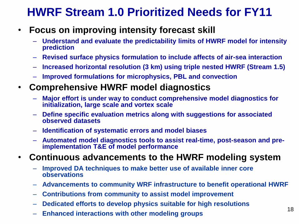
HWRF Stream 1.0 Prioritized Needs for FY11
• Focus on improving intensity forecast skill – Understand and evaluate the predictability limits of HWRF model for intensity
prediction
– Revised surface physics formulation to include affects of air-sea interaction
– Increased horizontal resolution (3 km) using triple nested HWRF (Stream 1.5)
– Improved formulations for microphysics, PBL and convection
• Comprehensive HWRF model diagnostics – Major effort is under way to conduct comprehensive model diagnostics for
initialization, large scale and vortex scale
– Define specific evaluation metrics along with suggestions for associated observed datasets
– Identification of systematic errors and model biases
– Automated model diagnostics tools to assist real-time, post-season and pre-implementation T&E of model performance
• Continuous advancements to the HWRF modeling system– Improved DA techniques to make better use of available inner core
observations
– Advancements to community WRF infrastructure to benefit operational HWRF
– Contributions from community to assist model improvement
– Dedicated efforts to develop physics suitable for high resolutions
– Enhanced interactions with other modeling groups
19
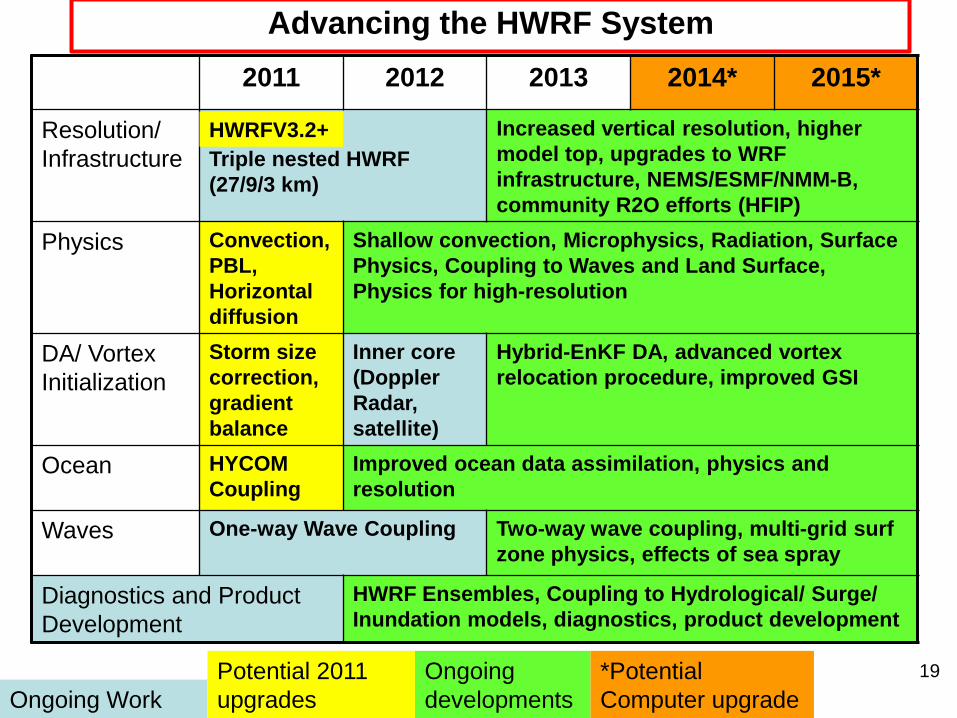
Advancing the HWRF System
.
2011 2012 2013 2014* 2015*
Resolution/
Infrastructure Triple nested HWRF
(27/9/3 km)
Increased vertical resolution, higher
model top, upgrades to WRF
infrastructure, NEMS/ESMF/NMM-B,
community R2O efforts (HFIP)
Physics Convection,
PBL,
Horizontal
diffusion
Shallow convection, Microphysics, Radiation, Surface
Physics, Coupling to Waves and Land Surface,
Physics for high-resolution
DA/ Vortex
Initialization
Storm size
correction,
gradient
balance
Inner core
(Doppler
Radar,
satellite)
Hybrid-EnKF DA, advanced vortex
relocation procedure, improved GSI
Ocean HYCOM
Coupling
Improved ocean data assimilation, physics and
resolution
Waves One-way Wave Coupling Two-way wave coupling, multi-grid surf
zone physics, effects of sea spray
Diagnostics and Product
Development
HWRF Ensembles, Coupling to Hydrological/ Surge/
Inundation models, diagnostics, product development
Ongoing Work
Potential 2011
upgrades
Ongoing
developments
*Potential
Computer upgrade
HWRFV3.2+
20
Thanks for your attention
Questions?
Real-time and pre-implementation T&E
HWRF products: http://www.emc.ncep.noaa.gov/gc_wmb/vxt/index.html
21
Additional Slides
• Key issues
22
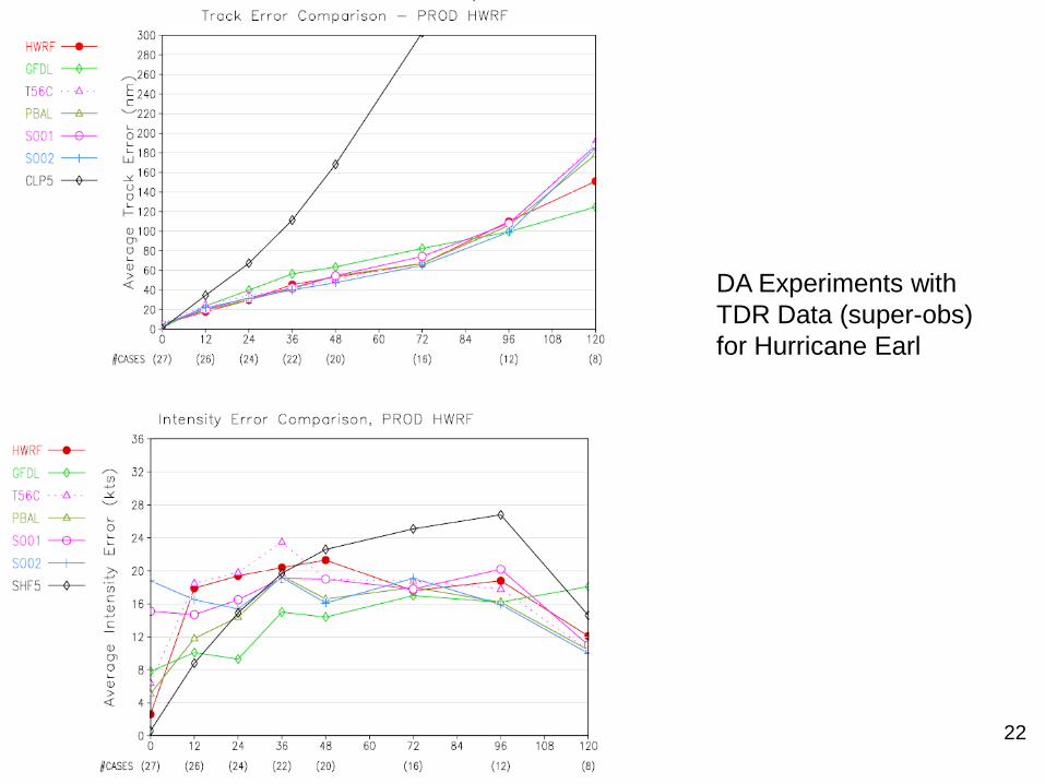
DA Experiments with
TDR Data (super-obs)
for Hurricane Earl
23
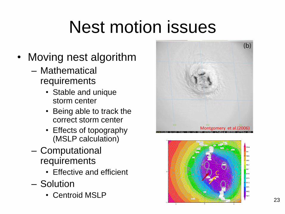
Nest motion issues
• Moving nest algorithm– Mathematical
requirements• Stable and unique
storm center
• Being able to track the correct storm center
• Effects of topography (MSLP calculation)
– Computational requirements
• Effective and efficient
– Solution• Centroid MSLP
Montgomery et al.(2006)
C
24
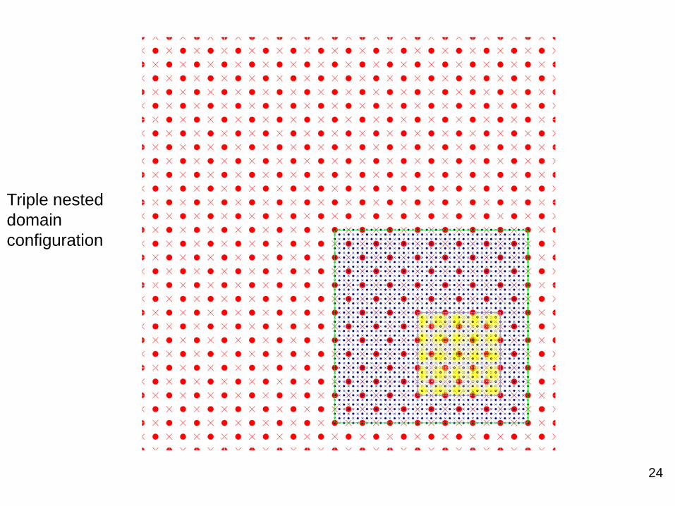
Triple nested
domain
configuration
25
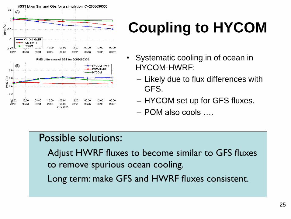
Coupling to HYCOM
• Systematic cooling in of ocean in
HYCOM-HWRF:
– Likely due to flux differences with
GFS.
– HYCOM set up for GFS fluxes.
– POM also cools ….
Possible solutions:
◦ Adjust HWRF fluxes to become similar to GFS fluxes
to remove spurious ocean cooling.
◦ Long term: make GFS and HWRF fluxes consistent.
26
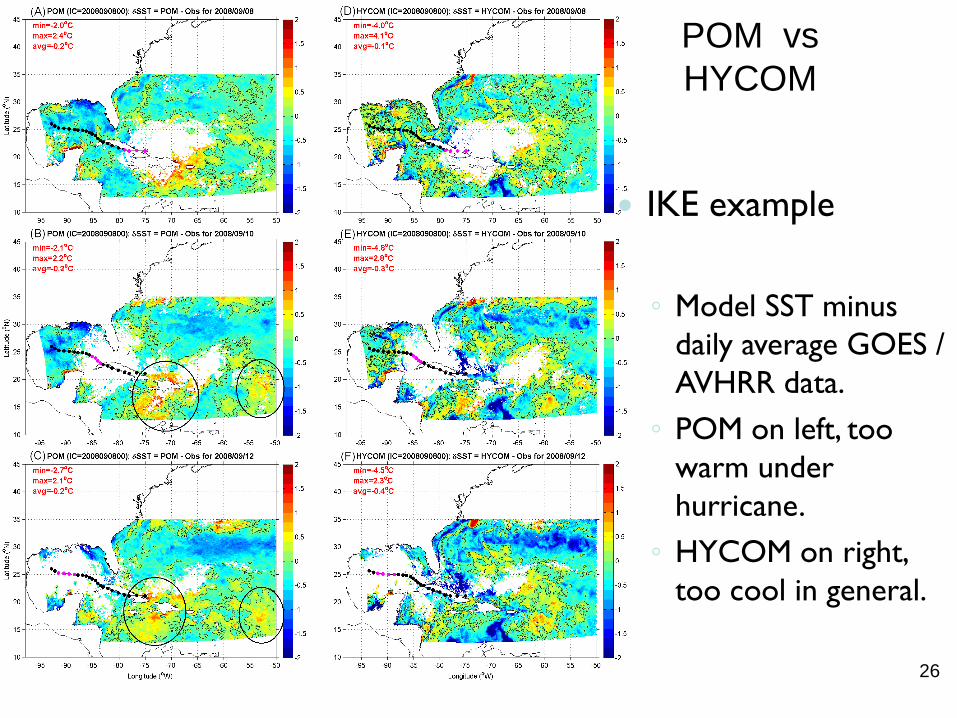
POM vs
HYCOM
IKE example
◦ Model SST minus
daily average GOES /
AVHRR data.
◦ POM on left, too
warm under
hurricane.
◦ HYCOM on right,
too cool in general.
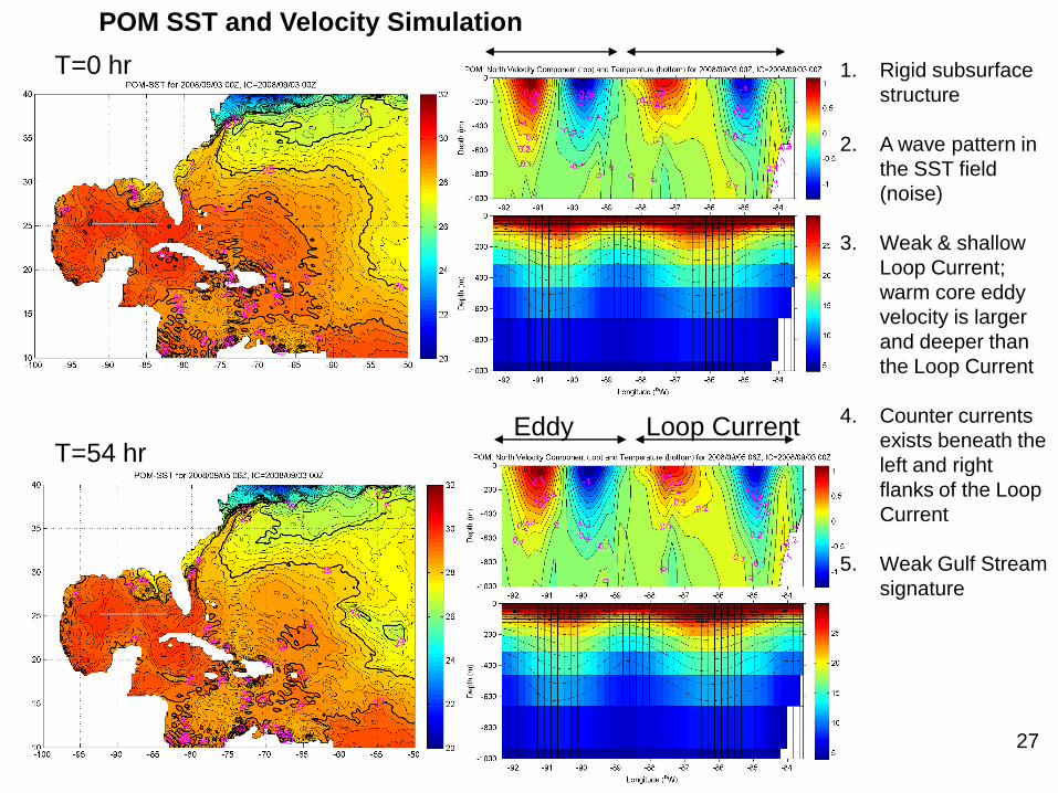
27
Eddy Loop CurrentT=54 hr
T=0 hr 1. Rigid subsurface
structure
2. A wave pattern in
the SST field
(noise)
3. Weak & shallow
Loop Current;
warm core eddy
velocity is larger
and deeper than
the Loop Current
4. Counter currents
exists beneath the
left and right
flanks of the Loop
Current
5. Weak Gulf Stream
signature
POM SST and Velocity Simulation
28
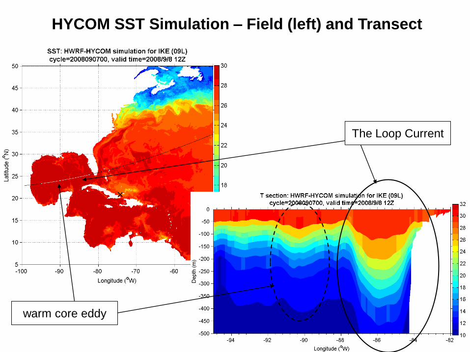
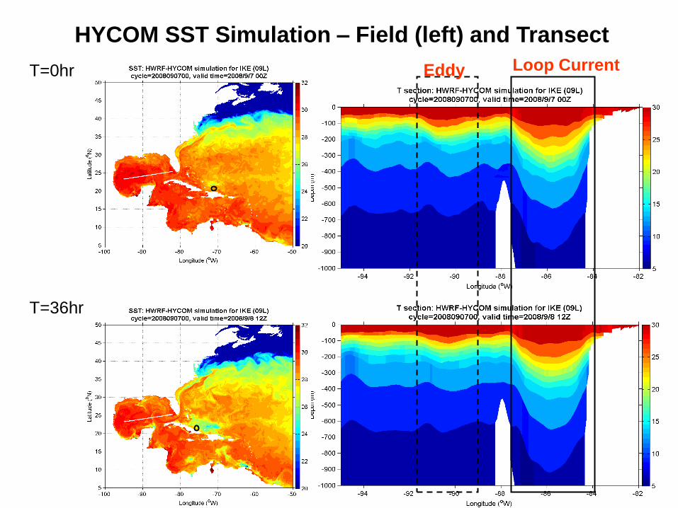
HYCOM SST Simulation – Field (left) and Transect
The Loop Current
warm core eddy
29
Eddy Loop CurrentT=0hr
T=36hr
HYCOM SST Simulation – Field (left) and Transect
30
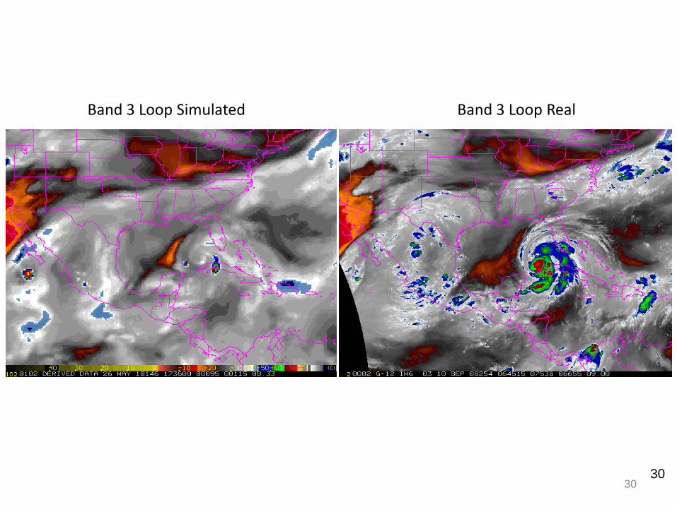
Band 3 Loop Simulated Band 3 Loop Real
30
31
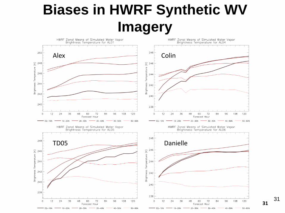
Biases in HWRF Synthetic WV
Imagery
Alex Colin
TD05 Danielle
31
32
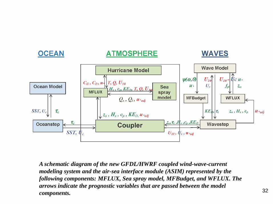
A schematic diagram of the new GFDL/HWRF coupled wind-wave-current
modeling system and the air-sea interface module (ASIM) represented by the
following components: MFLUX, Sea spray model, MFBudget, and WFLUX. The
arrows indicate the prognostic variables that are passed between the model
components.