
Natural Infrastructure Management Part II: Implementation
24
I n t e g r i t y - S e r v i c e - E x c e l l e n c e Headquarters U.S. Air Force 1 Natural Infrastructure Management Part II: Implementation Lt Col Jeff Cornell Office of the Deputy Assistant Secretary US Air Force
-
Upload
seth-mendez -
Category
Documents
-
view
15 -
download
0
description
Natural Infrastructure Management Part II: Implementation. Lt Col Jeff Cornell Office of the Deputy Assistant Secretary US Air Force. “The Infrastructures”. Definition of Infrastructure: An Integrated System, Holistically Managed, Supporting the Combat Mission - PowerPoint PPT Presentation
Transcript of Natural Infrastructure Management Part II: Implementation

I n t e g r i t y - S e r v i c e - E x c e l l e n c e
Headquarters U.S. Air Force
1
Natural Infrastructure Management Part II: Implementation
Lt Col Jeff CornellOffice of the
Deputy Assistant Secretary US Air Force

2
“The Infrastructures”
Definition of Infrastructure: An Integrated System, Holistically Managed, Supporting the Combat Mission
Examples of Infrastructure: Workforce Force Protection / Security Built Logisitical Communications / Information Systems Natural

3
Infrastructure Management
InventoryConditionValuePlanning
SustainRestoreModernize

4
What Does “Natural Infrastructure” Really Mean?

5
Visualizing the Natural Infrastructure
COMPONENTS• Airspace• Air Shed Emissions Availability• AICUZ (Noise Bands)• Groundwater Access• Groundwater
Discharge Availability• Surface Land Access• Surface Water
Access & Discharge Availability
• Subsurface Land Access
• Spectrum
COMPETITION• Civil Aviation• Commercial Communication• Noise Ordinances• Protected Habitat• Comm. / Res. Development• Population Growth• Tradable Emissions
6
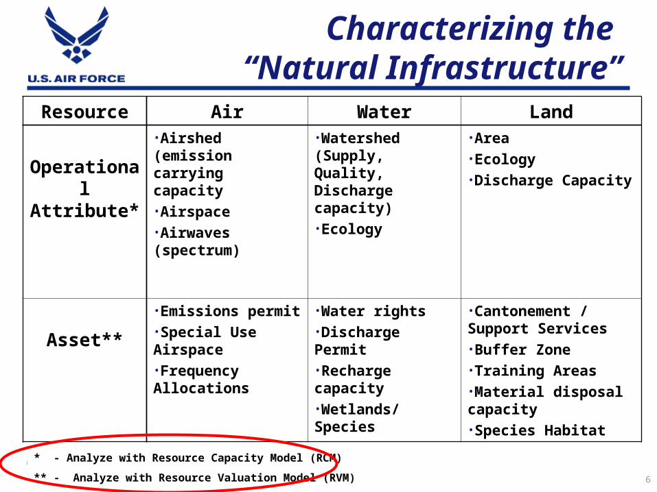
Characterizing the “Natural Infrastructure”
Resource Air Water Land
Operational Attribute*
•Airshed (emission carrying capacity•Airspace•Airwaves (spectrum)
•Watershed (Supply, Quality, Discharge capacity)•Ecology
•Area•Ecology•Discharge Capacity
Asset**
•Emissions permit•Special Use Airspace•Frequency Allocations
•Water rights•Discharge Permit•Recharge capacity•Wetlands/Species
•Cantonement / Support Services•Buffer Zone•Training Areas•Material disposal capacity•Species Habitat
* - Analyze with Resource Capacity Model (RCM)
** - Analyze with Resource Valuation Model (RVM)

7
What We’re Changing
Focusing Management on the Entire Natural Infrastructure
Setting Goals to Prevent Encroachment Based On: Combat Capability Support Performance! (not process…)
Managing the Natural Infrastructure as a Group of Assets (not liabilities…)

8
Competition for the Natural Infrastructure

9
DoD Ranges, Airspace, and AF Bases

10
Population, Airspace, DoD Ranges

11
Federal Lands (including DoD lands)

12
Population, Airspace,Federal Lands
Produced by the HQ AF Ranges and Airspace GIS Project


14

15
Definitions
SUSTAINMENT:
Keeping pace with what you need
ENCROACHMENT:
Loss of access to, or degradation of the capability of natural infrastructure to support operations

16
Measuring the Impact – the RCM Model
Resource Capability Model (RCM) developed to measure resource adequacy, including resource deficiency and opportunity

17
RCM Methodology Overview
Determine CorrespondingResource
Requirements
Determine OperationalRequirements
Other
EmergingSystems
LegacySystems
Studies and
Planning Document
s
Determine ResourceAvailability
Geospatial Data
Compare resource requirements against resource availability foreach resource category using metrics
Resource Categories:• Airspace• Air Shed Emissions Availability• AICUZ (Noise Bands)• Groundwater Access• Groundwater Discharge Availability• Surface Land Access• Surface Water Access & Discharge Availability• Subsurface Land Access• Spectrum
Resource ReadinessRatings per Metric*
RD1 -- Some deficiencies
RD2 -- Significant
deficiencies
RD3 -- Major deficiencies
RO3 – Major opportunities
RO2 -- Significant opportunities
RO1 – Some opportunities
RR – Adequate (Minor
opportunities or deficiencies)
*RO = Resource Opportunity
*RD = Resource Deficiency

18
RCM Breakpoints, Color Codes, Rating Codes*
* Percentages results from comparison of resource availability to resource requirements, using 100% as the baseline for breakpoints.
Adequate
Opportunity
Deficiency
RO = Resource OpportunityRD = Resource Deficiency
I NITIAL B REAK
P OINTS *
COLOR CODES RATING CODES
> 140% RO3
> 120-140% RO2
>110 - 120% RO1
110 - 90% RR
< 90- 80% RD1
< 80 - 60% RD2
< 60% RD3
BREAKPOINTS
ENCROACHMENT
SUSTAINM
ENT

19
AirspaceMetric 1
CompatibleVolume
AirspaceMetric 2
Hours
AirspaceMetric 3
Distance
AirspaceMetric 4
MinimumSize
Dimensions
Surface Land Access
Metric 1
Surface Land Access
Metric 2
Surface Water
Discharge Availability
Ground Water
Access(Supply)
RR
RD3
RO2 RO2RD1 RRRO3 RO3
• Range has some resource opportunity• Approximately 1.4% airspace encroachment using Metric #1 at range• There is no validated method in AF to size airspace for Metric 4. Required airspace
dimensions generated by 20 FW staff for pilot test purposes only• Approximately 12.1% off-range surface land encroachment using Metric #1
Tested Metrics
Airspace Readiness Ratings for Poinsett Range

20
Airspace Readiness Ratings for OCONUS Range
Airspace: Installation Rating Color
Metric 1: Compatible Volume RR
Metric 2: Time Volume Denied RR
Metric 3: Hours RO3
Metric 4: Distance N/A N/A
Metric 5: Minimum Size Dimensions N/A N/A
Airspace: Range
Metric 1: Compatible Volume RR
Metric 2: Time Volume Denied RD3
Metric 3: Hours RO3
Metric 4: Distance RD3
Metric 5: Minimum Size Dimensions – F-16CJ RD3
Metric 5: Minimum Size Dimensions – A-10 RD3

21
• Resource Requirements defined by acres within 65+ dB contours
• Total acres = 9600• Off-base acres = 6300• On-base acres = 3300
• Resource Availability defined by “compatible acres”
• 700 - 945 incompatible acres off-base determined using FAA guidelines
• 5355 - 5600 compatible acres off-base• 85.0-88.8% compatible acres off-base,
or 11.2 - 15% encroachment
Surface Land Resource Adequacy Determination

22
RCM Pilot Test Chronology
• 2003 Pilot Test Shaw AFB Pilot Test Luke AFB Briefed executive summary to XOO, SAF/IEE, XIC, ESOH
Committee, DoD ESOH Policy Board, RRPI Executive Group and WIPT
• 2004 Pilot Test NJANG ACC Full Implementation Pilot Test Spangdahlem AB

23
Some Practical Implications
Traditional Environmental Management Structures Should be “deconstructed”;
Replaced by “Natural Infrastructure Planning”
Natural Infrastructure Requirement Analysis Conducted With or Before: Basing Decisions Military Planning (Contingencies, Weapon System
Design, etc.) Environmental Impact Analysis

I n t e g r i t y - S e r v i c e - E x c e l l e n c e
Headquarters U.S. Air Force
24
Natural Natural Infrastructure Infrastructure ManagementManagement Part II: Part II: Implementation Implementation
Lt Col Jeff CornellOffice of the
Deputy Assistant Secretary US Air Force
THANK YOU