Arizona’s Natural Infrastructure
1
Arizona’s Natural Infrastructure Arizona’s natural infrastructure includes lands & waters that preserve the state’s natural heritage and open space. We developed a natural infrastructure dataset by integrating 12 studies on conservation and open space lands, and used the data to evaluate the potential impacts of Arizona’s future growth. Projected growth impacts in 2050 Sensitive Biological Lands & Waters Wildlife linkages – potential wildlife movement corridors identified by 9 public agen- cies and nonprofit organizations Core habitats – core habitats for species throughout Arizona, identified by ecoregional assessments conducted by The Nature Conservancy and collaborators Priority grasslands – High-quality grasslands in Arizona, New Mexico, and northern Mexico identified by The Nature Conservancy’s grasslands assessment Pima Co bond lands – important lands prioritized by the Sonoran Desert Conservation Plan and authorized for acquisition by the 2004 Pima County Conservation Bond election Arizona protected areas – public & private lands demonstrating biological or natural resource value which are permanently protected from development Open Space Arizona open spaces – public & private lands and waters that are permanently protected from development and were established for public enjoyment and recreation County & municipality planned open spaces – lands & waters proposed as open space designation in county or municipality plans What is Natural Infrastructure? Rivers 1 Arizona Department of Economic Security – http://www.azcommerce.com/EconInfo/Demographics 2 Maricopa Association of Governments – Source for growth projections. The contents of this report reflect the views of the Licensee who is responsible for the facts and ac- curacy of the data presented herein. The contents do not necessarily reflect the official views or policies of MAG and have not been approved or endorsed by MAG. 3 These analyses do not account for the effects of growth on Arizona’s groundwater and streams that support riparian habitat, loss of which will impact many more species. Alternative scenarios of Arizona’s growth & natural infrastructure in 2050 For more information & GIS data visit azconservation.org Arizona’s population is projected to double by 2050 1 , and the associated urban footprint may quadruple 2 . If growth follows current projections, we could lose nearly 2 million acres of natural infrastructure by 2050. This loss of desert, grassland, and forest habitat could adversely impact at least 120 species of concern 3 . Most of Arizona’s future population growth will be concentrated in the Sun Corridor – the metro counties that encompass Phoenix and Tucson. Based on current growth projections, 600,000 acres of natural infrastructure will be lost to urban growth by 2050 in the Sun Corridor (left). However, there are 2.7 million acres of private and state lands outside of the natural infrastructure and within 30 miles of ex- isting highways that are currently undeveloped. Shifting projected development into these areas would minimize direct impacts to the natural infrastructure (right). 2000 2050 Dan Majka [email protected] Marcos Robles [email protected] Rob Marshall [email protected] Natural infrastructure, including sensitive biological lands & open space Current and future growth outside the natural infrastructure Natural infrastructure that could be lost to growth – nearly 2 million acres by 2050 Current and future growth outside the natural infrastructure Natural infrastructure that could be lost to growth - 600,000 acres in the Sun Corridor Private & State Trust lands in the Sun Corridor more suitable for development Current growth pattern Alternative growth corridor
Transcript of Arizona’s Natural Infrastructure
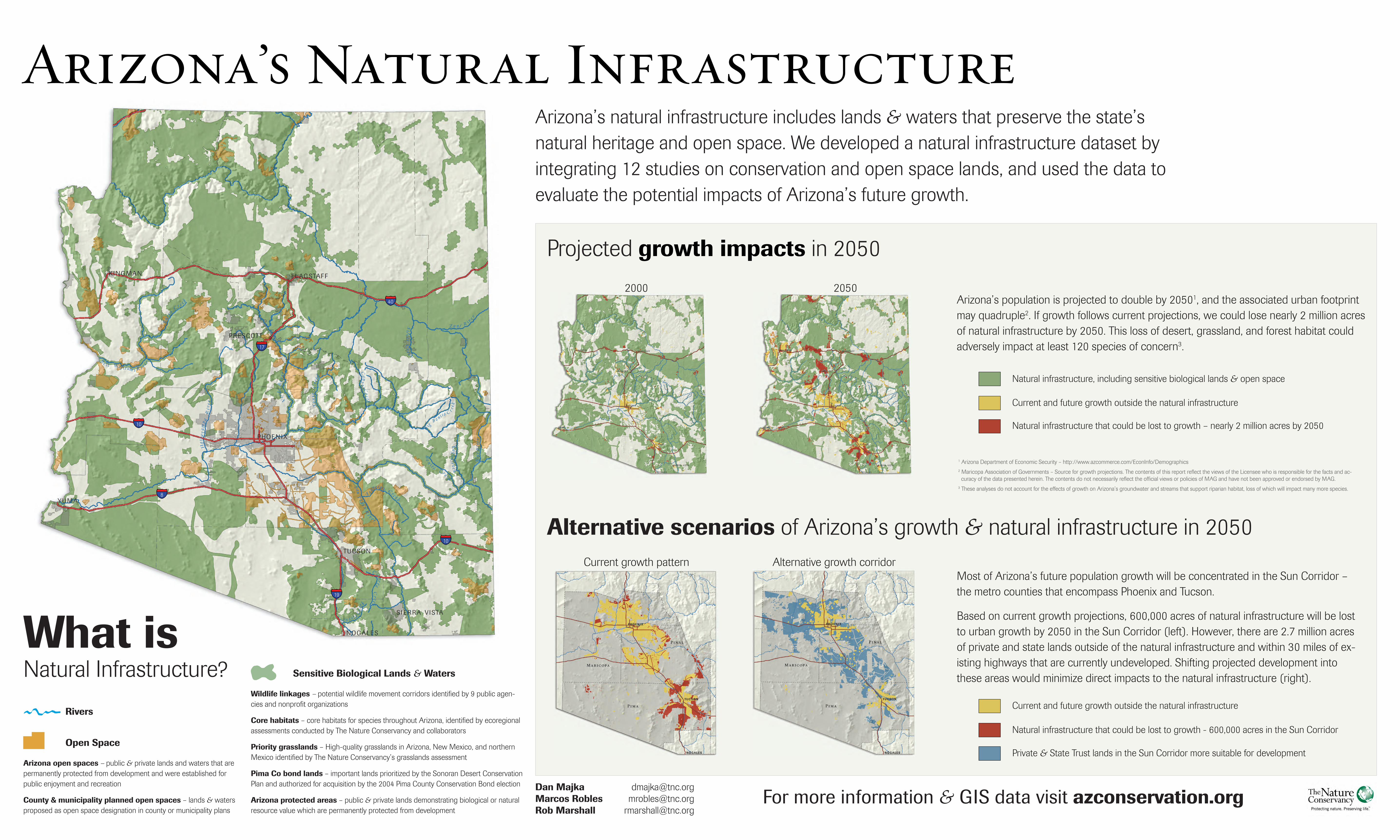
Arizona’s Natural InfrastructureArizona’s natural infrastructure includes lands & waters that preserve the state’s natural heritage and open space. We developed a natural infrastructure dataset by integrating 12 studies on conservation and open space lands, and used the data to evaluate the potential impacts of Arizona’s future growth.
Projected growth impacts in 2050
Sensitive Biological Lands & Waters
Wildlife linkages – potential wildlife movement corridors identified by 9 public agen-cies and nonprofit organizations
Core habitats – core habitats for species throughout Arizona, identified by ecoregional assessments conducted by The Nature Conservancy and collaborators
Priority grasslands – High-quality grasslands in Arizona, New Mexico, and northern Mexico identified by The Nature Conservancy’s grasslands assessment
Pima Co bond lands – important lands prioritized by the Sonoran Desert Conservation Plan and authorized for acquisition by the 2004 Pima County Conservation Bond election
Arizona protected areas – public & private lands demonstrating biological or natural resource value which are permanently protected from development
Open Space
Arizona open spaces – public & private lands and waters that are permanently protected from development and were established for public enjoyment and recreation
County & municipality planned open spaces – lands & waters proposed as open space designation in county or municipality plans
What is Natural Infrastructure?
Rivers
1 Arizona Department of Economic Security – http://www.azcommerce.com/EconInfo/Demographics2 Maricopa Association of Governments – Source for growth projections. The contents of this report reflect the views of the Licensee who is responsible for the facts and ac-curacy of the data presented herein. The contents do not necessarily reflect the official views or policies of MAG and have not been approved or endorsed by MAG.
3 These analyses do not account for the effects of growth on Arizona’s groundwater and streams that support riparian habitat, loss of which will impact many more species.
Alternative scenarios of Arizona’s growth & natural infrastructure in 2050
For more information & GIS data visit azconservation.org
Arizona’s population is projected to double by 20501, and the associated urban footprint may quadruple2. If growth follows current projections, we could lose nearly 2 million acres of natural infrastructure by 2050. This loss of desert, grassland, and forest habitat could adversely impact at least 120 species of concern3.
Most of Arizona’s future population growth will be concentrated in the Sun Corridor – the metro counties that encompass Phoenix and Tucson.
Based on current growth projections, 600,000 acres of natural infrastructure will be lost to urban growth by 2050 in the Sun Corridor (left). However, there are 2.7 million acres of private and state lands outside of the natural infrastructure and within 30 miles of ex-isting highways that are currently undeveloped. Shifting projected development into these areas would minimize direct impacts to the natural infrastructure (right).
2000 2050
Dan Majka [email protected] Robles [email protected] Marshall [email protected]
Natural infrastructure, including sensitive biological lands & open space
Current and future growth outside the natural infrastructure
Natural infrastructure that could be lost to growth – nearly 2 million acres by 2050
Current and future growth outside the natural infrastructure
Natural infrastructure that could be lost to growth - 600,000 acres in the Sun Corridor
Private & State Trust lands in the Sun Corridor more suitable for development
Current growth pattern Alternative growth corridor