National Academy of Sciences— National Research …onlinepubs.trb.org/Onlinepubs/sr/sr43.pdf ·...
49
;• ___ , .-- '•l - : - V. - - National Academy of Sciences— National Research Council publication 672
Transcript of National Academy of Sciences— National Research …onlinepubs.trb.org/Onlinepubs/sr/sr43.pdf ·...
;• ___ ,
.--
'•l - :
- V.
- -
National Academy of Sciences—
National Research Council publication 672
HIGHWAY RESEARCH BOARD Officers and Members of the Executive Committee
1959
HARMER E. DAVIS, Chairman PYKE JOHNSON, First Vice Chairman
W. A; BUGGE, Second Vice Chairman
FRED BURGGRAF, Director
ELMER M. WARD, Assistant Director
Executive Committee
BERTRAM D. TALLAMY, Federal Highway Administrator, Bureau of Public Roads (ex officio)
A. E. JOHNSON, Executive Secretary, American Association. of State Highway Officials (ex officio)
Louis JORDAN, Executive Secretary, Division of Engineering and Industrial Research, National Research Council (ex officio)
C. H SCHOLER, Applied Mechanics Department, Kansas State College (ex officio, Past Chairman 1958)
REX M. WHITTON, Chief Engineer, Missouri State Highway Department (ex officio, Past Chairman 1957)
R. R. BARTELSMEYER, Chief Highway Engineer, Illinois Division of Highways
E. BUCHANAN, President, The Asphalt Institute
W. A. BUGGE, Director of Highways, Washington State Highway Commission
MASON A. BUTCHER, Director of Public Works, Montgomery County,Md. C. D. CURTISS, Special Assistant to the Executive Vice President, American Road
Builders Association HARMER E. DAVIS, Director, Insitute of Transportation and Traffic Engineering, Uni-
verèity of California DuKE W. DUNBAR, Attorney General of Colorado FRANCIS V. DU PONT, Consulting Engineer, Washington, D. C. H. S. FAIRBANK, Consultant, Baltimore, Md. PYKE JOHNSON, Consultant, Automotive Safety Foundation
G. DONALD KENNEDY, President, Portland Cement Association
BURTON W. MARSH, Director, Traffic Engineering and Safety Department, American Automobile Association
GLENN C. RICHARDS, Commissioner, Detroit Department of Public Works WILBUR S. SMITH, Wilbur Smith and Associates, New Haven, Conn.
B. WOODS, Head, School of Civil Engineering, and Director, Joint Highway Research Project, Purdue University
Editorial Staff
FRED BURGGRAF ELMER M. WARD HERBERT P. ORLAND
2101 Constitution Avenue Washington 25, D. C.
The opinions and conclusions expressed in this publication are those of the authors and not necessarily those of the Highway Research Board.

HIGHWAY RESEARCH BOARD
Special Report 43
Selective Cutting of Roadside Vegetation for Improved Highway Safety,
Appearance and Use
Prepared for the Committee on Roadside Development
by Earl A. Disque
Supervising Landscape Architect National Park Service :
1959.
Washington, D. C.
Department of Design
T. E. Shelburne, Chairman Director of Research
Virginia Department of Highways
COMMITTEE ON ROADSIDE DEVELOPMENT
Wilbur J. Garmhausen, Chairman Chief Landscape Architect OhiQ Department of Highways.
Mark H. Astrup, Landscape Engineer, Oregon State Highway Commission, Salem Frank H. Brant, Landscape Engineer, North Carolina State Highway Commission,
Raleigh Oliver A. Deakin, Parkway and Landscape Engineer, New Jersey State Highway Depart-
ment, Trenton Earl A. Disque, Secretary Supervising Landscape Architect, National Park Service,
U. S. Department of the Interior Wayne 0. Earley, Landscape Supervisor, Arizona Highway Department, Phoenix E. C. 'Eckert, Chief Forester, Michigan State Highway Department, Lansing George B. Gordon, Landscape Architect, Bureau of Public Roads Albin Gries, Chief Landscape Engineer, Illinois Division of Highways, Springfield Wesley L. Hottenstein, Ohio Tiirnpike'Comrnission, Bereà Harry H. lurka, Senior Landscape Architect, New York State Department of Public
Works, Babylon David R. Levin, Chief, Division of Highway and Land Administration, Bureau of
Public Roads 0
John V. McManmon, Landscape Engineer, Massachusetts Department of Public Works, Boston
Rush P. Marshall, Director, Bartlett Tree Research Laboratories, Stamford, Connecticut
John Nonteith, Jr., Air Force Academy Construction Agency, Colorado Springs, Colorado
Harold J. Neale, Richmond, Virginia H. E. Olson, Engineer of Roadside Development, Minnesota Department of Highways,
St. Paul Roy S. Rodman, Supervising Landscape Architect, Texas Highway Department, Austin Franklin T. Rose, Landscape Architect, State Highway Commission of Kansas, Topeka Bradford G. Sears,. Associate Professor, Landscape Architecture, College of Fores-
try, State University of New York, Syracuse Wilbur H. Simonson, Chief, Roadside Branch, Bureau of Public Roads Torbert Slack, Roadside Development Engineer, Louisiana Department of Highways,
Lake Charles John G. Sutton, Drainage Engineer, Soil Conservation Service, U. S. Department of
Agriculture James M. Usher, Assistant Chief, Roads Section, Division of Engineering, Forest
Service, U. S. Department of Agricplture, Nelson N. Wells, Director, Landscape Bureau, New York State Department of Public
Works, Albany John L. Wright, Engineer of Roadside Development, Connecticut State Highway Depart-
ment, Hartford
Contents U
SELECTIVE CUTTING OF ROADSIDE VEGETATION FOR IMPROVED HIG}MAY SAFETY, APPEARANCE AND USE ........................
Safety: Sight Distance on Curves and Intersections ......2
Appearance: Shoulders, Drainageways, and Slopes .......10
Appearance: Utility Lines ..................1)4
Use .............................. 17
Construction and Maintenance .. . . . . . . . . . . . . . . . . 31 Selective-Cutting- Practices .' ................. 37
Costs .............................. 39
Conclus ion ........................... 142
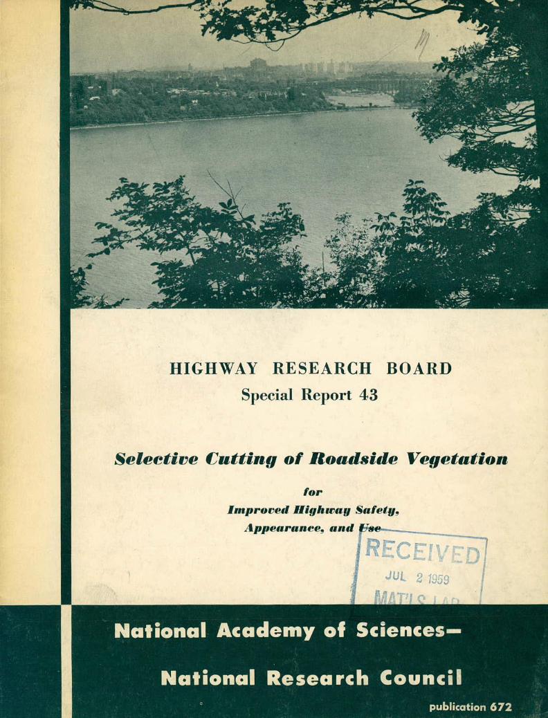
COVER PICTURE
View of Hudson River and Manhattan Island
from Palisades Interstate Parkway, New
Jersey, is framed in beautiful foliage by
selective cutting of roadside vegetation to
create a desirable vista.

Foreword
Very much as the engraver and the etcher cut away material to create a composition, so do the landscape architect and land-scape engineer create roadside pictures by cutting away trees and shrubs. Many timesthe composition is made on the job, in-spired by the imagination, artistry, and judgment of a trained mind and eye. Very few of these pictures have been described by text or drawing before their creation; not many of them have been described after their creation.
This report will have served its purpose if it speaks for the landscape architect and landscape engineer whose "roadside pictures" remain undocumented but expresses for them some of the principles and practices they have followed.
The principles described reflect a selection of the best from many good sources. Where practiced, they have withstood satisfactorily the scrutiny of man and the test of time. As used in this report, it is hoped that they may serve to guide, the work of those who are responsible for creating and maintain-ing safe, attractive, and useful roadsides.
Appreciation is exbended to those who have had an opportun-ity to plan and to record their work. For their contribution to this report, the author is greatly indebted.
Selective Cutting of Roadside Vegetation for Improved Highway Safety, Appearance and Use
The proper blending of many factors is necessary if a road is to serve satis-factorily the purposes for which it is intended. Factors such as adequate engineer-ing design standards that reflect complete analysis and correct interpretation of a road's funbtions; up-to-date construction practices with approved materials, and modern equipment; timely maintenance, repair, and improvement—all these contribute to the successful use of a traffic facility, whether that facility is a high-stan-dard multilaned, arterial expressway or parkway carrying a large volume of unre-stricted or selected types. of vehicles, or a low-standard, small-volume, all-pur-pose road winding its way through a desert canyon or a forested mountain.
The factors of a design, construction, and maintenance have certain tangible-, or texact,tt properties because they may be used in terms of mathematical formulas or tabulations, engineering principles or physical properties. For instance, there are definite relationships between vehicle speed, road grades, degrees of curvature, and superelevation; the sizes of ditches and drainage openings are determined from rate of precipitation, time, runoff area, and rate of flow; and the properties of steel, concrete, stone, wood, and other materials have been established within close limits.
However, a road that has been well designed, properly constructed, and ade-quately maintained from an engineering point of view may not be pleasant or safe to drive from another point of view. It is axiomatic that, within certain prescribed specifications, any vehicle may be propelled by any person along any road at any given speed, whatever the physical limits of the' considered factors of -design, con-struction, and maintenance may be.
But, up to this point, one other factor, a very important one, may not have been considered. It is one that can well determine whether a road is completely successful or merely adequate. It is the factor of driver behavior.
In considering the effect of highway design, construction, and maintenance, on driver behavior, one is concerned, largely, with intangibles. The social, physio-logical, and economic interrelationships of psychology, sensory perception, and emotional reaction are not, in themselves, exactitudes and cannot be stated with the same definitiveness that one can use in considering such exact sciences as math-ematics, physics, and chemistry. However, thoughtful 'study of the various elements of driver behavior as they relate to a road and its environs results in conclusions that can be resolved and applied in terms of specific design, construction and maintenance. An understanding of driver fatigue, for instance, results in an im-proved highway alignment that has shorter tangents and longer spirals in order to offset induced hypnosis and its resultant reflex lag. Driver safety is increased through the use of grade separations, limited access, and controlled ribbon develop-ments, which in turn retard 'highway obsolescence and result in increased community and regional economies and benefits. Safety and pleasure in driving are improved
1

2 SELECTIVE CUTTING OF ROADSIDE VEGETATION
through the use of trees, shrubs, and other materials as barriers for the reduction of headlight glare, the screening of objectionable roadside development, the dimin-ishing of traffic noises and distracting movements, and the reduction or diversion of winds and snow drifts. The selective thinning or removal of vegetation results in increased sight distance and safety at accesses and on curves and gives greater driving pleasure by creating vistas that enable the motorist to view and enjoy the special interests of the roadside along which he is traveling.
Each of the many components of driver behavior is deserv5'' of individual treatment, and for most of them considerable research has been done and much mater-ial written. Although selective cutting and removal of vegetation along roadsides has been practiced in some sections for many years, very little material has been written on the subject and not much of that material has been collected. It is in the special interest of this particular subject, "the selective cutting and removal of vegetation along roadsides," that this report has been compiled and written.
*
_ 1/LJJ
'
US 240, south of Hyattstown, Maryland, after selective cutting of vegetation. (Maryland State Roads Commission photo)
SAFErY: SIGHT DISTANCE ON CURVES AND INTERSECTIONS
Consideration of the selective removal of vegetation from roadsides should em-phasize two points of view: that of the driver of a car and that of his passenger. The driver is concerned, for the most part, in manipulating his vehicle, observing traffic control devices, and watching the behavior of other vehicles. His primary

SAFETY: SIGHT DISTANCE ON CURVES AND IW['ERSECTIONS 3
interest is in driving ease and in the safety and comfort of himself and his passen-ger, if any. He cannot afford to become preoccupied in the interest or attractions of the roadside. He recognizes and appreciates the use of these principles or de-vices employed in the design and construction of the road that have made the task of driving safer and more pleasant, even though he may not be able to identify or describe exactly what it is that has caused his driving to be less of a chore.
Until recently, not much thought or study had been given to this aspect of driver behavior. The comparatively new and greatly accelerating change in the transportation pattern—the development of powerful cars capable of high speed, an economy that enables more persons and enterprises to own more cars and to drive them more miles, and a resultant increase in traffic volume—has made highway engi-neers increasingly aware of the need for high-standard roads with all possible safety features. As circumstances require and permit, new roads are built to pre-determined standards and existing roads are reconstructed to improve standards.
On new roads, safety features are being "built in." A feature such as ade-quate sight distance on curves and at intersections has become an accepted element of good design. It is highly desirable that the driver of any vehicle, be able to see far enough ahead while rounding a curve or approaching an intersection to be able to bring his vehicle to a full safe stop if required. No tree, shrub, or other object should obscure his. vision. The physical dimensions of a desired sight dis-tance can be computed with reasonable accuracy through the proper use of certain known and assumed factors. These factors are road curvature, gradient, and super-elevation, vehicle speed and rate pf deceleration, and stopping distance. The first three—curvature, gradient, and superelevation—determine the speed of a car at any given point. The next two—vehicle speed and rate of deceleration—determine the distance required to bring the car to a full stop. Stopping distance determines sight-distance requirements.. Some research and experimentation in this phase of highway design have been made by traffic and highway organizations and some statis-tics have been published by them. The Institute of Traffic Engineers and the Na-tional Conservation Bureau have published jointly the "Traffic Engineering Hand-book," and the American Association of State Highway Officials has published "A Policy on Sight Distance for Highways." A Special Task Committee of the Roadside Development Committee, Highway Research Board, has collated much of the above ma-terial and published it in tabular form in "Special Report 23, Planning and Manage-ment of Roadside Vegetation, An Analysis of Principles, 196." Some of the tables and figures and portions of the text of "Special Report 23" have been reproduced for the purposes of this report.
TABLE 1
MAXIMIJM PROBABLE SPEEDS FOR VARIOUS CURVE RADII Curve Without With Curve Without With Radius, Superelev., Superelev., Radius, Superelev., Superelev., feet mph feet mph mph 100 33 34 BOO 5d 66 lO 36 39 900 59 67 200 41 44 1,000 . 68 20 42 . 47 ' 11100 60 69 300 44 49 1,200 60 70 350 47 52 1,300 60 71 400 ' 1,400 60 72
1,500 61 . 73 OO 52 59 15 600 62 74
600 54 62 1,700 64 7 - 700 6 6

SELECTIVE CUTTING OF ROADSIDE VEGETATION
TABLE 2
STOPPING DISTANCES FROM VARIOUS VELOCITIES AND AT VARIOUS DECELERATION RATES mph 12
mph/sec - 10 -
mph/sec mph/sec -
mph/sec 14
mph/sec 2
mph/sec feet feet feet feet feet feet
25 114 1145 150 165 19 270 30 170 17 190 210 245 360 35 200 210 225 20 30 LO 230 240 260 290 360 560 45 260 280 300 340 130 68 50 285 310 340 395 495 81 60 350 380 425 49 690 1,100 70 370 45 2O 620 820 i,Li±iO
Table 1, based on "Traffic Engineering Handbook," shows vehicle speed with re-lation to curves and superelevation. Because some drivers can negotiate curves at greater than the designed speed in some circumstances, speeds shown in the table are about 20 percent higher than in the referenced text, to include this "over-drive" ability.
Table 2, based on "Traffic Engineering Handbook" and "A Policy on Sight Dis-tance for Highways," shows basic time values given for mental perception and brak-ing reaction at certain initial vehicle speeds.
Table 3 shows that ascending or descending gradients in a road affect the rate of vehicle deceleration.
Sight distance is plotted from Tables 1, 2, and 3 as follows: From Table 1 select the maximum speed shown for a curve at a given radius; from Table 2 select the stopping distance required for the selected speed according to a selected rate of deceleration (adjusted to gradient from Table 3); plot the stopping distance along the line of travel on the curve; plot the chord between the beginning and end of the stopping distance. The sight-distance area is the area formed by the arc of the curve and the chord. The plotting of a succession of such chords will define the sight-distance zone within which.no tree, shrub, or other obstruction should be permitted.
If the limitation of planting zones by this method results in an uninterrupted and uninteresting planting outline, it may be possible to justify a few plants with-in the restricted zone in order to soften the outline. They should be scattered and few in number. Existing trees permitted to remain should be high-headed; their presence may cause no real •sight restriction until their trunks become large. In
TABLE 3
EFFECT OF GRADE ON STOPPING DISTANCES Assumed Upgrade - iJowngracie Design Decease in Increase in Speed Stopping Distance, feet Stopping Distance, feet
+3% +6% +9% -3% -6% -9% 30 - 0 -10 -10 + 0 +10 +10 40 -10 -10 -20 +10 +10 +20 50 -10 -20 -30 +10 +30 +40 60 -20 -30 -O +20 +LO +70 70 -30 -O -70 +30 +70 +120 -
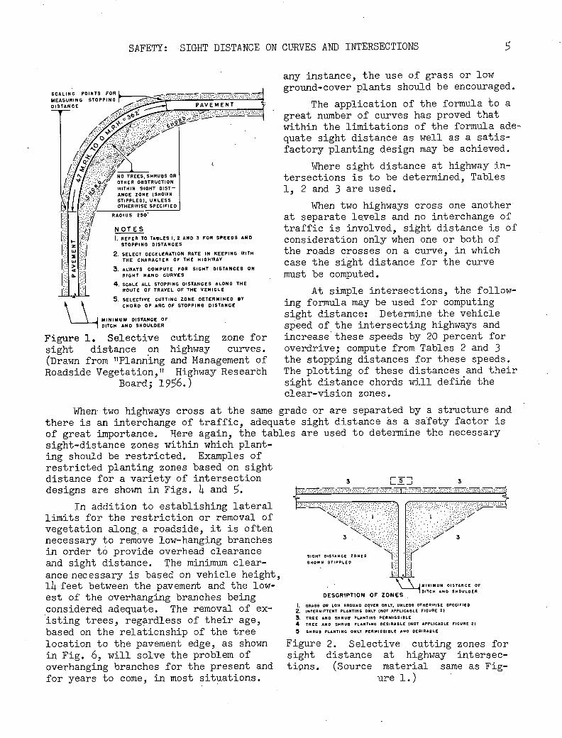
SCALING POINTS FOR MEASURING STOPPING DISTANCE
1 Itz NOTES I. REFER TO TABLES I, 2 AND 3 FOR SPEEDS AND
z STOPPING DISTANCES UU .I SELECT DECELERATION RATE IN KEEPING WITH
w .":' THE CHARACTER OF THE HIGHWAY
ALWAYS COMPUTE FOR SIGHT DISTANCES ON
G. RIGHT HAND CURVES
SCALE ALL STOPPING DISTANCES ALONG THE ROUTE OF TRAVEL OF THE VEHICLE
SELECTIVE CUTTING ZONE DETERMINED BY CHORD OF ARC OF STOPPING DISTANCE
J MINIMUM DISTANCE OF
1 DITCH AND SHOULDER
Figure 1. Selective cutting z.one for sight distance on highway curves. (Drawn from "Planning and Management of Roadside Vegetation,t' Highway Researbh
Board; 1956.)
SAFETY: SIGHT DISTANCE ON CURVES AND INTERSECTIONS
5
any instance, the use of grass or low ground-cover plants should be encouraged.
PAVEMENT T. The application of the formula to a great number of curves has proved that within the limitations of the formula ade-quate sight distance as well as a satis-factory planting design may be achieved.
NO TREES, SHRUBS OR OTHITHER OBSTRUCTION WIN SIGHT DIST ANCE ZONE (SHOWN STIPPLED). UNLESS OTHERWISE SPECIFIED
RADIUS 250
Where sight distance at highway in-tersections is to be determined'. Tables 15 2 and 3 are used.
When two highways cross one another at separate levels and no interchange of traffic is involved, sight distance is of consideration only when one or both of the roads crosses on a curve, in which case the sight distance for the curve must be computed.
At simple intersections, the follow-ing formula may be used for computing sight distance: Determine the vehicle speed of the intersecting highways and increase these speeds by 20 percent for overdrive; compute from Tables 2 and 3 the stopping distances for these speeds. The plotting of these distances and their sight distance chords will defire the clear-vision zones.
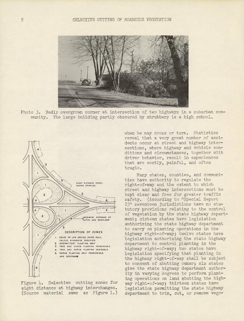
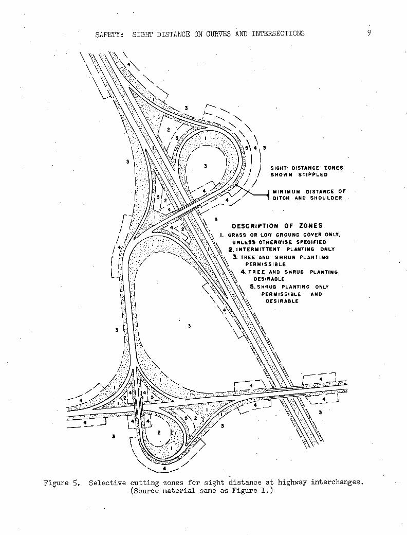
When two highways cross at the same grade or are separated by a structure and there is an interchange of traffic, adequate sight distance as a safety factor is of great importance. Here again, the tables are used to determine the necessary sight-distance zones within which plant- ing should be restricted. Examples of restricted planting zones based on sight distance for a variety of intersection 3 _j 3 designs are shown in Figs. 4 and 5.
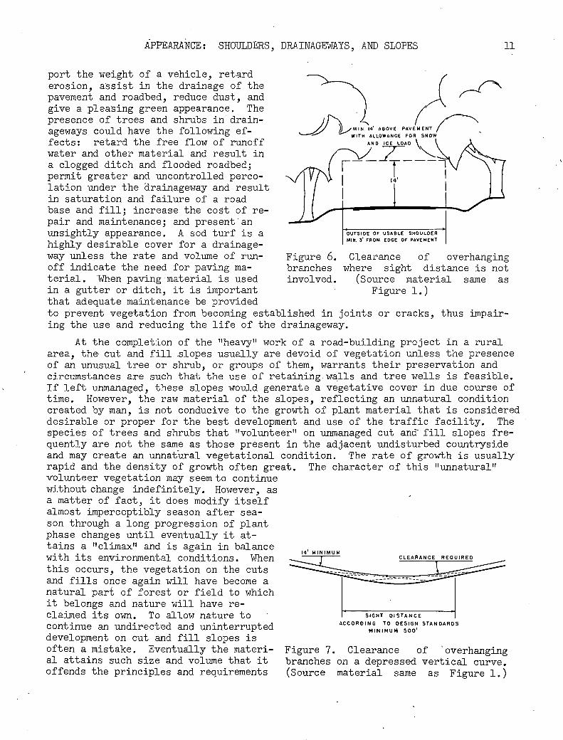
In addition to establishing lateral limits for the restriction or removal of vegetation along, a roadside, it is often necessary to remove low-hanging branches in order to provide overhead clearance and sight distance. The minimum clear-ance necessary is based on vehicle height, lii feet between the pavement and the low-est of the overhanging branches being considered adequate. The removal of ex-isting trees, regardless of their age, based on the relationship of the tree location to the pavement edge, as shown in Fig. 6, will solve the problem of overhanging branches for the present and for years to come, in most situations.
-'• :" ':' .'.' ...... '.', .' I
"' ": '
I ..
3 N. 3
SIGHT DISTANCE ZONES
SHGWN STIPPLES
MINIMUM DISTANCE OF
DESCRIPTION OF ZONES DITCH AND SHOULDER
I. GRASS OR LOW ORGUND COVER ONLY. UNLESS OTHERWISE SPECIFIED
2. INTERMITTENT PLANTING ONLY (NOT APPLICABLE FIGURE 2)
3, TREE AND SRRUW PLANTING PERMISSIBLE
4 TREE AND SHRAB PLANTING DESIRABLE (NGT APPLICAOLE FIGURE 2)
5 SRRUB PLANTING ONLY PERMISSIBLE AND DESIRARLE
Figure 2. Selective cutting zones for sight distance at highway intersec-tiQns. (Source material same as Fig-
ure 1.)

6 SELECTIVE CUTTING OF ROADSIDE VEGETATION
_J
SIGHT DISTANCE ZONES
SHOWN STIPPLED
MINIMUM DISTANCE OF
DITCH AND SHOULDER
DESCRIPTION OF ZONES
I. GRASS OR LOW GROUND COVER ONLY, UNLESS OTHERWISE SPECIFIED
INTERMITTENT PLANTING ONLY (NOT APPLICABLE FIGURE 3)
TREE AND SHRUB PLANTING PERMISSIBLE
TREE AND SHRUB PLANTING DESIRABLE (NOT APPLICABLE FIGURE 3)
SHRUB PLANTING ONLY PERMISSIBLE AND DESIRABLE
Figure 3. Selective cutting zones for .hf distance at hi hiu- , fl.T'Wr'-
Depressed vertical curves may also require the removal of branches to pro-vide overhead clearance and adequate sight distance. A method of determining sight distance under normal weather con-ditions is shown in Fig. 7. In some re-gions, consideration should be given to the removal of additional overhanging branches because of their sag under snow and ice loads. The extent of cutting to be done will be largely a matter of lo-cal determination and judgment. If such storms are moderate and infrequent, the motorist and adjacent property owner may prefer a temporary inconvenience to tra-vel rather than the loss of summer shade and coolness and other values.
Many roads traverse mountainous tions. (Source material same as Fig- ure 1
country having high scenic and other natural values. The design criteria for these roads, influenced by factors of
cost and importance or preserving natural values, usually require slower speeds, sharper curves, steeper grades, and narrower widths of pavement and shoulder than are normally indicated for other terrain. Very often these roads, with their ac-cesses and intersections, are first constructed in only their most essential form, such refinements as sight distance being added later. In such cases, the removal of plant material as a safety factor may be drastic and costly. Where sight-dis-tance requirements may be predetermined, included in the design of the road, and specified as part of the construction program, the selective removal of vegetation may be simpler and less costly.
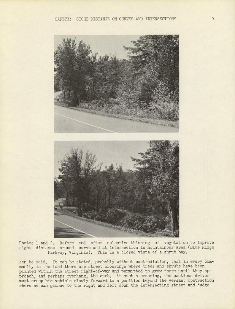
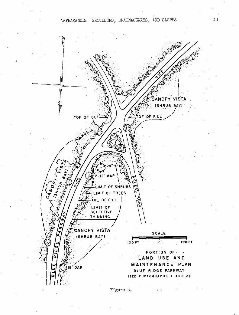
In building the Blue Ridge and Natchez Trace Parkways through Virginia, North Carolina, Tennessee, Alabama, and Mississippi, the National Park Service, Depart-ment of the Interior, has prepared and used Land Use and Maintenance Plans for the development of the roadsides in conjunction with the construction of the roadway. Sight distance on curves and at intersections has been incorporated in the plans for construction and maintenance. Figure 8 is a portion of a Land Use Plan showing the intersection of an access road with the Blue Ridge Parkway. At this particular site, the terrain and the existing access road determined the location of the in-tersection. The access road crosses the Parkway in the saddle of a ridge at a lo-cation tangent to the terminus of a tight spiral having a delta curve of 6 degrees 14.5 minutes. The roadway is two-lane, with a 20-ft pavement and 5-ft shoulders. It was essential that adequate sight distance be provided both on the curve and at the intersection. To achieve this, considerable vegetation had to be removed. All trees and shrubs were removed from the shoulder and shallow fill on the inside of the curve. Remaining vegetation within the sight-distance zone was selectively cut, with the cutting being heavy near the roads and progressively lighter back to-ward the maximum limits of the zone. The transition ranged from a complete clear-ing along the roadside to an undisturbed forest at the zone limits. Photograph 1 relates to FIg. 8 and shows the condition of this particular intersection before the removal of vegetation to improve sight distance. Photograph 2 illustrates the improvement after some of the plant material had been removed.
Sight distance at street. intersections in urban areas is another phase of traffic safety on which much that is critical and very little that is commendable
SAFETY: SIGHT DISTANCE ON CURVES AND INTERSECTIONS 7
Photos 1 and CO. Before and after selective thinning of vegetation to improve sight distance around curve and at intersection in mountainous area (Blue Ridge
Parkway, Virginia). This is a closed vista of a shrub bay.
can be said. It can be stated, probably without contradiction, that in every com-munity in the land there are street crossings where trees and shrubs have been planted within the street right-of-way and permitted to grow there until they ap-proach, and perhaps overhang, the curb. At such a crossing, the cautious driver must creep his vehicle slowly forward to a position beyond the verdant obstruction where he can glance to the right and left down the intersecting street and judge
8 SELECTIVE CUTTING OF ROADSIDE VEGETATION
ST :i
Z.
&1v ( ttW\ 1< 1
Photo 3. Badly overgrown corner aL inLorsection of two highways in a ourban com-munity. The large building partly obscured by shrubbery is a high school.
4 \
SIST DISTANCE ZONES
TC N
I:NOSHOULR
.//3
OESCRPTION OF ZONES
I. GRASS OR LOW GROUND COVER ONLY,
UNLESs OTHERWISE SPECIFIED
2. INTERMITTENT PLANTING ONLY
/
. TREE AND SHRUB PLANTING PERMISSIBLE
4 TREE AND SHRUB PLANTING DESIRABLE
\ 5, SHRUB PLANTING ONLY PERMISSIBLE
AND OESIRA9LJE
Figure L. Selective cutting zones for sight distance at highway interchanges. (Source material same as Figure 1.)
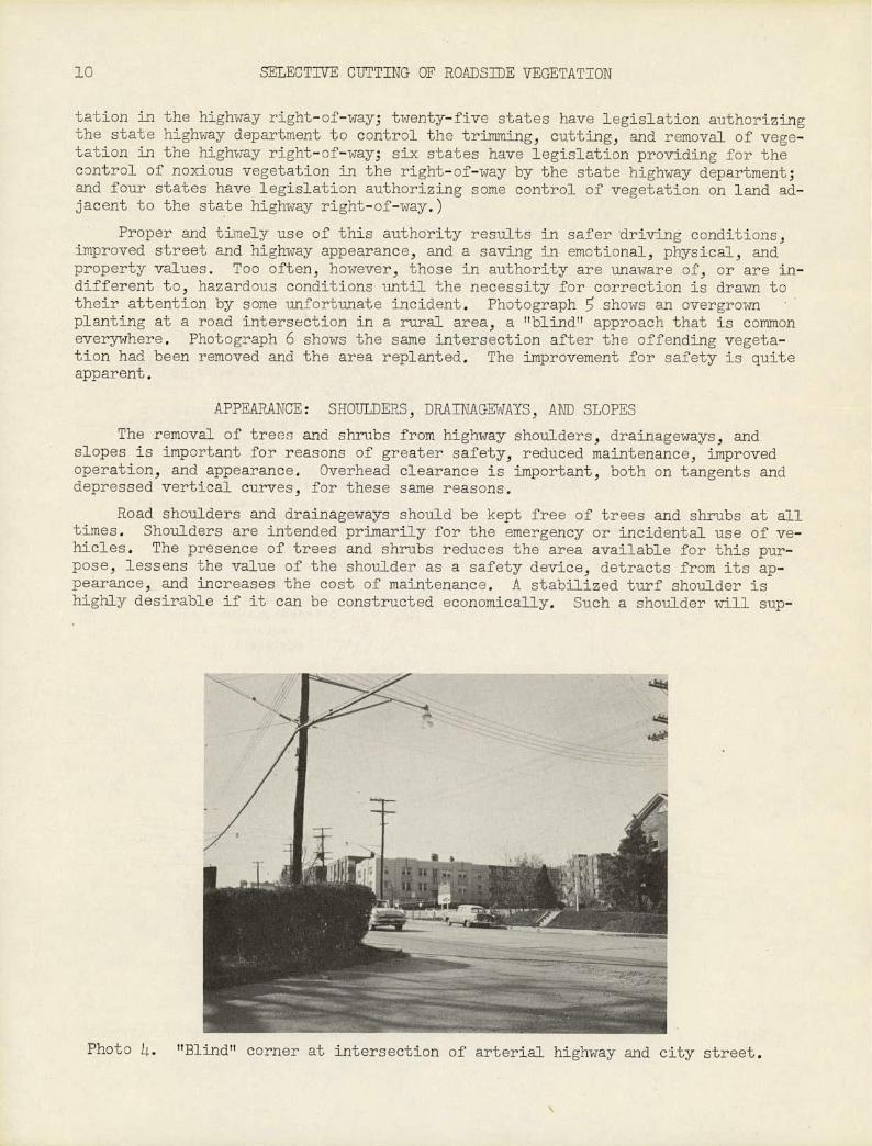
when he may cross or turn. Statistics reveal that a very great number of acci-dents occur at street and highway inter-sections, where highway and vehicle con-ditions and circumstances, together with driver behavior, result in experiences that are costly, painful, and often tragic.
Many states, counties, and communi-ties have authority to regulate the right-of-way and the ectent to which street and highway intersections must he kept clear and free .for greater traffic safety. (According to TTSpecial Report 23" seventeen jurisdictions have no sta-tutory provisions relating to the control of vegetation by the state highway depart-ment; sixteen states have legislation authorizing the state highway department to carry on planting operations in the highway right-of-way; twelve states have legislation authorizing the state highway department to control planting in the highway right-of-way; two states have legislation specifying that planting in the highway right-of-way shall be subject to consent of abutting owner; six states give the state highway department author-ity in varying degrees to perform plant-ing operations on land abutting the high-way right-of-way; thirteen states have legislation permitting the state highway department to trim, cut, or remove vege-
SAFETY: SIGHT DISTANCE ON CURVES AND INTERSECTIONS 9
SIGHT DISTANCE ZONES SHOWN STIPPLED
) N\ I
<4 c2\ \ DESCRIPTION OF ZONES
I GRASS OR LOW GROUND COVER ONLY,
I 1/ UNLESS OTHERWISE SPECIFIED
/ 47/ i \i \ 2. INTERMITTENT PLANTING ONLY
f 3 TREE AND SHRUB PLANTING
/ \ \ PERMISSIBLE
TREE AND SHRUB PLANTING
1• ::J \•:.. \:: ..\ DESIRABLE
1 . \:.. •.\ 5.SHRUB PLANTING ONLY
: PERMISSIBLE AND
DESIRABLE
Figure . Selective cutting zones for sight distance at highway interchanges. (Source material same as Figure i.)
13 SELECTIVE CTJTTING OF ROADSIDE VEGETATION
tation in the hihway right-of-way; twenty-five states have legislation authorizing the state highway department to control the trimming, cutting, and removal of vege-tation in the highway right-of-way; six states have legislation providing for the control of noxious vegetation in the right-of-way by the state highway department; and four states have legislation authorizing some control of vegetation on land ad-jacent to the state highway right-of-way.)
Proper and timely use of this authority results in safer driving conditions, improved street and highway appearance, and a saving in emotional, physical, and property values. Too often, however, those in authority are unaware of, or are in-different to, hazardous conditions until the necessity for correction is drawn to their attention by some unfortunate incident. Photograph 5 shows an overgrown planting at a road intersection in a rural area, a "blind" approach that is common everywhere. Photograph 6 shows the same intersection after the offending vegeta-tion had been removed and the area replanted. The improvement for safety is quite apparent.
APPEARANCE: SHOULDERS, DRAINAGEWAYS, AND SLOPES
The removal of trees and shrubs from highway shoulders, drainageways, and slopes is important for reasons of greater safety, reduced maintenance, improved operation, and appearance. Overhead clearance is important, both on tangents and depressed vertical curves, for these same reasons.
Road shoulders and drainageways should be kept free of trees and shrubs at all times. Shoulders are intended primarily for the emergency or incidental use of ve-hicles. The presence of trees and shrubs reduces the area available for this pur-pose, lessens the value of the shoulder as a safety device, detracts from its ap-pearance, and increases the cost of maintenance. A stabilized turf shoulder is highly desirable if it can be constructed economically. Such a shoulder will sup-
>r-'•"
Photo 4. "Blind" corner at intersection of arterial highway and city street.
APPEARANCE: SHOULDERS, DRAINAGEWAYS, AND SLOPES 11
port the weight of a vehicle, retard erosion, assist in the drainage of the pavement and roadbed, reduce dust, and give a pleasing green appearance. The presence of trees and shrubs in drain- (
Mh1 14 ABOVE PAVEMENT have the following ageways could ef- fects: retard the free flow of runoff
WITH ALLOWANCE FOR SNOW
AND ICE LOAD
water and other material and result in a clogged ditch and flooded roadbed; permit greater and uncontrolled perco- - lation under the drainageway and result in saturation and failure of a road base and fill; increase the cot of re- pair and maintenance; and present'an unsightly appearance. A sod turf is a OUTSIDE OF USABLE SHOULDER
highly desirable cover for a drainage- NUN. 3 FROM EDGE OF PAVEMENT
way unless the rate and volume of run- Figure 6. Clearance of overhanging off indicate the need for paving ma- branches where sight distance is not terial. When paving material is used involved. (Source material same as in a gutter or ditch, it is important Figure 1.) that adequate maintenance be provided to prevent vegetation from becoming established in joints or cracks, thus impair- ing the use and reducing the life of the drainageway.
At the completion of the "heavy" work of a road-building project in a rural area, the cut and fill slopes usually are devoid of vegetation unless the presence of an unusual tree or shrub, or groups of them, warrants their preservation and circumstances are such that the use of retaining walls and tree wells is feasible. If left unmanaged, these slopes would generate a vegetative cover in due course of time. However, the raw material of the slopes, reflecting an unnatural condition created by man, is not conducive to the growth of plant material that is considered desirable or proper for the best development and use of the traffic facility. The species of trees and shrubs that "volunteer" on uruiianaged cut and' fill slopes fre-quently are not the same as those present in the adjacent undisturbed countryside and may create an unnatural vegetational condition. The rate of growth is usually rapid and the density of growth often great. The character of this "unnatural" volunteer vegetation may seem to continue without change indefinitely. However, as a matter of fact, it does modify itself almost imperceptibly season after sea- son through a long progression of plant phase changes until eventually it at- tains a ttclimaxlt and is again in balance with its environmental conditions. When
MU! CLEARANCE REQUIRED
this occurs, the vegetation on the cuts and fills once again will have become a natural part of forest or field to which it belongs and nature will have re- claimed its own. To allow nature to SIGHT DISTANCE
continue an undirected and uninterrupted ACCORDING TO DESIGI STAN OAROS
development on cut and fill slopes is often a mistake. Eventually the materi- Figure 7. Clearance of 'overhanging al attains such size and volume that it branches on a depressed vertical curve. offends the principles and requirements (Source material same as Figure 1.)

12 SELECTIVE CUTTING OF ROI4DS]]JE VEGETATION
A- 17T
\ " \
)i
Photos 5 and 6. Before and after selec-tive removal of vegetation to improve sight distance at rural intersection. (Maryland State Roads Commission photos)
of safety and good appearance. The of-fending plants must be removed, trimmed, or otherwise controlled or managed in order to re-establish these principles and requirements. The proper introduc-tion, retention, or removal of plants on cut and fill slopes should be planned for in a manner that will achieve a desired effect quickly and keep construction and maintenance costs low. In some instances, during initial construction of a road and in the interest of economy, very large trees are allowed to remain on a construc-ted slope or close to the edge of a cut or fill. Environmental changes caused by construction activities may weaken these trees or cause them to die. Such trees constitute a hazard to property and peo-ple; where they exist near heavily used roads or public-use areas they should be removed. The post-construction removal of such trees is usually more costly than the cost of removal during initial con-struction of the road. Very often a po-tentially dangerous tree is not removed until wind, storm, or other action has sent it crashing dot-m across a road, per-haps damaging slopes, ditches, shoulders, and pavement, and obstructing as well as endangering traffic.
For the most part, it is highly de-sirable that cut and fill slopes be plant-ed to prevent erosion and improve appear-ance. The outer limits of the planting are usually defined by the somewhat regu-lar line of vegetation that remains at the top of a cut or the toe of a fill. The retention or introduction of plant materials within these zones should be governed to some exbent by the require-ments for sight distance and the need to blend the slopes with the adjacent vege-tation. Close to the road itself, where sight distance is important, all plant material within the sight-distance zone should be kept below the eye level of a motorist or should be so dispersed or sufficiently high-headed that the vision is not obstructed. Where cut and fill slopes occur in an unbroken forested area, the size and density of vegetation on the slopes may become progressively greater as the distance from the roadway iricreas-es. Where shrub bays or woodland meadows
APPEARANCE: SHOULDERS, DRAINAGEWAYS, AND SLOPES 13
Go
) /*CANOPY VISTA
, f \ (SHRUB7Y)
TOP OF CUT ) /TO.E OF FILL.'
o /
- • *24 HEM.'
/ / ç LiMIT OF SHRUBS \cn\
I •7J,/// /tTr_LIMITOF TREES \\
QTOEOFFILLJ \\ LIMIT OF
..•f /.I jk'1. - SELECTIVE /
// CANOPY VISTA ..4:.
//.f*(sHRuB BAY) SCALE I
1w! 100 FT 0 100 FT
'?b III :/ ••
PORTION OF LAND USE AND
ia OAK
MAINTENANCE PLAN
-j BLUE RIDGE PARKVAY
I •.: (SEE PHOTOGRAPHS I AND 2)
Figure 8. .
/
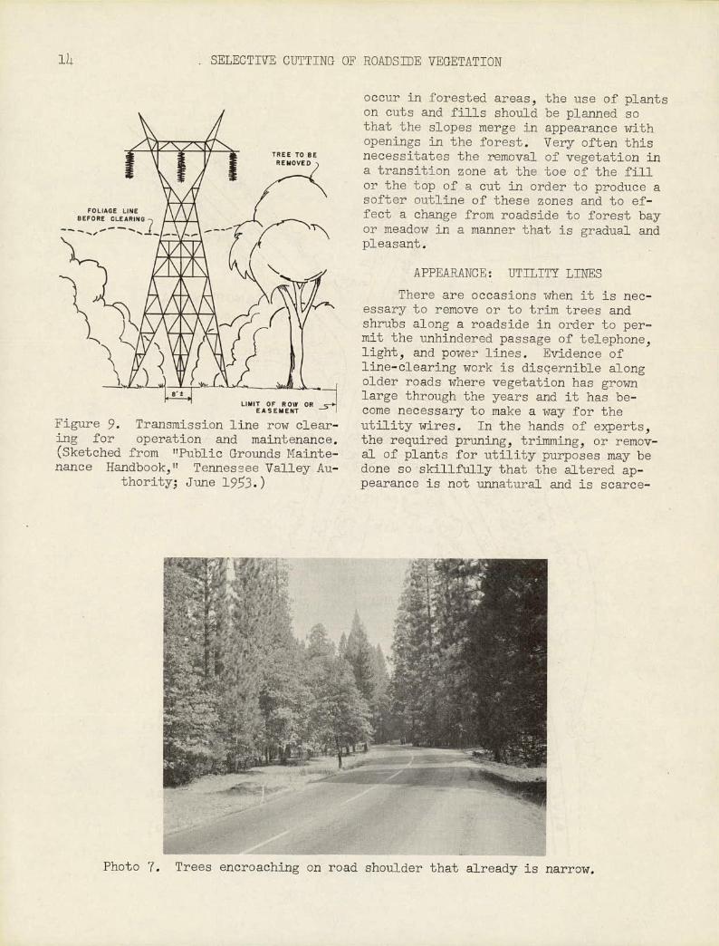
Figure 9. Transmission line row clear-ing for operation and maintenance. (Sketched from "Public Grounds Mainte-nance Handbook," Tennessee Valley Au-
thority; June 193.)
11 SELECTIVE CUTTING OF ROADSIDE VEGETATION
:.,
occur in forested areas, the use of plants on cuts and fills should be planned so that the slopes merge in appearance with openings in the forest. Very often this necessitates the removal of vegetation in a transition zone at the toe of the fill or the top of a cut in order to produce a softer outline of these zones and to ef-fect a change from roadside to forest bay or meadow in a manner that is gradual and pleasant.
APPEARANCE: UTILITY LINES
There are occasions when it is nec-essary to remove or to trim trees and shrubs along a roadside in order to per-mit the unhindered passage of telephone, light, and power lines. Evidence of line-clearing work is discernible along older roads where vegetation has grown large through the years and it has be-come necessary to make a way for the utility wires. In the hands of experts, the required pruning, trimming, or remov-al of plants for utility purposes may be done so skillfully that the altered ap-pearance is not unnatural and is scarce-
-
Photo 7. Trees encroaching on road shoulder that already is narrow.
APPEARANCE: UTILITY LINES
15
ly noticed. Done by the novice or the careless, the results may be grotesque.
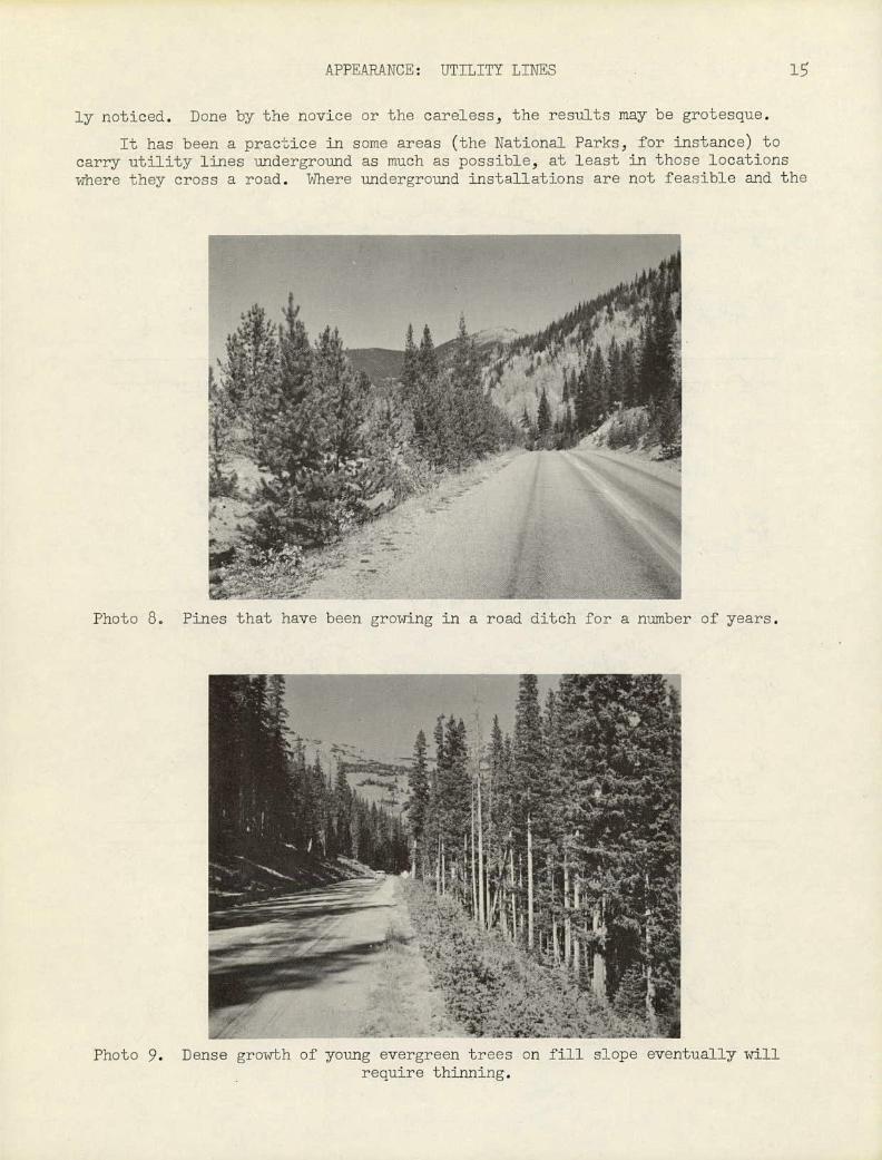
It has been a praciice in some areas (the National Parks, for instance) to carry utility lines underground as much as possible, at least in those locations where they cross a road. Where underground installations are not feasible and the
MORDWIF Pines that have been growing in a road ditch for a number of years.
Photo 9. Dense growth of young evergreen trees on fill slope eventually will require thinning.

W 0 0 D S
J1BNG POTENTIAL VISTA OF VALLEY OR LAKE, ETC. FROM HIGHWAY
16 SELECTIVE CUTTING OF ROADSIDE VEGETATION
- HIGJ1VAY
H I . JUV A ( - -'
V R 0 N G MOVING VISTA AT 90° ANGLE N
3 FROM HIGHWAY IS HAZARDOUS
RIGHT
Lliz
L..
'2 MOVING VISTA AT NOT TOO WIDE AN ANGLE FROM DIRECTION OF TRAVEL
TURNOUT 4..
R I G H T STATIONARY VISTA AT YIDE ANGLE WITH PARKING TURNOUT PROVIDED
Figure 10.

TTS
17
Photo 10. Young pine trees on fill slope on curve are reducing sight distance and closing in vista of meadow.
lines are carried overhead, the crossing of a road should be :t right angles to the road, with the poles or towers as far apart as practicable; tIus the motorist is aware of the presence of the lines for as short a space of tite as possible.
In all instances where a utility line is located close t a road, either par-alleling it or crossing it, overhead or underground, the remcal or thinning of trees and shrubs within the utility-line easement can follow a definite and desir-able pattern. Only enough vegetation should be removed near the center of the easement to permit the free and clear passage of the lines and the progress of maintenance personnel and equipment. This passageway from pole to pole, or tower to tower, is not necessarily a straight line; it may be somewhat indirect because of topography and ease of access. Clearing operations, particularly on slopes, should be conducted in a manner that will avoid erosion. It is desirable to main-tain a low ground cover over the entire central area of the clearing. From this area outward to the limit of the easement, the selective removal of trees and shrubs should be progressively less, so that a transition is developed from the heavy clearing in the center to the limited clearing at the edge. All trees that could foul the conductors in falling should be removed. Maintenance should be pro-vided on a 3- to b-year interval. Trees and shrubs that are not expected to reach a dangerous height within this period need not be removed.
USE
Today's highway is more than just a facility designed to move cars, commerce, and people quickly from one place to another. 1t has other purposes. It endeavors to make that trip from here to there as safe, as restful, as diversified, and as interesting as possible. It encourages the motorist to use the road for reasons other than simply travel by adding such features as parking turnouts, rest areas, and wayside parks. / It calls attention to historic events and to natural or other
i/Ttparking Areas and Rest Turnouts. Highway Research Board, Special Report 7 (192).

-
RIGHT. VISTA AT NOT TOO
WIDE AN ANGLE FROM
DIRECTION OF TRAVEL
18 SELECTIVE CWJ1TING OF ROADSDE VEGETATION
SIGN
_ 5 WRONG. VISTA FRO APPROACH A ND ON CURVE IS HAZARDOUS
\VRONG. VISTA FROM
CURVE APPROACH (VARNING SIGN ZONE) AND ON CURVE
IS HAZARDOUS
- \VRONG. VISTA AT 90 ANGLE
FROM HIGHWAY IS HAZARDOUS
:
SIGN
a/SIGN /••.•.
RIGHT ..:VISTA COMPLETED
BEFORE PASSING
2: YARNING SIGN ON CURVE APPROACH
Figure 11.

USE
\VI NDTHRO\V TREES GROWING IN EXPOSED LOCATIONS ARE ADAPTED TO STRONG WINDS. THEY SHOULD NOT BE REMOVED IF THEY FORM A, BUFFER AREA PROTECTING TREES THAT ARE LESS STABLE
SUSCEPTIBILITY TO YINDTHROW VARIES ACCORDING TO SPECIES OF TREE (MANY CONIFERS ARE SHALLOW-ROOTED), AGE
AND CONDITION OF STAND OF TREES, AND TOPOGRAPHIC AND OTHER SITE FACTORS,
RIGHT0 VISTA AT NEARLY 900 ANGLE TO STRONG WINDS
TREES SUSCEPTIBLE TO WINDTHROW -
....... - '
TURNOUT
./ ESTABLISHED TREES ADAPTED TO STRONG
\.'.iWIND EXPOSUREj..)
VRONG STRONG WINDS THR FUNNEL CREATED BY VISTA MAY TOPPLE TREES ACROSS HIGHVAY
\Y R ON G TREES EXPOSED EXISTING POTENTIAL VISTA ON HILL MAY BE UPROOTED BY STRONG WINDS OF VALLEY, LAKE, ETC.
1 PREVAILING DIRECTION OF STRONG \VIN DS
Figure 12.
PUBLIC ROAD
0 3
PUBLIC
S LIMIT OF
NATURAL REFORESTATION \
AREA To BE KEPT OPEN BY
•
,,z • i:: l EXISTING
FORES
E.
TS
UI -
U. S. DEPARTMENT OF THE INTERIOR
\ - NATIONAL PARK SERVICE
\ PORTION OF
\ 0 LAND USE AND MAINTENANCE PLAN
b - NATCIIEZ TRACE PARKVAY
S. SCALE
0 00 z6cr 300
Figure 13.
OR

USE
21
Photo 11. Wind-thrown sequoia that fell across road has been cut up and moved to one side pending further disposal. Sequoia National Park, California.
..; .......-.'_ -
-
-• ---
T -- I,.- -
47
Photo 12. Sequoia thrown by eroding slope caused considerable road damage. it was pulled downslope to become part of forest floor. Sequoia National
California.
Later, Park,
phenomena by means of wayside signs, exhibits, or museums. It develops interest in its alignment by merging with the forests and deserts, blending with the meadows and fields, and creating vistas to points or areas of special attraction.
22 SELECTIVE CUTTING OF ROADS]]JE VEGETATION
Photo 13. First stage of pruning for line clearance. (Asplundh Tree Expert Co photo)
Wherever the characteristics of a roadside indicate the desirability of con-structing special devices or creating special effects, the treatment of plant ma-terials becomes important.
OPEN V I S T A
REMOVE
\ CEDAR
REMOVE
FIR (
OAK
S C A L E Z \' 0 THIS VISTA IS 0.5 MI.
EAST OF PARKING AREA 50 0
1 50 100 - AT WAWONA TUNN EL
0
Figure 14. Vista of Bridalveil Falls below Artists Point, Yosemite National
Park, California.
A parking turnout, essentially an exiension of a traffic surface, may sim-ply provide the driver of a car or truck a place to rest and relax for a time. It may or may not be separated from the primary trafficway by a narrow median or wide island. If a narrow median is to be planted, the plants should be limited to the low-growing ground-cover variety for reasons of sight distance and protec-tive surveillance. If a wide island has been or can be developed without the des-truction of existing trees and shrubs, the existing vegetation should be thinned sufficiently to embody the best princi-ples of sight distance, appearance, and use. A turnout for parking alongside a sign, marker, interpretive device, or other structure should be given the bene-fit of a designed setting which presents the area to its best advantage. If the plant materials already exist, enough plants should be removed so that atten-tion is directed to the center of inter-est and at the same time have the area 11tie in" with its surroundings. Very
USE
23
Photo 1'.. TJiddle ag pr:ning opc::'aticn shown in Photo
Photo 15. Final Stage or pruning operation shown in Photo 13.
often a turnout provides parking at an area of special interest or at an outstand-ing vista. The special interest of such an area may be a nearby, relatively narrow view of a waterfall, rock ledge, or shrub bay; or it may be a distant, sweeping panorama of a mountain, lake, or valley. The landscape and planting design of each subject should be determined according to its own requirements. It may mean the selective removal of relatively few plants within a confined space or the almost mass removal of many plants over a large area.
21i SELECTT\TE CUTTING OF ROADSIDE VEGETATION
Rest areas and wayside parks adjacent to a roadside provide not only parking space for vehicles but facilities for general public use of the area, such as water, tables, benches, fireplaces, toilets, walks, and so forth. Such areas and parks are located where they will offer the most benefits to the traveler. They are of-ten a number of miles from copulated areas, on sites that are not larger than a few acres in size, where ample shade and water are available and where scenic quality or other features are worthy of development and conservation. The site development of each area or park should be considered according to its own merits. If some clearing of the site is required, enough lants should be removed so that a some--what "open1' aspect is achieved, thus making sinpler the problems of administration, protection, and maintenance. If clearing is desired to open a line view, periodic pruning and selective thinning may be necessary in order to maintain that view.
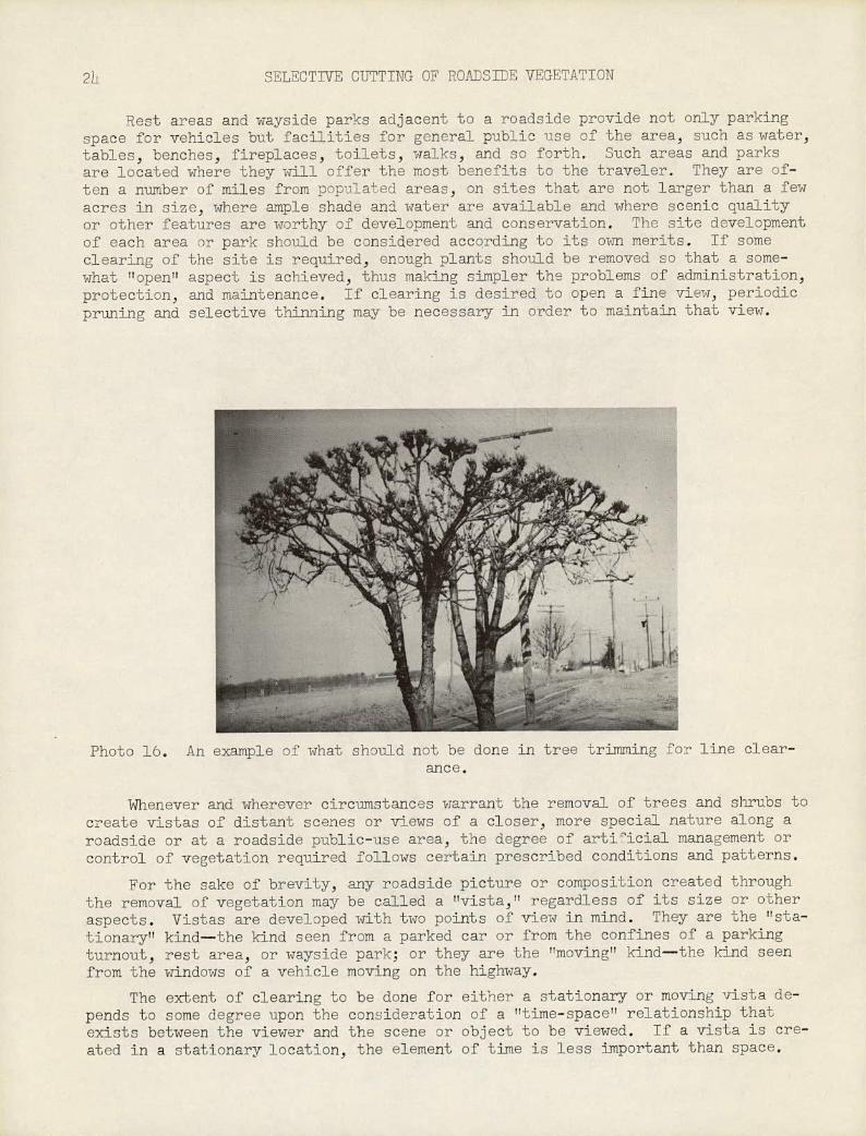
Photo 16. An ::.:uip1 ha'L should not be done in tree trimming for line clear- an cc.
Whenever and wherever circumstances warrant the removal of trees and shrubs to create vistas of distant scenes or views of a closer, more special nature along a roadside or at a roadside public-use area, the degree of artiicial management or control of vegetation required follows certain prescribed conditions and patterns.
For the sake of brevity, any roadside picture or composition created through the removal of vegetation may be called a "vista," regardless of its size or other aspects. Vistas are developed with two points of view in mind. They are the "sta-tionary" kind—the kind seen from a parked car or from the confines of a parking turnout, rest area, or wayside park; or they are the "moving" kind—the kind seen from the windows of a vehicle moving on the highway.
The ecLent of clearing to be done for either a stationary or moving vista de-pends to some degree upon the consideration of a "time-space" relationship that exists between the viewer and the scene or object to be viewed. If a vista is cre-ated in a stationary location, the element of time is less important than space,
'
USE 2
The observer is not concerned with brevi;y of time but is interested in the charac-teristics of the vista. He may remain in his parked car or get out and walk around, usually within a short distance from the car. There may be only one narrow view, necessitatind the removal of relatively few trees and shrubs; or there may be sev-eral views, varied in ecent and requiring more clearing, depending upon the move-ment of the observer. Generally, the clearing required for a stationary vista is auite selective and conservative because the observer has more time to see and to study the scenes or objects called to his attention. In a moving vista, time is as important as space and the planning for both should relate directly to the ve-hicle operator's viewpoint. This is important for safety reasons. Automobile ac-cidents often are reported as being caused by the momentary diversion of a driver's attention to a scenic attraction or object along the roadside. Very often, the un-
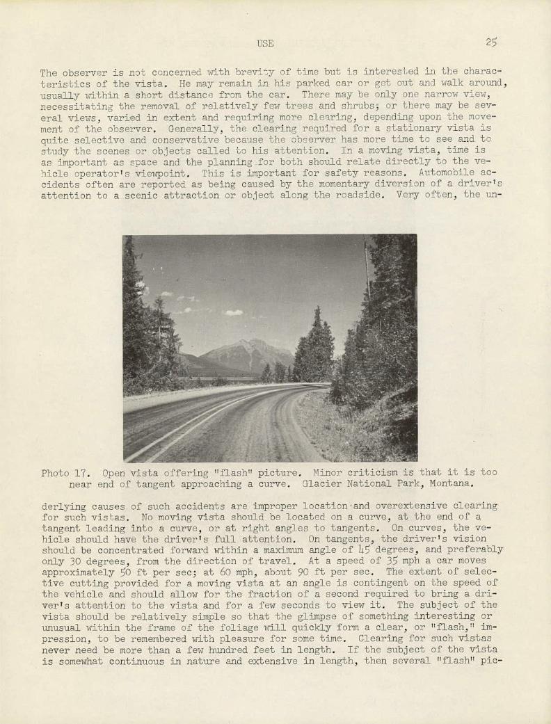
Photo 17. Open vista offering 'tflash" picture. Itinor criLicism is that it is too near end of tangent approaching a curve. Glacier National Park, Montana.
cierlying causes s.fl such accidents are improper location and overextensive clearing for such vishas. No moving vista should be located on a curve, at the end or a tangent leading into a curve, or at right angles to tangents. On curves, the ve-hicle should have the driver's full attention. On tangents, the driver's vision should be concentrated forward within a maximum angle of h15 degrees, and preferably only 30 degrees, from the direction of travel. At a speed of 35 mph a car moves approximately 50 ft per see; at 60 mph, about 90 ft per sec. The extent of selec-tive cutting provided for a moving vista at an angle is contingent on the speed of the vehicle and should allow for the fraction of a second required to bring a dri-ver's attention to the vista and for a few seconds to view it. The subject of the vista should be relatively simple so that the glimpse of something interesting or unusual within the frame of the foliage will quickly form a clear, or "flash," im-pression, to be remembered with pleasure for some time. Clearing for such vistas never need be more than a few hundred feet in length. If the subject of the vista is somewhat continuous in nature and extensive in length, then several "flash" pie-

26 SELECTIVE CUTTING OF ROADSE VEGETATION
Photos 18 and 19. Before and after selective cutting for angled "flash's vista along Merced River, Yosemite National Park, California.
tures may be provided at intervals within the, same vista area. If the nature of the vista suggests that it should be cleared for more than several hundred continu-ous feet of its length, then it has passed beyon'd consideration as a moving vista and should be considered a stationary vista, with a parking turnout or other stop-ping place provided.
In addition to conditions described above, clearing for vistas depends to some extent upon the nature of existing vegetation and the direction of prevailing winds.
USE 27
For forest protection, the cutting of vistas should be undertaken with great care. The susceptibility of trees to being wind-thrown varies with their species, with age, with the condition of the forest stand, and with topographic, soil, and other site conditions. Trees growing in a closed stand may be destroyed if an opening made in the stand exposes some of the trees to wind action. Selective cutting should be planned so that vista openings will not expose unstable trees, particu-larly at the ends of long clearings. The shaping of vistas that will create a tun-nel for wind should be avoided. As often as possible, clearing for vistas should be done at right angles to the direction of the prevailing wind in order to reduce the possibility of wind-thrown trees.
Vistas may be classified in three general types, from the standpoint of the pattern of their clearing: open, closed, and canopy.
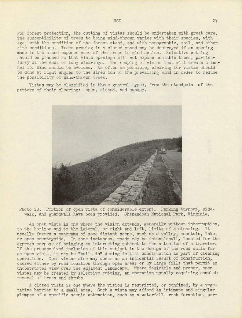
Photo 20. Portion of open vista of considerable extent. Parking turnout, side-walk, and guardwall have been provided. Shenandoah National Park, Virginia.
An open vista is one where the vision extends, generally without interruption, to the horizon and to the lateral, or right and left, limits of a clearing. It usually favors a panorama of some distant scene, such as a valley, mountain, lake, or open countryside. In some instances, roads may be intentionally located for the express purpose of bringing an interesting subject to the attention of a traveler. If the preconceived inclusion of this subject in the design of the road calls for an open vista, it may be "built in" during initial construction as part of clearing operations. Open vistas also may occur as an incidental result of construction, caused either by road location through open areas or by large fills that permit an unobstructed view over the adjacent landscape. Where desirable and proper, open vistas may be created by selective cutting, an operation usually requiring complete removal of trees and shrubs.
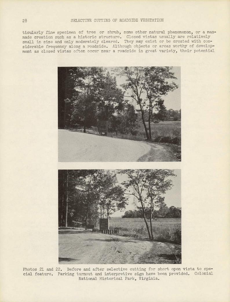
A closed vista is one where the vision is restricted, or confined, by a vege-tative barrier to a small area. Such a vista may afford an intimate and singular glimpse of a specific scenic attraction, such as a waterfall, rock formation, par-
28 SELECTDTE CUTTING OF ROADSIDE VEGETATION
ticularly fine specimen of tree or shrub, some other natural phenomenon, or a man-made creation such as a historic structure. Closed vistas usually are relatively small in size and only moderately cleared. They may exist or be created with con-siderable frequency along a roadside. Although objects or areas worthy of develop-ment as closed vistas often occur near a roadside in great variety, their potential
Photos 21 and 22. Before and after selective cutting for short open vista to spe- cial feature. Parking turnout and interpretive sign have been provided. Colonial
National Historical Park, Virginia.

USE
29
Photos 23 and 214. Site of an open vista before and after selective cutting to open up the view to Bridalveil Fall. Yosemite National Park, California.
interest often is overlooked and neglected. The selective cutting and cleanup re-quired for closed vistas must be done very carefully and with much imagination. (See Photographs 1 and 2.)
A canopy vista may be either an open or closed vista that is framed overhead by trees close to the road or close to the observer. The line of vision is through and under the trees and may be wide or narrow, as circumstances indicate. Often the more attractive and less expensive of the vistas, it should be given special
NO FENCE OR CULTIVATION ENCROACHMENT AFTER I CONSTRUCTION OF DUAL .-I5 -j 55 5'
PAVEMENT jx VEGETATION IN THIS.AREA TO BE PRESERVED UNTIL DUAL CONSTRUCTION
MAXIMUM UTILITY CLEARING AREA
LOW-GROWINGI MAXIMUM FENCE OR CULTIVATION PLANTS TO BE I ENCROACHMENT PENDING DUAL CONSTR'N PRESERVED
200 ROW
60
0 cc
82 VEGETATION IN THIS AREA TO BE PRESERVED
UNTIL DUAL CONSTRUCTION
w
60 ROW 100' ROW NO NEW TREES TO BE
A I
PLNTED ON ROW
EXIST INGT
TREE AREA
REES NAY 18' 20' I2'
REMAIN UNLESS A ON LOW-GROWING PLANTS HAZARD IF UTILITY LINE EXISTS
30 • 50 NO FENCE OR CULTIVATION ENCROACHMENT
-I-. MAXIMUM ON SPECIAL HIGHWAYS UTILITY CLEARING AREA ISO' ROW
LOW-GROWING (DUAL PAVEMENT) PLANTS TO BE MAXIMUM FENCE OR CULTIVATION
PRESERVED ENCROACHMENT PENDING DUAL CONSTR'N ¶ 'Z,.4.-6O' I
TREE AREA 4. NO FENCE OR CULTIVATION E NCROACHMENT 27' 12 - 20 - - -.-.. I6'
MAXIMUM 75. UTILITY
F CLEARING AREA
LOW-GROWING PLANTS TO BE'
(LRESERVED II
60'
MAXIMUM FENCE OR
-i'TREE AREA CULTIVATION ENCROACHMENT 12 4. 20' 28' "I- 13'
4.MAXIMUN I +UTILITY I IF SERVICE ROADS ARE BUILT ON A 200' ROW, ALL TREE AREAS WILL BE ELIMINATED
CLEARING I AREA I
260' ROW PRESERVATION MAXIMUM FENCE OR CULTIVATION (ALSO APPLICABLE TO 250' ROW
OF LOV-GROW'GI ENCROACHMENT PENDING DUAL CONSTR'NPLANTS OPTN)L
c~ L~f_
I
TREE
t _VEGETATION IN THIS AREA TO BE PRESERVED
UNTIL DUAL CONSTRUCTION
130 130' -
THIS VEGETATION IN AREA TO BE PRESERVED VEGETATION IN THIS AREA TO BE PRESERV UNTIL SERVICE ROAD IS BUILT UNTIL SERVICE ROAD IS BUILT
Drawn from STANDARDS FOR ROADSIDE VEGETATION AND ENCROACHMENTS prepared by NORTH CAROLINA STATE HIGHWAY AND PUBLIC WORKS COMMISSION, 3-55
Figure 1.
MAXIMUM UTILITY 150' ROW CLEARING AREA
(SINGLE PAVEMENT)61 T :
BE
C I LOW-GROWINGI NTS TO PLA I
'.IPRESERVED I
60'_' MAXIMUM FENCE OR
CULTIVATION ENCROACH- MENT
15'-
ONLY LOW-GROWING PLANTS IF UTILITY LINE EXISTS
UTILITY :
MAXIMUM FENCE CLEARING
. OR CULTIVATION AREA
ENCROACHMENT
PENDING SERVICE PRESERVATION
\ ROAD CONSTRUCTION OF LOW-GROW'G PLANTS OPT1'L
Ii 43-
U) t-rJ
H
It
H H
Q
0
Cl) H
txj
LrJ
H
H H 0
li

CONSTRUCTION AND MAINTENANCE 31
consideration. At the site of a canopy vista, the understory of shrubs and small trees should be removed and the remaining stand of trees should be thinned or primed. The trees that are left should form a canopy, moderately high-headed, that will enable one to look under and through the trees to the vistaTs subject of in-terest. The removal of vegetation should not be too thorough and the cutting should be careililly studied to determine how a transition may be developed from the center to the limits of clearing and what plant material should be retained.
CONSTRUCTION AND MAINTENANCE
Considerable care and judgment must be exercised when removing trees and shrubs during construction and maintenance operations. The work to be done should be given the benefit of the professional knowledge and experience of such persons as the landscape architect, highway engineer, forester, agronomist, naturalist, and others. There should be close communication and cooperation between all professionals, and the interests of each one should be blended with those of each other for the suc-cess of a project as a whole.
It is easy to remove vegetation. It is difficult and costly to replace plants when their removal has been made in error or has created a condition requiring cor-rection beyond the intended purposes of the clearing. For instance, the develop-ment of a site for an open vista could create conditions that would cause land ero-
.
Photos 2 and 26. Site oV a canopy vista before and after selective cutting of trees and shrubs. Skyline Drive, Shenandoah National Park, Virginia.
OF FIL C-% Z Y2S..
CULVERT\'9 T V
TIPICAL(VA6'EA FOR TURAL REFORESTATION
ROPIN
2STONE-PAVED GUTTER TYPICAL NATURAL REGENERATION I
.MOWING SHRUB1
TYPICAç4IATURAL WOODED AREA' AND SHRUB BAY
- 20OAK'
EXISTING DECIDUOUS WOODS
ROCK OUTCROP (UNSTABLE)
AGEJ \ V2ROIK OUTCROP (SOLID)
10 TYPICAL AREA TO BE KEPT
16
VISTA OVER FOLIAGE / Jff/4 VISTA AT EDGE .
' i
OF FOLIAGE
TYPICAL'AREA CONTROLLED\°o BLACKTOP WALK 'Vc'/7V/' BY SPECIAL USE PERMIT \ WITH STONE CURB ç-J//,, OR SCENIC EASEMENT \
00' 0' ,00V - *od 30 *00 500 PITT
SCALE
U. S. DEPARTMENT OF-THE INTERIOR NATIONAL PARK SERVICE
PORTION OF PROPOSED
ROADS AND TRAILS MAINTENANCE PLAN
BRUSH-CLEARIG LINE,5 j
7 1 OPEN WOODS
MILE POST- \'.
\
MIXED DECIDUOIJ AND EVERGREEN
WOODS
VISTA THRU (CANOPY
TYPICAL CROSS-SECTIONS
)'Th PROPOSED WOODS
TO BE
WOO(
ING
,1 PROPOSED WOODS )J BRID
PLAN INTERPRETATION
RIVERS AND
/ \\
EXISTING WOODS
MOWING LIMITS FOR REFORESTED AREAS
EXISTING OODS
TO BE MOWED I I TO BE MOWED (VARIABLE) I ROAD SURFACE I (VARIABLE)
H i EXISTING WOODS I I
MOWING LIMITS FOR NATURAL WOODED AREAS & SHRUB BAYS
TOBE ) PARKING WIDENING TO BE MOWED LIMIT OF PASTURE LIMIT OF VISTA MOIVED ' OR OVERLOOK (VARIABLE) - OR CULTIVATION
(VAR.)',) V V
J
VISTA THROUGH FOLIAGE (CANOPY VISTA) NOTE: TREE AMC) SHRUB AREAS TO BE THINNED AND
VER FOLIAGE V TO BE EDGE OF TREE LINE • UNLESS OTHER-
VISTA AT EDGE OF FOLIAGE CLEARED OF BRUSH PERIODICALLY TO KEEP VISTA LINES OPEN. BRUSH CLEARING LIMIT
V. (OPEN VISTA) WISE SHOWN.
MOWING AND CUTTING LIMITS FOR VISTAS AND LEASED AREAS
IOV AV ,PV ZOV - 30V id 59 PelT
SCALE
Figure 16.
CONSTRUCTION AND MAINTENANCE 33
sion and plant damage through lack of consideration of such factors as degree of slope, type of soil, amount of moisture, type of drainage, and exposure to sun and wind. The analysis of these and other factors by qualified persons prior to or during early stages of road construction and roadside development could result in a modification or elimination of a proposed clearing project.
As often as possible, the removal of vegetation for roadside vistas and other purposes should occur with the construction of the road. Roadside-development aims and needs should be studied and plans and specifications prepared beforehand, if at all practicable. Such plans should describe the work to be done during construc-tion and should set the pattern to be followed later by maintenance. Land Use and Maintenance Plans prepared for the )477-mile-long Blue Ridge Parkway and the ljO-mile-long Natchez Trace Parkway have been in continuous use ever since the first construction contract was let in 193. A portion of one of these maps is repro-duced in this report (Fig. 13).
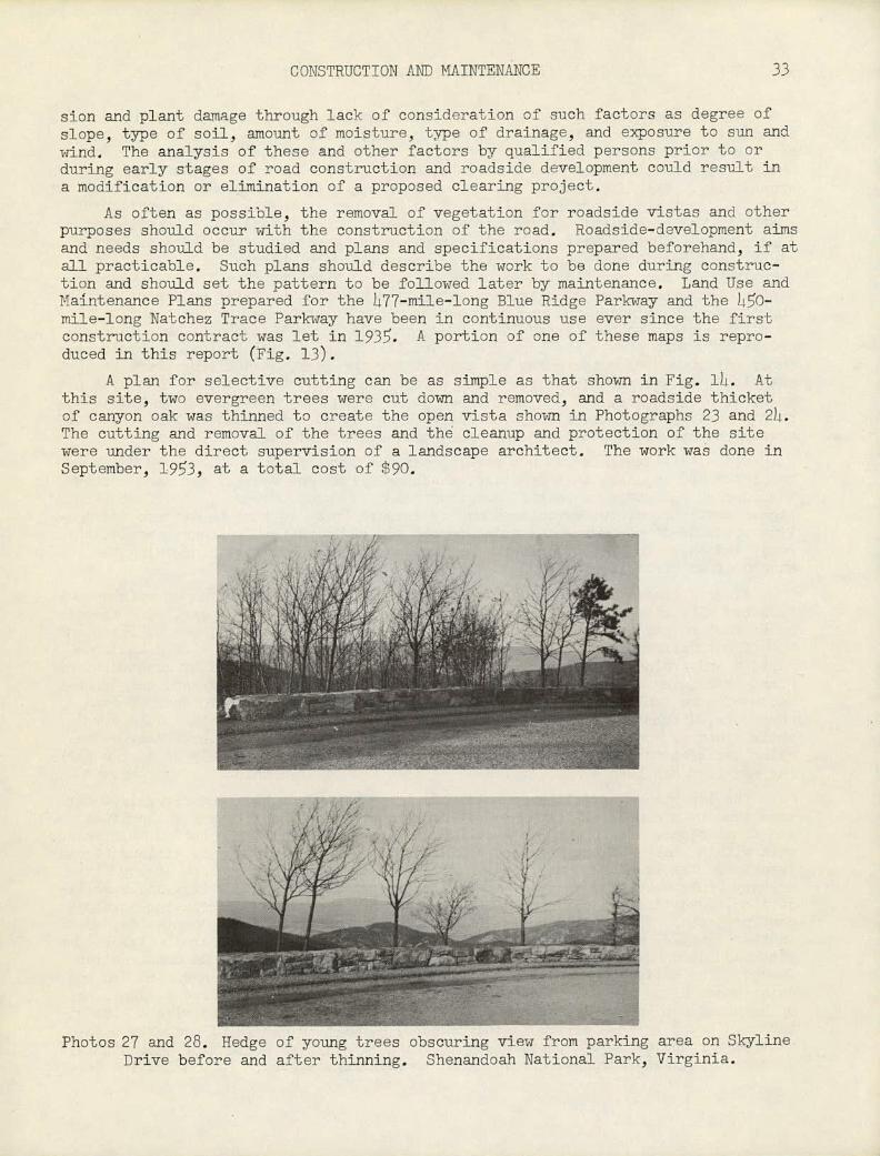
A plan for selective cutting can be as simple as that shown in Fig. 1)4. At this site, two evergreen trees were cut down and removed, and a roadside thicket of canyon oak was thinned to create the open vista shown in Photographs 23 and 2h. The cutting and removal of the trees and the cleanup and protection of the site were under the direct supervision of a landscape architect. The work was done in September, 193, at a total cost of $90.
Photos 27 and 28. Hedge of young trees obscuring view from parking area on Skyline Drive before and after thinning. Shenandoah National Park, Virginia.
34 SELECTIVE CUTTING OF ROADSIDE VEGETATION
For projects that are more extensive and complex, plans should be drawn des-cribing the limits to which clearing may be done, the zones where transition thin-ning is required, the large trees that are to be removed, the project limits for using or storing equipment and materials, and other pertinent data that can be shown graphically. Specifications should be written supporting the plans and spelling out in detail such major factors as (a) work to be done, including the designation of authority and responsibility for the performance, supervision, and inspection of construction operations; (b) materials to be used, including uch items as herbi-cides, soil conditioners and fertilizers, composition of borrow for backfill, ma-terials to be used for plant protection, a list of plant materials, and a tabula-tion of the kinds, sizes, units, and quantities of all materials; (c) method of do-ing the work, including the sequence and manner of operations, the care and protec-tion to be given to plants and land areas, the repair that should be made for dam-age or injury to plants and land areas, and the extent to which cleanup should be done; (d) method of measurement and payment for the work, identifying items of work, materials, or equipment that are to be paid by unit cost per item, by unit cost per area, or by quantity, and the conditions under which compensation may be made; (e) special provisions, describing items of work or methods of procedure that are of a special nature and not covered in the general specifications.
Often, circumstances do not permit roadside development until a road has been completed and in use. At this stage, clearing operations usually are more costly than during the stage of initial construction of a road. However, to offset this higher cost factor, two advantages may be drawn: There is time to observe and ana-lyze roadside-development need according to actual driver and passenger use of the road, and there is time to prepare for the work to be done, thus minimizing the hazard of an error in planning.
After a clearing project has been completed, it becomes an item of maintenance. At every site where vegetation has been removed, for whatever purpose, some mainte-nance must be performed periodically in order to retain the result accomplished and the effect desired. Nature'is not static. New plants volunteer quickly and grow rapidly and profusely in artificially favorable conditions created by construction. Plants remaining after selective thinning tend to become more leafy and larger be-cause of more sunlight and less competition. Without adequate maintenance, road shoulders, ditches, and slopes could become overgrown. Framed vistas could have their pictures "painted out" by a hedge of seedling trees and shrubs. Many a tra-veler has been more than mildly annoyed because the only view from a road or a park-ing overlook has been a "picket fence" of tree trunks or a thicket of shrubs.
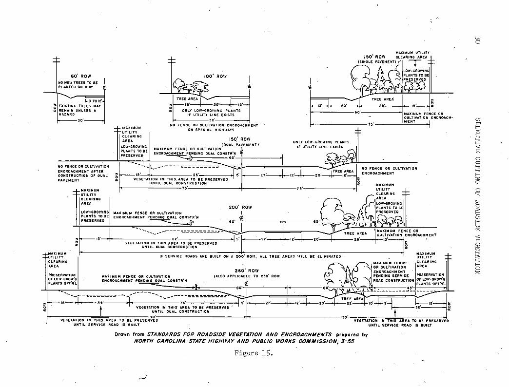
The importance of maintenance in roadside development has been recognized for some time by a number of state highway departments and other highway authorities and commissions. The problem of how to describe and accomplish required maintenance work within rights-of-way has been approached in a number of ways by various highway agencies. The New York State Department of Public Works, and the New Jersey State Highway Department, for example, prepare sets of construction drawings and specifi-cations, advertise for competitive bids, and award contracts for roadside-develop-ment projects. The North Carolina State Highway and Public Works Commission, as another example, modifies a set of regulations and a plan of standards (Fig. l) to fit roadside conditions and performs the necessary work with its own construction forces. The National Park Service may use sets of specifications and Land Use and Maintenance Plans and have the work done either by contract, by force account, or by "special use" permit. A special use permit is a document, often with a plan at-tached, issued by the Service to individuals, permitting owners of property adja-cent to a roadside to use portions of the right-of-way for conforming agricultural or other specified purposes according to certain regulations. It enables the Ser-
CONSTWCTI0N AND MATNTENANCE
3
;.;z-
_-c. ---
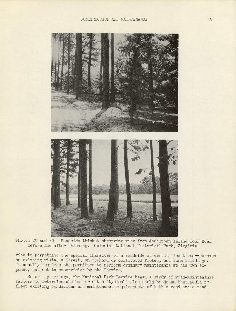
Photos 29 and 30. Roadside thicket obscuring view from Jamestown Island Tour Road before and after thinning. Colonial National Historical Park, Virginia.
vice to perpetuate the special character of a roadside at certain-locations—perhaps an existing vista, a forest, an orchard or cultivated fields, and farm buildings. It usually requires the permJttee to perform ordinary maintenance at his own ex-pense, subject to supervision by the Service.
Several years ago, the National Park Service began a study of road-maintenance factors to determine whether or not a hltypicalTt plan could be drawn that would re-flect existing conditions and maintenance requirements of both a road and a road-
Heirs of_Mrs. Ella Read Hatcher 121
DRAWN FROM
VISTA CLEARING PLAN OPEN VISTA - SECTION I-K, STA.495-505
- BLUE RIDGE PARKWAY
V IRGNIA
Figure 17.
SELECTIVE-CUTTING PRACTICES 37
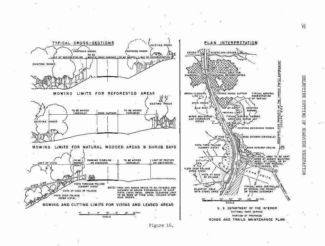
side. Special attention was given to roadside-development phases of the problem, using Parkway Land Use Plans as a pattern. A "sample" vista-clearing project was initiated in each of the then four regions of the Service; in Shenandoah National Park, Virginia; in Glacier NationalPark, Montana; in Zion National Park, Utah; and in Yosemite National Park, California. A portion of one of the proposed maintenance plans is produced in this report (Fig. 16). A number of sets of "before and after" photographs of vista-clearing operations also are included (See Photographs 18 and 19; also 21 to 30).
SELECTIVE-CUTTING PRACTICES
The practice of selective cutting of roadside vegetation seems, by consensus, to reflect the adage that "an ounce of prevention is worth a pound of cure."
At sites where extensive clearing is to be done, it has been determined, by inquiry, that it is considered better to remove vegetation progressively, in two or three operations extending over several years, than to clear away all of it in one operation. This more cautious procedure permits time for study of contingent fac-tors (soil, slope, moisture, etc.) and a gradual development of a desired effect, with less danger of error. Usually, as a first operation, all low plants such as weeds, vines, low shrubs, and seedling trees are cut by brushhook, axe, or sickle, and the slash removed. The cut stumps of perennial plants that could regenerate by suckering are then sprayed with a herbicide. Care should be taken that the spraying is selective rather than general. A first cutting of this nature helps to define the limits of clearing, facilitates the movement of men and equipment in the area, and determines where, how much, and what kind of additional material still should be removed. At a second selective-cutting operation during the same season, in another season, or another year, all plants that have seeded or suckered after the first cutting should be cut and removed, and the stumps sprayed. Larger trees may then be cut according to pattern by axe, hand saw, or power saw; large limbs and trunks removed; and the cut stumps sprayed. Smaller limbs and slash may be re-duced in size, either manually or mechanically, and the reduced material broadcast over the area as a mulch to retain moisture and retard erosion. If a third cutting is required, the removal and disposal of trees and other material should follow the same practice as for the second cutting, except that this time the project should be completed and the desired effect achieved. It is good practice to cut all plant material flush with the ground and then, after spraying, fill all depressions with woods soil and rake a cover of humus over the cut area. It should then be possible to retain this finished effect with routine, maintenance performed every two or three years. If the effect achieved is that of a roadside meadow or bay, it may be necessary to mow the area two or three times each year or to brush out woody her-baceous plants once a year before they seed. This will keep woody plants low and will allow grass and wildflowers to grow in the meadow or bay.
At some sites, extensive slearing may be done as a part of the initial con-struction of the rOad (on cut and fill slopes, shoulders, and ditches). At these sites, the planned development may require that some regeneration of plants be per-mitted for a period of time (on cuts and fills) before the selective thinning of this material may be done as a maintenance operation. On road shoulders cpmposed of granular material, undesirable plant growth may be removed by grubbing, mowing, or spraying. Turf shoulders may be maintained by mowing as many times during a growing season as conditions warrant. In ditches, volunteer plant growth may be removed by grubbing or spraying. . .
There is considerable variety in the size and composition of a crew organized to do selective cutting of trees and shrubs, and in the kinds and types of material
•• •••
* - -
St j4oton0l rO \ -•--- -. 2325 - ----•-..•-•'•-"- -
.148 SC ALE
100 0 00' 200 300' I -
DRAWN FROM
VISTA CLEARING PLAN CANOPY VISTA - SECTION I-K, STA. 433-437
BLUE RIDGE PARKWAY V I R G I N I A
Figure 18.

COSTS
39
and equipment needed to perform the work most effectively. Crews and equipment sometimes are determined by the nature of the terrain and the size and amount of plants to be removed, both of which affect the amount of manpower or machinepower that can be used.
For one contract in New York State, it was observed that the most effective crew consisted of a foreman who also did the spraying of stumps, three pairs of chain-saw operators, and two laborers who kept several wood fires burning for the disposal of the cut material. For several contracts, the felled trees were cut into Lv.ft cord lengths and hauled away free by wood dealers, thus eliminating the necessity of burning the wood.
On the Blue Ridge Parkway in Virginia, the crews working on two force-account vista-clearing projects consisted of nine men each: a maintenance foreman, one back-pack spray operator, two chain-saw operators, and five laborers. At another site, where routine maintenance was being provided for an area that had been cleared two years earlier, the crew consisted of a foreman who was also the spray operator, one man using a brushhook, and two laborers.
For a selective thinning contract in New Jersey, the contractor used a power-driven wood chipper to reduce brush, limbs, and small trees to a size that would make the material valuable as a mulch.
In North Carolina, force-account selective-cutting operations reveal by ex-perience that a crew foreman cannot select plants properly with six or seven men cutting, nor can four or five selectors, no matter how experienced, work in one location effectively. It was preferred that a crew consist of a foremn, one or two selectors, a chain-saw operator, a chemical-spray operator, a wood-chipper op-erator, and laborers as needed to feed the chipper and to cut weeds, briars, and nonwoody brush,
COSTS
The cost in dollars of the work of selective cutting derives from certain fundamental sources, i.e., the unit costs of items of work. However, the compiled total cost of the work is not always expressed in terms of units of measure that are common to all highway departments, commissions, authorities, or other highway agencies.
These units of measure may be miles of length, acres of size, number of sites, or units of work. Information received from North Carolina indicates that the force-account cost of selective cutting varies from $50 to $300 per mile; that con-tract costs in New York vary from $200 to $600 per acre; that contract costs in 1955 in New Jersey were a minimum of $325 per acre and a maximum of $360 per acre. Examination of a number of contracts for vista clearing (1952) on the Blue Ridge Parkway on a cost-per-site basis reveals the following: in Virginia, 43 sites were cleared at a cost of $15 per site, 66 sites at a cost of $25 per site; in North Carolina, 70 sites were cleared at a cost of $40 per site. In Zion National Park, Utah, vista clearing by force account cost $10 per tree for 250 mature trees and $5 per small tree or large shrub for 450 such plants. At Mount Rainier National Park, Washington, an estimate of $50 per tree at four separate sites is reported. In Sequoia National Park, California, the cost of removing one sequoia felled by an eroding slope was $500 (see Photograph 12), In Great Smoky Mountains National Park, on the Tennessee side, conforming land use and vistas were perpetuated on 1,239 roadside acres at no cost to the government through special use permits.
There is considerable labitude in the range of unit costs of the various items of work that constitute a selective-cutting project. These costs are affected by
40 SELECTIVE CUTTING OF ROADSIDE VEGETATION
many factOrs: the size of the project; the amount and size of plant materials to. be removed and the manner of disposal; the proximity of the project to sources of labor, materials, and equipment; local labor rates and the availability of labor, materials, and equipment; and the tolerance of specifications and supervision, to name a few. Sometimes the project is part of a general road-construction contract and the lowest bid quoted for selective cutting is not necessarily the one for which a contract is awarded.
The following tabulation reflects the wide variation in unit costs for many items of work, country-wide:
TABLE )4.
SELECTIVE-CUTTING COSTS Work Item Unit Cost
Brush cutting, by hand acre $25-150 mile i/ $40- 50
Brush cutting, by machine acre $10- 25
Chemical spraying 2/ contact translocation acre $300-600
1st year, 7510 control acre $75-15O 2nd.year, 9510 control acre $75-15O Retreatment, if necessary. acre $10- 15
Mowing grass acre $10- 20
Selective cutting of ed.sting trees and shrubs 3/ acre $30-600 - mile $50-300
Trimming edsting trees, 6-inch caliper each $5— 10 U Ti Ti 12- Ti U it $10- 15 U Ti 11 20- U U U $15- 20 TI -IT It 30- TI IT IT $20- 30 It U U 36— 11
It IT $30- 40
Tree removal 6-12-inch caliper each $20- 30 U II 12-18- -U IT 11 $30- 50 U 11 18-24- II TI U $50- 70 IT II 24-30- U II it $70- 90 II TI 30-36- it U it $90-130
!"Limited to cut and fill dimensions of road prism.
"Roadside Vegetative Cover, Research Project,1T March, 1954, Landscape Bureau, Department of Public Works.
"Maryland, 1955 Light clearing, acre $150. 200 - Medium It U $250-300 Heavy It 11 s350-500
New York, 1952-53 II $200-600
New Jersey, 1955 II $325-360
North Carolina, 1956 mile $50-300
Virginia, 1952, Blue Ridge acre $30- 61 Parkway (Does not include cost of professional super-vision)

COSTS Li
In the tabulation of selective- cutting costs, attention is directed to foot-note 3/ of the work item Tt5elective cutting of trees and shrubs."
In October, 1952, the National Park Service set up two demonstration vista-clearing projects on Section 1-K, Blue Ridge Parkway, Virginia; one an open vista and the other a canopy vista.
The two sites were studied beforehand by the Paikay landscape architect, engineer, and other professionals. Drawings were prepared for each site, showing the limits and requirements of the proposed work (see Figs. 17 and 18). A crew was organized, and materials and equipment collected At a normal pace and under close supervision of the landscape architect and the engineer, the vista clearings for the two sites were begun and completed in two days. The weather was clear and cool; the elevation about 2,00 feet. The average age of a crewman was about 3 years, and each man was experienced in the use of wood-cutting tools and equipment.
The site of the open vista was partly on a LiD-ft high, l-year-old fill on which no previous vista clearing had been performed and partly in an existing grove of trees that had not been thinned. Much of the vegetation on the fill consisted of patches of briars,, clumps of sumac, small sassafras and locust, and a number of paulownia that had reached a caliper of 12 inches. Most of the cut material was reduced in size and allowed to remain on the slope as a mulch; the remainder was pulled beyond the limits of clearing and left as part of the forest floor. In the grove of trees, mixed hardwoods up to 12 inches in caliper were removed. This cut material was pulled beyond the limits of clearing and allowed to remain.
The site of the canopy vista was a moderate downslope in a dense grove of mixed hardwoods and pines that had not been thinned previously.. Most of the trees removed were hardwoods having an average caliper of 8 inches, although several trees were 18 inches in caliper. Much of the cut material was permitted to remain beyond the limits of clearing; the larger tree trunks were cut to 8-ft lengths and removed by truck.
A tabulated resume of labor, time, equipment and cost factors follows:
TABLE
SELECTIVE-CWfTING COSTS
Open Vista: Stations 1.38 acres open, 0.23 acre woods -
Maintenance foreman 14-1/2 hours @ $2.00 $9.00 Laborers - men 14-1/2 hours @ .80 18.00
2 men 14-1/2 hours @ .85 7.6 1 man 14-1/2 hours @ .90 4.05
Equipment rental and amortization 2 pickup trucks 50 miles @ '.07 3.0
Overhead - chain saw and 2, 14, -T spray 5.80 Total $148.00
Canopy Vista: Stations 433-437, 1.00 acre Maintenance foreman Laborers - men
2' men 1 man
Equipment rental and' amortization 2 pickup trucks
Overhead - chain saw and spray
6 hours @ $2.00 $12.00 6 hours @ .80 214.00 6 hours @ .85 10.20 6 hours @ .90 5.40
O miles @ .07 ' 3.5O
Total

142 SELECTIVE CIJTI'TTNG OF ROADSJJJE VEGETATION
CONCLUSION
In years past, some selective cutting and maintenance projects have not had the good fortune of complete management. Some project history has' not been re-corded, statistically or graphically, and this omission cannot be corrected. In this respect, there always will be gaps in the 'record. For some projects, there are complete and valuable records. Other projects are in an active stage, and data concerning progress will, become available from time to time. Information that por-trays the ?Tbefore, during, and aftertt status of present selective-cutting construc-tion and maintenance operations will be of great value, in providing a basis for the development of criteria costs and methods of procedure for future projects. In light of a growing awareness of the importance of the subject of roadside develop-ment in an expanding highway construction and improvement program, this report marks a showing of interest and information in one phase of the general subject—the phase of selective cutting of roadside 'egetation 'for improved highway safety, appearance, and use.
OR- 2 l
THE NATIONAL ACADEMY OF SCIENCES—NATIONAL RESEARCH COUN-CIL is a private, nonprofit organization of scientists, dedicated to the furtherance of science and to its use for the general welfare. The
ACADEMY itself was established in 1863 under a congressional charter signed by President Lincoln. Empowered to provide for all activities ap-propriate to academies of science, it was also required by its charter to act as an adviser to the federal government in scientific matters. This provision accounts for the close ties that have always existed between the ACADEMY and the government, although the ACADEMY is not a govern-mental agency.
The NATIONAL RESEARCH COUNCIL was established by the ACADEMY in 1916, at the request of President Wilson, to enable scientists generally to associate their efforts with those of the limited membership of the ACADEMY in service to the nation, to society, and to science at home and abroad. Members of the NATIONAL RESEARCH COUNCIL receive their appointments from the president of the ACADEMY. They include representa-tives nominated by the major scientific and technical societies, repre-sentatives of the federal government, and a number of members at large. In addition, -several thousand scientists and engineers take part in the activities of the research council through membership on its various boards and committees.
Receiving funds from both public and private sources, by contribution, grant, or contract, the ACADEMY and its RESEARCH COUNCIL thus work to stimulate research and its applications, to survey the broad possibilities of science, to promote effective utilization of the scientific and technical resources of the country, to serve the government, and to further the general interests of science.
The HIGHWAY RESEARCH BOARD was organized November 11, 1920, as an agency of the Division of Engineering and Industrial Research, one of the eight functional divisions of the NATIONAL RESEARCH COUNCIL. The BOARD is a cooperative organization of the highway technologists of America operating under the auspices of the ACADEMY-COUNCIL and with the support of the several highway departments, the Bureau of Public Roads, and many other organizations interested in the development of highway transportation. The purposes of the BOARD are to encourage research and to provide a national clearinghouse and correlation service for research activities and information on highway administration and teéhnology.


![1] (: 311 - Transportation Research Boardonlinepubs.trb.org/Onlinepubs/nchrp/nchrp_syn_141.pdf · JOHN GRAY, President, National Asphalt Pavement Association (cx officio) THOMAS H.](https://static.fdocuments.in/doc/165x107/5ed016b4160afc65d9458562/1-311-transportation-research-john-gray-president-national-asphalt-pavement.jpg)